
Articles | Volume 18, issue 7
https://doi.org/10.5194/nhess-18-1919-2018
© Author(s) 2018. This work is distributed under
the Creative Commons Attribution 4.0 License.
the Creative Commons Attribution 4.0 License.
https://doi.org/10.5194/nhess-18-1919-2018
© Author(s) 2018. This work is distributed under
the Creative Commons Attribution 4.0 License.
the Creative Commons Attribution 4.0 License.
Research article
| 
10 Jul 2018
Research article |
| 10 Jul 2018
| 10 Jul 2018
Application of a physically based model to forecast shallow landslides at a regional scale
Teresa Salvatici
Department of Earth Sciences, University of Florence, Florence, 50121,
Italy
Veronica Tofani
CORRESPONDING AUTHOR
Department of Earth Sciences, University of Florence, Florence, 50121,
Italy
Guglielmo Rossi
Department of Earth Sciences, University of Florence, Florence, 50121,
Italy
Michele D'Ambrosio
Department of Earth Sciences, University of Florence, Florence, 50121,
Italy
Carlo Tacconi Stefanelli
Department of Earth Sciences, University of Florence, Florence, 50121,
Italy
Elena Benedetta Masi
Department of Earth Sciences, University of Florence, Florence, 50121,
Italy
Ascanio Rosi
Department of Earth Sciences, University of Florence, Florence, 50121,
Italy
Veronica Pazzi
Department of Earth Sciences, University of Florence, Florence, 50121,
Italy
Pietro Vannocci
Department of Earth Sciences, University of Florence, Florence, 50121,
Italy
Miriana Petrolo
Department of Earth Sciences, University of Florence, Florence, 50121,
Italy
Filippo Catani
Department of Earth Sciences, University of Florence, Florence, 50121,
Italy
Sara Ratto
Centro funzionale, Regione Autonoma Valle d'Aosta, Aosta, 11100, Italy
Hervè Stevenin
Centro funzionale, Regione Autonoma Valle d'Aosta, Aosta, 11100, Italy
Nicola Casagli
Department of Earth Sciences, University of Florence, Florence, 50121,
Italy
Related authors
V. Bonora, I. Centauro, L. Fiorini, A. Conti, T. Salvatici, S. Calandra, R. Raffa, E. Intrieri, C. A. Garzonio, and G. Tucci
Int. Arch. Photogramm. Remote Sens. Spatial Inf. Sci., XLVIII-M-2-2023, 273–280, https://doi.org/10.5194/isprs-archives-XLVIII-M-2-2023-273-2023, https://doi.org/10.5194/isprs-archives-XLVIII-M-2-2023-273-2023, 2023
Qingkai Meng, Yong Dai, Filippo Catani, Shilong Chen, Qiuhui Wang, Qing Li, Ying Peng, Han Wu, and Ying Meng
EGUsphere, https://doi.org/10.5194/egusphere-2026-2637, https://doi.org/10.5194/egusphere-2026-2637, 2026
Preprint archived
Short summary
Short summary
This study introduces a transparent graph-based method to improve landslide susceptibility assessment. Instead of treating terrain, rainfall, snowmelt, rivers, faults, and slope shape as separate factors, it links them into spatial dependency pathways and measures how their influences connect across a region. In the Ili River Basin, the method identified fourteen pathways and mapped where each matters most. This helps explain why places are prone to landslides and supports targeted management.
Lukas Schild, Ascanio Rosi, and Filippo Catani
EGUsphere, https://doi.org/10.5194/egusphere-2026-1796, https://doi.org/10.5194/egusphere-2026-1796, 2026
Short summary
Short summary
We developed a transparent machine learning model that forecasts rainfall-triggered landslides from satellite rain data. It matches the accuracy of complex models while staying easy to understand, and keeps missed warnings low. We also introduce simple visual thresholds to help decision-makers use the predictions. This is needed, for example, for Early Warning Systems, where it is extremely helpful to understand the models' predictions.
Lorenzo Nava, Alessandro Mondini, Kushanav Bhuyan, Chengyong Fang, Oriol Monserrat, Alessandro Novellino, and Filippo Catani
Geosci. Model Dev., 19, 167–185, https://doi.org/10.5194/gmd-19-167-2026, https://doi.org/10.5194/gmd-19-167-2026, 2026
Short summary
Short summary
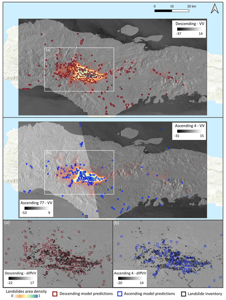
This paper presents a framework for landslide rapid detection using radar and deep learning, trained and tested on data from ≈73000 landslides across diverse regions in the world. The method showed high accuracy and rapid response potential regardless of weather and illumination conditions. By overcoming the limits of optical satellite imagery, it offers a powerful tool for timely landslide disaster response, benefiting disaster management and advancing methods for monitoring hazardous terrains.
Matteo Trolese, Alessandro Tadini, Laura Pieretti, Damiano Biagini, Spina Cianetti, Simone Colucci, Matteo Cerminara, Claudia D'Oriano, Chiara Montagna, Michele D'Ambrosio, Raffaello Pegna, Giuseppe Re, Francesco Sanseverino, Carlo Giunchi, Carlo Meletti, and Tomaso Esposti Ongaro
Geosci. Commun., 8, 319–337, https://doi.org/10.5194/gc-8-319-2025, https://doi.org/10.5194/gc-8-319-2025, 2025
Short summary
Short summary
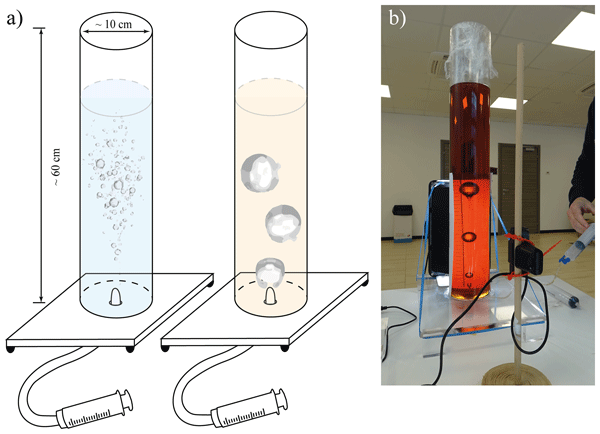
This study describes two hands-on outreach events: an interactive lesson for high-school students during European Researchers’ Night and a tsunami experiment at Lucca Comics & Games. Surveys showed both groups enjoyed the activities, boosted their grasp of geoscience ideas and grew more positive about science. The work emphasizes the effectiveness of quantitative experiment demonstrations and the need to adapt them to the audience, time available and clear educator coordination.
Lorenzo Nava, Alessandro Novellino, Chengyong Fang, Kushanav Bhuyan, Kathryn Leeming, Itahisa Gonzalez Alvarez, Claire Dashwood, Sophie Doward, Rahul Chahel, Emma McAllister, Sansar Raj Meena, and Filippo Catani
Nat. Hazards Earth Syst. Sci., 25, 2371–2377, https://doi.org/10.5194/nhess-25-2371-2025, https://doi.org/10.5194/nhess-25-2371-2025, 2025
Short summary
Short summary
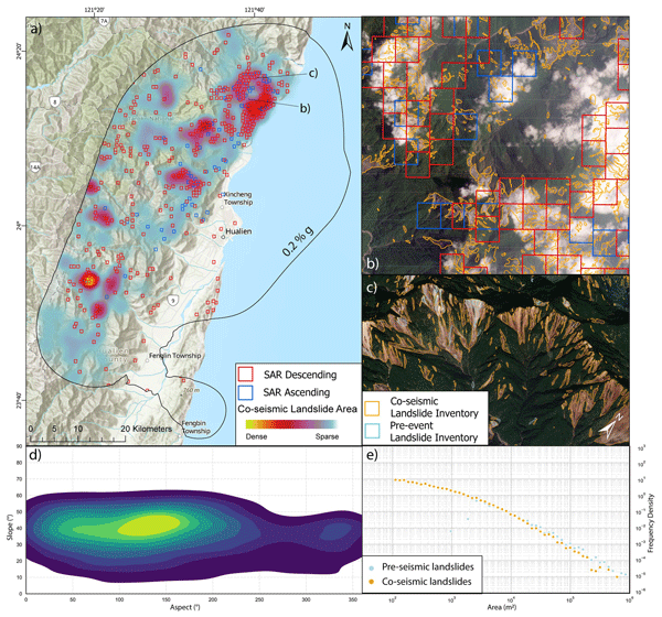
On 2 April 2024, a Mw 7.4 earthquake hit Taiwan's eastern coast, causing extensive landslides and damage. We used automated methods combining Earth observation (EO) data with AI to quickly inventory the landslides. This approach identified 7090 landslides over 75 km2 within 3 h of acquiring the EO imagery. The study highlights AI's role in improving landslide detection efforts in disaster response.
Chengyong Fang, Xuanmei Fan, Xin Wang, Lorenzo Nava, Hao Zhong, Xiujun Dong, Jixiao Qi, and Filippo Catani
Earth Syst. Sci. Data, 16, 4817–4842, https://doi.org/10.5194/essd-16-4817-2024, https://doi.org/10.5194/essd-16-4817-2024, 2024
Short summary
Short summary
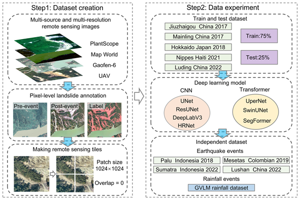
In this study, we present the largest publicly available landslide dataset, Globally Distributed Coseismic Landslide Dataset (GDCLD), which includes multi-sensor high-resolution images from various locations around the world. We test GDCLD with seven advanced algorithms and show that it is effective in achieving reliable landslide mapping across different triggers and environments, with great potential in enhancing emergency response and disaster management.

Carlo Tacconi Stefanelli, William Frodella, Francesco Caleca, Zhanar Raimbekova, Ruslan Umaraliev, and Veronica Tofani
Nat. Hazards Earth Syst. Sci., 24, 1697–1720, https://doi.org/10.5194/nhess-24-1697-2024, https://doi.org/10.5194/nhess-24-1697-2024, 2024
Short summary
Short summary
Central Asia regions are marked by active tectonics, high mountains with glaciers, and strong rainfall. These predisposing factors make large landslides a serious threat in the area and a source of possible damming scenarios, which endanger the population. To prevent this, a semi-automated geographic information system (GIS-)based mapping method, centered on a bivariate correlation of morphometric parameters, was applied to give preliminary information on damming susceptibility in Central Asia.
Francesco Caleca, Chiara Scaini, William Frodella, and Veronica Tofani
Nat. Hazards Earth Syst. Sci., 24, 13–27, https://doi.org/10.5194/nhess-24-13-2024, https://doi.org/10.5194/nhess-24-13-2024, 2024
Short summary
Short summary
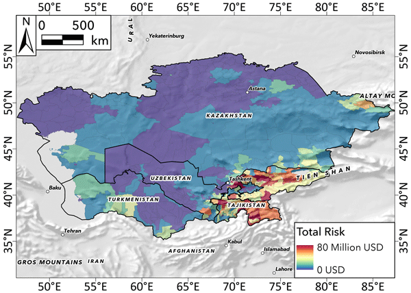
Landslide risk analysis is a powerful tool because it allows us to identify where physical and economic losses could occur due to a landslide event. The purpose of our work was to provide the first regional-scale analysis of landslide risk for central Asia, and it represents an advanced step in the field of risk analysis for very large areas. Our findings show, per square kilometer, a total risk of about USD 3.9 billion and a mean risk of USD 0.6 million.
Giulia Blandini, Francesco Avanzi, Simone Gabellani, Denise Ponziani, Hervé Stevenin, Sara Ratto, Luca Ferraris, and Alberto Viglione
The Cryosphere, 17, 5317–5333, https://doi.org/10.5194/tc-17-5317-2023, https://doi.org/10.5194/tc-17-5317-2023, 2023
Short summary
Short summary
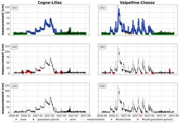
Automatic snow depth data are a valuable source of information for hydrologists, but they also tend to be noisy. To maximize the value of these measurements for real-world applications, we developed an automatic procedure to differentiate snow cover from grass or bare ground data, as well as to detect random errors. This procedure can enhance snow data quality, thus providing more reliable data for snow models.
Sansar Raj Meena, Lorenzo Nava, Kushanav Bhuyan, Silvia Puliero, Lucas Pedrosa Soares, Helen Cristina Dias, Mario Floris, and Filippo Catani
Earth Syst. Sci. Data, 15, 3283–3298, https://doi.org/10.5194/essd-15-3283-2023, https://doi.org/10.5194/essd-15-3283-2023, 2023
Short summary
Short summary
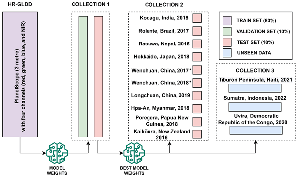
Landslides occur often across the world, with the potential to cause significant damage. Although a substantial amount of research has been conducted on the mapping of landslides using remote-sensing data, gaps and uncertainties remain when developing models to be operational at the global scale. To address this issue, we present the High-Resolution Global landslide Detector Database (HR-GLDD) for landslide mapping with landslide instances from 10 different physiographical regions globally.
V. Bonora, I. Centauro, L. Fiorini, A. Conti, T. Salvatici, S. Calandra, R. Raffa, E. Intrieri, C. A. Garzonio, and G. Tucci
Int. Arch. Photogramm. Remote Sens. Spatial Inf. Sci., XLVIII-M-2-2023, 273–280, https://doi.org/10.5194/isprs-archives-XLVIII-M-2-2023-273-2023, https://doi.org/10.5194/isprs-archives-XLVIII-M-2-2023-273-2023, 2023
Ascanio Rosi, William Frodella, Nicola Nocentini, Francesco Caleca, Hans Balder Havenith, Alexander Strom, Mirzo Saidov, Gany Amirgalievich Bimurzaev, and Veronica Tofani
Nat. Hazards Earth Syst. Sci., 23, 2229–2250, https://doi.org/10.5194/nhess-23-2229-2023, https://doi.org/10.5194/nhess-23-2229-2023, 2023
Short summary
Short summary
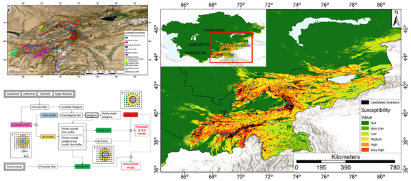
This work was carried out within the Strengthening Financial Resilience and Accelerating Risk Reduction in Central Asia (SFRARR) project and is focused on the first landslide susceptibility analysis at a regional scale for Central Asia. The most detailed available landslide inventories were implemented in a random forest model. The final aim was to provide a useful tool for reduction strategies to landslide scientists, practitioners, and administrators.
Francesco Avanzi, Simone Gabellani, Fabio Delogu, Francesco Silvestro, Flavio Pignone, Giulia Bruno, Luca Pulvirenti, Giuseppe Squicciarino, Elisabetta Fiori, Lauro Rossi, Silvia Puca, Alexander Toniazzo, Pietro Giordano, Marco Falzacappa, Sara Ratto, Hervè Stevenin, Antonio Cardillo, Matteo Fioletti, Orietta Cazzuli, Edoardo Cremonese, Umberto Morra di Cella, and Luca Ferraris
Earth Syst. Sci. Data, 15, 639–660, https://doi.org/10.5194/essd-15-639-2023, https://doi.org/10.5194/essd-15-639-2023, 2023
Short summary
Short summary
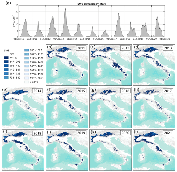
Snow cover has profound implications for worldwide water supply and security, but knowledge of its amount and distribution across the landscape is still elusive. We present IT-SNOW, a reanalysis comprising daily maps of snow amount and distribution across Italy for 11 snow seasons from September 2010 to August 2021. The reanalysis was validated using satellite images and snow measurements and will provide highly needed data to manage snow water resources in a warming climate.
Francesco Avanzi, Simone Gabellani, Fabio Delogu, Francesco Silvestro, Edoardo Cremonese, Umberto Morra di Cella, Sara Ratto, and Hervé Stevenin
Geosci. Model Dev., 15, 4853–4879, https://doi.org/10.5194/gmd-15-4853-2022, https://doi.org/10.5194/gmd-15-4853-2022, 2022
Short summary
Short summary
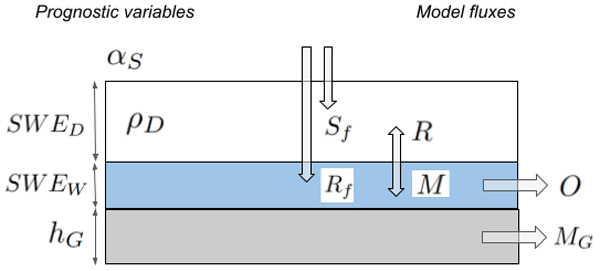
Knowing in real time how much snow and glacier ice has accumulated across the landscape has significant implications for water-resource management and flood control. This paper presents a computer model – S3M – allowing scientists and decision makers to predict snow and ice accumulation during winter and the subsequent melt during spring and summer. S3M has been employed for real-world flood forecasting since the early 2000s but is here being made open source for the first time.
Sansar Raj Meena, Silvia Puliero, Kushanav Bhuyan, Mario Floris, and Filippo Catani
Nat. Hazards Earth Syst. Sci., 22, 1395–1417, https://doi.org/10.5194/nhess-22-1395-2022, https://doi.org/10.5194/nhess-22-1395-2022, 2022
Short summary
Short summary
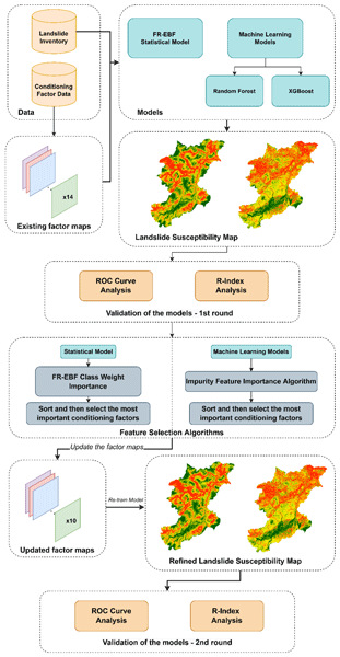
The study investigated the importance of the conditioning factors in predicting landslide occurrences using the mentioned models. In this paper, we evaluated the importance of the conditioning factors (features) in the overall prediction capabilities of the statistical and machine learning algorithms.
Cited articles
Aleotti, P.: A warning system for rainfall-induced shallow failures, Eng.
Geol., 73, 247–265, https://doi.org/10.1016/j.enggeo.2004.01.007, 2004.
Amoozegar, A.: Compact constant head permeameter for measuring saturated
hydraulic conductivity of the vadose zone, Soil Sci. Soc. Am. J., 53,
1356–1361, 1989.
Arnone, E., Noto, L. V., Lepore, C., and Bras, R. L.: Physically- based and
distributed approach to analyse rainfall-triggered land- slides at watershed
scale, Geomorphology, 133, 3–4, 121–131, 2011.
Baroni, G., Facchi, A., Gandolfi, C., Ortuani, B., Horeschi, D., and van Dam,
J. C.: Uncertainty in the determination of soil hydraulic parameters and its
influence on the performance of two hydrological models of different
complexity, Hydrol. Earth Syst. Sci., 14, 251–270,
https://doi.org/10.5194/hess-14-251-2010, 2010.
Baum, R., Savage, W., and Godt, J.: Trigrs: A FORTRAN program for transient
rainfall infiltration and grid-based regional slope – stability analysis,
Open-file Report, US Geol. Survey, 2002, USGS Open-File Report 02-424,
Reston, VA, available at: http://pubs.usgs.gov/of/2002/ofr-02-424/
(last access: 7 December 2016), 2002.
Baum, R. L. and Godt, J. W.: Early warning of rainfall-induced shallow
landslides and debris flows in the USA, Landslides, 7, 259–272, 2010.
Bicocchi, G., D'Ambrosio, M., Rossi, G., Rosi, A., Tacconi Stefanelli, C.,
Segoni, S., Nocentini, M., Vannocci, P., Tofani, V., Casagli, N., and Catani,
F.: Geotechnical in situ measures to improve landslides forecasting models:
A case study in Tuscany (Central Italy), Landslides and Engineered Slopes,
Experience, Theory and Practice, 2, 419–424, 2016.
Bischetti, G. B., Chiaradia, E. A., and Epis, T.: Prove di trazione su radici
di esemplari di piante pratiarmati, Rapporto interno, Istituto di Idraulica
Agraria, Università degli Studi di Milano, 2009.
Burylo, M.: Relations entre les traits fonctionnels des espèces
végétales et leurs fonctions de protection contre l'erosion dans le
milieu marneux restaurés de montagne, Dissertation, University of
Grenoble, France, 2010.
Cannon, S. H., Boldt, E. M., Laber, J. L., Kean, J. W., and Staley, D. M.:
Rainfall intensity – duration thresholds for postfire debris – flow
emergency-response planning, Nat. Hazards, 59, 209–236, 2011.
Carrara, A., Crosta, G., and Frattini, P.: Comparing models of debris-flow
susceptibility in the alpine environment, Geomorphology 94, 353–378, 2008.
Catani, F., Segoni, S., and Falorni, G.: An empirical geomorphology-based
approach to the spatial prediction of soil thickness at catchment scale,
Water Resour. Res., 46, W05508, https://doi.org/10.1029/2008WR007450, 2010.
De Giusti, F., Dal Piaz, G. V., Massironi, M., and Schiavo, A.: Carta
geotettonica della Valle d'Aosta alla scala 1 : 150.000, Mem. Sci. Geol., 55,
129–149, 2004.
Del Soldato, M., Segoni, S., De Vita, P., Pazzi, V., Tofani, V., and Moretti,
S.: Thickness model of pyroclastic soils along mountain slopes of Campania
(southern Italy), in: Landslides and Engineered Slopes, Experience, Theory
and Practice, Associazione Geotecnica Italaian, Aversa, et al. (Eds.), Rome,
Italy, 797–804, 2016.
Dietrich, W. and Montgomery, D.: Shalstab: a digital terrain model for
mapping shallow landslide potential, NCASI (National Council of the Paper
Industry for Air and Stream Improvement) Technical Report, February, 1998.
Fanelli, G., Salciarini, D., and Tamagnini, C.: Reliable soil property maps
over large areas: a case study in Central Italy, Enviro. Eng. Geosci., 22,
37–52, https://doi.org/10.2113/gseegeosci.22.1.37, 2016.
Giadrossich, F., Preti, F., Guastini, E., and Vannocci, P.: Metodologie
sperimentali per l'esecuzione di prove di taglio diretto su terre rinforzate
con radici, Experimental methodologies for the direct shear tests on soils
reinforced by roots, Geologia tecnica & ambientale, 4, 5–12, 2010.
Gray, D. H. and Ohashi, H.: Mechanics of fiber reinforcement in sand, J.
Geotech. Eng., 109, 335–353, 1983.
Jiang, S. H., Li, D. Q., Zhang, L. M., Zhou, C. B.: Slope reliability analysis
considering spatially variable shear strength parameters using a
non-intrusive stochastic finite element method, Eng. Geol, 168, 120–128,
2013.
Lagomarsino, D., Segoni, S., Fanti, R., and Catani, F.: Updating and tuning
a regional scale landslide early warning system, Landslides, 10, 91–97,
2013.
Lu, N. and Godt, J. W.: Infinite-slope stability under steady unsaturated
seepage conditions, Water Resour. Res., 44, W11404,
https://doi.org/10.1029/2008WR006976, 2008.
Martelloni, G., Segoni, S., Fanti, R., and Catani, F.: Rainfall thresholds
for the forecasting of landslide occurrence at regional scale, Landslides,
9, 485–495, 2012.
Mercogliano, P., Segoni, S., Rossi, G., Sikorsky, B., Tofani, V., Schiano,
P., Catani, F., and Casagli, N.: Brief communication “A prototype forecasting
chain for rainfall induced shallow landslides”, Nat. Hazards Earth Syst.
Sci., 13, 771–777, https://doi.org/10.5194/nhess-13-771-2013, 2013.
Operstein, V. and Frydman, S.: The influence of vegetation on soil
strength, Ground Improv., 4, 81–89, 2000.
Pack, R. T., Tarboton, D. G., and Goodwin, C. N.: Assessing terrain
stability in a gis using sinmap, in: “15th Annual GIS Conference, GIS 2001,
Vancouver, British Columbia, Canada, 2001.
Park, H. J., Lee, J. H., and Woo, I.: Assessment of rainfall-induced shallow
landslide susceptibility using a GIS-based probabilistic approach, Eng.
Geol., 161, 1–15, 2013.
Pollen, N., Simon, A., and Collison, A. J. C.: Advances in assessing the
mechanical and hydrologic effects of riparian vegetation on streambank
stability, in: Riparian Vegetation and Fluvial Geomorphology, Water Sci.
Appl. Ser., edited by: Bennett, S. and Simon, A., AGU, Washington, D. C.,
8, 125–139, 2004.
Rawls, W. J., Brakensiek, D. L., and Saxton, K. E.: Estimating soil water
properties, Transactions, ASAE, 25, 1316–1320 and p. 1328, 1982.
Ren, D., Fu, R., Leslie, L. M., Dickinson, R., and Xin, X.: A storm-triggered
landslide monitoring and prediction system: formulation and case study,
Earth Interact., 14, 1–24, 2010.
Rhynsburger, D.: Analytic delineation of Thiessen polygons, Geogr. Anal.,
5, 133–144, 1973.
Richards, L. A.: Capillary conduction of liquids through porous mediums, PhD
Thesis, Cornell University, New York, 1931.
Rosi, A., Segoni, S., Catani, F., and Casagli, N.: Statistical and envi-
ronmental analyses for the definition of a regional rainfall thresholds
system for landslide triggering in Tuscany (Italy), J. Geogr. Sci., 22,
617–629, 2012.
Rossi, G., Catani, F., Leoni, L., Segoni, S., and Tofani, V.: HIRESSS: a
physically based slope stability simulator for HPC applications, Nat. Hazards
Earth Syst. Sci., 13, 151–166, https://doi.org/10.5194/nhess-13-151-2013,
2013.
Salciarini, D., Tamagnini, C., Conversini, P., and Rapinesi, S.: Spatially
distributed rainfall thresholds for the initiation of shallow landslides,
Nat. Hazards, 61, 229–245, https://doi.org/10.1007/s11069-011-9739-2, 2012.
Salciarini, D., Fanelli, G., and Tamagnini, C.: A probabilistic model for
rainfall-induced shallow landslide prediction at the regional scale,
Landslides, 14,1731–1746, https://doi.org/10.1007/s10346-017-0812-0, 2017.
Segoni, S., Leoni, L., Benedetti, A. I., Catani, F., Righini, G., Falorni,
G., Gabellani, S., Rudari, R., Silvestro, F., and Rebora, N.: Towards a
definition of a real-time forecasting network for rainfall induced shallow
landslides, Nat. Hazards Earth Syst. Sci., 9, 2119–2133,
https://doi.org/10.5194/nhess-9-2119-2009, 2009.
Simoni, S., Zanotti, F., Bertoldi, G., and Rigon, R.: Modelling the
probability of occurrence of shallow landslides and channelized debris flows
using GEOtop-FS, Hydrol. Process., 22, 532–545, 2008.
Tofani, V., Bicocchi, G., Rossi, G., Segoni, S., D'Ambrosio, M., Casagli,
N., and Catani, F.: Soil characterization for shallow landslides modeling: a
case study in the Northern Apennines (Central Italy), Landslides, 14,
755–770, https://doi.org/10.1007/s10346-017-0809-8, 2017.
Vergani, C., Bassanelli, C., Rossi, L., Chiaradia, E. A., and Bischetti, G.
B.: The effect of chestnut coppice forest abandon on slope stability: a case
study, Geophys. Res Abstr, 15, EGU2013-10151, 2013.
Vergani, C., Giadrossich, F., Schwarz, M., Buckley, P., Conedera, M.,
Pividori, M., Salbitano, F., Rauch, H. S., and Lovreglio, R.: Root
reinforcement dynamics of European coppice woodlands and their effect on
shallow landslides, a review, Earth Sci. Rev., 167, 88–102,
https://doi.org/10.1016/j.earscirev.2017.02.002, 2017.
Wagner, A. A.: The use of the Unified Soil Classification System by the
Bureau of Reclamation, Proc. 4th Intern. Conf. Soil Mech. Found. Eng.,
London, 1, 125, 1957.
Waldron, L. J. and Dakessian, S.: Soil reinforcement by roots: calculations
of increased soil shear resistance from root properties, Soil Sci., 132,
427–435, 1981.
Short summary
In this paper, we present the application of the physically based HIRESSS model (High Resolution Stability Simulator) to forecast the occurrence of shallow landslides in a portion of the Aosta Valley region (Italy). An in-depth study of the geotechnical and hydrological properties of the hillslopes controlling shallow landslides formation was conducted, in order to generate an input map of parameters. The main aim of this study is to set up a regional landslide early warning system.
In this paper, we present the application of the physically based HIRESSS model (High Resolution...


Altmetrics
Final-revised paper
Preprint