
Articles | Volume 26, issue 10
https://doi.org/10.5194/nhess-26-5151-2026
© Author(s) 2026. This work is distributed under
the Creative Commons Attribution 4.0 License.
the Creative Commons Attribution 4.0 License.
https://doi.org/10.5194/nhess-26-5151-2026
© Author(s) 2026. This work is distributed under
the Creative Commons Attribution 4.0 License.
the Creative Commons Attribution 4.0 License.
Research article
| 
22 Oct 2026
Research article |
| 22 Oct 2026
| 22 Oct 2026
Temporal models for the occurrence of Etna eruptions and implications for hazard assessment

Istituto Nazionale di Geofisica e Vulcanologia, Sezione di Bologna, Bologna, Italy
Alexander Garcia
Istituto Nazionale di Geofisica e Vulcanologia, Sezione di Bologna, Bologna, Italy
Simona Scollo
Istituto Nazionale di Geofisica e Vulcanologia, Osservatorio Etneo, Catania, Italy
Luigi Mereu
Istituto Nazionale di Geofisica e Vulcanologia, Osservatorio Etneo, Catania, Italy
Michele Prestifilippo
Istituto Nazionale di Geofisica e Vulcanologia, Osservatorio Etneo, Catania, Italy
Related authors
Arnau Folch, Laura Sandri, Sara Barsotti, Simone Aguiar, Beatriz Martínez Montesinos, Alejandra Guerrero, Pablo Tierz, Heribert Pascual, Eva Hernandez, Leonardo Mingari, and Antonio Costa
EGUsphere, https://doi.org/10.5194/egusphere-2026-4485, https://doi.org/10.5194/egusphere-2026-4485, 2026
This preprint is open for discussion and under review for Natural Hazards and Earth System Sciences (NHESS).
Short summary
Short summary
Volcanic ash threatens communities near European volcanoes and aircraft across the continent. A new study has produced the first European hazard map for volcanic dispersal in the atmosphere, using more than 53,000 simulations of ash clouds from twelve European volcanoes, run on one of Europe's most powerful supercomputers. The results show where ash is likely to fall and which flight regions could be dangerous. Simulations are stored in an open catalogue that lets end-users update the hazard.
Alessandro Tadini, Andrea Bevilacqua, Mattia de' Michieli Vitturi, Emmie M. Bonilauri, Andrew J. L. Harris, Matteo Cerminara, Tomaso Esposti Ongaro, Augusto Neri, Raphaël Paris, Marco Pistolesi, Matteo Trolese, Juan F. Rodríguez-Gálvez, Daniele Andronico, Antonella Bertagnini, Sonia Calvari, Daniele Casalbore, Michael Cassidy, Riccardo Civico, Elisabetta Del Bello, Alessio Di Roberto, Alessandro Fornaciai, Anita Grezio, Lucia Gurioli, Carl B. Harbitz, Giorgio Lacanna, Finn Løvholt, Michael Marani, Massimo Pompilio, Tullio Ricci, Mauro Rosi, Laura Sandri, Roger Urgeles, and Marija Voloschina
EGUsphere, https://doi.org/10.5194/egusphere-2026-1310, https://doi.org/10.5194/egusphere-2026-1310, 2026
Short summary
Short summary
This study examines tsunami hazards linked to volcanic activity at Stromboli volcano, Italy and is aimed at developing a first Probabilistic Tsunami Hazard Assessment. In particular, in this study a review identified 16 tsunamis (1879–2024), mostly linked to paroxysmal eruptions. Expert elicitation suggests tsunamigenic landslides may recur every 10–12 years, with high likelihood along the Sciara del Fuoco, especially at mid-elevations and moderate volumes, informing future hazard assessment.

Luigi Mereu, Manuel Stocchi, Alexander Garcia, Michele Prestifilippo, Laura Sandri, Costanza Bonadonna, and Simona Scollo
Nat. Hazards Earth Syst. Sci., 25, 1943–1962, https://doi.org/10.5194/nhess-25-1943-2025, https://doi.org/10.5194/nhess-25-1943-2025, 2025
Short summary
Short summary
By considering the quantification of tephra mass deposited on roads following an eruption (or a series of explosive volcanic eruptions), in this work we assessed the cumulated tephra mass on the road networks in three selected towns on Mt Etna’s eastern flank during several paroxysms in 2021. This is a first attempt to estimate the amount of tephra that must be removed during a crisis that could be reused, converting in this way a potential problem into an opportunity.

Laura Sandri, Alexander Garcia, Cristina Proietti, Stefano Branca, Gaetana Ganci, and Annalisa Cappello
Nat. Hazards Earth Syst. Sci., 24, 4431–4455, https://doi.org/10.5194/nhess-24-4431-2024, https://doi.org/10.5194/nhess-24-4431-2024, 2024
Short summary
Short summary
In this paper we propose a probability map that shows where most likely future flank eruptions will occur at Etna volcano (in Sicily, Italy). The map updates previous studies since it is based on a much longer record of past flank eruption fissures that opened in the last 4000 years on Etna. We also propose sensitivity tests to evaluate how much the assumptions made change the final probability evaluation.

Laura Sandri, Mattia de' Michieli Vitturi, Antonio Costa, Mauro Antonio Di Vito, Ilaria Rucco, Domenico Maria Doronzo, Marina Bisson, Roberto Gianardi, Sandro de Vita, and Roberto Sulpizio
Solid Earth, 15, 459–476, https://doi.org/10.5194/se-15-459-2024, https://doi.org/10.5194/se-15-459-2024, 2024
Short summary
Short summary
We study the lahar hazard due to the remobilization of tephra deposits from reference eruptions at Somma–Vesuvius. To this end, we rely on the results of two companion papers dealing with field data and model calibration and run hundreds of simulations from the catchments around the target area to capture the uncertainty in the initial parameters. We process the simulations to draw maps of the probability of overcoming thresholds in lahar flow thickness and dynamic pressure relevant for risk.

Mattia de' Michieli Vitturi, Antonio Costa, Mauro A. Di Vito, Laura Sandri, and Domenico M. Doronzo
Solid Earth, 15, 437–458, https://doi.org/10.5194/se-15-437-2024, https://doi.org/10.5194/se-15-437-2024, 2024
Short summary
Short summary
We present a numerical model for lahars generated by the mobilization of tephra deposits from a reference size eruption at Somma–Vesuvius. The paper presents the model (pyhsics and numerics) and a sensitivity analysis of the processes modelled, numerical schemes, and grid resolution. This work provides the basis for application to hazard quantification for lahars in the Vesuvius area. To this end, we rely on results of the two companion papers (Part 1 on field data, Part 3 on hazard maps).

Mauro Antonio Di Vito, Ilaria Rucco, Sandro de Vita, Domenico Maria Doronzo, Marina Bisson, Mattia de' Michieli Vitturi, Mauro Rosi, Laura Sandri, Giovanni Zanchetta, Elena Zanella, and Antonio Costa
Solid Earth, 15, 405–436, https://doi.org/10.5194/se-15-405-2024, https://doi.org/10.5194/se-15-405-2024, 2024
Short summary
Short summary
We study the distribution of two historical pyroclastic fall–flow and lahar deposits from the sub-Plinian Vesuvius eruptions of 472 CE Pollena and 1631. The motivation comes directly from the widely distributed impact that both the eruptions and lahar phenomena had on the Campanian territory, not only around the volcano but also down the nearby Apennine valleys. Data on about 500 stratigraphic sections and modeling allowed us to evaluate the physical and dynamical impact of these phenomena.
Silvia Massaro, Manuel Stocchi, Beatriz Martínez Montesinos, Laura Sandri, Jacopo Selva, Roberto Sulpizio, Biagio Giaccio, Massimiliano Moscatelli, Edoardo Peronace, Marco Nocentini, Roberto Isaia, Manuel Titos Luzón, Pierfrancesco Dellino, Giuseppe Naso, and Antonio Costa
Nat. Hazards Earth Syst. Sci., 23, 2289–2311, https://doi.org/10.5194/nhess-23-2289-2023, https://doi.org/10.5194/nhess-23-2289-2023, 2023
Short summary
Short summary
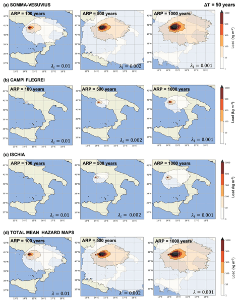
A new methodology to calculate a probabilistic long-term tephra fallout hazard assessment in southern Italy from the Neapolitan volcanoes is provided. By means of thousands of numerical simulations we quantify the mean annual frequency with which the tephra load at the ground exceeds critical thresholds in 50 years. The output hazard maps account for changes in eruptive regimes of each volcano and are also comparable with those of other natural disasters in which more sources are integrated.
Manuel Titos, Beatriz Martínez Montesinos, Sara Barsotti, Laura Sandri, Arnau Folch, Leonardo Mingari, Giovanni Macedonio, and Antonio Costa
Nat. Hazards Earth Syst. Sci., 22, 139–163, https://doi.org/10.5194/nhess-22-139-2022, https://doi.org/10.5194/nhess-22-139-2022, 2022
Short summary
Short summary
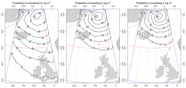
This work addresses a quantitative hazard assessment on the possible impact on air traffic of a future ash-forming eruption on the island of Jan Mayen. Through high-performance computing resources, we numerically simulate the transport of ash clouds and ash concentration at different flight levels over an area covering Iceland and the UK using the FALL3D model. This approach allows us to derive a set of probability maps explaining the extent and persisting concentration conditions of ash clouds.
Arnau Folch, Laura Sandri, Sara Barsotti, Simone Aguiar, Beatriz Martínez Montesinos, Alejandra Guerrero, Pablo Tierz, Heribert Pascual, Eva Hernandez, Leonardo Mingari, and Antonio Costa
EGUsphere, https://doi.org/10.5194/egusphere-2026-4485, https://doi.org/10.5194/egusphere-2026-4485, 2026
This preprint is open for discussion and under review for Natural Hazards and Earth System Sciences (NHESS).
Short summary
Short summary
Volcanic ash threatens communities near European volcanoes and aircraft across the continent. A new study has produced the first European hazard map for volcanic dispersal in the atmosphere, using more than 53,000 simulations of ash clouds from twelve European volcanoes, run on one of Europe's most powerful supercomputers. The results show where ash is likely to fall and which flight regions could be dangerous. Simulations are stored in an open catalogue that lets end-users update the hazard.
Carolina Díaz-Vecino, Jonathan Lemus, Allan Fries, Riccardo Simionato, Simon Thivet, Simona Scollo, Francesco Amadio, Laura Pioli, Alexandros Panagiotis Poulidis, Valentin Freret-Lorgeril, and Costanza Bonadonna
EGUsphere, https://doi.org/10.5194/egusphere-2026-4051, https://doi.org/10.5194/egusphere-2026-4051, 2026
This preprint is open for discussion and under review for Natural Hazards and Earth System Sciences (NHESS).
Short summary
Short summary
Ash fingers can form beneath volcanic clouds and transport volcanic ash differently from individual particles, yet their influence on ash dispersal remains poorly understood. Using field observations, ash samples, and simulations from the 23 July 2024 eruption of Mount Etna, this study shows that particle shape strongly controls ash transport and deposition, highlighting limitations in current volcanic ash forecasting models.
Riccardo Simionato, Allan Fries, Simon Thivet, Jonathan Lemus, Carolina Díaz-Vecino, Frederic Arlaud, Simona Scollo, and Costanza Bonadonna
EGUsphere, https://doi.org/10.5194/egusphere-2026-4353, https://doi.org/10.5194/egusphere-2026-4353, 2026
This preprint is open for discussion and under review for Geoscientific Instrumentation, Methods and Data Systems (GI).
Short summary
Short summary
We developed and tested an affordable, open-source camera system for long-term and temporary monitoring. Flexible settings, automated storage, and data transfer allow it to meet varied needs and operate in remote or harsh environments. Tests at volcanoes and in the laboratory showed reliable performance and enabled measurements of lava flows, volcanic plumes, and rapid processes. The system could broaden visual monitoring at less-monitored sites and support other environmental applications.
Alessandro Tadini, Andrea Bevilacqua, Mattia de' Michieli Vitturi, Emmie M. Bonilauri, Andrew J. L. Harris, Matteo Cerminara, Tomaso Esposti Ongaro, Augusto Neri, Raphaël Paris, Marco Pistolesi, Matteo Trolese, Juan F. Rodríguez-Gálvez, Daniele Andronico, Antonella Bertagnini, Sonia Calvari, Daniele Casalbore, Michael Cassidy, Riccardo Civico, Elisabetta Del Bello, Alessio Di Roberto, Alessandro Fornaciai, Anita Grezio, Lucia Gurioli, Carl B. Harbitz, Giorgio Lacanna, Finn Løvholt, Michael Marani, Massimo Pompilio, Tullio Ricci, Mauro Rosi, Laura Sandri, Roger Urgeles, and Marija Voloschina
EGUsphere, https://doi.org/10.5194/egusphere-2026-1310, https://doi.org/10.5194/egusphere-2026-1310, 2026
Short summary
Short summary
This study examines tsunami hazards linked to volcanic activity at Stromboli volcano, Italy and is aimed at developing a first Probabilistic Tsunami Hazard Assessment. In particular, in this study a review identified 16 tsunamis (1879–2024), mostly linked to paroxysmal eruptions. Expert elicitation suggests tsunamigenic landslides may recur every 10–12 years, with high likelihood along the Sciara del Fuoco, especially at mid-elevations and moderate volumes, informing future hazard assessment.
Anna Kampouri, Vassilis Amiridis, Thanasis Georgiou, Stavros Solomos, Anna Gialitaki, Maria Tsichla, Michael Rennie, Simona Scollo, and Prodromos Zanis
Atmos. Chem. Phys., 25, 7343–7368, https://doi.org/10.5194/acp-25-7343-2025, https://doi.org/10.5194/acp-25-7343-2025, 2025
Short summary
Short summary
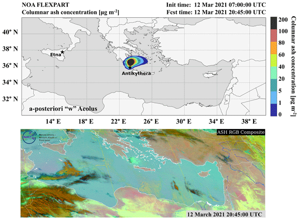
This study proposes a novel inverse modeling framework coupled with remote sensing data for improving volcanic ash dispersion forecasts, essential for aviation safety. By integrating FLEXPART dispersion model outputs with ground-based ACTRIS lidar observations, the approach estimates Etna's volcanic particle emissions and highlights a significant enhancement in the forecast accuracy.
Simon Thivet, Gholamhossein Bagheri, Przemyslaw M. Kornatowski, Allan Fries, Jonathan Lemus, Riccardo Simionato, Carolina Díaz-Vecino, Eduardo Rossi, Taishi Yamada, Simona Scollo, and Costanza Bonadonna
Atmos. Meas. Tech., 18, 2803–2824, https://doi.org/10.5194/amt-18-2803-2025, https://doi.org/10.5194/amt-18-2803-2025, 2025
Short summary
Short summary
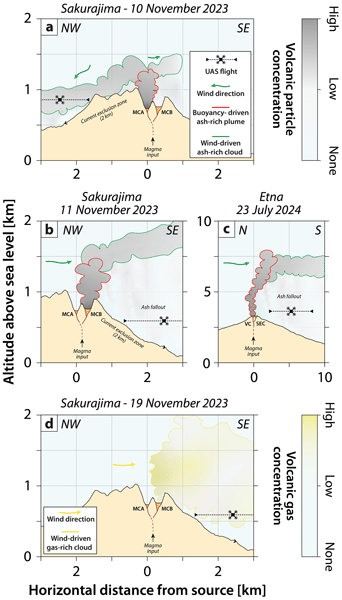
This work presents an innovative way of sampling and analyzing volcanic clouds using an unoccupied aircraft system (UAS). The UAS can reach hazardous environments to sample volcanic particles and measure in situ key parameters, such as the atmospheric concentration of volcanic aerosols and gases. Acquired data bridge the gap between the existing approaches of ground sampling and remote sensing, thereby contributing to the understanding of volcanic cloud dispersion and impact.
Luigi Mereu, Manuel Stocchi, Alexander Garcia, Michele Prestifilippo, Laura Sandri, Costanza Bonadonna, and Simona Scollo
Nat. Hazards Earth Syst. Sci., 25, 1943–1962, https://doi.org/10.5194/nhess-25-1943-2025, https://doi.org/10.5194/nhess-25-1943-2025, 2025
Short summary
Short summary
By considering the quantification of tephra mass deposited on roads following an eruption (or a series of explosive volcanic eruptions), in this work we assessed the cumulated tephra mass on the road networks in three selected towns on Mt Etna’s eastern flank during several paroxysms in 2021. This is a first attempt to estimate the amount of tephra that must be removed during a crisis that could be reused, converting in this way a potential problem into an opportunity.
Laura Sandri, Alexander Garcia, Cristina Proietti, Stefano Branca, Gaetana Ganci, and Annalisa Cappello
Nat. Hazards Earth Syst. Sci., 24, 4431–4455, https://doi.org/10.5194/nhess-24-4431-2024, https://doi.org/10.5194/nhess-24-4431-2024, 2024
Short summary
Short summary
In this paper we propose a probability map that shows where most likely future flank eruptions will occur at Etna volcano (in Sicily, Italy). The map updates previous studies since it is based on a much longer record of past flank eruption fissures that opened in the last 4000 years on Etna. We also propose sensitivity tests to evaluate how much the assumptions made change the final probability evaluation.
Laura Sandri, Mattia de' Michieli Vitturi, Antonio Costa, Mauro Antonio Di Vito, Ilaria Rucco, Domenico Maria Doronzo, Marina Bisson, Roberto Gianardi, Sandro de Vita, and Roberto Sulpizio
Solid Earth, 15, 459–476, https://doi.org/10.5194/se-15-459-2024, https://doi.org/10.5194/se-15-459-2024, 2024
Short summary
Short summary
We study the lahar hazard due to the remobilization of tephra deposits from reference eruptions at Somma–Vesuvius. To this end, we rely on the results of two companion papers dealing with field data and model calibration and run hundreds of simulations from the catchments around the target area to capture the uncertainty in the initial parameters. We process the simulations to draw maps of the probability of overcoming thresholds in lahar flow thickness and dynamic pressure relevant for risk.
Mattia de' Michieli Vitturi, Antonio Costa, Mauro A. Di Vito, Laura Sandri, and Domenico M. Doronzo
Solid Earth, 15, 437–458, https://doi.org/10.5194/se-15-437-2024, https://doi.org/10.5194/se-15-437-2024, 2024
Short summary
Short summary
We present a numerical model for lahars generated by the mobilization of tephra deposits from a reference size eruption at Somma–Vesuvius. The paper presents the model (pyhsics and numerics) and a sensitivity analysis of the processes modelled, numerical schemes, and grid resolution. This work provides the basis for application to hazard quantification for lahars in the Vesuvius area. To this end, we rely on results of the two companion papers (Part 1 on field data, Part 3 on hazard maps).
Mauro Antonio Di Vito, Ilaria Rucco, Sandro de Vita, Domenico Maria Doronzo, Marina Bisson, Mattia de' Michieli Vitturi, Mauro Rosi, Laura Sandri, Giovanni Zanchetta, Elena Zanella, and Antonio Costa
Solid Earth, 15, 405–436, https://doi.org/10.5194/se-15-405-2024, https://doi.org/10.5194/se-15-405-2024, 2024
Short summary
Short summary
We study the distribution of two historical pyroclastic fall–flow and lahar deposits from the sub-Plinian Vesuvius eruptions of 472 CE Pollena and 1631. The motivation comes directly from the widely distributed impact that both the eruptions and lahar phenomena had on the Campanian territory, not only around the volcano but also down the nearby Apennine valleys. Data on about 500 stratigraphic sections and modeling allowed us to evaluate the physical and dynamical impact of these phenomena.
Silvia Massaro, Manuel Stocchi, Beatriz Martínez Montesinos, Laura Sandri, Jacopo Selva, Roberto Sulpizio, Biagio Giaccio, Massimiliano Moscatelli, Edoardo Peronace, Marco Nocentini, Roberto Isaia, Manuel Titos Luzón, Pierfrancesco Dellino, Giuseppe Naso, and Antonio Costa
Nat. Hazards Earth Syst. Sci., 23, 2289–2311, https://doi.org/10.5194/nhess-23-2289-2023, https://doi.org/10.5194/nhess-23-2289-2023, 2023
Short summary
Short summary
A new methodology to calculate a probabilistic long-term tephra fallout hazard assessment in southern Italy from the Neapolitan volcanoes is provided. By means of thousands of numerical simulations we quantify the mean annual frequency with which the tephra load at the ground exceeds critical thresholds in 50 years. The output hazard maps account for changes in eruptive regimes of each volcano and are also comparable with those of other natural disasters in which more sources are integrated.
Manuel Titos, Beatriz Martínez Montesinos, Sara Barsotti, Laura Sandri, Arnau Folch, Leonardo Mingari, Giovanni Macedonio, and Antonio Costa
Nat. Hazards Earth Syst. Sci., 22, 139–163, https://doi.org/10.5194/nhess-22-139-2022, https://doi.org/10.5194/nhess-22-139-2022, 2022
Short summary
Short summary
This work addresses a quantitative hazard assessment on the possible impact on air traffic of a future ash-forming eruption on the island of Jan Mayen. Through high-performance computing resources, we numerically simulate the transport of ash clouds and ash concentration at different flight levels over an area covering Iceland and the UK using the FALL3D model. This approach allows us to derive a set of probability maps explaining the extent and persisting concentration conditions of ash clouds.
Hugues Brenot, Nicolas Theys, Lieven Clarisse, Jeroen van Gent, Daniel R. Hurtmans, Sophie Vandenbussche, Nikolaos Papagiannopoulos, Lucia Mona, Timo Virtanen, Andreas Uppstu, Mikhail Sofiev, Luca Bugliaro, Margarita Vázquez-Navarro, Pascal Hedelt, Michelle Maree Parks, Sara Barsotti, Mauro Coltelli, William Moreland, Simona Scollo, Giuseppe Salerno, Delia Arnold-Arias, Marcus Hirtl, Tuomas Peltonen, Juhani Lahtinen, Klaus Sievers, Florian Lipok, Rolf Rüfenacht, Alexander Haefele, Maxime Hervo, Saskia Wagenaar, Wim Som de Cerff, Jos de Laat, Arnoud Apituley, Piet Stammes, Quentin Laffineur, Andy Delcloo, Robertson Lennart, Carl-Herbert Rokitansky, Arturo Vargas, Markus Kerschbaum, Christian Resch, Raimund Zopp, Matthieu Plu, Vincent-Henri Peuch, Michel Van Roozendael, and Gerhard Wotawa
Nat. Hazards Earth Syst. Sci., 21, 3367–3405, https://doi.org/10.5194/nhess-21-3367-2021, https://doi.org/10.5194/nhess-21-3367-2021, 2021
Short summary
Short summary
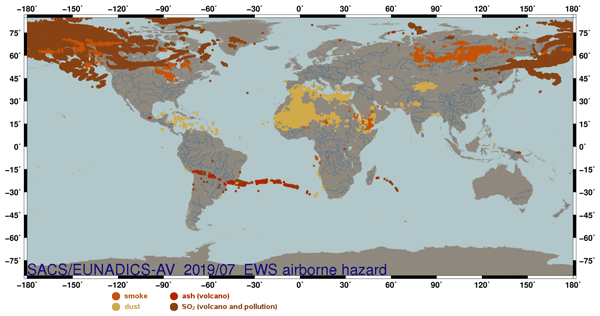
The purpose of the EUNADICS-AV (European Natural Airborne Disaster Information and Coordination System for Aviation) prototype early warning system (EWS) is to develop the combined use of harmonised data products from satellite, ground-based and in situ instruments to produce alerts of airborne hazards (volcanic, dust, smoke and radionuclide clouds), satisfying the requirement of aviation air traffic management (ATM) stakeholders (https://cordis.europa.eu/project/id/723986).
Cited articles
Akaike, H.: A new look at the statistical model identification, IEEE Trans. Automat. Contr., 19, 716–723, 1974. a
Al-Zoub, M. and al Rawi, M.: An Efficient Approach for Computing Silhouette Coefficients, J. Comput. Sci., 43, 252–255, https://doi.org/10.3844/jcssp.2008.252.255, 2008. a
Andronico, D., Scollo, S., Caruso, S., and Cristaldi, A.: The 2002–03 Etna explosive activity: tephra dispersal and features of the deposits, J. Geophys. Res.-Sol. Ea., 113, https://doi.org/10.1029/2007JB005126, 2008. a
Azzaro, R. and Neri, M.: L'attività eruttiva dell'Etna nel corso del ventennio 1971–1991, Primi passi verso la costituzione di un data-base relazionale, CNR IIV Open File Report, 3, 46, 1992. a
Behncke, B. and Neri, M.: Lava flow hazard at Mount Etna (Italy): new data from a GIS-based study, Geological Society Of America – Special Papers, 396, 189, https://doi.org/10.1130/0-8137-2396-5.189, 2005. a
Bonadonna, C., Connor, C. B., Houghton, B. F., Connor, L., Byrne, M., Laing, A., and Hincks, T. K.: Probabilistic modeling of tephra dispersal: Hazard assessment of a multiphase rhyolitic eruption at Tarawera, New Zealand, J. Geophys. Res., 110, B03203, https://doi.org/10.1029/2003JB002896, 2005. a
Branca, S. and Abate, T.: Current knowledge of Etna's flank eruptions (Italy) occurring over the past 2500 years. From the iconographies of the XVII century to modern geological cartography, J. Volcanol. Geotherm. Res., 385, 159–178, 2019. a
Branca, S. and Vigliotti, L.: Finding of an historical document describing an eruption in the NW flank of Etna in July 1643 AD: timing, location and volcanic products, Bull. Volcanol., 77, 1–6, 2015. a
Branca, S., Coltelli, M., and Groppelli, G.: Geological evolution of a complex basaltic stratovolcano: Mount Etna, Ital. J. Geosci., 130, 306–317, 2011a. a
Branca, S., Coltelli, M., Groppelli, G., and Lentini, F.: Geological map of Etna volcano, 1 : 50 000 scale, Ital. J. Geosci., 130, 265–291, https://doi.org/10.3301/IJG.2011.15, 2011b. a
Branca, S., Condomines, M., and Tanguy, J. C.: Flank eruptions of Mt. Etna during the Greek–Roman and Early Medieval periods: New data from 226Ra–230Th dating and archaeomagnetism, J. Volcanol. Geotherm. Res., 304, 265–271, 2015. a
Calvari, S. and Nunnari, G.: Comparison between Automated and Manual Detection of Lava Fountains from Fixed Monitoring Thermal Cameras at Etna Volcano, Italy, Remote Sens., 14, 2392, https://doi.org/10.3390/rs14102392, 2022. a, b, c
Calvari, S., Cannavò, F., Bonaccorso, A., Spampinato, L., and Pellegrino, A. G.: Paroxysmal Explosions, Lava Fountains and Ash Plumes at Etna Volcano: Eruptive Processes and Hazard Implications, Front. Earth Sci., 6, 107, https://doi.org/10.3389/feart.2018.00107, 2018. a, b, c
Corradini, S., Guerrieri, L., Lombardo, V., Merucci, L., Musacchio, M., Prestifilippo, M., Scollo, S., Silvestri, M., Spata, G., and Stelitano, D.: Proximal Monitoring of the 2011–2015 Etna Lava Fountains Using MSG-SEVIRI Data, Geosciences, 8, 140, https://doi.org/10.3390/geosciences8040140, 2018. a
Garcia-Aristizabal, A., Marzocchi, W., and Fujita, E.: A Brownian model for recurrent volcanic eruptions: an application to Miyakejima volcano (Japan), B. Volcanol., 74, 545–558, https://doi.org/10.1007/s00445-011-0542-4, 2012. a, b
Guest, J. E. and Murray, J. B.: An analysis of hazard from Mount Etna volcano, J. Geol. Soc., 136, 347–354, https://doi.org/10.1144/gsjgs.136.3.0347, 1979. a, b
Kagan, Y. Y. and Knopoff, L.: Statistical short-term earthquake prediction, Science, 236, 1563–1567, https://doi.org/10.1126/science.236.4808.1563, 1987. a
Kaufman, L. and Rousseeuw, P. J.: Finding Groups in Data, John Wiley & Sons, Inc., ISBN 9780470316801, https://doi.org/10.1002/9780470316801.ch2, 2008. a
Marzocchi, W. and Zaccarelli, L.: A quantitative model for time-size distribution of eruptions, J. Geophys. Res., 111, https://doi.org/10.1029/2005JB003709, 2006. a
Matthews, M. V., Ellsworth, W. L., and Reasenberg, P. A.: A Brownian Model for Recurrent Earthquakes, B. Seismol. Soc. Am., 92, 2233–2250, https://doi.org/10.1785/0120010267, 2002. a, b, c
Mereu, L., Scollo, S., Garcia, A., Sandri, L., Bonadonna, C., and Marzano, F. S.: A New Radar-Based Statistical Model to Quantify Mass Eruption Rate of Volcanic Plumes, Geophys. Re. Lett., https://doi.org/10.1029/2022GL100596, 2023. a, b, c, d
Mereu, L., Stocchi, M., Garcia, A., Prestifilippo, M., Sandri, L., Bonadonna, C., and Scollo, S.: Estimating the mass of tephra accumulated on roads to best manage the impact of volcanic eruptions: the example of Mt Etna, Italy, Nat. Hazards Earth Syst. Sci., 25, 1943–1962, https://doi.org/10.5194/nhess-25-1943-2025, 2025. a
Passarelli, L., Sansò, B., Sandri, L., and Marzocchi, W.: Testing forecasts of a new Bayesian time-predictable model of eruption occurrence, J. Volcanol. Geotherm. Res., 198, 57–75, https://doi.org/10.1016/j.jvolgeores.2010.08.011, 2010. a, b
Proietti, C. and Branca, S.: Dataset of Etna's flank eruptive fissures of the last 4000 years, Zenodo [data set], https://doi.org/10.5281/zenodo.14284932, 2024. a, b, c, d
Romano, R., Lentini, F., and Sturiale, C.: Carta geologica del Monte Etna: Geological map of Mt. Etna, in: Progetto finalizzato Geodinamica, Instituto internazionale di vulcanologia, edited by: Cartografica, L. A., Consiglio nazionale delle ricerche (Italy), Catania, 1979. a
Rousseeuw, P. J.: Silhouettes: A graphical aid to the interpretation and validation of cluster analysis, J. Comput. Appl. Math., 20, 53–65, https://doi.org/10.1016/0377-0427(87)90125-7, 1987. a
Sandri, L., Garcia, A., Proietti, C., Branca, S., Ganci, G., and Cappello, A.: Where will the next flank eruption at Etna occur? An updated spatial probabilistic assessment, Nat. Hazards Earth Syst. Sci., 24, 4431–4455, https://doi.org/10.5194/nhess-24-4431-2024, 2024. a
Sandri, L., Garcia, A., Scollo, S., and Mereu, L.: OTETNA: Onset Times of eruptive events at ETNA (flank eruptions since 1600 CE, summit paroxysms from 1986 to 2022 CE) (Version 1), Istituto Nazionale di Geofisica e Vulcanologia (INGV) [data set], https://doi.org/10.13127/etna/otetna, 2025. a
Sartorius Von Waltershausen, W.: Atlas des Aetna (v. 1), vol. 1–8, Weimar 9, edited by: Schmidt, S., Geografisches Institut, Berlin, 1848–1861. a
Scollo, S., Prestifilippo, M., Spata, G., D'Agostino, M., and Coltelli, M.: Monitoring and forecasting Etna volcanic plumes, Nat. Hazards Earth Syst. Sci., 9, 1573–1585, https://doi.org/10.5194/nhess-9-1573-2009, 2009. a
Scollo, S., Coltelli, M., Bonadonna, C., and Del Carlo, P.: Tephra hazard assessment at Mt. Etna (Italy), Nat. Hazards Earth Syst. Sci., 13, 3221–3233, https://doi.org/10.5194/nhess-13-3221-2013, 2013. a
Scollo, S., Bonadonna, C., Garcia, A., Mereu, L., Prestifilippo, M., Romeo, F., Sandri, L., and Stocchi, M.: New developments in the estimation of tephra fallout hazard at Mt. Etna, in Italy, during the PANACEA project, Ann. Geophys., 68, V102, https://doi.org/10.4401/ag-9174, 2025. a
Selva, J., Sandri, L., Taroni, M., Sulpizio, R., Tierz, P., and Costa, A.: A simple two-state model interprets temporal modulations in eruptive activity and enhances multivolcano hazard quantification, Sci. Adv., 8, eabq4415, https://doi.org/10.1126/sciadv.abq4415, 2022. a
Tonini, R., Sandri, L., and Thompson, M. A.: PyBetVH: A Python tool for probabilistic volcanic hazard assessment and for generation of Bayesian hazard curves and maps, Comput. Geosci., 79, 38–46, https://doi.org/10.1016/j.cageo.2015.02.017, 2015. a, b
Xu, R. and Wunsch, D. I.: Survey of clustering algorithms, IEEE T. Neural Networ., 16, 645–678, 2005. a
Zeimbekakis, A., Schifano, E. D., and Yan, J.: On Misuses of the Kolmogorov–Smirnov Test for One-Sample Goodness-of-Fit, Am. Stat., 78, 481–487, https://doi.org/10.1080/00031305.2024.2356095, 2024. a
Short summary
We model how eruptive events occur in time at Mt Etna. We distinguish between eruptions from flank fissures and paroxysmal eruptions from the summit craters. Our model allows to compute the expected annual frequency of flank events and the expected number of summit paroxysms in a future period of time, with uncertainty estimates. We show how this model can improve the assessment of probabilistic hazard from these eruptions.
We model how eruptive events occur in time at Mt Etna. We distinguish between eruptions from...


Altmetrics
Final-revised paper
Preprint