
the Creative Commons Attribution 4.0 License.
the Creative Commons Attribution 4.0 License.
 | 02 Nov 2026
Review article: rainfall-induced landslide early warning systems through the lens of the early warnings for all framework – advances, gaps, and perspectives
Roquia Salam

Bayes Ahmed
Peter Sammonds
This review is necessary to provide a comprehensive evaluation of rainfall-induced landslide early warning systems (LEWS) through the lens of the United Nations “Early Warnings for All” (EW4All) framework. This study integrates EW4All pillars, examines information sharing in academic publications and official websites/portals, and evaluates the global feasibility of implementing EW4All for LEWS. Of 45 rainfall-induced systems, 27 (26 LEWS and one forecasting-focused system) were found operational (benefiting 19 countries), meaning they were implemented and actively used for warning purposes when this paper was prepared. Some forecasting-focused systems were misleadingly described as early warning systems. Among Local, Regional and National systems, Local systems were often less scalable and more resource-intensive. Operational systems were mainly National, followed by Regional. Most operational systems relied on rainfall thresholds. Some included susceptibility maps; risk maps were largely absent. Real-time sensor data were used in some systems; however, high maintenance costs limited scalability. Reliability was further constrained by data scarcity, limited forecast verification, and suboptimal use of Artificial Intelligence. Community engagement was infrequently documented in the reviewed systems. Although EW4All is transformative, implementing effective LEWS across rainfall-induced landslide-prone areas worldwide by 2027 remains impractical without localised approaches, sufficient funding, community engagement, and enhanced institutional capacity.
- Article
(9598 KB) - Full-text XML
- BibTeX
- EndNote


1.1 The early warnings for all (EW4All) framework
Several initiatives have been undertaken since 1989 to develop effective early warning system(s) (EWS), with the aim of minimising human suffering and disruption (Fig. 1). The first global effort towards disaster risk reduction (DRR) began in 1989, when the United Nations (UN) declared the “International Decade for Natural Disaster Reduction” (IDNDR) (1990–1999) to enhance DRR activities.
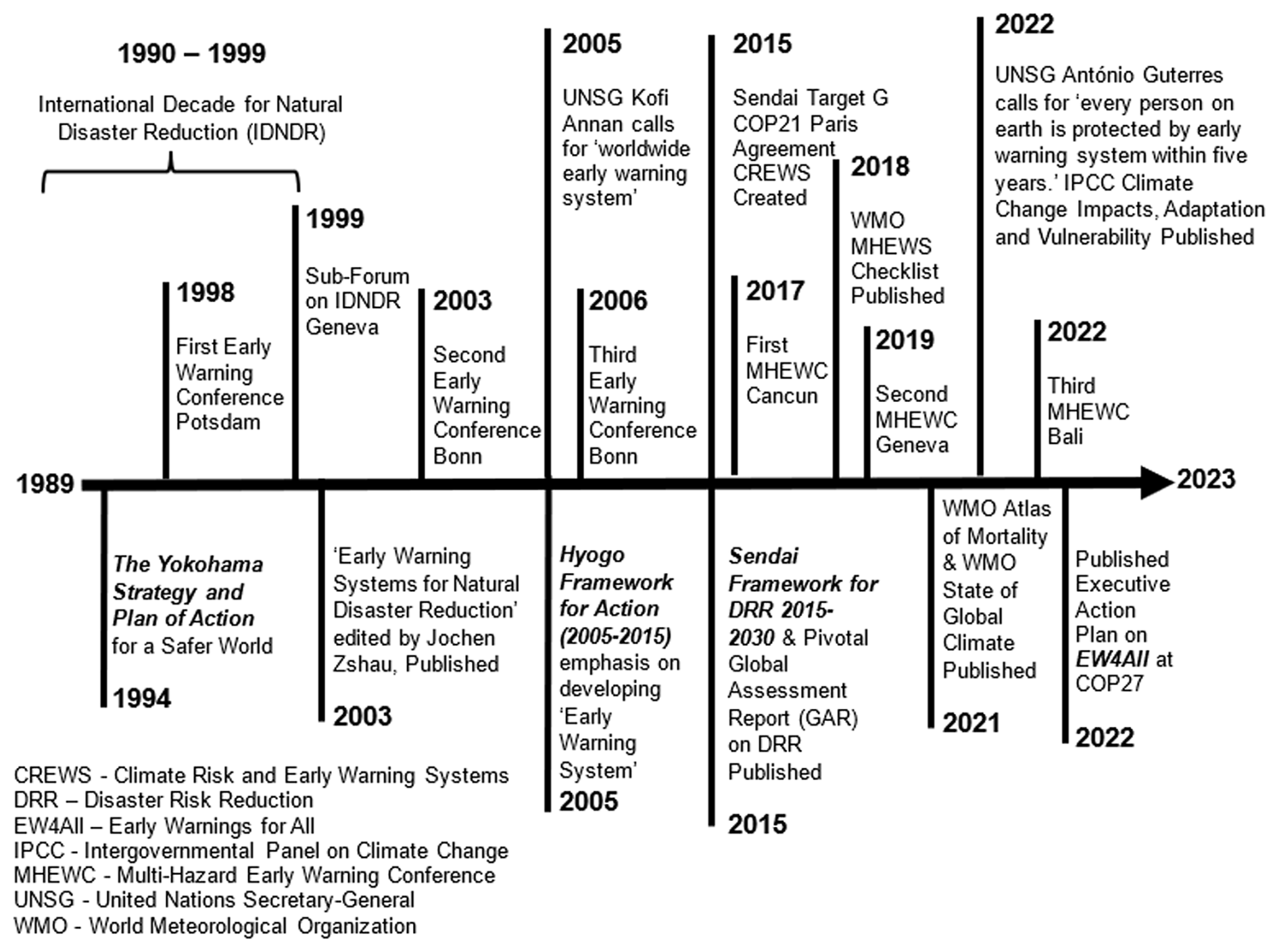
Figure 1A brief history of events, publications, announcements, and other milestones in the development of early warning systems from 1989 to the present day [Figure modified after UN (2023)].
During the IDNDR, the first landmark international guidance and framework for DRR, the “Yokohama Strategy and Plan of Action for a Safer World” was launched in 1994. Under the principles of this framework, early warning (EW) was identified as a key factor in effective disaster prevention and preparedness activities (UNISDR, 1994). However, EW was still a nascent concept within this framework, which lacked a detailed and clearly defined mechanism for EWS implementation (UNISDR, 2005). The tragic catastrophe of the Indian Ocean tsunami in December 2004, which killed more than 230 000 people around the Indian Ocean (Lay, 2012), made the international DRR community realise that EWS could save thousands of lives (UNISDR, 2006). Consequently, soon after the tsunami, the first global blueprint for DRR, the “Hyogo Framework for Action (HFA) 2005–2015”, was adopted in January 2005 by the global DRR community.
Among the five priorities for action, Priority two was “identify, assess and monitor disaster risks and enhance early warning”, with an emphasis on developing an EWS (UNISDR, 2005). However, several limitations were identified (UNISDR, 2015), such as the HFA emphasising the development of sector-specific (single-hazard) rather than integrated (multi-hazard) EWS. Furthermore, the engagement of all sectors (e.g., public, private, civil, academia, and scientific) was not ensured. Moreover, the HFA lacked a people-centred EWS. The HFA also treated the EWS as a siloed system (which was not explicitly incorporated into disaster risk management plans and policies) that limits its effectiveness in addressing the causal (e.g., climate change, and unplanned urbanisation) and compounding (e.g., demographic change, and poor institutional capacity) factors of disaster risk. Additionally, the small island developing States (SIDS), least developed countries (LDCs), and landlocked developing countries (LLDCs) faced multifaceted challenges in securing financial, technical, and institutional resources. These limitations of the HFA led to the adoption of a more comprehensive framework for DRR, the “Sendai Framework for Disaster Risk Reduction (2015–2030)”, in 2015 (UNISDR, 2015). While people-centred multi-hazard EWS (MHEWS) are emphasised in the Sendai Framework under Target G, the implementation of MHEWS has remained slow and uneven under this policy framework. In 2022, it was reported that only half of the countries worldwide were covered by MHEWS (UNDRR and WMO, 2022). Therefore, a more targeted initiative to accelerate the operationalisation of the MHEWS in line with Target G was launched in 2022, known as Early Warnings for All (EW4All) (UN, 2023).
EW4All is a groundbreaking initiative, and its main objective is to ensure that by the end of 2027, every human being on the planet is protected from hazardous weather, water, and climate events through timely warnings provided by EWS.
The EW4All initiative has three main targets, as follows (UN, 2023):
- i.
global coverage,
- ii.
multi-hazard impact-based EWS, and
- iii.
people-centred EWS.
Although EWS exist in some parts of the world, global coverage of these systems has not yet been ensured (UN, 2023). Some parts of the world remain without adequate EWS coverage, particularly LDCs and SIDS, with the situation being most severe in Africa (Guterres, 2022). Figure 2 portrays the UN-defined framework of people-centred multi-hazard early warning systems (MHEWS) for all (EW4All), comprising four pillars. Several organisations contribute to leading each pillar. EW4All has four pillars, as follows (UN, 2023):
-
Pillar 1: Disaster risk knowledge: Systematically collect data and undertake risk assessments.
-
Pillar 2: Detection, observation, monitoring, analysis, and forecasting: Develop hazard monitoring and early warning services.
-
Pillar 3: Warning dissemination and communication: Communicate risk information and early warnings.
-
Pillar 4: Preparedness and response capabilities: Build national and community response capabilities.
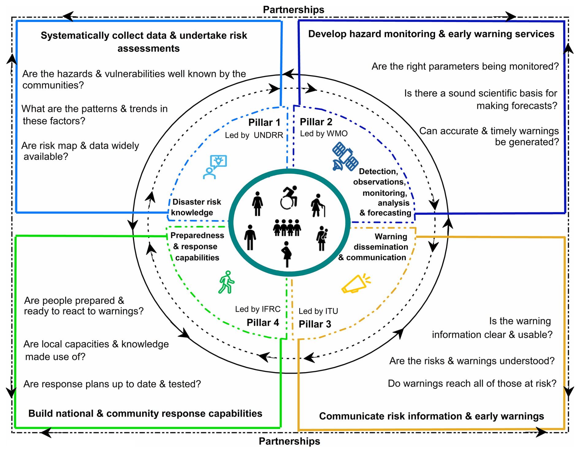
Figure 2UN defined four pillars of the people-centred multi-hazards EW4All framework [Figure slightly modified after UN (2023)].
1.2 The necessity of the early warning system
Since the UN initiated systematic efforts towards DRR activities in 1989, significant progress has been made (UN, 2023). However, increasing concentrations of human-induced greenhouse gases in the atmosphere have disrupted climatic and meteorological processes, contributing to increases in the intensity and frequency of extreme climate-related events (e.g., floods, landslides, droughts, cyclones, heatwaves, and others), which are expected to intensify further (IPCC, 2023). As the frequency of climatic extremes increases over time (Fig. 3), so does the number of people affected. Numerous adverse impacts, including death, injury, property damage, and loss of livelihoods, are recorded every day. Moreover, the environment is severely affected, creating conditions that may further exacerbate the risks associated with subsequent hazards. These extreme events may be associated with single or multiple hazards, thereby creating multi-hazard risk. This means that two or more hazardous events may occur in an area simultaneously (e.g., flash floods and landslides), or cumulatively (e.g., recurrent flash flooding), or sequentially (e.g., tropical storms and landslides), resulting in disproportionately severe impacts on people and property (Lee et al., 2024).
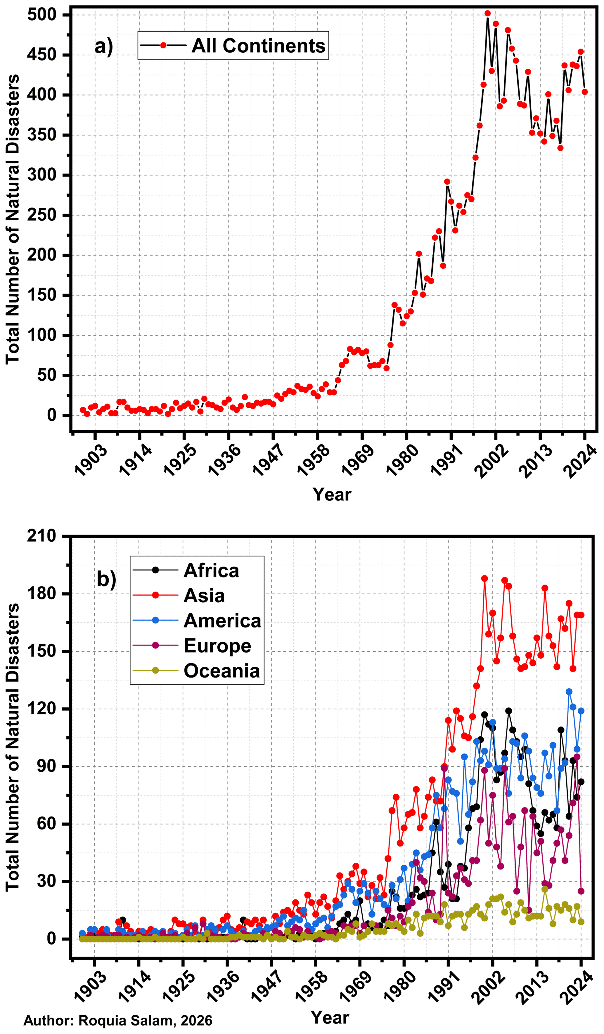
Figure 3Temporal trends in the total number of natural disasters between 1900 and 2024, (a) combined annual totals across all continents, and (b) continent-specific trends (Data source: EM-DAT (CRED, 2026)).
It is very challenging to reduce or avoid hazards completely; however, a recognised way to reduce their potential impacts is to ensure that people have access to EWS and, therefore, the opportunity to take appropriate anticipatory action before a hazardous event occurs. More specifically, an EWS is “an integrated system of hazard monitoring, forecasting and prediction, disaster risk assessment, communication and preparedness activities systems and processes that enables individuals, communities, governments, businesses and others to take timely action to reduce disaster risks in advance of hazardous events” (UNDRR, 2017). Some affected people have access to timely warnings through EWS, allowing them to prepare for upcoming events.
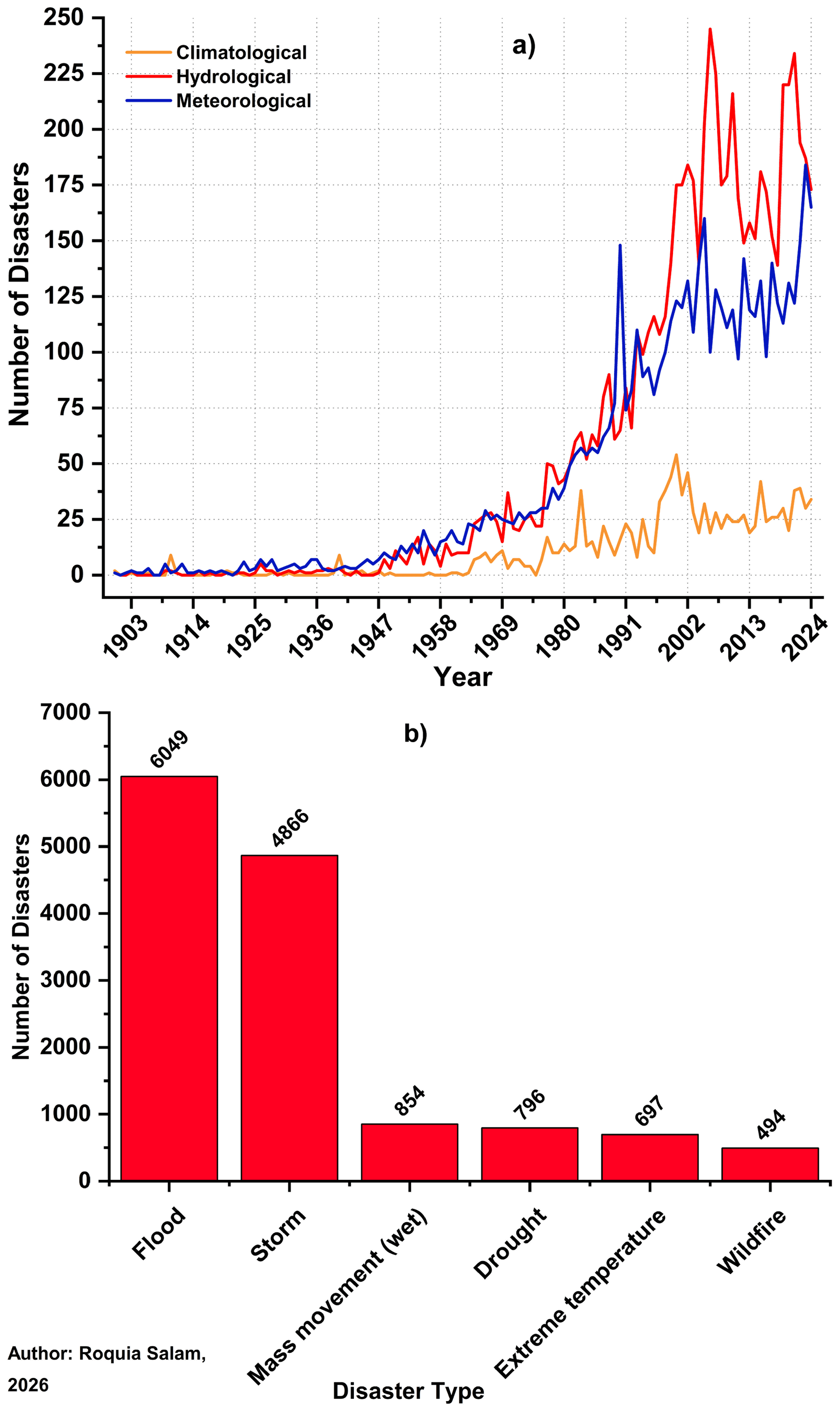
Figure 4(a) Temporal trends in the total number of climatological, hydrological, and meteorological disasters and (b) individual disaster types between 1900 and 2024 (Data source: EM-DAT (CRED, 2026)).
Moreover, rapid urbanisation has forced people in low- and middle-income countries to reside in vulnerable and hazardous areas, such as industrial areas, unstable slopes, and floodplains (Ozturk et al., 2022). These people are often economically marginalised and struggle to afford homes in safer and more stable areas due to higher land prices. As displacement increases, more and more people are migrating to urban areas, often settling in these vulnerable and hazardous locations. This contributes to a rapid increase in informal settlements characterised by low-quality housing materials, unstable political governance (Werthmann et al., 2024), inadequate road networks and drainage facilities, and other essential infrastructure. Therefore, during emergencies, people living in such areas are often unable to evacuate safely, increasing the potential for disastrous consequences. EWS are therefore particularly important for these communities to minimise potential loss and damage.
However, one-third of the world's population, especially those living in LDCs and SIDS, does not have access to timely and effective EWS that would enable them to prepare for upcoming hazardous events, resulting in increased loss and damage (UN, 2023). Hence, there is a need for EWS that can provide and disseminate timely warnings to all local communities, enabling them to take appropriate action to reduce impacts.
1.3 Why are rainfall-induced landslides a concern?
A significant upward trend is observed in the occurrence of hydrological disasters (Fig. 4a), and hydrological disasters account for about 90 % globally (Perera et al., 2019). Among these, rainfall-induced landslides (mass movement – wet) are identified as the third most frequently recorded disaster type among climatological, hydrological, and meteorological disasters globally, after floods and storms (Fig. 4b). Recent studies have shown that human activities such as construction, illegal hill cutting, and mining, largely associated with urbanisation, are increasingly contributing to fatal landslides (Alcántara-Ayala, 2025; Ozturk et al., 2022; Froude and Petley, 2018; Petley, 2009). Between 1998 and 2017, an estimated 4.8 million people were affected by landslides, resulting in more than 18 000 deaths (WHO, 2025). Therefore, the combined effects of climate change and rapid urban expansion are expected to increase landslide risk globally, leaving large numbers of people residing in informal settlements at higher risk (Werthmann et al., 2024; Ozturk et al., 2022). Despite their prevalence and significant social, economic, and environmental impacts, rainfall-induced landslides frequently receive less attention than more visibly catastrophic events such as floods, tsunamis, volcanic eruptions, and earthquakes (Guzzetti, 2021).
A landslide is the downslope movement of soil, rock, and organic materials under the influence of gravity, which occurs when the gravitational driving forces exceed the resistance of the slope-forming materials (Varnes, 1978).
Depending on the type of the movement, landslides are classified into six major categories as follows: flow, fall, topple, spread, slide, and complex (Varnes, 1978). Global inventories of fatal landslides covering 1995–2014 (Haque et al., 2019) and 2004–2016 (Froude and Petley, 2018) demonstrate a strong association between rainfall and fatal landslide occurrence. Froude and Petley (2018) reported that 79 % of non-seismic fatal landslide events were triggered by rainfall, while Haque et al. (2019) found that more than half of the recorded deadly landslide events occurred in areas exposed to extreme rainfall. The Intergovernmental Panel on Climate Change (IPCC) has reported that increased concentrations of greenhouse gases in the atmosphere are disrupting the global water cycle and, subsequently, intensifying extreme rainfall events that are unevenly distributed across the globe (Seneviratne et al., 2021). Extreme rainfall events cause slopes to become saturated with water, increasing pore water pressure and reducing slope stability, which may ultimately lead to slope failure. Landslides usually occur near weak points in slopes, such as joints, cracks, drainage channels, and fault lines of the slopes. Initial failures usually occur at these weak points, often triggered by factors such as rainfall and unplanned urbanisation, contributing to slope destabilisation. Such initial failures may further destabilise the slope, increasing its susceptibility to subsequent landslides. This process can create a feedback loop in which successive failures further weaken the slope and potentially contribute to additional and larger landslides in that area.
Landslide risk is associated with the interaction between exposure, hazard, and vulnerability. When an external hazard factor, such as rainfall, is coupled with high exposure in vulnerable areas, it can result in landslides of varying severity. Therefore, the current expansion of urban areas into vulnerable locations amplifies landslide risk in the absence of an adequate EWS. Landslides are often associated with compound or cascading hazards involving floods and storms; they also present specific challenges, particularly in relation to uncertainties, forecasting, communication, and governance. These challenges are further complicated by the fact that “landslides” is an umbrella term encompassing multiple landslide types, each posing its own challenges in the EW4All context. Although EWS have proven effective in reducing disaster impacts, the application of rainfall-induced landslide early warning system(s) (LEWS) remains geographically limited and fragmented (Guzzetti et al., 2020). Moreover, rainfall-induced LEWS are not always effective for several reasons, including the absence of risk-based mapping and community engagement, a lack of impact-based forecasting, and the absence of anticipatory action plans. Existing literature on LEWS provides information on rainfall thresholds, monitoring approaches, statistical modelling, and spatial scales. These contributions largely focus on forecasting. In particular, less attention has been given to operational and governance dimensions, including institutional responsibility, warning dissemination, community preparedness, response capacity, and implementation feasibility. Therefore, adopting the EW4All framework allows this review to reinterpret existing LEWS studies beyond technical performance and to assess the extent to which they address the wider requirements of effective early warning. An effective LEWS can contribute significantly to reducing potential loss and damage from rainfall-induced landslides; however, its effectiveness depends on wider risk reduction measures, including land-use planning, governance structures, exposure reduction, vulnerability reduction, and preparedness planning.
1.4 Novelty and originality
This study advances research on rainfall-induced LEWS by explicitly reframing the field within the UN EW4All framework. Although previous reviews have compared LEWS across local, regional, and national scales, they have generally focused on specific technical dimensions, such as thresholds, scale, or modelling approaches (Piciullo et al., 2018; Guzzetti et al., 2020). The distinct contribution of this review lies in its integrative and evaluative perspective, which considers LEWS through the EW4All pillars and assesses their implications for implementation. Rather than merely compiling published LEWS studies, this review reinterprets them through the operational and governance dimensions of EW4All, including institutional responsibility, warning dissemination, preparedness, response capability, and implementation feasibility. In addition, this review examines the extent to which LEWS-related information is shared in academic publications. Finally, it evaluates the feasibility of applying the EW4All framework, in its current form, to the development of LEWS worldwide. The novelty does not lie in identifying each individual technical or operational limitation for the first time; rather, it lies in examining how these established limitations interact across the complete warning chain represented by the EW4All framework.
Accordingly, the core objectives of this study are twofold: first, to identify the main challenges and areas requiring improvement in the development of rainfall-induced LEWS through the EW4All lens; and second, to assess the feasibility of applying the EW4All framework to the development of rainfall-induced LEWS globally by the end of 2027.
This literature review was conducted systematically, following predefined selection criteria. As the PRISMA 2020 methodology provides a standardised framework for identifying, screening, and selecting relevant studies, it was adopted in this study to select relevant articles and websites (Fig. 5). Articles were retrieved from five databases: Scopus, Web of Science, ScienceDirect, GeoRef, and the Institute of Electrical and Electronics Engineers (IEEE) Xplore. The LandAware catalogue, together with official government and agency websites/portals, was used to supplement the literature records. This supplementary grey-literature search was conducted in a targeted manner. These sources were used to verify the operational status of each system, collect evidence to inform the assessment of Pillars 3 and 4, and identify operational LEWS that were not captured in the filtered literature. Only publicly available supplementary information meeting the defined language (English) criteria was utilised.
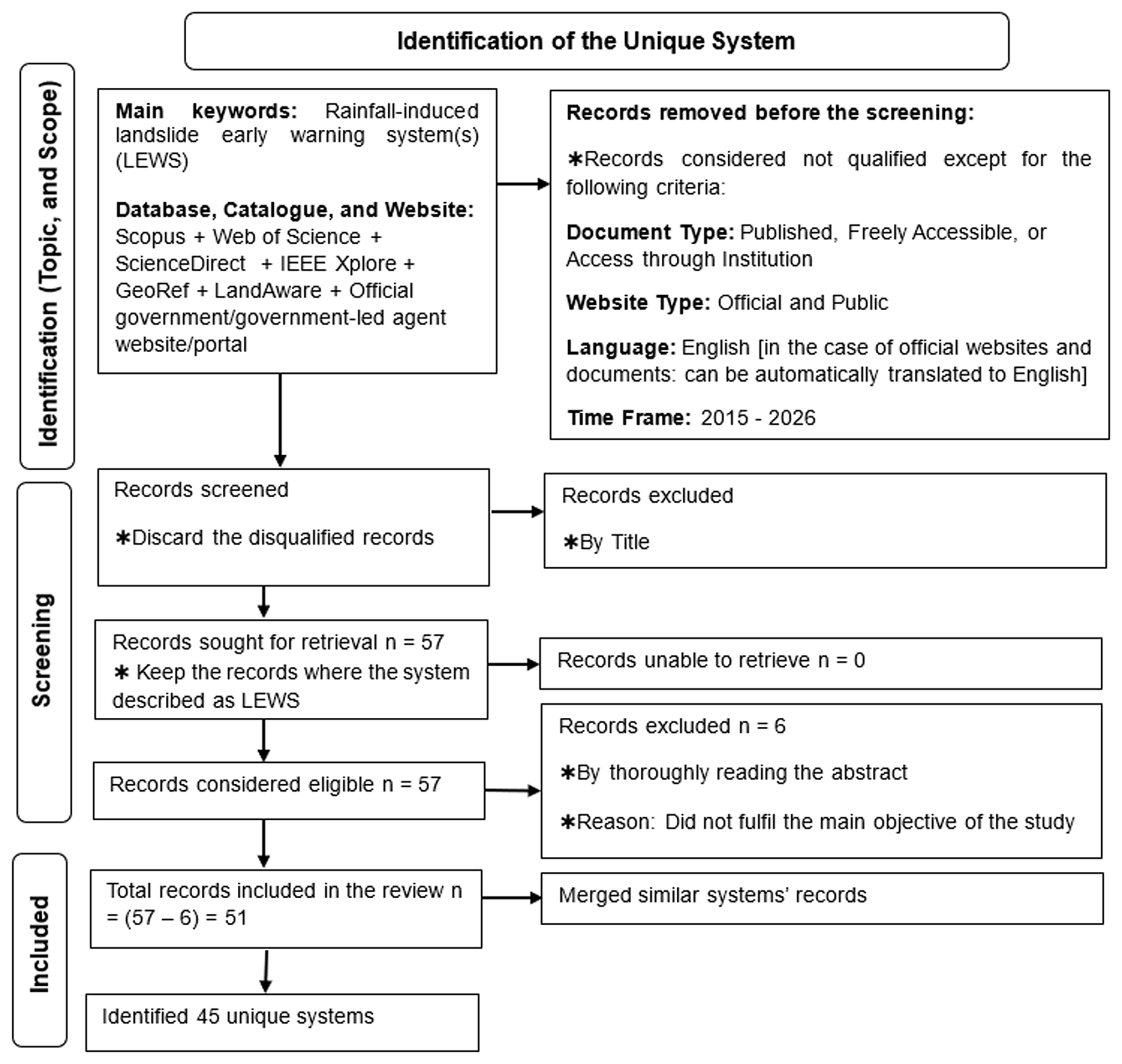
Figure 5In alignment with PRISMA 2020 methodology, the selection process was used to identify unique systems for inclusion in the literature review.
There is a clear distinction between “forecasting” and an “early warning system”. Forecasting is an integral component of EWS. Forecasting is a definite statement or statistical estimate of the likely occurrence of a future event or conditions for a specific area (UNISDR, 2009). However, EWS is an integrated system of hazard monitoring, forecasting and prediction, disaster risk assessment, communication and preparedness activities, systems and processes that enables stakeholders to take timely action to reduce disaster risk before hazardous events occur (UNDRR, 2017). In the published literature, many authors have used the term “EWS” to describe their work, although they discussed only the forecasting component. This review paper considers both articles in which LEWS (all pillars of landslide EWS were present) and forecasting-focused systems (only those where the systems were described as LEWS) were discussed. Therefore, the term “system” is used throughout this review to encompass records of both LEWS and forecasting-focused systems. A system classified as LEWS had evidence, from publications, official websites, portals, or blogs, of a complete EWS chain. A system classified as forecasting-focused lacked evidence of a complete EWS chain.
The search term used to search for the potential records was “Rainfall-induced landslide early warning systems”. Landslides can also be triggered by earthquakes. However, this review focused exclusively on rainfall-induced landslides. Therefore, systems addressing earthquake-induced landslides were excluded during the selection process.
Systems discussed in articles published between 2015 and 2026 were considered for this study. Therefore, systems with no relevant publication during this period were not included in the main dataset. This may have excluded some older but still operational systems. This approach enabled the review to focus on current published evidence, recent methodological and operational challenges, and the gap between what is reported in recent literature and what is required for a complete EW4All-aligned LEWS. Next, the screening process was initiated. After applying all the criteria specified in Fig. 5 and scrutinising the titles of the articles, documents, and websites, 57 records remained. Of these 57 records, six were subsequently excluded because they did not meet the main objective of this study. Finally, 51 system records were selected. Among these 51 records, multiple records describing the same system were merged. After this consolidation, a total of 45 unique systems were identified.
For each unique system, a structured data-extraction protocol was used to extract information on country; locality; areal coverage; system scale (National, Regional, or Local); system type (LEWS or Forecasting-focused); operational evidence; strength of the evidence (High or Moderate); Pillar 1 (P1) assignment source, Pillar 2 (P2) assignment source, Pillar 3 (P3) assignment source, and Pillar 4 (P4) assignment source; source of the pillar assignments; and references (Table A1). “High” strength was assigned where explicit information was provided in the relevant articles or official websites/portals. “Moderate” strength was assigned where explicit information was not found in the relevant articles or official websites/portals. “Operational” status was assigned to systems for which current routine warning dissemination was demonstrated, either in published literature or supplementary official blogs, portals, or websites. “Non-operational” status was assigned to systems for which current routine warning dissemination was not demonstrated. This category included systems that were designed, prototyped, experimentally tested, validated, or recommended for future implementation. Systems designed to monitor and disseminate warnings for a specific slope, site, catchment, or settlement were defined as “Local”. Systems designed to monitor and disseminate warnings for a subnational area, such as a municipality, city, district, province, or region, were defined as “Regional”. Systems designed to monitor and disseminate warnings for multiple landslide-prone regions or municipalities, or for an entire country, were defined as “National”.
In addition to technical and methodological considerations, LEWS development is strongly influenced by institutional ownership and operational responsibility. In many contexts, geological surveys or comparable technical agencies may lack either the continuous operational capacity required for warning services or the formal mandate to issue warnings. Consequently, LEWS may emerge through community-led initiatives or be developed by sector-specific actors, such as transport agencies, that face recurrent disruption from landslides. These forms of locally embedded practice are often insufficiently captured in academic publications. Yet, they are directly relevant to EW4All, whose implementation framework emphasises social inclusion, local engagement, and people-centred warning systems.
The information on the 45 systems presented in this section was derived exclusively from the referenced publications, websites, portals, and official blogs. Only details explicitly reported and supported by evidence from these supplementary sources were included. Where relevant information was not found, it was treated as not reported for that system in this analysis. Furthermore, because the study selection process involved several filtering stages, some potentially relevant publications may have been excluded. As a result, the plots and associated discussion may reflect some degree of missing or incomplete information. This limitation highlights an important aspect of global comparison. Some studies described technical forecasting methods in detail, while others provided limited information on institutional mandates, warning dissemination, preparedness actions, operational status, or community engagement. For this reason, comparisons among systems developed across different countries and scales may partly reflect differences in reporting practices, rather than solely differences in the actual performance or maturity of the systems.
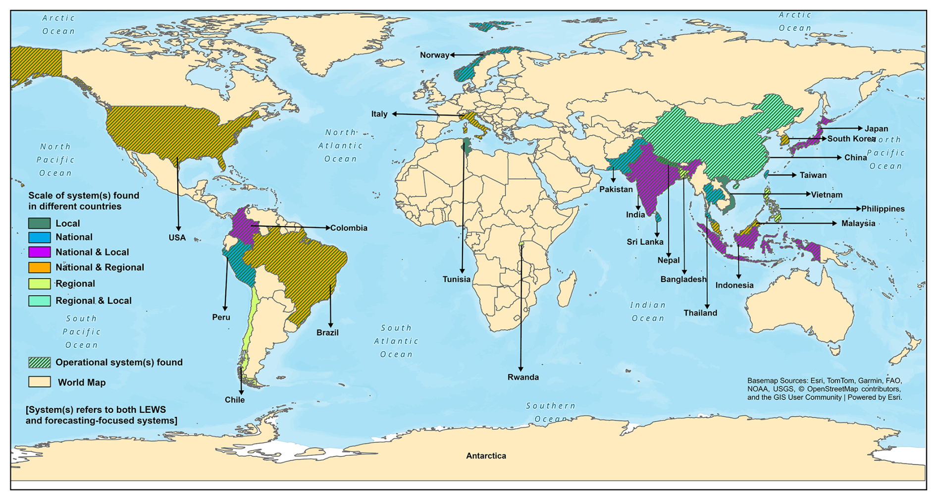
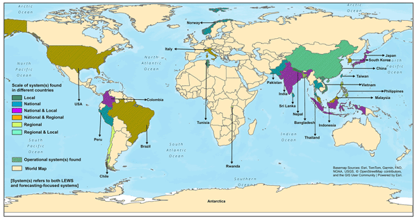
Figure 6Geographical distribution and scale of system(s) identified from the selected 45 systems.
3.1 Pillar 1: Landslide risk knowledge
The 45 unique systems covered 23 countries worldwide (Fig. 6, Table A1). Of these 45 systems, 33 were classified as LEWS, while the remaining 12 were classified as forecasting-focused (Table 1). LEWS accounted for six (46.2 %) of 13 Local systems, 12 (75.0 %) of 16 Regional systems, and 15 (93.75 %) of 16 National systems. Previous studies found that although there are operational National, Regional, or Local LEWS in some countries, many areas at very high risk of landslides, where loss and damage are substantial, remain uncovered by any of these LEWS (Guzzetti et al., 2020; Froude and Petley, 2018). LEWS that remain at the non-operational stage have been recommended by their authors for operational implementation (Liu et al., 2024; Guo et al., 2019). In such cases, these LEWS may not have been operationally implemented because of the limitations in effective coordination and collaboration among the relevant departments, agencies, or authorities.
Figure 7 shows the operational status of the 45 reviewed systems according to their spatial scale. Among the 45 systems, 27 were identified as operational, while the remaining 18 were identified as non-operational. A relatively balanced distribution of systems was observed across the three spatial scales: 16 National, 16 Regional, and 13 Local. However, operational status differed markedly across spatial scales within this sample. Only 15.4 % of Local systems were operational, compared with 56.25 % of Regional systems and 100 % of National systems. This distinction may indicate that most National systems benefit from established institutional mandates that support their operationalisation. Both National and Regional systems are comparatively more scalable and may be easier to sustain institutionally. Each slope is distinct because of its unique geological and geomorphological characteristics, which may require a tailored monitoring approach (Khan et al., 2021; Wieczorek and Snyder, 2009). Local LEWS are therefore often designed around site-specific monitoring strategies, with monitoring parameters and instruments selected according to the characteristics of the landslide being monitored (Pecoraro et al., 2019). Accordingly, some systems had been developed to focus on individual slopes; however, most remained at the non-operational stage. This may be partly because implementing a Local LEWS for a single community on a specific slope is not always economically feasible, as cost–benefit analyses may indicate that the associated costs outweigh the potential benefits (Sapena et al., 2023). Local systems require slope-specific instruments to be installed, along with continuous monitoring, calibration, maintenance, technical expertise, and secure funding. Therefore, although Local systems may provide highly localised and relevant landslide warnings, ensuring their scalability is difficult (Sapena et al., 2023). This highlights a major gap in the transition from the development of prototype systems to operational implementation. The scale comparison therefore reveals an operational trade-off between local accuracy and wider transferability rather than a simple hierarchy of system quality. Several systems (12) were developed primarily to demonstrate rainfall thresholds, monitoring approaches, or forecasting methods. For instance, only one forecasting-focused system, which operated at the National scale, was identified as operational. Local systems had a comparatively higher number of forecasting-focused systems (seven). However, making a system operational requires continuous data availability, maintenance funding, institutional responsibility, legal authority to issue warnings, adequate financial resources, skilled personnel, clear communication and response protocols, and an appropriate mandate (Krøgli et al., 2018). These requirements are not always considered or addressed in academic research. As a result, many developed systems remain at the prototype or experimental stage and are therefore classified as forecasting-focused, rather than being fully operational.
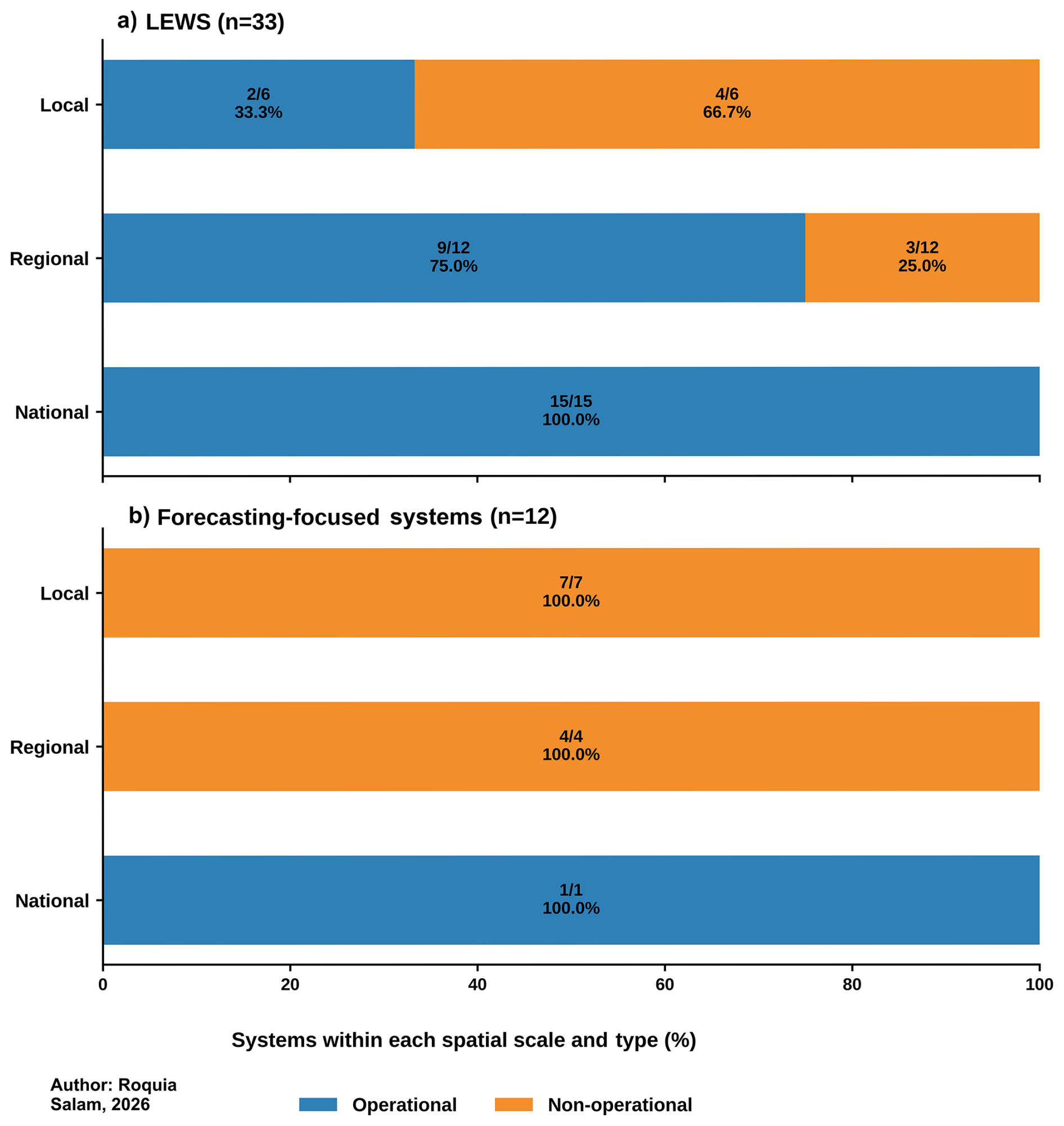
Figure 8 shows the uneven geographical distribution of the 45 systems. Among the 45 systems, 28 were in Asia, followed by seven in Europe, six in South America, two in Africa, and two in North America (Figs. 6, 8). A total of 14 systems (13 LEWS and one forecasting-focused) in Asia were operational, followed by seven in Europe (all LEWS), four in South America (all LEWS), none in Africa, and two in North America (both LEWS). These operational systems do not cover all landslide-affected areas within their respective countries; rather, most cover only parts of the landslide-affected zones (Table A1). The operational systems span 19 countries: Bangladesh, Brazil, Colombia, Hong Kong (China), India, Indonesia, Italy, Japan, Malaysia, Nepal, Norway, Pakistan, Peru, the Philippines, South Korea, Sri Lanka, Taiwan, Thailand, and the United States (Fig. 6, Table A1). Together, they provide EW coverage for only a small fraction of landslide-affected areas worldwide. However, this does not reflect a complete inventory of operational systems worldwide.
Most of the reviewed systems focused on shallow landslides and debris flows. Debris flow is one of the most destructive rainfall-induced landslides. It is observed from the selected systems (Table 1) that 25 systems used a static susceptibility map. Among them, 23 were categorised as LEWS (19 operational), and two were forecasting-focused (both non-operational). Of these 25 systems (55.6 % of the total sample), 19 (76 %) (comprising one Local, six Regional, and 12 National systems) were operational. However, among the 20 systems that did not integrate a susceptibility map, ten were forecasting-focused, while eight (40 %) systems (of them one Local and one forecasting-focused) were identified as operational. These descriptive results do not demonstrate that susceptibility mapping causes operationalisation.
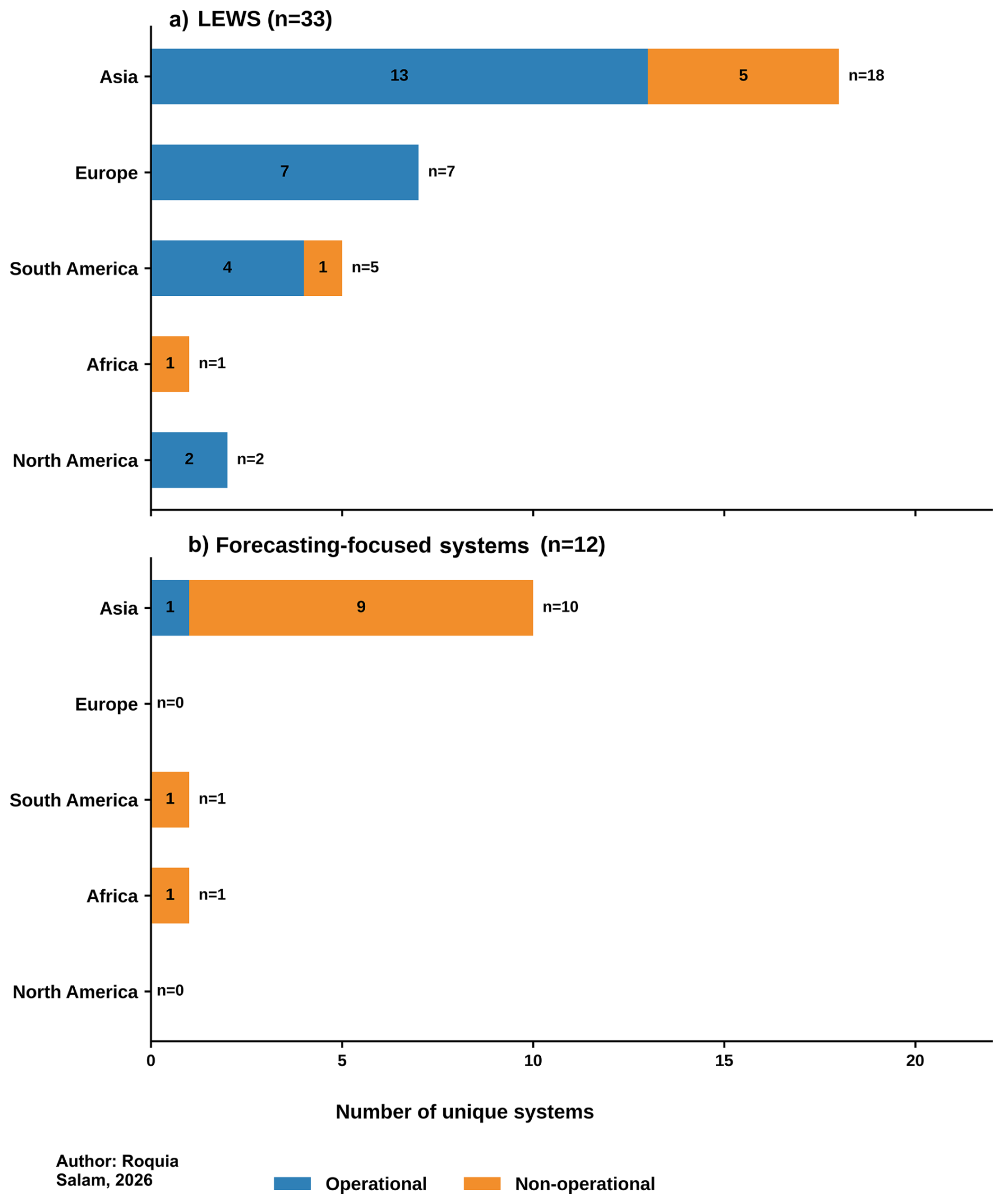
Figure 8Geographical distribution of the 45 systems, together with their operational status.
The uneven use of susceptibility maps indicates that some operational systems remain dominated by rainfall-threshold approaches. Rainfall thresholds are comparatively easier to develop, validate, and integrate into systems, particularly where other data, technical expertise, and institutional resources are limited. However, systems that integrate only rainfall thresholds may provide more generalised warnings, as they have a limited capacity to account for spatial variations in landslide susceptibility and risk. Landslide susceptibility levels vary considerably within a landslide-affected locality, area, or region. A susceptibility map can provide spatial information on landslide susceptibility across an area through susceptibility levels (e.g., very low, low, medium, high, very high) to indicate the relative likelihood of landslide occurrence in different locations (Azarafza et al., 2021). Therefore, incorporating a susceptibility map into Regional and National systems can enhance forecasting capability by enabling the prioritisation of specific high-risk zones for targeted EW, rather than providing generalised warnings across the entire affected area (Singh et al., 2024). This may help to reduce false alarms. Moreover, making susceptibility maps accessible to communities may support more informed and proactive preparedness measures.
Table 1Distribution of operational status and spatial scale across key system characteristics, stratified by system type.
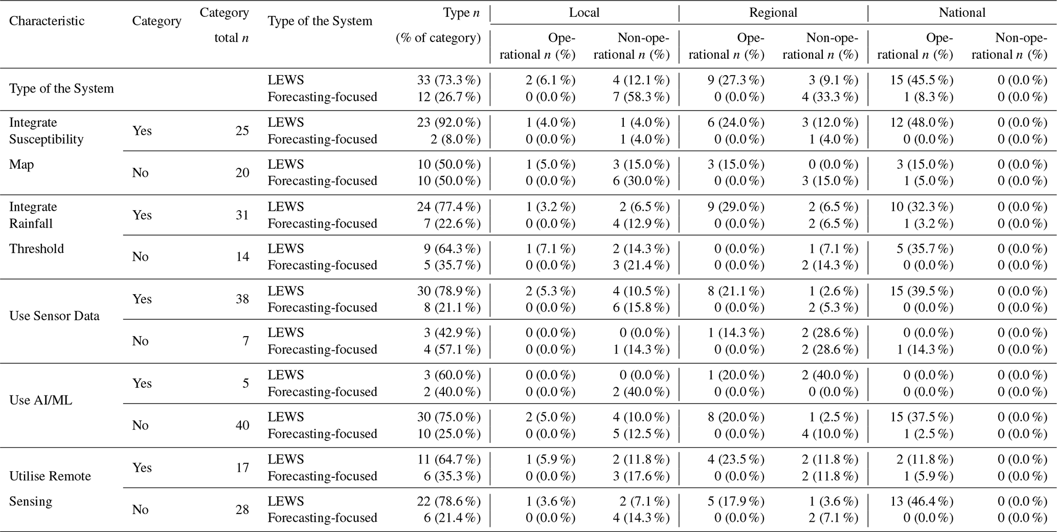
Note: Percentages in “Type n” are calculated using the corresponding characteristic-category total as the denominator. Percentages in the Local, Regional, and National columns use the same characteristic-category denominator. All values refer to the reviewed sample.
Additionally, susceptibility-based systems involve important trade-offs between accuracy, transferability, and operational scalability (Piciullo et al., 2018; Sapena et al., 2023). Local systems may not require a susceptibility map; however, they can generate more precise warnings for specific slopes. As Local systems require monitoring instruments, regular maintenance and updating, technical expertise, funding, and other resources, they may be less transferable (Sapena et al., 2023). However, National and Regional systems are more scalable and may be easier to operationalise. Therefore, susceptibility maps should be integrated into National and Regional systems to improve their capacity to issue more spatially targeted and reliable warnings. Without such integration, these systems may overlook important spatial variations in susceptibility and risk, reflecting a broader operational challenge in LEWS development. Therefore, having an accessible risk or susceptibility map is important to help communities understand the potential and spatially specific impacts of landslides on their livelihoods and resources, and to support appropriate preparedness measures (UNDRR and WMO, 2025).
3.2 Pillar 2: Landslide detection, observation, monitoring, analysis, and forecasting
After establishing an appropriate understanding of landslide risks, the next stage involves detection, observation, monitoring, analysis, and forecasting, which constitute the second pillar of the EW4All framework, led by the World Meteorological Organization (WMO). The elements incorporated into LEWS are important to examine, as selecting and integrating appropriate elements can improve the effectiveness and reliability of warnings (Calvello, 2017). From an operational perspective, the choice of monitoring strategy directly affects warning reliability, lead time, maintenance requirements, and the scalability of LEWS. Table 1 presents a comparison of the operational status of the selected systems and their key characteristics. Figure A1 provides supplementary information. The information shown in Table 1 and Fig. A1 should be interpreted as descriptive cross-tabulations only. The cross-tabulation indicates that technical availability and operational status vary markedly across spatial scales.
Reliable monitoring depends on sustained observations and data continuity. Rainfall monitoring was found to be the primary hydrometeorological trigger. A total of 31 out of 45 systems used a rainfall threshold. Among these 31 systems (including seven forecasting-focused systems), 21 (67.7 %) were operational (including one forecasting-focused system) (Table 1, Fig. A1). By contrast, among the 14 systems that did not integrate a rainfall threshold, six (42.9 %) were operational (none of which were forecasting-focused) (Table 1, Fig. A1). The scale-based pattern is also informative. Among the 31 systems that used a rainfall threshold, one Local system (out of seven), nine Regional systems (out of 13), and 11 National systems were operational. Among the 14 systems without a rainfall threshold, one Local system (out of six), none of the three Regional systems, and all five National systems were operational. This pattern indicates that integration of rainfall thresholds was more common among Regional and National systems. In this threshold calculation approach, both historical rainfall and past landslide data are used to identify a critical rainfall level associated with previous landslide occurrences (Satyaningsih et al., 2023). This critical rainfall level is defined as the threshold and subsequently used as a benchmark. Therefore, when rainfall is forecast to approach or exceed this threshold level, the system issues a warning indicating the potential occurrence of landslides. This threshold level is not the same everywhere in the world. It varies from country to country, region to region, place to place, and even from slope to slope (Barthélemy et al., 2024). Therefore, identifying the appropriate threshold level for the specific place or region is a crucial aspect of developing an effective and reliable system for that area (Harilal et al., 2019). However, thresholds developed for Local systems may have limited transferability (Harilal et al., 2019).
Field sensors were used in 38 of the 45 systems, eight of which were forecasting-focused, and none of these eight were operational. This indicates that in situ monitoring was one of the most common technical characteristics of the reviewed systems. A total of 25 (65.8 %) of these 38 systems were operational (Fig. A1). The cross-tabulation of operational status by spatial scale shows uneven sensor use among these 25 operational systems (Table 1). Two of the 12 Local systems, eight of the 11 Regional systems, and all 15 National systems were operational. The sensors used included rain gauges, piezometers1, inclinometers2, tilt sensors, displacement monitoring devices, and other instruments. Monitoring pore water pressure3 is important as it can decrease the soil's shear strength and slope stability. Pore water pressure can increase due to external factors such as rainfall, changes in drainage patterns, groundwater infiltration, and others. If a slope contains multiple groundwater tables at different depths, its stability may become more complex, and such conditions are not uncommon (Tang et al., 2020). If the soil becomes saturated, both pore water pressure and the overall weight of the soil increase. This can further reduce shear strength, creating favourable conditions for ground movement and potentially leading to slope failure (Wu et al., 2021). In this case, a piezometer is a useful tool for measuring the pore water pressure, while an inclinometer is used to detect ground movement. Therefore, integrating piezometers and inclinometers into the system can improve its reliability. However, these sensors can also involve high maintenance costs and generally provide measurements only at specific locations. Therefore, even a system covering a relatively small area may require multiple sensors to monitor pore water pressure and ground movement at different locations across the slopes. Thus, integrating piezometers and inclinometers into the LEWS may not be cost-effective for providing EW across a wider region, but may be more suitable for monitoring specific slopes or locations (Sapena et al., 2023). The predominance of non-operational local sensor-based systems in this review reinforces the distinction between technical monitoring capability and sustained operational implementation.
Artificial intelligence (AI) and machine learning (ML) were less commonly used, appearing in five out of 45 systems. Among these five systems, two were Local (both forecasting-focused and non-operational), and three were Regional. Only one of these three Regional systems was operational. No National system used AI/ML. However, this pattern does not indicate that the use of AI/ML reduces the performance of LEWS. AI/ML can be used extensively to fill data gaps, especially by integrating satellite remote sensing data (Pfeiffer et al., 2024). This makes AI an important tool for data-sparse regions where conventional ground-based observations are limited or unevenly distributed. It can also support pattern recognition, data integration, and susceptibility mapping. Thus, AI may improve the scalability of LEWS when implemented carefully. However, AI models generally require large volumes of high-quality data for training. In data-sparse regions, meeting this requirement is a major challenge. For instance, satellite-based detection is often hindered during the monsoon season due to cloud cover (Salam et al., 2024). Moreover, many AI models tend to overlook social and community dimensions, such as local knowledge, cultural contexts, and communication preferences, which are critical for effective early warning and community response. Although various categories of open-access global datasets are available for model training, every landslide setting is unique, and the characteristics of the triggering factors (e.g., vegetation, land use patterns, soil composition, hydrology, slope, and others) vary between landslide-prone areas. Therefore, using globally available datasets to train an AI model and applying the resulting model to another region may oversimplify local conditions, leading to inaccurate warnings (Patton et al., 2023; Pfeiffer et al., 2024). Thus, AI should be considered a complementary component of a hybrid LEWS, combined with expert interpretation, field validation, and institutional decision-making. Operational use also requires interpretable model outputs, transparent validation, clear communication of uncertainty, and human oversight. Poorly interpretable predictions may make it difficult for warning authorities to justify decisions, communicate uncertainty, and establish accountability (Pfeiffer et al., 2024).
Application programming interface(s) (API) were used in eight of the 45 systems, two of which were forecasting-focused and non-operational (Table A2). Of these eight systems, five (62.5 %) were operational, compared with 22 of the 37 systems without API integration (59.5 %), of which 21 were LEWS (Fig. A1, Table A2). This indicates that API use is not, by itself, a useful proxy for operational maturity. Spatially, the eight API-enabled systems comprised two Local, four Regional, and two National systems; one Local, two Regional, and both National systems were operational (Table A2). In some cases, an API is used to integrate data generated by external systems (Ofoeda et al., 2019). For instance, to develop a system dedicated to rainfall-induced landslides, forecast rainfall data are required to estimate the potential accumulated rainfall over the following day or days (Ahmed et al., 2018, 2020). This helps to determine whether rainfall is likely to exceed the threshold and to issue an EW for potential landslide events. Some dedicated institutions forecast rainfall at hourly or daily intervals using advanced statistical modelling. This forecast rainfall can then be integrated into the system through an API, potentially improving the timeliness and reliability of warnings (Krøgli et al., 2018).
IoT technology4 was used in seven systems (one forecasting-focused and non-operational), of which two (both LEWS) were operational (Table A2). Among these seven, six were Local (one operational), and one was Regional (operational). IoT has a direct role in enabling automated, real-time data transmission from dense, site-specific sensor networks. It provides an efficient means of immediately transmitting sensor measurements to the system through wireless communication, thereby enabling real-time monitoring (Liu et al., 2022). Remote sensing technology was used in 17 systems (six of which were forecasting-focused, with one of these being operational); eight (47.1 %) of the 17 systems were operational. However, among the remaining 28 systems (22 LEWS and six forecasting-focused) that did not use remote sensing, 19 were operational. Remote sensing is frequently adopted in research-oriented or recently developed systems, while its main operational advantages include broader spatial coverage and support for data-sparse areas (Pfeiffer et al., 2024). In the reviewed sample, all three National systems using remote sensing were operational, compared with four of eight Regional systems and one of six Local systems, indicating that the institutional context in which Earth observation is integrated remains important.
The findings indicate that National-scale LEWS were predominantly operational, whereas forecasting-focused systems were rarely operational, and the integration of susceptibility mapping was associated with a higher proportion of operational systems. No single technology was found to consistently predict operational status in this cross-tabulation analysis. Several apparent associations were also influenced by spatial scale and the distinction between LEWS and forecasting-focused systems. Operational maturity therefore appears to be more closely associated with institutional responsibility, routine maintenance, authority to issue warnings, and established communication and response arrangements than with any individual technology. These patterns are descriptive and should not be interpreted as evidence of causal relationships. Initiatives such as the Global Basic Observing System (GBON) can help address observation gaps in LDCs and SIDS and thereby support EW4All initiatives (UN, 2023). Another important aspect of Pillar 2 is to facilitate data exchange among countries, thereby increasing the scalability of the LEWS (UN, 2023; UNDRR and WMO, 2025). An essential element of Pillar 2 is to reduce the compound effects of landslides, which requires collaboration across multiple disciplines. Monitoring architectures need to be scientifically sound, routinely maintained, validated against local conditions, supported by capable personnel, and connected to reliable institutional decision pathways (Krøgli et al., 2018; Sapena et al., 2023). By incorporating these elements, it may be easier to develop an actionable and targeted LEWS. However, funding remains a critical factor in implementing these measures, and securing adequate financial resources is a major challenge, especially for LDCs and other developing countries (UNDRR and WMO, 2025). This challenge should be more prominently addressed, with a focus on improving access to international climate finance. Mechanisms under the Paris Agreement, particularly the Fund for Responding to Loss and Damage, and other UN climate frameworks offer important opportunities for vulnerable countries to secure the necessary resources to build and sustain effective EWS. Prioritising LEWS within these funding channels could help protect lives and livelihoods in high-risk areas.
3.3 Pillar 3: Warning dissemination and communication, and Pillar 4: Preparedness and response capability
A reporting gap was identified in Pillar 3 regarding how warnings were disseminated and communicated to the last mile,5 and in Pillar 4 regarding how preparedness and response capabilities were strengthened, particularly in academic publications. Academic publications documented Pillar 3 evidence for 22 of the 45 systems and Pillar 4 evidence for 15 of the 45 systems; supplementation with official sources was therefore essential (Table A1). However, even among these publications, the extent of discussion of Pillar 3 and Pillar 4 was very limited. Academic publications often describe thresholds, monitoring, and forecasting methods in greater technical detail than they describe who is authorised to issue a warning, how alerts move through institutional and community channels, or how preparedness and response are activated. To supplement information on these two pillars, information was gathered from official websites, blogs, and relevant documents. However, information on Pillars 3 and 4 could not be identified for all 45 systems. The missing information may be available from other sources that were not captured in this review. Even after consulting the supplementary sources, 33 systems were classified as LEWS. In this section, only these 33 LEWS were considered for further analysis. Figure 9 depicts the modes used by the 33 LEWS to disseminate generated warnings to the last mile, according to their operational status and spatial scale. Among these 33 LEWS, 26 were operational (two Local, nine Regional, and 15 National), and seven were non-operational (four Local and three Regional).
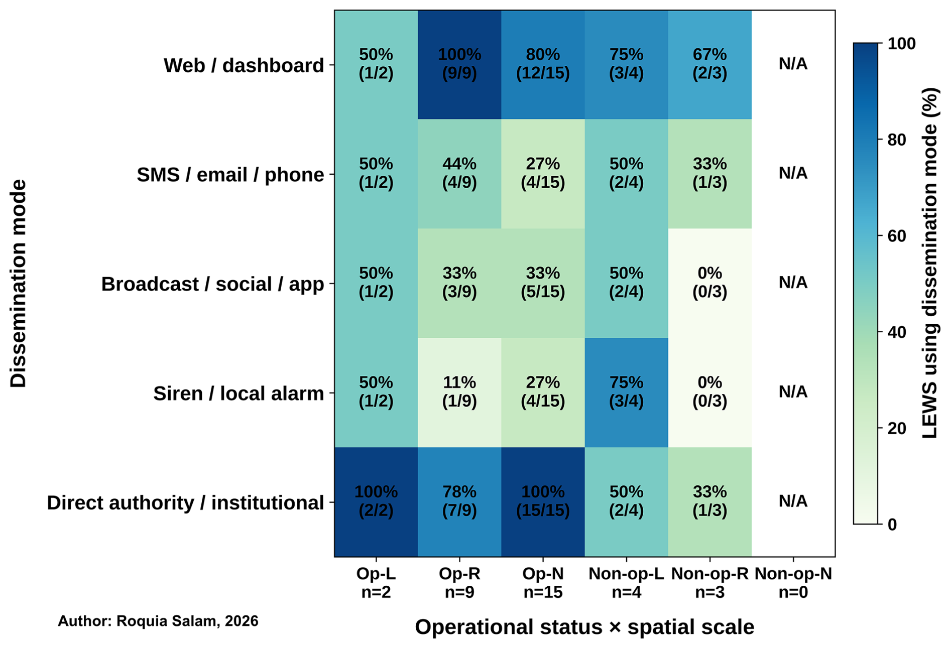
Figure 9Modes of disseminating warnings generated by the forecasting system to the last mile (Op-L: Operational – Local; Op-R: Operational – Regional; Op-N: Operational - National; Non-op-L: Non-operational - Local; Non-op-R: Non-operational - Regional; and Non-op-N: Non-operational – National).
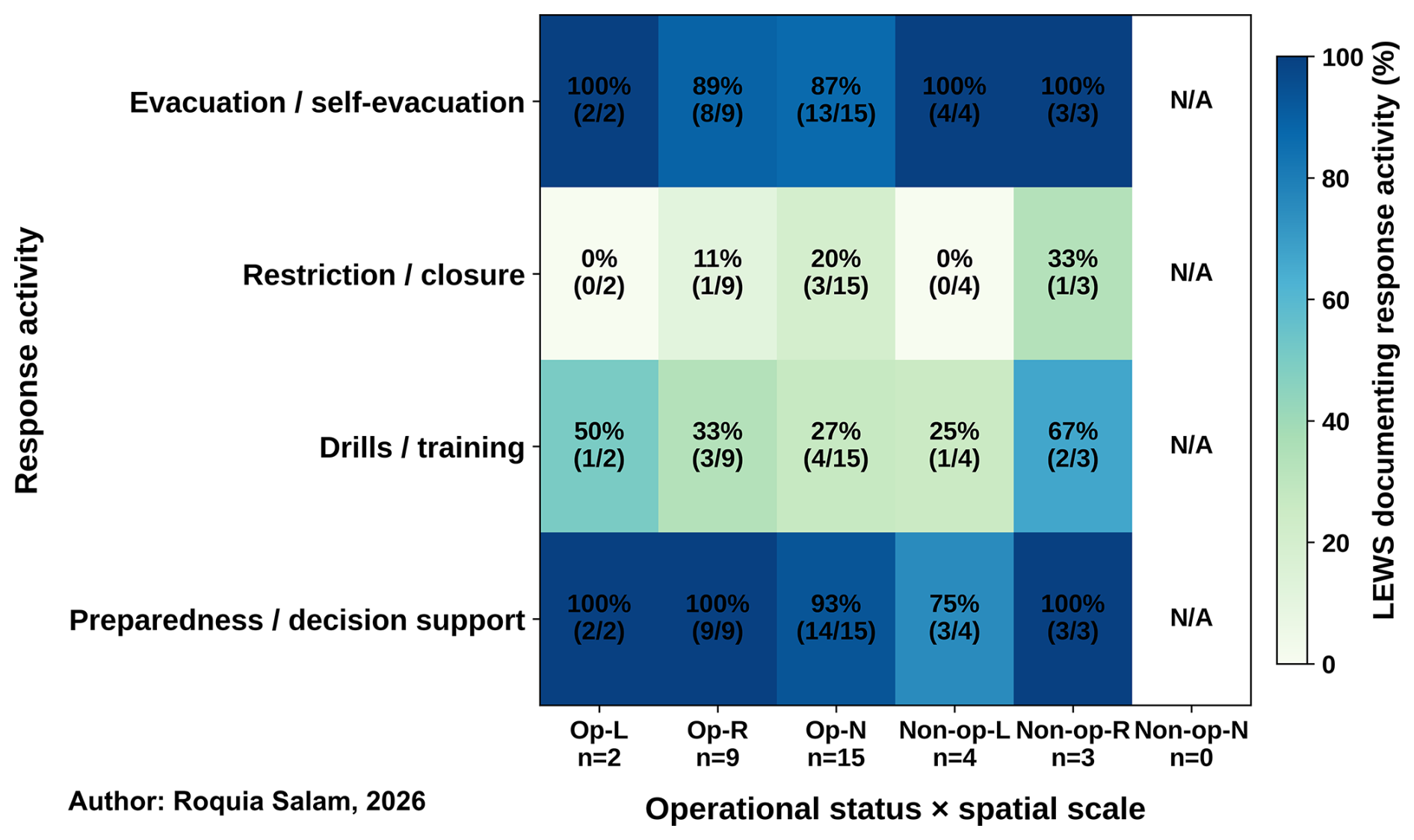
Figure 10Preparedness and response activities across the 33 LEWS (Op-L: Operational – Local; Op-R: Operational – Regional; Op-N: Operational - National; Non-op-L: Non-operational - Local; Non-op-R: Non-operational - Regional; and Non-op-N: Non-operational – National).
The heatmap shows that dissemination through responsible authorities or institutions stood out as the most consistent pathway in operational LEWS (two Local, seven Regional, and 15 National). The second prominent mode of warning dissemination in operational LEWS was web-based platforms/dashboards (one Local, nine Regional, and 12 National). Direct public-facing modes of warning dissemination, such as SMS, email, phone calls, broadcasting, social media, apps, sirens, and local alarms, were reported less consistently. The proposed non-operational LEWS also documented these as intended dissemination modes for future warning dissemination. This pattern suggests that institutional dissemination was the most consistently documented pathway, whereas the use of direct public-facing channels varied among systems. More detailed discussions of warning dissemination and communication can be found in the reviews by Guzzetti et al. (2020) and Piciullo et al. (2018). In these studies, the authors draw not only on their academic research but also on their field experience and information obtained through direct communication with the relevant authorities.
Figure 10 shows the preparedness and response activities documented for 33 LEWS. In both operational (two Local, eight Regional, and 13 National) and non-operational LEWS (four Local and three Regional), evacuation/self-evacuation was identified as one of the most frequently documented response activities. Preparedness/decision support mechanisms were also consistently reported in both operational LEWS (two Local, nine Regional, and 14 National) and non-operational LEWS (three Local and three Regional). Other documented preparedness and response activities included drills, training, restrictions, and closures. The frequencies shown in Figs. 9 and 10 represent practices documented in the searched sources and should not be interpreted as estimates of their prevalence or effectiveness in operational LEWS worldwide.
From the above analyses, it can be stated that operational systems were more consistently represented within the LEWS sample; National systems were found to be more frequently operational, followed by Regional systems; and Local LEWS showed greater variation. However, this pattern may partly reflect the small Local sample size and gaps in reporting. Therefore, it remains difficult to gain a comprehensive understanding of any country's LEWS solely from academic publications. To capture the full picture, deeper engagement with national systems, through direct communication with stakeholders, field visits, or other means, is often necessary. This highlights a significant gap between the literature and operational practice, as the available academic sources provide only partial insights into how LEWS actually operate in practice. Moreover, in academic publications, the terms “early warning system” and “forecasting system” should be used appropriately, as a forecasting system alone should not be considered equivalent to an early warning system.
3.4 Gaps in the LEWS through the lens of the EW4All framework
While considerable contextual variation exists, the reviewed systems suggest that a typical LEWS warning value chain comprises four interrelated pillars: landslide risk knowledge; risk monitoring, detection, forecasting, evaluation, and warning formulation; warning dissemination through appropriate communication channels; and the uptake of warnings to support preparedness and early action. These pillars are functionally interconnected, as each stage provides the basis for the next. Weaknesses in any one pillar can reduce the effectiveness of subsequent stages and ultimately compromise the performance of the system as a whole. The gap analysis of Pillar 1 and Pillar 2 is based on all 45 systems. However, the analysis of gaps in Pillar 3 and Pillar 4 is based on the 33 LEWS. This section highlights the key gaps that concern both operational implementation and the available evidence for assessing such implementation (Fig. 11). It should not be interpreted as a complete inventory of deficiencies in LEWS practice worldwide.
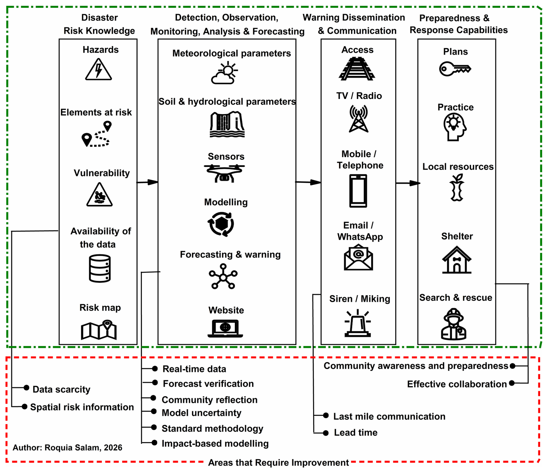
Figure 11Elements of the four Pillars of LEWS based on UN-defined EW4All framework, and areas that require improvement in each pillar.
3.4.1 Pillar 1: Incomplete and insufficiently dynamic risk and impact knowledge
Data scarcity
Data scarcity is one of the most critical challenges. It is often difficult and, in some cases, impossible to obtain essential data such as landslide inventories from many landslide-prone areas (Patton et al., 2023; Liu et al., 2024). Many countries still face serious challenges in landslide observation because of shortages of ground-based and space-based data, particularly in parts of the Global South, Africa, western Latin America, and the Pacific (UN, 2023). This data scarcity is a major constraint on the development of LEWS in these countries. Data limitations are a major concern because landslide forecasting and warning require the integration of information across a range of institutions and specialist disciplines, including meteorology, hydrology, geology, engineering, and communication. In this context, “limited data” is not simply a matter of insufficient observations within a single domain; rather, it reflects a broader, cross-sectoral challenge related to the routine collection, integration, and sharing of critical parameters relevant to LEWS. This issue is therefore closely connected to governance, especially in relation to institutional coordination, data-sharing agreements, and the mechanisms through which information is exchanged among relevant actors. Therefore, it is essential to establish interoperable inventories, documented quality-control procedures, and sustained arrangements among relevant institutions for data sharing. Such data scarcity can directly hamper the implementation of EW4All by weakening risk knowledge, monitoring and forecasting capability, and the evidence base required for timely and reliable early warning.
Spatial risk information
A risk map is a vital element of a LEWS, yet it was largely absent from the reviewed systems. It usually integrates data on all components of risk, such as hazard, vulnerability, and exposure. However, these components do not necessarily contribute equally to the overall level of risk. Exposure is often a major contributor to overall risk. Therefore, it is essential to assign appropriate weights or importance to each component when developing a risk map. Susceptibility maps are sometimes incorrectly interpreted as risk maps, and this distinction should be clearly addressed. A susceptibility map should not be considered equivalent to a risk map. In some LEWS, a susceptibility map is integrated into the system. However, these susceptibility maps are often static rather than dynamically updated (Rossi et al., 2018; Ahmed et al., 2020). This is a limitation because conditions in many landslide-prone areas change continuously. Hill cutting, slope alteration, deforestation, urbanisation, demographic changes, and other factors can alter both susceptibility and exposure over time. Consequently, the associated risk levels may also change, creating a need for regularly updated susceptibility maps. Such updating could be undertaken automatically or semi-automatically at appropriate intervals. The limited availability of up-to-date spatial risk information can hinder the implementation of EW4All by weakening risk knowledge and reducing the capacity to identify and prioritise populations and locations most at risk.
3.4.2 Pillar 2: Monitoring continuity, validation, and scalability
Real-time data
Some landslide-related variables, including rainfall, groundwater conditions, and ground deformation, vary over time and therefore require continuous or near-real-time observation (Krøgli et al., 2018; Sapena et al., 2023). Several barriers (e.g., limited funding and maintenance requirements) can constrain the continuous collection of data (Sapena et al., 2023) from rain gauges, piezometers, and inclinometers. The cross-tabular analysis of the 45 systems indicates that technical monitoring is relatively common; however, it does not always ensure operational use, especially for Local and forecasting-focused systems. A major concern is how to integrate and sustain all required real-time data so that a system remains functional and operationally capable. These include instruments, communications, power supplies, data services, calibration, maintenance, and trained personnel. Beyond financial constraints, institutional factors can also affect implementation and long-term sustainability, including institutional capacity, technical expertise, resource availability, and cooperation among relevant stakeholders (Piciullo et al., 2018; Sapena et al., 2023). From an operational perspective, the choice of monitoring strategy influences system design, maintenance requirements, transferability, and operational scalability (Segoni et al., 2018a; Sapena et al., 2023).
Forecast verification
Forecast verification is an essential component of LEWS, because it provides an objective basis for assessing forecasting skill, identifying false and missed alarms, and refining warning criteria (Piciullo et al., 2017; Guzzetti et al., 2020). Forecast verification may be constrained by the lack of adequate data. The absence of forecast verification may indicate weaknesses in the system development and validation process, thereby reducing confidence in its reliability. Moreover, forecast verification requires substantial funding and human resources, which are often unavailable. Limited availability of these resources can constrain systematic forecast verification and, consequently, undermine confidence in system reliability.
Community reflection
The local community in a landslide-prone area plays a central role in LEWS development and should be given high priority throughout the process (Thapa and Adhikari, 2019; Lempert et al., 2023; Gamperl et al., 2023). LEWS are primarily dedicated to ensuring community safety and reducing potential loss and damage. However, the review found that community engagement was infrequently documented in the reviewed systems, particularly forecasting-focused systems, which may limit their effectiveness in achieving their intended purpose. It is essential to consult local communities regarding the resources available and unavailable in their area, as this can help tailor the system to local needs and conditions (Lempert et al., 2023; Gamperl et al., 2023; Werthmann et al., 2024). Local communities are also an important source of information on how warnings should be communicated and which communication channels are most appropriate and accessible to them. These may include email, SMS, radio or television announcements, megaphone miking, and other locally appropriate channels. Even a technically robust LEWS may be ineffective if warning information is not communicated to local communities in a timely and accessible manner. Local people cannot take appropriate action if warnings do not reach them through suitable communication channels (Lempert et al., 2023; Werthmann et al., 2024). Limited community engagement can hinder the implementation of EW4All by weakening its people-centred approach, particularly by reducing the accessibility, trust, local relevance, and effective use of warnings for timely preparedness and response.
Model uncertainty
Model uncertainty remains a major challenge in LEWS (Segoni et al., 2018a; Patton et al., 2023). To address this issue, generating multiple scenarios based on varying input conditions and conducting a sensitivity analysis can help identify how changes in key parameters affect model outputs. In the case of AI/ML use, these approaches should be supported by local validation, transferability assessment, interpretable outputs, uncertainty communication, and human oversight. Thus, AI should be considered a complementary component of a hybrid LEWS, combined with expert interpretation, field validation, and institutional decision-making (Pfeiffer et al., 2024).
Standard methodology
So far, there is no known universally standard methodology for developing forecasting systems. For instance, there are several monitoring approaches, such as remote sensing, community-based monitoring, and ground-based monitoring. Thus, data are collected using different methods by different users, reflecting inconsistencies in instrumentation and data collection protocols (Piciullo et al., 2017; Liu et al., 2024). This can reduce data quality and, in some cases, make the data difficult to integrate into the system. Another example is the rainfall threshold, which is a key element of rainfall-induced LEWS. However, rainfall thresholds are not used in all LEWS. In some LEWS, dynamic rainfall data are used directly. These methodological differences may contribute to increased false alarm rates. Nevertheless, existing contributions, including the performance and evaluation frameworks discussed by Calvello (2017) and Guzzetti et al. (2020), provide a useful foundation for threshold validation, warning-level evaluation, and operational performance assessment. However, it is unclear from the EW4All framework how a standard methodology could be applied globally when landslide characteristics vary considerably between locations.
Impact-based modelling
A key gap in existing LEWS is the limited use of impact-based modelling (Guzzetti et al., 2020). Impact-based modelling should link the likelihood of forecast landslide occurrence with the exposure and vulnerability of people, infrastructure, and public services. If impact-based warnings are available, local communities can make more informed preparedness decisions and take appropriate actions to reduce their risks. The limited use of impact-based modelling can constrain the implementation of EW4All by weakening the connection between forecast hazards and their likely consequences for exposed and vulnerable populations, thereby limiting informed and timely preparedness and response actions.
3.4.3 Pillar 3: Last mile communication, and lead time
Last mile communication
Academic publications often describe thresholds, monitoring, and forecasting methods in greater technical detail than they describe who is authorised to issue a warning, how alerts move through institutional and community channels, or how preparedness and response are activated. Figure 9 shows that dissemination through responsible authorities or institutions and web-based platforms/dashboards were the most consistently documented modes of warning dissemination. Direct public-facing modes of warning dissemination, such as SMS, email, phone calls, broadcasting, social media, apps, sirens, and local alarms, were reported less consistently. However, the availability of warning channels alone is insufficient (Thapa and Adhikari, 2019; Werthmann et al., 2024). The warning should reach the appropriate community in the relevant location and specify the potential hazard, timing, impacts, uncertainty, and recommended actions in locally understandable formats (UNDRR and WMO, 2025). Communication planning should consider the multiple languages used within local communities, differences in literacy, disability, trust, connectivity, and the possibility that one or more dissemination channels may fail (UNDRR and WMO, 2025; Werthmann et al., 2024). For instance, in remote and mountainous areas, mobile and internet connectivity, as well as road access, may be severely disrupted during the monsoon season. Similarly, warnings delivered through megaphones or sirens may not reach all vulnerable locations. Under the EW4All warning dissemination and communication pillar, effective LEWS require redundant and locally appropriate communication pathways so that warnings can reach exposed populations despite differences in connectivity, literacy, language, disability, and access to communication technologies. The comparatively limited reporting of SMS, email, phone calls, broadcasting, social media, apps, sirens, and local alarms therefore highlights a documentation and implementation gap in last-mile communication that demands greater attention. Therefore, locally appropriate, manageable, and adaptable communication techniques should be adopted. These requirements strengthen the people-centred function of Pillar 3 without assuming that limited reporting is equivalent to the absence of operational practice.
Lead time
The time interval between warning dissemination to the community and the anticipated occurrence of a hazardous event is operationally important because it determines whether appropriate protective actions can be completed (Tupper and Fearnley, 2023; Werthmann et al., 2024). A technically adequate forecast can still provide limited benefit if responsibilities are unclear or if evacuation destinations, transport arrangements, support for people requiring assistance, and decision protocols cannot be activated within the available lead time (Tupper and Fearnley, 2023; Werthmann et al., 2024; UNDRR and WMO, 2025).
3.4.4 Pillar 4: Preparedness and response
Community awareness and preparedness
Figure 10 shows the preparedness and response activities documented for 33 LEWS. Evacuation or self-evacuation and preparedness or decision-support mechanisms were the most frequently documented activities, while drills, training, restrictions, and closures were reported less consistently across operational-status and spatial-scale groups. However, these frequencies do not provide sufficient information to assess how effective these activities were for local communities. Evacuation or self-evacuation and preparedness or decision-support mechanisms may not always lead to effective community responses. Local people may not take proactive measures even after receiving an EW because of limited awareness or preparedness (Piciullo et al., 2018). In some cases, they may also be uncertain about the actions required to protect themselves from danger. Others may understand the warning and the recommended actions but still choose not to respond, for example because of risk perception, previous experience, trust, or other social and cultural factors.
Under the EW4All preparedness-to-respond pillar, drills and training are essential for translating landslide warnings into timely and appropriate protective actions by testing response procedures, clarifying institutional and community responsibilities, and improving public understanding of how to respond when an alert is issued. Similarly, restrictions and closures can reduce exposure by limiting access to hazardous areas during periods of elevated landslide risk; therefore, their comparatively limited reporting across the reviewed LEWS indicates that these practical warning-to-action mechanisms require greater attention to strengthen the overall effectiveness of LEWS. Therefore, greater emphasis should be placed on strengthening community awareness and preparedness through locally appropriate activities, such as mock drills, workshops, street theatre, booklets, posters, and other forms of communication delivered in local languages.
Effective collaboration
In many cases, local resources, such as emergency managers, volunteers, and community actors, are available but are not effectively mobilised when needed. This can delay preparedness and response actions and increase the severity of disaster impacts. Such shortcomings often reflect weak coordination and collaboration among relevant actors. Effective coordination and collaboration with locally available resources can help reduce loss and damage, yet these arrangements may remain underutilised even where advanced warning systems are in place. Preparedness depends on prior participation, credible and understandable warnings, feasible protective options, inclusive planning, regular exercises, and feedback after warning events (Tupper and Fearnley, 2023; Werthmann et al., 2024).
Overall, the analysis of 45 systems does not indicate that the principal weakness of rainfall-induced LEWS lies in one technology or one pillar. Rather, it indicates an uneven transition from risk and forecasting information to authorised communication and feasible early action. Several gaps remain and require collaborative improvement, particularly in relation to Pillars 3 and 4. Researchers are making substantial contributions to Pillars 1 and 2. Forecast issuance (Pillar 2) provides the basis for warning dissemination and communication (Pillar 3). One of the most important components of LEWS is the preparedness and response capacity of the community (Pillar 4). A LEWS is more likely to be effective when Pillars 3 and 4 function adequately and are well integrated with the preceding pillars. A LEWS may still be ineffective despite a sophisticated Pillar 2 and an effective Pillar 3 if adequate preparedness and response mechanisms are lacking, as information generated through the preceding pillars does not automatically translate into protective action. Many activities are implemented in isolation and are fragmented across different locations and organisations, making it difficult to unlock the full potential and overall effectiveness of LEWS. As LEWS comprises multiple interconnected pillars, each of which needs to function effectively, collaboration across multiple partners, institutions, and sectors is essential. Such collaboration remains limited in several areas and therefore needs to be strengthened. Therefore, institutional capacity should be strengthened, alongside partnerships and coordination among stakeholders working across different pillars, to ensure the effective integration and functioning of LEWS.
The EW4All framework is very comprehensive. It clearly calls for action across several areas, with a strong emphasis on protecting people and improving human well-being. However, it also presents several feasibility concerns beyond the broader challenges and gaps discussed in the previous section. Some of the feasibility concerns are outlined briefly here.
4.1 Financing and sustained implementation capacity
It calls for the implementation of MHEWS worldwide. Funding is a major challenge in this regard, especially for SIDS and LDCs. At present, the UN is providing direct financial support to only 30 selected countries in the initial phase of this framework, which appears insufficient relative to the global scale of implementation required. The latest UN global assessment report found that LDCs and SIDS still face inadequate funding for implementing the EW4All framework at the national level (UNDRR and WMO, 2025). Therefore, how all countries will secure the sustained funding necessary to implement and maintain EW4All remains a significant concern. This creates a significant feasibility concern, since securing adequate and sustained funding is challenging and represents an essential prerequisite for initiating and maintaining such a programme. This concern is particularly important given the scale and ambition required to achieve universal coverage within a relatively short implementation period (Tupper and Fearnley, 2023).
4.2 Global consistency and local adaptation
The framework appears to promote common standards, or methods, or approaches across different contexts. This is challenging, as lithology, physiography, geology, climatology, land use, rainfall patterns, and other characteristics differ considerably across the globe. Given these variations, it may not be feasible to apply a single approach to LEWS development in all locations. Recent research similarly emphasises that standardisation in MHEWS must retain sufficient flexibility to account for variations in scale, hazards, populations, and local needs (Rokhideh et al., 2025).
4.3 Global forecasting products and local calibration
A related concern is how to balance globally standardised forecasting tools with the local calibration required for operational LEWS. In practice, reliable landslide forecasting systems require locally or regionally appropriate thresholds and proper calibration (Piciullo et al., 2017; Nocentini et al., 2024), which may not align with a uniform global model. Relying on a uniform model risks producing overly general outputs that are less useful at the local level. This limitation is recognised in the latest global assessment report, which notes that detailed local prediction cannot be achieved using global meteorological products alone (UNDRR and WMO, 2025).
4.4 Last mile communication
Last mile communication presents another significant challenge, particularly in areas with high linguistic diversity. Populations at risk may include people in remote locations, those without reliable telecommunications, people with disabilities, transient populations, and speakers of different languages, meaning that no single communication channel is likely to reach all groups effectively (UNDRR and WMO, 2025).
4.5 Inclusivity in operational implementation
While the framework highlights inclusivity, which is indeed vital, it does not provide clear guidelines on how to achieve it in practice. Experience shows that even in regions or countries with a large number of landslide forecasting systems, warning dissemination and response often fail due to extreme weather, difficult geography, or other barriers. Since “safety first” is a fundamental principle for emergency workers, they cannot be expected to place themselves at unacceptable risk in the immediate aftermath of a disaster. Responders may need to wait until conditions become sufficiently safe before they can assist affected people. As these situations are often shaped by hazard conditions and local physical constraints, ensuring complete inclusivity in practice remains difficult. The 2025 global assessment acknowledges that the implementation of inclusive approaches often lags behind policy commitments and that MHEWS may fail to reach or adequately meet the needs of diverse and marginalised groups (UNDRR and WMO, 2025).
4.6 Feasibility of universal coverage by 2027
The framework aims to achieve universal MHEWS coverage by the end of 2027. It is unclear how this target will be met, given that 2026 is already well advanced and many of the designated countries still face serious resource and capacity constraints. While the UN is providing some support, the countries outside the current support pool face even greater uncertainty. For them, implementing this framework within the stated timeframe may be particularly challenging. The same assessment concluded that, despite tangible progress at the halfway stage of EW4All, considerable work was still required to achieve universal coverage, particularly because many LDCs and SIDS lacked sufficient financial resources for implementation (UNDRR and WMO, 2025).
Other feasibility issues may also constrain the effective implementation of EW4All (Rokhideh et al., 2025). Therefore, a more detailed and region-specific framework under the broader EW4All framework may be needed, one that accounts for contextual realities rather than relying solely on a broad global model.
The analysis of 45 systems indicates that significant progress has been made towards the operationalisation of LEWS. Operational LEWS can support community preparedness, response, and risk mitigation capabilities, thereby contributing to an overall reduction in disaster risk. However, progress remains fragmented and uneven.
The analysis of 45 systems shows that 27 were classified as operational, indicating substantial operational implementation within the reviewed systems, although this implementation remains uneven across spatial scales and system types. Local systems showed particularly limited operational maturity. National-scale LEWS were largely operational, while forecasting-focused systems were rarely operational, and systems incorporating susceptibility mapping showed a higher proportion of operational status. The findings reflected not only technical challenges but also wider implementation barriers, including limited funding, maintenance requirements, weak institutional coordination, unclear warning mandates, and insufficient communication and response protocols.
The restriction to English-language publications may have excluded relevant systems studies and operational evidence published in other languages, potentially affecting the representativeness of the reviewed sample and limiting the global scope of the findings.
One of the main findings is that the current academic literature is concentrated on Pillars 1 and 2, whereas Pillars 3 and 4 remain underreported in academic publications. This indicates a structural imbalance between technical LEWS development and the people-centred operational requirements of EW4All. It also highlights a gap between academic publications and operational reality. Many studies describe forecasting methods in detail; however, they provide limited information on institutional responsibility, warning dissemination, community preparedness, and response planning. This affects the robustness of global comparisons, as differences between systems may partly reflect differences in reporting practices rather than differences in actual operational performance. While EW4All provides an important global framework, its feasibility for LEWS is constrained by insufficient funding, the promotion of standardised models that may not adequately account for local thresholds, and persistent challenges related to inclusivity and last-mile communication. Future LEWS development should prioritise operational governance, risk- and impact-based information, last-mile communication, preparedness, and scalable approaches that remain responsive to local landslide conditions. Unless region-specific approaches are prioritised and adequate resources are secured, establishing effective LEWS globally by 2027 will remain difficult. A LEWS is more likely to be effective when Pillars 3 and 4 function adequately and are well integrated with the preceding pillars.
Table A1Rainfall-induced LEWS records reviewed (2015–2026), including locality, areal coverage, system scale, system type (LEWS vs. forecasting-focused), operational evidence, evidence strength, the evidence basis for each EW4All pillar, source type, and reference.

Note: The URLs were active at the time the article was processed.
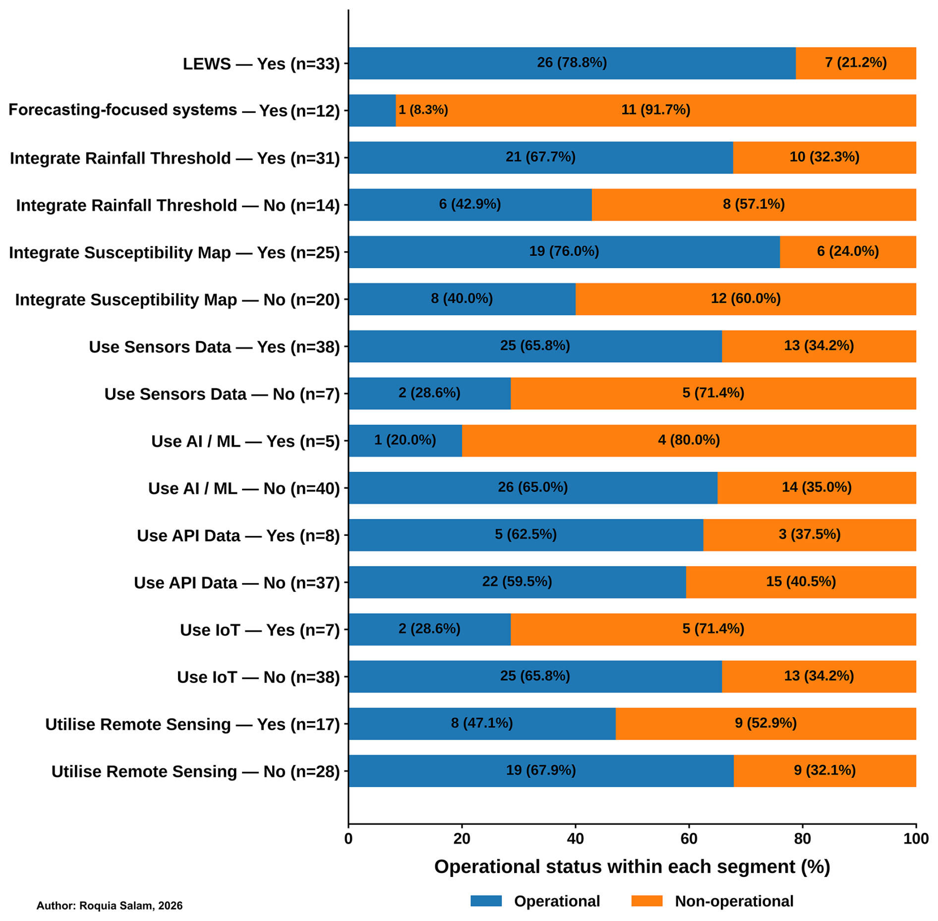
Table A2Distribution of operational status and spatial scale across some key system characteristics, stratified by system type.
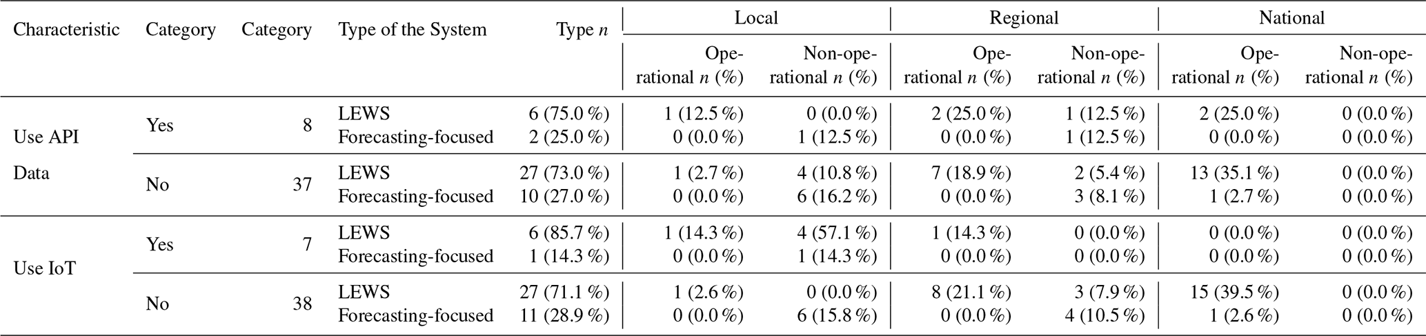
Note: Percentages in “Type n” are calculated using the corresponding characteristic-category total as the denominator. Percentages in the Local, Regional, and National columns use the same characteristic-category denominator. All values refer to the reviewed sample.
The data used to create the historical disaster trends (Figs. 3 and 4) were obtained from EM-DAT, the International Disaster Database, and can be downloaded directly from https://www.emdat.be/ (last access: 21 October 2026).
Roquia Salam, Bayes Ahmed, and Peter Sammonds conceptualised the research. Roquia Salam and Bayes Ahmed designed the methodology. Roquia Salam collected the resources, carried out the analysis, and wrote the associated interpretation. Bayes Ahmed and Peter Sammonds supervised and reviewed the manuscript. Roquia Salam prepared the final manuscript with contributions from all co-authors.
At least one of the (co-)authors is a member of the editorial board of Natural Hazards and Earth System Sciences. The peer-review process was guided by an independent editor, and the authors also have no other competing interests to declare.
Publisher's note: Copernicus Publications remains neutral with regard to jurisdictional claims made in the text, published maps, institutional affiliations, or any other geographical representation in this paper. The authors bear the ultimate responsibility for providing appropriate place names. Views expressed in the text are those of the authors and do not necessarily reflect the views of the publisher.
This article is part of the special issue “Early Warning Systems from Research to Operations: Status, Innovations and Multi-Hazard Applications”. It is not associated with a conference.
This work is part of the PhD thesis of Roquia Salam, who is grateful to University College London (UCL) for supporting her PhD study.
Declaration of AI-assisted technology: The main text of this work was originally written by the lead author. ChatGPT was used to improve sentence structure and readability, including punctuation, spelling, and grammatical checks, while ensuring that the original ideas and meaning remained unchanged. After using this tool, the authors carefully reviewed and edited the content as needed.
This research has been supported by University College London (UCL Research Excellence Scholarship awarded to Roquia Salam for her PhD study).
This paper was edited by Timothy Tiggeloven and reviewed by Pasquale Marino and one anonymous referee.
Ahmed, B., Rahman, M. S., Islam, R., Sammonds, P., Zhou, C., Uddin, K., and Al-Hussaini, T. M.: Developing a dynamic Web-GIS based landslide early warning system for the Chittagong Metropolitan Area, Bangladesh, ISPRS Int. J. Geo-Inf., 7, 485, https://doi.org/10.3390/ijgi7120485, 2018.
Ahmed, B., Rahman, M. S., Sammonds, P., Islam, R., and Uddin, K.: Application of geospatial technologies in developing a dynamic landslide early warning system in a humanitarian context: the Rohingya refugee crisis in Cox's Bazar, Bangladesh, Geomatics, Natural Hazards and Risk, 11, 446–468, https://doi.org/10.1080/19475705.2020.1730988, 2020.
Ahmed, B., Mahamud, R., Alam, S. M. R. A., Arif, M. T. A., and Bhuiyan, M. S. H.: Designing Standard Operating Procedures for a Landslide Early Warning System for Cox's Bazar, Bangladesh, in: Progress in Landslide Research and Technology, Volume 4 Issue 2, 2025, 345–364, Springer, https://doi.org/10.1007/978-3-032-18863-2_23, 2026.
Alcántara-Ayala, I.: Landslides in a changing world, Landslides, 22, 2851–2865, https://doi.org/10.1007/s10346-024-02451-1, 2025.
ARPA Piemonte: Scenario di innesco frane, Agenzia Regionale per la Protezione Ambientale del Piemonte (ARPA Piemonte), https://www.arpa.piemonte.it/rischi_naturali/snippets_arpa/frane/ (last access: 21 October 2026), 2026.
Azarafza, M., Azarafza, M., Akgün, H., Atkinson, P. M., and Derakhshani, R.: Deep learning-based landslide susceptibility mapping, Sci. Rep., 11, 24112, https://doi.org/10.1038/s41598-021-03585-1, 2021.
Barthélemy, S., Bernardie, S., and Grandjean, G.: Assessing rainfall threshold for shallow landslides triggering: a case study in the Alpes Maritimes region, France, Nat. Hazard., 121, 4023–4049, https://doi.org/10.1007/s11069-024-06941-2, 2024.
Calvello, M.: Early warning strategies to cope with landslide risk, Riv. Ital. Geotec., 2, 63–91, https://doi.org/10.19199/2017.2.0557-1405.063, 2017.
Calvello, M., D'Orsi, R. N., Piciullo, L., Paes, N., Magalhaes, M., and Lacerda, W. A.: The Rio de Janeiro early warning system for rainfall-induced landslides: Analysis of performance for the years 2010–2013, Int. J. Disast. Risk Re., 12, 3–15, https://doi.org/10.1016/j.ijdrr.2014.10.005, 2015a.
Calvello, M., D'Orsi, R. N., Piciullo, L., Paes, N. M., Magalhaes, M. A., Coelho, R., and Lacerda, W. A.: The community-based alert and alarm system for rainfall induced landslides in Rio de Janeiro, Brazil, in: Engineering Geology for Society and Territory – Volume 2: Landslide Processes, 653–657, Springer International Publishing, https://doi.org/10.1007/978-3-319-09057-3_109, 2015b.
Chaturvedi, P., Srivastava, S., and Kaur, P. B.: Landslide Early Warning System Development Using Statistical Analysis of Sensors' Data at Tangni Landslide, Uttarakhand, India, in: Proceedings of Sixth International Conference on Soft Computing for Problem Solving, 259–270, Springer, https://doi.org/10.1007/978-981-10-3325-4_26, 2017.
CRED: EM-DAT – The International Disaster Database, Centre for Research on the Epidemiology of Disasters (CRED), UCLouvain, Brussels, Belgium, https://www.emdat.be/ (last access: 21 October 2026), 2026.
de Andrade, M. R. M., Bortolozo, C. A., Carvalho, A. R., Egas, H. M., Garcia, K., Metodiev, D., Nery, T. D., Prieto, C., Pryer, T., Saito, S. M., and Scofield, G.: The SNAKE System: CEMADEN's Landslide Early Warning System (LEWS) Mechanism, Int. J. Geosci., 14, 1146–1159, https://doi.org/10.4236/ijg.2023.1411058, 2023.
DMR.: Daily Landslide-Susceptibility Areas from AP Model, Department of Mineral Resources (DMR), Thailand, https://data.dmr.go.th/dataset/daily-susceptibility-data-from-ap-model (last access: 21 October 2026), 2026.
Farina, P., Catani, F., Rosi, A., Setiawan, I., Junaidi, A., Afrizal, K., and Wijayanto, A.: Development of an early warning system for shallow landslide hazard in the Grasberg area, Indonesia, in: Slope Stability 2020: Proceedings of the 2020 International Symposium on Slope Stability in Open Pit Mining and Civil Engineering, 1425–1438, Australian Centre for Geomechanics, Perth, https://doi.org/10.36487/ACG_repo/2025_98, 2020.
Froude, M. J. and Petley, D. N.: Global fatal landslide occurrence from 2004 to 2016, Nat. Hazards Earth Syst. Sci., 18, 2161–2181, https://doi.org/10.5194/nhess-18-2161-2018, 2018.
Fustos-Toribio, I., Manque-Roa, N., Vásquez Antipan, D., Hermosilla Sotomayor, M., and Letelier Gonzalez, V.: Rainfall-induced landslide early warning system based on corrected mesoscale numerical models: an application for the southern Andes, Nat. Hazards Earth Syst. Sci., 22, 2169–2183, https://doi.org/10.5194/nhess-22-2169-2022, 2022.
Gamperl, M., Singer, J., and Thuro, K.: Internet of things geosensor network for cost-effective landslide early warning systems, Sensors, 21, 2609, https://doi.org/10.3390/s21082609, 2021.
Gamperl, M., Singer, J., Garcia-Londoño, C., Seiler, L., Castañeda, J., Cerón-Hernandez, D., and Thuro, K.: Recommendations for Landslide Early Warning Systems in Informal Settlements Based on a Case Study in Medellín, Colombia, Land, 12, 1451, https://doi.org/10.3390/land12071451, 2023.
Gian, Q. A., Tran, D.-T., Nguyen, D. C., Nhu, V. H., and Tien Bui, D.: Design and implementation of site-specific rainfall-induced landslide early warning and monitoring system: a case study at Nam Dan landslide (Vietnam), Geomatics, Nat. Hazard. Risk, 8, 1978–1996, https://doi.org/10.1080/19475705.2017.1401561, 2017.
GSI: Landslide Hazard, Bhusanket, Geological Survey of India (GSI), https://bhusanket.gsi.gov.in/LanslideHazard.html (last access: 21 October 2026), 2026.
Guo, Z., Yin, K., Gui, L., Liu, Q., Huang, F., and Wang, T.: Regional rainfall warning system for landslides with creep deformation in three gorges using a statistical black box model, Sci. Rep., 9, 8962, https://doi.org/10.1038/s41598-019-45403-9, 2019.
Guterres, A.: United Nations Secretary-General's message on World Meteorological Day, United Nations, https://www.un.org/sg/en/content/sg/statements/2022-03-23/secretary-generals-message-world-meteorological-day (last access: 21 October 2026), 2022.
Guzzetti, F.: Invited perspectives: Landslide populations – can they be predicted?, Nat. Hazards Earth Syst. Sci., 21, 1467–1471, https://doi.org/10.5194/nhess-21-1467-2021, 2021.
Guzzetti, F., Gariano, S. L., Peruccacci, S., Brunetti, M. T., Marchesini, I., Rossi, M., and Melillo, M.: Geographical landslide early warning systems, Earth-Sci. Rev., 200, 102973, https://doi.org/10.1016/j.earscirev.2019.102973, 2020.
Haque, U., Da Silva, P. F., Devoli, G., Pilz, J., Zhao, B., Khaloua, A., Wilopo, W., Andersen, P., Lu, P., Lee, J., Yamamoto, T., Keellings, D., Wu, J.-H., and Glass, G. E.: The human cost of global warming: Deadly landslides and their triggers (1995–2014), Sci. Total Environ., 682, 673–684, https://doi.org/10.1016/j.scitotenv.2019.03.415, 2019.
Harilal, G. T., Madhu, D., Ramesh, M. V., and Pullarkatt, D.: Towards establishing rainfall thresholds for a real-time landslide early warning system in Sikkim, India, Landslides, 16, 2395–2408, https://doi.org/10.1007/s10346-019-01244-1, 2019.
Hidayat, R., Sutanto, S. J., Hidayah, A., Ridwan, B., and Mulyana, A.: Development of a landslide early warning system in Indonesia, Geosciences, 9, 451, https://doi.org/10.3390/geosciences9100451, 2019.
IDEAM: Boletín de Alertas por Pronóstico de la Amenaza por Deslizamientos de Tierra (BADT), Instituto de Hidrología, Meteorología y Estudios Ambientales (IDEAM), IDEAM BADT bulletin archive, https://www.ideam.gov.co/sala-de-prensa/boletines/Boletín-de-Alertas-por-Pronóstico-de-la-Amenaza (last access: 21 October 2026), 2026.
INDECI: 634 distritos de la sierra centro y sur en riesgo por precipitaciones, Instituto Nacional de Defensa Civil (INDECI), Nota de Prensa No. 096-2026, Official INDECI notice, https://www.gob.pe/institucion/indeci/noticias/1369452-634-distritos-de-la-sierra-centro-y-sur-en-riesgo (last access: 21 October 2026), 2026.
INGEMMET: Ingemmet identifica 185 zonas críticas por peligros geológicos ante lluvias, Instituto Geológico, Minero y Metalúrgico (INGEMMET), https://www.gob.pe/institucion/ingemmet/noticias/1355346-ingemmet-identifica-185-zonas-criticas-por-peligros (last access: 21 October 2026), 2026.
IPCC: Climate Change 2023: Synthesis Report. Contribution of Working Groups I, II and III to the Sixth Assessment Report of the Intergovernmental Panel on Climate Change (IPCC), edited by: Core Writing Team, Lee, H., and Romero, J., IPCC, Geneva, Switzerland, 184 pp., https://doi.org/10.59327/IPCC/AR6-9789291691647, 2023.
JMA: Information at a glance: Real-time Landslide Risk Map and Weather Warnings/Advisories, Japan Meteorological Agency (JMA), https://www.jma.go.jp/jma/en/quickinfo/quickinfo.html (last access: 21 October 2026), 2026.
JMG: Sistem Amaran Bencana Geologi, Jabatan Mineral dan Geosains Malaysia (JMG), https://ews.jmg.gov.my/ (last access: 21 October 2026), 2026.
Ju, N., Huang, J., He, C., Van Asch, T. W. J., Huang, R., Fan, X., Xu, Q., Xiao, Y., and Wang, J.: Landslide early warning, case studies from Southwest China, Eng. Geol., 279, 105917, https://doi.org/10.1016/j.enggeo.2020.105917, 2020.
Ju, N. P., Huang, J., Huang, R. Q., He, C. Y., and Li, Y. R.: A Real-time Monitoring and Early Warning System for Landslides in Southwest China, J. Mount. Sci., 12, 1219–1228, https://doi.org/10.1007/s11629-014-3307-7, 2015.
Kebaili, M. O., Foughali, K., Fathallah, K., Frihida, A., Ezzeddine, T., and Claramunt, C.: Landsliding Early Warning Prototype Using MongoDB and Web of Things Technologies, Procedia Comput. Sci., 98, 578–583, https://doi.org/10.1016/j.procs.2016.09.090, 2016.
KFS: Landslide Information System – Landslide Prediction Information, Korea Forest Service (KFS), Korea Forest Service Landslide Information System, https://sansatai.forest.go.kr/mhms_pub/mhms/main/mainPage.do (last access: 21 October 2026), 2026.
Khan, M. Y., Shafique, M., Turab, S. A., and Ahmad, N.: Characterization of an unstable slope using geophysical, UAV, and geological techniques: Karakoram Himalaya, Northern Pakistan, Front. Earth Sci., 9, 668011, https://doi.org/10.3389/feart.2021.668011, 2021.
Konagai, K., Karunawardena, A., Bandara, K. N., Sassa, K., Onishi, R., Uzuoka, R., Asano, S., Sasahara, K., Jayakody, S., and Ariyarathna, I.: Early warning system against rainfall-induced landslide in Sri Lanka, in: Progress in Landslide Research and Technology, Volume 1 Issue 1, 2022, 217–235, Cham: Springer International Publishing, https://doi.org/10.1007/978-3-031-16898-7_16, 2023.
Kong, V. W. W., Kwan, J. S. H., and Pun, W. K.: Hong Kong's landslip warning system – 40 years of progress, Landslides, 17, 1453–1463, https://doi.org/10.1007/s10346-020-01379-6, 2020.
Krøgli, I. K., Devoli, G., Colleuille, H., Boje, S., Sund, M., and Engen, I. K.: The Norwegian forecasting and warning service for rainfall- and snowmelt-induced landslides, Nat. Hazards Earth Syst. Sci., 18, 1427–1450, https://doi.org/10.5194/nhess-18-1427-2018, 2018.
Kumar, M. N. and Ramesh, M. V.: Accurate IoT based slope instability sensing system for landslide detection, IEEE Sens. J., 22, 17151–17161, https://doi.org/10.1109/JSEN.2022.3189903, 2022.
Lay, T.: Why giant earthquakes keep catching us out, Nature, 483, 149–150, https://doi.org/10.1038/483149a, 2012.
Lee, R., White, C. J., Adnan, M. S. G., Douglas, J., Mahecha, M. D., O'Loughlin, F. E., Patelli, E., Ramos, A. M., Roberts, M. J., Martius, O., Tubaldi, E., van den Hurk, B., Ward, P. J., and Zscheischler, J.: Reclassifying historical disasters: From single to multi-hazards, Sci. Total Environ., 912, 169120, https://doi.org/10.1016/j.scitotenv.2023.169120, 2024.
Lempert, R. J., Busch, L., Brown, R., Patton, A., Turner, S., Schmidt, J., and Young, T.: Community-Level, Participatory Co-Design for Landslide Warning with Implications for Climate Services, Sustainability, 15, 4294, https://doi.org/10.3390/su15054294, 2023.
Lin, W., Palau, R. M., Hürlimann, M., Yin, K., and Li, Y.: A Regional-Scale Early Warning System for Rainfall-Induced Shallow Landslides Based on the Outputs of a Physically Based Model: Application to Cili County, China, Water, 18, 168, https://doi.org/10.3390/w18020168, 2026.
Liu, L., Deng, J., and Tang, Y.: A dynamic management and integration framework for models in landslide early warning system, ISPRS Int. J. Geo-Info., 12, 198, https://doi.org/10.3390/ijgi12050198, 2023a.
Liu, S., Du, J., Yin, K., Zhou, C., Huang, C., Jiang, J., and Yu, J.: Regional early warning model for rainfall induced landslide based on slope unit in Chongqing, China, Eng. Geol., 333, 107464, https://doi.org/10.1016/j.enggeo.2024.107464, 2024.
Liu, Y., Hazarika, H., Kanaya, H., Takiguchi, O., Murai, M., Hidayat, M. N., and Kochi, Y.: Design and Deployment of an IoT-based Landslide Early Warning System, in: 2022 International Conference and Utility Exhibition on Energy, Environ. Clim. Change (ICUE), 1–7, IEEE, https://doi.org/10.1109/ICUE55325.2022.10113491, 2022.
Liu, Y., Hazarika, H., Murai, M., and Kochi, Y.: An IoT-based sustainable early warning system for rainfall induced landslides, in: Smart Geotechnics for Smart Societies, 1141–1144, CRC Press, https://doi.org/10.1201/9781003299127-161, 2023b.
MGB-V.: Mines and Geosciences Bureau Regional Office V., Mines and Geosciences Bureau Regional Office V (MGB-V), Department of Environment and Natural Resources, https://region5.mgb.gov.ph/ (last access: 21 October 2026), 2026.
Miraballes, M. N. L.: Establishing Landslide Early Warning System Using Rainfall Thresholds in the Province of Albay, Philippines, Mines and Geosciences Bureau Region V (MGB-V), Official MGB technical document, https://mgb.gov.ph/images/Research__Development/12_-_T06_ESTABLISHING_LANDSLIDE_EARLY_WARNING_SYSTEM_USING_RAINFALL.pdf (last access: 21 October 2026), 2021.
Mondal, A. U., Liu, X., and Li, B.: Development and Deployment of IoT-Based Early Warning System for Rainfall-Induced Landslides Using Surface and Subsurface Sensors and Its Application, Appl. Sci., 16, 5738, https://doi.org/10.3390/app16125738, 2026.
Murgia, E., Galli, A., Rinaldi, A., Agostino, I., Peca, M., Morgia, M., and Innocca, F.: SANF-RFI: An operational early warning system for rainfall-induced landslides along the Italian railway network, Proceedings of the Institution of Mechanical Engineers, Part F: Journal of Rail and Rapid Transit, OnlineFirst, https://doi.org/10.1177/09544097261456885, 2026.
Naidu, S., Sajinkumar, K. S., Oommen, T., Anuja, V. J., Samuel, R. A., and Muraleedharan, C.: Early warning system for shallow landslides using rainfall threshold and slope stability analysis, Geosci. Front., 9, 1871–1882, https://doi.org/10.1016/j.gsf.2017.10.008, 2018.
NDMA: Disasters Early Warning 2 (DEW 2), National Disaster Management Authority (NDMA), Pakistan, NDMA Disaster Early Warning 2, https://ndma.gov.pk/ (last access: 21 October 2026), 2026.
Niyibizi, J. P. and Valentino, R.: A Comprehensive Landslide Early Warning System for Rwanda: Integrating Predictive Modeling, Environmental Parameters, and Community Engagement, Int. J. Appl. Adv. Sci. Res., 10, 48–60, 2025.
Nocentini, N., Medici, C., Barbadori, F., Gatto, A., Franceschini, R., Del Soldato, M., Rosi, A., and Segoni, S.: Optimization of rainfall thresholds for landslide early warning through false alarm reduction and a multi-source validation, Landslides, 21, 557–571, https://doi.org/10.1007/s10346-023-02176-7, 2024.
NWS: Post-fire burn scar – Debris flow and flash flooding, National Weather Service (NWS), Seattle, WA, National Oceanic and Atmospheric Administration, https://www.weather.gov/sew/burnscar (last access: 21 October 2026), 2026.
Ofoeda, J., Boateng, R., and Effah, J.: Application programming interface (API) research: A review of the past to inform the future, Int. J. Enterp. Info. Syst. (IJEIS), 15, 76–95, https://doi.org/10.4018/IJEIS.2019070105, 2019.
Ozturk, U., Bozzolan, E., Holcombe, E. A., Shukla, R., Pianosi, F., and Wagener, T.: How climate change and unplanned urban sprawl bring more landslides, Nature, 608, 262–265, https://doi.org/10.1038/d41586-022-02141-9, 2022.
Park, J. Y., Lee, S.-R., Lee, D.-H., and Choi, G. M.: A study of the combination of risk analysis with a citywide landslide early warning system, WIT T. Eng. Sci., 121, 21–31, https://doi.org/10.2495/RISK180021, 2018.
Patton, A. I., Luna, L. V., Roering, J. J., Jacobs, A., Korup, O., and Mirus, B. B.: Landslide initiation thresholds in data-sparse regions: application to landslide early warning criteria in Sitka, Alaska, USA, Nat. Hazards Earth Syst. Sci., 23, 3261–3284, https://doi.org/10.5194/nhess-23-3261-2023, 2023.
Pecoraro, G., Calvello, M., and Piciullo, L.: Monitoring strategies for local landslide early warning systems, Landslides, 16, 213–231, https://doi.org/10.1007/s10346-018-1068-z, 2019.
Perera, D., Seidou, O., Agnihotri, J., Rasmy, M., Smakhtin, V., Coulibaly, P., and Mehmood, H.: Flood early warning systems: a review of benefits, challenges and prospects, UNU-INWEH, Hamilton, https://collections.unu.edu/view/UNU:8272 (last access: 29 October 2026), 2019.
Petley, D. N.: On the impact of urban landslides, Geological Society, London, Engineering Geology Special Publications, 22, 83–99, https://doi.org/10.1144/egsp22.6, 2009.
Pfeiffer, S., Dewi, M., Dall, K., Reichstein, M., Usamah, M., Werners, S. E., Shekhar, H., and Hagenlocher, M.: Strengthening equitable, impact-based early warning through artificial intelligence: four key perspectives, PreventionWeb, https://www.preventionweb.net/drr-community-voices/strengthening-equitable-impact-based-early-warning (last access: 21 October 2026), 2024.
Piciullo, L., Dahl, M.-P., Devoli, G., Colleuille, H., and Calvello, M.: Adapting the EDuMaP method to test the performance of the Norwegian early warning system for weather-induced landslides, Nat. Hazards Earth Syst. Sci., 17, 817–831, https://doi.org/10.5194/nhess-17-817-2017, 2017.
Piciullo, L., Calvello, M., and Cepeda, J. M.: Territorial early warning systems for rainfall-induced landslides, Earth-Sci. Rev., 179, 228–247, https://doi.org/10.1016/j.earscirev.2018.02.013, 2018.
Ponziani, F., Ciuffi, P., Bayer, B., Berni, N., Franceschini, S., and Simoni, A.: Regional-scale InSAR investigation and landslide early warning thresholds in Umbria, Italy, Eng. Geol., 327, 107352, https://doi.org/10.1016/j.enggeo.2023.107352, 2023.
Prakasam, C., Aravinth, R., Kanwar, V. S., and Nagarajan, B.: Design and Development of Real-time landslide early warning system through low cost soil and rainfall sensors, Materials Today: Proceedings, 45, 5649–5654, https://doi.org/10.1016/j.matpr.2021.02.456, 2021.
RCP: Multi-Hazard Emergency (Lifesaving) Relocation Protocol for the Rohingya Refugee Response in Bangladesh, Rohingya Coordination Platform (RCP), Cox’s Bazar, Bangladesh, https://rohingyaresponse.org/wp-content/uploads/2026/08/MULTI-HAZARD-EMERGENCY-LIFESAVING (last access: 29 October 2026), 2026.
Rokhideh, M., Fearnley, C., and Budimir, M.: Multi-Hazard Early Warning Systems in the Sendai Framework for Disaster Risk Reduction: Achievements, Gaps, and Future Directions, Int. J. Disaster Risk Sci., 16, 103–116, https://doi.org/10.1007/s13753-025-00622-9, 2025.
Rossi, M., Marchesini, I., Tonelli, G., Peruccacci, S., Brunetti, M. T., Luciani, S., Ardizzone, F., Balducci, V., Bianchi, C., Cardinali, M., Fiorucci, F., Mondini, A.C., Reichenbach, P., Salvati, P., Santangelo, M., and Guzzetti, F.: TXT-tool 2.039-1.1 Italian national early warning system, Landslide Dynamics: ISDR-ICL Landslide Interactive Teaching Tools: Volume 1: Fundamentals, Mapping and Monitoring, 341–349, https://doi.org/10.1007/978-3-319-57774-6_24, 2018.
Salam, R., Pla, F., Ahmed, B., and Painho, M.: A Convolutional Neural Network-based approach for automatically detecting rainfall-induced shallow landslides in a data-sparse context, Nat. Hazard. Res., https://doi.org/10.1016/j.nhres.2024.09.001, 2024.
Sapena, M., Gamperl, M., Kühnl, M., Garcia-Londoño, C., Singer, J., and Taubenböck, H.: Cost estimation for the monitoring instrumentation of landslide early warning systems, Nat. Hazards Earth Syst. Sci., 23, 3913–3930, https://doi.org/10.5194/nhess-23-3913-2023, 2023.
Satyaningsih, R., Jetten, V., Ettema, J., Sopaheluwakan, A., Lombardo, L., and Nuryanto, D. E.: Dynamic rainfall thresholds for landslide early warning in Progo Catchment, Java, Indonesia, Nat. Hazard., 119, 2133–2158, https://doi.org/10.1007/s11069-023-06208-2, 2023.
Segoni, S., Battistini, A., Rossi, G., Rosi, A., Lagomarsino, D., Catani, F., Moretti, S., and Casagli, N.: Technical Note: An operational landslide early warning system at regional scale based on space–time-variable rainfall thresholds, Nat. Hazards Earth Syst. Sci., 15, 853–861, https://doi.org/10.5194/nhess-15-853-2015, 2015.
Segoni, S., Piciullo, L., and Gariano, S. L.: Preface: Landslide early warning systems: monitoring systems, rainfall thresholds, warning models, performance evaluation and risk perception, Nat. Hazards Earth Syst. Sci., 18, 3179–3186, https://doi.org/10.5194/nhess-18-3179-2018, 2018a.
Segoni, S., Rosi, A., Fanti, R., Gallucci, A., Monni, A., and Casagli, N.: A regional-scale landslide warning system based on 20 years of operational experience, Water, 10, 1297, https://doi.org/10.3390/w10101297, 2018b.
Seneviratne, S. I., Zhang, X., Adnan, M., Badi, W., Dereczynski, C., Di Luca, A., Ghosh, S., Iskandar, I., Kossin, J., Lewis, S., Otto, F., Pinto, I., Satoh, M., Vicente-Serrano, S. M., Wehner, M., and Zhou, B.: Weather and Climate Extreme Events in a Changing Climate, in: Climate Change 2021: The Physical Science Basis, Contribution of Working Group I to the Sixth Assessment Report of the Intergovernmental Panel on Climate Change, edited by: Masson-Delmotte, V., Zhai, P., Pirani, A., Connors, S. L., Péan, C., Berger, S., Caud, N., Chen, Y., Goldfarb, L., Gomis, M. I., Huang, M., Leitzell, K., Lonnoy, E., Matthews, J. B. R., Maycock, T. K., Waterfield, T., Yelekçi, O., Yu, R., and Zhou, B., Cambridge University Press, Cambridge, United Kingdom and New York, NY, USA, 1513–1766, https://doi.org/10.1017/9781009157896.013, 2021.
Singh, A., Dhiman, N., Niraj, K. C., and Shukla, D. P.: Ensembled transfer learning approach for error reduction in landslide susceptibility mapping of the data scare region, Sci. Rep., 14, 29060, https://doi.org/10.1038/s41598-024-76541-4, 2024.
Tang, D., Jiang, Z., Yuan, T., and Li, Y.: Stability analysis of soil slope subjected to perched water condition, KSCE J. Civil Eng., 24, 2581–2590, https://doi.org/10.1007/s12205-020-1728-0, 2020.
Thapa, P. S. and Adhikari, B. R.: Development of community-based landslide early warning system in the earthquake-affected areas of Nepal Himalaya, J. Mountain Sci., 16, 2701–2713, https://doi.org/10.1007/s11629-019-5586-5, 2019.
Tupper, A. C. and Fearnley, C. J.: Disaster early-warning systems can succeed – but collective action is needed, Nature, 623, 478–482, https://doi.org/10.1038/d41586-023-03510-8, 2023.
UN: Early Warnings for All. The UN Global Early Warning Initiative for the Implementation of Climate Adaptation. Executive Action Plan 2023–2027, United Nations (UN), https://library.wmo.int/records/item/58209-early-warnings-for-all (last access: 21 October 2026), 2023.
UNDRR: The disaster risk reduction (DRR) glossary, United Nations Office for Disaster Risk Reduction (UNDRR), https://www.undrr.org/drr-glossary/terminology (last access: 21 October 2026), 2017.
UNDRR and WMO: Global status of multi-hazard early warning systems: Target G report 2022, United Nations Office for Disaster Risk Reduction (UNDRR), World Meteorological Organization (WMO), https://www.undrr.org/publication/global-status-multi-hazard-early-warning-systems-2022 (last access: 21 October 2026), 2022.
UNDRR and WMO: Global Status of Multi-Hazard Early Warning Systems 2025, United Nations Office for Disaster Risk Reduction (UNDRR) and World Meteorological Organization (WMO), https://www.undrr.org/reports/global-status-mhews-2025 (last access: 21 October 2026), 2025.
UNISDR: Yokohama strategy and plan of action for a safer world: Guidelines for natural disaster prevention, preparedness and mitigation, United Nations International Strategy for Disaster Reduction (UNISDR), https://www.undrr.org/publication/yokohama-strategy-and-plan-action-safer-world-guidelines (last access: 21 October 2026), 1994.
UNISDR: Hyogo Framework for Action 2005–2015: Building the resilience of nations and communities to disasters, United Nations International Strategy for Disaster Reduction (UNISDR), https://www.undrr.org/publication/hyogo-framework-action-2005-2015-building-resilience (last access: 21 October 2026), 2005.
UNISDR: Global Survey of Early Warning Systems, https://www.undrr.org/publication/global-survey-early-warning-systems (last access: 21 October 2026), 2006.
UNISDR: 2009 UNISDR Terminology on Disaster Risk Reduction, United Nations International Strategy for Disaster Reduction (UNISDR), Geneva, Switzerland, https://www.undrr.org/publication/2009-unisdr-terminology-disaster-risk-reduction (last access: 21 October 2026), 2009.
UNISDR: Sendai Framework for Disaster Risk Reduction 2015–2030, United Nations, United Nations International Strategy for Disaster Reduction (UNISDR), https://www.undrr.org/publication/sendai-framework-disaster-risk-reduction-2015-2030 (last access: 21 October 2026), 2015.
USGS: Postfire Debris-Flow Hazard Maps, Landslide Hazards Program, U.S. Geological Survey (USGS), https://www.usgs.gov/programs/landslide-hazards/science/postfire-debris-flow-hazard-maps (last access: 21 October 2026), 2026.
Varnes, D. J.: Slope movement types and processes, in: Landslides: Analysis and Control, edited by: Schuster, R. L. and Krizek, R. J., Transportation Research Board Special Report 176, National Academy of Sciences, Washington, DC, 11–33, https://onlinepubs.trb.org/onlinepubs/sr/sr176/176-002.pdf (last access: 29 October 2026), 1978.
Werthmann, C., Sapena, M., Kühnl, M., Singer, J., Garcia, C., Breuninger, T., Gamperl, M., Menschik, B., Schäfer, H., Schröck, S., Seiler, L., Thuro, K., and Taubenböck, H.: Insights into the development of a landslide early warning system prototype in an informal settlement: the case of Bello Oriente in Medellín, Colombia, Nat. Hazards Earth Syst. Sci., 24, 1843–1870, https://doi.org/10.5194/nhess-24-1843-2024, 2024.
WHO.: Landslides, World Health Organization (WHO), https://www.who.int/health-topics/landslides (last access: 21 October 2026), 2025.
Wieczorek, G. F. and Snyder, J. B.: Monitoring slope movements, in Young, R., Norby, L., Geological Monitoring: Boulder, Colorado, Geol. Soc. Am., p. 245–271, https://doi.org/10.1130/2009.monitoring(11), 2009.
Wu, D., Wang, Y., Zhang, F., and Qiu, Y.: Influences of Pore-Water Pressure on Slope Stability considering Strength Nonlinearity, Adv. Civil Eng., 2021, 8823899, https://doi.org/10.1155/2021/8823899, 2021.
Ya'acob, N., Tajudin, N., and Azize, A. M.: Rainfall–landslide early warning system (RLEWS) using TRMM precipitation estimates, Indonesian J. Elect. Eng. Comput. Sci., 13, 1259–1266, https://doi.org/10.11591/ijeecs.v13.i3.pp1259-1266, 2019.
Yang, Z., Shao, W., Qiao, J., Huang, D., Tian, H., Lei, X., and Uchimura, T.: A Multi-Source Early Warning System of MEMS Based Wireless Monitoring for Rainfall-Induced Landslides, Appl. Sci., 7, 1234, https://doi.org/10.3390/app7121234, 2017.
Yin, H. Y., Lee, C. Y., and Jan, C. D.: A Web-Based Decision Support System for Debris Flow Disaster Management in Taiwan, in: Engineering Geology for Society and Territory – Volume 3, 109–113, Springer, https://doi.org/10.1007/978-3-319-09054-2_21, 2015.
Piezometer is a geotechnical instrument used for measuring pore water pressure or groundwater pressure in the surrounding soil and rock.
Inclinometer is used to monitor and measure the displacement of the ground and deformation of the slope. It is usually used for detecting soil or rock movement.
Pore water pressure is the pressure exerted by the water (groundwater) within the porous medium (pore) of soil and rock. Elevated pore water pressure increases the chance of landslides occurring.
IoT technology refers to the network of interconnected sensors and devices (e.g., piezometer, inclinometer, rain gauge) that transmit real-time data through a wireless communication system over the internet to the cloud or central server. It enables algorithms on the server to analyse the real-time data and generate a timely alert.
The last mile refers to the final step of disseminating the alert directly to the people who are at risk. It ensures that understandable and actionable alert information reaches the right individuals.
- Abstract
- Introduction
- Selection process of the system for the systematic literature review
- Results and Discussion
- Feasibility of implementing EW4All for LEWS
- Conclusions
- Appendix A:
- Code and data availability
- Author contributions
- Competing interests
- Disclaimer
- Special issue statement
- Acknowledgements
- Financial support
- Review statement
- References
- Abstract
- Introduction
- Selection process of the system for the systematic literature review
- Results and Discussion
- Feasibility of implementing EW4All for LEWS
- Conclusions
- Appendix A:
- Code and data availability
- Author contributions
- Competing interests
- Disclaimer
- Special issue statement
- Acknowledgements
- Financial support
- Review statement
- References