Articles | Volume 26, issue 10
https://doi.org/10.5194/nhess-26-5185-2026
© Author(s) 2026. This work is distributed under
the Creative Commons Attribution 4.0 License.
https://doi.org/10.5194/nhess-26-5185-2026
© Author(s) 2026. This work is distributed under
the Creative Commons Attribution 4.0 License.
Runout mechanism of landslides in alluvial basins with emphasis on the impact and erosion effects

Department of Geotechnical Engineering, Tongji University, Shanghai, China
Cambridge Complex and Multihazard Research Group, Department of Earth Sciences & Geography, University of Cambridge, Cambridge, UK
Fawu Wang
CORRESPONDING AUTHOR
Department of Geotechnical Engineering, Tongji University, Shanghai, China
Key Laboratory of Geotechnical and Underground Engineering of the Ministry of Education, Tongji University, Shanghai, China
Maximillian Van Wyk de Vries
Cambridge Complex and Multihazard Research Group, Department of Earth Sciences & Geography, University of Cambridge, Cambridge, UK
Weichao Liu
Department of Geotechnical Engineering, Tongji University, Shanghai, China
Changbao Guo
Institute of Geomechanics, Chinese Academy of Geological Sciences, Beijing, China
Related authors
No articles found.
Lorenzo Nava, Maximillian Van Wyk de Vries, and Louie Elliot Bell
Nat. Hazards Earth Syst. Sci., 26, 2305–2318, https://doi.org/10.5194/nhess-26-2305-2026, https://doi.org/10.5194/nhess-26-2305-2026, 2026
Short summary
Short summary
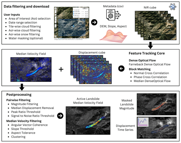
We introduce TerraTrack, an open-source tool for detecting and monitoring slow-moving landslides using Sentinel-2 data. It automates image acquisition, landslide identification, and time-series generation in an accessible and cloud-based workflow. TerraTrack supports early warning, complements interferometric synthetic aperture radar (InSAR), and offers a scalable solution for landslide hazard identification and monitoring.
Andrew D. Wickert, Jabari C. Jones, Devon Libby, Phillip H. Larson, Katherine R. Barnhart, Maximillian S. Van Wyk de Vries, and Taylor F. Schildgen
EGUsphere, https://doi.org/10.5194/egusphere-2026-1018, https://doi.org/10.5194/egusphere-2026-1018, 2026
Short summary
Short summary
Some rivers are wide. Others are narrow. Why is this, and do they change over time? To answer these questions, we developed a model and tested it against real rivers. Rivers erode bank materials to widen, but transported sediments can settle on and rebuild the banks. Rivers generally widen during large floods and narrow during moderate ones. We demonstrate how changing streamflow alters river-channel width over time, with implications for erosion and flood hazards.
Maximillian Van Wyk de Vries, Alexandre Dunant, Amy L. Johnson, Erin L. Harvey, Sihan Li, Katherine Arrell, Jeevan Baniya, Dipak Basnet, Gopi K. Basyal, Nyima Dorjee Bhotia, Simon J. Dadson, Alexander L. Densmore, Tek Bahadur Dong, Mark E. Kincey, Katie Oven, Anuradha Puri, and Nick J. Rosser
Nat. Hazards Earth Syst. Sci., 25, 1937–1942, https://doi.org/10.5194/nhess-25-1937-2025, https://doi.org/10.5194/nhess-25-1937-2025, 2025
Short summary
Short summary
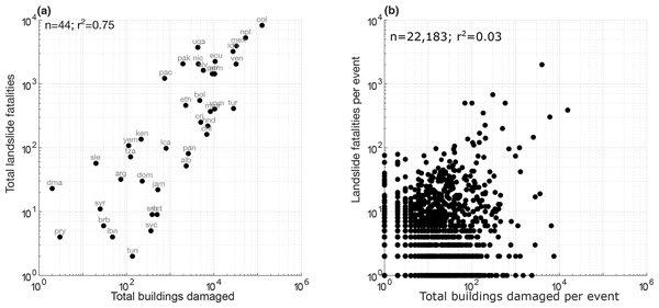
Mapping exposure to landslides is necessary to mitigate risk and reduce vulnerability. In this study, we show that there is a poor correlation between building damage and deaths from landslides, such that the deadliest landslides do not always destroy the most buildings and vice versa. This has important implications for our management of landslide risk.
Alexandre Dunant, Tom R. Robinson, Alexander L. Densmore, Nick J. Rosser, Ragindra Man Rajbhandari, Mark Kincey, Sihan Li, Prem Raj Awasthi, Max Van Wyk de Vries, Ramesh Guragain, Erin Harvey, and Simon Dadson
Nat. Hazards Earth Syst. Sci., 25, 267–285, https://doi.org/10.5194/nhess-25-267-2025, https://doi.org/10.5194/nhess-25-267-2025, 2025
Short summary
Short summary
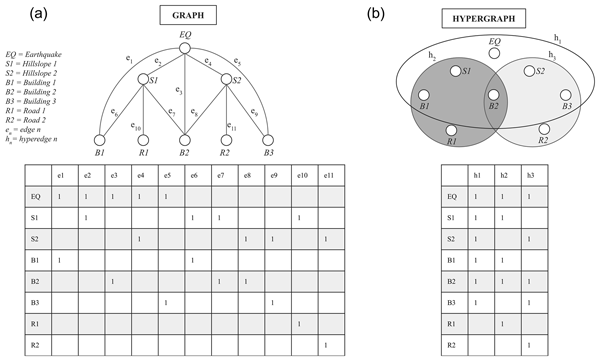
Natural hazards like earthquakes often trigger other disasters, such as landslides, creating complex chains of impacts. We developed a risk model using a mathematical approach called hypergraphs to efficiently measure the impact of interconnected hazards. We showed that it can predict broad patterns of damage to buildings and roads from the 2015 Nepal earthquake. The model's efficiency allows it to generate multiple disaster scenarios, even at a national scale, to support preparedness plans.
Maximillian Van Wyk de Vries, Tom Matthews, L. Baker Perry, Nirakar Thapa, and Rob Wilby
Geosci. Model Dev., 17, 7629–7643, https://doi.org/10.5194/gmd-17-7629-2024, https://doi.org/10.5194/gmd-17-7629-2024, 2024
Short summary
Short summary
This paper introduces the AtsMOS workflow, a new tool for improving weather forecasts in mountainous areas. By combining advanced statistical techniques with local weather data, AtsMOS can provide more accurate predictions of weather conditions. Using data from Mount Everest as an example, AtsMOS has shown promise in better forecasting hazardous weather conditions, making it a valuable tool for communities in mountainous regions and beyond.
Matias Romero, Shanti B. Penprase, Maximillian S. Van Wyk de Vries, Andrew D. Wickert, Andrew G. Jones, Shaun A. Marcott, Jorge A. Strelin, Mateo A. Martini, Tammy M. Rittenour, Guido Brignone, Mark D. Shapley, Emi Ito, Kelly R. MacGregor, and Marc W. Caffee
Clim. Past, 20, 1861–1883, https://doi.org/10.5194/cp-20-1861-2024, https://doi.org/10.5194/cp-20-1861-2024, 2024
Short summary
Short summary
Investigating past glaciated regions is crucial for understanding how ice sheets responded to climate forcings and how they might respond in the future. We use two independent dating techniques to document the timing and extent of the Lago Argentino glacier lobe, a former lobe of the Patagonian Ice Sheet, during the late Quaternary. Our findings highlight feedbacks in the Earth’s system responsible for modulating glacier growth in the Southern Hemisphere prior to the global Last Glacial Maximum.
Maximillian Van Wyk de Vries, Sihan Li, Katherine Arrell, Jeevan Baniya, Dipak Basnet, Gopi K. Basyal, Nyima Dorjee Bhotia, Alexander L. Densmore, Tek Bahadur Dong, Alexandre Dunant, Erin L. Harvey, Ganesh K. Jimee, Mark E. Kincey, Katie Oven, Sarmila Paudyal, Dammar Singh Pujara, Anuradha Puri, Ram Shrestha, Nick J. Rosser, and Simon J. Dadson
EGUsphere, https://doi.org/10.5194/egusphere-2024-397, https://doi.org/10.5194/egusphere-2024-397, 2024
Preprint archived
Short summary
Short summary
This study focuses on understanding soil moisture, a key factor for evaluating hillslope stability and landsliding. In Nepal, where landslides are common, we used a computer model to better understand how rapidly soil dries out after the monsoon season. We calibrated the model using field data and found that, by adjusting soil properties, we could predict moisture levels more accurately. This helps understand where landslides might occur, even where direct measurements are not possible.
Whyjay Zheng, Shashank Bhushan, Maximillian Van Wyk De Vries, William Kochtitzky, David Shean, Luke Copland, Christine Dow, Renette Jones-Ivey, and Fernando Pérez
The Cryosphere, 17, 4063–4078, https://doi.org/10.5194/tc-17-4063-2023, https://doi.org/10.5194/tc-17-4063-2023, 2023
Short summary
Short summary
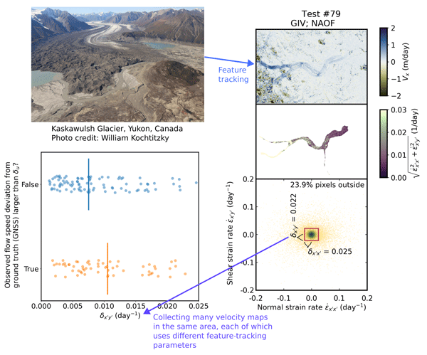
We design and propose a method that can evaluate the quality of glacier velocity maps. The method includes two numbers that we can calculate for each velocity map. Based on statistics and ice flow physics, velocity maps with numbers close to the recommended values are considered to have good quality. We test the method using the data from Kaskawulsh Glacier, Canada, and release an open-sourced software tool called GLAcier Feature Tracking testkit (GLAFT) to help users assess their velocity maps.
Maximillian Van Wyk de Vries, Shashank Bhushan, Mylène Jacquemart, César Deschamps-Berger, Etienne Berthier, Simon Gascoin, David E. Shean, Dan H. Shugar, and Andreas Kääb
Nat. Hazards Earth Syst. Sci., 22, 3309–3327, https://doi.org/10.5194/nhess-22-3309-2022, https://doi.org/10.5194/nhess-22-3309-2022, 2022
Short summary
Short summary
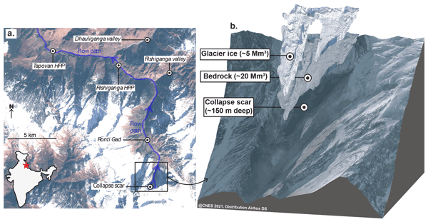
On 7 February 2021, a large rock–ice avalanche occurred in Chamoli, Indian Himalaya. The resulting debris flow swept down the nearby valley, leaving over 200 people dead or missing. We use a range of satellite datasets to investigate how the collapse area changed prior to collapse. We show that signs of instability were visible as early 5 years prior to collapse. However, it would likely not have been possible to predict the timing of the event from current satellite datasets.
Maximillian Van Wyk de Vries, Emi Ito, Mark Shapley, Matias Romero, and Guido Brignone
Clim. Past Discuss., https://doi.org/10.5194/cp-2022-29, https://doi.org/10.5194/cp-2022-29, 2022
Manuscript not accepted for further review
Short summary
Short summary
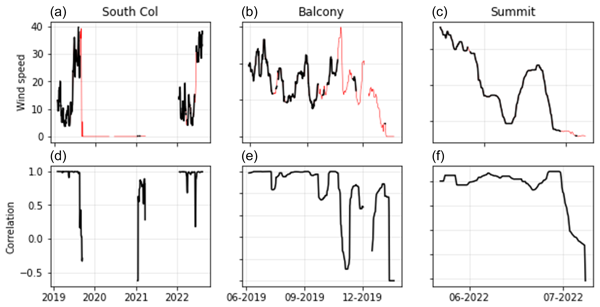
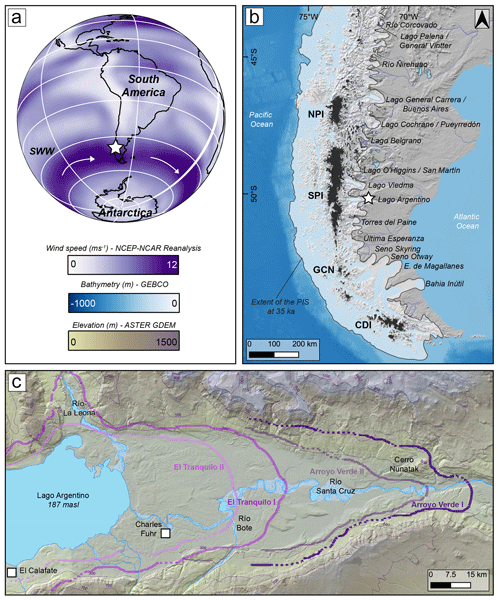
In some situations, the color of sediment records information about the climatic conditions under which it was deposited. We show that sediment color and climate are linked at Lago Argentino, the world's largest ice-contact lake, but that this relationship is too complex to be used for reconstructing past climate. We instead use this sediment color-climate relationship to show that temperature and wind speed affect sediment deposition in the summer, but not in the winter.
Cited articles
Anura3D MPM Research Community: Scientific Manual version 2022, http://www.anura3d.com (last access: 14 October 2026), 2022. a
Bouchut, F., Fernández-Nieto, E. D., Mangeney, A., and Lagrée, P.-Y.: On new erosion models of Savage–Hutter type for avalanches, Acta Mech., 199, 181–208, https://doi.org/10.1007/s00707-007-0534-9, 2008. a
Chen, Y.: Research Data: Runout Mechanism of Landslides in Alluvial Basins, Science Data Bank [data set], https://doi.org/10.57760/sciencedb.28790, 2025. a
Collins, B. D. and Reid, M. E.: Enhanced landslide mobility by basal liquefaction: The 2014 State Route 530 (Oso), Washington, landslide, GSA Bulletin, 132, 451–476, https://doi.org/10.1130/B35146.1, 2019. a
Crosta, G. B., Imposimato, S., and Roddeman, D.: Granular flows on erodible and non erodible inclines, Granul. Matter, 17, 667–685, https://doi.org/10.1007/s10035-015-0587-8, 2015. a
Cruden, D. M. and Hungr, O.: The debris of the Frank Slide and theories of rockslide–avalanche mobility, Can. J. Earth Sci., 23, 425–432, https://doi.org/10.1139/e86-044, 1986. a
Dai, Z., Wang, F., Cheng, Q., Wang, Y., Yang, H., Lin, Q., Yan, K., Liu, F., and Li, K.: A giant historical landslide on the eastern margin of the Tibetan Plateau, B. Eng. Geol. Environ., 78, 2055–2068, https://doi.org/10.1007/s10064-017-1226-x, 2019. a
Evans, S. G., Guthrie, R. H., Roberts, N. J., and Bishop, N. F.: The disastrous 17 February 2006 rockslide-debris avalanche on Leyte Island, Philippines: a catastrophic landslide in tropical mountain terrain, Nat. Hazards Earth Syst. Sci., 7, 89–101, https://doi.org/10.5194/nhess-7-89-2007, 2007. a, b
Goren, L. and Aharonov, E.: Long runout landslides: The role of frictional heating and hydraulic diffusivity, Geophys. Res. Lett., 34, https://doi.org/10.1029/2006GL028895, 2007. a
Guo, C., Zhang, Y., Montgomery, D. R., Du, Y., Zhang, G., and Wang, S.: How unusual is the long-runout of the earthquake-triggered giant Luanshibao landslide, Tibetan Plateau, China?, Geomorphology, 259, 145–154, https://doi.org/10.1016/j.geomorph.2016.02.013, 2016. a
Guo, C., Zhang, Y., Zhang, Y., Wu, Z., Li, X., Wu, R., Yan, Y., Qiu, Z., Ren, S., and Zhao, W.: Freeze-thaw cycle effects on granite and the formation mechanism of long-runout landslides: insights from the Luanshibao case study in the Tibetan Plateau, China, B. Eng. Geol. Environ., 82, 394, https://doi.org/10.1007/s10064-023-03427-6, 2023. a
Hungr, O.: Runout Analyses of Potential Landslides of South and Third Peaks: Turtle Mountain, Alberta, AER/AGS Special Report, p. 68, ISBN 978-1-4601-0171-1, 2017. a
Iverson, R., George, D., Allstadt, K., Reid, M., Collins, B., Vallance, J., Schilling, S., Godt, J., Cannon, C., Magirl, C., Baum, R., Coe, J., Schulz, W., and Bower, J.: Landslide mobility and hazards: implications of the 2014 Oso disaster, Earth Planet. Sc. Lett., 412, 197–208, https://doi.org/10.1016/j.epsl.2014.12.020, 2015. a
Iverson, R. M. and Ouyang, C.: Entrainment of bed material by Earth‐surface mass flows: Review and reformulation of depth‐integrated theory, Rev. Geophys., 53, 27–58, https://doi.org/10.1002/2013RG000447, 2015. a
Larsen, I. J., Montgomery, D. R., and Korup, O.: Landslide erosion controlled by hillslope material, Nat. Geosci., 3, 247–251, https://doi.org/10.1038/ngeo776, 2010. a
Legros, F.: The mobility of long-runout landslides, Eng. Geol., 63, 301–331, https://doi.org/10.1016/S0013-7952(01)00090-4, 2002. a
Liu, W., He, S., and Li, X.: Numerical simulation of landslide over erodible surface, Geoenvironmental Disasters, 2, 19, https://doi.org/10.1186/s40677-015-0027-4, 2015. a
Mangeney, A.: Landslide boost from entrainment, Nat. Geosci., 4, 77–78, https://doi.org/10.1038/ngeo1077, 2011. a
Mangeney, A., Roche, O., Hungr, O., Mangold, N., Faccanoni, G., and Lucas, A.: Erosion and mobility in granular collapse over sloping beds, J. Geophys. Res.-Earth, 115, https://doi.org/10.1029/2009JF001462, 2010. a
Okura, Y., Kitahara, H., Sammori, T., and Kawanami, A.: The effects of rockfall volume on runout distance, Eng. Geol., 58, 109–124, https://doi.org/10.1016/S0013-7952(00)00049-1, 2000. a
Pudasaini, S. P.: A comprehensive, unified mechanical erosion model for multi-phase mass flows, Int. J. Multiphas. Flow, 191, 105328, https://doi.org/10.1016/j.ijmultiphaseflow.2025.105328, 2025. a
Pudasaini, S. P. and Fischer, J.-T.: A mechanical erosion model for two-phase mass flows, Int. J. Multiphas. Flow, 132, 103416, https://doi.org/10.1016/j.ijmultiphaseflow.2020.103416, 2020. a
Pudasaini, S. P. and Krautblatter, M.: The mechanics of landslide mobility with erosion, Nat. Commun., 12, 6793, https://doi.org/10.1038/s41467-021-26959-5, 2021. a
Pudasaini, S. P., Mergili, M., Lin, Q., and Wang, Y.: Dynamic Simulation of Rock-Avalanche Fragmentation, J. Geophys. Res.-Earth, 129, e2024JF007689, https://doi.org/10.1029/2024JF007689, 2024. a
Reid, M.: 2014 Landslide in Washington State, Office of Communications, U.S. Geological Survey, https://www.usgs.gov/media/images/2014-landslide-washington-state-7 (last access: 14 October 2026), 2017. a
Ren, J., Qi, S., Xu, Z., Kang, W., Su, Q., and Lv, Y.: Timing of the Luanshibao Giant Landslide in eastern Tibet: the evidence from paleoseismology, IOP C Ser. Earth Env., 861, 052002, https://doi.org/10.1088/1755-1315/861/5/052002, 2021. a, b
Sassa, K., Fukuoka, H., Wang, G., and Ishikawa, N.: Undrained dynamic-loading ring-shear apparatus and its application to landslide dynamics, Landslides, 1, 7–19, https://doi.org/10.1007/s10346-003-0004-y, 2004. a, b
Sassa, K., Dang, K., He, B., Takara, K., Inoue, K., and Nagai, O.: A new high-stress undrained ring-shear apparatus and its application to the 1792 Unzen–Mayuyama megaslide in Japan, Landslides, 11, 827–842, https://doi.org/10.1007/s10346-014-0501-1, 2014. a
Shi, X., Jiang, L., Jiang, H., Wang, X., and Xu, J.: Geohazards Analysis of the Litang–Batang Section of Sichuan–Tibet Railway Using SAR Interferometry, IEEE J. Sel. Top. Appl., 14, 11998–12006, https://doi.org/10.1109/JSTARS.2021.3129270, 2021. a
Vicari, H., Tran, Q.-A., Metzsch Juel, M., and Gaume, J.: The role of dilatancy and permeability of erodible wet bed sediments in affecting erosion and runout of a granular flow: Two-phase MPM–CFD simulations, Comput. Geotech., 185, 107307, https://doi.org/10.1016/j.compgeo.2025.107307, 2025. a
Wang, F., Sun, P., Highland, L., and Cheng, Q.: Key factors influencing the mechanism of rapid and long runout landslides triggered by the 2008 Wenchuan earthquake, China, Geoenvironmental Disasters, 1, 1, https://doi.org/10.1186/s40677-014-0001-6, 2014. a
Wang, Y., Cheng, Q., Lin, Q., Li, K., and Yang, H.: Insights into the kinematics and dynamics of the Luanshibao rock avalanche (Tibetan Plateau, China) based on its complex surface landforms, Geomorphology, 317, 170–183, https://doi.org/10.1016/j.geomorph.2018.05.025, 2018. a
Wang, Y., Cui, X., Che, Y., Li, P., Jiang, Y., and Peng, X.: Identification and Analysis of Unstable Slope and Seasonal Frozen Soil Area along the Litang Section of the Sichuan–Tibet Railway, China, Remote Sens., 15, 1317, https://doi.org/10.3390/rs15051317, 2023. a
Wartman, J., Montgomery, D. R., Anderson, S. A., Keaton, J. R., Benoît, J., dela Chapelle, J., and Gilbert, R.: The 22 March 2014 Oso landslide, Washington, USA, Geomorphology, 253, 275–288, https://doi.org/10.1016/j.geomorph.2015.10.022, 2016. a
Wu, Y.-B., Duan, Z., Peng, J.-B., Zhang, Q., and Pähtz, T.: Influence of slope angle on deposit morphology and propagation of laboratory landslides, Sci. Rep., 13, 9452, https://doi.org/10.1038/s41598-023-36554-x, 2023. a
Yerro, A., Soga, K., and Bray, J.: Runout evaluation of Oso landslide with the material point method, Can. Geotech. J., 56, 1304–1317, https://doi.org/10.1139/cgj-2017-0630, 2019. a
Zeng, Q., Yuan, G., Davies, T., Xu, B., Wei, R., Xue, X., and Zhang, L.: 10Be dating and seismic origin of Luanshibao rock avalanche in SE Tibetan Plateau and implications on Litang active fault, Landslides, 17, 1091–1104, https://doi.org/10.1007/s10346-019-01319-z, 2020. a, b, c
Zhang, D., Wang, J., Qi, L., Zhang, Y., Ma, J., and Lu, G.: Initiation and movement of a rock avalanche in the Tibetan Plateau, China: insights from field observations and numerical simulations, Landslides, 19, 2569–2591, https://doi.org/10.1007/s10346-022-01917-4, 2022. a
Zhao, B., Zhao, X., Zeng, L., Wang, S., and Du, Y.: The mechanisms of complex morphological features of a prehistorical landslide on the eastern margin of the Qinghai-Tibetan Plateau, B. Eng. Geol. Environ., 80, 3423–3437, https://doi.org/10.1007/s10064-021-02114-8, 2021. a
Zhao, X., Wang, Y.-s., Wang, S.-y., Zhao, B., Zeng, L., Liu, Y., and Feng, Q.-q.: Nature and timing of a prehistoric giant landslide on the eastern margin of the Tibetan Plateau, J. Mt. Sci., 17, 1438–1451, https://doi.org/10.1007/s11629-019-5831-y, 2020. a
Zhu, L., Cui, S., Pei, X., Zhang, X., Wang, H., He, S., and Luo, L.: Investigation of the characteristics and long-runout movement mechanisms of the Luanshibao landslide on the eastern margin of the Qinghai-Tibet Plateau, Soil Dyn. Earthq. Eng., 153, 107094, https://doi.org/10.1016/j.soildyn.2021.107094, 2022. a
Zhu, L., Tang, X., He, S., Yang, Z., Liang, H., Lei, X., Luo, Y., and Zhang, L.: Geomorphology and Sedimentology of the Nyixoi Chongco Rock Avalanche and Implications for Emplacement Mechanisms, J. Geophys. Res.-Earth, 130, https://doi.org/10.1029/2024JF007666, 2025. a
Short summary
Landslides in alluvial basins can travel farther than expected. To investigate this abnormal mobility, we examined a representative event and performed mechanical tests on erodible alluvial sand. Results show that landslide impact on saturated sediment can create a fluid-like layer, enabling long travel distances. Simulations showed that the severity of this effect depends on how fragile and deformable the materials are.
Landslides in alluvial basins can travel farther than expected. To investigate this abnormal...
Altmetrics
Final-revised paper
Preprint