
the Creative Commons Attribution 4.0 License.
the Creative Commons Attribution 4.0 License.
 | 23 Oct 2026
Runout mechanism of landslides in alluvial basins with emphasis on the impact and erosion effects
Fawu Wang

Maximillian Van Wyk de Vries
Weichao Liu
Changbao Guo
Landslide runout is a critical factor in risk assessment, and runout distance is the most widely used indicator of mobility. Runout distance is determined both by the landslide's initial conditions and through interactions with erodible substrates, which can affect momentum and inertia by altering basal friction and by increasing overall flow volume, generally increasing runout distance. During erosion, the landslide mass can exert sudden impact forces on the substrate at points where the slope changes abruptly. While erosion effects have been extensively discussed in prior studies, impact forces themselves have been overlooked. Here, we combine fieldwork in SE Tibet, laboratory tests, and numerical modelling to resolve the dynamics and effect of impact loading on landslides in alluvial basins. Impact-loading ring-shear tests and numerical simulations, backed up by field evidence, indicate that impact forces can near-instantaneously generate high excess pore water pressure within a saturated substrate, reducing basal friction of the landslide mass and extending runout. As density and geometry of the impactor determine a landslide impact force, both the impactor and substrate properties, including stiffness and compressibility, control the impact duration. The interplay of these two factors can lead to different landslide runout patterns and mobilities. The findings indicate that the farthest runout does not necessarily occur under the highest impact force; rather, an appropriate impact level exists that most effectively liquefies the substrate. The findings highlight the importance of considering substrate properties for both impact and erosion during landslide runout analyses, particularly those occurring in alluvial basins.
- Article
(12198 KB) - Full-text XML
- BibTeX
- EndNote


Landslide is one of the most frequent and dangerous natural hazards in mountainous areas. A number of landslides travel unusually long runout distances, characterised by a very low apparent friction coefficient (where H denotes the drop height and L the travel distance), which cannot be explained by simple friction models (Legros, 2002). These landslides have been observed across a wide range of environments, including subaerial, submarine, and even extraterrestrial settings such as the Moon (Goren and Aharonov, 2007). The mechanisms of long runout for such landslides vary from case to case, making it challenging to forecast or mitigate associated disasters.

Figure 1Typical examples of long-runout landslides characterised by material interaction. (a) The Frank Slide traveled about 2 km covering the floodplain of Crowsnest River (image from the Frank Slide Interpretive Centre); (b) Leyte rockslide-debris avalanche with great runout distance due to undrained loading in the valley bottom (Evans et al., 2007); (c) the Oso landslide, which accelerated across the floodplain of the North Fork Stillaguamish River (Reid, 2017); (d) the Luanshibao landslide in the Maoyaba Basin, involving extensive entrainment of alluvial sediment.
Alluvial basins are widely distributed in mountainous regions. Due to their favourable topography, they often host dense populations and critical infrastructure. As depositional sites for converging water and sediment, alluvial basin floors typically feature gentle slopes and contain loose, highly saturated sediments. They are particularly susceptible to dynamic interactions with incoming landslide materials. It is well established that interaction between the landslide mass and materials along its path – through known as erosion or entrainment (Mangeney, 2011; Crosta et al., 2015; Pudasaini, 2025) – affects the mobility of the landslide by altering the volume and velocity of the landslide (Pudasaini and Fischer, 2020). Under specific conditions, this interaction can reduce basal friction, reducing energy losses and enabling the landslide to travel exceptionally long distances. It can be commonly observed that the runout of a landslide is extended by these material interactions, especially when water is involved at the same time. Examples include the well-studied 1903 Frank Slide from the east face of Turtle Mountain in Canada (Cruden and Hungr, 1986) (Fig. 1a). The detached rock covered almost 2 km of the Crowsnest River floodplain. Although evidence showed that the erosion volume was limited, it is believed that high pore water pressure was generated along the path where the landslide overrode loose and saturated soils (Hungr, 2017). Similarly, there was a disastrous rockslide-debris avalanche in February 2006 on Leyte Island, Central Philippines, whose runout distance about 3.8 km was enhanced by friction reduction due to undrained loading when the debris encountered colluvium and flooded paddy fields in the valley bottom (Evans et al., 2007) (Fig. 1b). Another case is the Oso landslide in Washington, USA, on 22 March 2014, which is situated in the North Fork Stillaguamish River valley (Wartman et al., 2016; Yerro et al., 2019) (Fig. 1c). In this case, hundreds of transient sand boils were identified, indicating that elevated pore-water pressure conditions were widespread during basal erosion of the slide (Collins and Reid, 2019). These cases highlight the significance of landslide-material interaction in understanding and predicting landslide runout.
Such material interactions cannot be overlooked in the runout assessments of landslides in alluvial basins, especially for large-volume landslides. These interactions, from material impact to shear, involve complicated physical processes and are influenced by multiple factors. These factors include geomorphological parameters, such as landslide volume (Okura et al., 2000; Larsen et al., 2010), slope inclination angle, and the thickness of the erodible bed (Iverson and Ouyang, 2015; Mangeney et al., 2010), as well as the internal geomechanical properties of the involved materials, such as water content or degree of saturation (Iverson et al., 2015; Liu et al., 2015), dilatancy that influences the pore pressure generation during landslide motion, fragility and shear strength that determines spreading of materials (Pudasaini and Krautblatter, 2021; Pudasaini et al., 2024), and permeability, which determines how long the elevated pore pressure can be sustained (Vicari et al., 2025; Zhu et al., 2025). These studies show that quantitatively modelling material interactions during landslide motion is highly challenging, both theoretically and numerically, and remains a very active research topic (Bouchut et al., 2008). Especially in alluvial basin settings, slope transitions between the basin margins and the basin floor are typically abrupt rather than gradual, which amplifies the impact effects exerted by the landslide mass. This highlights the importance of placing more emphasis on quantitatively investigating impact interactions, which commonly occur together with erosion processes (Wang et al., 2014).
In this study, we quantitatively examined the Luanshibao landslide (Fig. 1d), a prominent example of a long-runout landslide, which represents a giant prehistoric hazard that occurred in a high-elevation alluvial basin. The distinctive morphological traits, coupled with the landslide's potential threat to nearby highway and railway lines, have attracted considerable research attention. Some image-based deformation analyses have revealed that the source area of the landslide continues to undergo gradual deformation, with an annual surface displacement rate ranging from 15 to 20 mm yr−1 (Shi et al., 2021; Wang et al., 2023). Previous research on the Luanshibao landslide has primarily focused on three aspects: triggering factors, occurrence time, and movement mechanism. (1) Triggering factors: Given the substantial volume of the Luanshibao landslide, estimated to be 0.64–0.94×10⁸ m3 (Ren et al., 2021; Zeng et al., 2020), most scholars attribute its initiation to an earthquake along the Maoyaba fault, which intersects the landslide's source area (Guo et al., 2016, 2023; Zhang et al., 2022). (2) Occurrence time: Radiocarbon and 10Be exposure-age dating have been used to assess paleoseismicity of the Maoyaba fault. By synthesising these results, the landslide's occurrence time can be narrowed to between 3385 and 3248 a BP (Ren et al., 2021; Zeng et al., 2020; Zhao et al., 2020). Additional findings suggest that the Luanshibao landslide may have experienced two movement events: the first around 3.7 ka BP and the second around 2.1 ka BP (Zhao et al., 2021). (3) Runout mechanism: For understanding its high mobility, several hypotheses have been proposed. These include a “laminar-flow pattern” in alluvial sediments induced by earthquake liquefaction (Zeng et al., 2020), frictional heating effects within the sliding zone, and the presence of saturated sand layers in the Maoyaba Basin, which may have facilitated the long runout (Zhu et al., 2022).
All these aspects of the Luanshibao landslide make it a particularly interesting case for studying the mechanisms of landslides in alluvial basins. Thus, the dynamic characteristics of the landslide deposit are analysed and presented based on comprehensive field investigations. A potential motion pattern, divided into an impact phase and a runout phase, is proposed to describe and present as the typical landslide motion behaviour in alluvial basins. To elucidate the mechanical mechanisms underlying the impact phase, impact-loading ring-shear tests were conducted on sandy sediment samples. For the runout phase, numerical simulations using the Material Point Method (MPM) were employed to explain the extended travel distance of the landslide. This was followed by an extended analysis to systematically explore how material parameters determine different landslide motion patterns. The findings of this study reveal a potential mechanism that may govern long-runout landslides in alluvial basin settings. This mechanism not only contributes to a better understanding of long-runout landslide dynamics in similar topographies, but also provides valuable insights for improving landslide runout prediction and mitigation strategies.
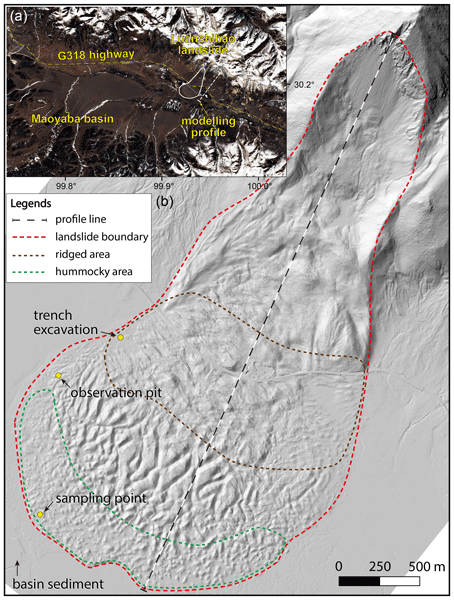
The Luanshibao landslide is an ancient long-runout landslide that occurred at the boundary of the Maoyaba Basin, located in the southeastern marginal area of the Tibetan Plateau (30°11′48′′ N, 99°55′51′′ E) (Fig. 2a). Despite being an ancient event, its boundary remains distinctly visible, characterised by an ideally flat-spread morphology within the basin. The landslide's depositional features are remarkable, including transverse and longitudinal ridges (Wang et al., 2018), a hummocky landscape (Dai et al., 2019), and X-shaped troughs (Wu et al., 2023). From the high-resolution digital surface model (DSM) model of the landslide (Fig. 2b), these distinct morphological features provide direct evidence of the dynamic impact process. The ridged area at the foot of the hill shows prominent transversal ridges, indicating the longitudinal compression during the impact. Following this, the landslide mass propagated and spread across the basin floor. Under the influence of tensional spreading forces, the deposits eventually developed into a hummocky morphology.

Figure 2Plain view of the Luanshibao landslide. (a) Location of the Luanshibao landslide within the Maoyaba basin; (b) high-resolution DSM displayed in hillshade (generated from drone-based oblique photography at a resolution of 0.3 m).
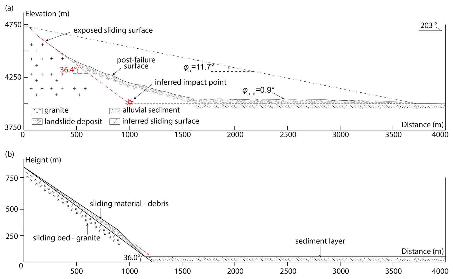
Figure 3Cross-sectional profiles of the Luanshibao landslide. (a) Longitudinal cross-section of the landslide area showing key kinematic features; (b) geometry of the numerical model cross-section constructed from an adjacent unfailed slope.
The longitudinal profile of the Luanshibao landslide show an extremely low angle of rest (Fig. 3a). The main movement direction is 203° south-westward. Based on the DSM, the total area of the landslide is calculated as about 4.316 km2, with the depositional area accounting for approximately 75 %, 3.272 km2. The elevations of the landslide crown and toe are 4857 and 4093 m, respectively, resulting in a maximum height difference of 764 m. The maximum width of the landslide in the depositional area reaches 2047 m, and the maximum horizontal sliding distance is about 3850 m. Based on the inclination feature of the exposed main scarp, it can be inferred that the landslide initially dropped along a 36.4° slope. After impacting the slope-front sediment, the landslide maintained extremely high mobility and travelled a distance of 2250 m on the flat basin plain. The overall apparent friction angle is 11.7°, while that in the depositional area is only 0.9°, which indicates the landslide's high mobility. These features raise the questions of why the Luanshibao landslide has such a high mobility and what role the interaction between landslide mass and alluvial sediment plays in determining the impressive runout.

Figure 4The Luanshibao landslide's geological and hydrogeological features. (a) Aerial photo shows the direct contact boundary of the landslide deposit and alluvial sediment; (b) a frozen landslide pond on the upper part of the landslide, indicating the hydraulic head difference within the landslide mass; (c) shallow groundwater surface exposed after removal of 0.2 m humus soil layer; (d) sandblasting formed craters at the front edge of the landslide.
The Luanshibao landslide is located in a region where the geological conditions are simple. The source area is composed primarily of biotite granite, while the depositional area lies within an alluvial basin characterised by a dense network of more than 20 tributary rivers converging into the Litang river. The Luanshibao landslide deposit rests directly on the abundant basin sediment (Fig. 4a), indicating direct interaction between the sliding mass and the underlying alluvium. Although the main scarp has gradually become covered by weathered granite debris over the long period since the landslide occurrence, it remains clearly identifiable in the landscape (Fig. 4b).
A trench was excavated to investigate the internal structure of the landslide deposits (location marked in Fig. 2). The trench profile, located near the right boundary of the landslide close to the highway, reveals that the interface between the landslide material and the underlying sediment is no longer distinguishable because of their similar mineral composition and the effects of long-term post-depositional processes. As a result, the profile can only be divided into two visually distinct layers. The top layer consists of humus soil, approximately 0.2 m thick, which provides nutrients for the basin's grassland. The lower layer, which is inferred to control the runout mechanism, is composed of thick, homogeneous sandy soil, consistent with the composition of the basin sediment. An observation pit was further excavated along the landslide boundary to investigate the groundwater conditions within the landslide area (location marked in Fig. 2). As shown in Fig. 4c, the groundwater surface was exposed after removal of the overlying humus soil, indicating that the groundwater level here is extremely shallow.
In addition to the shallow groundwater table observed in the pit, parts of the landslide deposit exhibit signs of localised pressurisation. Sandblasting phenomena are widely observed in the alluvial sediment near the front edge of the landslide, where fine-grained sandy layers are intermittently ejected by water pressure at intervals of several metres, forming small “craters” (Fig. 4d). This indicates that the alluvial sediments in certain areas of the Maoyaba Basin are under conditions with elevated pore water pressure. The phenomenon is especially pronounced along the landslide boundary and is most likely attributed to the presence of numerous water ponds distributed across the landslide area. These ponds suggest substantial groundwater seepage from the surrounding slopes, driven by the hydraulic head differences within the basin. Among them, the largest pond is located at the head of the landslide, with its surface frozen during the day of investigation (Fig. 4b). The high permeability of the granitic sandy materials, combined with the region's frequent freeze-thaw cycles and abundant precipitation, facilitates groundwater accumulation and the formation of a confined sediment layer within the basin, which provided a special erosive media for influencing the landslide runout.
This study is grounded in the analysis of the kinematic features of the Luanshibao landslide obtained from field investigations. These investigations included the establishment of a drone-based DSM, trenching within the landslide deposit, and material sampling in the erosive layer. To discuss the impact and erosion effects of the landslide motion separately, we conceptualised the motion after initiation as comprising two phases: the impact phase occurring at the slope foot and the runout phase taking place across the flat basin. For the impact phase, impact-loading ring-shear tests were carried out to examine the responses of pore water pressure and shear strength under varying levels of dynamic impact. Subsequently, numerical simulation were conducted via MPM for both impact and runout phases to elucidate how the variations in material properties influence the impact process, leading to different runout characteristics. A more detailed description of methodologies and parameters employed is provided in the following sub-sections.
3.1 Impact-loading tests in undrained ring-shear
Impact-loading ring-shear test is used to geotechnically simulate the soil behaviour impacted by dynamic normal and shear stresses. Figure 5a shows a conceptual model of a landslide impacting the basin material, and Fig. 5b presents the corresponding theoretical stress path of the impacted specimen during this process. Considering a block of sliding mass detaching from an elevated slope, the runout process can be divided into three stages, including the initial stage, the impact stage, and the sliding stage. Taking an element at the rupture surface within a unit soil column for force analysis, in the initial stage, the sediment is subjected to gravitational load determined by its buried depth h0, bulk unit weight γ, and dip angle of the basin surface θ, which is normally small. As the sliding mass descends from a higher elevation, it imposes an impact force Pd on the sediment surface along the direction of the sliding surface, which has an angle α with the basin floor. This force induces increases in normal and shear stresses through stress propagation within the sediment layer. In the laboratory tests, this process is simplified by applying a dynamic normal stress Δσd and a dynamic shear stress Δτd to the specimens, thereby mimicking the effect of the impact load. In the sliding stage, the sliding mass progressively disintegrates and continues to slide along the basin surface until final deposition, at which point the accumulated material exerts an additional static load Ps due to its self-weight on the underlying sediment. This loading is also simplified in the tests as additional stress components, expressed as Δσs and Δτs.
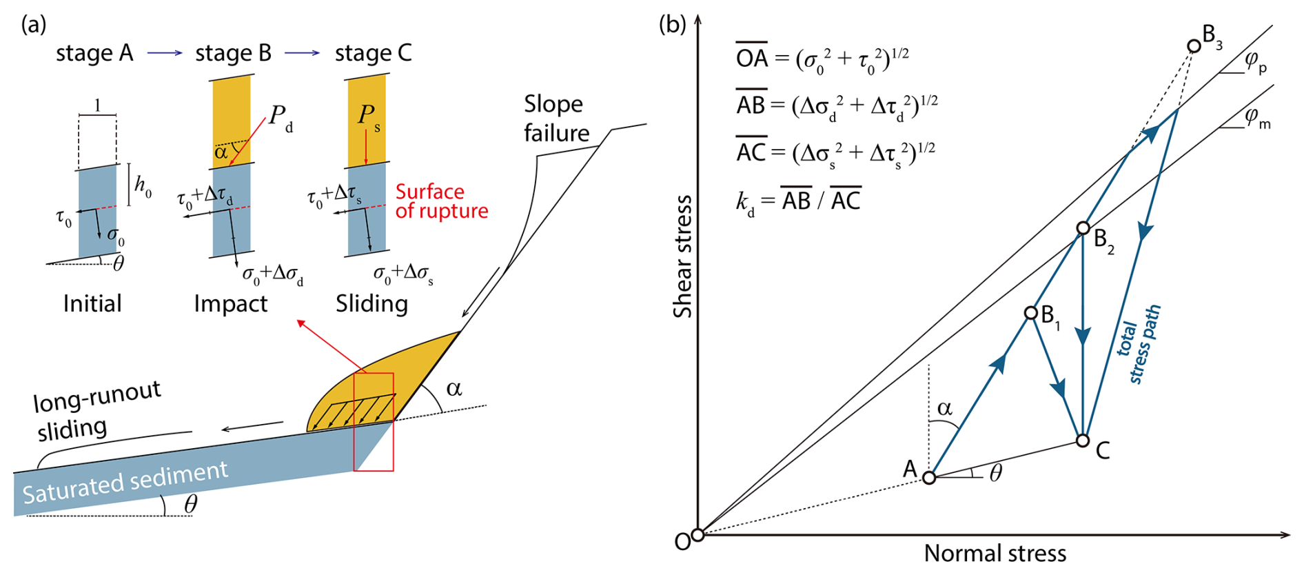
Figure 5Schematic diagram of the landslide impact effect discussed in this study. (a) Three-stages model of landslide impact-runout process (h0 denotes the assumed burial depth of the rupture surface within the sediment layer; α denotes the angle between the initial sliding surface and the sediment surface; θ denotes the slope angle of the sediment layer); (b) theoretical stress paths of the impact-loading ring-shear tests (modified from Sassa et al., 2004) (φp denotes the peak friction angle; φm denotes the mobilised friction angle). Note that θ is not necessarily identical in panels (a) and (b), as the slope of the rupture surface within the sediment layer may differ from the sediment surface slope in real cases.
The stress paths in Fig. 5 show the stress state transitions among these stages, illustrating the mechanical features such as shear resistance and pore water pressure of the sediment specimens in response to the impact load. The total stress path, depicted in blue, starts at point A (initial stage), rapidly transits to point B (extreme stress state during the impact stage), and ends at point C (the beginning of the sliding stage, while the specimen may keep shearing under a very small driving force due to its low shear resistance). Line AB, which has an angle α with the vertical direction, represents the stress increase caused by the impact load, that is and . Line AC, with a slope of θ, signifies the stress change caused by the weight of a unit column of overlying material between the initial and final stages, that is and .
Considering the theorem of impulse, the magnitude of impact load is controlled by the velocity of the sliding mass and the duration of impact. In reality, this impact magnitude cannot be inferred simply from height difference and volume. It also depends on landslide material properties, including rock or soil types, fragility, brittleness and so on, which strongly influence both the impact effect and subsequent runout behaviour. In the ring-shear tests, based on the peak value of the impact load, the loading path can be presented in three different ways: line AB1C, line AB2C, and line AB3C. These correspond to three different positions of the peak stress state relative to the failure lines: point B1 lies below the mobilised failure line, point B2 between the mobilised and peak failure lines, and point B3 above the peak failure line. Each case exhibits a different unloading path, where the normal stress either increases or decreases after the impact peak, affecting shearing behaviour during the following sliding stage. To quantify these impact modes, we introduced the dynamic coefficient (kd) as the ratio of impact pressure magnitude to static pressure magnitude as (Sassa et al., 2004).
Table 1Experimental conditions for impact-loading tests in ring-shear.
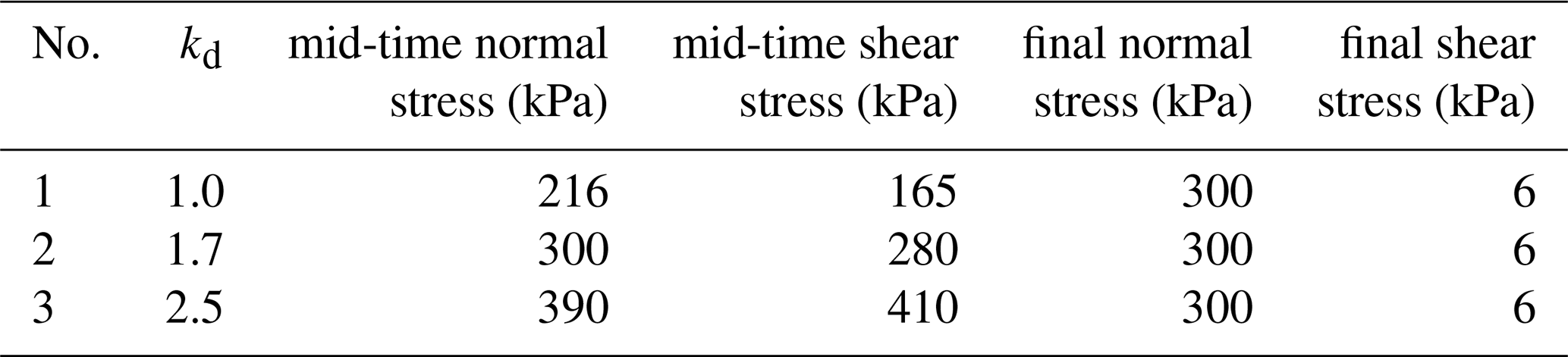
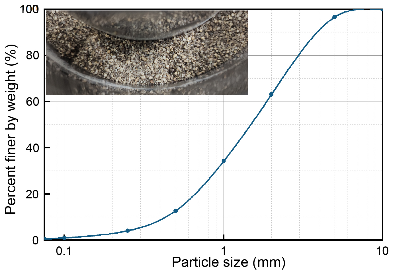
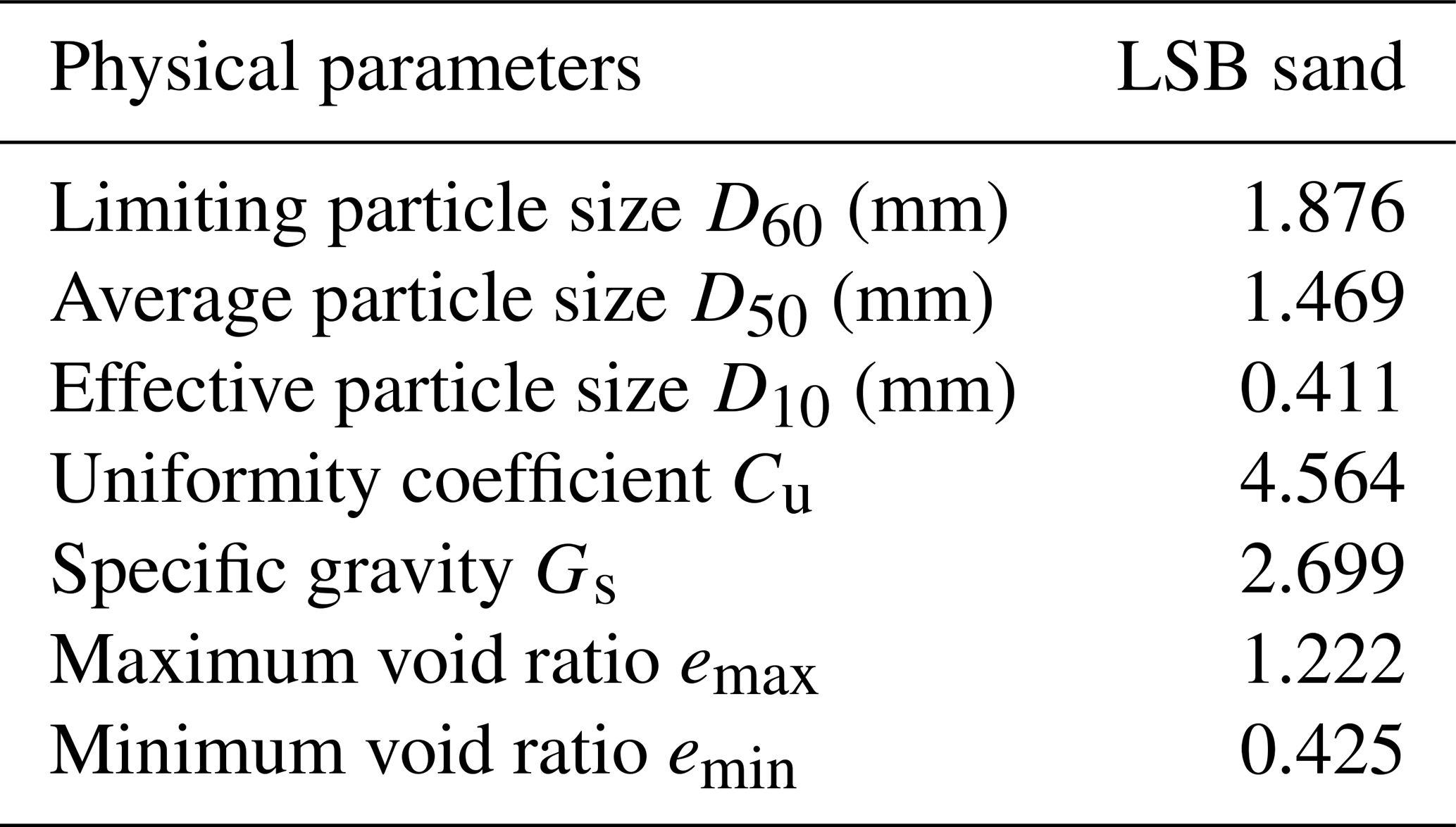
In this study, we used three different levels of kd in the ring-shear tests with a fixed impact duration of 5 s. The load parameters used are listed in Table 1. Undrained condition is employed, because the rapid process of the landslide impact does not give sufficient time for pore pressure dissipation. The ICL-2 ring-shear apparatus (Sassa et al., 2014) was employed. This apparatus is capable of maintaining undrained condition during dynamic shearing and able to provide theoretically infinite shear distance, making it particularly suitable for investigating the rapid mechanical response of shear zone material during landslide processes. The samples, named LSB sand (Fig. 6), were collected from the alluvial sediment layer in the excavated trench in the landslide depositional area. All the tests were performed under saturated conditions (The process of specimen preparation is described in detail in the Appendix A). Basic physical and mechanical properties of LSB sand were tested in accordance with Chinese Geotechnical Testing Standards (GB/T 50123-2019). The results of these tests are summarised in Table 2.
3.2 Impact-runout modelling by material point method
To further investigate how the duration of materials interaction, which is influenced by the material properties, controls both the impact and following runout processes, numerical simulations were conducted to quantitatively describe the entire runout process under different scenarios. Since Luanshibao landslide is an ancient case, it is difficult to precisely reconstruct the post-failure topography. Therefore, the model geometry (Fig. 3b) was established using the cross-sectional profile of an unfailed slope adjacent to the Luanshibao landslide (profile line is depicted in Fig. 2). The model has a total height of 850 m and includes a 50 m thick sediment layer. The slope of the sliding surface is 36°, consistent with the exposed surface of rupture.
Based on the observations that groundwater level was extremely shallow in the landslide area and to simplify the model, the materials used in the simulations except for the bedrock were all considered under saturated condition. For this case, a two-phase MPM for saturated soil framework was used (Anura3D MPM Research Community, 2022). This framework follows the mixture theory that uses porosity to divide the contents of solid and liquid, and the porosity update was not manually controlled through the simulations but derived based on the evolution of material volume temporally and spatially. This framework describes the coupling problem with four equations, in which the subscript “S” stands for the solid phase and “L” stands for the liquid phase. They are two conservation equations for the mixture (Eqs. 1 and 2), one momentum equation for the liquid (Eq. 3), and one equation for the solid skeleton, depending on the choices of linear elastic model or Mohr-Coulomb model in this study.
In those equations, εL is the effective volumetric strain, n is the porosity of the mixture, v is the velocity vector, ρ is the density, g is the gravitational acceleration, and k is the isotropic Darcy permeability which is controlled by intrinsic permeability and viscosity of the liquid in the simulations.
Table 3Material parameters adopted in the impact-runout simulations.
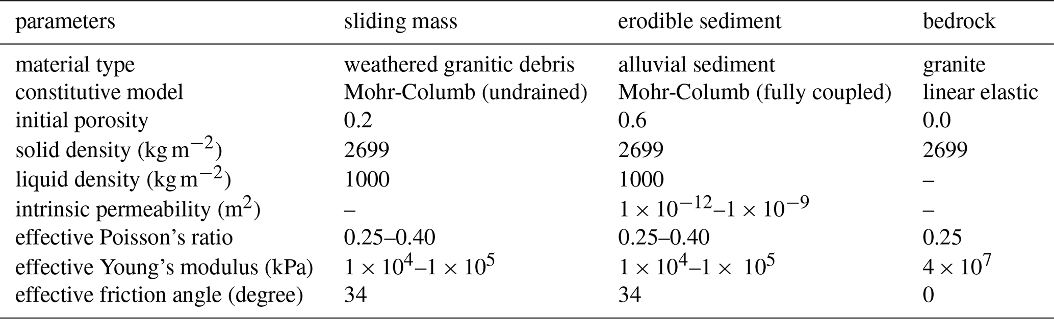
In this study, the base of the slope described in Fig. 3b was considered to be consist of granite bedrock, described by a linear elastic model. Both the sliding material and the erosive sediment layer are described using Mohr-Coulomb model, with effective friction angle determined from the prior monotonic ring-shear tests (see Appendix for details). The sliding material is considered as weathered granitic debris which should be relatively denser than the erosive layer that primarily composed of loose alluvial sediment. Based on the hydrogeological features from field observation (introduced in Sect. 2), both materials are modelled as in a saturated state. To comprehensively evaluate the influence of material properties on landslide impact and the following runout patterns, two parameters of both sliding material and erosive sediment, including Young's modulus E and Poisson ratio ν, are varied and tested to see how the stiffness and compressibility of materials contribute to the impact depth, velocity, and final runout. The numerical simulation scenarios and the corresponding parameter values are list in Table 3.
Based on the field observation described above, a key unresolved question is: why did this landslide exhibit such high mobility? This uncertainty also raises our interest in understanding the role of pore pressure within the erodible sediment. In addition to water, are there other factors influencing the interaction between the landslide mass and the alluvial sediment that might account for variations in mobility and runout behaviour? A quantitative explanation is essential for answering these questions. Building on the previous analysis of the landslide's kinematic characteristics, we conducted a series of physical and numerical experiments to investigate the effects of impact-induced interaction on long-runout landslides in similar basin environments. The results of these experiments are presented in detail below.
4.1 Shear resistance behaviour in the impact-loading ring-shear tests
The ring-shear tests began with monotonic shear tests to evaluate the fundamental strength properties of the material (described in detail in the Appendix). Under fully drained conditions, the mobilised friction angle of the sample was found to be approximately 34°, and this value was subsequently used to plot the failure lines in the following tests. Under undrained conditions, the maximum excess pore water pressure ratio ru, defined as the ratio of pore water pressure generated during shearing to the total normal stress, stabilised at approximately 0.83 after a shearing distance of 1000 mm. This value represents the liquefaction potential of the LSB sand under monotonic shearing conditions. For comparison, Fig. 7 presents the results of impact-loading ring-shear tests conducted under three different dynamic coefficients. Figure 7a–c display the applied impact signals corresponding to kd values of 1, 1.7, and 2.5, respectively. All samples were consolidated under the same initial stress conditions, simulating a depth of approximately 6 m within the sediment layer. In each test, the impact load comprised two stages: a loading stage from 10 to 15 s, followed by an unloading stage from 15 to 20 s. The loading modes can be categorized into three types, as described in the previous section, depending on whether the normal stress pulse increases, decreases or remains stable after reaching the peak stress at 15 s.
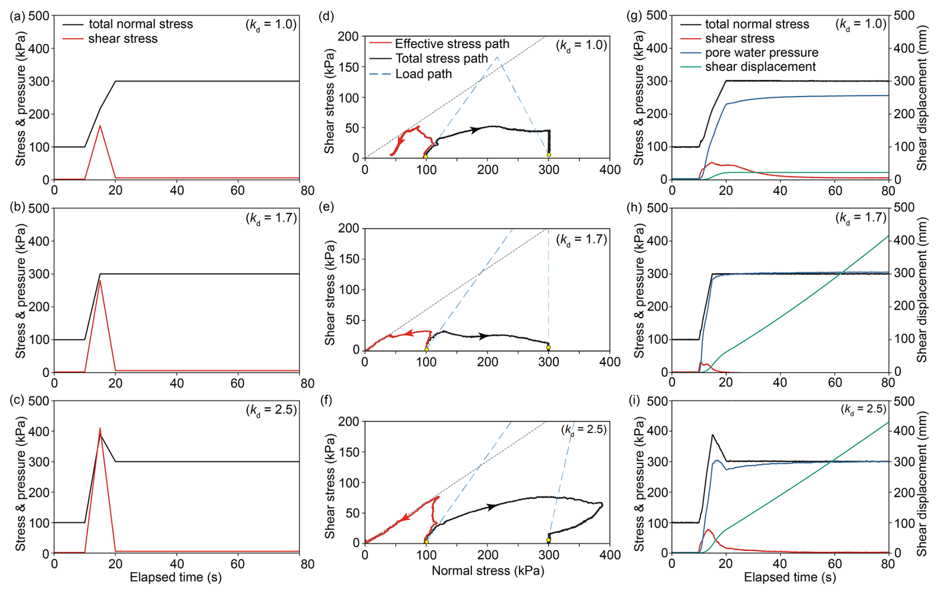
Figure 7Results of impact loading tests. (a–c) Input signals of the impact loading modes; (d–f) actual response of the stress line under impact loading; (g–i) mechanical response versus elapsed time under the impact loading.
Figure 7d–f present the results of these tests in stress path space. The Total Stress Path (TSP) is shown in black, while the Effective Stress Path (ESP) is shown in red. At the beginning of each test, both TSP and ESP initially move upward together, starting from 100 kPa in normal stress and 2 kPa in shear stress, in response to the applied impact load. Shortly afterwards, pore water pressure begins to build within the specimens, causing the TSP and ESP to diverge. In the test with a dynamic coefficient kd=1.0, the ESP quickly touches the failure line but then moves downward, entering a more stable state due to a combination of decreasing shear stress and increasing normal stress during the unloading stage. In contrast, for kd=1.7 and kd=2.5, the ESP continues to follow the failure line after initial contact, eventually driving the specimens into a fully liquefied state. Figure 7g–i illustrate the temporal evolution of total normal stress, shear stress, pore water pressure, and shear displacement during these tests. Under kd=1.0, the sample undergoes only a few millimetres of displacement during the impact stage. As the test transitions into unloading, the normal stress continues to rise, quickly halting further motion. The final excess pore water pressure ratio ru stabilises at approximately 0.74, indicating that under this condition, the impact load was insufficient to generate the pore pressure required to trigger long-runout motion. In contrast, for kd=1.7 and kd=2.5, the excess pore water pressure ratios exceed the value of liquefaction potential identified under monotonic shearing. Unlike the monotonic tests, these samples experience complete strength loss, and the resulting motion continues without interruption. Interestingly, under kd=1.7, it takes roughly 20 s for the sample to reach complete strength loss, while it takes about 60 s for kd=2.5. This observation indicate that an optimal level of impact stress may exist that maximises the liquefaction efficiency within the erodible layer.
4.2 Variable runout patterns in the numerical simulations
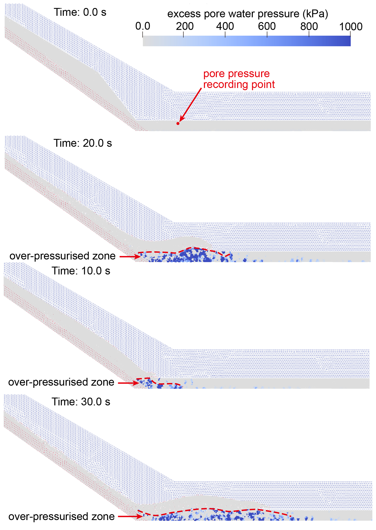
The simulations of the impact and runout phases were performed using a two-dimensional cross-sectional model, beginning with a benchmark case. In this benchmark scenario, the Young's modulus is set to 1×10⁴ kPa for the landslide mass and 1×10⁵ kPa for the sediment layer, while Poisson's ratio is fixed at 0.35 for both materials. These parameter choices reflect the geological context of the Luanshibao landslide, treating the landslide mass as fractured granitic gravel and the underlying sediment as sandy soil. All subsequent simulations, involving various combinations of material properties, are compared to this benchmark to investigate their influence on the impact dynamics and runout behaviour. Figure 8 shows the displacement field throughout the process, illustrating the interaction between the sliding mass and the saturated erodible sediment. After initial failure, the landslide mass descends along the granitic sliding surface and impacts the sediment layer. Upon impact, the sliding mass penetrates approximately 10 m into the sediment, entraining sediment material into the moving body. This entrainment promotes continued forward motion across the relatively flat topography of the alluvial basin, effectively reproducing the long-runout pattern observed in the Luanshibao landslide. Figure 9 illustrates the evolution of excess pore water pressure during the impact-runout phase. Excess pore water pressure is generated almost instantaneously at the moment of impact, particularly near the slope toe in both the upper and basal zones of the landslide. This pressure continues to evolve as the landslide progresses, forming a low-friction basal layer that facilitates sustained motion.
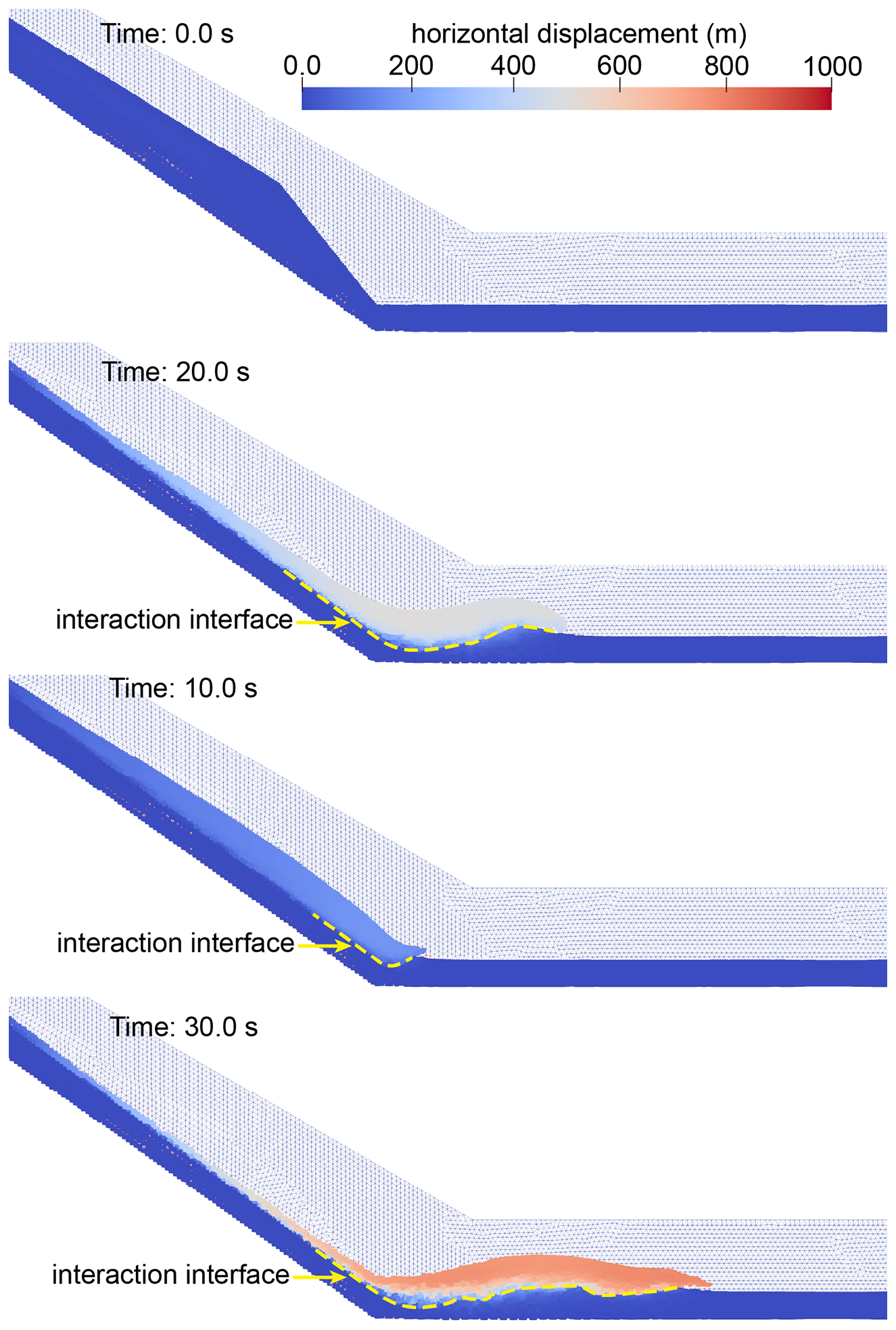
Figure 8Simulation result of the benchmark scenario shown in the horizontal displacement field.
To investigate the influence of material properties in both the sliding mass and the erodible sediment layer, a series of comparison simulations were conducted by varying the Young's modulus (from 1×10⁴ to 1×10⁵ kPa) and Poisson's ratio (from 0.25 to 0.40). The results indicate that even slight changes in these parameters can lead to significant variations in landslide mobility and deposition patterns. Figure 10 presents polynomial-fitted curves illustrating how landslide mobility, represented by final sliding distance, and impact depth, respond to changes in these parameters. As shown in Fig. 10a and b, increasing the stiffness of the sliding mass leads to a noticeable reduction in mobility, accompanied by a significant increase in impact depth. In contrast, increasing the stiffness of the erodible sediment layer results in only a slight increase in mobility up to a modulus of approximately 7 × 10⁴ kPa, after which the mobility plateaus. Meanwhile, the impact depth shows a sharp decline with increasing stiffness of the sediment layer. Figure 10c and d indicate that the variations in the properties of the erodible sediment have limited influence on overall landslide dynamics. However, decreasing the compressibility of the sliding mass leads to a marked decrease in final runout distance. Interestingly, the impact depth exhibits a hyperbolic trend with respect to Poisson's ratio, reaching a minimum near a ratio of approximately 0.31. In summary, stiffness and compressibility exert opposing influences on impact and runout behaviours in the two materials, except that the effect of Poisson's ratio on impact depth appears to follow a non-monotonic pattern.
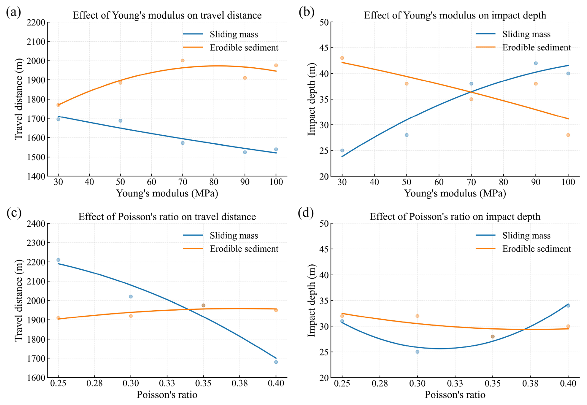
Figure 10Influence of elastic parameters on the dynamic interaction between the sliding mass and erodible sediment. (a) Final travel distance influenced by Young's modulus; (b) final travel distance influenced by Poisson's ratio; (c) impact depth influenced by Young's modulus; (d) impact depth influenced by Poisson's ratio. In each simulation scenario, all parameters other than the one being varied are kept identical to those in the benchmark case.
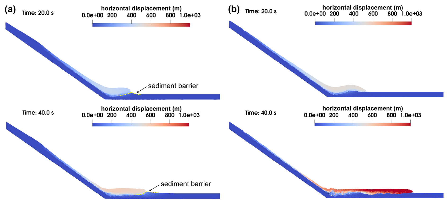
Figure 11Two possible runout patterns caused by different material properties. (a) A stiffer sliding mass with Young's modulus of 1×10⁵ kPa; (b) a more deformable sliding mass with a Poisson's ratio of 0.25.
Here, we highlight two simulation cases that exhibit the most distinct runout behaviours compared to the benchmark scenario. Figure 11a presents the case in which the sliding mass has a higher Young's modulus of 1×10⁵ kPa. In this scenario, a stiffer landslide mass transfers most of its momentum into penetrating the sediment layer, reaching an impact depth of approximately 40 m. Instead of entraining sediment material, the stiff mass pushes it forward, forming a barrier in front of the landslide that hinders further motion. By contrast, a markedly different behaviour is observed when the sliding mass exhibits higher compressibility, as shown in Fig. 11b for a Poisson ratio of 0.25. In this case, the sliding mass disintegrates upon impact with the sediment surface, resulting in a shallower impact depth of approximately 31 m. Although the amount of entrained sediment is moderate, entrainment prevails over penetration as the dominant interaction mechanism, enabling the landslide to bypass barrier formation and maintain its forward movement. These contrasting outcomes suggest that the stiffness and compressibility of both the sliding mass and the alluvial sediment play critical roles in governing the dynamics of impact interaction and the subsequent runout pattern.
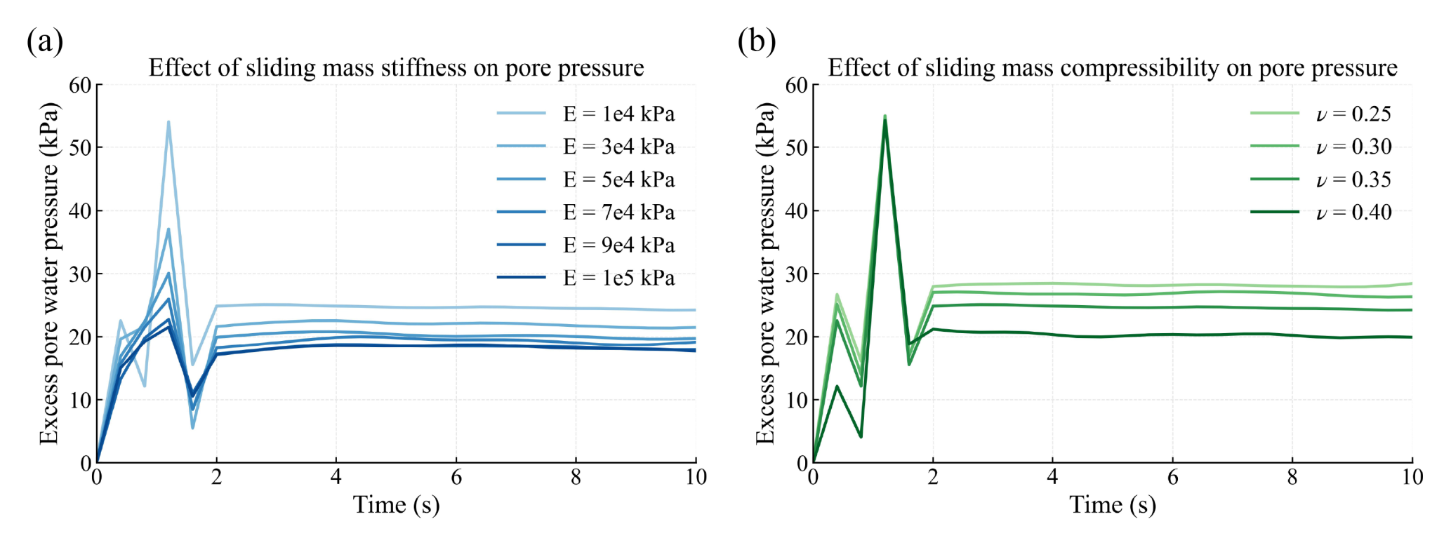
Figure 12Pore pressure response under varying impact duration determined by elastic parameters. (a) Excess pore pressure response at a representative material point subjected to impacts from sliding masses with different stiffness values; (b) excess pore pressure response at the same point for sliding masses with different compressibility.
These analysis shows that variations in the elastic parameters of the materials involved in the landslide impact process significantly influence landslide mobility, primarily through their control on impact duration. To quantitatively examine the pore pressure response under different impact situations, we select a material point located in the shallow layer of the erodible sediment near the impact region (initial coordinates: (1400, 40). The excess pore pressure responses are presented in Fig. 12. As shown in Fig. 12a, a less stiff impactor generates higher excess pore pressure. This is attributed to the fact that a stiffer material shortens the impact duration, leading to a more impulsive interaction. Figure 12b shows that the pore pressure response is less sensitive to the variation of Poisson's ratio in terms of peak values. However, it can still be observed that increasing the compressibility of the sliding mass reduces the minimum pore pressure values during the process. It should be noted that the selected material point moves during the simulation. Therefore, the recorded data does not correspond to a fixed spatial location and can not fully represent the spatial variability of the pore pressure field. Nevertheless, it still provides useful information of the sensitivity of the modelled system.
Long-runout landslide patterns similar to the Luanshibao landslide are commonly observed in alluvial basins and floodplains located in high-elevation regions. These areas are characterized by frequent faulting and seismic activity, which can trigger internal failure within high-elevation rock masses; relatively young rock exposure ages in landslide source areas, often associated with brittle mechanical behaviour; extremely thin weathered layers covering steep slopes; and the accumulation of loose, highly saturated materials, including alluvial sediment, landslide debris, and glacial moraines in adjacent low-lying basins. Material released from elevated positions tends to travel over bare rock slopes with minimal energy loss, making the impact interaction at the slope foot a non-negligible process. Given these conditions, it is crucial to explore impact mechanisms for the purpose of a more accurate runout assessment. This impact process involves the disintegration of the sliding mass and modifies the mechanical behaviour of the underlying materials. Specifically, changes in pore water pressure, shear strength, and basal friction during impact significantly influence landslide mobility. Therefore, a detailed investigation of how material properties govern the mechanical response and the ultimate runout pattern is essential.
In the context of high-elevation landslides occurring in alluvial basins, erodible sediment - potentially incorporated into the landslide mass through material interactions - can experience higher excess pore water pressure under impact conditions than under monotonic rapid shearing. This elevated pore pressure is likely attributable to the impact-induced disruption of the sediment's initial consolidated structure, thereby increasing its susceptibility to liquefaction. According to the theorem of impulse, the change in the impactor's momentum is equal to the product of the impact force and the impact duration, while the magnitude of the impact load depends on the landslide mass and its velocity at the moment of impact. For a given landslide geometry, the mass at impact is fixed. However, the impact duration and velocity are related to the initiation mechanism and propagation processes, where material properties play a significant role. To investigate the influences of material properties on the mechanical response of the sediment layer, we set a constant impact duration while varying the dynamic coefficient. This coefficient represents the level of impact load determined by internal material properties in real-world scenarios. The applied impact load can be classified into three modes, as illustrated in Fig. 5, distinguished by how the normal stress evolves after reaching its peak.
The results of ring-shear tests indicate that those different impact modes can lead to distinct soil responses in terms of effective stress path, as shown in Fig. 13. At the lowest impact level, the effective stress path only reaches the failure line and slightly drops back, and thus does not trigger a catastrophic slide within the specimen, as represented by path AD1. The other two impact modes both eventually lead the specimen to a state of complete liquefaction, but through different mechanisms. A moderate impact tends to induce structure-related pore pressure generation, with the stress path AD2 curving directly toward the origin. In contrast, a higher impact level initially destroy the soil structure, driving the path to the failure line and initiating shear deformation within the specimen. Subsequent pore pressure generation then causes the path evolve toward the origin along the failure line, as shown by path AD3. These two failure modes present different liquefaction efficiencies, as structure-induced pore pressure generation occurs more rapidly than that associated with shear-induced grain crushing. This observation suggests that, in real landslide cases, the final mobility of the sliding mass is not solely positively correlated with the impact intensity, but is also strongly influenced by the failure mechanisms govern by the specific impact modes.
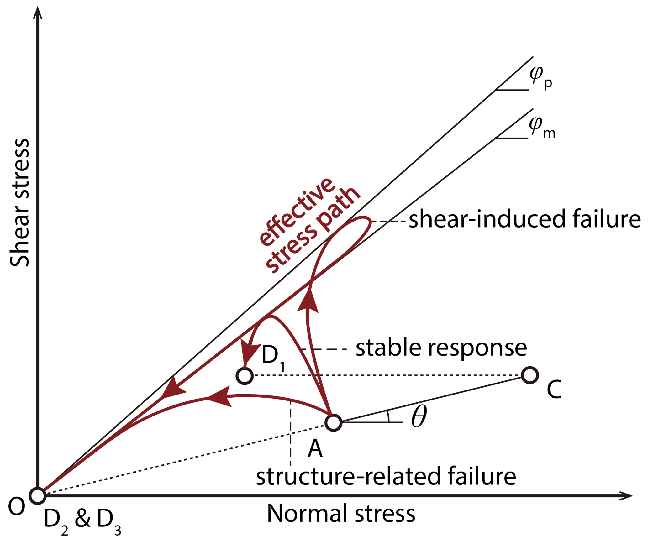
Figure 13Effective stress paths for three impact responses induced by varying impact coefficient levels.
In the numerical simulations, we investigated the effect of impact duration on landslide mobility by indirectly varying materials properties. In addition to the two elastic parameters discussed previously, it should be acknowledged that other factors, such as material permeability and initial porosity, may also significantly affect landslide dynamics. To assess their potential roles, we also conducted a series of parallel simulations, in which the intrinsic permeability of the erodible layer was varied from 1 × 10⁻¹⁰–1 × 10⁻¹² m2, and the initial porosity was varied from 0.2 to 0.6. However, these variations did not produce pronounced changes in landslide mobility or runout patterns, particularly when compared with the sensitivity observed for the elastic parameters. This does not imply that these factors are unimportant in controlling landslide behaviour. Their influence appears to be less significant for the present case, likely due to the specific spatial scale and temporal duration of the simulated event. Their roles in modulating pore-pressure diffusion, impact dynamics, and erosion processes remain important topics for further investigation in more studies.
This study investigates the runout mechanisms of landslides in alluvial basins, highlighting the role of landslide impacts on saturated basin sediments in initiating erosion processes during runout. Taking the Luanshibao landslide as an example, numerous landslide ponds were observed in the landslide area, along with the widespread sandblasting phenomenon along the landslide boundary, indicating the active groundwater seepage within the landslide mass. This suggests that both the landslide material and the basin sediment were likely in a highly saturated state at the time of failure. The impact of failed high-elevation mass could generate excess pore water pressure that was difficult to dissipate promptly at the interface between the sliding mass and the underlying sediment. This excess pore water pressure at the sliding interface significantly reduced the basal friction and sustained long runout.
However, results from both ring-shear tests and numerical analyses reveal that the interaction between the impacting landslide mass and the basin sediment does more than simply extend the landslide's runout distance. Due to differences in landslide volume and in the properties of both the impactor and substrate, different motion patterns can emerge. The stiffness and compressibility of these materials strongly influence the peak impact force, which correspondingly alters the final runout distance and pattern. Loose and brittle landslide material tends to disintegrate upon impacting saturated sediments and travel farther over weak basal layers, while intact and stiffer masses penetrate sediments and lose mobility.
Such impact-induced processes should not be overlooked in mobility analyses, especially in alluvial basin environments characterised by abundant groundwater and sharp changes in slope angle at the basin boundary. The current omission of this impact factor in numerical models could lead to a misjudgment of hazard risks. Therefore, it is necessary to develop mathematical models that more precisely reflect the impact effect for the future improvement of landslide numerical simulations. In addition, recognising the significance of impact force levels and the properties of erodible materials can provide useful guidance for researchers and practitioners working on risk analysis and mobility estimation. In particular, incorporating parameters such as slope angle changes and the mechanical state of regional materials may be necessary when conducting hazard assessments.
The samples preparation process and the results of proceeding monotonic tests are introduced here. Tests were performed on the sediment samples under both shear rate-controlled and impact loading conditions in this study. All samples were loosely compacted into the shear box and consolidated under the specified stress. Firstly, drained tests were conducted to determine the internal friction angle of the sample at the critical state (also known as the mobilized friction angle, as it reflects the mechanical behaviour of the shear zone during landslide motion). In the drained test, the normal stress was modulated to change linearly while the sample is under shearing, allowing the mobilized failure line to be derived from the moving stress path. The mobilized friction angle of the sample was found to be approximately 34°.
After that, direct shearing and impact-loading tests were carried out on saturated samples under undrained condition. Each sample was first saturated using a method combining vacuuming and carbon dioxide displacement. The saturation degree was then verified using the BD value, which is the ratio of the increase in excess pore water pressure to the applied normal stress. The BD values of all samples in this study were confirmed to be above 0.95, indicating full saturation. Following the saturation process, the samples were consolidated under calculated normal and shear stresses, simulating the stress state related to gravitational forces in the initial rested stage. Once consolidation was complete, the next loading process commenced.
Figure A1 illustrates the stress path of the shear rate-controlled tests. The dashed line in Fig. A1a represents the mobilized failure line. The data reveal that the LSB sand exhibited an increase in pore water pressure and a loss of strength after being sheared over a distance of 1000 mm under normal stresses of 300, 400, and 500 kPa. After sufficient shearing distance, the excess pore water pressure generated within the sample stabilized at a constant value. The results indicate that the maximum excess pore water pressure ratio achievable by the LSB sand is approximately 0.83. This final excess pore water pressure ratio is influenced by the mineral composition of the soil. The final apparent friction angle of the sand sample was reduced to only 2.2°, a condition that significantly facilitates the long-distance movement of the sliding mass. It is noteworthy that the LSB sand sample did not achieve complete liquefaction through monotonic shearing. Unlike vibration-induced liquefaction, the degree of shear liquefaction in sand samples depends on their mineral composition and particle size distribution.
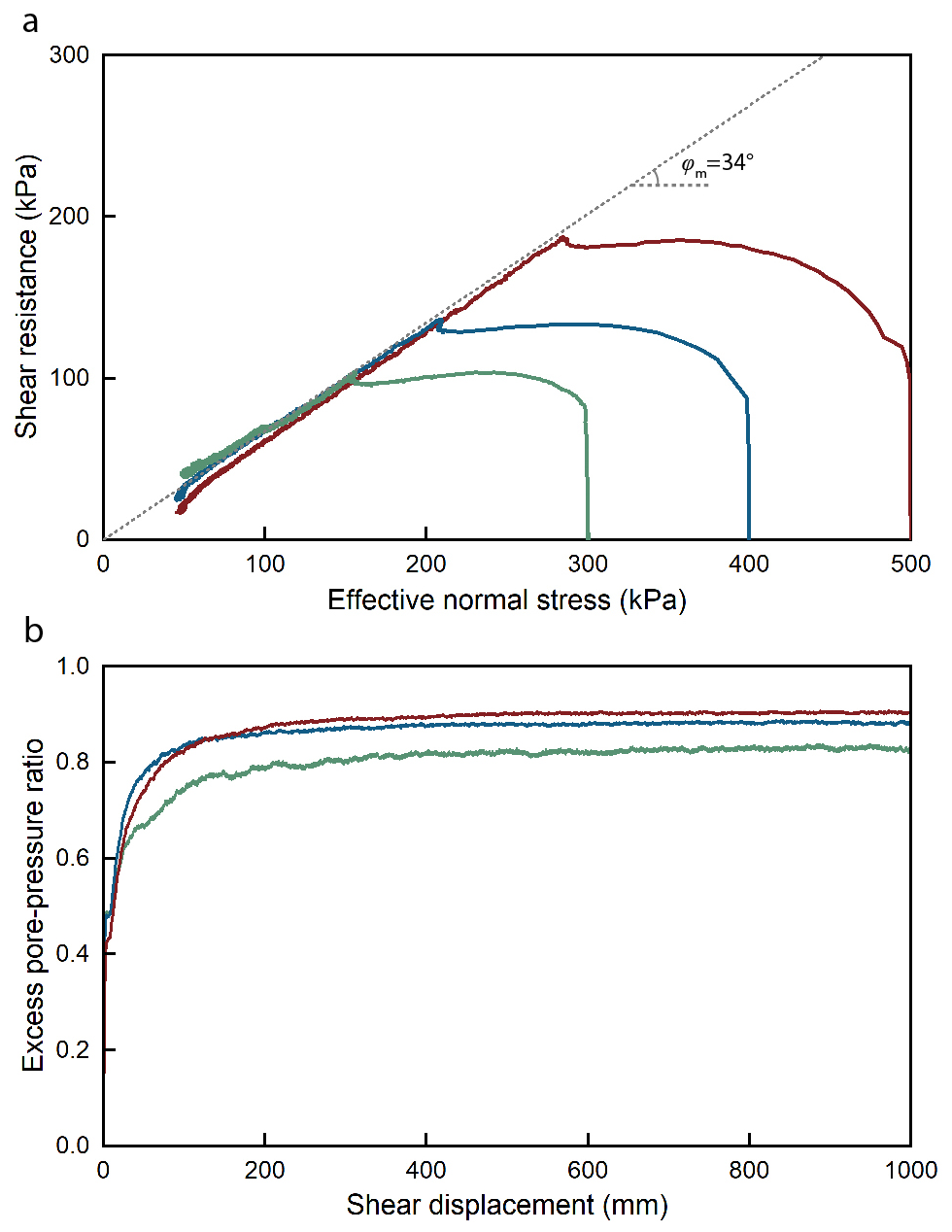
Figure A1Strength properties of the LSB sand determined by monotonic rate-controlled shear tests. (a) Stress paths of undrained monotonic ring-shear tests on saturated specimens and the failure line. (b) Excess pore water pressure ratio in the monotonic shear tests.
The processed data and the raw test data are accessible through the ScienceDB depository at https://doi.org/10.57760/sciencedb.28790 (Chen, 2025). The software for numerical simulation is Anura3D which is open access at https://github.com/Anura3D (last access: 21 October 2026). For further inquiries, please contact the corresponding author.
YC designed and performed the physical and numerical experiments. FW acquired the funding, and together with MV provided supervision and conceptualisation for the study. WL, BZ, and CG assisted in data and sample collection during field investigations. YC prepared the manuscript with contributions from all co-authors.
The contact author has declared that none of the authors has any competing interests.
Publisher's note: Copernicus Publications remains neutral with regard to jurisdictional claims made in the text, published maps, institutional affiliations, or any other geographical representation in this paper. The authors bear the ultimate responsibility for providing appropriate place names. Views expressed in the text are those of the authors and do not necessarily reflect the views of the publisher.
The authors are sincerely grateful to the students from Tongji University, including Hao Ma, Zijin Fu, and Youqian Feng, for their kind support during the field investigation.
This research has been supported by the National Natural Science Foundation of China (grant no. 42230715) and the China Scholarship Council (grant no. 202406260107).
This paper was edited by Mihai Niculita and reviewed by six anonymous referees.
Anura3D MPM Research Community: Scientific Manual version 2022, http://www.anura3d.com (last access: 14 October 2026), 2022. a
Bouchut, F., Fernández-Nieto, E. D., Mangeney, A., and Lagrée, P.-Y.: On new erosion models of Savage–Hutter type for avalanches, Acta Mech., 199, 181–208, https://doi.org/10.1007/s00707-007-0534-9, 2008. a
Chen, Y.: Research Data: Runout Mechanism of Landslides in Alluvial Basins, Science Data Bank [data set], https://doi.org/10.57760/sciencedb.28790, 2025. a
Collins, B. D. and Reid, M. E.: Enhanced landslide mobility by basal liquefaction: The 2014 State Route 530 (Oso), Washington, landslide, GSA Bulletin, 132, 451–476, https://doi.org/10.1130/B35146.1, 2019. a
Crosta, G. B., Imposimato, S., and Roddeman, D.: Granular flows on erodible and non erodible inclines, Granul. Matter, 17, 667–685, https://doi.org/10.1007/s10035-015-0587-8, 2015. a
Cruden, D. M. and Hungr, O.: The debris of the Frank Slide and theories of rockslide–avalanche mobility, Can. J. Earth Sci., 23, 425–432, https://doi.org/10.1139/e86-044, 1986. a
Dai, Z., Wang, F., Cheng, Q., Wang, Y., Yang, H., Lin, Q., Yan, K., Liu, F., and Li, K.: A giant historical landslide on the eastern margin of the Tibetan Plateau, B. Eng. Geol. Environ., 78, 2055–2068, https://doi.org/10.1007/s10064-017-1226-x, 2019. a
Evans, S. G., Guthrie, R. H., Roberts, N. J., and Bishop, N. F.: The disastrous 17 February 2006 rockslide-debris avalanche on Leyte Island, Philippines: a catastrophic landslide in tropical mountain terrain, Nat. Hazards Earth Syst. Sci., 7, 89–101, https://doi.org/10.5194/nhess-7-89-2007, 2007. a, b
Goren, L. and Aharonov, E.: Long runout landslides: The role of frictional heating and hydraulic diffusivity, Geophys. Res. Lett., 34, https://doi.org/10.1029/2006GL028895, 2007. a
Guo, C., Zhang, Y., Montgomery, D. R., Du, Y., Zhang, G., and Wang, S.: How unusual is the long-runout of the earthquake-triggered giant Luanshibao landslide, Tibetan Plateau, China?, Geomorphology, 259, 145–154, https://doi.org/10.1016/j.geomorph.2016.02.013, 2016. a
Guo, C., Zhang, Y., Zhang, Y., Wu, Z., Li, X., Wu, R., Yan, Y., Qiu, Z., Ren, S., and Zhao, W.: Freeze-thaw cycle effects on granite and the formation mechanism of long-runout landslides: insights from the Luanshibao case study in the Tibetan Plateau, China, B. Eng. Geol. Environ., 82, 394, https://doi.org/10.1007/s10064-023-03427-6, 2023. a
Hungr, O.: Runout Analyses of Potential Landslides of South and Third Peaks: Turtle Mountain, Alberta, AER/AGS Special Report, p. 68, ISBN 978-1-4601-0171-1, 2017. a
Iverson, R., George, D., Allstadt, K., Reid, M., Collins, B., Vallance, J., Schilling, S., Godt, J., Cannon, C., Magirl, C., Baum, R., Coe, J., Schulz, W., and Bower, J.: Landslide mobility and hazards: implications of the 2014 Oso disaster, Earth Planet. Sc. Lett., 412, 197–208, https://doi.org/10.1016/j.epsl.2014.12.020, 2015. a
Iverson, R. M. and Ouyang, C.: Entrainment of bed material by Earth‐surface mass flows: Review and reformulation of depth‐integrated theory, Rev. Geophys., 53, 27–58, https://doi.org/10.1002/2013RG000447, 2015. a
Larsen, I. J., Montgomery, D. R., and Korup, O.: Landslide erosion controlled by hillslope material, Nat. Geosci., 3, 247–251, https://doi.org/10.1038/ngeo776, 2010. a
Legros, F.: The mobility of long-runout landslides, Eng. Geol., 63, 301–331, https://doi.org/10.1016/S0013-7952(01)00090-4, 2002. a
Liu, W., He, S., and Li, X.: Numerical simulation of landslide over erodible surface, Geoenvironmental Disasters, 2, 19, https://doi.org/10.1186/s40677-015-0027-4, 2015. a
Mangeney, A.: Landslide boost from entrainment, Nat. Geosci., 4, 77–78, https://doi.org/10.1038/ngeo1077, 2011. a
Mangeney, A., Roche, O., Hungr, O., Mangold, N., Faccanoni, G., and Lucas, A.: Erosion and mobility in granular collapse over sloping beds, J. Geophys. Res.-Earth, 115, https://doi.org/10.1029/2009JF001462, 2010. a
Okura, Y., Kitahara, H., Sammori, T., and Kawanami, A.: The effects of rockfall volume on runout distance, Eng. Geol., 58, 109–124, https://doi.org/10.1016/S0013-7952(00)00049-1, 2000. a
Pudasaini, S. P.: A comprehensive, unified mechanical erosion model for multi-phase mass flows, Int. J. Multiphas. Flow, 191, 105328, https://doi.org/10.1016/j.ijmultiphaseflow.2025.105328, 2025. a
Pudasaini, S. P. and Fischer, J.-T.: A mechanical erosion model for two-phase mass flows, Int. J. Multiphas. Flow, 132, 103416, https://doi.org/10.1016/j.ijmultiphaseflow.2020.103416, 2020. a
Pudasaini, S. P. and Krautblatter, M.: The mechanics of landslide mobility with erosion, Nat. Commun., 12, 6793, https://doi.org/10.1038/s41467-021-26959-5, 2021. a
Pudasaini, S. P., Mergili, M., Lin, Q., and Wang, Y.: Dynamic Simulation of Rock-Avalanche Fragmentation, J. Geophys. Res.-Earth, 129, e2024JF007689, https://doi.org/10.1029/2024JF007689, 2024. a
Reid, M.: 2014 Landslide in Washington State, Office of Communications, U.S. Geological Survey, https://www.usgs.gov/media/images/2014-landslide-washington-state-7 (last access: 14 October 2026), 2017. a
Ren, J., Qi, S., Xu, Z., Kang, W., Su, Q., and Lv, Y.: Timing of the Luanshibao Giant Landslide in eastern Tibet: the evidence from paleoseismology, IOP C Ser. Earth Env., 861, 052002, https://doi.org/10.1088/1755-1315/861/5/052002, 2021. a, b
Sassa, K., Fukuoka, H., Wang, G., and Ishikawa, N.: Undrained dynamic-loading ring-shear apparatus and its application to landslide dynamics, Landslides, 1, 7–19, https://doi.org/10.1007/s10346-003-0004-y, 2004. a, b
Sassa, K., Dang, K., He, B., Takara, K., Inoue, K., and Nagai, O.: A new high-stress undrained ring-shear apparatus and its application to the 1792 Unzen–Mayuyama megaslide in Japan, Landslides, 11, 827–842, https://doi.org/10.1007/s10346-014-0501-1, 2014. a
Shi, X., Jiang, L., Jiang, H., Wang, X., and Xu, J.: Geohazards Analysis of the Litang–Batang Section of Sichuan–Tibet Railway Using SAR Interferometry, IEEE J. Sel. Top. Appl., 14, 11998–12006, https://doi.org/10.1109/JSTARS.2021.3129270, 2021. a
Vicari, H., Tran, Q.-A., Metzsch Juel, M., and Gaume, J.: The role of dilatancy and permeability of erodible wet bed sediments in affecting erosion and runout of a granular flow: Two-phase MPM–CFD simulations, Comput. Geotech., 185, 107307, https://doi.org/10.1016/j.compgeo.2025.107307, 2025. a
Wang, F., Sun, P., Highland, L., and Cheng, Q.: Key factors influencing the mechanism of rapid and long runout landslides triggered by the 2008 Wenchuan earthquake, China, Geoenvironmental Disasters, 1, 1, https://doi.org/10.1186/s40677-014-0001-6, 2014. a
Wang, Y., Cheng, Q., Lin, Q., Li, K., and Yang, H.: Insights into the kinematics and dynamics of the Luanshibao rock avalanche (Tibetan Plateau, China) based on its complex surface landforms, Geomorphology, 317, 170–183, https://doi.org/10.1016/j.geomorph.2018.05.025, 2018. a
Wang, Y., Cui, X., Che, Y., Li, P., Jiang, Y., and Peng, X.: Identification and Analysis of Unstable Slope and Seasonal Frozen Soil Area along the Litang Section of the Sichuan–Tibet Railway, China, Remote Sens., 15, 1317, https://doi.org/10.3390/rs15051317, 2023. a
Wartman, J., Montgomery, D. R., Anderson, S. A., Keaton, J. R., Benoît, J., dela Chapelle, J., and Gilbert, R.: The 22 March 2014 Oso landslide, Washington, USA, Geomorphology, 253, 275–288, https://doi.org/10.1016/j.geomorph.2015.10.022, 2016. a
Wu, Y.-B., Duan, Z., Peng, J.-B., Zhang, Q., and Pähtz, T.: Influence of slope angle on deposit morphology and propagation of laboratory landslides, Sci. Rep., 13, 9452, https://doi.org/10.1038/s41598-023-36554-x, 2023. a
Yerro, A., Soga, K., and Bray, J.: Runout evaluation of Oso landslide with the material point method, Can. Geotech. J., 56, 1304–1317, https://doi.org/10.1139/cgj-2017-0630, 2019. a
Zeng, Q., Yuan, G., Davies, T., Xu, B., Wei, R., Xue, X., and Zhang, L.: 10Be dating and seismic origin of Luanshibao rock avalanche in SE Tibetan Plateau and implications on Litang active fault, Landslides, 17, 1091–1104, https://doi.org/10.1007/s10346-019-01319-z, 2020. a, b, c
Zhang, D., Wang, J., Qi, L., Zhang, Y., Ma, J., and Lu, G.: Initiation and movement of a rock avalanche in the Tibetan Plateau, China: insights from field observations and numerical simulations, Landslides, 19, 2569–2591, https://doi.org/10.1007/s10346-022-01917-4, 2022. a
Zhao, B., Zhao, X., Zeng, L., Wang, S., and Du, Y.: The mechanisms of complex morphological features of a prehistorical landslide on the eastern margin of the Qinghai-Tibetan Plateau, B. Eng. Geol. Environ., 80, 3423–3437, https://doi.org/10.1007/s10064-021-02114-8, 2021. a
Zhao, X., Wang, Y.-s., Wang, S.-y., Zhao, B., Zeng, L., Liu, Y., and Feng, Q.-q.: Nature and timing of a prehistoric giant landslide on the eastern margin of the Tibetan Plateau, J. Mt. Sci., 17, 1438–1451, https://doi.org/10.1007/s11629-019-5831-y, 2020. a
Zhu, L., Cui, S., Pei, X., Zhang, X., Wang, H., He, S., and Luo, L.: Investigation of the characteristics and long-runout movement mechanisms of the Luanshibao landslide on the eastern margin of the Qinghai-Tibet Plateau, Soil Dyn. Earthq. Eng., 153, 107094, https://doi.org/10.1016/j.soildyn.2021.107094, 2022. a
Zhu, L., Tang, X., He, S., Yang, Z., Liang, H., Lei, X., Luo, Y., and Zhang, L.: Geomorphology and Sedimentology of the Nyixoi Chongco Rock Avalanche and Implications for Emplacement Mechanisms, J. Geophys. Res.-Earth, 130, https://doi.org/10.1029/2024JF007666, 2025. a
- Abstract
- Introduction
- Characteristics of the Luanshibao landslide
- Materials and Methods
- Results
- Discussions
- Conclusions
- Appendix A: Strength properties of the LSB sand derived from monotonic shear tests
- Code and data availability
- Author contributions
- Competing interests
- Disclaimer
- Acknowledgements
- Financial support
- Review statement
- References