the Creative Commons Attribution 4.0 License.
the Creative Commons Attribution 4.0 License.
 | 14 Apr 2026
A geospatial database of coastal characteristics for erosion assessment of Europe's coastal floodplains
Robert J. Nicholls
Floris R. Calkoen
Gonéri Le Cozannet
Arjen P. Luijendijk
Coastal erosion and flooding are linked, with erosion potentially exacerbating flood extents and risk, but analysis of the combined hazards is limited. This paper describes the CoasTER geographic database specifically designed for the first time to integrate existing information on erosion and other relevant characteristics for Europe's coastal floodplains. The CoasTER database updates and builds on earlier erosion research and data sources. At the European scale, it combines fundamental erosion-relevant information (sediment type, land use, floodplains, geomorphology, historical shoreline movement trend) on a standard shoreline to highlight the potential magnitude of erosion-flood interactions by defining where mobile sediments and coastal floodplains are co-located. It also identifies where morphodynamic response to sea-level rise is constrained due to structures/infrastructure.
Results indicate almost 80 % (25 000 km) of the total shoreline length associated with European coastal floodplains (approx. 31 000 km) are composed of mobile sediments, with coastal wetlands being the most prevalent geomorphological type. While accretion is the dominant historical trend for these shorelines, approximately 27 % are currently classed as eroding at over 0.5 m yr−1 over the last 40 years. The majority of floodplain shorelines are associated with either developed or agricultural areas and constraining human structures that occur along almost 8000 km of shoreline. The CoasTER database demonstrates that episodic and/or long-term erosion and coastal flooding is a Europe-wide issue that deserves the attention of local to European decision-makers in order to define a coherent management strategy.
- Article
(5832 KB) - Full-text XML
- BibTeX
- EndNote


It is well known that the hazards of coastal erosion and flooding are strongly linked (e.g., Grases et al., 2020; Leaman et al., 2021; Pollard, 2019; Toimil et al., 2023). Figure 1, for example, illustrates how erosion and the removal of sediments during a major storm can create new flood pathways and exacerbate flooding among other effects. However, quantitative analysis of these two hazards and coastal structures is uncommon due to the complexity of these processes, especially at broad spatial scales (e.g., Pollard et al., 2019). With growing interest in climate services to support adaptation (Le Cozannet et al., 2017; McInnes et al., 2024) this deficiency is an important issue to address. The Coastal Climate Services (CoCliCo) project is developing tools to plan and manage response to sea-level rise and climate change concerning coastal flooding around Europe. This includes mapping of the extent of coastal flooding both today and projecting it to 2100 under climate scenarios.
Figure 1Aerial photograph (28 February 2010) illustrating how the erosion of Belle Henriette (right) created an additional pathway for floodwaters (blue arrow) into La Faute-sur-Mer, France during Storm Xynthia 2010 (Photo J.-P. Bichon, interpretation M. Garcin, BRGM; see also Pedreros et al., 2010, Gerard and Lang, 2019).
However, existing coastal erosion databases of Europe are limited. There are European assessments of coastal erosion as an issue (e.g., Pranzini and Williams, 2013), as well as national databases (e.g., England – EA, 2025). Some global databases and analyses (Hinkel et al., 2013; Mentaschi et al., 2018; Luijendijk et al., 2018; Vousdoukas et al., 2020) also include Europe. However, the only European databases are Eurosion (2004) and its predecessor CORINE Coastal Erosion published in 1998 through the European Environmental Agency (Quelennec et al., 1998).
To support the CoCliCo effort in terms of a better understanding of flood-erosion interactions, this paper therefore presents the “Coastal Typologies and Erosion for Risk database”, henceforth abbreviated to the “CoasTER database”. The database builds on the earlier Europe-wide erosion study (Eurosion, 2004) and combines it with additional relevant coastal characteristics concerning coastal flooding to provide a first specifically designed exploratory assessment tool for the majority of Europe. The underlying data are freely available from multiple sources. The database has been standardised on an updated shoreline (EEA, 2017) to ensure ease of use, compatibility and longevity. It provides a step towards inclusion of erosion within broadscale climate services for Europe and its simple structure allows new or additional content to be incorporated. This paper describes how the database was conceptualised, the data sources and presents some initial analysis as well as discussions of the limitations and possible improvements.
Coastal geomorphology reflects geological inheritance and the production, storage and movement of sediments in response to natural and human influences (Woodroffe, 2002). The resultant processes of erosion, transport and deposition produce both desirable coastal landforms such as beaches but also result in erosion and flood hazards which affect people and their assets. These are longstanding issues around coasts worldwide with far-reaching implications for coastal communities, ecosystems, and economies (e.g., Pranzini et al., 2015; van de Wal et al., 2023). As coastal areas continue to develop both in demographic and economic terms, and the consequences of long-term coastal dynamics and climate change, especially sea-level rise, become more apparent, understanding and managing erosion and its link with flooding is essential (e.g., Georgic and Klaiber, 2022).
Coastal erosion is often regarded as a permanent loss of coastal land, due to loss of material with direct or indirect impacts for both developed areas and the natural environment. While this is the case for some coastal features such as cliffs, for low-lying areas it can be part of an oscillating cycle of accretion and erosion (e.g., Bateman et al., 2020; Kennedy et al., 2019; Pollard et al., 2019; Stive et al., 2002). Analysis at multiple scales can provide a context for these differences, identifying relevant spatial patterns helping in the formulation of policies and funding allocation that are tailored to specific needs, and coordinated across administrative boundaries, leading to more effective and targeted interventions (Le Cozannet et al., 2025). It can also highlight where more detailed or localised analysis may be needed. Providing a classification-based spatial database at this scale will therefore help in organizing information and allow users to identify such areas. Classification of distinct types of coast and their characteristics is recognised as a practical evidence-based tool for coastal analysis (e.g., Athanasiou et al., 2024; Finkl, 2004; Morales, 2022; Wolff et al., 2018; Zuo et al., 2025).
To our knowledge, the first attempt to assess coastal erosion at broad scales was undertaken under the auspices of the International Geographical Union in the 1970s and 1980s (Bird, 1985). This analysis comprised a bottom-up collection of observations around the world but did not cover all coastlines in detail. A key result emerged from this study: it was estimated that 70 % of coastal beaches were eroding worldwide. In Europe, an analysis of erosion has previously been undertaken based on coastal geomorphology and sediment types (Eurosion, 2004). Combining this data with other key aspects relevant to the possibility of erosion occurrence on an updated shoreline creates a more meaningful dataset for exploring the relationship between erosion and flooding and forms the basis of the CoasTER database (Fig. 2).
Figure 2Flow diagram describing the conceptual process behind the development of the CoasTER database.
Table 1Open source data/information included in the CoasTER database and used in the generation of a coastal geomorphic typology.
The underlying information is open source (Table 1). Inclusion of the presence of coastal defences and infrastructure adjacent to the shoreline (structures/infrastructure), as well as land cover type, captures the historical context and the current ability of the coastal system to respond to changing water levels. This information allows for the development of a generic, qualitative geomorphologically-based coastal typology built around the premises that: (1) in response to sea-level rise, the coastal geomorphological profile will tend to migrate landward over the long-term (e.g., Hanson et al., 2010; Masselink et al., 2020; Mentaschi et al., 2018; Oppenheimer et al., 2019; Wen et al., 2023); and (2) any coastal infrastructure, particularly hard defences, will constrain the evolution of the coastal profile and may become increasingly exposed to coastal processes and forces over time (Enwright et al., 2016; van Rijn, 2011).
Combining this data within a GIS environment, in addition to identifying flood/erosion interactions, allows for other spatial analyses such as sediment distribution. Section 3 further explains the development of the coastal typology and the datasets that are used to populate the CoasTER database.
Coastal environments are characterised by various key factors including sediment supply, beach materials, underlying geology and human activity, which all influence the dynamic nature of the coastal zone. The CoasTER database collates information for a broad-scale flood and erosion analysis of the European coast considering the distribution and evolution of mobile geomorphological features and their attributes.
3.1 Reference shoreline
The utility of the existing erosion dataset is initially increased by mapping the data onto a shoreline that is more representative and potentially usable within other GIS-based coastal analyses. The shoreline dataset selected for the analysis is that provided by the European Environment Agency and is derived from satellite imagery (EEA, 2017). The shoreline is composed of a series of segments that have an average length of approx. 100 m with a maximum of 4 km length. After decomposing these within a QGIS environment into individual line segments, these form the basis for the CoasTER database (see Fig. 3b). After removal of extraneous artifacts and duplicate sections, the coastline covers nearly 128 500 km of shoreline of which 81 000 km is covered by data within the CoasTER database (see Fig. 3a). This covered the majority (73 %) of shoreline for 18 EU countries plus the United Kingdom (UK) and Monaco. Non- and new (post 2005) EU countries, estuaries and inlets, some complex coasts and most small islands (typically less than 1 km2) were omitted due to lack of information in underlying source data. Flood and erosion-related attributes (characteristics) are appended using spatial joins. Importantly, coastal characteristics were attributed considering a coastal zone extending approximately 100 m landward of the EEA shoreline (coastal erosion zone). This indicative erosion zone (Fig. 3b), is based on the typical maximum cross-shore scale of erosion expected by 2100. Note that erosion could locally exceed this indicative distance in some locations. It allows consideration of potential erosion over this century and identifies what coastal assets may be exposed over time (e.g., see Marine Scotland, 2020).
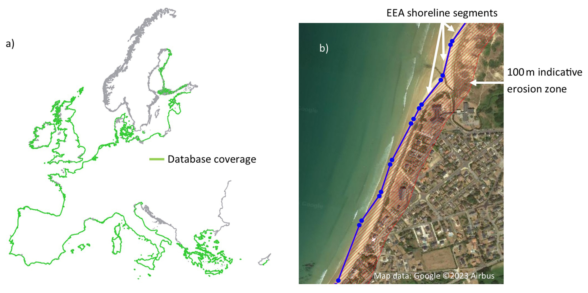
Figure 3The EEA shoreline showing the database coverage (a) and example of coastal segments with indicative erosion zone (b).
3.2 Key coastal characteristics
The sources for the coastal characteristics and reclassification included in the database shown in Table 1 are listed in Appendix Tables A1 and A2, with the derived attributes listed in Appendix Table B1. These characteristics, combined with a coastal geomorphic typology, provide a baseline for assessing the tendency for erosion along the shoreline and where this coincides with the potential for flooding.
3.2.1 Sediment type
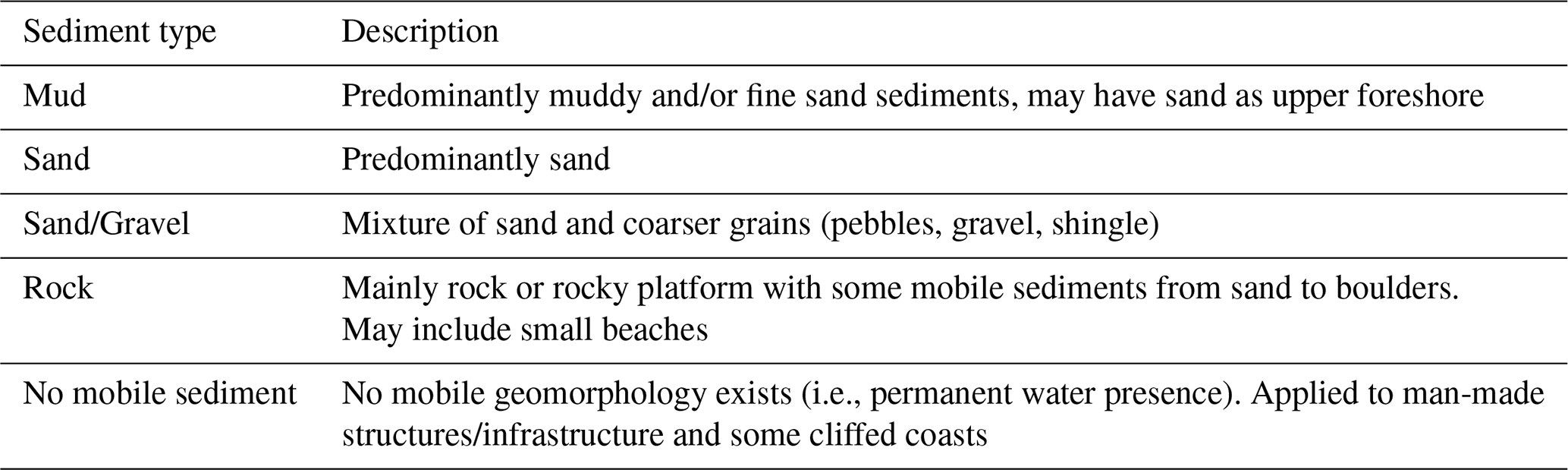
Coastal sediment type is an important characteristic indicative of coastal change and erosion; rocky coasts and foreshores tend to have different erosional dynamics than sandy coasts for example. Each coastal segment therefore has simplified sediment information based on the Eurosion dataset (see Table A1 and Eurosion, 2003) validated by visual interpretation. Four sediment types were defined (Table 2) and applied according to the sediment present at the shoreline. An additional fifth class of “no mobile sediment” was needed to describe segments where no mobile geomorphology was present, mostly found associated with ports and harbours (human infrastructure) and some erosion-resistant coasts. Where two sediment types are present (e.g., a sandy beach at the edge of a muddy estuary), this was also recorded.
Table 2Description of coastal sediment types recorded in the CoasTER database.
3.2.2 Land cover
As the potential impact of erosion or landward migration is mainly determined by the value and use of any land affected, the Corine 2018 land cover dataset (CLC, 2020) was utilised. Corine 2018 identifies 43 land cover categories which were re-grouped and simplified into 7 classes to represent developed, agricultural and natural areas (see Table A2 for details). Each segment was allocated the simplified code according to the land cover within the 100 m coastal zone. The positional accuracy of this data set is 100 m or better with a spatial resolution of 25 ha/100 m (CLC, 2020), and was amended, if necessary, based on visual interpretation of satellite imagery.
3.2.3 Coastal structures/infrastructure
Coastal segments that are associated with visible human engineered structures, both onshore and offshore, are identified. In this analysis, all structures/infrastructure are considered as potential constraints on geomorphic response (i.e., constrained in Table 3). This extends beyond coastal defences to include infrastructure such as roads and railways as well as buildings that are within the 100 m coastal erosion zone. While this infrastructure may not be defences, they are likely to perform a similar role in constraining the natural evolution of the coastal system either directly or indirectly by triggering a defence response. This allows for the consideration of infrastructure that may, over time and on an erosive coast, require coastal defences to prevent their damage or loss. The presence of coastal structures/infrastructure is taken from the incorporated datasets supplemented with new or extended lengths following application of the criteria and verified by visual inspection using World Imagery (Esri, 2024) and Google Earth (Google Earth, 2024).
Ports and harbours are considered onshore infrastructure but are also identified separately as they can generally be regarded as fixed sections of the shoreline with no geomorphic component of the response. Offshore structures are also recorded separately and are considered to limit rather than constrain geomorphological response unless found in conjunction with onshore structures/infrastructure, where the latter are considered to have the dominant influence. Corine 2018 codes were also combined with coastal structure information to differentiate between major ports and minor ports and harbours. Where harbour segments in the database and the Corine 2018 port code coincide, a major port was identified. Ports and harbours associated with other land cover types are then considered to be either minor ports or recreational harbours.
3.2.4 Coastal floodplain extents
Each coastal segment is connected, where appropriate, to a coastal floodplain defined by the 1-in-100 year extreme water level from COAST-RP (Dullaart et al., 2021) and includes an allowance for sea-level rise, generated within the CoCliCo project (Lincke and Hinkel, 2023). These extended floodplains use a 2 m rise in sea level assuming no human intervention in line with recent guidance (e.g., Le Cozannet et al., 2023), which argues that 2 m of sea-level rise is inevitable over the coming centuries and should be considered in planning strategies. The floodplains are generated using the Copernicus European Digital Elevation Model (EU-DEM, 2016, approx. resolution 30 m) and converted from raster to vector format for integration in the database. To be included as a floodplain, the minimum area below the defined water elevation is 0.02 km2. Narrow linear floodplains along otherwise rocky and cliffed coasts are therefore included in addition to large coastal plains.
The defined floodplains are hydrologically linked to the open coast and, where they directly coincide, a local floodplain identification number is assigned to the coastal segment. However, erosion of barrier coast features such as barrier islands and spits can also have implications over larger distances/areas and for floodplains not directly adjacent to the shoreline (e.g., Bateman et al., 2020; Scott et al., 2020; Stéphan et al., 2024). To capture these potential effects, protective barrier features are also linked to these “remote” landward floodplains using floodplain identification numbers. Shorelines not connected to any of the defined floodplains are considered non-floodable for the purposes of this analysis.
3.2.5 Historical shoreline movement
Although the general premise is that the coastal profile will migrate landward over the long-term with rising water levels, short-term profile fluctuations are expected to occur as a result of variations in waves, tides, storms and sediment availability and movement, particularly for low-lying geomorphologies. While the Eurosion database includes information about observed shoreline changes over the 1980s and the 1990s, this was obtained by a bottom-up approach whereby local, regional and national observatories reported about their local observations (Le Cozannet et al., 2020). This data was not included here as: (1) the observation timeframe is shorter than those based on remote sensing data currently available, and (2) the reporting process was prone to sporadic errors due to variable and inconsistent interpretation of the Eurosion collection methodology (Le Cozannet et al., 2016).
A dataset of historical spatially-consistent shoreline movement based on Landsat satellite measurements covering the period 1984 to 2021 (37 years; accuracy subpixel or < 15 m on Landsat data) was therefore used to consistently describe long-term shoreline movement trends. This is an extension to the data analysed in Luijendijk et al. (2018) and, based on the accuracy of satellite-derived shorelines (e.g., Hagenaars et al., 2018), was used to identify three movement trends: (1) moving landward (erosion or migration < −0.5 m yr−1), (2) moving seaward (accretion > 0.5 m yr−1) and (3) remaining in the same position (stable −0.5 to 0.5 m yr−1). These broad classes distinguish rapidly changing shorelines (erosion or accretion) from slower-changing or stable coasts. The CoasTER database therefore focuses on where movement trends are most evident rather than providing precise localised rates. Importantly, these thresholds may be too imprecise to meet the needs of coastal adaptation managers, especially in areas where coastal assets are located close to the shorelines and lower erosion rates (e.g. 10 to 20 cm yr−1) are observed.
Not all segments in the reference shoreline have historical movement data as the dataset focusses on the open mainland coast; small islands (e.g., along the coast of Finland), shorelines behind major infrastructure (e.g., the Netherlands), inland extents of some rivers and inlets (e.g., Lisbon) are not covered in their entirety. In addition, the effects of soft management (e.g., beach nourishment, managed realignment or saltmarsh restoration), which can modify any underlying natural trend and is recently being practised on larger scales (Brand et al., 2022; de Schipper et al., 2021; Foster et al., 2013; Hanson et al., 2002; Hudson et al., 2021) are not identified in the CoasTER database as there is no European dataset and it is not always possible to distinguish these details at the regional scale.
3.3 Coastal geomorphologically based typology
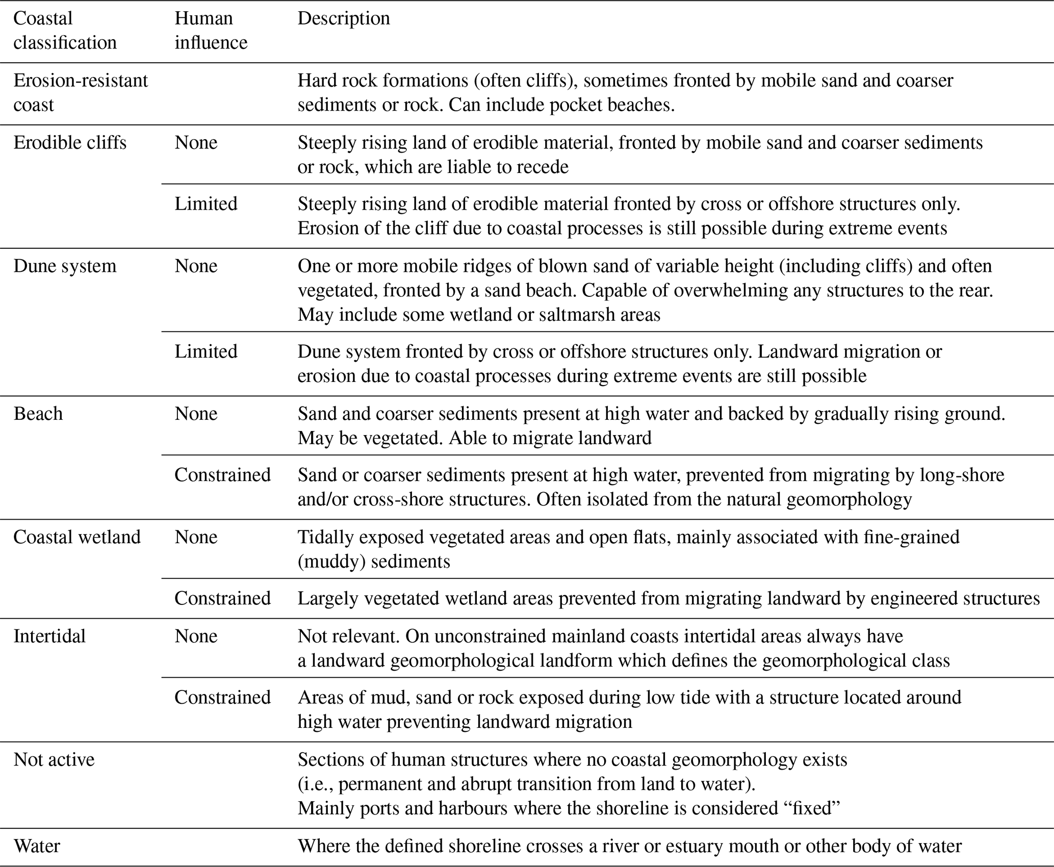
Building on the coastal characteristics, as a first step, a distinction between erodible and erosion-resistant coast largely based on the Eurosion classification codes (Eurosion, 2004; see Table A1) was developed. Erosion-resistant coastal segments follow the Eurosion codes A and C, described as mainly “rocks and/or cliffs made of hard rocks (little subject to erosion)” or “mainly rocky, little erodible, with pocket beaches (< 200 m long)”, respectively. The remaining segments were then considered to be erodible and, as a second step, were classified according to a four-class geomorphological typology based on coastal landforms. This typology identifies the dominant mobile geomorphological landform on the natural cross-shore profile, effectively (erodible) cliffs, dunes, beaches and wetlands.
As a third step, where an engineered structure restricts the ability of the coastal profile to migrate landward (or erode), the geomorphological class is redefined to include just the landforms that are still responsive to coastal processes (i.e. seaward of the structure). Structures/infrastructure may constrain or limit coasts as follows: (1) constrained coasts where a shore parallel structure forms a continuous fixed boundary which prevents potential landward movement, for example, a seawall or promenade; and (2) limited coasts where structures may reduce but not prevent landward migration, especially during extreme events, for example, an offshore breakwater. Where coastal structures/infrastructure define the shoreline and there is no natural coastal geomorphological landform (most commonly found at ports and harbours), the shoreline is considered to be geomorphically “not active” (Table 3).
Table 3Coastal classification with description, including consideration of the effect of structures/infrastructure on the ability of geomorphological landforms to migrate and/or erode.
The results presented here illustrate the CoasTER database and focus on insights concerning flood and erosion interactions by selecting from the database all the segments associated with an extended coastal floodplain. Over 31 000 km (nearly 40 %) of the analysed shoreline have the potential to be flooded when considering the influence of 2 m sea-level rise on water levels. Nineteen of the countries included (Monaco being the exception) have coastal floodplains which range from nationally significant, for example, the Netherlands where 95 % of the shoreline is associated with large coastal floodplains (see Fig. 4) to countries where the associated coastal lengths are long, but floodplains cover a relatively small proportion of a country's total area. The latter indicate either the presence of locally significant coastal floodplains (e.g., Portugal, Italy, Poland) or where the floodplains have limited inland extent but are continuous along the shoreline (e.g., Finland, Estonia).
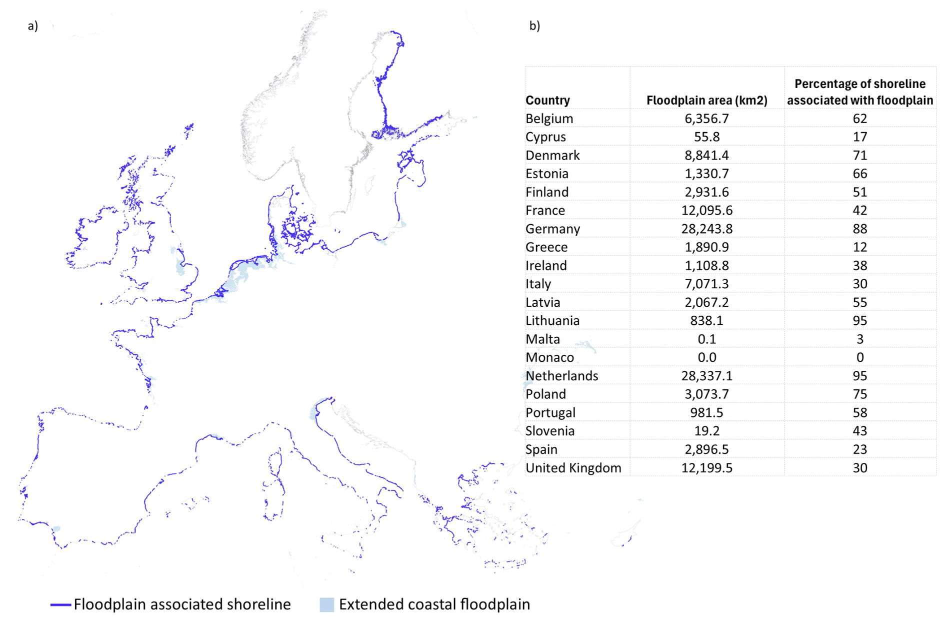
Figure 4Coastal lengths associated with the extended coastal floodplains (a) and significance for individual countries (b).
Fourteen percent (4400 km) of the analysed shoreline was identified to be acting as barriers (e.g., spits, barrier islands) influencing potential flood events, with Germany, Denmark and the UK having the longest length of shoreline so classified. In addition to having local coastal floodplains (directly affected by changes in water levels), the evolution of these features can affect flooding over larger areas. Just over 2000 km of barrier shorelines were found to be associated with this more extensive flooding potential (remote coastal floodplains). Lithuania and Poland have the highest percentage of their shoreline (69 % and 51 %, respectively) identified with this large-scale flooding potential if barrier erosion occurs. However, the historical movement trends, where available, indicate that the majority of these shorelines are currently stable or accreting (66 %).
Eroding barrier segments, commonly sandy dune systems, are concentrated in northern Europe along the Dutch and German coasts, although localised eroding examples are also found along the Mediterranean coasts. For local floodplains, although there are some low-lying floodable areas that are considered erosion-resistant due to their rock sediment type (e.g., Greece, the UK, Finland and Ireland), the majority (approx. 25 000 km, 80 %) of the extended floodplain shoreline is associated with mobile sediments, almost equal lengths of sand, sand/gravel and fine sediments, and could potentially be subject to erosion. For these erodible coasts, 73 % have historical movement trends that include the effects of any coastal management over the past 37 years. In total across all floodplains with shoreline movement data, accretion is the most common trend (46 %) with erosion and stability found equally along the remaining shoreline (see Fig. 5). However, erosion, which is most prevalent for sandy shorelines, has more impact for individual countries. France, Belgium and Portugal, for example, have a high prevalence of erosion along their floodable shorelines. This could have implications for Portugal in particular, where the longest erosive lengths are also associated with natural barriers.
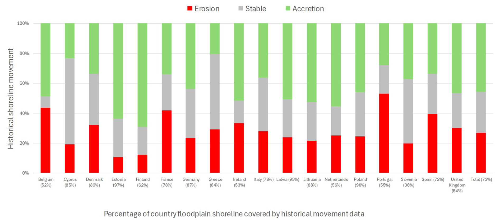
Figure 5Percentage of erodible coastal floodplain shorelines in the database by country and total with historical movement trends, irrespective of human activity and coastal type. Excludes erosion-resistant shorelines, ports and harbours and shorelines with no data.
The current coastal geomorphology along the floodplain shoreline is most frequently natural (undeveloped and without structures/infrastructure) coastal wetlands and dune systems which are associated with extensive local floodplains (Fig. 6). For these shorelines, landward movement (represented as erosion) is found along around 3500 km (34 %) of floodable shoreline and is part of the natural (unrestricted) evolution of the coastal system. The majority of these combined geomorphological classes are associated with open scrubland with less than 125 km (< 4 %) of the eroding shoreline associated with developed areas and 540 km (< 16 %) with agricultural land.
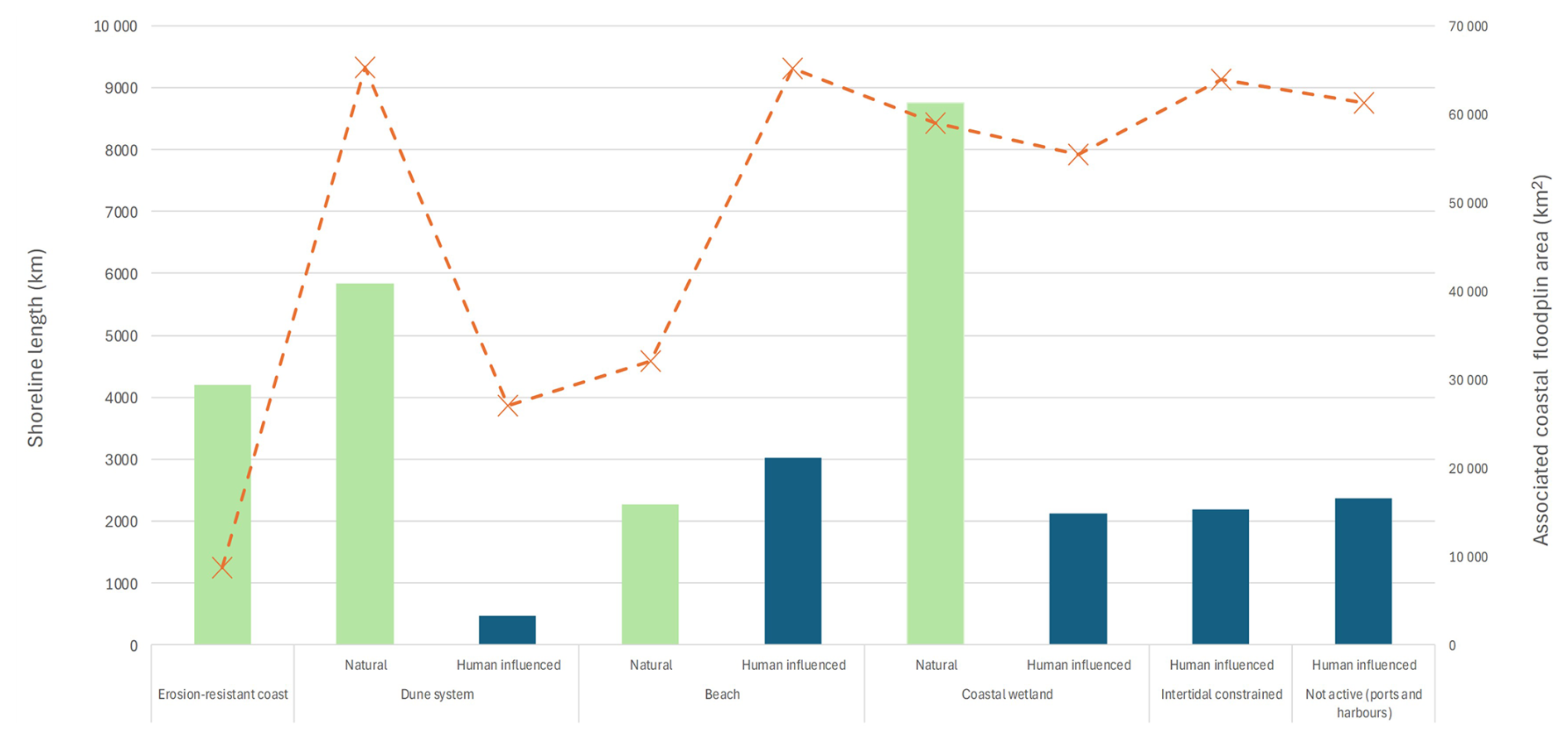
Figure 6Distribution by length (km) of coastal classification with associated local floodplain areas.
Human activity, in the form of engineering within 100 m of the shoreline, extends over approximately 10 000 km (33 %) of shoreline and is related to almost 211 500 km2 of coastal floodplain, a significantly larger area than natural areas. As the effect these structures on the natural coastal geomorphology is to reduce the active coastal system to either a beach or wetland that cannot migrate landward (“constrained” classes; see Table 4 for distribution across countries), these would be expected to decline in width (erode) exposing any landward structures/infrastructure to enhanced wave activity under the influence of sea-level rise (e.g., Pontee, 2013). Where the coastal classification is “intertidal constrained” or “fixed” (ports and harbours), tidal and wave processes are already directly affecting the associated structure/infrastructure and the likelihood of increasing overtopping due to sea-level rise is high (Almar et al., 2021).
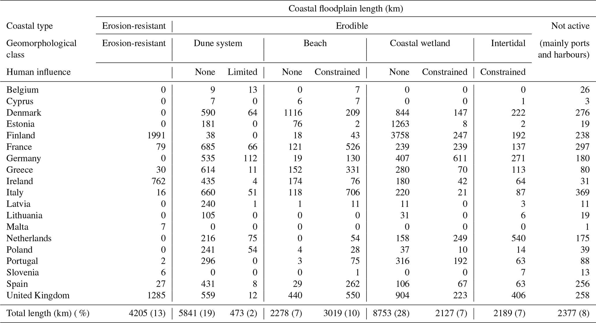
Table 4Coastal length (km) associated with floodplains by coastal typology and country (see Table 3 for details about the various classes).
While the percentage of developed coasts geomorphologically constrained by human structures/infrastructure in floodplains is high (commonly “beach constrained”), the presence constrained geomorphology for other land cover classes is also significant (Fig. 7). Distribution of the “coastal wetland constrained” class which is often associated with agricultural land cover, for example, reflects the social and economic importance (e.g., food security) placed on these areas (e.g., Linnér and Messing, 2012). Structures in these cases are generally erosion and/or flood defence structures. For these constrained shorelines, historical shoreline movement over the past 37 years indicates that erosion has occurred along 1800 km (14 %) across all land cover types. Where classified as wetland areas (almost 500 km, 4 %), it suggests that these defences are often removing accommodation space and impacting coastal wetland extents (e.g., Schuerch et al., 2018). The remaining nearly 5000 km of erodible constrained shorelines have either remained stable or accreted.
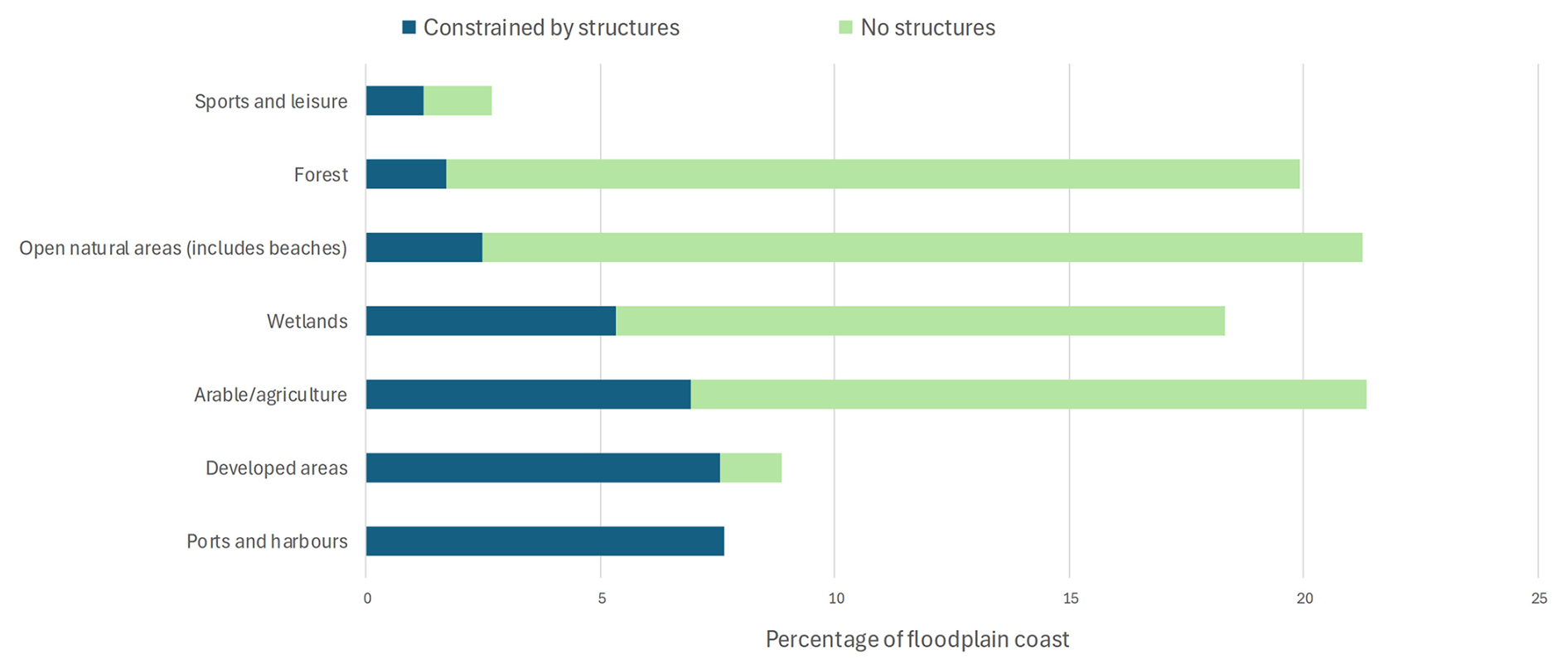
Figure 7Percentage of floodplain coast that is constrained by structures or has no structures, identified by land cover types.
Human structures/infrastructure are identified as either onshore or offshore hard engineering or harbours. The latter representing almost a quarter of the onshore hard engineering by coastal length (see Table 5). As with the length of shoreline associated with the extended floodplains, countries with significant lengths of engineered shoreline are located in northern Europe (Germany, UK, Netherlands). Italy is an exception with extensive development, ports and defence structures along its mainly open shoreline. Italy also has the most notable length of shoreline with both onshore and offshore structures, particularly along its Adriatic coast.
Table 5Length of human structures by country and structure type.
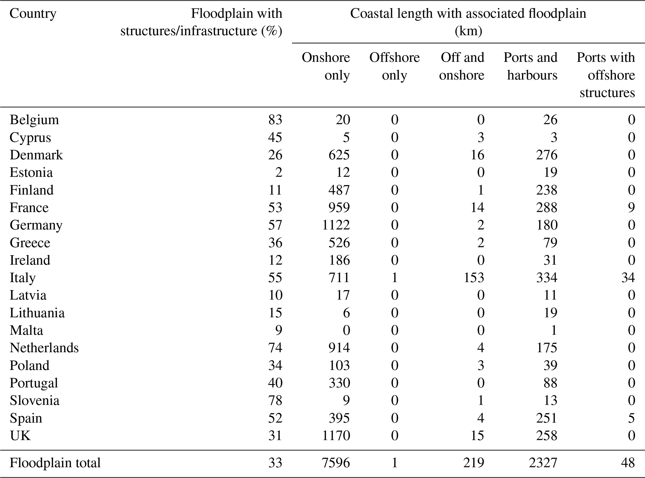
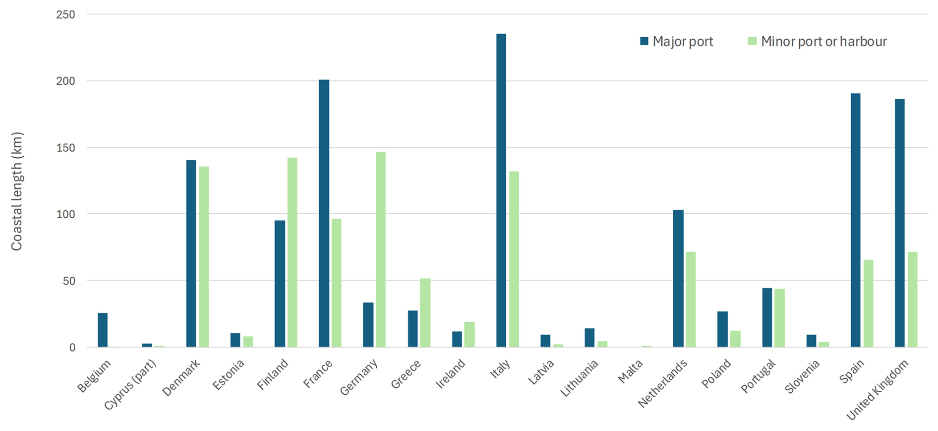
As engineered structures, ports and harbours represent fixed sections along the coast with the necessary infrastructure exposed directly to changing water levels and requiring continual maintenance and upgrade. Major port infrastructure in particular is unlikely to be abandoned even if the port itself is relocated (e.g., Andrade et al., 2024). Figure 8 shows that Italy has the longest length of open coast designated as major port infrastructure in floodplains followed by France, Spain and the UK. Germany, Denmark and Finland, with their large number of islands, have long extents of secondary ports and other harbours. It should be noted that some large ports are not included in the database as a geomorphological landform exists seaward (e.g., the land reclamation – Maasvlakte-2 – seaward of the Port of Rotterdam is fronted by an artificial beach) and some ports may be over represented by length due to the form of the shoreline.
In summary, while erosion occurs over significant lengths of shoreline subject to coastal flooding, it is not the dominant historical shoreline tendency for developed areas where buildings and other infrastructure restrict natural evolution. However, it is important to remember that even where the historical movement trend is stable or accretion, this may not continue into the future as erosion related to rising sea levels is anticipated (Pang et al., 2023). Excluding ports and harbours which are assumed to be maintained and/or adapted in place, if all currently developed coasts experience erosion, over 2500 km will require some degree of coastal management. Similarly, with sea-level rise, over 5000 km of other land cover classes could also experience land loss, particularly important for barrier features. The decision on whether to protect these areas or not will depend on the legislative circumstances, the available funds and social value assigned to agricultural areas and the environment among other issues. For lengths of floodplain coast classified as erosion-resistant, protective structures may still be required but focussed on reducing flood risk rather than preventing erosion.
As coastal areas in Europe are expected to be at a higher risk of flooding and erosion over the coming century due primarily to climate-induced sea-level rise, the CoasTER database offers a new overview of erosion-flood hazard distributions and interactions. The analysis presented here indicates that erosion and flood hazards presently interact over approximately a third of the analysed shoreline, based on 37 years of shoreline movement data. This has not only local implications but could also have consequences for developed areas by affecting the evolution of natural protective barrier features. At the same time, human structures/infrastructure along the shoreline provide a constraint on the coastal system by curtailing its ability to respond to changing coastal water levels by migrating landward, or alternatively necessitating retreat and loss or relocation of the infrastructure. Largely associated with developed and agricultural areas, these constrained shorelines are found along over a third of the floodplain coastline and are related to extensive floodplain areas. There is no direct relationship of these shorelines with historical erosion as two thirds are found to either be stable or accreting. This may be due to natural shoreline variations, the presence of effective defence structures or management using “soft” engineering such as beach nourishment masking the underlying trend as, for example, in the Netherlands.
Also, compared to the previous CORINE Coastal Erosion and Eurosion databases, the CoasTER database uses remote sensing as a source of shoreline change observation. Today, these methods are able to monitor shoreline change rates above a threshold of 0.5 m yr−1, above the requirements of many users who commonly work, locally, with rates in the order of 0.1 or 0.2 m yr−1 (e.g., Castelle et al., 2018). These slower erosion rates can also cause significant risks over time so erosive shoreline lengths reported here may therefore be underestimated. Hence, it would be useful to add or update the historical shoreline movement e.g. through a bottom-up process involving coastal observatories as in Eurosion, when suitable data or local knowledge become available or satellite-derived errors are reduced (e.g., Vos et al., 2023). However, based on an assumption of erosion as a future response to sea-level rise over this century, significant lengths of urban and other developed shorelines are likely to need new or enhanced management action to maintain current levels of risk.
The harmonisation of data within the CoasTER database also makes it easier to understand and explore relationships and interactions between various aspects of the coastal system and identify trends which may otherwise be overlooked. These can highlight areas where particular issues arise. The regional scale of the database offers a general assessment of flood and erosion issues encountered around Europe and provides an estimate of the length of coast that will require active management to protect valuable assets in the future. In particular, the combination of the geomorphological classification to capture the historical context of human activity in the coastal zone, use of an allowance for sea-level rise which captures uncertainty and historical shoreline movement, provides a first assessment at the regional scale for insights into flood and erosion interactions as well as the existing commitment to coastal defence. The classification also illustrates the length of coast which is already “fixed” or constantly exposed to water levels and unlikely to be abandoned. This is currently focussed on ports and harbours but could also cover coasts where any structure is at or near hightide (currently “intertidal constrained”). Also, although generalised results are presented here, the use of coastal segments within the shoreline does offer the opportunity for more detailed analysis. This is particularly the case for historical movement as floodplain evolution is more locally defined and varies both within and between floodplains.
Compiling this database required significant manual effort, often due to inconsistencies in the underlying data sources, which had to be simplified, mapped, and amended where necessary. While it is a valuable geospatial resource for European-scale and regional coastal analysis, it has limitations. The EEA shoreline data offers a detailed and representative shoreline for analysis, but some features, especially reclaimed land, harbours, and other infrastructure contain digitizing artifacts that do not reproduce their general shape. Geomorphically inactive shoreline, mainly ports and harbours, may also appear over represented as a percentage of a country's coast (notably in Belgium, Netherlands); the detailed inclusion of quays, wharves and other infrastructure within the shoreline creating a disproportionate long shoreline length, reflecting the fractal nature of shorelines. There is a similar effect for coastal wetlands (e.g., Portugal) where the detailed shoreline significantly increases lengths and percentages for this geomorphological class. In addition, the shoreline sometimes follows features which are misinterpreted (e.g., following inland cliff lines) or are not visible in satellite imagery (e.g., obscured by vegetation) leading to some subjective inferences being made on the form and composition of the coast. The EEA shoreline also excludes some new developments, e.g., the Port of Rotterdam expansion. Not all of these have been identified and manually corrected. Limitations of coastal characteristic data also need to be recognised. The definition and purpose of the other source data mean that sections of the EEA shoreline do not have information. Some regions, such as Norway and the Adriatic Sea, lack coverage in key source datasets, making it difficult to extend the database to those areas. Full coverage of estuaries, inlets and lagoons is also notably missing as is the majority of Cyprus' shoreline. The Netherlands for example has sections of shoreline behind artificial coastal barriers which are not covered by the historical movement data and the “inland” coasts of North Jutland, Denmark are not covered by sediment and geomorphological information. Transference of attribute data from different shorelines also required the use of assumptions which may have led to inaccuracies and inconsistencies. For example, complex coastlines such as those found in Finland, Ireland and the UK present challenges for the accurate allocation of data, and coverage in the Corine data set does not always correspond with the shoreline.
The inclusion of additional datasets could address some of these issues; for example more detailed geomorphological information (e.g., regional data EMODnet, https://emodnet.ec.europa.eu/en, last access: 16 May 2025; national data e.g., BGS, 2023), coastal water level data (e.g., LISCOAST, Vousdoukas et al., 2020), or more innovative earth observation datasets such as characterising muddy coasts (Hulskamp et al., 2023) could enrich the analysis. Also, the current availability of satellite data, powerful (cloud-) computeing infrastructures and machine learning methods (e.g., Calkoen et al., 2025) can enable automated approaches to coastal classification that can update and improve the dataset presented here. Satellite-derived data products offer consistent, global coverage, while machine learning techniques can be trained to extract coastal characteristics using a consistent method. When combined with modern (cloud-) computing infrastructures, such approaches make it possible to conduct high-resolution, broad-scale coastal analysis with far less manual work. The methodology applied here aligns with this direction, demonstrating the potential for future geospatial data products that leverage satellite data, cloud infrastructure and machine learning.
Despite the limitations identified here, the CoasTER database provides an updated European-scale database that lends itself to development and improvement and is instrumental in allowing investigation of areas of interest for both flooding and erosion, particularly in areas where erosion may ultimately result in increased flood risks. Notably, out of the 31 000 km of European coastal floodplain shorelines, 16 700 km are made of unconstrained wetlands, dune systems or beaches (Table 5), and may ultimately become pathways for flooding. Adaptation strategies to manage this challenge will include a combination of measures ranging from relocation, ecosystem restoration, accommodation and protection – this goes beyond the scope of this study. However, these results reveal the magnitude of the problem, indicating a Europe-wide issue that deserves the attention of national and European decision-makers in order to define a coherent strategy. For more local studies, CoasTER can inform the locations where both erosion and flooding should be considered in model-based assessments and, while this is European in scale, highlighting detailed sections may encourage engagement with coastal stakeholders.
There is international recognition that, for many countries, some of the first and most obvious effects of climate change will be through increased erosion and flood impacts along the shoreline, and this attracts stakeholder concern (e.g., Jiménez et al., 2024). Part of coastal risk assessment is developing an approach that helps to locate and appraise risks that could potentially result in major impacts or disruptions. The CoasTER database describes what coastal stakeholders perceive or interact with in a real and tangible way. The database shows that most coastal floodplains are situated where erosion may occur, and erosion and flooding are potentially widely linked.
The CoasTER database represents an improvement over existing European coastal erosion datasets (Eurosion; EEA, 2004) by linking this data to flood characteristics. It refines earlier work by reclassifying and harmonizing data from different sources, such as land cover classification and historical shoreline movement (see Luijendijk et al., 2018). Additionally, the underlying coastline dataset has been manually corrected to remove digitization artifacts and generalized where possible. A key improvement of this dataset is the inclusion of engineered coastal structures and infrastructure. By systematically mapping sediment type, land cover, coastal structures/infrastructure, floodplain identifiers, shoreline movement, and geomorphological classification onto a consistent, standardised shoreline, the dataset provides a robust foundation for large-scale coastal erosion and flood analysis.
Table A1Coastal and sediment type reclassification based on Eurosion (2004) description.
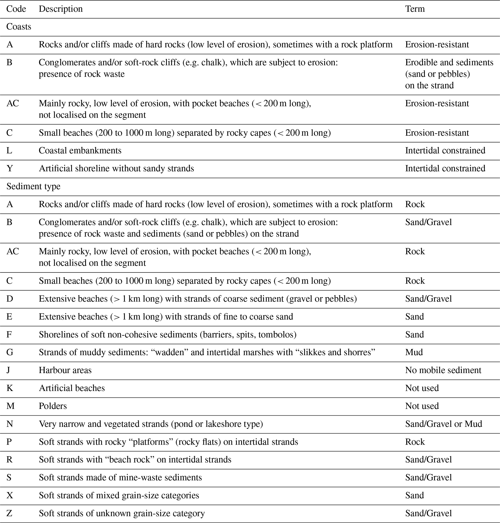
Table A2Simplified CoCliCo land cover classification derived from Corine.
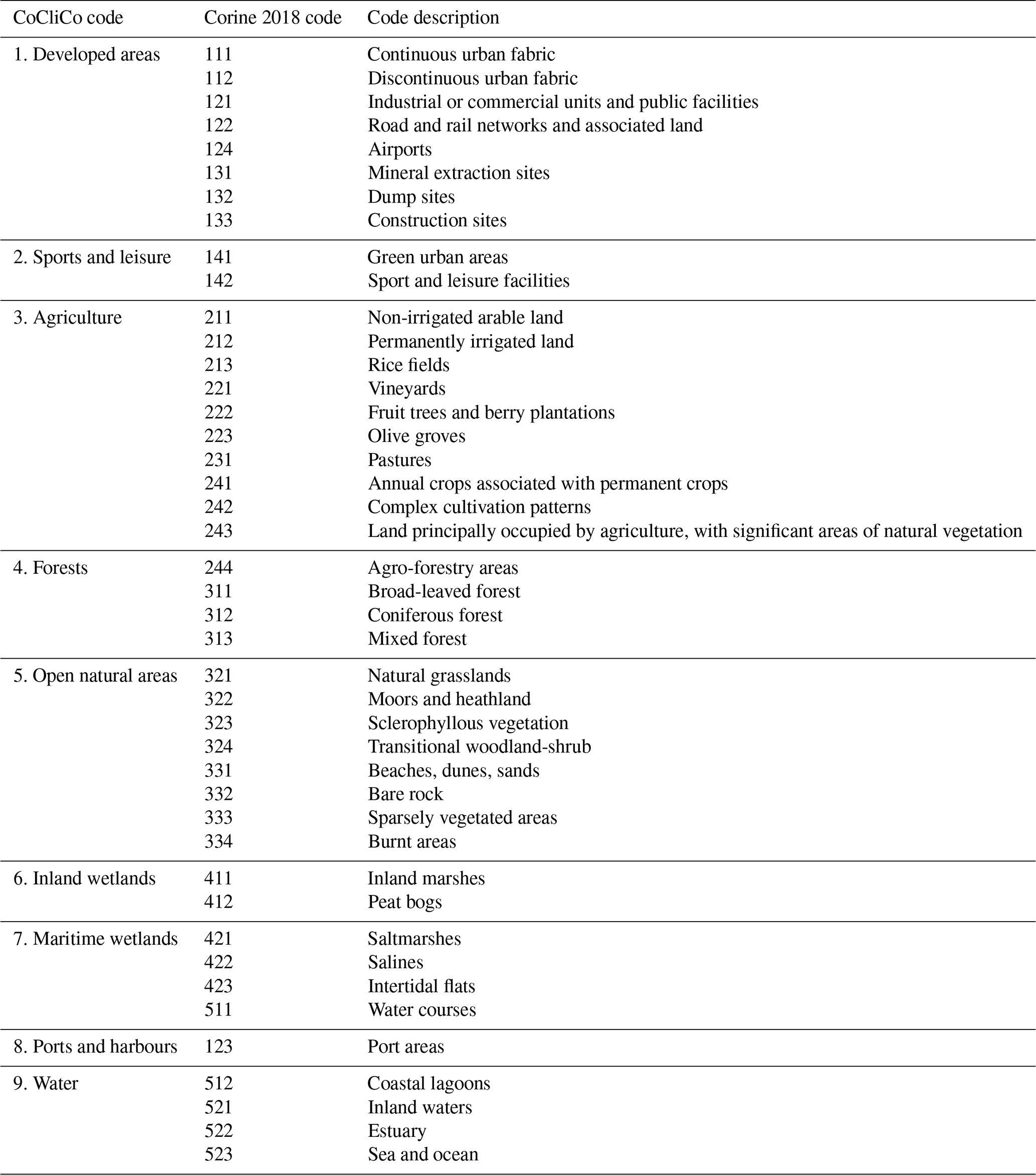
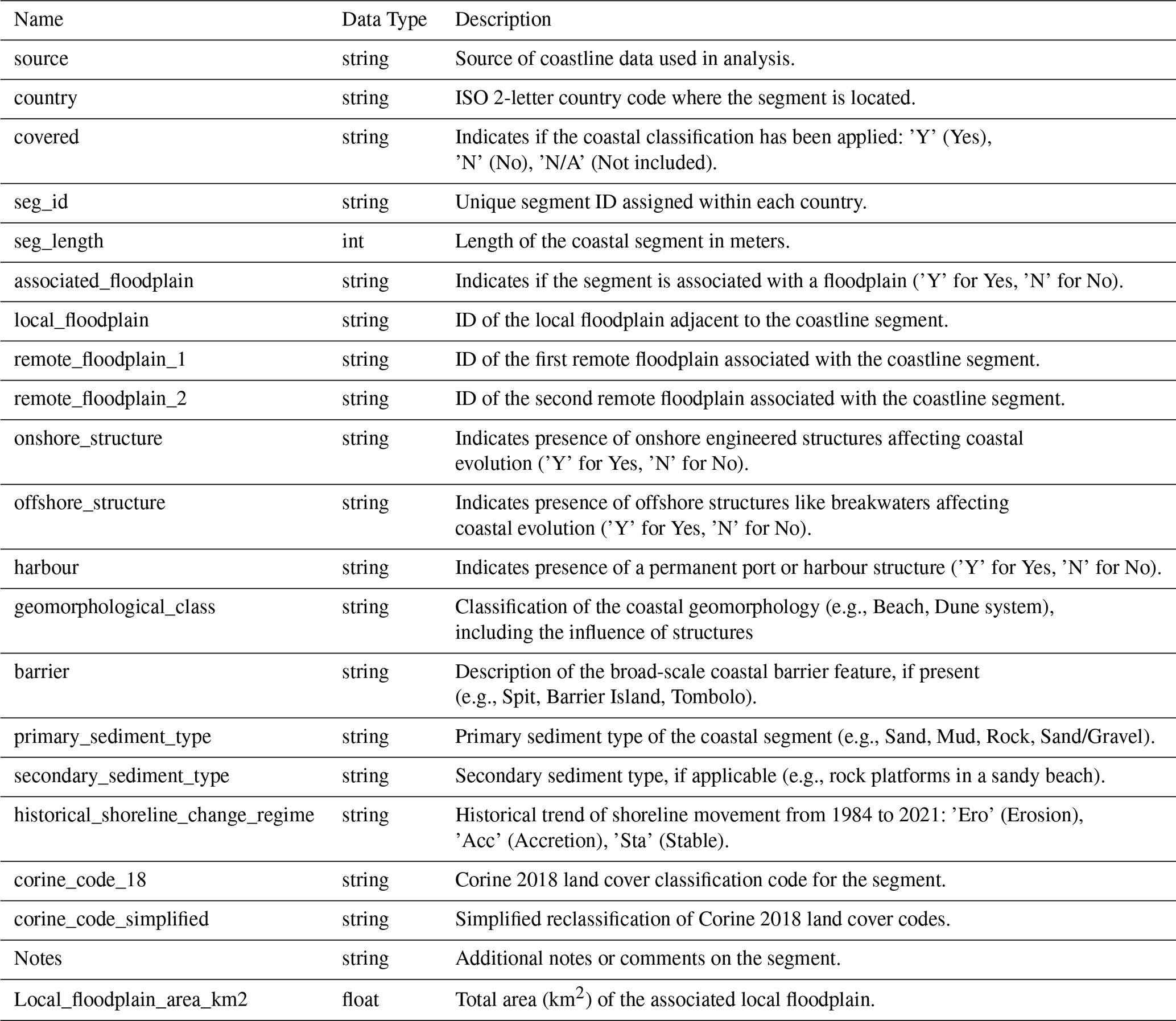
Table B1List of coastal attributes and descriptions in the CoasTER database.
The CoasTER database is available as a download in cloud-optimized format and described in a STAC collection produced using CoastPy (see Calkoen et al., 2025).
Project/platform website: https://coclicoservices.eu/ (last access: 25 March 2026).
Python guidance tutorials: https://github.com/openearth/coclico-workbench/tree/main/tutorials (last access: 25 March 2026).
STAC data location: https://minio.dive.edito.eu/project-coclico/coclico-stac-edito/catalog.json (last access: 25 March 2026).
Floodplain data: https://doi.org/10.5281/zenodo.19233592 (Lincke, 2026).
SH developed and constructed the database with conceptual and practical support from RN, FC GL and AL. SH prepared the manuscript with contributions from all co-authors.
The contact author has declared that none of the authors has any competing interests.
Publisher's note: Copernicus Publications remains neutral with regard to jurisdictional claims made in the text, published maps, institutional affiliations, or any other geographical representation in this paper. The authors bear the ultimate responsibility for providing appropriate place names. Views expressed in the text are those of the authors and do not necessarily reflect the views of the publisher.
This article is part of the special issue “Improving the contribution of land cryosphere to sea level rise projections (TC/GMD/NHESS/OS inter-journal SI)”. It is not associated with a conference.
Thanks to other members of the CoCliCo project who allowed their research to be included in the CoasTER database, especially Daniel Lincke (GCF), to Manuel Garcin and Rodrigo Pedreros (BRGM) for the use of their image in Fig. 1, and to Jack Heslop (University of East Anglia) for his suggestions and assistance.
This work was carried out as part of the CoCliCo (Coastal Climate Core Services) Project supported by the EU Horizon 2020 programme “Fighting and adapting to climate change” (grant no. 101003598).
This paper was edited by Animesh Gain and reviewed by two anonymous referees.
Almar, R., Ranasinghe, R., Bergsma, E. W. J., Diaz, H., Melet, A., Papa, F., Vousdoukas, M., Athanasiou, P., Dada, O., Almeida, L. P., and Kestenare, E.: A global analysis of extreme coastal water levels with implications for potential coastal overtopping, Nat. Commun., 12, 3775, https://doi.org/10.1038/s41467-021-24008-9, 2021.
Andrade, M. J., Jiménez-Morales, E., Rodríguez-Ramos, R., and Martínez-Ramírez, P.: Reuse of port industrial heritage in tourist cities: Shipyards as case studies, Frontiers of Architectural Research, 13, 164–183, https://doi.org/10.1016/j.foar.2023.09.005, 2024.
Athanasiou, P., van Dongeren, A., Pronk, M., Giardino, A., Vousdoukas, M., and Ranasinghe, R.: Global Coastal Characteristics (GCC): a global dataset of geophysical, hydrodynamic, and socioeconomic coastal indicators, Earth Syst. Sci. Data, 16, 3433–3452, https://doi.org//10.5194/essd-16-3433-2024, 2024.
Bateman, M. D., McHale, K., Bayntun, H. J., and Williams, N.: Understanding historical coastal spit evolution: A case study from Spurn, East Yorkshire, UK, Earth Surf. Proc. Land., 45, 3670–3686, https://doi.org/10.1002/esp.4991, 2020.
BGS: GeoCoastOpen, British Geological Society, https://www.bgs.ac.uk/datasets/geocoast-open/ (last access: 16 May 2025), 2023.
Bird, E.: Coastal changes: a global review, Wiley, New York, USA, 219 pp., ISBN 0-471-90646-8, 1985.
Brand, E., Ramaekers, G., and Lodder, Q.: Dutch experience with sand nourishments for dynamic coastline conservation – An operational overview, Ocean Coast. Manage., 217, 106008, https://doi.org/10.1016/j.ocecoaman.2021.106008, 2022.
Calkoen, F. R., Luijendijk, A. P., Vos, K., Kras, E., and Baart, F.: Enabling coastal analytics at planetary scale, Environ. Modell. Softw., 183, 106257, https://doi.org/10.1016/j.envsoft.2024.106257, 2025.
Castelle, B., Guillot, B., Marieu, V., Caumillon, E., Hanquiez, V., Bujan, S., and Poppeschi, C.: Spatial and temporal patterns of shoreline change of a 280-km high-energy disrupted sandy coast from 1950 to 2014: SW France, Estuar. Coast. Shelf S., 200, 212–223, https://doi.org/10.1016/j.ecss.2017.11.005, 2018.
CLC: CORINE Land Cover 2018 (vector), Europe, 6-yearly - version 2020_20u1, May 2020, EEA geospatial data catalogue [data set], https://doi.org/10.2909/71c95a07-e296-44fc-b22b-415f42acfdf0, 2020.
de Schipper, M. A., Ludka, B. C., Raubenheimer, B., Luijendijk, A. P., and Schlacher, T. A.: Beach nourishment has complex implications for the future of sandy shores, Nature Reviews Earth & Environment, 2, 70–84, https://doi.org/10.1038/s43017-020-00109-9, 2021.
Dullaart, J. C. M., Muis, S., Bloemendaal, N., Chertova, M. V., Couasnon, A., and Aerts, J. C. J. H.: Accounting for tropical cyclones more than doubles the global population exposed to low-probability coastal flooding, Communications Earth & Environment, 2, 135, https://doi.org/10.1038/s43247-021-00204-9, 2021.
EA: National Coastal Erosion Risk Mapping (NCERM): https://environment.data.gov.uk/dataset/9fede91f-5acd-4fd2-9bd8-98153fa3c2ff, last access: 19 November 2025.
EEA: Geology and geomorphology (EUROSION), Retrieved April 2023, from https://www.eea.europa.eu/data-and-maps/figures/geology-and-geomorphology, 2004.
EEA: coastline for analysis [dataset]: Retrieved April 2023, from https://sdi.eea.europa.eu/catalogue/srv/api/records/af40333f-9e94-4926-a4f0-0a787f1d2b8f, 2017.
Enwright, N. M., Griffith, K. T., and Osland, M. J.: Barriers to and opportunities for landward migration of coastal wetlands with sea-level rise, Frontiers in Ecology and the Environment, 14, 307–316, https://doi.org/10.1002/fee.1282, 2016.
Esri: Esri World Imagery, https://www.arcgis.com/home/item.html?id=10df2279f9684e4a9f6a7f08febac2a9 (last access: 19 November 2024), 2024.
EU-DEM: Copernicus European Digital Elevation Model, Eurostat [dataset], https://ec.europa.eu/eurostat/web/gisco/geodata/digital-elevation-model/eu-dem (last access: 10 April 2023), 2016.
Eurosion: D2.3.3 Eurosion Dataset Structure Description, European Commission Contract nr. B4-3301/2001/329175/MAR/B3, http://www.eurosion.org/reports-online/databasestructure.pdf (last access: 19 April 2023), 2003.
Eurosion: EUROSION portal, http://www.eurosion.org/home/main.html (last access: 18 January 2025), 2004.
Finkl, C. W.: Coastal classification: Systematic approaches to consider in the development of a comprehensive scheme, J. Coastal Res., 20, 166–213, https://doi.org/10.2112/1551-5036(2004)20[166:CCSATC]2.0.CO;2, 2004.
Foster, N. M., Hudson, M. D., Bray, S., and Nicholls, R. J.: Intertidal mudflat and saltmarsh conservation and sustainable use in the UK: A review, J. Environ. Manage., 126, 96–104, https://doi.org/10.1016/j.jenvman.2013.04.015, 2013.
Georgic, W. and Klaiber, H. A.: A flood of construction: The role of levees in urban floodplain development, Land Econ., 98, 78–97, https://doi.org/10.3368/le.98.1.071520-0106R1, 2022.
Gerard, F. and Lang, M.: Xynthia : analyse des causes et des conséquences de la catastrophe, La Houille Blanche, 105, 149–156, https://doi.org/10.1051/lhb/2019025, 2019.
Google Earth: https://earth.google.com/web (last access: 23 May 2025), 2024.
Grases, A., Gracia, V., García-León, M., Lin-Ye, J., and Sierra, J. P.: Coastal flooding and erosion under a changing climate: Implications at a low-lying coast (Ebro Delta), Water, 12, https://doi.org/10.3390/w12020346, 2020.
Hagenaars, G., de Vries, S., Luijendijk, A. P., de Boer, W. P., and Reniers, A. J. H. M.: On the accuracy of automated shoreline detection derived from satellite imagery: A case study of the sand motor mega-scale nourishment, Coast. Eng., 133, 113–125, https://doi.org/10.1016/j.coastaleng.2017.12.011, 2018.
Hanson, H., Brampton, A., Capobianco, M., Dette, H. H., Hamm, L., Laustrup, C., Lechuga, A., and Spanhoff, R.: Beach nourishment projects, practices, and objectives – a European overview, Coast. Eng., 47, 81–111, https://doi.org/10.1016/S0378-3839(02)00122-9, 2002.
Hanson, S., Nicholls, R. J., Balson, P., Brown, I., French, J. R., Spencer, T., and Sutherland, W. J.: Capturing coastal geomorphological change within regional integrated assessment: An outcome-driven fuzzy logic approach, J. Coastal Res., 26, 831–842, https://doi.org/10.2112/jcoastres-d-09-00078.1, 2010.
Hinkel, J., Nicholls, R. J., Tol, R. S. J., Wang, Z. B., Hamilton, J. M., Boot, G., Vafeidis, A. T., McFadden, L., Ganopolski, A., and Klein, R. J. T.: A global analysis of erosion of sandy beaches and sea-level rise: An application of DIVA, Global Planet. Change, 111, 150–158, https://doi.org/10.1016/j.gloplacha.2013.09.002, 2013.
Hudson, R., Kenworthy, J., and Best, M. (Eds.): Saltmarsh Restoration Handbook: UK and Ireland, UK Environment Agency, Bristol, UK, https://catchmentbasedapproach.org/learn/saltmarsh-restoration-handbook/ (last access: 25 March 2026), 2021.
Hulskamp, R., Luijendijk, A., van Maren, B., Moreno-Rodenas, A., Calkoen, F., Kras, E., Lhermitte, S., and Aarninkhof, S.: Global distribution and dynamics of muddy coasts, Nat. Commun., 14, 8259, https://doi.org/10.1038/s41467-023-43819-6, 2023.
Jiménez, J. A., Winter, G., Bonaduce, A., Depuydt, M., Galluccio, G., van den Hurk, B., Meier, H. E. M., Pinardi, N., Pomarico, L. G., and Vazquez Riveiros, N.: Sea Level Rise in Europe: Knowledge gaps identified through a participatory approach, in: Sea Level Rise in Europe: 1st Assessment Report of the Knowledge Hub on Sea Level Rise, edited by: , Copernicus Publications, State Planet, 3-slre1, 3, https://doi.org/10.5194/sp-3-slre1-3-2024, 2024.
Kennedy, D. M., McInnes, K. L., and Ierodiaconou, D.: Understanding coastal erosion on beaches: A guide for managers, policy makers and citizen scientists, Earth System and Climate Change Hub of the Australian Government's National Environmental Science Program (National Centre for Coasts & Climate) and the Department of Environment, Land, Water and Planning (Victorian Coastal Monitoring Program), https://www.marineandcoasts.vic.gov.au/__data/assets/pdf_file/0029/444683/Understanding-coastal-erosion-on-beaches-booklet.pdf (last access: 25 March 2026), 2019.
Leaman, C. K., Harley, M. D., Splinter, K. D., Thran, M. C., Kinsela, M. A., and Turner, I. L.: A storm hazard matrix combining coastal flooding and beach erosion, Coast. Eng., 170, 104001, https://doi.org/10.1016/j.coastaleng.2021.104001, 2021.
Le Cozannet, G., Bulteau, T., Garcin, M., Garnier, C., Müller, H., Hoareau, A., and Mallet, C.: Detecting errors in coastal databases using Bayesian Networks, J. Coastal Res., 75, 1162–1166, https://doi.org/10.2112/si75-233.1, 2016.
Le Cozannet, G., Nicholls, R. J., Hinkel, J., Sweet, W. V., McInnes, K. L., Van de Wal, R. S. W., Slangen, A. B. A., Lowe, J. A., and White, K. D.: Sea level change and Coastal Climate Services: The way forward, Journal of Marine Science and Engineering, 5, 49, https://doi.org/10.3390/jmse5040049, 2017.
Le Cozannet, G., Oliveros, C., Brivois, O., Giremus, A., Garcin, M., and Lavigne, F.: Detecting changes in European shoreline evolution trends using Markov chains and the Eurosion database, Frontiers in Marine Science, 7, 326, https://doi.org/10.3389/fmars.2020.00326, 2020.
Le Cozannet, G., Nicholls, R. J., Durand, G., Slangen, A. B. A., Lincke, D., and Chapuis, A.: Adaptation to multi-meter sea-level rise should start now, Environ. Res. Lett., 18, 091001, https://doi.org/10.1088/1748-9326/acef3f, 2023.
Le Cozannet, G., Sayers, P., Nicholls, R. J., Hinkel, J., Losada, I. J., Melet, A., Luijendijk, A., Koks, E., Lincke, D., Loukogeorgaki, E., Sannino, G., Vafeidis, A. T., Castañer, C. M., Kras, E., Menendez, M., Toimil, A., Völz, V., Thiéblemont, R., Bascoul, V., Bonatz, H., and Penning-Rowsell, E.: Coastal zones are under pressure from climate change: Transformational adaptation is needed, Zenodo, https://doi.org/10.5281/zenodo.15176253, 2025.
Lincke, D.: European coastline/floodplain segmentation for CoCliCo project, Zenodo [data set], https://doi.org/10.5281/zenodo.19233592, 2026.
Lincke, D. and Hinkel, J.: Report and final GIS layer of flood risk management units, CoCliCo project deliverable 6.2, https://coclicoservices.eu/wp-content/uploads/2021/11/WP6_D6.2.Report-and-final-GIS-layer-of-flood-risk-management-units.pdf (last access: 25 March 2026), 2023.
Linnér, H. and Messing, I.: Agricultural land needs protection, Acta Agr. Scand. B-S. P., 62, 706–710, https://doi.org/10.1080/09064710.2012.697574, 2012.
Luijendijk, A., Hagenaars, G., Ranasinghe, R., Baart, F., Donchyts, G., and Aarninkhof, S.: The state of the world's beaches, Scientific Reports, 8, 6641, https://doi.org/10.1038/s41598-018-24630-6, 2018.
Marine Scotland: Coastal erosion and flood risk management, https://marine.gov.scot/sma/assessment/coastal-erosion-and-flood-risk-management (last access: 25 March 2026), 2020.
Masselink, G., Russell, P., Rennie, A., Brooks, S., and Spencer, T.: Impacts of climate change on coastal geomorphology and coastal erosion relevant to the coastal and marine environment around the UK, MCCIP Science Review, 158–189, https://doi.org/10.14465/2020.arc08.cgm, 2020.
McInnes, K. L., Nicholls, R. J., van de Wal, R., Behar, D., Haigh, I. D., Hamlington, B. D., Hinkel, J., Hirschfeld, D., Horton, B. P., Melet, A., Palmer, M. D., Robel, A. A., Stammer, D., and Sullivan, A.: Perspective on regional sea-level change and coastal impacts, Cambridge Prisms: Coastal Futures, 2, e16, https://doi.org/10.1017/cft.2024.15, 2024.
Mentaschi, L., Vousdoukas, M. I., Pekel, J.-F., Voukouvalas, E., and Feyen, L.: Global long-term observations of coastal erosion and accretion, Scientific Reports, 8, 12876, https://doi.org/10.1038/s41598-018-30904-w, 2018.
Morales, J. A.: Coastal elements: Types of coasts and criteria in coastal classifications, in: Coastal Geology, edited by: Morales, J. A., Springer Nature Switzerland, Cham, 31–44, https://doi.org/10.1007/978-3-030-96121-3_4, 2022.
Oppenheimer, M., Glavovic, B. C., Hinkel, J., van de Wal, R., Magnan, A. K., Abd-Elgawad, A., Cai, R., Cifuentes-Jara, M., DeConto, R. M., Ghosh, T., Hay, J., Isla, F., Marzeion, B., Meyssignac, B., and Sebesvari, Z.: Chapter 4: Sea level rise and implications for low-lying islands, coasts and communities, in: Special Report on the Ocean and Cryosphere in a Changing Climate, edited by: Pörtner, H.-O., Roberts, D. C., Masson-Delmotte, V., Zhai, P., Tignor, M., Poloczanska, E., Mintenbeck, K., Alegría, A., Nicolai, M., Okem, A., Petzold, J., Rama, B., and Weyer, N. M., IPCC, 321–445, https://doi.org/10.1017/9781009157964.006, 2019.
Pang, T., Wang, X., Nawaz, R. A., Keefe, G., and Adekanmbi, T.: Coastal erosion and climate change: A review on coastal-change process and modeling, Ambio, 52, 2034–2052, https://doi.org/10.1007/s13280-023-01901-9, 2023.
Pedreros, R., Garcin, M., Krien, Y., Monfort Climent, D., Mujica, J., and Francois, B.: Tempête Xynthia : compte rendu de mission préliminaire, BGRM, Rapport BRGM/RP-58261-FR, 53 pp., https://infoterre.brgm.fr/rapports/RP-58261-FR.pdf (last access: 25 March 2026), 2010.
Pollard, J., Spencer, T., and Brooks, S.: The interactive relationship between coastal erosion and flood risk, Prog. Phys. Geog., 43, 574–585, https://doi.org/10.1177/0309133318794498, 2019.
Pollard, J. A.: Climate change and coastal policy: the need to address erosion-flooding interactions for effective coastal risk management, Geography, 104, 60–70, 2019.
Pontee, N.: Defining coastal squeeze: A discussion, Ocean Coast. Manage., 84, 204–207, https://doi.org/10.1016/j.ocecoaman.2013.07.010, 2013.
Pranzini, E. and Williams, A. (Eds.): Coastal erosion and protection in Europe, 1st edn., Routledge, https://doi.org/10.4324/9780203128558, 2013.
Pranzini, E., Wetzel, L., and Williams, A. T.: Aspects of coastal erosion and protection in Europe, J. Coast. Conserv., 19, 445–459, https://doi.org/10.1007/s11852-015-0399-3, 2015.
Quelennec, R. E., De Moor, G., Dillingh, D., Lewis, A. W., Marques, M. A., May, V., Møller, J. T., Oliveros, C., Soares de Carvalho, G., and Zamani, A.: Corine Coastal Erosion: Atlas of the geomorphology and evolutionary trends of the European coasts of the European Community, Office for Official Publications of the EC, Luxembourg, GD Luxembourg, http://hdl.handle.net/1854/LU-113409 (last access: 25 March 2026), 1998
Schuerch, M., Spencer, T., Temmerman, S., Kirwan, M. L., Wolff, C., Lincke, D., McOwen, C. J., Pickering, M. D., Reef, R., Vafeidis, A. T., Hinkel, J., Nicholls, R. J., and Brown, S.: Future response of global coastal wetlands to sea-level rise, Nature, 561, 231–234, https://doi.org/10.1038/s41586-018-0476-5, 2018.
Scott, C. R., Harris, E., and Townend, I. H.: Lessons in applying adaptive management on a dynamic coastline: a case study at the inlet to Pagham Harbour, UK, Anthropocene Coasts, 3, 86–115, https://doi.org/10.1139/anc-2019-0002, 2020.
Stéphan, P., Suanez, S., Guérin, T., Rivier, A., Leballeur, L., Waeles, B., Ammann, J., and Houron, J.: Breaching of the Sillon de Talbert gravel spit (North Brittany, France) and coastal flooding risk assessment, Geomorphology, 461, 109302, https://doi.org/10.1016/j.geomorph.2024.109302, 2024.
Stive, M. J. F., Aarninkhof, S. G. J., Hamm, L., Hanson, H., Larson, M., Wijnberg, K. M., Nicholls, R. J., and Capobianco, M.: Variability of shore and shoreline evolution, Coast. Eng., 47, 211–235, https://doi.org/10.1016/S0378-3839(02)00126-6, 2002.
Toimil, A., Álvarez-Cuesta, M., and Losada, I. J.: Neglecting the effect of long- and short-term erosion can lead to spurious coastal flood risk projections and maladaptation, Coast. Eng., 179, 104248, https://doi.org/10.1016/j.coastaleng.2022.104248, 2023.
van de Wal, R., Melet, A., Bellafiore, D., Camus, P., Ferrarin, C., Oude Essink, G., Haigh, I. D., Lionello, P., Luijendijk, A., Toimil, A., Staneva, J., and Vousdoukas, M.: Sea Level Rise in Europe: Impacts and consequences, in: Sea Level Rise in Europe: 1st Assessment Report of the Knowledge Hub on Sea Level Rise (SLRE1), edited by: van den Hurk, B., Pinardi, N., Kiefer, T., Larkin, K., Manderscheid, P., and Richter, K., Copernicus Publications, State Planet, 3-slre1, 5, https://doi.org/10.5194/sp-3-slre1-5-2024, 2023.
van Rijn, L. C.: Coastal erosion and control, Ocean Coast. Manage., 54, 867–887, https://doi.org/10.1016/j.ocecoaman.2011.05.004, 2011.
Vos, K., Splinter, K. D., Palomar-Vázquez, J., Pardo-Pascual, J. E., Almonacid-Caballer, J., Cabezas-Rabadán, C., Kras, E. C., Luijendijk, A. P., Calkoen, F., Almeida, L. P., Pais, D., Klein, A. H. F., Mao, Y., Harris, D., Castelle, B., Buscombe, D., and Vitousek, S.: Benchmarking satellite-derived shoreline mapping algorithms, Communications Earth & Environment, 4, 345, https://doi.org/10.1038/s43247-023-01001-2, 2023.
Vousdoukas, M. I., Ranasinghe, R., Mentaschi, L., Plomaritis, T. A., Athanasiou, P., Luijendijk, A., and Feyen, L.: Sandy coastlines under threat of erosion, Nat. Clim. Change, 10, 260–263, https://doi.org/10.1038/s41558-020-0697-0, 2020.
Wen, L., Glasby, T. M., and Hughes, M. G.: The race for space: Modelling the landward migration of coastal wetlands under sea level rise at regional scale, Sci. Total Environ., 859, 160483, https://doi.org/10.1016/j.scitotenv.2022.160483, 2023.
Wolff, C., Vafeidis, A. T., Muis, S., Lincke, D., Satta, A., Lionello, P., Jimenez, J. A., Conte, D., and Hinkel, J.: A Mediterranean coastal database for assessing the impacts of sea-level rise and associated hazards, Scientific Data, 5, 180044, https://doi.org/10.1038/sdata.2018.44, 2018.
Woodroffe, C. D.: Coasts: Form, Process and Evolution, Cambridge University Press, Cambridge, https://doi.org/10.1017/CBO9781316036518, 2002.
Zuo, J., Zhang, L., Chen, B., Zhang, B., Ruan, L., Hu, Y., Mamun, M. M. A. A., and Raza, S. A.: GCSD: A comprehensive coastal indicators database for global coastal sustainable development assessment, Scientific Data, 12, 1562, https://doi.org/10.1038/s41597-025-05668-4, 2025.
- Abstract
- Graphical abstract
- Introduction
- Background
- The CoCliCo Coastal Typologies and Erosion for Risk (CoasTER) database
- Erosion and floodplain interactions around the European coast
- Discussion
- Conclusions
- Appendix A
- Appendix B
- Data availability
- Author contributions
- Competing interests
- Disclaimer
- Special issue statement
- Acknowledgements
- Financial support
- Review statement
- References