the Creative Commons Attribution 4.0 License.
the Creative Commons Attribution 4.0 License.
 | 28 Oct 2025
Understanding extreme-wave hazards on high-energy coasts requires a standardised approach to field data collection: analysis and recommendations
Mary C. Bourke
Max Engel
Andrew B. Kennedy
Annie Lau
Serge Suanez
Sarah J. Boulton
Maria Alexandra Oliveira
Raphaël Paris
Dimitra Salmanidou
Michaela Spiske
Wayne Stephenson
Storm Roberts
Adam D. Switzer
Nadia Mhammdi
Niamh D. Cullen
Masashi Watanabe
Coastal boulder deposits provide vital information on extreme wave events. They are crucial for understanding storm and tsunami impacts on rocky coasts, and for understanding long-term hazard histories. But study of these deposits is still a young field, and growth in investigation has been rapid, without much contact between research groups. Therefore, inconsistencies in field data collection among different studies hinder cross-site comparisons and limit the applicability of findings across disciplines. This paper analyses field methodologies for coastal boulder deposit measurement based using an integrated database (ISROC-DB), and demonstrates inconsistencies in current approaches. We use the analysis as a basis for outlining protocols to improve data comparability and utility for geoscientists, engineers, and coastal planners. Using standardised and comprehensive data reporting with due attention to precision and reproducibility – including site characteristics, boulder dimensions, complete positional data, tide characteristics, and geodetic and local topographic datum information – will help ensure complete data retrieval in the field. Applying these approaches will further ensure that data collected at different times and/or locations, and by different groups, is useful not just for the study being undertaken, but for other researchers to analyse and reuse. We hope to foster development of the large, internally consistent datasets that are the basis for fruitful meta-analysis. This is particularly important given increasing focus on long-term monitoring of coastal change. By recommending a common set of measurements, adaptable to available equipment and personnel, this work aims to support accurate and thorough coastal boulder deposit documentation, enabling broader applicability and future-proofed datasets. Field protocols described and recommended here also apply as best practices for coastal geomorphology field work in general.
- Article
(5988 KB) - Full-text XML
-
Supplement
(521 KB) - BibTeX
- EndNote


Coastal boulder deposits (Fig. 1) occur on rocky or coral reef coasts that are subject to intense ocean forces. Constituent clasts are moved by waves (in many cases against gravity), and are stranded in place on rocky coasts (Fig. 1a–e) or reef flats (Fig. 1f). Coastal boulder deposits thus record extreme marine inundation, but they are still poorly understood. The transporting agent may be storm waves or tsunami, and in some places both may operate at different times; but we still lack definitive indicators (other than before-and-after imagery) to uniquely identify the transporting mechanism from deposit characteristics. However, coastal boulder deposits are often the only preserved signatures of high energy inundation on rocky coastlines, providing direct links to past emplacement and transport conditions. Decoding this record is therefore important for long-range coastal risk analysis, with applications spanning climate reconstruction, seismology, environmental modelling, coastal engineering, and hazard assessment.
Study of these enigmatic deposits is still in its infancy. There are some historical accounts of large boulder and coral-head emplacement by storm waves (e.g. O'Donovan, 1928; Stevenson, 1845; Stoddart, 1971; Süssmilch, 1912) and by tsunami (e.g. Kato and Kimura, 1983; Nakata and Kawana, 1995; Shepard et al., 1949), as well as a recognition that it could be very difficult to determine whether storms or tsunami were the causative mechanism (Bourrouilh-Le Jan and Talandier, 1985; Jones and Hunter, 1992). But there was little systematic study until seminal work in the 1990s and early 2000s (Bryant and Nott, 2001; Jones and Hunter, 1992; Nott, 1997, 2003b) started people thinking about the importance of coastal boulder deposits for understanding extreme wave hydrodynamics and hazards in the nearshore environment. This drove rapid growth in the number of publications, from less than one per year in the 1990s to an average of almost 20 per year over the past 10 years (Fig. 2). However, this is still a small overall number of studies by comparison with more established areas of inquiry, for example analysis of beaches or coastal dune fields, for which there may be hundreds of papers published per year.
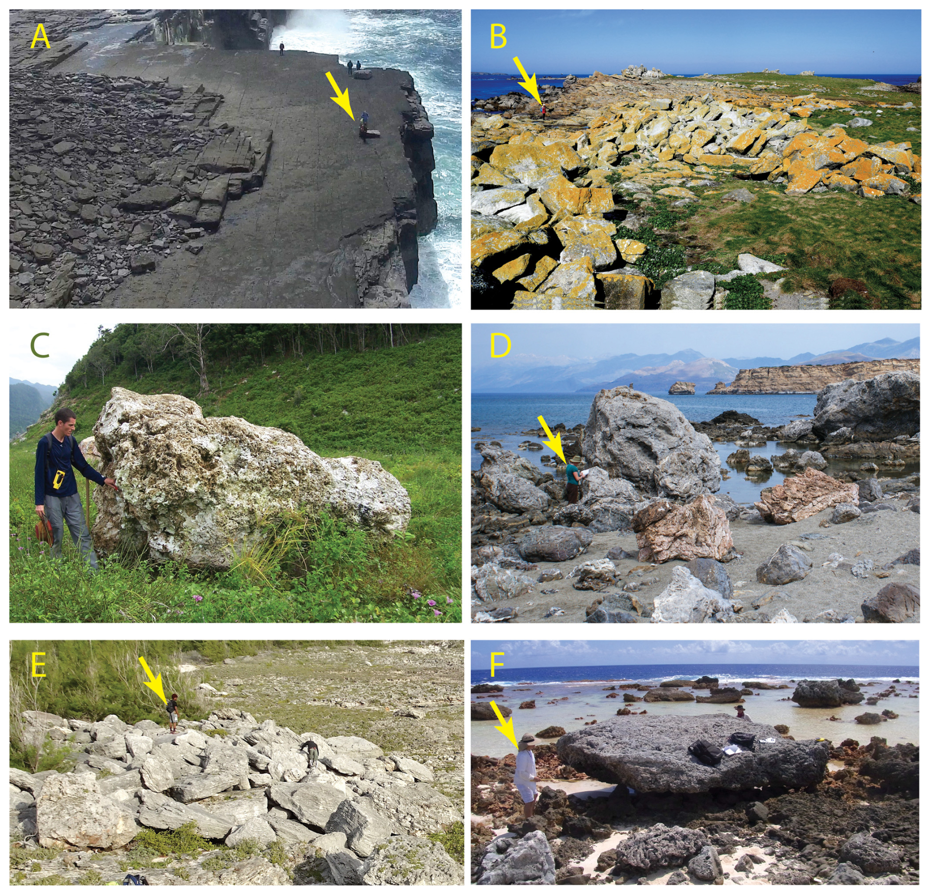
Figure 1Examples of coastal boulder deposits from a variety of locations. Each photo includes a person for scale (indicated with an arrow where they are difficult to see). (A) Aran Islands, Ireland. Broad boulder ridge (5 m high and 40 m wide) is 20 m above highest tide, and 35 m from the cliff edge (photo by Peter Cox). (B) Banneg Island, France. Boulder ridge is about 11 m above topographic datum IGN69 and 50 m inland (photo by Serge Suanez). (C) Aceh, Indonesia. Boulder (6.5 t) transported 132 m inland by 2004 tsunami (photo by Raphaël Paris). (D) Diplomo Petris, Crete. Boulder clusters in the intertidal zone (photo by Michael Whitworth). (E) Eleuthera, Bahamas. Base of deposit is 10 m above high water and 13 m inland (photo by Rónadh Cox). (F) Makemo Atoll, French Polynesia. Scattered reef-top boulders in the intertidal zone (photo by Annie Lau).
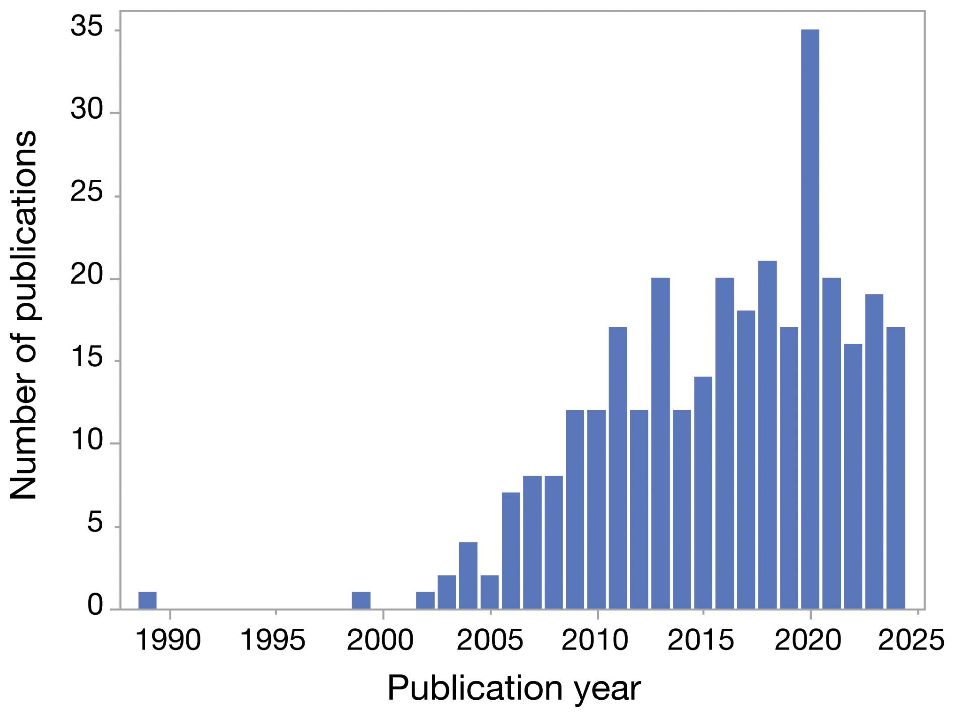
Figure 2Increase in coastal boulder deposit studies from the 1990s to present. Data are complete through the end of 2024. Compiled from Google Scholar using search string “coastal boulder deposit” OR “coastal boulder deposits” OR “megagravel” OR “megaclast deposit” OR “megaclast deposits” with “include citations” unchecked. Search returns were individually scrutinised and verified. For example, the citations filter was not flawless, so papers on other topics that simply cited coastal boulder work had to be identified and removed. Similarly, papers that mentioned coastal boulder deposits broadly in other contexts but did not study them directly were likewise excluded.
There is a lack of generally accepted best practices for coastal boulder deposit data collection and reporting. This is largely because of the rapid and relatively recent growth of this field, with a lack of centralised community and little communication between research groups. This is a problem, because coastal boulder deposits present many challenges in field measurement and documentation (which will be described below). With a large number of new researchers entering the field (including students embarking on early-career work and skilled scientists moving into a new arena), many people measuring coastal boulder deposits are doing it for the first time. Therefore, without a repository of information on standardised methodologies, there is a wide variety in the kinds of measurements collected and (as reported here) substantial inconsistency among published datasets. This creates difficulty in comparing datasets from different sites and work groups (Kennedy et al., 2025a), forming a barrier to objective, reliable comparative analysis, and an impediment to growth of synthetic understanding.
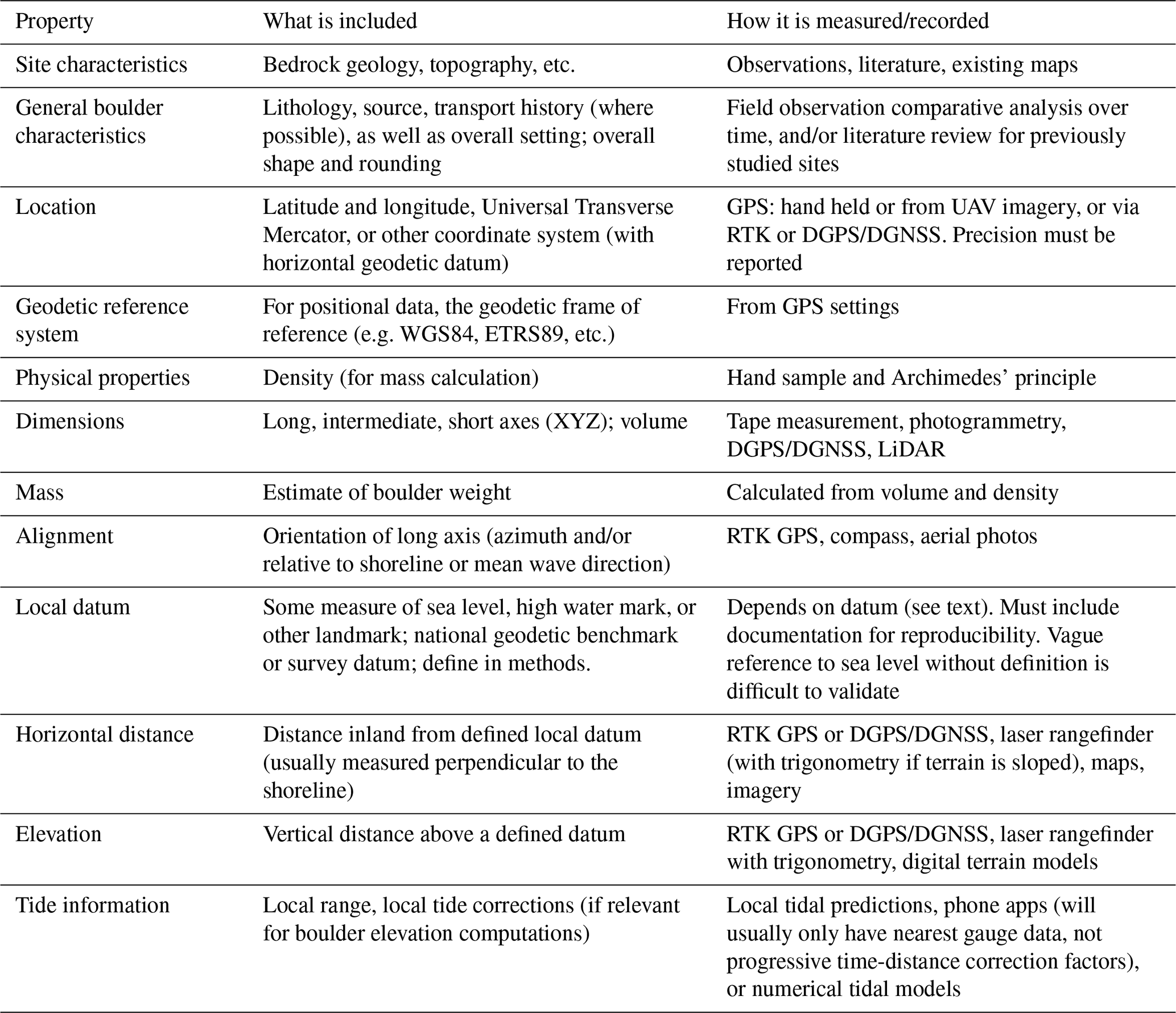
Table 1Recommended core data for coastal boulder deposit studies. Each property is described in detail in the text. Abbreviations: GPS = Global Positioning System; GNSS = Global Navigation Satellite System; DGPS or DGNSS = Differential GPS or GNSS; RTK = Real Time Kinematic; UAV = Uncrewed Aerial Vehicle or drone. A printable formatted version of this table, for use as a field-planning checklist, is included as a Supplement.
To demonstrate the lack of central similarity in coastal boulder deposit studies, and to quantify and evaluate the range of approaches taken, we carried out a meta-analysis of published data. We focused on measurements of individual boulders rather than broader mapping of boulder accumulations. However, many of the principles and recommendations laid out here apply equally well to documentation of boulder clusters or ridges, and can be adapted as necessary to those applications. Our exploration reveals a lot of variability in what people measure and how they measure it, and we use this analysis to make a case for community-wide consistency in data collection and reporting. We propose a set of core measurements that should accompany any coastal boulder deposit study (Table 1).
Our approach emphasises the systematic description, measurement, and characterisation of coastal boulder deposits, independent of their origin. Figuring out objective measures for distinguishing the deposits of tsunami from those of extreme storms is perhaps the single most important question in the coastal boulder deposit field (e.g. Bujan and Cox, 2020; Costa and Andrade, 2020; Lau and Autret, 2020; Mottershead et al., 2020; Oetjen et al., 2021; Weiss et al., 2022, and many others), but solving that puzzle requires evidence-based analysis that foregrounds the impartial collection of data. In this paper therefore we will not discuss different processes by which features may have formed, but focus on precise and accurate characterisation of the deposits, for the production of internally consistent datasets that facilitate comparison among sites and over time. Although we focus on coastal boulder deposits, the protocols we outline are applicable to a wide range of coastal geomorphologic settings and may be considered as general best practices.
Position papers such as this play a crucial role in shaping methodologies used for data collection, providing a foundation for standardised practices across diverse research and applied fields. By outlining best practices, challenges, and guiding principles, this contribution will facilitate a unified approach to data collection that enhances comparability, reliability, and reproducibility. This work will also contribute to the broader scientific community by setting a benchmark for data quality, encouraging transparency, and fostering collaboration. We hope this work will encourage both new and experienced researchers to use a common framework, helping reduce discrepancies and improving the integration of datasets from multiple sources.
Coastal boulder deposits take a variety of forms, ranging from isolated single blocks (Fig. 1c) to extensive boulder ridges (Fig. 1a, b) (as will be discussed in more detail below). The name highlights the predominance of boulders (i.e. intermediate axis >0.25 m: Udden, 1914; Wentworth, 1922) but coastal boulder deposits can include a broad sweep of clast sizes. They often include colossal blocks in the megagravel size class (i.e. intermediate axis greater than 4.1 m, as defined by Blair and McPherson, 1999). Examples include boulders 15 m × 11 m × 9 m in Tonga (Frohlich et al., 2009), 15 m × 10 m × 5 m in Tuamotu (Bourrouilh-Le Jan and Talandier, 1985), and 11 m × 10 m × 3 m on Ireland's Aran Islands (Cox et al., 2018b). But many accumulations also incorporate much smaller gravel trapped in spaces between the large framework clasts (e.g. Cox et al., 2012; Paris et al., 2011; Scheffers et al., 2009). Boulders not emplaced by waves (e.g. those that fall from cliffs or are brought to the coast by rivers) are not included in this definition, unless they are subsequently entrained and re-deposited by wave action.
Because of the amount of energy required to displace them, coastal boulder deposits may be dormant for extended periods (multiple years to decades to centuries, depending on the topography, clast size and wave climate). The protracted timescales complicate efforts to interpret their hydrodynamics and to untangle the relative roles of extreme storms versus tsunami. Nevertheless, these long-lived deposits provide what are sometimes the only records of historic and prehistoric coastal inundation, and therefore reconstructions have direct application to understanding past and present conditions, and have predictive value for future inundation regimes.
The first recorded use of the term “coastal boulder deposits” is by Bishop and Hughes (1989). Since then it has gained progressively more traction and recognition as the formal name for wave-emplaced accumulations of large clasts that are out of equilibrium with the local wave climate and require extreme events for their transport. The advantage of this term is that it is general and non-genetic. This is important, as the origin of a majority of coastal boulder deposits remains in question, with relative roles of storm and/or tsunami still under debate. A unifying term that does not presuppose deposit origin provides maximum flexibility in description and analysis.
On that note, the phrase “cliff-top storm deposits” (Autret et al., 2016; Fichaut and Suanez, 2011; Hall et al., 2006; Suanez et al., 2009) has sometimes been applied as a synonym for coastal boulder deposits, but we recommend against its use because it can be misleading. First, the term “cliff” is quite loosely defined in geomorphology in both height and steepness, and thus means different things to different workers, making its use ambiguous. Second, and most importantly, embedding the term “storm” in the deposit name makes suppositions about the depositional mechanism, which creates problems for researchers trying to conduct objective analysis of depositional mechanisms. Whereas this term – and others such as reef-platform coral boulders (e.g. Terry et al., 2013) – have been useful for certain sites and applications, we argue that they should be discontinued in favour of the more general term “coastal boulder deposits”.
There are two distinct kinds of coastal boulder deposits – land-derived and reefal – characteristics of which are unpacked below.
2.1 Land-derived (terrigenous) coastal boulder deposits
Occurring along rocky coasts exposed to extreme wave energies, land-derived coastal boulder deposits originate by wave erosion of local igneous, metamorphic or sedimentary bedrock, whether from shore platforms, stepped or uneven exposures, or cliff edges. To be classified as coastal boulder deposits, howeer, they cannot simply have accumulated in place via collapse but must have been transported (usually against gravity) by waves.
They may occur as individual isolated clasts (Fig. 1c), irregular clusters (Fig. 1d), or highly organised imbricated boulder ridges (Fig. 1a, b, e) (Cox et al., 2018a; Spiske et al., 2008). Isolated clasts may form a field of widely-scattered boulders (Fig. 1f), or there may be just one or a few large boulders along a stretch of shoreline (Etienne et al., 2011; Frohlich et al., 2009; Lau and Autret, 2020; May et al., 2015). Clusters are aggregates of several boulders clumped together (Fig. 1d), sometimes showing seaward imbrication and in other cases forming disorganised groups or piles (Biolchi et al., 2019a; Evelpidou et al., 2020; Mhammdi et al., 2008). Ridges are highly organised coast-parallel features involving large numbers of clasts (hundreds to thousands), with an angle-of-repose face dipping steeply seaward and a more shallowly sloping landward side (Cox et al., 2012; Nott, 2003b; Suanez et al., 2009; Williams and Hall, 2004). Whereas clusters are rarely more than one or two clasts high, boulders in ridges can be stacked several deep, leading to accumulations that may be several metres tall, 10s of metres in cross-shore width, and which in some cases can extend for hundreds of metres along the coast (Cox et al., 2012; Etienne and Paris, 2010; Hall et al., 2006; Lau and Autret, 2020). Whereas isolated clasts or clusters might form during a single event, extensive ridge systems – sometimes referred to as ridge complexes (Morton et al., 2006, 2008) or ramparts (Scheffers et al., 2014) – are interpreted as representing the cumulative impacts of multiple extreme-wave events.
Placement is as diverse as the geomorphology of the rocky coasts that host these deposits. Some are found on cliff tops that may be several metres or even several tens of metres high (the highest known coastal boulder deposits occur about 50 m above sea level: Hall et al., 2006). Others occur at the inland edges of low-elevation shore platforms, up to several hundred metres inland (Cox et al., 2018b). On irregularly-stepped coasts, deposits can occur at multiple levels, often nucleating at bedrock steps or other obstacles that provide a backstop (Autret et al., 2023; Lau and Autret, 2020).
Location relative to water level is also varied. Many occur above the high-water level (not reached by the tide or by fairweather waves). Generally these supratidal deposits are found along bedrock coasts where wave energy is persistently high and the coastline is predominantly erosional, with negative sediment budgets. These high-and-dry boulders are therefore separated from the ocean by a bare bedrock surface swept clean of sand and fine gravel (Autret et al., 2023; Biolchi et al., 2019a; Engel and May, 2012; Hansom et al., 2008; Williams and Hall, 2004). At other sites, where backgound wave energy levels are lower, deposits may be found on beaches or in the intertidal zone (Abad et al., 2020; Engel et al., 2016; Whelan and Kelletat, 2005). And in some cases boulders can be cast far inland and may be found among vegetation (e.g. Atwater et al., 2017; Dunán-Avila et al., 2025; Goto et al., 2012; Jones and Hunter, 1992; Kennedy et al., 2017; Paris et al., 2010).
The size and shape of constituent boulders is controlled by lithology and planes of weakness (including joints, fractures, and bedding planes), which control the size and shape of boulders released from bedrock. Once formed, their transport history and locus of deposition are a complex function of wave energy and coastal topography. The largest blocks tend to be found at lower elevations near the coastline, with deposits at higher elevation and further inland generally being formed from smaller boulders, and as a general rule of thumb, the higher the elevation and/or the steeper the coast the smaller the maximum clast size; but datasets show that these trends are often noisy (Boesl et al., 2020; Cox et al., 2018a; Kennedy et al., 2021).
Boulders show variable amounts of transport-based breakage and rounding. This can be conrolled by lithology, jointing, and fracture mechanics; but also depends on how frequently they are moved around, which varies with boulder size, elevation, and distance inland (Biolchi et al., 2016; Cox et al., 2018a). Static boulders can also experience physical and chemical weathering in situ over long time periods, which may be mediated or accelerated by vegetation, cyanobacteria, lichens, intertidal organisms, or orther biogeochemical agents (e.g. Bahlburg and Spiske, 2015; Kelletat et al., 2020; Oliveira et al., 2020b).
2.2 Reefal coastal boulder deposits
Tropical settings with fringing reefs provide a special category of rocky coastline on which blocks excavated from the reef may be deposited by high-energy waves. This subset of coastal boulder deposits has distinct characteristics that differ from land-derived examples. First, boulders are sourced from modern reefs rather than lithified bedrock, which means that they are generally highly porous and less dense than bedrock-sourced boulders. Second, they often become grounded on reef flats that are submerged at high tide (e.g. Boesl et al., 2020; Etienne et al., 2011; Goto et al., 2007; Lau et al., 2014), which means that this category of coastal boulder deposits is commonly found within the intertidal zone (although some boulders may be transported onto the shores of adjacent islands and elevated substantially above the high water mark: Atwater et al., 2017; Bourrouilh-Le Jan and Talandier, 1985; Dunán-Avila et al., 2025; Nakata et al., 2023; Terry et al., 2013). Third, deposits on reef flats occur only as isolated blocks and/or small clusters. Organised shore-parallel boulder ridges are not found on the fringing reefs themselves, although reef-derived boulders that have been transported ashore may pile up (Lau and Autret, 2020). Finally, reefal boulders often have rounded shapes that are due to growth forms of the coral source material rather than abrasion during transport (Goto et al., 2010a; Lau et al., 2016). For example some coral species form almost spherical colonies that are transported more easily and farther inland than angular boulders of the same size (Massel and Done, 1993). As with terrestrial coastal boulder deposits, they may be created and/or modified by storm waves or by tsunami (e.g. Goto et al., 2010b; Lau et al., 2018). Reactivation and repositioning are similarly rare because of the intense energy required to move them (Terry et al., 2013)
Coastal boulder deposits serve as enduring indicators of both the impacts of marine hazards and the magnitude of inundation events. Each boulder pinpoints a minimum force exerted at some point in time to transport that mass to that location. This in itself is valuable information in terms of tracking coastal hazards; but to fully analyse long-term risk, we need to determine whether the inundation forces are due to storm waves or tsunami.
Early studies used boulder mass as the primary determinant of emplacement mechanism, contending that only tsunami were capable of moving the largest clasts (e.g. Scheffers et al., 2009; Young et al., 1996). This line of reasoning was based on a premise that the sustained force exerted by tsunami permitted them to move enormous masses despite relatively small wave heights, while for storm waves to move comparably large masses would require heights that were dynamically improbable. Some studies cited a lack of first-hand records showing storm-wave transport of very large boulders, especially at elevation or far inland (e.g. Scheffers et al., 2009) but most relied on hydrodynamic equations that purported to relate boulder transport to wave height as a determinant of whether storm waves could or could not move a given boulder (Barbano et al., 2010; Benner et al., 2010; Nott, 1997, 2003b; Pignatelli et al., 2009).
But this rationale fell apart in recent years, when pre- and post-event measurements at several different locations revealed storm-wave movement of blocks weighing hundreds of tonnes close to shorelines, as well as multi-tonne rocks deposited at tens of metres elevation or at inland distances up to a quarter kilometre (Biolchi et al., 2019b; Cox et al., 2018b; Kennedy et al., 2017; e.g. May et al., 2015; Medina et al., 2018). These observations of storm wave coastal boulder deposit transport led to greater scrutiny of widely used hydrodynamic equations relating transported masses to wave heights. The equations were shown to be based on assumptions that the physics of storm wave runup were fundamentally different from those of tsunami (in particular, that storm-generated bores could not achieve supercritical flow), but review of advances in wave dynamics (that had occurred in the decades after the equations were developed) showed that in fact those assumptions were not supported by data (Cox et al., 2020; Oetjen et al., 2021). Additional work on wave flow velocities required to initiate boulder movement (e.g. Nandasena et al., 2022) has further refined our understanding of how wave energy translates to boulder motions, providing tools to calculate realistic incipient motion velocities.
The upshot is that work in the past decade has confirmed a substantial overlap in the power of storm waves and tsunami. Storm-wave flows can be supercritical (Froude number >1) and exert tremendous forces (Bujan and Cox, 2020; Ma et al., 2024; Steer et al., 2021). This is exciting, and opens new avenues for investigation and understanding of extreme wave behaviour. But it is also frustrating because – with the sole exception of certain phenomenally large boulders, and those deposited at kilometre-scale distances from the shoreline (Goto et al., 2011; Terry et al., 2021) – it torpedoes any hope of distinguishing storm from tsunami deposits based on boulder size alone. Aseismic tsunami sources provide an additional complication because whereas earthquake-induced tsunami or large landslides create seismic events that can be detected geophysically, meteotsunami are harder to detect, and could go unnoticed (Gusiakov, 2021; Hansom et al., 2015).
Consequently, it has become increasingly clear that distinguishing storm from tsunami transport is a challenging and unsolved problem (e.g. Barbano et al., 2010; Costa and Andrade, 2020; Lau and Autret, 2020; Lorang, 2011; Marriner et al., 2017; Scardino et al., 2025; Weiss, 2012). An growing number of studies report primary observations that many coastal boulder deposits are generated and activated by storm waves (Autret et al., 2016; Biolchi et al., 2019b; Cox et al., 2018b; Goto et al., 2009; Kennedy et al., 2017; e.g. May et al., 2015; Medina et al., 2018; Naylor et al., 2016; Oliveira et al., 2020a; Scicchitano et al., 2020) and that for others transport and deposition are unequivocally due to tsunami (Bourgeois and MacInnes, 2010; Etienne et al., 2011; e.g. Goff et al., 2006; Goto et al., 2007; Nandasena et al., 2013).
Some characteristics do appear linked to wave type. For example, tsunami are not known to create organised boulder ridges (Etienne et al., 2011), but they can shift megagravel over extreme distances (>1 km) inland (Goto et al., 2010a); and storm-dominated boulder fields often show inland fining (Goto et al., 2009; Lau et al., 2014), compared to more random patterns in tsunami boulders (Boulton and Whitworth, 2017; Goto et al., 2012). However, none yet have been definitively proven to be unique markers.
Currently, the only way to make a fully confident determination is to have a smoking gun, whether from historical records (which are rare) or by capturing proof of the movement (using before-and-after imagery for extreme events). However, for the majority of coastal boulder deposits these data are not available, which means that researchers must weigh various other kinds of evidence (including local wave climate, regional tsunami histories, and hydrodynamic principles) to attempt to make a determination of the boulder transport mechanism (Goto et al., 2010a; Morton et al., 2008; e.g. Nott, 2003a; Regnauld et al., 2010; Roig-Munar et al., 2023; Williams and Hall, 2004). Ideally we would hope to develop a general predictive solution or set of criteria that could be applied to any coastal boulder deposit to uniquely determine whether they are of storm or tsunami origin. Efforts are ongoing (Costa and Andrade, 2020; Cox et al., 2020; Kennedy et al., 2021; Watanabe et al., 2020; Weiss et al., 2022), although the solution remains elusive.
Of critical importance are field and remote-sensing data from coastal boulder deposits, both to characterise deposits thoroughly and to serve as a baseline against which future changes can be measured. To that end, it is important to maximise the broad comparability of data collected by different groups in different areas. But there is a wide range of approaches to coastal boulder deposit measurement, and a lack of consensus on what parameters should be measured and recorded. This limits progress, but can be easily rectified by adoption of standardised systematic data collection protocols.
Beyond their application to any given local study, data from coastal boulder deposits are valuable to the wider research community for comparative analysis. There is broad benefit therefore in adopting field techniques and data reporting practices that may be clearly interpreted by readers. This will help individual workers incorporate data from the work of others into their own analysis and will also ensure that study data are accessible to the extended network. But the current lack of a central reference framework means that individual groups develop their own approaches, which may or may not be fully documented in subsequent publications. In addition, groups may use different datums or measurement platforms, which may lead to incompatibilities between studies if the specifics are not clearly defined and reported. Adherence to clear reporting and standard practices facilitates useful comparison of data between different areas and over time.
We used ISROC-DB (V1p0: 2025a; Kennedy et al., 2025b) as our data source to analyse methods and approaches currently in use. ISROC-DB is a freely accessible standardised database of coastal boulder deposit measurements compiled from pre-existing studies, as a product of the NSF-funded ISROC (Inundation Signatures on Rocky Coastlines) project. In addition to boulder and site topographic measurements, ISROC-DB tracks other key information such as geospatial parameters applied and datums used. It has the explicit aim of facilitating meta-analyses and comparisons among coastal boulder deposits. We supplemented analysis of the datasets in ISROC-DB with close reading of the descriptive methodology in the source publications. This allowed us to contextualise the database information.
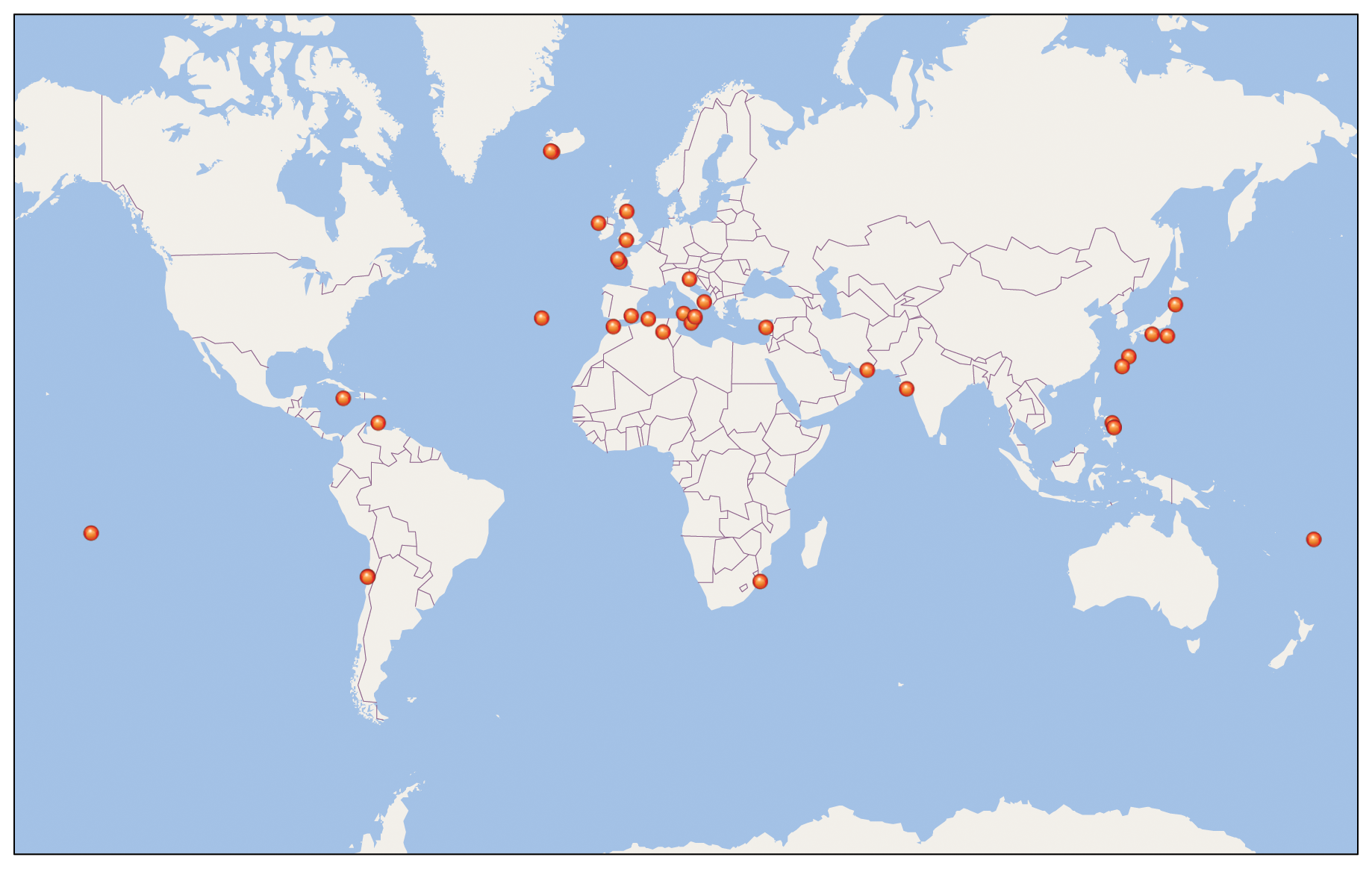
Figure 3Locations of coastal boulder deposit datasets recorded in ISROC-DB V1p0 (Kennedy et al., 2025b).
ISROC-DB (V1p0: 2025a; Kennedy et al., 2025b) can be accessed at https://www.designsafe-ci.org/data/browser/public/designsafe.storage.published/PRJ-5756 (last access: 17 October 2025). To date, it includes data from 36 studies published between 2007 and 2023. Constituent datasets range from fewer than ten boulders to more than a thousand, covering sites in 23 countries worldwide (Fig. 3). In aggregate, ISROC-DB provides a cross-section of approaches by active coastal boulder deposit research groups (including about half the co-authors of this paper). ISROC-DB does not include the entirety of available coastal boulder deposit measurements, although it is expected to grow, as there is an open invitation to workers to submit their data (2025a; Kennedy et al., 2025b). But it provides a wide-ranging and representative overview of data collection approaches in coastal boulder deposit studies over the past two decades.
4.1 Site characteristics: setting the scene
Basic information about the site and the boulders under study is an important component of field information. A description of the location including bedrock geology, topography, surface roughness, and other distinguishing features should be provided, based on site observations, literature analysis, and/or existing maps.
Boulder lithology should be recorded. Especially for newly-created or recently moved boulders, sites of origin are important (if they can be determined). The study should distinguish between the original bedrock source and pre-transport location of an already-existing boulder when possible. For example, a boulder might fall from a cliff originally, but subsequently be moved against gravity along a shore platform (Cox et al., 2018b; May et al., 2015). Boulder transport direction is likewise important: where possible, workers should determine whether transport is uphill (against gravity), horizontal (i.e. lateral movement on a level or near-level surface), or with gravity (sliding seaward on a platform, or falling/rolling down a cliff or slope). The orientation of the long axis is an important characteristic in this context, as (in the case of elongate clasts) this will tend to be oriented perpendicular to the direction of transport (Imamura et al., 2008; Spiske and Bahlburg, 2011) and hence says something about flow direction. And care must be taken in designing the measurement campaign to avoid selection biases in data collection, as these can affect any statistical analysis of the data.
4.2 Local knowledge is valuable
People living near a study site, especially those who spend a lot of time near the coast (e.g. fishing, maintenance, etc.), may have eye-witness information about boulder movements or changes in boulder configurations. Large blocks attract the climbing community, who take photos of that are often posted to social media, and which may provide documentation of boulder locations at specific times (e.g. pre-storm locations of two very large transported boulders in Cox et al., 2018a were determined from photographs provided by climbers). As Booth (2016) shows in his analysis of the “Big Rock” in Bondi (Australia), scientific interpretations may sometimes conflict with local knowledge or memory. While physical measurements and transport models are critical for analysis, they are not infallible, and it is wise to consult local residents for oral history or photographs that may provide critical documentation. Scientific interpretations that may not fully resolve the “messy realities” of dynamic coastal environments. Reaching out to locals can also be a way to engage them as citizen scientists, making them aware of the importance of coastal boulder deposits, and motivating them to take photos that may be useful for longitudinal comparisons.
4.3 Boulder dimensions: how big?
Clast sizes are at the heart of almost every coastal boulder project, whether measured by hand with a tape or digitally via photogrammetry (whether via drone, phone, or other image capture technology). In most cases, dimensions are used to derive volume (usually as a precursor to determining boulder mass). It is unsurprising therefore that all 36 studies in ISROC-DB measured the three principal axes (longest, intermediate, and shortest, referred to as X, Y, Z or a, b, c) of their target boulders, and all also computed volumes. However, not all studes tabulated the data: four did not provide individual boulder measurements, and an additional three reported only a subset. A full inventory of boulder locations and sizes should be a fundamental component of published work (whether as a Supplement table, or in a separate digital archive).
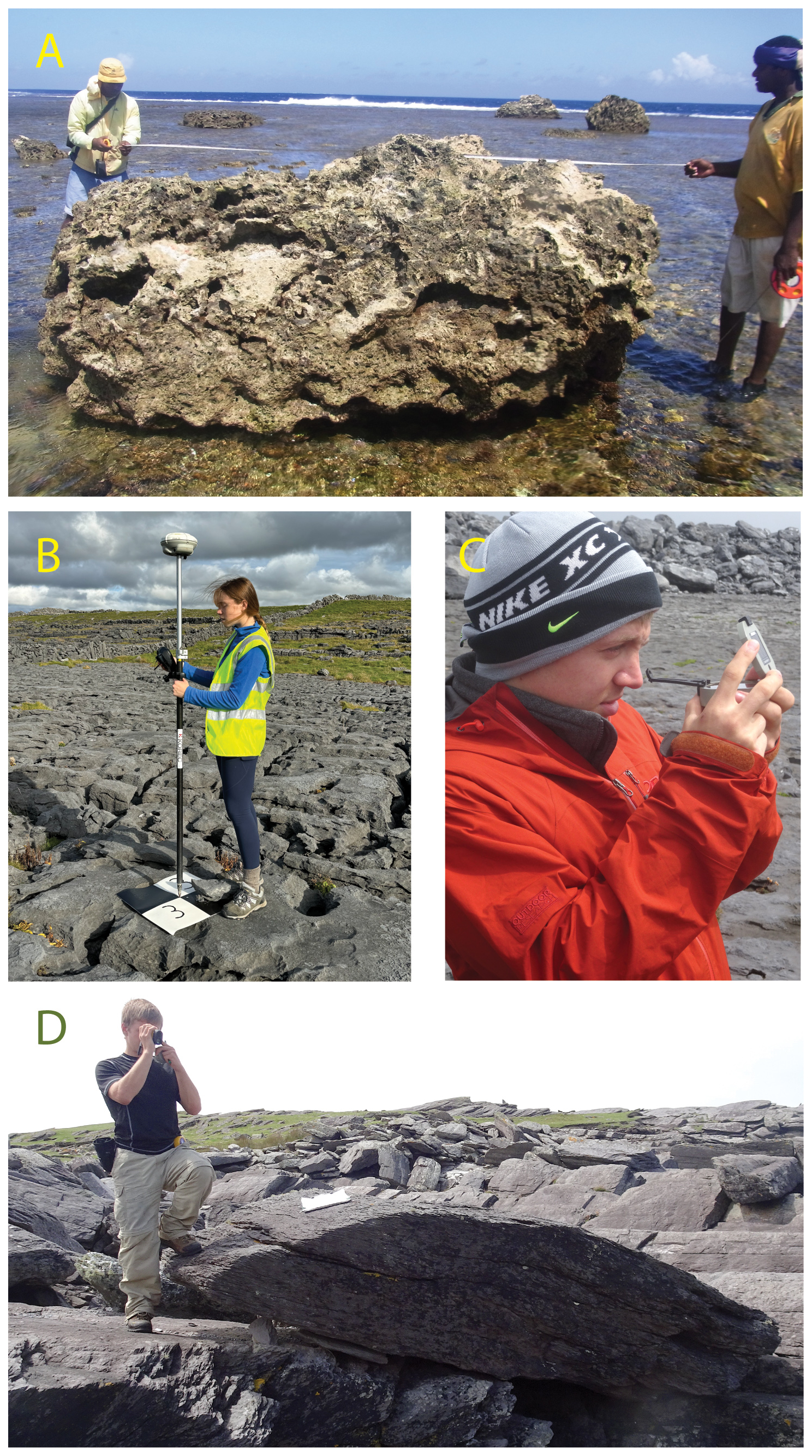
Figure 4Some field method techniques. (A) tape measurement of boulder axes; the irregularity of this boulder means that volume or mass estimates from tape dimensions are approximation only. (B) Siting a photogrammetric ground control point using RTK GPS. (C) Site surveying for elevation measurements using a transit compass (Brunton), which in combination with tape or laser rangefinder distance measurements can be used to derive vertical and/or horizontal distance using trigonometry. (D) measuring boulder distance from a shoreline marker using a laser rangefinder (Photo A by Annie Lau, B–D by Rónadh Cox,).
4.3.1 Axis measurements: harder than you think
Even in the current era of 3D imaging using drone-based structure-from-motion (SfM), and cell phones with LiDAR capability, simple linear measurement of the three principal axes remains the customary way of recording boulder dimensions. Hand-held tape measurements in the field are by far the most common (Fig. 4a), although the popularity of photogrammetric measurements is increasing (as shown by four of the 36 datasets in the database, all from studies published since 2019). Aerial maps of entire deposits provide a mechanism for collecting dimensions quite rapidly by measurement on either an orthoimage or 3D model. In some cases people have used a hybrid approach, measuring length and width (usually X and Y) from the aerial imagery and collecting height (usually Z) on the ground with a tape.
For rounded or tapered boulders, workers should take care to ensure that tapes are held taut so that they measure the straight line between end points. If they are draped across the boulder surface they will measure a partial circumference, which will be a longer distance than the desired axis. This can be prevented by projecting the boulder end points outward (using a clipboard or other straight rigid object), providing a measurement target for the tape. In many cases, especially with large boulders, this is a two-person operation.
Where boulders are not orthogonal, reporting the maximum axis lengths will result in misleading dimensions, and so some more representative intermediate or average value should be determined. It's even more complicated for highly irregular shapes such are common in reef environments or young carbonate rocks, where boulders may have pits, pinnacles, and non-rectilinear shapes (e.g. Fig. 4a). In these cases, axis measurements should be treated (and reported) as rough approximations only. If the boulders in question will be used to constrain transport hydrodynamics, photogrammetric models are strongly recommended.
4.3.2 Volume computations and their complexities
Axis dimensions are generally the basis for volume (and hence mass) determinations, which are the primary way of comparing among sites and events in terms of transport and depositional forces. Every study in ISROC-DB included volume calculations.
The approach (and the reliability of the result) will vary depending on boulder shape. For very regular boulders (e.g. from bedded sequences with orthogonal joint systems) the product of the three measured axes can provide reasonable first-order volume estimates (Cox et al., 2012). However, this is rarely the case, as most boulders have some degree of irregularity. The inaccuracy (overestimation) of volume based on triaxial measurements of non-geometric boulders is well documented, with errors exceeding 50 % or greater than 100 % in some cases (Boesl et al., 2020; Dunán-Avila et al., 2025; Engel and May, 2012; Hoffmeister et al., 2020; Lario et al., 2023; Yao et al., 2023). More irregular (but still fairly rectilinear) shapes require a more nuanced approach, and in some cases it may be appropriate to mentally subdivide the boulder into smaller components for which volumes are calculated separately and then summed. The volume of rounded boulders should be computed based on ellipsoidal geometry, where the product of the axes is multiplied by . For highly irregular boulders it is impossible to determine volume from triaxial measurements alone.
Photogrammetric analysis can cut through these difficulties. Reliable volumes can be obtained from high-resolution 3D models (see for example Canavesio et al., 2023; Dunán-Avila et al., 2025; Scardino et al., 2025), as long as the boulder is fully and carefully imaged. Coverage should include not only of top and sides, but also the base (particularly for irregular boulders with rough and karsted surfaces) to ensure that the final enclosed shape is fully representative. Proper scaling is also critical. Relying on built-in camera GPS positioning may result in decimetre or even metre-scale errors in model dimensions, and so image collection should include an object of known proportions that can be used to check and adjust the model (e.g. Causon Deguara and Gauci, 2017; Froideval et al., 2019; Gienko and Terry, 2014; Pedoja et al., 2023).
Only a few of the studies in ISROC-DB used 3D models to obtain boulder volumes; and of those most used it only for a few boulders, as a Supplement to simple axis data collected for the bulk of the clast population. This is not too surprising, because although photogrammetry is a reliable (and increasingly accessible) way to determine dimensions and derived properties of complex three-dimensional objects (Pedoja et al., 2023; Raoult et al., 2017; Yao et al., 2023), there are snags that often make it impractical for surveying large numbers of boulders. For example, it is generally difficult or impossible to image the lower surfaces of boulders or the sides of boulders in multi-boulder accumulations, which limits model accuracy.
In addition, volume computations require a closed (“watertight”) 3D model, necessitating interpolation across unimaged portions. This can be onerous, particularly in the case of very irregularly shaped boulders, or those with vegetation cover (Di Francesco et al., 2021; Nakata et al., 2023; Schneider et al., 2019). For example, if the software fails to properly interpolate across the open surface, some edges or mesh vertices may not connect properly, and the resulting mathematical inconsistencies may make the model difficult to process accurately: residual holes or gaps prevent creation of a watertight surface, leading to problems. Other pitfalls include inverted normals, where some surface elements face inward rather than outward and misrepresent the boulder's shape; or self-intersections, where parts of the model fold over themselves, generating unrealistic overlaps or non-manifold geometries. These, if internal to the model's outer surface, may go undetected and inflate volume estimates (Münster et al., 2024; Sulzer et al., 2025).
All of these problems are very solvable, but they do require hands-on manipulation of the model and can be time intensive. In contrast to axis measurements which, once collected in the field, can be loaded into a spreadsheet and put through batch calculations that rapidly process many hundreds of measurements, each digital boulder scan must be processed and/or checked individually. And although phone-based scanning software means that field collection of model data is quite rapid and straightforward, it still takes several times longer for image acquisition, model generation and on-site checking (to ensure that the boulder was adequately covered) than simply measuring boulder dimensions with a tape. Practitioners of digital volume calculations recommend integration alongside traditional field data collection techniques, not – at least at this stage – as a replacement (e.g. Boesl et al., 2020; Nakata et al., 2023; Spero et al., 2025).
Collecting a number of 3D boulder models will always enrich a coastal boulder deposit dataset. A suite of 3D models can provide validation and/or conversion factors for a larger set of field measurements of boulder dimensions, as well as a high-resolution data subset for the largest or otherwise most significant boulders in a dataset.
4.3.3 Estimating mass
Volume calculations are the basis for estimating boulder mass, which also requires rock density. Fourteen of the 36 studies in ISROC-DB reported a measured density; two used generalised values for the lithologies of interest, several gave a value but did not say where it had come from, and others provided mass estimates without indicating what density had been used.
To optimise mass estimates, we recommend that density measurements of the study boulders be included as part of the data collection and reporting. These are straightforward to acquire, needing only a small sample of the rock (or a few small samples so that the range of variability can be established). These are simply weighed, and volume measured by displacement in water, using Archimedes' principle (Corradino et al., 2025; Hoffmann et al., 2013; Hoffmeister et al., 2020). This is particularly important in the case of reef corals or young carbonate rock, which have high and non-uniform porosity, leading to variable bulk rock density values (Spiske et al., 2008).
4.4 Boulder locations
Long-term evolution of coastal boulder deposits will be key to an ultimate understanding of these dynamic environments, so locations of individual boulders are key data points. We found a range of practices relating to collection and reporting of positional data. Some studies provide general information (e.g. site name and/or coordinates), and in most cases a map or diagram showing boulder positions at the site. Others provide GPS coordinates for individual boulders. Whereas the former approach allows people to find the site, the latter method means that individual boulder information can be imported into GIS and other geospatial analytical systems, facilitating data compilation and meta-analysis. This is particularly important for longitudinal analysis, allowing repeat visits and the ability to track boulder movements (or stasis) over time. We therefore urge researchers to collect and report positional data for individual measured boulders.
Only two-thirds of the datasets in ISROC-DB (22 of 36) stated that they recorded GPS positions for individual measured boulders, and of those, just over half (12 of 22) tabulated those locations. There is a time component to these trends – only eight of 19 studies between 2007 and 2017 used GPS, compared with 14 of the 17 studies 2018–2023 – but of the 14 GPS-enabled studies in the more recent group, six (almost half) did not provide those data in the publication (either within the main text or in supplementary data). And although most of the non-reporting studies did show boulder positions on maps or orthoimages, in most cases those figures were too small to provide a useful source from which precise locations could be extracted, and boulder location markers were often overlapping at the scale of the diagrams. Nor could mapped locations be connected to specific boulder measurements. In sum: a large proportion of coastal boulder deposit studies either fail to collect or decline to report the positions of the rocks they measure. This limits the usability of published data for detailed longitudinal analysis of coastal boulder deposits.
How precise does location information need to be? Positions can be determined with centimetre-scale accuracy using Differential GPS (DGPS) or Real-Time Kinematic (RTK) GPS (Fig. 4b), and if available this is the most accurate way to map boulder placements (Andresen and Schultz-Fellenz, 2023; Hoffmeister, 2020). However, research groups may not have access to the necessary equipment and/or students may not be trained in its use; and it is important to bear in mind that such high precision is not always necessary. Data collected with hand-held GPS units can be perfectly adequate for purpose, especially those that support satellite-based signal augmentation systems such as WAAS (in the Americas), EGNOS (Europe), MSAS (Japan) (and similar systems for other regions). The 1–3 m positional accuracy such devices can achieve serve very well in mapping boulder locations, especially if combined with field photos that record boulder features and locational context. These can be sufficient for re-finding locations and determining whether or not individual boulders have been transported over time. Some researchers also use electronic tagging devices in highly dynamic locations to help locate transported boulders (Hastewell et al., 2019; Naylor et al., 2016).
Drone photogrammetry of entire locations produces high-precision mapping of deposits, as well as the possibility of quantitative reanalysis year-on-year (e.g. Autret et al., 2018; Nagle-McNaughton and Cox, 2020; Suanez et al., 2026; Vaccher et al., 2024; Yao et al., 2023), and is excellent for overall site characterisation. However, aerial imaging alone may not produce accurate 3D rendition of individual clasts, particularly if they are obscured or partially buried in ridges or clusters. Work that depends on characteristics of individual clasts should therefore include clast-specific positional data and measurements, which are best collected on the ground (or for very large boulders, with very low-altitude drone flights that target the individual boulder).
4.5 Horizontal distance
Most studies document how far individual boulders are from some marker, whether that is a shoreline, a cliff edge, or a reef front. In cases where the boulder is known to have moved, this may include a transportation distance. These measurements provide context on the separation between boulder location and the source of transportation energy, with longer distances generally representing more extreme wave events. Horizontal distance was included in 31 of the 36 datasets in ISROC-DB.
However, of those 31, twelve (more than a third) did not tabulate the data. Although some represented boulder locations on maps or orthophotos from which approximate positions could be extracted, this makes the data less accessible (requires manual extraction from the figure). Furthermore, the link between specific boulder measurements (axes, mass) and their distance inland is lost.
We recommend that workers tabulate distance values along with the boulder dimensions and positional data, for maximum long-term relevance and usability of the data. This can be done in GIS (horizontal distance between two points established using GPS, or measurement from aerial imagery), or it can be measured in the field using tapes or a laser rangefinder (Fig. 4d). These measurements are often not very precise, both because the baseline or datum may be hard to fix accurately (which will be discussed further below) or there may be variation in what part of the boulder (edge, centre of mass, etc.) is represented. The latter can introduce significant imprecision for large boulders and megagravel. However, high levels of precision are (in many cases) not necessary in the overall context of mapping boulder distributions: It would be valuable to know whether a boulder was 10 or 50 m form a baseline marker, but the difference between 10 and 12 m might not be significant (particularly when taking into account variations in water level due to tides, storm surge, infragravity waves, etc.). Therefore, recording those values (being careful to also report specifics of the methodology and associated precision) adds substantial value to coastal boulder datasets.
4.6 Elevation
Boulder elevation is a key attribute in datasets, because quantifying work done against gravity is fundamental for understanding hydrodynamics of dislodgement, transport and emplacement. However, it can be a difficult measurement to make, and often represents the greatest source of uncertainty and ambiguity in coastal boulder deposit studies. Of the 36 datasets in ISROC-DB, 15 (more than 40 %) provided no record of elevation for their measured boulders (some reported having made the measurement, but it did not appear in the tabulated data). Nine studies provided average elevations for suites of boulders, or had figures showing topographic profiles on which approximate boulder locations were shown; but only 11 (less than a third) tabulated elevation data along with boulder measurements. Recent papers were more likely than older ones to include elevation in their study design and reporting: almost half the studies published since 2018 included elevation data, compared with only a quarter of those published 2007–2017.
We recommend the routine collection of elevation in association with boulder measurements, to maximise their usefulness in terms of broad understanding of coastal boulder deposits. In some cases, elevation range may be very small (e.g. reef-flat boulders, or accumulations on very shallowly-sloping platforms or flat cliff tops) and a single surveyed value may appropriately represent the entire deposit. But for most deposits, elevation is variable and important.
Elevation can be a time-consuming measurement to make. Hand-held GPS is effectively useless, as the vertical accuracy is typically 2–3 times less than horizontal accuracy, producing elevation errors up to several tens of metres. DGPS or RTK GPS can solve the problem if available. Elevations can also be obtained from a Digital Surface Model (DSM) or topographic map, but it may be tedious and difficult to relate those elevations to field measurements for individual boulders. However, it is possible to measure elevation above some given marker using classical tape-and-compass or laser-rangefinder approaches (Coe, 2010; Łabuz, 2016) (Fig. 4c, d). If you can measure distance, and the angle from the horizontal, you can calculate the height difference using trigonometry (Cox et al., 2018b; Richmond et al., 2011); and if the marker is of known elevation, or is surveyed in, this can be translated to absolute elevation.
Accurate elevation data relative to a well-defined datum is essential for inter-site comparisons. We recommend using established local or national datum references where possible. Some countries publish the locations of geodetic reference points on open-access websites, which can be helpful for ensuring proper GPS calibration when available. However, these may be hard to find, or may be located distant from the field site. In such cases, local landmarks or ecological zonation may be surveyed in to provide a benchmark. Consistency in elevation measurement, including specifying datum and tidal conditions (as will be discussed further below), is necessary to avoid discrepancies.
Our analysis revealed that many studies neglect to report key geospatial information such as which geodetic system was used for positional information, the specifics of local sea-level for elevation and inland distance, and/or information about the local tide regime. Among the 36 ISROC-DB datasets, only three provided complete and clear descriptions of how baselines were established, which datums were used, and how those were locally determined and documented. We expect that other studies used careful procedures for setting the geospatial parameters of their measurements, but did not include the specifics in the published work. However, these details are not trivial in the context of broader data usability and longevity. Clear documentation of the frames of reference is a key aspect of geospatial data reporting to ensure usability, and minimising errors in both longitudinal analysis and inter-site comparison. We recommend that all studies carefully document the geodetic framework of their analysis, either in methods or as a Supplement.
5.1 For positional data, the geodetic reference system must be specified
GPS surveys provide positions calculated by the GPS receiver using a geodetic reference ellipsoid, which is a mathematically smoothed model of the Earth's shape that allows XY coordinates to be precisely located on the Earth's curved surface. However, there are a number of different ellipsoid models, and it is important to know and report the underlying reference system being used during data collection. There may be considerable error if location coordinates collected in one geodetic system are projected using another, without the requisite transformation. As one illustration of this, the US Global Positioning System satellites use WGS 84 as their underlying reference system for positional determinations, while the European Galileo satellite constellation uses ETRS89. Both were aligned in 1989, but ETRS89 is fixed to the stable Eurasian plate whereas WGS84 is referenced to the Earth's centre of mass. As a result, they have drifted due to plate tectonic motions at an average rate of 2.5 cm yr−1, meaning that currently there may almost a metre difference to be reconciled in converting one to the other (Baselga and Olsen, 2021; Twigg, 2000), and this dofference will increase as time goes on. Discrepancies with respect to other commonly used systems, such as NAD883 or local state planes, can be up to several meters.
Whereas GPS receivers and GIS programs can make those transformations easily, they require that users input the ellipsoid information; but this is commonly not provided in positional datasets. Many users do not interrogate the details that underpin the GPS data and therefore also do not report them, rendering their data ambiguous within the range of possible values for different models applied at that study site. Users should bear in mind that the information is given in the settings of GPS receivers, and included in metadata of downloaded readings. It is simply a matter of remembering to add that information into data tables and/or methods in manuscripts for publication.
5.2 Vertical and horizontal distance relative to what? The dastardly datum
Data collected with RTK or DGPS systems incorporate a geodetic datum that – as long as the reference system is known and incorporated into mapping transformations, as discussed above – provides reliable positional information. These can be international systems such as WGS84 or ETRS89 discussed above, or a national vertical datum can be applied (examples include the Australian Height Datum AHD, New Zealand Vertical Datum NZVD, Nivellement Général de la France IGN69, and many others).
But many studies use direct measurement to record elevation or inland distance. And at the coast this becomes a thorny problem, because we are usually interested in how positions relate to the shoreline, which is not a fixed marker. We found this to be the most poorly standardised measurement in published work. Among the 36 studies in ISROC-DB, there was tremendous inconsistency in handling the reference datum for elevation and/or distance.
Some workers tie measurements to a recognisable physical reference. The local high-water mark is one such indicator, used by several papers in our reference group. Of these, one used the high-water datum of the study area's national hydrographic service; others used visual determinations (e.g. height of barnacle encrustations, or rock discolouration due to splash-zone cyanobacteria). Another study used locally developed wave cut notches as the pinning point. These approaches provide a straightforward and repeatable pinning point for repeat studies in the same location (with due attention to potential changes due to rising sea level).
But the problem is that the bulk of studies provide only vague indications of what datum was used. Some, for example, say simply shoreline, or water's edge, with no reference to tidal variation (an important variable in its own right, which we will discuss more specifically below). Others mention mean sea level, without indication of how that was determined on site in the context of field measurements. And whereas microtidal environments might see only several cm vertical water change (which would have minimal influence on elevation measurements), that same tide range might cause a few metres horizontal change on a flat shore platform – which would have a substantial impact on measurements of inland distance.
Reporting clearly and in detail how the measurement datum was established in a study is important for comparisons: in trying to understand, for example, whether local coastal configuration affects the elevations at which different wave heights can act, it is important to be able to compare apples with apples, and know that boulders reported as e.g. 10 m elevation are all in fact at the same elevation. A boulder 10 m above water level at low tide may be only 5 m above high tide, or 7 m above mean sea level, and these differences matter, not only for site-to-site comparisons, but also for comparisons between different times at the same site.
5.3 Sea level: it's hard to measure
Important as it is to establish a local measurement datum, it can be very tricky to do. The most commonly invoked reference point is sea level, sometimes referred to as mean sea level, or given simply as “above sea level”. However, many studies neglect to specify what specific version of sea level was used, and/or how it was measured or recognized at the study location. This reflects the fundamental problem that “sea level” does not have a unique definition (Huang et al., 2020). And although centuries of water level measurements have produced precise definitions of tidal variations and mean sea levels(Gill and Schultz, 2001), on site these can be difficult to relate to boulder positions.
As examples of how this plays out in practice, seven studies in ISROC-DB referred simply to “sea level” and an additional two referred to the “shoreline”, with no details provided as to how those terms were defined for the study, and/or whether local tide variation had been factored in. In some cases terminology changed throughout the paper, with references to distance from shoreline in one part, and sea level in another. Another six referred to “mean sea level” or “MSL”, suggesting implementation of a global datum, but without providing the basis. In our set of 36 studies, only a handful provided clear information or related their datum to verifiable hydrographic surveys or markers.
However, as pointed out by Woodroffe and Barlow (2015), mean sea level provides no accumulations or proxies that would be evident on a map, which means that measurements need to be locally referenced to some local datum or indicator. But in very few cases did the writers indicate how they identified a fixed physical reference point in the field and/or in aerial imagery when making their measurements. The bottom line is that because the position of sea level is (literally) a moving target – not only because of tides, but because sea level itself varies across the geoid – it requires thought and proper documentation in field studies (Liu et al., 2014; Pajak and Leatherman, 2002; Parker, 2003; Woodroffe and Barlow, 2015).
5.4 The high-water mark: a useful workaround
Ecological markers provide a physical expression of the highest tide line, so it is feasible to make measurements relative to the barnacle line (for example), or the upper limit of the black cyanobacteria splash zone. Some places may have a distinct erosional feature such as a tidal notch that may function as a reference point (Antonioli et al., 2015; Evelpidou and Pirazzoli, 2015). However, these features all vary with bedrock locality, type and recent wave activity (Whittal and Mackie, 2023). On steeper coasts they commonly form a sharp line that is easy to identify; but on very shallowly-sloping platforms are likely to be much more diffuse and unlikely to provide a repeatable marker (Boak and Turner, 2005; Manno et al., 2017).
Although these physical reference frames can be very useful for repeatable local measurements, they lack generality, which means that comparisons with other areas may require assumptions about tide levels. And although they have the benefit of being reproducible in the short to medium term, they become less reliable on longer timescales in the context of sea level rise (or other shoreline-altering phenomena, including subsidence, tectonic processes and erosion).
5.5 Tides: an additional wrinkle
Tides are a further complication in trying to constrain sea level as a reference during field measurements. Some environments with small tides may see only slight changes (cm to 10s of cm), but tide range at many places is measured in metres, on both daily and neap-spring cycles. In such cases it is important to establish whether elevation and distance are given with respect to water level at the time of measurement (in which case the time and date should be given as part of the data), or whether they have been corrected for tide (in which case the correction calculation should be outlined, and the reference datum provided). This should include information about the tide gauge or tide tables that were used to establish tide information.
However, getting reliable local tide data is often difficult. Tide gauges are thinly spread in general; and because timing and magnitude are not uniform along coastlines, it is necessary to apply progressive extrapolations to peripheral sites. These are not always available in published tide tables, and in any event their reliability drops off with distance from the gauge (Egbert and Ray, 2017; Geyman and Maloof, 2020; Ray et al., 2011). As many coastal boulder deposits are remote from population centres and therefore may not have nearby gauges, this can be a substantial problem, undermining our ability to accurately know either the timing or magnitude of local tides.
Ocean tide models derived from satellite altimetry data may be applied, although their precision and accuracy vary based on location and model choice. Satellite data typically provide coarser spatial resolution than tide gauge data, which can make predictions less accurate at localised scale. Shallow-water effects can further reduce the accuracy of models in representing the interaction of tides with local bathymetry and shoreline features (Hart-Davis et al., 2024; Madsen et al., 2015; Nehama et al., 2022; Salameh et al., 2018). In addition, these products are not yet at the “plug-and-play” development stage, and require considerable expertise to implement at site-specific scale.
A more tractable approach can be to purchase off-the-shelf equipment to deploy on site (Bresnahan et al., 2023; Knight et al., 2021). This can be a useful strategy, particularly in areas targeted for repeat monitoring over multiple seasons or years. The locally-collected data can also be used longer term to calibrate or correct records from the closest permanent reference tide gauge (e.g. Dodet et al., 2018; Earlie et al., 2018; Hatcher et al., 2022).
5.6 And of course: sea level changes over time
Although this discussion is framed largely in the context of coastal boulder deposits in equilibrium with modern sea level, some accumulations were deposited thousands or even hundreds of thousands of years in the past (e.g. Carballeira et al., 2022; Kennedy et al., 2007). Failing to account for sea level difference in these cases could lead to misinterpretation of depositional elevation and transport forces. This can be true even for relatively young deposits (a few thousand years old), for which sea level may have been lower or higher than present: post-glacial sea level patters are complex, and include mid-Holocene highstands in some areas (Chua et al., 2021; Creel et al., 2024; Khan et al., 2015; Leonard et al., 2018). For deposits dating to the last inter-glacial there is even greater uncertainty linking boulder elevation to sea level (Rovere et al., 2025). Furthermore, tectonics can alter the relative position of sea level and coasts over Holocene or longer timescales and so must also be considered where relevant (e.g. Carballeira et al., 2022).
In sum: the difficulties attending the definition and measurement of “sea level” should be acknowledged, and not glossed over in study design or reporting. The reference frame for measurements should be clearly described, whether that relies on a local physical indicator or the geoid model underpinning a GPS survey. Clear statements should also be made about local tide regime, and in cases where tidal range is sufficient to impact the repeatability of distance or elevation measurements, tidal stage and height should be reported (as closely as possible).
Determining emplacement age(s) of coastal boulder deposits, and (for ancient example) establishing chronological constraints on the landscape at the time of boulder displacement are very desirable goals. Such data permit construction of event chronologies, and by comparison with other archives such as wave climate or earthquake records, can help distinguish between storm and tsunami deposits. Furthermore, landscape palaeoreconstruction permits estimation of sea level and coastline position at the time of displacement, which is important for calculation of forces required for transport. But these tasks are difficult at best and in many cases (at the present time) impossible.
Some boulders with preserved calcareous marine epifauna or infauna may yield radiocarbon ages recording the death time of the organism (hence presumably the time at which the boulder was removed from a subtidal or intertidal location, depending on the organism). This has provided valuable insights into multi-centennial history of deposits in some locations (Boulton and Whitworth, 2017; Cox et al., 2012; e.g. Scheffers et al., 2010; Scicchitano et al., 2007; Shah-Hosseini et al., 2011), but can be used only in suitable lithologies (primarily carbonates), requires a sub- or intertidal origin for the boulders (whereas many coastal boulder deposits consist of clasts torn from supratidal platforms or cliff edges), and can be complicated if the local marine 14C reservoir age is not well constrained (Atwater et al., 2017; Heaton et al., 2023) or due to diagenetic effects and the incorporation of old carbon from the parent rock (Rixhon et al., 2018).
Several other geochronometers have also been applied to coastal boulder deposits, with mixed or limited results to date. Other radioisotopes (particularly Uranium series 230Th/U) have been applied to reef-derived coral boulders with some success (Araoka et al., 2010; Lau et al., 2016; Rixhon et al., 2018; Terry et al., 2016; Yu et al., 2012; Zhao et al., 2009), although the uncertainties can be substantial (Rixhon et al., 2018), and again there are lithologic limitations. Innovative application of viscous remanent magnetism (Sato et al., 2022) at present is beset with uncertainties. Lichenometry has been attempted in some locations (Hall et al., 2006; Oliveira et al., 2020c), and although it may produce useful results in areas that are well characterised (McCarthy, 2021), the range of variability in growth rates (seasonally, annually, and in different locations), as well as uncertainty in colonization rates on fresh surfaces, mean that this is an imprecise technique that is primarily useful for relative dating (Winchester, 2023). The application of surface exposure dating using cosmogenic nuclides (Rixhon et al., 2018) or optically stimulated luminescence (Brill et al., 2021) is in its infancy and still associated with large uncertainties.
Whereas it may not be possible to date deposits, we encourage workers to investigate possible geochronology options, and where possible to use more than one, to provide internal validation and error checking. This field is constantly evolving, and we anticipate that the ability to date deposits and/or paleosurfaces will improve rapidly.
Many studies generate 100s or even 1000s of measurements and cannot be reported as simple tables within manuscripts. They can be provided in supplemental tables, or may be uploaded to a repository that can be cited and linked in the paper. Tabulated data are simplest for ingesting into larger databases, but GIS shapefiles or KML files work too. There are several general-purpose data repositories (e.g. FigShare, or OpenAIRE's Zenodo) that are both free and open-access, as well as numerous options that may be either discipline or country specific (too numerous to list here). The ISROC-DB database used for this analysis network is a DesignSafe data archive specific to coastal boulder deposits (2025a; Kennedy et al., 2025b). Researchers wishing to submit data for future updates to ISROC-DB can send an email to isroc.network@gmail.com. Making full datasets available online helps ensure long-term usability and relevance of the study. Whichever is chosen, the location and access information should be included with the published paper.
Individual studies of coastal boulder deposits may have a range of objectives, whether characterising deposit geomorphology and sedimentology (Bishop and Hughes, 1989; Cox et al., 2018a; Goto et al., 2012; Lau et al., 2014; Lau and Autret, 2020); documenting changes in response to events (Autret et al., 2018; Goto et al., 2011; Kennedy et al., 2016; Nagle-McNaughton and Cox, 2020; Naylor et al., 2016); using boulder characteristics to deduce hydrodynamics (e.g. initiation of motion criteria and bore velocity) (Nott, 2003b; Pepe et al., 2018; Shah-Hosseini et al., 2016), and attempting to determine whether the emplacing forces were from storm waves or tsunami (Biolchi et al., 2019a; Causon Deguara and Gauci, 2017; Switzer and Burston, 2010). The cited studies are examples, and of course most studies have multiple aims. All however share the fundamental goal of trying to better understand coastal boulder deposits overall, whether in the local context or more broadly. Therefore, data collected by one set of researchers may also be valuable to others making comparative analyses – or to the same research group coming back to sites later in time.
Coastal geomorphology research may inform critical decisions on climate change, natural resource management and hazard mitigation. Thus, standardised methodologies are essential for consistent, high-quality datasets that can be confidently interpreted and applied across regions and disciplines. Reliable comparisons allow researchers to generalize findings on wave energy, boulder transport mechanisms, and deposit persistence. This knowledge informs models predicting future storm impacts and supports coastal defence planning, which may integrate coastal boulder deposits insights into structural design (Cox and Pakrashi, 2023).
Although our discussion is specific to coastal boulder deposits, many of the methods and approaches that we describe would be best practices for studies of other kinds of coastal sites, including shore platforms, cliffs, and other energetic and geomorphologically dynamic environments.
8.1 Good data collection does not necessarily require expensive equipment
Tools such as drone photogrammetry and laser rangefinders are increasingly common and can certainly simplify field work, but we are keenly aware that such equipment is not available to all researchers. We want to ensure that the recommended best practices do not erect barriers to participation in the coastal boulder deposit community. Classical, low-tech field methods are very valuable, offering high precision, and for many applications are just as good as electronic or digital options.
By the same token, workers should bear in mind that whereas ultra-high-precision measurements may be necessary for some applications (e.g. measuring fine-scale platform erosion: Cullen and Bourke, 2018), in other instances they may exceed the requirements of the questions being asked, as discussed above. The stochastic nature of coastal systems makes many measurements inherently approximate, and high precision data readouts may give a false sense of accuracy in the context of the messy real world. For example, given the non-linearity of wave behaviour, and the numerous factors that influence bore velocity or initiation of boulder motion, it is usually sufficient to know boulder masses to within ∼10 %, and topographic dimensions to the nearest half-metre or so.
8.2 “Future-proofing” the data is important
The coastal research community is diverse, including geologists, geomorphologists, engineers, applied mathematicians, and wave physicists (among others), with a wide range of different backgrounds. Storm inundation and wave modelers need and want the kind of data that field geoscientists can provide. Civil engineers may be interested in coastal boulders as riprap or seawall analogues, and a kind of natural experiment in wave-infrastructure interactions as they simulate real-world wave-structure interactions, informing designs for riprap and seawalls (Cox and Pakrashi, 2023). Communities and schools may want to incorporate data into projects, or to use them in environmental planning. So in collecting data, we urge coastal boulder deposit researchers to remember the range of ways in which it is likely to be used, and make the information as usable as possible.
Data used for this analysis are from the Global Database for Coastal Boulder Deposits (ISROC-DB) from Inundation Signature on Rocky Coastlines (ISROC), available from the NSF NHERI DesignSafe archive (Kennedy et al., 2025b; https://doi.org/10.17603/ds2-nm6q-h553).
The supplement related to this article is available online at https://doi.org/10.5194/nhess-25-4203-2025-supplement.
Sections of this paper were drafted by participants in an ISROC-sponsored workshop on Field Methods and Standards (9 May 2022), and those participants are the co-authors of this submission. RC compiled the draft sections and produced the complete draft manuscript. Significant edits and revisions were provided by MCB, ME, ABK, AL, SS, with supporting critical review from SJB, MAO, RP, SR, DS, MS, WS, AS.
The contact author has declared that none of the authors has any competing interests.
Publisher’s note: Copernicus Publications remains neutral with regard to jurisdictional claims made in the text, published maps, institutional affiliations, or any other geographical representation in this paper. While Copernicus Publications makes every effort to include appropriate place names, the final responsibility lies with the authors. Views expressed in the text are those of the authors and do not necessarily reflect the views of the publisher.
This work was supported by National Science Foundation grant 2114016, and represents a contribution of the ISROC (Inundation Signatures on Rocky Coastlines) Research Coordination Network. It is also a contribution to IGCP Project 725: Forecasting Coastal Change. RC acknowledges support from National Science Foundation grants 1529756 and 1529756.
MAO acknowledges funding from Fundação para a Ciência e a Tecnologia (contract 2022.08411.CEECIND/CP1715/CT0005) and UIDB/00329/2020.
This research has been supported by the Directorate for Geosciences (grant no. 2114016).
This paper was edited by Mauricio Gonzalez and reviewed by Giovanni Scardino and one anonymous referee.
Abad, M., Izquierdo, T., Cáceres, M., Bernárdez, E., and Rodriguez-Vidal, J.: Coastal boulder deposit as evidence of an ocean-wide prehistoric tsunami originated on the Atacama Desert coast (northern Chile), Sedimentology, 67, 1505–1528, https://doi.org/10.1111/sed.12570, 2020.
Andresen, C. G. and Schultz-Fellenz, E. S.: Change Detection Applications in the Earth Sciences Using UAS-Based Sensing: A Review and Future Opportunities, Drones, 7, 258, https://doi.org/10.3390/drones7040258, 2023.
Antonioli, F., Lo Presti, V., Rovere, A., Ferranti, L., Anzidei, M., Furlani, S., Mastronuzzi, G., Orru, P. E., Scicchitano, G., Sannino, G., Spampinato, C. R., Pagliarulo, R., Deiana, G., de Sabata, E., Sansò, P., Vacchi, M., and Vecchio, A.: Tidal notches in Mediterranean Sea: a comprehensive analysis, Quaternary Science Reviews, 119, 66–84, https://doi.org/10.1016/j.quascirev.2015.03.016, 2015.
Araoka, D., Inoue, M., Suzuki, A., Yokoyama, Y., Edwards, R. L., Cheng, H., Matsuzaki, H., Kan, H., Shikazono, N., and Kawahata, H.: Historic 1771 Meiwa tsunami confirmed by high-resolution U/Th dating of massive Porites coral boulders at Ishigaki Island in the Ryukyus, Japan, Geochemistry, Geophysics, Geosystems, 11, https://doi.org/10.1029/2009GC002893, 2010.
Atwater, B. F., ten Brink, U. S., Cescon, A. L., Feuillet, N., Fuentes, Z., Halley, R. B., Nuñez, C., Reinhardt, E. G., Roger, J., Sawai, Y., Spiske, M., Tuttle, M. P., Wei, Y., and Weil-Accardo, J.: Geologic evidence for catastrophic marine inundation in 1200–1480 C.E. near the Puerto Rico Trench at Anegada, British Virgin Islands, Geosphere, 13, 301–368, https://doi.org/10.1130/GES01356.1, 2017.
Autret, R., Dodet, G., Fichaut, B., Suanez, S., David, L., Leckler, F., Ardhuin, F., Ammann, J., Grandjean, P., Allemand, P., and Filipot, J.-F.: A comprehensive hydro-geomorphic study of cliff-top storm deposits on Banneg Island during winter 2013–2014, Marine Geology, 382, 37–55, https://doi.org/10.1016/j.margeo.2016.09.014, 2016.
Autret, R., Dodet, G., Suanez, S., Roudaut, G., and Fichaut, B.: Long–term variability of supratidal coastal boulder activation in Brittany (France), Geomorphology, 304, 184–200, https://doi.org/10.1016/j.geomorph.2017.12.028, 2018.
Autret, R., Didier, D., Suanez, S., Stéphan, P., Ammann, J., Baudry, J., Erlingsson, B., and Sigurðarson, S.: Cliff-top boulder morphodynamics on the high–energy volcanic rocky coast of the Reykjanes Peninsula (SW Iceland), Marine Geology, 456, 106984, https://doi.org/10.1016/j.margeo.2022.106984, 2023.
Bahlburg, H. and Spiske, M.: Styles of early diagenesis and the preservation potential of onshore tsunami deposits–A re-survey of Isla Mocha, Central Chile, 2years after the February 27, 2010, Maule tsunami, Sedimentary Geology, 326, 33–44, https://doi.org/10.1016/j.sedgeo.2015.06.009, 2015.
Barbano, M. S., Pirrotta, C., and Gerardi, F.: Large boulders along the south-eastern Ionian coast of Sicily: Storm or tsunami deposits?, Marine Geology, 275, 140–154, https://doi.org/10.1016/j.margeo.2010.05.005, 2010.
Baselga, S. and Olsen, M. J.: Approximations, Errors, and Misconceptions in the Use of Map Projections, Mathematical Problems in Engineering, 2021, 1094602, https://doi.org/10.1155/2021/1094602, 2021.
Benner, R., Browne, T., Brückner, H., Kelletat, D., and Scheffers, A.: Boulder transport by waves: progress in physical modelling, Zeitschrift für Geomorphologie, 54, 127–146, https://doi.org/10.1127/0372-8854/2010/0054S3-0022, 2010.
Biolchi, S., Furlani, S., Antonioli, F., Baldassini, N., Causon Deguara, J., Devoto, S., Di Stefano, A., Evans, J., Gambin, T., Gauci, R., Mastronuzzi, G., Monaco, C., and Scicchitano, G.: Boulder accumulations related to extreme wave events on the eastern coast of Malta, Nat. Hazards Earth Syst. Sci., 16, 737–756, https://doi.org/10.5194/nhess-16-737-2016, 2016.
Biolchi, S., Furlani, S., Devoto, S., Scicchitano, G., Korbar, T., Vilibić, I., and Šepić, J.: The origin and dynamics of coastal boulders in a semi-enclosed shallow basin: A northern Adriatic case study, Marine Geology, 411, 62–77, https://doi.org/10.1016/j.margeo.2019.01.008, 2019a.
Biolchi, S., Denamiel, C., Devoto, S., Korbar, T., Macovaz, V., Scicchitano, G., Vilibić, I., and Furlani, S.: Impact of the October 2018 Storm Vaia on Coastal Boulders in the Northern Adriatic Sea, Water, 11, 2229, https://doi.org/10.3390/w11112229, 2019b.
Bishop, P. and Hughes, M.: Imbricate and fitted fabrics in coastal boulder deposits on the Australian east coast, Geology, 17, 544–547, https://doi.org/10.1130/0091-7613(1989)017<0544:IAFFIC>2.3.CO;2, 1989.
Blair, T. C. and McPherson, J. G.: Grain-size and textural classification of coarse sedimentary particles, Journal of Sedimentary Research, 69, 6–19, 1999.
Boak, E. H. and Turner, I. L.: Shoreline Definition and Detection: A Review, Journal of Coastal Research, 2005, 688–703, 2005.
Boesl, F., Engel, M., Eco, R. C., Galang, J. B., Gonzalo, L. A., Llanes, F., Quix, E., and Brückner, H.: Digital mapping of coastal boulders – high-resolution data acquisition to infer past and recent transport dynamics, Sedimentology, 67, 1393–1410, https://doi.org/10.1111/sed.12578, 2020.
Booth, D.: Bondi's Big Rock: explanations and representations in coastal geomorphology, Geographical Research, 54, 357–364, https://doi.org/10.1111/1745-5871.12194, 2016.
Boulton, S. J. and Whitworth, M. R. Z.: Block and boulder accumulations on the southern coast of Crete (Greece): evidence for the 365 CE tsunami in the Eastern Mediterranean, Geological Society, London, Special Publications, 456, 105–125, 2017.
Bourgeois, J. and MacInnes, B.: Tsunami boulder transport and other dramatic effects of the 15 November 2006 central Kuril Islands tsunami on the island of Matua, Zeitschrift für Geomorphologie, 54, 175–195, https://doi.org/10.1127/0372-8854/2010/0054S3-0024, 2010.
Bourrouilh-Le Jan, F. G. and Talandier, J.: Sedimentation et fracturation de haute energie en milieu recifal: Tsunamis, ouragans et cyclones et leurs effets sur la sedimentologie et la geomorphologie d'un atoll: Motu et hoa, a rangiroa, Tuamotu, Pacifique SE, Marine Geology, 67, 263–333, https://doi.org/10.1016/0025-3227(85)90095-7, 1985.
Bresnahan, P., Briggs, E., Davis, B., Rodriguez, A. R., Edwards, L., Peach, C., Renner, N., Helling, H., and Merrifield, M.: A low-cost, DIY ultrasonic water level sensor for education, citizen science, and research, Oceanography, 36, 51–58, 2023.
Brill, D., May, S. M., Mhammdi, N., King, G., Lehmann, B., Burow, C., Wolf, D., Zander, A., and Brückner, H.: Evaluating optically stimulated luminescence rock surface exposure dating as a novel approach for reconstructing coastal boulder movement on decadal to centennial timescales, Earth Surf. Dynam., 9, 205–234, https://doi.org/10.5194/esurf-9-205-2021, 2021.
Bryant, E. A. and Nott, J.: Geological Indicators of Large Tsunami in Australia, Natural Hazards, 24, 231–249, https://doi.org/10.1023/A:1012034021063, 2001.
Bujan, N. and Cox, R.: Maximal Heights of Nearshore Storm Waves and Resultant Onshore Flow Velocities, Frontiers in Marine Science, 7, https://doi.org/10.3389/fmars.2020.00309, 2020.
Canavesio, R., Cohen, O., Pons-Branchu, E., and Costa, S.: Atoll islets reshaping processes induced by extreme cyclonic waves and calm weather. Evidence from two centuries of megablocks emergences and coral rubble displacements in Anaa, Rangiroa and Tikehau atolls (western Tuamotu archipelago – French Polynesia), Marine Geology, 464, 107140, https://doi.org/10.1016/j.margeo.2023.107140, 2023.
Carballeira, R., Peña-Monne, J. L., Otero, X. L., Sampietro-Vattuone, M. M., Castro-Correa, C. P., Soto-Bauerle, M. V., and Pérez-Alberti, A.: Paleotsunami evidence in the Bahía Inglesa coast (Atacama, Chile) based on a multi-approach analysis, Environmental Earth Sciences, 81, 153, https://doi.org/10.1007/s12665-022-10259-2, 2022.
Causon Deguara, J. and Gauci, R.: Evidence of extreme wave events from boulder deposits on the south-east coast of Malta (Central Mediterranean), Natural Hazards, 86, 543–568, https://doi.org/10.1007/s11069-016-2525-4, 2017.
Chua, S., Switzer, A. D., Li, T., Chen, H., Christie, M., Shaw, T. A., Khan, N. S., Bird, M. I., and Horton, B. P.: A new Holocene sea-level record for Singapore, The Holocene, 31, 1376–1390, https://doi.org/10.1177/09596836211019096, 2021.
Coe, A. L.: Geological field techniques, John Wiley & Sons, 323 pp., ISBN 978-1-444-33062-5, 2010.
Corradino, M., Faraci, C., Monaco, C., and Pepe, F.: Coastal boulder production controlled by columnar joints of ignimbrite and extreme waves: insights from the high-energy coast of Pantelleria Island (Sicily Channel, Mediterranean Sea), Natural Hazards, 121, 3621–3655, https://doi.org/10.1007/s11069-024-06936-z, 2025.
Costa, P. J. M. and Andrade, C.: Tsunami deposits: Present knowledge and future challenges, Sedimentology, 67, 1189–1206, https://doi.org/10.1111/sed.12724, 2020.
Cox, R. and Pakrashi, V.: Field Studies of Megagravel Transport: Relevance for Coastal Infrastructure Engineering, ce/papers, 6, 768–771, https://doi.org/10.1002/cepa.2211, 2023.
Cox, R., Zentner, D. B., Kirchner, B. J., and Cook, M. S.: Boulder ridges on the Aran Islands (Ireland): Recent movements caused by storm waves, not tsunami, Journal of Geology, 120, 249–272, https://doi.org/10.1086/664787, 2012.
Cox, R., Lopes, W. A., and Jahn, K. L.: Quantitative roundness analysis of coastal boulder deposits, Marine Geology, 396, 114–141, https://doi.org/10.1016/j.margeo.2017.03.003, 2018a.
Cox, R., Jahn, K. L., Watkins, O. G., and Cox, P.: Extraordinary boulder transport by storm waves (west of Ireland, winter 2013–2014), and criteria for analysing coastal boulder deposits, Earth-Science Reviews, 177, 623–636, https://doi.org/10.1016/j.earscirev.2017.12.014, 2018b.
Cox, R., Ardhuin, F., Dias, F., Autret, R., Beisiegel, N., Earlie, C. S., Herterich, J. G., Kennedy, A. B., Raby, A., Schmitt, P., and Weiss, R.: Systematic review shows that work done by storm waves can be mistinterpreted as tsunami-related, because commonly used hydrodynamic equations are flawed, Frontiers in Marine Science, https://doi.org/10.3389/fmars.2020.00004 2020.
Creel, R. C., Austermann, J., Kopp, R. E., Khan, N. S., Albrecht, T., and Kingslake, J.: Global mean sea level likely higher than present during the holocene, Nature Communications, 15, 10731, https://doi.org/10.1038/s41467-024-54535-0, 2024.
Cullen, N. D. and Bourke, M. C.: Clast abrasion of a rock shore platform on the Atlantic coast of Ireland, Earth Surface Processes and Landforms, 43, 2627–2641, https://doi.org/10.1002/esp.4421, 2018.
Di Francesco, P.-M., Bonneau, D. A., and Hutchinson, D. J.: Computational Geometry-Based Surface Reconstruction for Volume Estimation: A Case Study on Magnitude-Frequency Relations for a LiDAR-Derived Rockfall Inventory, ISPRS International Journal of Geo-Information, 10, 157, 2021.
Dodet, G., Leckler, F., Sous, D., Ardhuin, F., Filipot, J. F., and Suanez, S.: Wave runup over steep rocky cliffs, Journal of Geophysical Research: Oceans, 123, 7185–7205, https://doi.org/10.1029/2018JC013967, 2018.
Dunán-Avila, P., Authemayou, C., Jaud, M., Pedoja, K., Jara-Muñoz, J., Bertin, S., Peñalver-Hernández, L., Floc'h, F., Nuñez-Labañino, A., Winckler, P., Pierre-Toledo, J., Benítez-Frometa, P., Ross-Cabrera, H., Letortu, P., Rodríguez-Valdés, A. R., Coutín-Lobaina, N., and Chauveau, D.: Geomorphological signatures of known hurricanes and validation of theoretical emplacement formulations: Coastal boulder deposits on Cuban low-lying marine terraces, Marine Geology, 480, 107438, https://doi.org/10.1016/j.margeo.2024.107438, 2025.
Earlie, C., Masselink, G., and Russell, P.: The role of beach morphology on coastal cliff erosion under extreme waves, Earth Surface Processes and Landforms, 43, 1213–1228, https://doi.org/10.1002/esp.4308, 2018.
Egbert, G. D. and Ray, R. D.: Tidal prediction, Journal of Marine Research, 75, 189–237, https://elischolar.library.yale.edu/journal_of_marine_research/432 (last access: 24 October 2024), 2017.
Engel, M. and May, S. M.: Bonaire's boulder fields revisited: evidence for Holocene tsunami impact on the Leeward Antilles, Quaternary Science Reviews, 54, 126–141, https://doi.org/10.1016/j.quascirev.2011.12.011, 2012.
Engel, M., Oetjen, J., May, S. M., and Brückner, H.: Tsunami deposits of the Caribbean – Towards an improved coastal hazard assessment, Earth-Science Reviews, 163, 260–296, https://doi.org/10.1016/j.earscirev.2016.10.010, 2016.
Etienne, S. and Paris, R.: Boulder accumulations related to storms on the south coast of the Reykjanes Peninsula (Iceland), Geomorphology, 114, 55–70, https://doi.org/10.1016/j.geomorph.2009.02.008, 2010.
Etienne, S., Buckley, M., Paris, R., Nadesna, A. K., Clark, K., Strotz, L., Chagué-Goff, C., Goff, J., and Richmond, B. M.: The use of boulders for characterising past tsunamis: Lessons from the 2004 Indian Ocean and 2009 South Pacific tsunamis, Earth Science Reviews, 107, 76–90, https://doi.org/10.1016/j.earscirev.2010.12.006, 2011.
Evelpidou, N. and Pirazzoli, P. A.: Sea-Level Indicators, in: Environmental Management and Governance: Advances in Coastal and Marine Resources, edited by: Finkl, C. W. and Makowski, C., Springer International Publishing, Cham, 291–311, https://doi.org/10.1007/978-3-319-06305-8_12, 2015.
Evelpidou, N., Zerefos, C., Synolakis, C., Repapis, C., Karkani, A., Polidorou, M., and Saitis, G.: Coastal Boulders on the SE Coasts of Cyprus as Evidence of Palaeo-Tsunami Events, Journal of Marine Science and Engineering, 8, 812, 2020.
Fichaut, B. and Suanez, S.: Quarrying, transport and deposition of cliff-top storm deposits during extreme events: Banneg Island, Brittany, Marine Geology, 283, 36–55, https://doi.org/10.1016/j.margeo.2010.11.003, 2011.
Frohlich, C., Hornbach, M. J., Taylor, F. W., Shen, C.-C., Moala, A., Morton, A. E., and Kruger, J.: Huge erratic boulders in Tonga deposited by a prehistoric tsunami, Geology, 37, 131–134, https://doi.org/10.1130/g25277a.1, 2009.
Froideval, L., Pedoja, K., Garestier, F., Moulon, P., Conessa, C., Pellerin Le Bas, X., Traoré, K., and Benoit, L.: A low-cost open-source workflow to generate georeferenced 3D SfM photogrammetric models of rocky outcrops, The Photogrammetric Record, 34, 365–384, https://doi.org/10.1111/phor.12297, 2019.
Geyman, E. C. and Maloof, A. C.: Deriving Tidal Structure From Satellite Image Time Series, Earth and Space Science, 7, e2019EA000958, https://doi.org/10.1029/2019EA000958, 2020.
Gienko, G. A. and Terry, J. P.: Three-dimensional modeling of coastal boulders using multi-view image measurements, Earth Surface Processes and Landforms, 39, 853–864, https://doi.org/10.1002/esp.3485, 2014.
Gill, S. K. and Schultz, J. R. (Eds.): Tidal datums and their applications, NOAA special publication NOS CO-OPS 1, 132 pp., https://repository.library.noaa.gov/view/noaa/50574 (last access: 17 October 2025), 2001.
Goff, J., Dudley, W. C., deMaintenon, M. J., Cain, G., and Coney, J. P.: The largest local tsunami in 20th century Hawaii, Marine Geology, 226, 65–79, https://doi.org/10.1016/j.margeo.2005.09.017, 2006.
Goto, K., Chavanich, S. A., Imamura, F., Kunthasap, P., Matsui, T., Minoura, K., Sygawara, D., and Yanagisawa, H.: Distribution, origin and transport process of boulders deposited by the 2004 Indian Ocean tsunami at Parakang Cape, Thailand, Sedimentary Geology, 202, 821–837, https://doi.org/10.1016/j.sedgeo.2007.09.004, 2007.
Goto, K., Okada, K., and Imamura, F.: Characteristics and hydrodynamics of boulders transported by storm waves at Kudaka Island, Japan, Marine Geology, 262, 14–24, https://doi.org/10.1016/j.margeo.2009.03.001, 2009.
Goto, K., Miyagi, K., Kawamata, H., and Imamura, F.: Disrimination of boulders deposited by tsunamis and storm waves at Ishigaki Island, Japan, Marine Geology, 269, 34–45, https://doi.org/10.1016/j.margeo.2009.12.004, 2010a.
Goto, K., Shinozaki, T., Minoura, K., Okada, K., Sugawara, D., and Imamura, F.: Distribution of boulders at Miyara Bay of Ishigaki Island, Japan: A flow characteristic indicator of tsunami and storm waves, Island Arc, 19, 412–426, https://doi.org/10.1111/j.1440-1738.2010.00721.x, 2010b.
Goto, K., Miyagi, K., Kanawa, T., Takahashi, J., and Imamura, F.: Emplacement and movement of boulders by known storm waves – Field evidence from the Okinawa Islands, Japan, Marine Geology, 283, 66–78, https://doi.org/10.1016/j.margeo.2010.09.007, 2011.
Goto, K., Sugawara, D., Ikema, S., and Miyagi, T.: Sedimentary processes associated with sand and boulder deposits formed by the 2011 Tohoku-oki tsunami at Sabusawa Island, Japan, Sedimentary Geology, 282, 188–198, https://doi.org/10.1016/j.sedgeo.2012.03.017, 2012.
Gusiakov, V. K.: Meteotsunamis at global scale: problems of event identification, parameterization and cataloguing, Natural Hazards, 106, 1105–1123, https://doi.org/10.1007/s11069-020-04230-2, 2021.
Hall, A. M., Hansom, J. D., Williams, D. M., and Jarvis, J.: Distribution, geomorphology and lithofacies of cliff-top storm deposits: Examples from the high-energy coasts of Scotland and Ireland, Marine Geology, 232, 131–155, https://doi.org/10.1016/j.margeo.2006.06.008, 2006.
Hansom, J. D., Barltrop, N. D. P., and Hall, A. M.: Modelling the processes of cliff-top erosion and deposition under extreme storm waves, Marine Geology, 253, 36–50, https://doi.org/10.1016/j.margeo.2008.02.015, 2008.
Hansom, J. D., Switzer, A. D., and Pile, J.: Extreme Waves: Causes, Characteristics, and Impact on Coastal Environments and Society, in: Coastal and Marine Hazards, Risks, and Disasters, edited by: Shroder, J. F., Ellis, J. T., and Sherman, D. J., Elsevier, Boston, 307–334, https://doi.org/10.1016/B978-0-12-396483-0.00011-X, 2015.
Hart-Davis, M. G., Andersen, O. B., Ray, R. D., Zaron, E. D., Schwatke, C., Arildsen, R. L., Dettmering, D., and Nielsen, K.: Tides in Complex Coastal Regions: Early Case Studies From Wide-Swath SWOT Measurements, Geophysical Research Letters, 51, e2024GL109983, https://doi.org/10.1029/2024GL109983, 2024.
Hastewell, L. J., Schaefer, M., Bray, M., and Inkpen, R.: Intertidal boulder transport: A proposed methodology adopting Radio Frequency Identification (RFID) technology to quantify storm induced boulder mobility, Earth Surface Processes and Landforms, 44, 681–698, https://doi.org/10.1002/esp.4523, 2019.
Hatcher, S. V., Forbes, D. L., and Manson, G. K.: Boulder-strewn flats in a high-latitude macrotidal embayment, Baffin Island: geomorphology, formation, and future stability, Canadian Journal of Earth Sciences, 59, 866–883, https://doi.org/10.1139/cjes-2021-0019, 2022.
Heaton, T. J., Bard, E., Bronk Ramsey, C., Butzin, M., Hatté, C., Hughen, K. A., Köhler, P., and Reimer, P. J.: A response to community questions on the Marine20 radiocarbon age calibration curve: Marine reservoir ages and the calibration of 14C samples from the oceans, Radiocarbon, 65, 247–273, https://doi.org/10.1017/RDC.2022.66, 2023.
Hoffmann, G., Reicherter, K., Wiatr, T., Grützner, C., and Rausch, T.: Block and boulder accumulations along the coastline between Fins and Sur (Sultanate of Oman): tsunamigenic remains?, Natural Hazards 65, 851–873, https://doi.org/10.1007/s11069-012-0399-7, 2013.
Hoffmeister, D.: Mapping of subaerial coarse clasts, in: Geological Records of Tsunamis and Other Extreme Waves, edited by: Engel, M., Pilarczyk, J., May, S. M., Brill, D., and Garrett, E., Elsevier, 169–184, https://doi.org/10.1016/B978-0-12-815686-5.00009-2, 2020.
Hoffmeister, D., Curdt, C., and Bareth, G.: Monitoring the sedimentary budget and dislocated boulders in western Greece – results since 2008, Sedimentology, 67, 1411–1430, https://doi.org/10.1111/sed.12723, 2020.
Huang, C., Zhang, H., and Zhao, J.: High-Efficiency Determination of Coastline by Combination of Tidal Level and Coastal Zone DEM from UAV Tilt Photogrammetry, Remote Sensing, 12, 2189, https://doi.org/10.3390/rs12142189, 2020.
Imamura, F., Goto, K., and Ohkobo, S.: A numerical model for the transport of a boulder by tsunami, Journal of Geophysical Research, 113, https://doi.org/10.1029/2007JC004170, 2008.
Jones, B. and Hunter, I. G.: Very Large Boulders on the Coast of Grand Cayman: The Effects of Giant Waves on Rocky Coastlines, Journal of Coastal Research, 8, 763–774, 1992.
Kato, Y. and Kimura, M.: Age and origin of so-called ”Tsunami-ishi” Ishigaki Island, Okinawa Prefecture, Journal of the Geological Society of Japan, 89, 471–474, https://doi.org/10.5575/geosoc.89.471, 1983.
Kelletat, D., Engel, M., May, S. M., Erdmann, W., Scheffers, A., and Brückner, H.: Erosive impact of tsunami and storm waves on rocky coasts and post-depositional weathering of coarse-clast deposits, in: Geological Records of Tsunamis and Other Extreme Waves, edited by: Engel, M., Pilarczyk, J., May, S. M., Brill, D., and Garrett, E., Elsevier, 561–584, https://doi.org/10.1016/B978-0-12-815686-5.00026-2, 2020.
Kennedy, A., Cox, R., Engel, M., Spreyer, E., Lau, A. Y. A., and Mori, N.: The Inundation Signatures on Rocky Coastlines Global Database for Coastal Boulder Deposits (ISROC-DB), Marine Geology, 487, https://doi.org/10.1016/j.margeo.2025.107581, 2025a.
Kennedy, A., Cox, R., Engel, M., Speyrer, E., Lau, A., Mori, N., and Berke, M.: The Global Database for Coastal Boulder Deposits (ISROC-DB) from Inundation Signature on Rocky Coastlines (ISROC), DesignSafe PRJ-5756 [data set], https://doi.org/10.17603/ds2-nm6q-h553, 2025b.
Kennedy, A. B., Mori, N., Zhang, Y., Yasuda, T., Chen, S.-E., Tajima, Y., Pecor, W., and Toride, K.: Observations and Modeling of Coastal Boulder Transport and Loading During Super Typhoon Haiyan, Coastal Engineering Journal, 58, 1640004-1–1640004-25, https://doi.org/10.1142/s0578563416400040, 2016.
Kennedy, A. B., Mori, N., Yasuda, T., Shimozono, T., Tomiczek, T., Donahue, A., Shimura, T., and Imai, Y.: Extreme block and boulder transport along a cliffed coastline (Calicoan Island, Philippines) during Super Typhoon Haiyan, Marine Geology, 383, 65–77, https://doi.org/10.1016/j.margeo.2016.11.004, 2017.
Kennedy, A. B., Cox, R., and Dias, F.: Storm Waves May Be the Source of Some “Tsunami” Coastal Boulder Deposits, Geophysical Research Letters, 48, e2020GL090775, https://doi.org/10.1029/2020GL090775, 2021.
Kennedy, D. M., Tannock, K. L., Crozier, M. J., and Rieser, U.: Boulders of MIS 5 age deposited by a tsunami on the coast of Otago, New Zealand, Sedimentary Geology, 200, 222–231, https://doi.org/10.1016/j.sedgeo.2007.01.005, 2007.
Khan, N. S., Ashe, E., Shaw, T. A., Vacchi, M., Walker, J., Peltier, W. R., Kopp, R. E., and Horton, B. P.: Holocene Relative Sea-Level Changes from Near-, Intermediate-, and Far-Field Locations, Current Climate Change Reports, 1, 247–262, https://doi.org/10.1007/s40641-015-0029-z, 2015.
Knight, P., Bird, C., Sinclair, A., Higham, J., and Plater, A.: Testing an “IoT” Tide Gauge Network for Coastal Monitoring, IoT, 2, 17–32, 2021.
Łabuz, T. A.: A review of field methods to survey coastal dunes–experience based on research from South Baltic coast, Journal of Coastal Conservation, 20, 175–190, https://doi.org/10.1007/s11852-016-0428-x, 2016.
Lario, J., Spencer, C., and Bardají, T.: Presence of boulders associated with an extreme wave event in the western Mediterranean (Cape Cope, Murcia, Spain): possible evidence of a tsunami, Journal of Iberian Geology, 49, 115–132, https://doi.org/10.1007/s41513-023-00208-8, 2023.
Lau, A. Y. A. and Autret, R.: Spatial patterns of subaerial coarse clasts, in: Geological Records of Tsunamis and Other Extreme Waves, edited by: Engel, M., Pilarczyk, J., May, S. M., Brill, D., and Garrett, E., Elsevier, 513–546, https://doi.org/10.1016/B978-0-12-815686-5.00024-9, 2020.
Lau, A. Y. A., Etienne, S., Terry, J. P., Switzer, A. D., and Lee, Y. S.: A preliminary study of the distribution, sizes and orientations of large reef-top coral boulders deposited by extreme waves at Makemo Atoll, French Polynesia, Journal of Coastal Research, 272–277, https://doi.org/10.2112/SI70-046.1, 2014.
Lau, A. Y. A., Terry, J. P., Ziegler, A. D., Switzer, A. D., Lee, Y., and Etienne, S.: Understanding the history of extreme wave events in the Tuamotu Archipelago of French Polynesia from large carbonate boulders on Makemo Atoll, with implications for future threats in the central South Pacific, Marine Geology, 380, 174–190, https://doi.org/10.1016/j.margeo.2016.04.018, 2016.
Lau, A. Y. A., Terry, J. P., Ziegler, A., Pratap, A., and Harris, D.: Boulder emplacement and remobilisation by cyclone and submarine landslide tsunami waves near Suva City, Fiji, Sedimentary Geology, 364, 242–257, https://doi.org/10.1016/j.sedgeo.2017.12.017, 2018.
Leonard, N. D., Welsh, K. J., Clark, T. R., Feng, Y. X., Pandolfi, J. M., and Zhao, J. X.: New evidence for “far-field” Holocene sea level oscillations and links to global climate records, Earth and Planetary Science Letters, 487, 67–73, https://doi.org/10.1016/j.epsl.2018.02.008, 2018.
Liu, X., Xia, J., Wright, G., and Arnold, L.: A state of the art review on High Water Mark (HWM) determination, Ocean & Coastal Management, 102, 178–190, https://doi.org/10.1016/j.ocecoaman.2014.09.027, 2014.
Lorang, M. S.: A wave-competence approach to distinguish between boulder and megaclast deposits due to storm waves versus tsunamis, Marine Geology, 283, 90–97, https://doi.org/10.1016/j.margeo.2010.10.005, 2011.
Ma, M., Huang, W., Vijayan, L., and Jung, S.: Modeling wave-surge effects on barrier-island breaching in St. Joseph Peninsula during Hurricane Michael, Natural Hazards, 120, 14199–14226, https://doi.org/10.1007/s11069-024-06768-x, 2024.
Madsen, K. S., Høyer, J. L., Fu, W., and Donlon, C.: Blending of satellite and tide gauge sea level observations and its assimilation in a storm surge model of the North Sea and Baltic Sea, Journal of Geophysical Research: Oceans, 120, 6405–6418, https://doi.org/10.1002/2015JC011070, 2015.
Manno, G., Lo Re, C., and Ciraolo, G.: Uncertainties in shoreline position analysis: the role of run-up and tide in a gentle slope beach, Ocean Sci., 13, 661–671, https://doi.org/10.5194/os-13-661-2017, 2017.
Marriner, N., Kaniewski, D., Morhange, C., Flaux, C., Giaime, M., Vacchi, M., and Goff, J.: Tsunamis in the geological record: Making waves with a cautionary tale from the Mediterranean, Science Advances, 3, 2017.
Massel, S. R. and Done, T. J.: Effects of cyclone waves on massive coral assemblages on the Great Barrier Reef: meteorology, hydrodynamics and demography, Coral Reefs, 12, 153–166, https://doi.org/10.1007/BF00334475, 1993.
May, S. M., Engel, M., Brill, D., Cuadra, C., Lagmay, A. M. F., Santiago, J., Suarez, J. K., Reyes, M., and Brückner, H.: Block and boulder transport in Eastern Samar (Philippines) during Supertyphoon Haiyan, Earth Surf. Dynam., 3, 543–558, https://doi.org/10.5194/esurf-3-543-2015, 2015.
McCarthy, D. P.: A simple test of lichenometric dating using bidecadal growth of Rhizocarpon geographicum agg. and structure-from-motion photogrammetry, Geomorphology, 385, 107736, https://doi.org/10.1016/j.geomorph.2021.107736, 2021.
Medina, F., Mhammdi, N., Emran, A., and Hakdaoui, S.: A case of uplift and transport of a large boulder by the recent winter storms at Dahomey beach (Morocco), in: Proceedings of the IX Symposium on the Iberian Atlantic Margin, edited by: P. P. Cunha, J. Dias, H. Veríssimo, L. V. Duarte, P. Dinis, F. C. Lopes, Bessa, A. F., and Carmo, J. A., Coimbra, Portugal, 215–216, ISBN 978-989-98914-2-5, 2018.
Mhammdi, N., Medina, F., Kelletat, D., Ahmamou, M., and Aloussi, L.: Large boulders along the Rabat coast (Morocco); possible emplacement by the November, 1st, 1755 AD tsunami, Science of Tsunami Hazards, 27, 17–30, 2008.
Morton, R. A., Richmond, B. M., Jaffe, B. E., and Gelfenbaum, G.: Reconnaissance investigation of Caribbean extreme wave deposits–Preliminary observations, interpretations, and research directions, U.S. Geological Survey, Open-File Report 2006-1293, https://doi.org/10.3133/ofr20061293, 2006.
Morton, R. A., Richmond, B. M., Jaffe, B. E., and Gelfenbaum, G.: Coarse-clast ridge complexes of the Caribbean: A preliminary basis for distinguishing tsunami and storm-wave origins, Journal of Sedimentary Research, 78, 624–637, https://doi.org/10.2110/jsr.2008.068, 2008.
Mottershead, D. N., Soar, P. J., Bray, M. J., and Hastewell, L. J.: Reconstructing Boulder Deposition Histories: Extreme Wave Signatures on a Complex Rocky Shoreline of Malta, Geosciences, 10, 400, 2020.
Münster, S., Apollonio, F. I., Bluemel, I., Fallavollita, F., Foschi, R., Grellert, M., Ioannides, M., Jahn, P. H., Kurdiovsky, R., Kuroczyński, P., Lutteroth, J.-E., Messemer, H., and Schelbert, G.: Handbook of Digital 3D Reconstruction of Historical Architecture, Chapter 3: 3D Modeling, Springer, 107–128, https://doi.org/10.1007/978-3-031-43363-4_6, 2024.
Nagle-McNaughton, T. P. and Cox, R.: Measuring change using quantitative differencing of repeat structure-from-motion photogrammetry: the effect of storms on coastal boulder deposits Remote Sensing, 12, 42, https://doi.org/10.3390/rs12010042, 2020.
Nakata, K., Yanagisawa, H., and Goto, K.: A new point cloud processing method unveiled hidden coastal boulders from deep vegetation, Scientific Reports, 13, 10918, https://doi.org/10.1038/s41598-023-37985-2, 2023.
Nakata, T. and Kawana, T.: Historical and Prehistorical Large Tsunamis in the Southern Ryukyus, Japan, in: Tsunami: Progress in Prediction, Disaster Prevention and Warning, edited by: Tsuchiya, Y. and Shuto, N., Springer Netherlands, Dordrecht, 211–221, https://doi.org/10.1007/978-94-015-8565-1_15, 1995.
Nandasena, N. A. K., Tanaka, N., Sasaki, Y., and Osada, M.: Boulder transport by the 2011 Great East Japan tsunami: Comprehensive field observations and whither model predictions?, Marine Geology, 346, 292–309, https://doi.org/10.1016/j.margeo.2013.09.015, 2013.
Nandasena, N. A. K., Scicchitano, G., Scardino, G., Milella, M., Piscitelli, A., and Mastronuzzi, G.: Boulder displacements along rocky coasts: A new deterministic and theoretical approach to improve incipient motion formulas, Geomorphology, 407, 108217, https://doi.org/10.1016/j.geomorph.2022.108217, 2022.
Naylor, L. A., Stephenson, W. J., Smith, H. C. M., Way, O., Mendelssohn, J., and Cowley, A.: Geomorphological control on boulder transport and coastal erosion before, during and after an extreme extra-tropical cyclone, Earth Surface Processes and Landforms, 41, 685–700, https://doi.org/10.1002/esp.3900, 2016.
Nehama, F. P. J., Veriua, Z. D. H., Maueua, C., Hibbert, A., Calafat, F., and Cotton, P. D.: Validating Sea-Level Altimetry Data against Tide Gauge for Coastal Risk Analysis in Mozambique, Journal of Marine Science and Engineering, 10, 1597, https://doi.org/10.3390/jmse10111597, 2022.
Nott, J.: Extremely high-energy wave deposits inside the Great Barrier Reef, Australia: determining the cause–tsunami or tropical cyclone, Marine Geology, 141, 193–207, https://doi.org/10.1016/S0025-3227(97)00063-7, 1997.
Nott, J.: Tsunami or storm waves?–Determining the origin of a spectacular field of wave emplaced boulders using numerical storm surge and wave models and hydrodynamic transport equations, Journal of Coastal Research, 19, 348–356, 2003a.
Nott, J.: Waves, coastal boulder deposits and the importance of the pre-transport setting, Earth and Planetary Science Letters, 210, 269–276, https://doi.org/10.1016/S0012-821X(03)00104-3, 2003b.
O'Donovan, J.: Letters containing information relative to the antiquities of the County of Galway, collected during the progress of the Ordnance Survey in 1839, reproduced in 1928 under the direction of Rev. M. O'Flanagan, 233 pp., Bray, 1928.
Oetjen, J., Engel, M., and Schüttrumpf, H.: Experiments on tsunami induced boulder transport – A review, Earth-Science Reviews, 220, 103714, https://doi.org/10.1016/j.earscirev.2021.103714, 2021.
Oliveira, M. A., Scotto, M. G., Barbosa, S., Andrade, C. F. D., and Freitas, M. D. C.: Morphological controls and statistical modelling of boulder transport by extreme storms, Marine Geology, 426, 106216, https://doi.org/10.1016/j.margeo.2020.106216, 2020a.
Oliveira, M. A., Llop, E., Andrade, C., Branquinho, C., Goble, R., Queiroz, S., Freitas, M. C., and Pinho, P.: Estimating the age and mechanism of boulder transport related with extreme waves using lichenometry, Progress in Physical Geography, 44, 870–897, https://doi.org/10.1177/0309133320927629, 2020b.
Oliveira, M. A., Llop, E., Andrade, C., Branquinho, C., Goble, R., Queiroz, S., Freitas, M. C., and Pinho, P.: Estimating the age and mechanism of boulder transport related with extreme waves using lichenometry, Progress in Physical Geography: Earth and Environment, 0309133320927629, https://doi.org/10.1177/0309133320927629, 2020c.
Pajak, M. J. and Leatherman, S.: The High Water Line as Shoreline Indicator, Journal of Coastal Research, 18, 329–337, 2002.
Paris, R., Fournier, J., Poizot, E., Etienne, S., Morin, J., Lavigne, F., and Wassmer, P.: Boulder and fine sediment transport and deposition by the 2004 tsunami in Lhok Nga (western Banda Aceh, Sumatra, Indonesia): A coupled offshore–onshore model, Marine Geology, 268, 43–54, https://doi.org/10.1016/j.margeo.2009.10.011, 2010.
Paris, R., Naylor, L. A., and Stephenson, W. J.: Boulders as signatures of storms on rock coasts, Marine Geology, 283, 1–11, https://doi.org/10.1016/j.margeo.2011.03.016, 2011.
Parker, B. B.: The Difficulties in Measuring a Consistently Defined Shoreline–The Problem of Vertical Referencing, Journal of Coastal Research, 44–56, 2003.
Pedoja, K., Dunán-Avila, P., Jara-Muñoz, J., Authemayou, C., Nuñez-Labañino, A., de Gelder, G., Chauveau, D., Peñalver, L., Frometa, P. D. J. B., Martin-Izquierdo, D., Abella, E. C., Bertin, S., Rodríguez-Valdés, Á. R., Arango-Arias, E. D., Traoré, K., and Regard, V.: On a ∼ 210 t Caribbean coastal boulder: The huracanolito seaward of the ruins of the Bucanero resort, Juragua, Oriente, Cuba, Earth Surface Processes and Landforms, 48, 3074–3090, https://doi.org/10.1002/esp.5682, 2023.
Pepe, F., Corradino, M., Parrino, N., Besio, G., Presti, V. L., Renda, P., Calcagnile, L., Quarta, G., Sulli, A., and Antonioli, F.: Boulder coastal deposits at Favignana Island rocky coast (Sicily, Italy): Litho-structural and hydrodynamic control, Geomorphology, 303, 191–209, https://doi.org/10.1016/j.geomorph.2017.11.017, 2018.
Pignatelli, C., Sansò, P., and Mastronuzzi, G.: Evaluation of tsunami flooding using geomorphologic evidence, Marine Geology, 260, 6–18, https://doi.org/10.1016/j.margeo.2009.01.002, 2009.
Raoult, V., Reid-Anderson, S., Ferri, A., and Williamson, J. E.: How Reliable Is Structure from Motion (SfM) over Time and between Observers? A Case Study Using Coral Reef Bommies, Remote Sensing, 9, 740, https://doi.org/10.3390/rs9070740, 2017.
Ray, R. D., Egbert, G. D., and Erofeeva, S. Y.: Tide Predictions in Shelf and Coastal Waters: Status and Prospects, in: Coastal Altimetry, edited by: Vignudelli, S., Kostianoy, A. G., Cipollini, P., and Benveniste, J., Springer Berlin Heidelberg, Berlin, Heidelberg, 191–216, https://doi.org/10.1007/978-3-642-12796-0_8, 2011.
Regnauld, H., Oszwald, J., Planchon, O., Pignatelli, C., Piscitelli, A., Mastronuzzi, G., Audevard, A., and lien: Polygenetic (tsunami and storm) deposits? A case study from Ushant Island, western France, Zeitschrift für Geomorphologie, 54, 197–217, https://doi.org/10.1127/0372-8854/2010/0054s3-0025, 2010.
Richmond, B. M., Buckley, M., Etienne, S., Chagué-Goff, C., Clark, K., Goff, J., Dominey-Howes, D., and Strotz, L.: Deposits, flow characteristics, and landscape change resulting from the September 2009 South Pacific tsunami in the Samoan islands, Earth-Science Reviews, 107, 38–51, https://doi.org/10.1016/j.earscirev.2011.03.008, 2011.
Rixhon, G., May, S. M., Engel, M., Mechernich, S., Schroeder-Ritzrau, A., Frank, N., Fohlmeister, J., Boulvain, F., Dunai, T., and Brückner, H.: Multiple dating approach (14C, 230Th/U and 36Cl) of tsunami-transported reef-top boulders on Bonaire (Leeward Antilles) – Current achievements and challenges, Marine Geology, 396, 100–113, https://doi.org/10.1016/j.margeo.2017.03.007, 2018.
Roig-Munar, F. X., Gelabert, B., Rodríguez-Perea, A., Martín-Prieto, J. Á., and Vilaplana, J. M.: Storm or tsunamis: Boulder deposits on the rocky coasts of the Balearic Islands (Spain), Marine Geology, 463, 107112, https://doi.org/10.1016/j.margeo.2023.107112, 2023.
Rovere, A., Pappalardo, M., Richiano, S., Ryan, D. D., Rubio-Sandoval, K., Ruiz, P. M., Montes, A., and Gowan, E. J.: Reconstructing past sea-level changes from storm-built beach ridges, Geomorphology, 476, 109659, https://doi.org/10.1016/j.geomorph.2025.109659, 2025.
Salameh, E., Frappart, F., Marieu, V., Spodar, A., Parisot, J.-P., Hanquiez, V., Turki, I., and Laignel, B.: Monitoring Sea Level and Topography of Coastal Lagoons Using Satellite Radar Altimetry: The Example of the Arcachon Bay in the Bay of Biscay, Remote Sensing, 10, 297, https://doi.org/10.3390/rs10020297, 2018.
Sato, T., Sato, M., Yamada, M., Saito, H., Satake, K., Nakamura, N., Goto, K., Miyairi, Y., and Yokoyama, Y.: Two-step movement of tsunami boulders unveiled by modified viscous remanent magnetization and radiocarbon dating, Scientific Reports, 12, 13011, https://doi.org/10.1038/s41598-022-17048-8, 2022.
Scardino, G., Rovere, A., Barile, C., Nandasena, N. A. K., Chauveau, D., Dahm, M., Boyden, P., Bejarano, S., Casella, E., Kelly, H., Mijts, E., and Scicchitano, G.: Coastal boulders emplaced by extreme wave events impacting the ABC islands (Aruba, Bonaire, Curaçao; Leeward Antilles, Caribbean), Quaternary Science Reviews, 349, 109136, https://doi.org/10.1016/j.quascirev.2024.109136, 2025.
Scheffers, A., Scheffers, S., Kelletat, D., and Browne, T.: Wave-Emplaced Coarse Debris and Megaclasts in Ireland and Scotland: Boulder Transport in a High-Energy Littoral Environment, The Journal of Geology, 117, 553–573, https://doi.org/10.1086/600865, 2009.
Scheffers, A., Kelletat, D., Haslett, S. K., Scheffers, S., and Browne, T.: Coastal boulder deposits in Galway Bay and the Aran Islands, western Ireland, Zeitschrif für Geomorphologie, 54, 247–279, https://doi.org/10.1127/0372-8854/2010/0054S3-0027, 2010.
Scheffers, A. M., Engel, M., May, S. M., Scheffers, S. R., Joannes-Boyau, R., Hänssler, E., Kennedy, K., Kelletat, D., Brückner, H., Vött, A., Schellmann, G., Schäbitz, F., Radtke, U., Sommer, B., Willershäuser, T., and Felis, T.: Potential and limits of combining studies of coarse- and fine-grained sediments for the coastal event history of a Caribbean carbonate environment, in: Sedimentary Coastal Zones from High to Low Latitudes: Similarities and Differences, edited by: Martini, I. P. and Wanless, H. R., Geological Society of London, 503–531, https://doi.org/10.1144/sp388.4, 2014.
Schneider, B., Hoffmann, G., Falkenroth, M., and Grade, J.: Tsunami and storm sediments in Oman: Characterizing extreme wave deposits using terrestrial laser scanning, Journal of Coastal Conservation, 23, 801–815, https://doi.org/10.1007/s11852-018-0663-4, 2019.
Scicchitano, G., Monaco, C., and Tortorici, L.: Large boulder deposits by tsunami waves along the Ionian coast of south-eastern Sicily (Italy), Marine Geology, 238, 75–91, https://doi.org/10.1016/j.margeo.2006.12.005, 2007.
Scicchitano, G., Scardino, G., Tarascio, S., Monaco, C., Barracane, G., Locuratolo, G., Milella, M., Piscitelli, A., Mazza, G., and Mastronuzzi, G.: The First Video Witness of Coastal Boulder Displacements Recorded during the Impact of Medicane “Zorbas” on Southeastern Sicily, Water, 12, 1497, https://doi.org/10.3390/w12051497, 2020.
Shah-Hosseini, M., Morhange, C., Naderi Beni, A., Marriner, N., Lahijani, H., Hamzeh, M., and Sabatier, F.: Coastal boulders as evidence for high-energy waves on the Iranian coast of Makran, Marine Geology, 290, 17–28, https://doi.org/10.1016/j.margeo.2011.10.003, 2011.
Shah-Hosseini, M., Saleem, A., Mahmoud, A.-M. A., and Morhange, C.: Coastal boulder deposits attesting to large wave impacts on the Mediterranean coast of Egypt, Natural Hazards, 83, 849–865, https://doi.org/10.1007/s11069-016-2349-2, 2016.
Shepard, F. P., MacDonald, G. A., and Cox, D. C.: The tsunami of April 1, 1946, Bulletin of the Scripps Institution of Oceanography, 5, 6–33, 1949.
Spero, H. R., Bourke, M. C., Westerink, J., and Kennedy, A.: A new method for characterizing coastal boulder deposits using iPhone and open-source software, Coastal Dynamics Proceedings, 2, 11–19, 2025.
Spiske, M. and Bahlburg, H.: A quasi-experimental setting of coarse clast transport by the 2010 Chile tsunami (Bucalemu, Central Chile), Marine Geology, 289, 72–85, https://doi.org/10.1016/j.margeo.2011.09.007, 2011.
Spiske, M., Böröcz, Z., and Bahlburg, H.: The role of porosity in discriminating between tsunami and hurricane emplacement of boulders – A case study from the Lesser Antilles, southern Caribbean, Earth and Planetary Science Letters, 268, 384–396, https://doi.org/10.1016/j.epsl.2008.01.030, 2008.
Steer, J. N., Kimmoun, O., and Dias, F.: Breaking-wave induced pressure and acceleration on a clifftop boulder, Journal of Fluid Mechanics, 929, R1, https://doi.org/10.1017/jfm.2021.841, 2021.
Stevenson, T.: IV.–Account of Experiments upon the Force of the Waves of the Atlantic and German Oceans, Earth and Environmental Science Transactions of The Royal Society of Edinburgh, 16, 23–32, 1845.
Stoddart, D. R.: Coral Reefs and Islands and Catastrophic Storms, in: Applied Coastal Geomorphology, edited by: Steers, J. A., Palgrave Macmillan UK, London, 155–197, https://doi.org/10.1007/978-1-349-15424-1_10, 1971.
Suanez, S., Fichaut, B., and Magne, R.: Cliff-top storm deposits on Banneg Island, Brittany, France: Effects of giant waves in the Eastern Atlantic Ocean, Sedimentary Geology, 220, 12–28, https://doi.org/10.1016/j.sedgeo.2009.06.004, 2009.
Suanez, S., Cox, R., André, G., Leballeur, L., Dodet, G., Ammann, J., Jaud, M., and Mahéo, H.: Long-term monitoring of coastal boulder deposits on Banneg Island: A good proxy for detection of extreme oceanic storms off West Brittany (France), Geomorphology, 492, https://doi.org/10.1016/j.geomorph.2025.110043, 2026.
Sulzer, R., Marlet, R., Vallet, B., and Landrieu, L.: A Survey and Benchmark of Automatic Surface Reconstruction From Point Clouds, IEEE Transactions on Pattern Analysis and Machine Intelligence, 47, 2000–2019, https://doi.org/10.1109/TPAMI.2024.3510932, 2025.
Süssmilch, C. A.: Note on some recent marine erosion at Bondi, Journal and Proceedings of the Royal Society of New South Wales, 46, 155–158, 1912.
Switzer, A. D. and Burston, J. M.: Competing mechanisms for boulder deposition on the southeast Australian coast, Geomorphology, 114, 42–54, https://doi.org/10.1016/j.geomorph.2009.02.009, 2010.
Terry, J. P., Lau, A. Y. A., and Etienne, S.: Reef-Platform Coral Boulders: Evidence for High-Energy Marine Inundation Events on Tropical Coastlines, Springer Singapore, Singapore, 112 pp., https://doi.org/10.1007/978-981-4451-33-8_1, 2013.
Terry, J. P., Oliver, G. J. H., and Friess, D. A.: Ancient high-energy storm boulder deposits on Ko Samui, Thailand, and their significance for identifying coastal hazard risk, Palaeogeography, Palaeoclimatology, Palaeoecology, 454, 282–293, https://doi.org/10.1016/j.palaeo.2016.04.046, 2016.
Terry, J. P., Karoro, R., Gienko, G. A., Wieczorek, M., and Lau, A. Y. A.: Giant palaeotsunami in Kiribati: Converging evidence from geology and oral history, Island Arc, 30, e12417, https://doi.org/10.1111/iar.12417, 2021.
Twigg, D. R.: OSGB36/WGS84 COORDINATE TRANSFORMATIONS, Survey Review, 35, 292–306, https://doi.org/10.1179/sre.2000.35.275.292, 2000.
Udden, J. A.: Mechanical composition of clastic sediments, GSA Bulletin, 25, 655–744, https://doi.org/10.1130/gsab-25-655, 1914.
Vaccher, V., Hastewell, L., Devoto, S., Corradetti, A., Mantovani, M., Korbar, T., and Furlani, S.: The application of UAV-derived SfM-MVS photogrammetry for the investigation of storm wave boulder deposits on a small rocky island in the semi-enclosed Northern Adriatic Sea, Geomatics, Natural Hazards and Risk, 15, 2295817, https://doi.org/10.1080/19475705.2023.2295817, 2024.
Watanabe, M., Goto, K., and Imamura, F.: Reconstruction of transport modes and flow parameters from coastal boulders, in: Geological Records of Tsunamis and Other Extreme Waves, edited by: Engel, M., Pilarczyk, J., May, S. M., Brill, D., and Garrett, E., Elsevier, 617–639, https://doi.org/10.1016/B978-0-12-815686-5.00028-6, 2020.
Weiss, R.: The mystery of boulders moved by tsunamis and storms, Marine Geology, 295–298, 28–33, https://doi.org/10.1016/j.margeo.2011.12.001, 2012.
Weiss, R., Irish, J., and Goodman Tchernov, B.: Boulder Dislodgement During Coastal Storms and Tsunamis: Insights From a New Ensemble Model, Geochemistry, Geophysics, Geosystems, 23, e2021GC010266, https://doi.org/10.1029/2021GC010266, 2022.
Wentworth, C. K.: A Scale of Grade and Class Terms for Clastic Sediments, The Journal of Geology, 30, 377–392, https://doi.org/10.1086/622910, 1922.
Whelan, F. and Kelletat, D.: Boulder deposits on the southern Spanish Atlantic coast: Possible evidence for the 1755 AD Lisbon tsunami?, Science of Tsunami Hazards, 23, 25–38, 2005.
Whittal, J. and Mackie, K.: An experiment in determining the high-water mark, South African Journal of Geomatics, 12, 1–21, 2023.
Williams, D. M. and Hall, A. M.: Cliff-top megaclast deposits of Ireland, a record of extreme waves in the North Atlantic–storms or tsunamis?, Marine Geology, 206, 101–117, https://doi.org/10.1016/j.margeo.2004.02.002, 2004.
Winchester, V.: Lichenometric Dating and Its Limitations and Problems: A Guide for Practitioners, Land, 12, 611, https://doi.org/10.3390/land12030611, 2023.
Woodroffe, S. A. and Barlow, N. L. M.: Reference water level and tidal datum, in: Handbook of Sea-Level Research, 171–180, https://doi.org/10.1002/9781118452547.ch11, 2015.
Yao, Y., Burningham, H., Knight, J., and Griffiths, D.: Monitoring of Coastal Boulder Movements by Storms and Calculating Volumetric Parameters Using the Volume Differential Method Based on Point Cloud Difference, Remote Sensing, 15, 1526, https://doi.org/10.3390/rs15061526, 2023.
Young, R. W., Bryant, E. A., and Price, D. M.: Catastrophic wave (tsunami?) transport of boulders in New South Wales, Australia, Zeitschrif für Geomorphologie, 40, 191–207, 1996.
Yu, K., Zhao, J., Roff, G., Lybolt, M., Feng, Y., Clark, T., and Li, S.: High-precision U-series ages of transported coral blocks on Heron Reef (southern Great Barrier Reef) and storm activity during the past century, Palaeogeography, Palaeoclimatology, Palaeoecology, 337–338, 23–36, https://doi.org/10.1016/j.palaeo.2012.03.023, 2012.
Zhao, J.-X., Neil, D. T., Feng, Y.-X., Yu, K.-F., and Pandolfi, J. M.: High-precision U-series dating of very young cyclone-transported coral reef blocks from Heron and Wistari reefs, southern Great Barrier Reef, Australia, Quaternary International, 195, 122–127, https://doi.org/10.1016/j.quaint.2008.06.004, 2009.
- Abstract
- Introduction
- Coastal boulder deposits: definitions and background
- Coastal boulder deposits as records of extreme marine inundation (storms vs. tsunami): the need for standardised approaches in field data collection
- Toward a standard set of field measurements and reporting protocols
- The Importance of geospatial context
- Dating coastal boulder deposits
- Data reporting
- Discussion and conclusions
- Data availability
- Author contributions
- Competing interests
- Disclaimer
- Acknowledgements
- Financial support
- Review statement
- References
- Supplement