
the Creative Commons Attribution 4.0 License.
the Creative Commons Attribution 4.0 License.
 | 26 Oct 2026
Reconstruction of the 1989 Laguna del Cerro Largo GLOF: an interdisciplinary understanding of GLOF Impacts
Jonathan W. Burton

Frederick B. Chambers
Lisa Kelley
Benjamin Soto Narbona
The 16 March 1989, glacial lake outburst flood (GLOF) from Laguna del Cerro Largo in Valle Soler, Aysén, Chile, is one of the largest recent moraine-dammed GLOFs in the region. This interdisciplinary approach reconstructs the GLOF using HEC-RAS 2D and GeoClaw, deriving input parameters from qualitative witness accounts and field methods. Model results are then evaluated through field analysis of sediment deposition, dendrogeomorphic surveys, and radiocarbon dating. Sediment cores reveal distinct clastic layers attributable to the 1989 event and evidence of an earlier outburst flood from the adjacent Laguna Turbio, dated circa 125 ybp. Model results also indicate a substantially higher peak discharge than official reports, impacting subsequent disaster policy decades later. While dendrogeomorphic sampling was hindered by fungal decay in Nothofagus species, the findings highlight both the potential and limitations of interdisciplinary reconstructions of GLOF events in remote, data-scarce environments.
- Article
(16766 KB) - Full-text XML
-
Supplement
(40062 KB) - BibTeX
- EndNote


Glacial lake outburst floods (GLOFs) are a growing concern in glacierized regions and their downstream watersheds, with an estimated 15 million people at risk globally (Taylor et al., 2023). These events pose substantial hazards, redistributing millions of cubic meters of sediment, destroying infrastructure, and threatening lives (Clague et al., 2012; Taylor et al., 2023). Yet significant uncertainties persist concerning their climate sensitivity (Harrison et al., 2018), anthropogenic drivers (Huggel et al., 2020), and magnitude (Rick et al., 2023; Veh et al., 2025), among other characteristics. Research on adaptation and response also varies widely (Carey et al., 2021; Colavitto et al., 2024), with findings that are at times contradictory (Chen et al., 2025; Rounce et al., 2017). These challenges are compounded by growing uncertainty over the future scale and intensity of environmental shifts driven by climate change (Hock and Truffer, 2024).
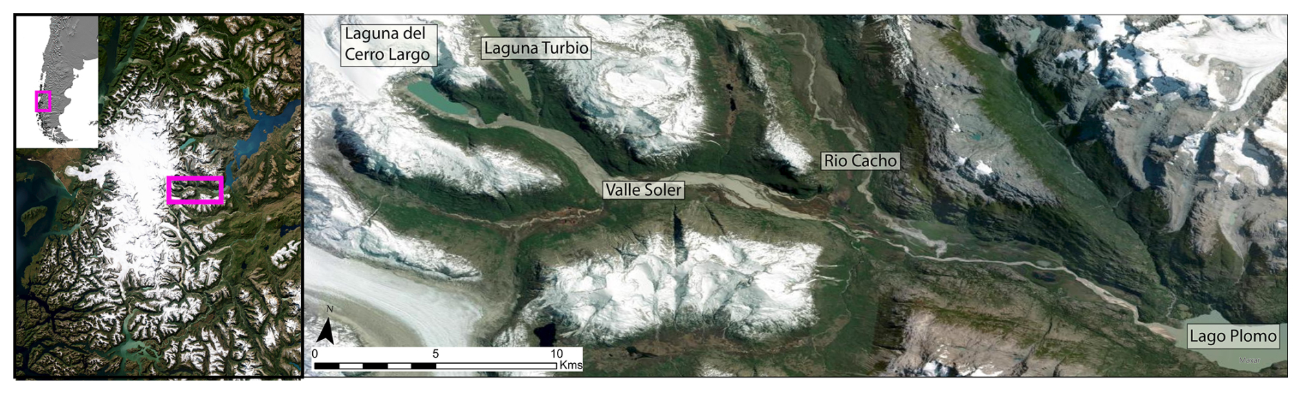
Figure 1Laguna del Cerro Largo and Valle Soler in the Aysén region of Chile. The initial impact zone of the 1989 GLOF is visible in the first 15 km with extensive sediment mobilization and deposition. Esri | Powered by Esri.
The current narratives of GLOF hazard stand in stark contrast to the historical treatment of GLOFs in Chilean Patagonia. Until recently, state and regional governments gave little attention to GLOFs as hazards requiring mitigation; instead, such events were largely accepted as an inherent feature of life in a peri-glacial environment. Although the region has experienced hundreds of GLOFs over the past century (Lützow et al., 2023), Patagonia remains significantly understudied, in part due to its rural character and low population density. However, this historical inattention contrasts sharply with projections of increasing future risk. GLOF frequency and impact are expected to rise in coming decades (Wang et al., 2024), with continued glacial lake expansion and a projected 26 % to 41 % reduction in glacier mass by 2100 under warming scenarios of 1.5 to 4 °C (Rounce et al., 2023; Schuster et al., 2025). This persistent lack of research attention, coupled with unresolved uncertainties surrounding GLOF dynamics and hazard extent, continues to impede effective adaptation and risk governance in the region.
On 16 March 1989, a large GLOF inundated Valle Soler, an isolated glacial drainage on the eastern margin of the Northern Patagonia Icefield (Fig. 1). The flood destroyed three homes, damaged dozens of other homes and property, and killed “a great quantity” of livestock (Hauser, 1993), originating from the failure of a moraine dam retaining Laguna del Cerro Largo (LCL). The flood was one of the largest recent moraine-dammed GLOFs by volume and estimated discharge (Clague and Evans, 2000), even reversing the flow of the Rio Baker – Chile's largest by volume – for several hours. Yet the event received little scientific attention beyond an initial field study (Hauser, 1993) and brief mentions in the broader GLOF literature (Clague and Evans, 2000; Iribarren Anacona et al., 2014).
Here we undertake an interdisciplinary investigation of the 1989 Valle Soler GLOF, drawing on diverse methods to examine both the historical and ongoing impacts of the event. We highlight how integrating physical and local knowledge can improve hazard interpretation and governance in data-sparse mountain regions. While GLOFs are often treated as geophysical phenomena, they also mobilize policy and development planning for disaster risk reduction, requiring approaches that account for both physical and socio-political dimensions of change. To better understand the 1989 GLOF, we present products from numerical modeling of GLOF hydrologic dynamics, and field sediment and dendrogeomorphic samples from a field excursion undertaken in the austral summer of 2024. These diverse datasets comprise a history of GLOF impacts in order to advance considerations of the ongoing impacts on disaster and risk policy today.
Study Area
The Aysén region of Chile is home to some 10 300 glaciers, with approx. 8700 km2 of glacial surface area (Direción General de Aguas, 2022). Glaciers have retreated dramatically over the past century, consequent to anthropogenic climate change (Dussaillant et al., 2019; Hugonnet et al., 2021). Since 1870, glaciers around the Northern Patagonia Icefield have lost 25 % (east margin of NPI) and 11 % (west margin of NPI) of their LIA ice extent (Carrivick et al., 2024). Glaciers along the eastern margin of the NPI have experienced stronger rates of decrease (Carrivick et al., 2024; Dussaillant et al., 2018) while glacial retreat along the western margin has been mitigated in part by increases in frozen precipitation, offsetting the net loss of glacier mass (Troch et al., 2024).
As glaciers retreat across Patagonia, the number and size of glacial lakes continue to grow, with a 27 % increase in glacial lake area from 1986 to 2016 (Wilson et al., 2018). This expansion has heightened concern over GLOFs, which have occurred hundreds of times in the region over the past century (Lützow et al., 2023). Many of the GLOFs that have occurred in Patagonia are located in relatively remote valleys with few downstream populations, but have killed livestock and destroyed barns, houses, bridges, and roadways (Iribarren Anacona et al., 2015, 2023; Jacquet et al., 2017).
However, GLOF hazard exposure is expected to increase due to ongoing development and shifting land use dynamics (Dussaillant et al., 2010; Hock et al., 2019). In Aysén, a recent influx of external investment and infrastructure expansion is rapidly transforming long-standing social and territorial relationships. These changes are especially pronounced in struggles over land governance, where global economic forces have collided with local traditions and rural livelihoods (Blair et al., 2019). The convergence of accelerated socio-economic development and climate change has prompted profound shifts in state-society relations and reshaped the political landscape of land governance.
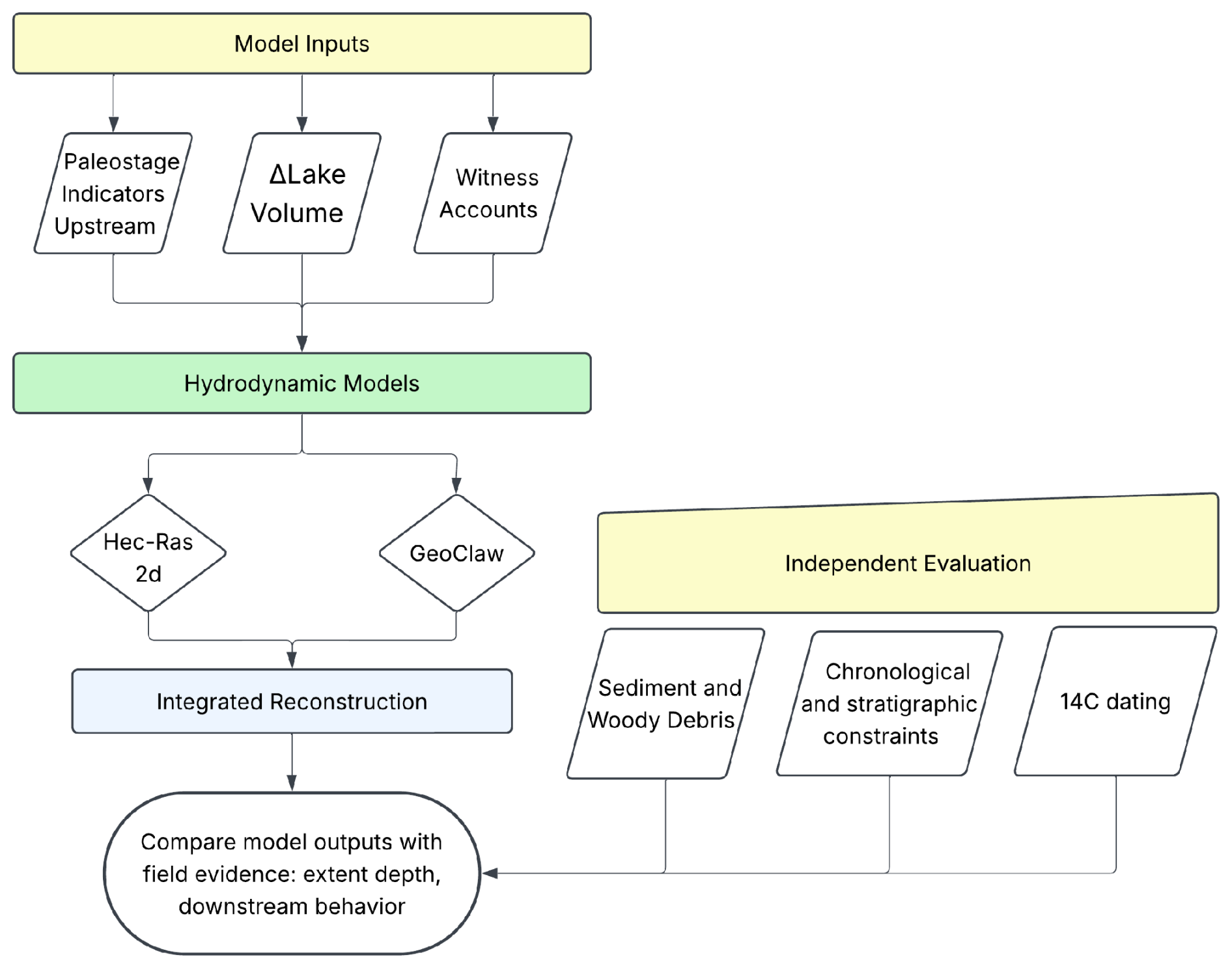
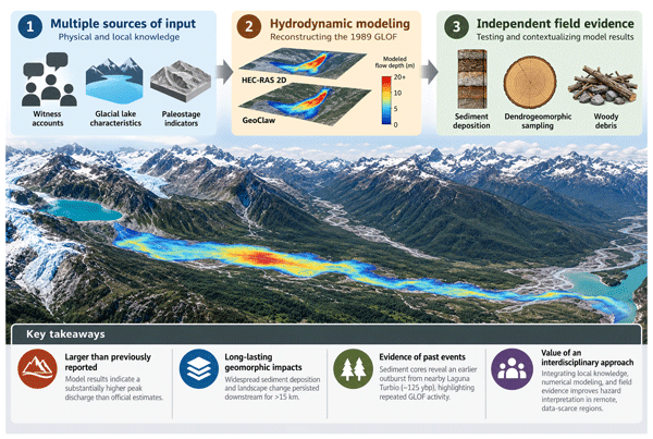
A mixed-methods approach was used in this study, integrating data spanning several years of field work in Aysén. The research involved close collaboration with local community members and followed principles recommended for community-based research (Pearce et al., 2009). This study draws on three complementary lines of evidence: witness testimony, hydrologic modeling, and field-based geomorphic evidence (sediment and dendrogeomorphic sampling), illustrated in Fig. 2. The roles assigned to these data are conceptually distinct even where they draw on the same underlying accounts. Witness accounts were used in two capacities: first, as direct inputs to the hydrologic models, where reported flood duration and flow behavior (e.g., the wall-to-wall inundation of the valley) constrained the breach hydrograph and boundary conditions (Sect. 2.3.1); and second, as qualitative context used to assess the consistency of model outputs with the lived experiences of the event's magnitude and timing (Sect. 4). Because witness accounts inform both model parameterization and contextual interpretation, they are not treated as an independent validation dataset. Evaluation of the model instead relies on field-based geomorphic evidence like sediment deposits and dendrogeomorphic observations that were collected using field sampling criteria established before examining the hydrodynamic model outputs (Sect. 2.4). This approach allows model-predicted flood extent and inundation patterns to be compared against physical evidence not used in model calibration.
2.1 Witness Interviews
The 1989 GLOF occurred in a remote and sparsely populated valley in rural Aysén, with only a few individuals present to witness the event firsthand. To document these accounts, I conducted interviews with the three surviving witnesses who were present in the valley at the time. These interviews documented witness descriptions of flood magnitude, timing, spatial extent, and other qualitative characteristics to inform model parameterization and provide contextual interpretation of the reconstruction. Questions focused on the individual's experience of the event, where they were located, and flood characteristics at specific points in the valley (e.g., depth, duration, magnitude of flood extent), and the immediate aftermath. Additional questions addressed perceived impacts, government response, and adaptive actions, offering insights into how the event was understood locally and how institutional responses unfolded in its wake.
The accounts that were shared were evaluated for relevance to the modeling process, and for qualitative context of the flood processes. Information describing flood duration, timing, and valley-wide inundation was used to parameterize the hydrologic models. Descriptions of flood depth at specific locations and qualitative observations of flood behavior were retained for contextual comparison with model outputs and interpreted alongside geomorphic observations. These observations were not treated as independent validation because they originate from the same witness accounts used during model parameterization.
2.2 Topography and Remote Sensing
Hydrodynamic simulations were conducted using the Copernicus GLO-30 m DEM which provided a common topographic dataset for both the HEC-RAS 2D and GeoClaw models. Using the same DEM for both simulations ensured that differences between model outputs reflected differences in model structure and parameterization rather than terrain inputs. The Copernicus DEM is derived from the TanDEM-X mission, with data acquired between 2010 and 2014 and released for public use in 2019. The DEM covers approximately 480 km2, encompassing the full drainage pathway from Laguna del Cerro Largo through Valle Soler to Lago Plomo.
Because the DEM postdates the 1989 GLOF, it reflects topography modified by flood erosion, deposition, and subsequent geomorphic change. Reconstructing pre-event topography was beyond the scope of this study, as historical topographic data of sufficient resolution were unavailable. We expect the influence of this limitation on the reconstruction to be minor, for two reasons. First, flood routing here is governed by valley-scale confinement rather than by channel-scale geometry. These first-order controls are not sensitive to post-1989 channel migration or sediment redistribution. Second, the scale of any plausible channel adjustment is small relative to the 30 m resolution of the Copernicus DEM, such that sub-grid changes in channel position or bed elevation would not be resolvable within the model terrain. Adjacent Patagonian river systems have likewise experienced only moderate natural channel adjustment over recent decades (Bañales-Seguel et al., 2020). The simulations therefore assume that these changes did not substantially alter the valley-scale controls governing flood routing.
2.3 Hydrologic Flood Modeling
This study compared two flood models, HEC-RAS-2D and GeoClaw (version 5.9.0, 2018) to simulate the March 1989 flood. The two models share a common topographic dataset (Sect. 2.2) but differ in their required input parameters and representation of breach initiation, resulting in differences in simulated flood behavior. The comparison had two objectives: (1) to estimate key flood characteristics – including flood extent, timing, and peak discharge – and (2) to evaluate the influence of model structure by comparing simulations generated from comparable input conditions where possible. The implications of these differing input requirements, along with initial assumptions, are discussed in detail in the following subsections.
2.3.1 HEC-RAS-2D
Input condition parameters are fundamental to accurately determine key flood characteristics such as peak discharge. While parametric equations have been used to estimate input parameters that are often difficult to measure (Allen et al., 2017; Somos-Valenzuela et al., 2016; Westoby et al., 2014), several studies have found outflow hydraulics to be highly sensitive to initial input conditions (Rinzin et al., 2025; Sattar et al., 2021; Wahl, 2004). The breach hydrograph followed Burton et al. (2020), which reconstructed the event using witness-constrained flood duration and estimated lake volume. Witness interviews provided the primary constraints on flood duration, timing, and inundation behavior used to estimate the breach hydrograph. As described in Sect. 2.1, these accounts were used for model parameterization but not as an independent validation dataset – used here as the Δ time of noticeably raised river water.
HEC-RAS-2D has been successfully employed for GLOF reconstruction (Iribarren Anacona et al., 2015; Klimeš et al., 2014; Kougkoulos et al., 2018; Sattar et al., 2021; Wang et al., 2024), and is capable of simulating multidirectional and multi-channel flows, which are characteristic of GLOFs. HEC-RAS-2D solves the Saint-Venant equations, making it suitable for modeling flood routing across complex and steep terrain. However, these equations assume shallow, Newtonian flow which limits the model's ability to represent GLOFs that carry large amounts of sediment or debris.
We modeled the failure of the Laguna del Cerro Largo, designating the storage area (lake) and moraine dam (boundary) as the boundary conditions. The discharge hydrograph was estimated using the total flood volume calculated from Burton et al. (2020), derived from the bulk volume (∼ 140 × 106 m3) over the 8 h of elevated floodwater as described from witness accounts. We compared Qp to parametric equations established within the literature, with 20 000 m3 s−1 most closely matching the observed impacts (see Burton et al., 2020). Dam failure time (Tp, h) was estimated as follows (Froehlich, 1995):
where V is the outburst volume (m3) and hb is the breach height (m). This flow hydrograph was then used as an upstream boundary condition for the downstream two-dimensional GLOF routing. We allowed the simulation to run for 24 h to ensure the simulation ran in its entirety.
2.3.2 GeoClaw
The second model used to simulate the 1989 event is GeoClaw, a hydrodynamic model designed to efficiently solve the shallow water equations over complex topography. GeoClaw, like HEC-RAS-2D, solves the two-dimensional Saint-Venant equations (Berger et al., 2011), but distinguishes itself through its use of Adaptive Mesh Refinement (AMR). This technique dynamically concentrates computational grid cells in areas of rapid change – such as along the advancing flood wave – while maintaining coarser resolution elsewhere.
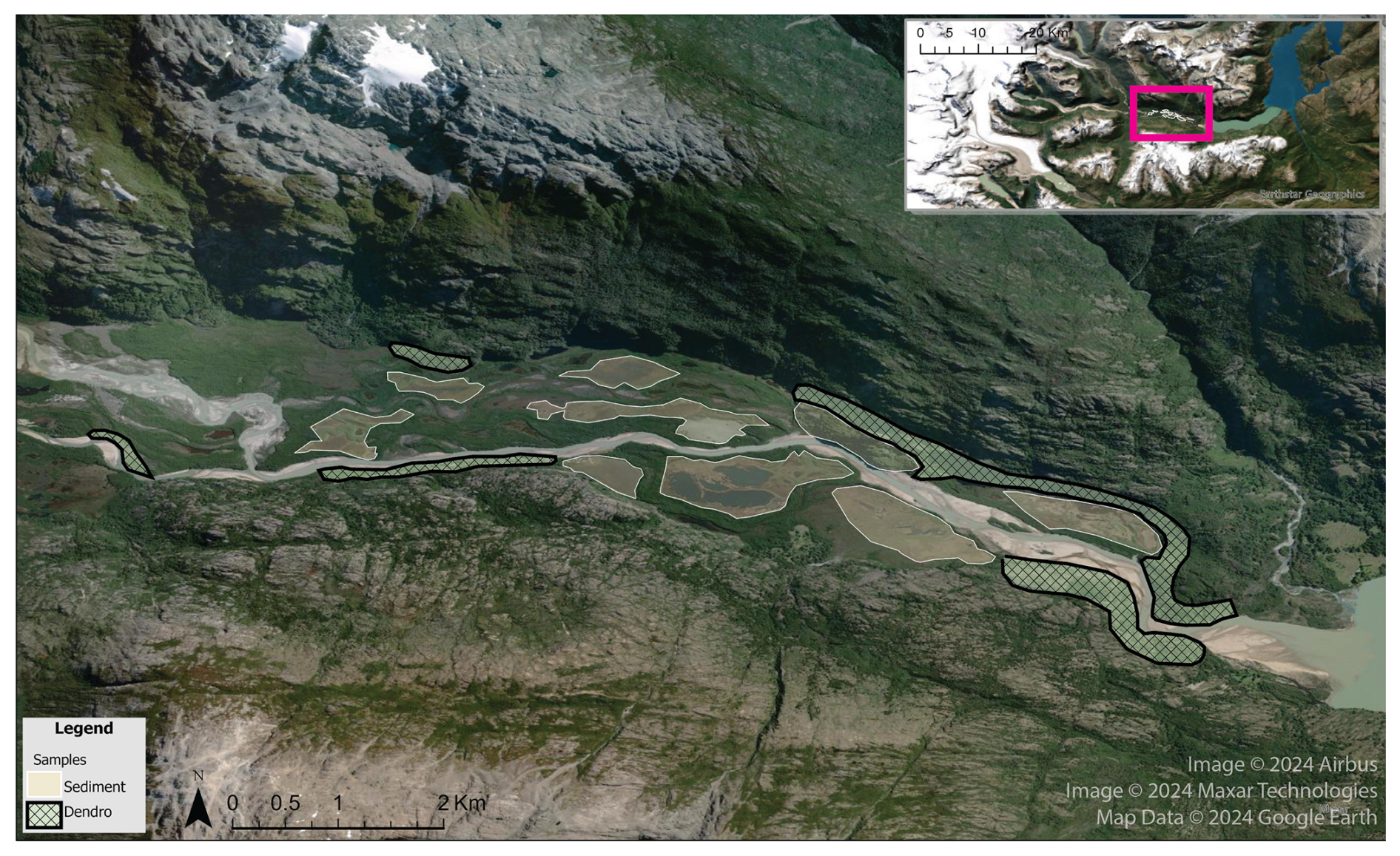
Figure 3Map of identified potential sampling sites for both sediment (tan) and dendrogeomorphic (hatched light green) in the lower Valle Soler. Imagery © 2024 Airbus, Maxar Technologies, Map data © 2024 Google.
The coarse level-1 rectangular grid with a resolution of ∼ 500 m × 150 m covers the extent of the computational domain, a rectangle of size 14 km × 35 km, or approximately 480 km2. Four additional levels of refinement are user-defined input parameters, each at successive factors of 2, such that level-5 refinement is ∼ 10 m. Unlike HEC-RAS, GeoClaw assumes an instantaneous dam failure, creating an artificial wall of water that, upon initiating the flood, calculates the flood wave propagation through the downstream terrain. The AMR capabilities enhance the accuracy and efficiency of modeling by dynamically adjusting the resolution of the computational grid based on specific local conditions during a simulation. The instantaneous release of water is, of course, not reflective of the real and complex process chains entailed by moraine dam incision and reflects an overestimate of downstream impacts. However, researchers have successfully used the model to simulate highly dynamic GLOF conditions (Turzewski et al., 2019).
2.4 Field-Based Geomorphic Evidence and Model Evaluation
Witness testimonies state that the propagating flood wave filled the valley from wall to wall and contained a slurry of sediment-laden water and woody material. This is plainly evident in the initial stretches (< 10–12 km) of the valley (Fig. 1), but these indicators, characteristic of GLOF flows, are more difficult to detect from remote sensing technology and noticeably diminish at ∼ 15 km downstream. At ∼ 12 km downstream, visible signs of sediment deposition largely disappear, seemingly inconsistent with the magnitude of the GLOF. Emmer (2023) discusses the complexity of vanishing evidence of GLOF events, a paradox which motivated the current analysis. For this reason, a sedimentological and dendrologic sampling field campaign was undertaken to compare with the results of the numerical modeling of the GLOF event.
Sampling sites were selected based on anticipated flood impacts, including low-energy environments conducive to sediment deposition and high-energy zones likely to produce dendrogeomorphic evidence of disturbance (Fig. 3). Samples were collected during the same field campaign and are discussed separately in continuation.
2.4.1 Sediment Samples
Following Vandekerkhove (2021), likely zones of sediment deposition were identified through analysis of the downstream glaciofluvial valley. A suitability analysis in the Valle Soler identified regions that were accessible and had an increased likelihood of successful sample extraction. The following characteristics were used to identify these regions:
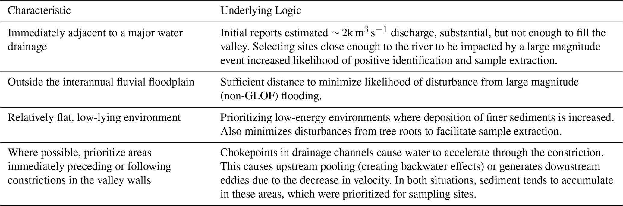
We extracted samples from humedales, a type of peat wetland present throughout the periglacial landscapes of Patagonia, with a Russian Peat Auger (RPA) and Soil Probe (Fig. 4). The RPA is a hollow steel tube, attached to a steel handle, with one side covered by a metal sheath that, when inserted into water-saturated sediment, is rotated to separate the sediment sample from the ground matrix so that the now enclosed sediment can be extracted. This sampling method preserves the small-scale depositional structures and stratigraphy of the soil, and has been used to analyze GLOF deposits (Vandekerkhove et al., 2020). The soil probe is a simpler contraption that was used primarily as an initial probe into the soil to test if the RPA would be appropriate. In some locations, we were unable to insert the RPA into the ground but were able to extract smaller samples with the soil probe.
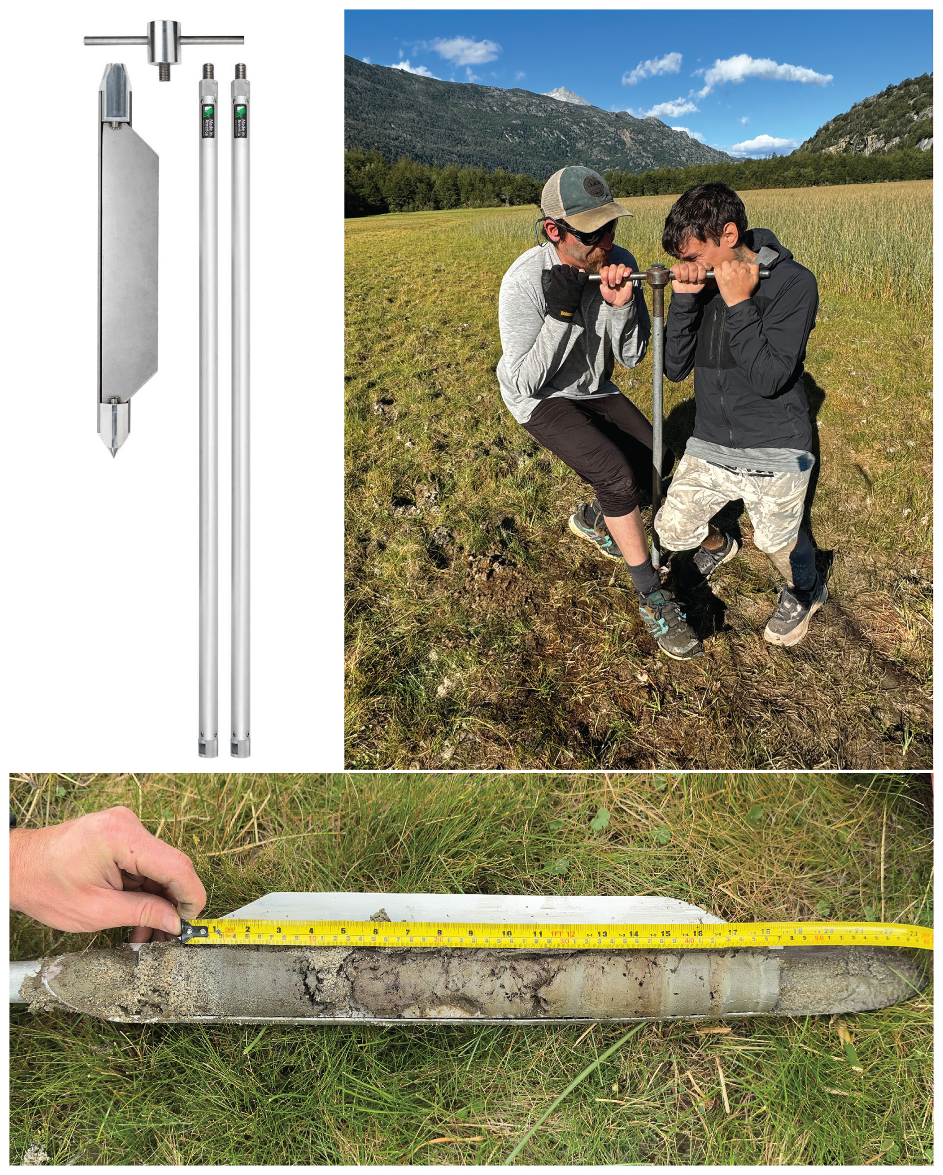
Figure 4Russian Peat Auger (RPA) used in the field. The auger is pushed into substrate (top-right), and rotated to close the gate, isolating the sediment core from the substrate.
2.4.2 Dendrogeomorphic Samples
Dendrogeomorphology is the analysis of tree-rings and growth patterns to understand geomorphologic processes, and has been successfully used to date and analyze floods (Ballesteros-Cánovas et al., 2015; Casteller et al., 2015), debris flows (Bollschweiler and Stoffel, 2010), and other geomorphic processes (Stoffel and Corona, 2014). In dendrogeomorphic studies, the primary unit of analysis is growth disturbances (GDs) in the tree-ring record, which reflect external stresses experienced by the tree. These are often expressed as a decrease in springwood width (the lighter portion of the growth ring) compared to the springwood of adjacent annual rings.
Table 2Dendrogeomorphologic Sample Extraction Characteristics.

We used high-resolution images from Google Earth and Landsat 8 OLI to identify areas of high likelihood of GD. Similar to the sediment samples, we identified potential sampling sites based on several expert-informed sampling strategies, summarized in Table 2.
Originally, the research plan was to identify visible scarring which would be used to sample the date of scarring (Ballesteros-Cánovas et al., 2015; Gorsic et al., 2025), yet a lack of prominent and identifiable visible scarring required a change of strategy to statistically relate GDs in tree ring thicknesses. We opted to find trees that would have been impacted by stressors such as the impact wave, damage from passing debris, or other geomorphic changes that would have induced stress for the growing conditions of the tree. We collected n = 50 samples from several species of the Nothofagus genus (Southern Beech), including N. pumilio (Lenga), N. betuloidus (Coihue), and N. dombeyi (Ñirre). Although these species have been effectively used in dendrochronological studies in Patagonia (Gorsic et al., 2025; Winchester and Harrison, 2000), their application to assessing impacts from GLOF events remains limited. We collected samples from trees with a diameter between 15–35 cm. Where possible, we identified trees that had visible scars on their stem surface, which we interpreted as reflecting impact of passing debris from the 1989 flood event.
Samples were analyzed and processed following standard procedure (Bollschweiler et al., 2008; Stoffel and Corona, 2014). Sample size was not predetermined but driven by the time available in the field. Additionally, sampling sites were selected independently of model results. Samples were mounted on a slotted mount and prepared with a 600-grit sandpaper that allowed for ring identification. Using the CooRecorder 9.0 software (Larsson, 2013), we counted tree-rings and measured widths from high-resolution (1200 dpi) digitized images, and transferred output files into COFECHA (Holmes, 1983) for cross-dating analysis.
2.5 Carbon-14 Dating
We collected two samples (n=2) of buried vegetation from stratigraphically distinct organic horizons within downstream sediment deposits to constrain the age of a previously undocumented GLOF event inferred to have originated from Laguna Turbio (Fig. 1) and whose geomorphic impacts are visible in historic remote sensing imagery. Using the RPA, we recovered two distinct organic layers from a stratigraphically continuous sequence, each representing a buried vegetation horizon. The shallower organic horizon directly underlies the upper clastic unit attributed to the 1989 GLOF, whereas the deeper organic horizon underlies a second, older clastic unit interpreted as evidence of an earlier flood. Our objective was to test whether the upper horizon yielded a modern age consistent with the 1989 event and whether the deeper horizon provided a maximum age constraint for the older flood deposit. The two samples were processed as bulk carbon and analyzed in the University of Colorado Boulder AMS Radiocarbon Prep Laboratory. Although the sample size is limited, additional radiocarbon analyses were beyond the scope of this study due to analytical costs.
3.1 Witness Accounts of the Flood
We used witness accounts of the flood to constrain key parameters used as model input (full interviews are found in Part S1 in the Supplement), using their locations and descriptions of flood behavior. According to those who witnessed the event, there were only four people in the valley when the flood occurred, three of whom are surviving. I spoke with all three of the surviving witnesses to reconstruct the flood using the hydrologic models. From the interviews, we gathered important discrepancies from descriptions of the previous scientific accounts. First, two brothers and a third helper were working in the upper section of Valle Soler when they saw the rushing wave of water. They describe a “rapidly descending flurry of water” that “filled from valley wall to valley wall” (de cordillera a cordillera). One worker had to rapidly climb a tree, some 6–8 m high to avoid being swept away, and the brothers scrambled up a nearby hill.
These accounts contrast dramatically with the hydrologic model results of peak discharge estimates by Hauser (1993) which calculated, from empirical relations, the discharge to be around 2000 m3 s−1. Modeled results with Hauser's peak discharge were insufficient to replicate the magnitude and depth of flooding witnessed (Burton et al., 2020). Second, the mode of moraine failure differed among accounts. From the initial report, Hauser posits an iceberg likely blocked the outlet causing the eventual failure of the dam, either from overtopping or compromising the dam as the water moved around the blockage. This differs from the witness accounts, all of whom did not mention an eventual increase of floodwater but describe the advancing flood wave as “all-at-once”, leaving them with little time to escape. Two witnesses stated they thought the moraine must have failed from below to release so much of its waters so rapidly.
Further downstream, the third witness describes his account of the flood (Part 1b in the Supplement), which was used to contextualize the rapid onset of the descending flood wave, as opposed to a gradual deepening more consistent with the original estimation of flood discharge.
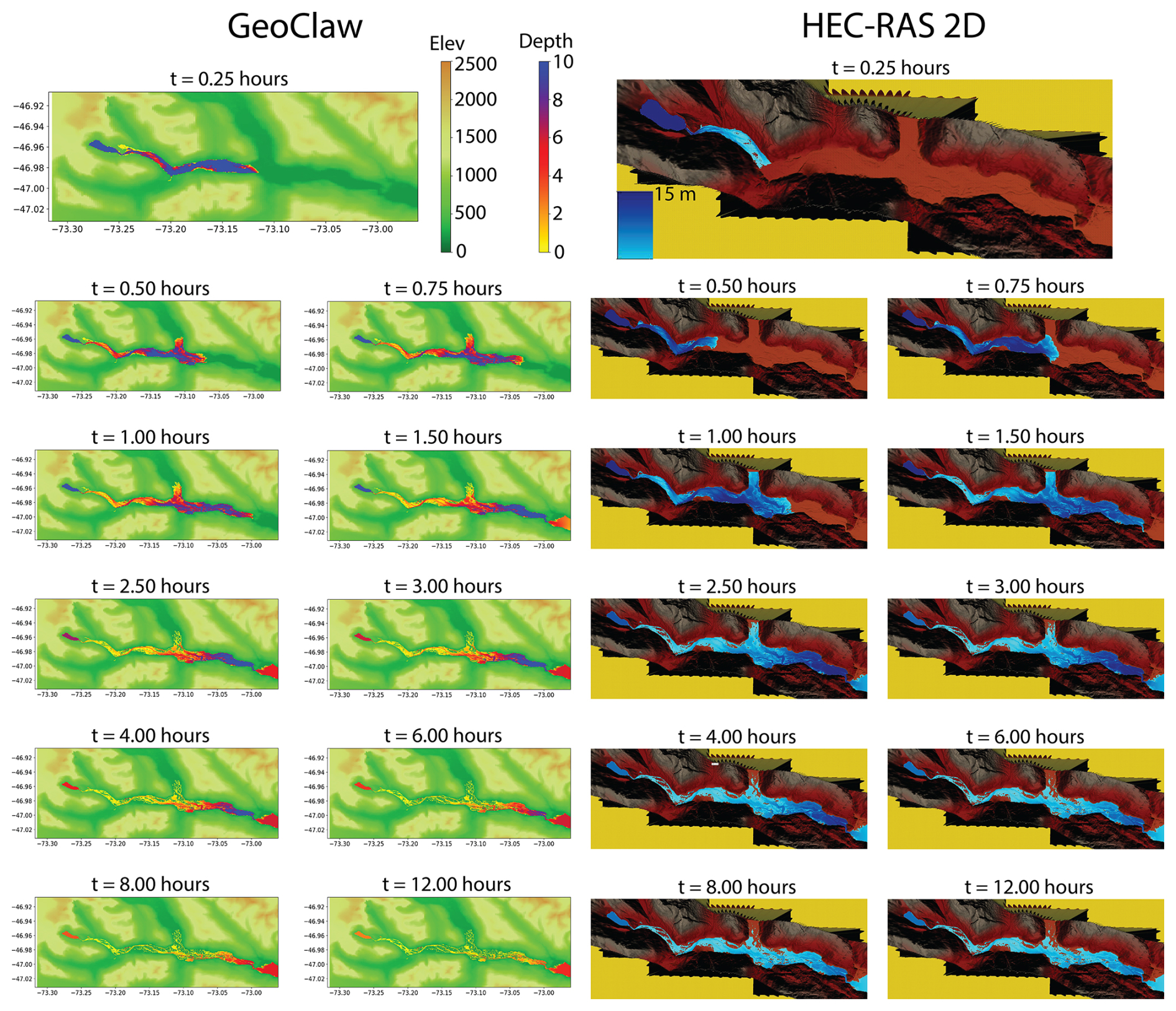
Figure 5Comparison of simulated flood wave progression from GeoClaw and HEC-RAS-2D models as a function of time since breach initiation (Δt). The HEC-RAS model shows a lag in wavefront propagation relative to the GeoClaw results.
3.2 Hydrologic Models
Hydrologic model outputs of the 1989 event largely coincide between the two approaches, yet important differences arise based on the different initial assumptions (Fig. 5, videos S2 in the Supplement). As noted by Turzewski et al. (2019), the assumption from GeoClaw of instantaneous dam failure leads to higher peak discharges and shorter time to peak discharge than would otherwise be expected. This is evident through an apparent 15–30 min advance in the GeoClaw simulation compared with HEC-RAS-2D at the same Δt.
The GeoClaw simulation fully floods the downstream valley filling the canyon walls with 10 m of water, reaching the Rio Cacho tributary (Fig. 1) within the first 15 min. The flood loses energy upon reaching the wider stretches of the middle Valle Soler, and the advancing flood wave attenuates to a height of 4–6 m. A portion of the flood is diverted north, moving upstream of Rio Cacho. Within only 60 min, the wave front has nearly reached the end of the valley while the main bulk of water volume accumulates into a trailing pulse of water growing and diminishing in height with the contours and constrictions of the valley walls. By the end of the first hour, the bulk volume of the flood reaches the furthest stretches of Valle Soler, where an end moraine creates an abrupt constriction with two near 90° diversions that causes the water to pool 10 m deep as it moves through the constriction and drains into Lago Plomo.
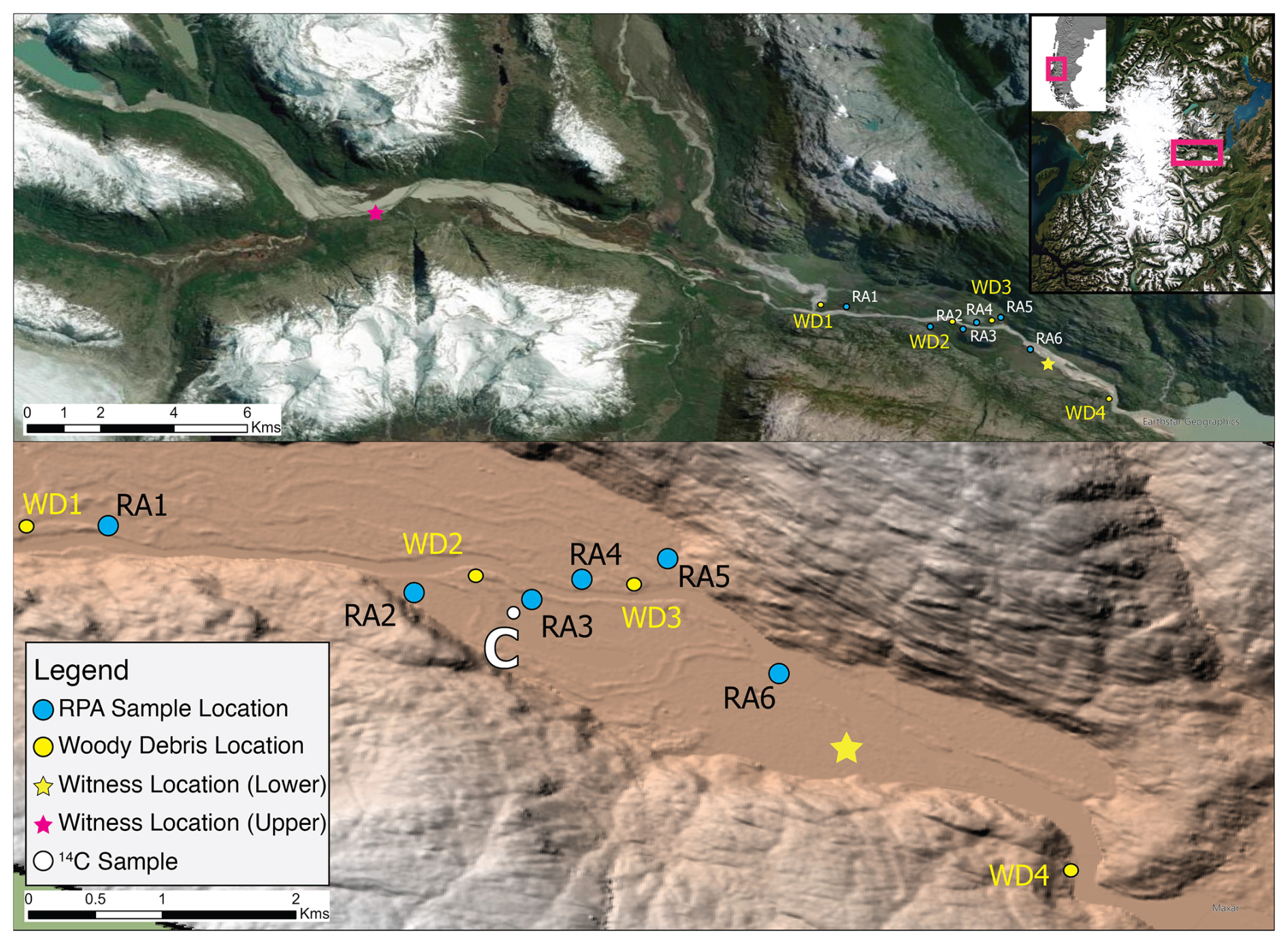
Figure 6Map of the samples collected in the lower stretches of Valle Soler. The blue dots represent sediment cores extracted by the Russian Peat Auger. The yellow dots represent woody debris found in the field. The stars indicate the location of the campesinos when the flood occurred. The white “C” symbol represents where the carbon sample was extracted for 14Carbon dating. Esri | Powered by Esri.
HEC-RAS-2D, by contrast, includes a dam-break module that allows users to define initial conditions replicating the physical characteristics of a dam. In this case, the gradual erosion of the terminal moraine moderates the downstream propagation and reduces the depth of the advancing flood wave (Fig. 5). The simulation initiates with shallow overtopping that begins flooding the upper section of Valle Soler, followed by the main flood wave breaching the moraine and overtaking the initial inundation front. Notably, there is a time lag of approximately 30 min in the arrival of the bulk flood pulse in the HEC-RAS simulation compared to GeoClaw for comparable downstream locations. The bulk flood pulse similarly reaches depths exceeding 10 m, dependent on the constrictions of the valley width, accumulating at the final constriction at 90 min. The bulk flood pulse pools at this constriction for some 3–4 h as the outlet slowly drains the floodwater into Lago Plomo.
3.3 Sediment Samples
The sediment deposited by the 1989 Soler GLOF displayed a range of depositional environments (Fig. 6). Sediment ranged from silt- and clay-sized particles (approximately φ = 4–6) to coarse sand (approximately φ = 1–3), interspersed with organic horizons. When extracting sediment samples, we interpreted the first non-organic lens of clastic sediment to be most likely deposited by the 1989 GLOF, informed by several field workers' (herein referred to as campesinos) accounts' that Rio Soler had not flooded its banks since the 1989 GLOF. Although our field samples and analysis did not permit an in-depth sedimentological analysis (e.g., grading or sedimentary structures), the interpretation of this unit as a single-event deposit is supported by its consistent occurrence as a discrete clastic layer bounded by organic horizons across all sampled cores, together with the modern radiocarbon age and the absence of any known overbank flood of comparable magnitude since 1989. The organic horizons similarly varied in thickness, which we attributed to the various geomorphic environments in which they were found (i.e., low-lying wetland, seasonal pasture, raised floodplain). While individual core thicknesses varied between sites, reflecting local depositional environments (wetlands, raised floodplains, backwater settings), the upper clastic unit was present throughout the sampled reach. This consistency suggests that the 1989 GLOF deposited a valley-wide depositional unit, rather than isolated overbank deposits. Farther downstream, the cores also record a progressive fining from coarse sand toward finer sand and silt, consistent with the modeled attenuation of flow energy as repeated valley expansions promoted lateral spreading and sediment deposition. Rather than abrupt changes in depositional style, grain size exhibits an overall downstream fining trend at the valley scale, while local variations in deposit thickness and texture reflect depositional environment (e.g., wetlands, backwater settings, raised floodplains, and areas adjacent to topographic constrictions).
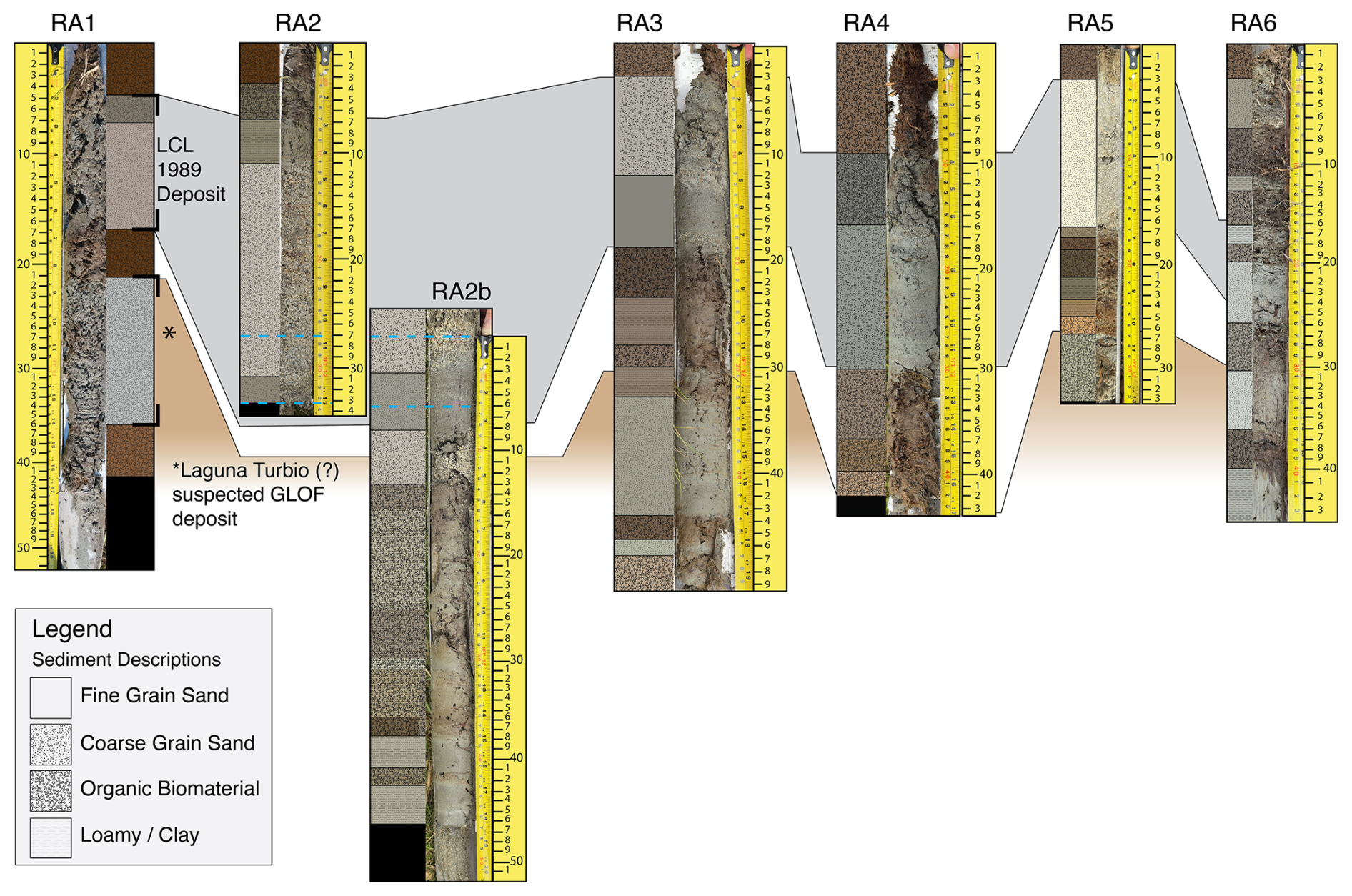
Figure 7Lithology of extracted sediment cores RA1-6. Sediment was extracted using an RPA in the floodplain of Valle Soler. Sediments deposited from the 1989 GLOF (grey) are present in each of the extracted cores, characterized by coarse, silica-rich sand with an organic horizon above and below the deposited sediment. In four cores a similar sediment stratum (∗ light brown) is present below the 1989 deposition and is believed to have originated from a GLOF from the Laguna Turbio basin. 14C dating revealed this GLOF took place late 19th/early 20th century. Detailed descriptions of the sediment lithology found in Part S3 in the Supplement.
In all, we collected six sediment samples using the RPA (Part S3), and another nine using the sediment probe (Fig. 7). At each site, we typically extracted two pilot probes using the sediment probe to gain a snapshot of the substrata, but a malfunction with the rotating blade on the RPA inhibited further use at several locations, as the sediment was either too dry (would crumble apart) or oversaturated with water (and would not hold its shape once extracted).
3.4 Dendrogeomorphologic impacts
A total of 50 cores were extracted from N. pumilio (Lenga, n=34), N. betuloidus (Coihue, n=10), and N. dombeyi (Ñirre, n=6). Where several studies have successfully related growth disturbances of trees with geomorphological processes such as flash floods (Casteller et al., 2015) and debris flows (Bollschweiler and Stoffel, 2010), few studies have related dendrogeomorphic samples with GLOFs (Gorsic et al., 2025), and this is still a developing science. In the field, we found many trees to have a strong outer bark, but to be soft and rotten on the inside beyond a few centimeters (∼ 6–10 cm). We later found out that Nothofagus species are impacted by a spreading fungus which produces similar symptoms of inner rot, particularly in wetter environments (Cwielong and Rajchenberg, 1995) that significantly inhibited a more robust sampling for dendrogeomorphologic impacts. Indeed, upon subsequent analysis, we found fourteen of the samples to be partially rotten to such a degree that we were unable to extract reliable ring counts from them and had to be discarded. Seven samples from these did not reach the desired temporal extent to capture the 1989 event and were similarly unusable. Of the remaining n = 29 samples, we were only able to obtain a series intercorrelation of r= .343 convergence on the tree ring growth disturbances. For this reason, we opted to abandon the dendrogeomorphologic data.
Some older living trees retained large scars on the upstream side of their trunks, likely sustained by the initial impact of the debris-laden flood wave. We were unable to extract dendrogeomorphic samples from these scarred trees, however: those with visible scarring were either rotten from the fungus described above or sufficiently large that our tree corers could not reach the relevant growth rings.
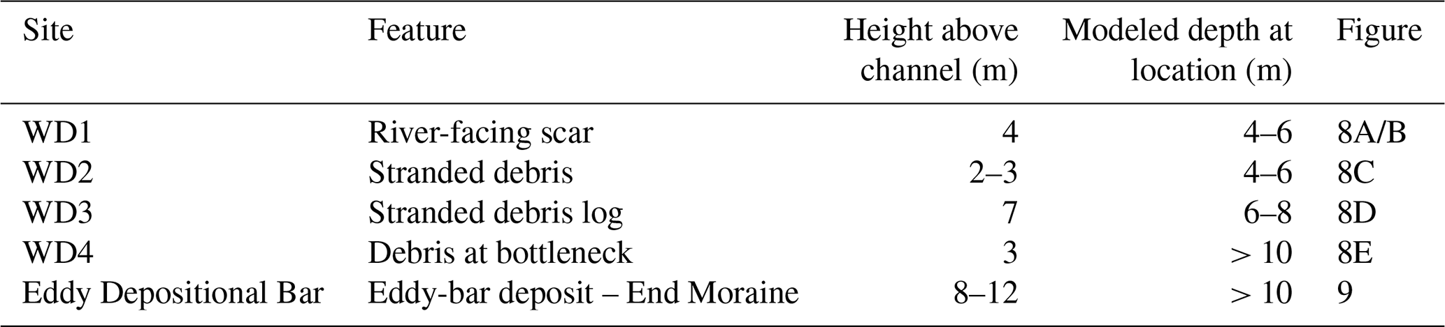
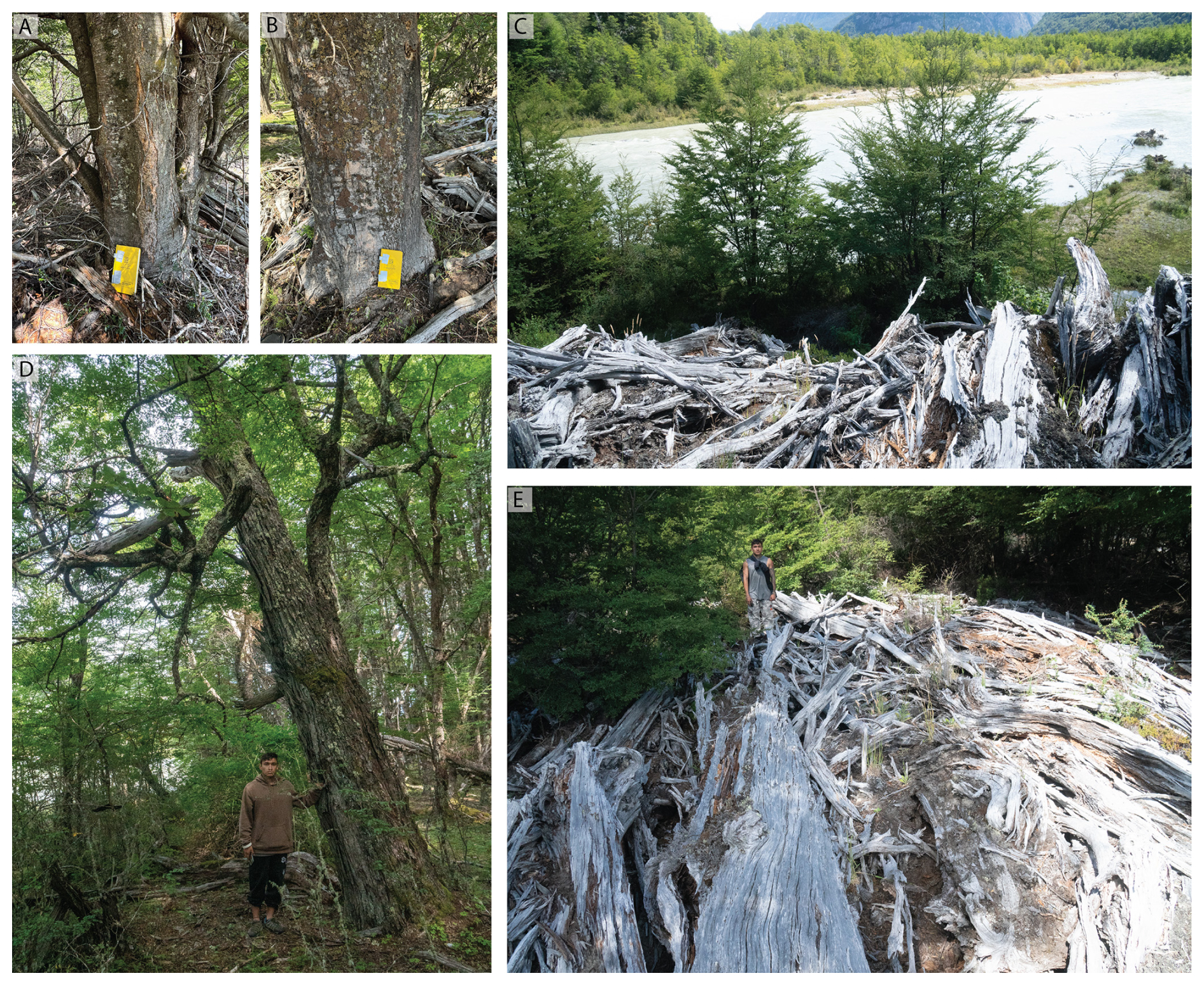
Figure 8Dendrogeomorphologic impacts from the 1989 GLOF. Images (A) and (B) indicate scarring found on the river-facing aspect of two large Nothofagus Pumilio (Lenga) trees. Images (A)–(C) were captured at WD1. Image (D) (WD3) shows a remnant log that was likely stranded in the canopy of another tree, given the advanced state of decomposition which matched other accumulations of woody debris. Image (E) was taken at WD4, likely caught as the leading wave front passed through the topographic bottleneck. Measured scar and debris heights are reported in Table 3.
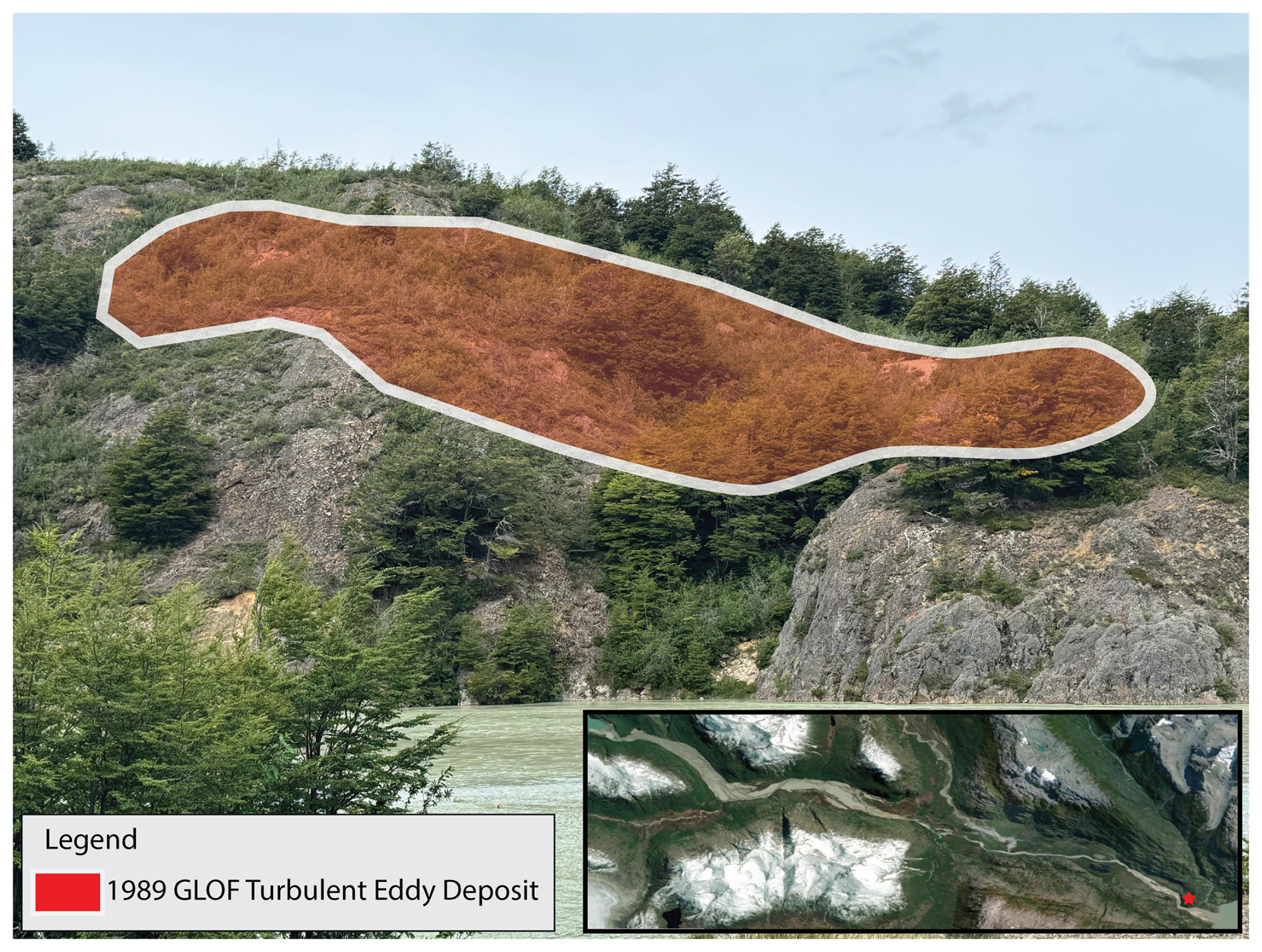
Figure 9Flood eddy deposit observed on the outlet of the constriction (opaque red). This was likely deposited during the backwater accumulation of water, as it drained from the topographic constriction near the outlet of the river into Lago Plomo (river flow direction is left to right).
Although the ring-count analysis was abandoned, the physical scars and stranded debris themselves record useful information on flood stage, independent of the cross-dating statistics. At five sites we measured the height and orientation of flood-related scars and stranded debris as approximate paleostage indicators (Table 3; Figs. 8 and 9). Scars occurred consistently on the upstream, river-facing aspect of trunks, indicating the passage of a debris-laden flow advancing down-valley. Measured impact heights ranged from approximately 3 to 7 m above the present channel, including remnant debris stranded ∼ 7 m above the river surface (Fig. 8D). The stranded trunks were uniformly decayed and piled several meters above the current Río Soler high-water bank, indicating that they had accumulated over some time (decades) and were unlikely to have been deposited by normal seasonal high flow. These heights are consistent with the several-metre flow depths reconstructed at each location. Where scar heights fall below the modeled depth, most notably at the WD4 bottleneck (Table 3), this is expected, since debris caught by the passing leading edge of the wave records local arrival stage rather than the deeper peak inundation that developed later at the constriction.
Finally, the topographic constriction in the lower valley caused floodwater to pool temporarily before being funneled through the narrow channel toward Lago Plomo. The prominent eddy-bar deposit at this constriction (Fig. 9), situated approximately 8–12 m above Río Soler, was likely emplaced as the impounded water drained – representing the highest paleostage indicator recorded and consistent with the > 10 m pooling depth reproduced by both models at this location.
3.5 Carbon-14 Dating of Laguna Turbio GLOF
Clear geomorphic indicators of the 1989 flood are still present in the valley. However, these same features complicate the interpretation of additional evidence pointing to an earlier GLOF event that also impacted the landscape. For example, an analysis of sediment transportation during the 1989 event showed a counterintuitive coarsening of grain size in the initial 5 km of Valle Soler, before a gradual fining below the outlet of Lago Turbio (Fig. 1). While planning for the field expedition, remote sensing analysis suggested a prior outburst flood originating from the adjacent Laguna Turbio. Field observations supported this hypothesis, revealing multiple indicators of a past GLOF: a breached terminal moraine, a visibly lowered lake level, a downstream impact zone, and a consistent reduction in tree size across the suspected flood path – suggestive of uniform re-colonization following disturbance (Emmer, 2023).
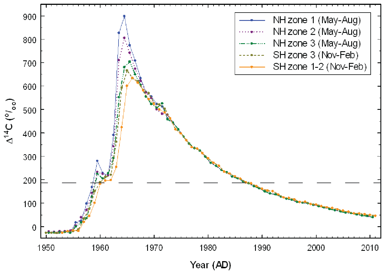
Figure 10From Hua et al. (2013). Compiled (extended) monthly atmospheric Fractional 14C curves for 5 different zones (NH zone 1, NH zone 2, NH zone 3, SH zone 3, and SH zone 1–2). Chile is within SH zone 2 (orange solid).
We extracted and analyzed organic material from sediment samples extracted with the RPA to date the deposition of clastic sediment on top of the vegetation layer that we assumed as preexisting peat vegetation present before the 1989 GLOF. The sample was extracted near RA 3 (White “C” – Fig. 6) and was approximately 50 cm deep. The 14C sample taken from the organic horizon below our target clastic depositional layer returned “modern age”, with a fractional carbon at 1.1921 (Fig. 10). This indicates a high likelihood that our collected 14C sample was taken from organic material deposited in or relatively close to the 1989 flood. The second 14C sample measured a final fractional carbon ratio of 0.9845, with an estimated age of 125 ybp (SD 20), which, relative to the time of analysis (2024), would place the GLOF event took place in 1899 ± 20 years.
4.1 Initial Conditions and Flood Dynamics
The combined witness accounts, hydrodynamic simulations, and geomorphic evidence indicate that the 1989 Laguna del Cerro Largo GLOF resulted from rapid catastrophic moraine failure rather than progressive outlet blockage. Together, these complementary lines of evidence point to an abrupt breach that generated a high-energy flood wave capable of transporting exceptionally coarse sediment throughout the upper valley. Witnesses did not observe a gradual onset of floodwater that would have signaled an impending flood; rather, they describe the main flood surge quickly overtook the initial wave front, with the advancing flood wave likely reaching several meters in height. The rapid advancement of the flood wave is corroborated by both hydrologic models, as well as witness testimony.
Hauser (1993) proposed that outlet blockage by an iceberg initiated overtopping and progressive moraine incision. While that mechanism cannot be excluded, it is less consistent with the evidence assembled here. All eyewitnesses independently described an abrupt flood onset with little warning, and both hydrodynamic reconstructions reproduce a rapidly propagating flood wave rather than a prolonged period of increasing discharge. Together with the late austral summer timing of the event and the absence of a substantial ice apron on the cirque headwall, these observations are more consistent with catastrophic overtopping initiated by a large icefall-generated displacement wave, as has occurred in other regions of the world (Colavitto et al., 2024; Hubbard et al., 2005; Shugar et al., 2021).
The Soler GLOF illustrates how rapidly GLOF rheology can evolve during downstream propagation. Mobilization of boulders exceeding 8 m in diameter (Fig. 11) indicates that the initial flood behaved as a dense, sediment-rich flow capable of transporting exceptionally coarse material. However, multiple valley expansions, abrupt channel bends, and decreasing valley gradient promoted rapid lateral spreading and energy dissipation within the first ∼ 12 km downstream. As sediment deposition progressively reduced the suspended sediment concentration, the flood transitioned toward a more water-dominated flow. Coarse gravel and sandy deposits attributable to the 1989 event were continuously identified over approximately 12 km downstream from the breach, with deposition bars found more dispersed farther downstream. The sediment cores independently record this downstream evolution. Although individual deposits varied in thickness according to local depositional setting, the upper clastic unit attributed to the 1989 GLOF was laterally continuous across all sampled sites and consistently ranged from coarse sand in the upper valley to finer sand, silt, and clay downstream. This pattern indicates that first-order depositional processes were governed by valley-scale topographic controls, with repeated expansions and constrictions progressively attenuating flow energy while producing a broadly consistent depositional signature throughout the lower valley.
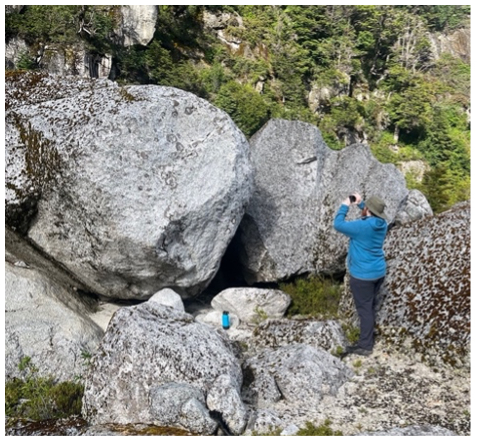
Figure 11Image of boulders mobilized by the 1989 GLOF in the upper Valle Soler, some of them measuring over 8 m (photo taken by Cris Enriquez).
Table 4Comparison to other glacial lake outburst floods in northern Patagonia.
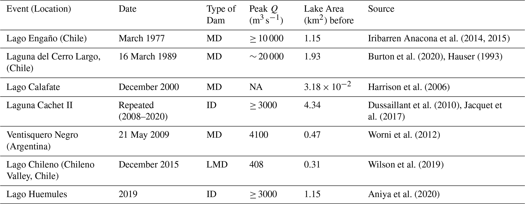
Moraine Dammed: MD, Ice Dammed: ID, Lateral Moraine Dammed: LMD, Not Available: NA.
Regional comparison places the 1989 Laguna del Cerro Largo event among the largest documented GLOFs in northern Patagonia (Table 4). Although direct comparison between historical events is complicated by differences in reconstruction methodology and dam type, Laguna del Cerro Largo occupies the upper end of the magnitude spectrum for moraine-dammed GLOFs in the region. This comparison also highlights the limitations of applying empirical peak-discharge relationships beyond the range of events from which they were derived. In this case, extrapolation of commonly used parametric equations substantially underestimated the magnitude of the 1989 flood, suggesting that physically based hydrodynamic reconstruction may be more appropriate for exceptionally large moraine-dammed lakes that lie outside the calibration range of existing empirical relationships.
The exceptionally large, reconstructed discharge must, however, be interpreted within the assumptions of the modeling framework. Both hydrodynamic models solve the shallow-water (Saint-Venant) equations and therefore assume Newtonian flow, an assumption least valid in the upper valley where boulder mobilization (Fig. 11) indicates the flood likely behaved as a dense, debris-rich slurry rather than clear water. A non-Newtonian flow of higher bulk density and yield strength conveys a given discharge at greater depth than the models assume; conversely, reproducing the observed inundation depths with a Newtonian model requires a larger water discharge than the true water-plus-sediment flux. This is consistent with our interpretation that the reconstructed peak discharge represents an upper bound. Importantly, this bias is spatially concentrated: as the flood attenuated and spread laterally within the first ∼ 12 km, losing turbidity and sediment load, the flow approached the clearer, more Newtonian regime for which the shallow-water assumption is best suited – the same downstream reaches where our sediment and witness-based evaluation is concentrated. We therefore treat the upper-valley discharge estimates as first-order approximations of a debris-influenced flow, while regarding the downstream reconstruction, against which the field evidence is compared, as less affected by rheological simplification. Full debris-flow rheological modeling was beyond the scope of this event reconstruction but represents a valuable direction for future work, especially as recent work has highlighted these important discrepancies (Lehnigk et al., 2026).
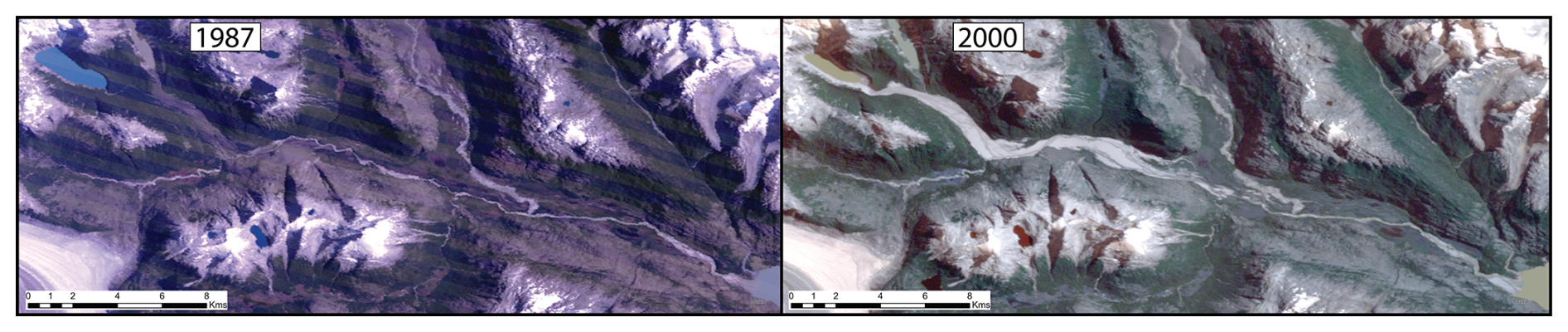
Figure 12Historic imagery Landsat 5 (TM) of Valle Soler. Valle Soler deposits are clearly visible in the post-GLOF (2000) image, and similar impacts are visible emanating from Laguna Turbio.
4.2 (Mis)Reading the Landscape
The lack of easily accessible and decipherable evidence of previous GLOF impacts in the lower reaches of Valle Soler raises important questions regarding the legibility of GLOF indicators, similarly analyzed by Emmer (2023). Beyond the initial sediment redistribution of upper Soler, the lower portions of the valley remained seemingly undisturbed, with fewer geomorphological impacts visible from available remote sensing (Fig. 12). Moreover, compounding GLOF events, such as occurred with LCL and Laguna Turbio, further complicate the legibility of even large-magnitude GLOF events. The relative uniformity of the upper clastic unit despite substantial differences in local geomorphic setting also illustrates how major GLOFs can leave deceptively subtle downstream sedimentary signatures, particularly once vegetation has recovered.
Conventional methodological approaches to estimating peak discharge in GLOF events can significantly misrepresent the true magnitude of these extreme events, particularly when applied beyond the empirical range of their original datasets. In this case, the initial empirical equations used by Hauser (1993) to estimate peak discharge (Qp) underestimated the flood by nearly an order of magnitude. This discrepancy likely stems from the unusually large volume of Laguna Cerro Largo (LCL), which exceeds the scale of events used to derive those equations. The formula that was applied in the official report relates discharge (Qp) to the volume of water drained, yet the case studies collated into this database were collected from ice-dammed lakes (Clague and Mathews, 1973), skewing the results in the 1989 Soler GLOF. Other formulae, like Costa and Schuster (1988) were based on data linking Qp to the calculated potential energy of the impounded lake. Those data points ranged from approximately 1010 to 1012 J, whereas calculations with data taken from Burton et al. (2020) suggest a potential energy closer to 1014 J – 2 orders of magnitude greater.
The limitations of empirical formulae become more evident when compared to eyewitness testimony. All accounts, given by individuals located at different points in the valley, consistently describe a sudden onset of a high-energy, torrential flow that stood several meters tall. Witnesses reported that the floodwater rapidly inundated the entire valley floor, reaching depths of several meters at their respective locations. These descriptions sharply contrast with Hauser's estimated peak discharge (Qp) of 1800–2000 m3 s−1. At that rate, and assuming sustained peak flow, it would have taken approximately 31 h to drain his estimated flood volume of 229 × 106 m3 (Hauser, 1993). In contrast, interviewees recalled that the bulk of the flood passed through in just 8 h – long enough for one campesino to spend the night in a tree, which he had climbed 6 to 8 m above the ground to escape the rising waters. This discrepancy suggests that the original discharge estimate significantly underestimated the true magnitude of the event.
While these empirical equations have been reanalyzed and calibrated in the decades since, it is important to note that the applied results of these formulae are often not, with lasting consequences for policy and hazard planning. Local policymakers and scientists were more familiar with estimates in the 2000–3000 m3 range, citing Hauser (1993) and the cyclical ice-dammed GLOFs from Cachet II (Jacquet et al., 2017; Personal Communication, 2024). Discrepancies like these comprise a potentially dangerous miscommunication that impacts subsequent development of policy and emergency preparedness plans.
4.3 Disciplinary Blind Spots and Interdisciplinary Advantages
GLOFs have been studied predominantly from glaciological and other Earth science perspectives. While contributing a foundational geophysical understanding of the complex process chains and downstream impacts, the remote nature of these processes complicates analysis where data are often sparse or non-existent. As illustrated by Williams et al. (2022), triangulating an understanding of geomorphic events such as GLOFs using diverse data can help reconstruct geomorphic processes in data sparse areas.
The 1989 Soler GLOF is readily identifiable in satellite imagery, with distinct geomorphic signatures detectable via remote sensing. However, the temporal resolution is constrained by the infrequent revisit times of early satellite platforms at mid-latitudes and by persistent cloud cover, customary for this region. Additionally, repeat events, such as the overlaid GLOF deposition from the Soler and Turbio GLOFs, obscure the prior events and their visible indicators.
Witness testimonies were integral to providing crucial data for the hydrologic models. Further, their local expertise and intimate familiarity with the landscape provided additional details that would be otherwise exceedingly difficult to extract via remote sensing. For example, the dense vegetation present in the valley has all but obscured the most obvious of geomorphic features of the outburst flood. Moreover, local familiarity with the land is an underappreciated source of knowledge in scientific research (Balay-As et al., 2018; Cadag and Gaillard, 2012). Campesino accounts of a rapid and catastrophic moraine dam failure aligned more closely with the results of the hydrologic simulation than with the moderated descriptions and initial reports. Community members also demonstrated awareness of other potentially hazardous moraine-dammed lakes within the valley. Yet these histories were seemingly underappreciated from the initial surveys, as the official report contains only fleeting references to witness testimonies in passing (Hauser, 1993).
This research illustrates an important first step in approaching a more holistic understanding of GLOF risks, similar to other mixed-methods reconstructions of flood events (Williams et al., 2022). Given the limited empirical data and uncertain dynamics of glacier-lake systems in the region, establishing how, when, and where floods occur is a crucial first step in contextualizing the lived, political, and governance dimensions of hazard. These findings therefore make an essential – if partial – contribution toward a more holistic understanding of GLOF risk that integrates material processes with the social and institutional conditions through which risk is produced and experienced.
However, there are also many challenges and limitations that arise from this type of work. The inability to statistically correlate samples taken from impacted trees, despite this methodology has been successfully applied in similar contexts (Gorsic et al., 2025) underlines the difficulty of interdisciplinary research. Reconstructing extreme events through hydrologic modeling requires extensive and accurate input data, and may inherently contain uncertainty (Westoby et al., 2014; Williams et al., 2022). For example, the peak discharge reported here is likely an overestimate, reflecting the underlying assumptions and simplifications of the hydrologic model. As with empirical formulas that require context-specific calibration, it is important to acknowledge that scientific results often take on a political life of their own that may persist unexamined long after the initial analysis is complete.
This research reconstructs the geomorphic and hydrologic impacts of a glacial lake outburst flood originating from Laguna del Cerro Largo, and integrates field-based observations, sedimentological analysis, and two-dimensional hydraulic modeling with witness accounts in order to analyze gaps existing between the impacts experienced by locals and official reports of the event. There are inherent limitations in reconstructing past events due to the availability of data, assumptions embedded within hydrologic models, and the rarity and magnitude of the processes entailed. The official report underestimated the severity and downstream impacts of the event. Decades later, the scientific output of that report continues to shape the political landscape of disaster planning and policy. In contrast, campesino testimonies aligned more closely with the hydrologic reconstructions and drew attention to other potentially unstable lakes in the valley, suggesting a deeper, place-based awareness of glacial hazards. This approach highlights the critical insights that local engagement brings to the scientific study of landscape change and hazards.
This case study contributes to the growing body of literature on GLOF processes in Patagonia, providing empirical constraints on the sedimentary and hydrologic dynamics of moraine-dam failures in glaciated catchments. Moreover, it offers a replicable methodological framework for reconstructing undocumented or poorly monitored GLOF events in similarly remote or data-scarce environments, underlining the strengths of community-engaged science.
Flood simulations were performed using HEC-RAS and GeoClaw. HEC-RAS is publicly available software developed by the U.S. Army Corps of Engineers. GeoClaw is an open-source software package. Any custom scripts and model configuration files used in this study are available from the corresponding author upon reasonable request.
The data and model input files used in this study are available from the corresponding author upon reasonable request.
The supplement related to this article is available online at https://doi.org/10.5194/nhess-26-5241-2026-supplement.
Jonathan Burton designed and conducted the research, with input from Frederick Chambers and Lisa Kelley. Jonathan also prepared the manuscript with contributions from all authors. Benjamin Soto Narbona assisted in the field portion and data analysis of the dendrogeomorphologic samples.
The contact author has declared that none of the authors has any competing interests.
Publisher's note: Copernicus Publications remains neutral with regard to jurisdictional claims made in the text, published maps, institutional affiliations, or any other geographical representation in this paper. The authors bear the ultimate responsibility for providing appropriate place names. Views expressed in the text are those of the authors and do not necessarily reflect the views of the publisher.
We would like to thank Waldo Aguayo Riquelme for guiding the field work and logistical support, as well as the interview respondents for providing their accounts. We also thank Randy LeVeque and David George for their generous support in running the GeoClaw model. We would also like to thank the communities of Puerto Bertrand and Cochrane for their hospitality.
This paper was edited by Yves Bühler and reviewed by Loic Piret and one anonymous referee.
Allen, S., Frey, H., and Huggel, C.: GAPHAZ 2017: Assessment of Glacier and Permafrost Hazards in Mountain Regions, Technical Guidance Document, International Association of Cryospheric Sciences (IACS) and the International Permafrost Association(IPA), Switzerland/Lima, Peru, http://rgdoi.net/10.13140/RG.2.2.26332.90245 (last access: 4 April 2023), 2017.
Aniya, M., Dussaillant, A., O'Kuinghttons, J., Barcaza, G., and Bravo, S.: GLOFs of Laguna de los Témpanos, glacier-dammed side lake of Glaciar Steffen, Hielo Patagónico Norte, Chile, since 1974, Bulletin of Glacier Research, 38, 13–24, https://doi.org/10.5331/bgr.20R01, 2020.
Balay-As, M., Marlowe, J., and Gaillard, J. C.: Deconstructing the binary between indigenous and scientific knowledge in disaster risk reduction: Approaches to high impact weather hazards, Int. J. Disast. Risk Re., 30, 18–24, https://doi.org/10.1016/j.ijdrr.2018.03.013, 2018.
Ballesteros-Cánovas, J. A., Stoffel, M., St George, S., and Hirschboeck, K.: A review of flood records from tree rings, Progress in Physical Geography: Earth and Environment, 39, 794–816, https://doi.org/10.1177/0309133315608758, 2015.
Bañales-Seguel, C., Salazar, A., and Mao, L.: Hydro-morphological characteristics and recent changes of a nearly pristine river system in Chilean Patagonia: The Exploradores river network, J. S. Am. Earth Sci., 98, 102444, https://doi.org/10.1016/j.jsames.2019.102444, 2020.
Berger, M. J., George, D. L., LeVeque, R. J., and Mandli, K. T.: The GeoClaw software for depth-averaged flows with adaptive refinement, Adv. Water Resour., 34, 1195–1206, https://doi.org/10.1016/j.advwatres.2011.02.016, 2011.
Blair, H., Bosak, K., and Gale, T.: Protected Areas, Tourism, and Rural Transition in Aysén, Chile, Sustainability, 11, 7087, https://doi.org/10.3390/su11247087, 2019.
Bollschweiler, M. and Stoffel, M.: Tree rings and debris flows: Recent developments, future directions, Progress in Physical Geography: Earth and Environment, 34, 625–645, https://doi.org/10.1177/0309133310370283, 2010.
Bollschweiler, M., Stoffel, M., and Schneuwly, D. M.: Dynamics in debris-flow activity on a forested cone – A case study using different dendroecological approaches, CATENA, 72, 67–78, https://doi.org/10.1016/j.catena.2007.04.004, 2008.
Burton, J. W., Chambers, F. B., Sincavage, R., and Cross, M. D.: Analysis of Glacial Lake Outburst Flood Terrain and Sedimentary Deposits in Valle Soler, Northern Patagonian Icefield, Phys. Geogr., 43, 333–349, https://doi.org/10.1080/02723646.2020.1839213, 2020.
Cadag, J. R. D. and Gaillard, J.: Integrating knowledge and actions in disaster risk reduction: the contribution of participatory mapping, Area, 44, 100–109, https://doi.org/10.1111/j.1475-4762.2011.01065.x, 2012.
Carey, M., McDowell, G., Huggel, C., Marshall, B., Moulton, H., Portocarrero, C., Provant, Z., Reynolds, J. M., and Vicuña, L.: A socio-cryospheric systems approach to glacier hazards, glacier runoff variability, and climate change, in: Snow and Ice-Related Hazards, Risks, and Disasters, edited by: Haeberli, W. and Whiteman, C., Elsevier, 215–257, https://doi.org/10.1016/B978-0-12-817129-5.00018-4, 2021.
Carrivick, J. L., Davies, M., Wilson, R., Davies, B. J., Gribbin, T., King, O., Rabatel, A., García, J., and Ely, J. C.: Accelerating Glacier Area Loss Across the Andes Since the Little Ice Age, Geophys. Res. Lett., 51, e2024GL109154, https://doi.org/10.1029/2024GL109154, 2024.
Casteller, A., Stoffel, M., Crespo, S., Villalba, R., Corona, C., and Bianchi, E.: Dendrogeomorphic reconstruction of flash floods in the Patagonian Andes, Geomorphology, 228, 116–123, https://doi.org/10.1016/j.geomorph.2014.08.022, 2015.
Chen, F., Guan, W., and Zhang, M.: Underestimated Risk of Glacial Lake Outburst Floods in the Himalayas, Research Square [preprint], https://doi.org/10.21203/rs.3.rs-6372593/v1, 2025.
Clague, J. J. and Evans, S. G.: A review of catastrophic drainage of moraine-dammed lakes in British Columbia, Quaternary Sci. Rev., 19, 1763–1783, https://doi.org/10.1016/S0277-3791(00)00090-1, 2000.
Clague, J. J. and Mathews, W. H.: The Magnitude of Jökulhlaups, J. Glaciol., 12, 501–504, https://doi.org/10.3189/S0022143000031907, 1973.
Clague, J. J., Huggel, C., Korup, O., and McGuire, B.: Climate change and hazardous processes in high mountains, Revista de la Asociación Geológica Argentina, 69, 321–327, https://doi.org/10.5167/UZH-77920, 2012.
Colavitto, B., Allen, S., Winocur, D., Dussaillant, A., Guillet, S., Manchado, M.-T., Gorsic, S., and Stoffel, M.: A glacial lake outburst floods hazard assessment in the Patagonian Andes combining inventory data and case-studies, Sci. Total Environ., 619, 169703, https://doi.org/10.1016/j.scitotenv.2023.169703, 2024.
Costa, J. E. and Schuster, R. L.: The Formation and Failure of Natural Dams, Geol. Soc. Am. Bull., 100, 1054–1068, https://doi.org/10.1130/0016-7606(1988)100<1054:TFAFON>2.3.CO;2, 1988.
Cwielong, P. P. and Rajchenberg, M.: Wood-rotting fungi on Nothofagus pumilio in Patagonia, Argentina, Eur. J. Forest Pathol., 25, 47–60, https://doi.org/10.1111/j.1439-0329.1995.tb01071.x, 1995.
Direción General de Aguas: Inventario Público de Glaciares, Dirección General de Aguas, 2022.
Dussaillant, A., Benito, G., Buytaert, W., Carling, P., Meier, C., and Espinoza, F.: Repeated glacial-lake outburst floods in Patagonia: An increasing hazard?, Nat. Hazards, 54, 469–481, https://doi.org/10.1007/s11069-009-9479-8, 2010.
Dussaillant, I., Berthier, E., and Brun, F.: Geodetic Mass Balance of the Northern Patagonian Icefield from 2000 to 2012 Using Two Independent Methods, Front. Earth Sci., 6, 1–13, https://doi.org/10.3389/feart.2018.00008, 2018.
Dussaillant, I., Berthier, E., Brun, F., Masiokas, M. H., Hugonnet, R., Favier, V., Rabatel, A., Pitte, P., and Ruiz, L.: Two decades of glacier mass loss along the Andes, Nat. Geosci., 12, 802–808, https://doi.org/10.1038/s41561-019-0432-5, 2019.
Emmer, A.: Vanishing evidence? On the longevity of geomorphic GLOF diagnostic features in the Tropical Andes, Geomorphology, 422, 108552, https://doi.org/10.1016/j.geomorph.2022.108552, 2023.
Froehlich, D. C.: PEAK OUTFLOW FROM BREACHED EMBANKMENT DAM, J. Water Res. Pl., 121, 90–97, 1995.
Gorsic, S., Corona, C., Manchado, A. M.-T., Lopez-Saez, J., Allen, S., Ballesteros-Cánovas, J. A., Dussaillant, A., and Stoffel, M.: Coupling tree-ring and geomorphic analyses to reconstruct the 1950s massive Glacier Lake Outburst Flood at Grosse Glacier, Chilean Patagonia, Sci. Total Environ., 961, 178368, https://doi.org/10.1016/j.scitotenv.2025.178368, 2025.
Harrison, S., Glasser, N., Winchester, V., Haresign, E., Warren, C., and Jansson, K.: A glacial lake outburst flood associated with recent mountain glacier retreat, Patagonian Andes, Holocene, 16, 611–620, https://doi.org/10.1191/0959683606hl957rr, 2006.
Harrison, S., Kargel, J. S., Huggel, C., Reynolds, J., Shugar, D. H., Betts, R. A., Emmer, A., Glasser, N., Haritashya, U. K., Klimeš, J., Reinhardt, L., Schaub, Y., Wiltshire, A., Regmi, D., and Vilímek, V.: Climate change and the global pattern of moraine-dammed glacial lake outburst floods, The Cryosphere, 12, 1195–1209, https://doi.org/10.5194/tc-12-1195-2018, 2018.
Hauser, A.: Remociones en masa en Chile, edited by: Boletín 45, Servicio Nacional de Geología y Minería, Santiago, 75 pp., 1993.
Hock, R. and Truffer, M.: Glacier hazards: Will they change in the future?, Arct. Antarct. Alp. Res., 56, https://doi.org/10.1080/15230430.2024.2335991., 2024.
Hock, R., Rasul, G., Adler, C., Cáceres, B., Gruber, S., Hirabayashi, Y., Jackson, M., Kääb, A., Kang, S., Kutuzov, S., Milner, A., Molau, U., Morin, S., Orlove, B., and Steltzer, H.: High Mountain Areas, IPCC Special Report on the Ocean and Cryosphere in a Changing Climate, edited by: Pörtner, H.-O., Roberts, D. C., Masson-Delmotte, V., Zhai, P., Tignor, M., Poloczanska, E., Mintenbeck, K., Alegría, A., Nicolai, M., Okem, A., Petzold, J., Rama, B., and Weyer. N. M., Cambridge University Press, Cambridge, UK and New York, NY, USA, https://doi.org/10.1017/9781009157964, 2019.
Holmes, R. L.: Computer-Assisted Quality Control in Tree-Ring Dating and Measurement, Tree-Ring Bulletin, 43, 69–78, 1983.
Hua, Q., Barbetti, M., and Rakowski, A. Z.: Atmospheric Radiocarbon for the Period 1950–2010, Radiocarbon, 55, 2059–2072, https://doi.org/10.2458/azu_js_rc.v55i2.16177, 2013.
Hubbard, B., Heald, A., Reynolds, J. M., Quincey, D., Richardson, S. D., Zapata Luyo, M., Santillan Portilla, N., and Hambrey, M. J.: Impact of a rock avalanche on a moraine-dammed proglacial lake: Laguna Safuna Alta, Cordillera Blanca, Peru, Earth Surf. Proc. Land., 30, 1251–1264, https://doi.org/10.1002/esp.1198, 2005.
Huggel, C., Cochachin, A., Drenkhan, F., Fluixá-Sanmartín, J., Frey, H., García Hernández, J., Jurt, C., Muñoz, R., Price, K., and Vicuña, L.: Glacier Lake 513, Peru: lessons for early warning service development, WMO Bulletin, 69, 45–52, https://doi.org/10.5167/UZH-186748, 2020.
Hugonnet, R., McNabb, R., Berthier, E., Menounos, B., Nuth, C., Girod, L., Farinotti, D., Huss, M., Dussaillant, I., Brun, F., and Kääb, A.: Accelerated global glacier mass loss in the early twenty-first century, Nature, 592, 726–731, https://doi.org/10.1038/s41586-021-03436-z, 2021.
Iribarren Anacona, P., Norton, K. P., and Mackintosh, A.: Moraine-dammed lake failures in Patagonia and assessment of outburst susceptibility in the Baker Basin, Nat. Hazards Earth Syst. Sci., 14, 3243–3259, https://doi.org/10.5194/nhess-14-3243-2014, 2014.
Iribarren Anacona, P., Mackintosh, A., and Norton, K.: Reconstruction of a glacial lake outburst flood (GLOF) in the Engaño valley, chilean patagonia: Lessons for GLOF risk management, Sci. Total Environ., 527–528, 1–11, https://doi.org/10.1016/j.scitotenv.2015.04.096, 2015.
Iribarren Anacona, P., Sepúlveda, C., Berkhoff, J., Rojas, I., Zingaretti, V., Mao, L., Mazzorana, B., and Durán, G.: Cascading Impacts of GLOFs in Fluvial Systems: The Laguna Espontánea GLOF in Patagonia, in: Rivers of Southern Chile and Patagonia: Context, Cascade Process, Geomorphic Evolution, and Risk Management, edited by: Oyarzún, C., Mazzorana, B., Iribarren Anacona, P., and Iroumé, A., Springer International Publishing, Cham, 139–153, https://doi.org/10.1007/978-3-031-26647-8_8., 2023.
Jacquet, J., McCoy, S. W., McGrath, D., Nimick, D. A., Fahey, M., O'kuinghttons, J., Friesen, B. A., and Leidich, J.: Hydrologic and geomorphic changes resulting from episodic glacial lake outburst floods: Rio Colonia, Patagonia, Chile, Geophys. Res. Lett., 44, 854–864, https://doi.org/10.1002/2016GL071374, 2017.
Klimeš, J., Benešová, M., Vilímek, V., Bouška, P., and Cochachin Rapre, A.: The reconstruction of a glacial lake outburst flood using HEC-RAS and its significance for future hazard assessments: An example from Lake 513 in the Cordillera Blanca, Peru, Nat. Hazards, 71, 1617–1638, https://doi.org/10.1007/s11069-013-0968-4, 2014.
Kougkoulos, I., Cook, S. J., Edwards, L. A., Clarke, L. J., Symeonakis, E., Dortch, J. M., and Nesbitt, K.: Modelling glacial lake outburst flood impacts in the Bolivian Andes, Nat. Hazards, 94, 1415–1438, https://doi.org/10.1007/s11069-018-3486-6, 2018.
Larsson, L.: CooRecorder and Cdendro programs of the CooRecorder/Cdendro package (7.6), Cybis Elektronik & Data A , http://www.cybis.se/forfun/dendro/ (last access: 22 August 2024), 2013.
Lehnigk, K. E., Pavelsky, T. M., and Lang, K. A.: SWOT Satellite Observations of the Kakhovka Dam Break Flood Highlight Limitations of Outburst Flood Models, Geophys. Res. Lett., 53, e2025GL120832, https://doi.org/10.1029/2025GL120832, 2026.
Lützow, N., Veh, G., and Korup, O.: A global database of historic glacier lake outburst floods, Earth Syst. Sci. Data, 15, 2983–3000, https://doi.org/10.5194/essd-15-2983-2023, 2023.
Pearce, T. D., Ford, J. D., Laidler, G. J., Smit, B., Duerden, F., Allarut, M., Andrachuk, M., Baryluk, S., Dialla, A., Elee, P., Goose, A., Ikummaq, T., Joamie, E., Kataoyak, F., Loring, E., Meakin, S., Nickels, S., Shappa, K., Shirley, J., and Wandel, J.: Community collaboration and climate change research in the Canadian Arctic, Polar Res., 28, 10–27, https://doi.org/10.1111/j.1751-8369.2008.00094.x, 2009.
Rick, B., McGrath, D., McCoy, S. W., and Armstrong, W. H.: Unchanged frequency and decreasing magnitude of outbursts from ice-dammed lakes in Alaska, Nat. Commun., 14, 6138, https://doi.org/10.1038/s41467-023-41794-6, 2023.
Rinzin, S., Dunning, S., Carr, R. J., Sattar, A., and Mergili, M.: Exploring implications of input parameter uncertainties in glacial lake outburst flood (GLOF) modelling results using the modelling code r.avaflow, Nat. Hazards Earth Syst. Sci., 25, 1841–1864, https://doi.org/10.5194/nhess-25-1841-2025, 2025.
Rounce, D. R., Watson, C. S., and McKinney, D. C.: Identification of hazard and risk for glacial lakes in the Nepal Himalaya using satellite imagery from 2000-2015, Remote Sens., 9, https://doi.org/10.3390/rs9070654, 2017.
Rounce, D. R., Hock, R., Maussion, F., Hugonnet, R., Kochtitzky, W., Huss, M., Berthier, E., Brinkerhoff, D., Compagno, L., Copland, L., Farinotti, D., Menounos, B., and McNabb, R. W.: Global glacier change in the 21st century: Every increase in temperature matters, Science, 379, 78–83, https://doi.org/10.1126/science.abo1324, 2023.
Sattar, A., Haritashya, U. K., Kargel, J. S., Leonard, G. J., Shugar, D. H., and Chase, D. V.: Modeling Lake Outburst and Downstream Hazard Assessment of the Lower Barun Glacial Lake, Nepal Himalaya, J. Hydrol., 598, https://doi.org/10.1016/j.jhydrol.2021.126208, 2021.
Schuster, L., Maussion, F., Rounce, D. R., Ultee, L., Schmitt, P., Lacroix, F., Frölicher, T. L., and Schleussner, C.-F.: Irreversible glacier change and trough water for centuries after overshooting 1.5 °C, Nat. Clim. Change, 15, 634–641, https://doi.org/10.1038/s41558-025-02318-w, 2025.
Shugar, D. H., Jacquemart, M., Shean, D., Bhushan, S., Upadhyay, K., Sattar, A., Schwanghart, W., McBride, S., Van Wykde Vries, M., Mergili, M., Emmer, A., Deschamps-Berger, C., McDonnell, M., Bhambri, R., Allen, S., Berthier, E., Carrivick, J. L., Clague, J. J., Dokukin, M., Dunning, S. A., Frey, H., Gascoin, S., Haritashya, U. K., Huggel, C., Kääb, A., Kargel, J. S., Kavanaugh, J. L., Lacroix, P., Petley, D., Rupper, S., Azam, M. F., Cook, S. J., Dimri, A. P., Eriksson, M., Farinotti, D., Fiddes, J., Gnyawali, K. R., Harrison, S., Jha, M., Koppes, M., Kumar, A., Leinss, S., Majeed, U., Mal, S., Muhuri, A., Noetzli, J., Paul, F., Rashid, I., Sain, K., Steiner, J., Ugalde, F., Watson, C. S., and Westoby, M. J.: A massive rock and ice avalanche caused the 2021 disaster at Chamoli, Indian Himalaya, Science, 373, 300–306, https://doi.org/10.1126/science.abh4455, 2021.
Somos-Valenzuela, M. A., Chisolm, R. E., Rivas, D. S., Portocarrero, C., and McKinney, D. C.: Modeling a glacial lake outburst flood process chain: the case of Lake Palcacocha and Huaraz, Peru, Hydrol. Earth Syst. Sci., 20, 2519–2543, https://doi.org/10.5194/hess-20-2519-2016, 2016.
Stoffel, M. and Corona, C.: Dendroecological Dating of Geomorphic Disturbance in Trees, Tree-Ring Research, 70, 3–20, https://doi.org/10.3959/1536-1098-70.1.3, 2014.
Taylor, C., Robinson, T. R., Dunning, S., Carr, J. R., and Westoby, M.: Glacial lake outburst floods threaten millions globally, Nat Commun, 14, 487, https://doi.org/10.1038/s41467-023-36033-x, 2023.
Troch, M., Åkesson, H., Cuzzone, J. K., and Bertrand, S.: Precipitation drives western Patagonian glacier variability and may curb future ice mass loss, Sci. Rep., 14, 26744, https://doi.org/10.1038/s41598-024-77486-4, 2024.
Turzewski, M. D., Huntington, K. W., and LeVeque, R. J.: The Geomorphic Impact of Outburst Floods: Integrating Observations and Numerical Simulations of the 2000 Yigong Flood, Eastern Himalaya, J. Geophys. Res.-Earth, 124, 1056–1079, https://doi.org/10.1029/2018JF004778, 2019.
Vandekerkhove, E.: Impact of climate change on the occurrence of late Holocene glacial lake outburst floods in Patagonia: A sediment perspective, PhD thesis, Ghent University, Ghent, Belgium, 2021.
Vandekerkhove, E., Bertrand, S., Mauquoy, D., McWethy, D., Reid, B., Stammen, S., Saunders, K. M., and Torrejón, F.: Neoglacial increase in high-magnitude glacial lake outburst flood frequency, upper Baker River, Chilean Patagonia (47° S), Quaternary Sci. Rev., 248, https://doi.org/10.1016/j.quascirev.2020.106572, 2020.
Veh, G., Wang, B. G., Zirzow, A., Schmidt, C., Lützow, N., Steppat, F., Zhang, G., Vogel, K., Geertsema, M., Clague, J. J., and Korup, O.: Progressively smaller glacier lake outburst floods despite worldwide growth in lake area, Nat. Water, 3, 271–283, https://doi.org/10.1038/s44221-025-00388-w, 2025.
Wahl, T. L.: Uncertainty of Predictions of Embankment Dam Breach Parameters, J. Hydraul. Eng., 130, 389–397, https://doi.org/10.1061/(ASCE)0733-9429(2004)130:5(389), 2004.
Wang, X., Zhang, G., Veh, G., Sattar, A., Wang, W., Allen, S. K., Bolch, T., Peng, M., and Xu, F.: Reconstructing glacial lake outburst floods in the Poiqu River basin, central Himalaya, Geomorphology, 449, 109063, https://doi.org/10.1016/j.geomorph.2024.109063, 2024.
Westoby, M. J., Glasser, N. F., Brasington, J., Hambrey, M. J., Quincey, D. J., and Reynolds, J. M.: Modelling outburst floods from moraine-dammed glacial lakes, Earth-Sci. Rev., 134, 137–159, https://doi.org/10.1016/j.earscirev.2014.03.009, 2014.
Williams, R. D., Griffiths, H. M., Carr, J. R., Hepburn, A. J., Gibson, M., Williams, J. J., and Irvine-Fynn, T. D. L.: Integrating historical, geomorphological and sedimentological insights to reconstruct past floods: Insights from Kea Point, Mt. Cook Village, Aotearoa New Zealand, Geomorphology, 398, https://doi.org/10.1016/j.geomorph.2021.108028, 2022.
Wilson, R., Glasser, N. F., Reynolds, J. M., Harrison, S., Anacona, P. I., Schaefer, M., and Shannon, S.: Glacial lakes of the Central and Patagonian Andes, Global Planet. Change, 162, 275–291, https://doi.org/10.1016/j.gloplacha.2018.01.004, 2018.
Wilson, R., Harrison, S., Reynolds, J. M., Hubbard, A., Glasser, N. F., Wündrich, O., Iribarren Anacona, P., Mao, L., and Shannon, S.: The 2015 Chileno Valley glacial lake outburst flood, Patagonia, Geomorphology, 332, 51–65, https://doi.org/10.1016/j.geomorph.2019.01.015, 2019.
Winchester, V. and Harrison, S.: Dendrochronology and lichenometry: Colonization, growth rates and dating of geomorphological events on the east side of the North Patagonian Icefield, Chile, Geomorphology, 34, 181–194, https://doi.org/10.1016/S0169-555X(00)00006-4, 2000.
Worni, R., Stoffel, M., Huggel, C., Volz, C., Casteller, A., and Luckman, B.: Analysis and dynamic modeling of a moraine failure and glacier lake outburst flood at Ventisquero Negro, Patagonian Andes (Argentina), J. Hydrol., 444–445, 134–145, https://doi.org/10.1016/j.jhydrol.2012.04.013, 2012.