
the Creative Commons Attribution 4.0 License.
the Creative Commons Attribution 4.0 License.
 | 23 Oct 2026
Review article: Climate hazards in African cities – knowledge gaps and research needs

Mohammad H. Alobaidi
Hossein Bonakdari
Tomas Crols
Benjamin Lanssens
Jonathan Leon-Tavares
Alireza Naseri
Ousmane Seidou
Mohammad Shaheen
Niels Souverijns
Inge Uljee
Nele Veldeman
This study conducts a semi-systematic assessment of scientific literature published between 2015 and 2025 to examine the current state of knowledge on climate hazards in African cities. A broad literature search yielded 1832 records, which were conservatively screened to a final sample of 272 articles. The corpus was analysed using quantitative mapping and a qualitative hazard-based expert review. The analysis reveals a rapidly expanding but uneven knowledge base. Research is geographically concentrated, with Central Africa and small and fast-growing secondary cities underrepresented. Flooding and heat-related topics dominate the literature, whereas sea-level rise, windstorms and urban water stress receive comparatively limited attention. Consideration of multiple hazards remains limited and uneven, while explicit analysis of interactions between hazards is rare. Earth Observation is widely used, but its broader potential remains underexploited, while high-resolution urban climate modelling and observations remain limited. Most studies focus on historical or present-day conditions, and few combine future climate scenarios with projected urban growth. Overall, broader geographic and thematic coverage, improved high-resolution observations and urban-scale modelling, and stronger integration of future climate and urban development are needed to provide a more representative evidence base for adaptation and resilience planning in African cities.
- Article
(4362 KB) - Full-text XML
-
Supplement
(398 KB) - BibTeX
- EndNote


Although the African continent has played only a modest role in driving global warming, it remains among the regions most exposed and vulnerable to climate change impacts (Ayompe et al., 2020). This imbalance raises fundamental issues of climate justice, as populations that have contributed least to the problem face some of its most severe consequences. Under continued global warming, climate-related hazards are projected to intensify markedly across the continent (IPCC, 2023).
Cities are at the centre of this challenge. Urban areas concentrate people and assets, while local characteristics such as impervious surfaces and anthropogenic materials aggravate heat and flood hazard. Rising temperatures also interact with health issues, for example by expanding the habitat of malaria-carrying mosquitoes (Sinka et al., 2020). At the same time, floods and storms continue to expose the fragility of urban infrastructure, particularly in informal settlements, where homes may easily overheat, collapse in storms, or be swept away in floods (UN-Habitat, 2022). More than half of Africa's urban residents, around 230 million people, live in such settlements, and their number is rising.
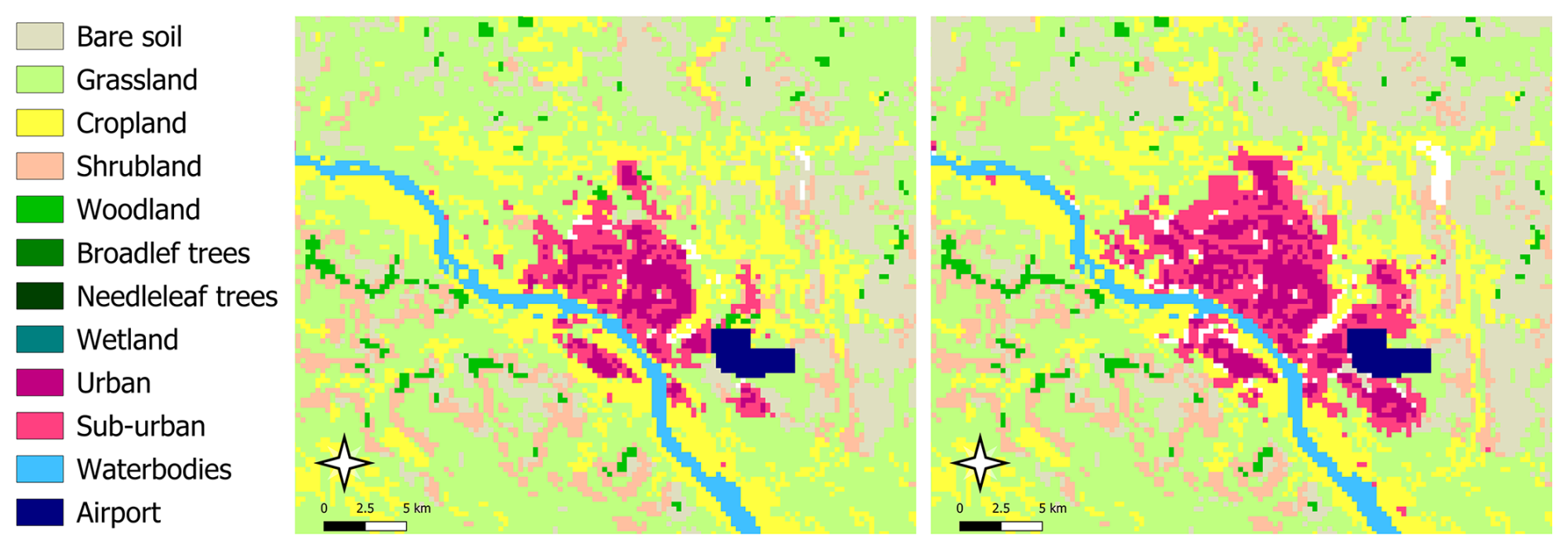
Figure 1Land-use maps of Niamey, Niger, for 2005 (left) and 2020 (right) at 300 m resolution, generated by integrating ESA CCI Land Cover, Global Human Settlement Layer built-up fractions, ESA WorldCover, and OpenStreetMap data. The comparison illustrates the urban growth of Niamey over just 15 years, which is exemplary of the rapid expansion seen in many African cities. (Contains modified Copernicus data 2020. © European Union, 1995–2024. Contains modified Copernicus data 2020. © OpenStreetMap contributors.)
The speed of urbanisation adds another layer of urgency, as can be seen from Fig. 1. Africa is projected to host some of the world's largest megacities by the end of this century (Hoornweg and Pope, 2017). Much of this growth is informal and unplanned, which increases exposure to hazards and limits adaptive capacity (Mukim and Roberts, 2023). This creates a triple risk: (1) the concentration of resources and people in cities, (2) structural vulnerability and limited adaptation options, and (3) urban features that amplify climate impacts. Despite these realities, fast-growing secondary cities in Africa remain substantially underrepresented in urban climate studies (Montfort et al., 2025).
Climate research in Africa has traditionally focused more on rural concerns, such as agriculture and water resources, than on urban challenges (Carr et al., 2020). Funding flows are also skewed, with most climate research funds directed to institutions outside Africa, leaving African researchers with limited resources to generate locally relevant knowledge (Overland et al., 2022). As a result, decision-relevant climate information at the city scale remains scarce, undermining efforts to support adaptation and limiting access to international climate finance.
Model-based climate information at the urban scale also remains limited. Global and regional climate models typically operate at spatial resolutions too coarse to capture city-level processes, creating a mismatch between research outputs and local adaptation needs (Graça et al., 2022; Hamdi et al., 2020).
Earth Observation (EO) provides an important complementary source of climate-relevant information, particularly in regions where ground-based monitoring networks are sparse, as in much of Africa. Satellite observations offer spatially consistent measurements of environmental conditions over large areas and multi-decadal time periods, enabling the analysis of land-cover change, urban expansion and surface temperature patterns at spatial resolutions of tens of metres (Li et al., 2022a; Wulder et al., 2019). Satellite-derived land surface temperature provides spatially distributed information on urban thermal patterns, with observations at different spatial and temporal resolutions offering complementary insights into urban thermal dynamics (Keramitsoglou et al., 2012). In recent years, the European Space Agency (ESA) and the Copernicus programme have substantially expanded the availability of such datasets through missions such as Sentinel and initiatives including the Climate Change Initiative (CCI) and the Global Human Settlement Layer (GHSL), which provide harmonised global information on land cover and urbanisation (Buchhorn et al., 2020; Melchiorri, 2022).
While these advances have improved the availability of climate-relevant data, important knowledge gaps remain regarding climate risks in African cities. African cities are growing rapidly while facing intensifying climate risks, but the knowledge base needed to support adaptation planning and financing remains underdeveloped.
Despite a growing body of literature on climate change in African cities, existing reviews have generally addressed specific aspects, including adaptation (Hunter et al., 2020), research trends (Mhedhbi et al., 2023), multi-risk perspectives (Fekete and Subramanian, 2024), or climate vulnerability and adaptation (Ansah et al., 2024). To the best of our knowledge, a broad, quantitative, hazard-centred synthesis across African cities remains lacking.
This study addresses this gap by synthesising what is currently known and unknown about climate risks in African cities. This is addressed through both quantitative and qualitative analyses of a sample of scientific publications on urban climate in Africa. The assessment follows a semi-systematic approach, combining automated procedures with expert evaluation of the literature. An overview of the data and methods is provided next, including the method used to establish the sample of scientific articles. Subsequently, results are presented stemming from quantitative and qualitative assessments, which are followed by the conclusions.
2.1 Selection of articles
Given the broad scope of the research question, the study was designed as a semi-systematic review (Snyder, 2019), combining quantitative mapping of the literature with qualitative thematic synthesis.
The initial step consisted of a selection of scientific articles in the Web of Science (WoS) archive records, using the set of keywords provided in Table 1. A final search update was conducted on 17 February 2026, focusing on the period 2015–2025, possibly entailing that some articles with a publication date in late 2025 might not be included yet.
The aim was to choose keywords in such a way as to keep as many avenues open as possible, i.e., keeping the restrictions limited to not miss potentially relevant articles. Still, in order to keep a sufficient and necessary focus, we demanded that variants of “urban” appear as a part of the title. The only topical keyword specified was “climat*” (to cover “climate”, “climatic”, “climatological”, etc.), i.e., we refrained from pre-defining topical terms referring explicitly to hazards such as heat, flooding, drought – or to methods, such as modelling, remote sensing – in order to avoid creating a bias from the start. Conversely, we specified the geographic context as completely as possible, both at the continental level (“Africa*”) and at the national level by including all 54 African country names, following the United Nations Department for General Assembly and Conference Management, according to which 54 countries belong to the African Group and are Members of the United Nations.
Table 1Keywords used for the selection of articles in the Web of Science records. The asterisk (“*”) denotes a wildcard. The “Topic” category contains the Title, Abstract, and Keywords.
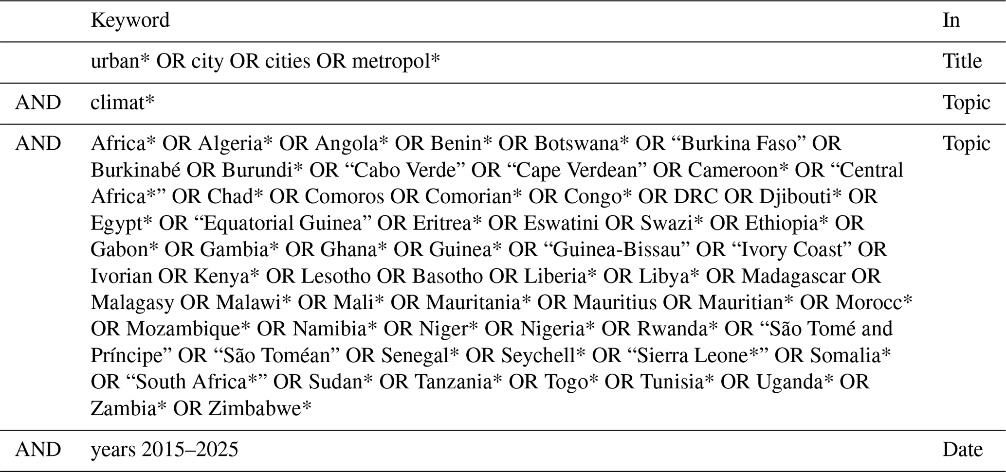
No explicit hazard-related terms (e.g. heat, flooding or drought) or methodological terms (e.g. modelling or remote sensing) were prescribed in advance. This was deliberate, as the hazards and methodological approaches represented in the literature were intended to be outcomes of the analysis. Prescribing such terms at the search stage would have required defining these categories a priori and could have biased their observed representation in the resulting corpus. A consequence of requiring climat* as a search term is that studies addressing individual urban hazards without explicitly referring to climate may not be retrieved. The resulting corpus therefore represents literature that explicitly connects hazards affecting African cities to a climate context, rather than the complete literature on urban hazards.
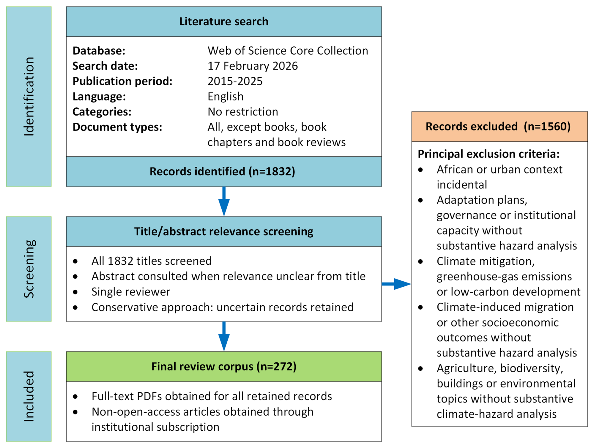
Figure 2Literature search and screening process used to identify the final review corpus. Records were identified through the Web of Science Core Collection and screened for title and abstract relevance according to the predefined inclusion and exclusion criteria. Of the 1832 records identified, 1560 were excluded, resulting in a final review corpus of 272 publications.
The literature search was conducted using the Web of Science Core Collection (state of 17 February 2026) and was restricted to English-language records published between 2015 and 2025. No restrictions were applied by Web of Science Category, and all document types were considered except books, book chapters and book reviews. The search returned a list containing 1832 records, which was subjected to manual relevance screening. Because the broad search deliberately omitted hazard-specific terms, a large proportion of the retrieved records were clearly outside the scope of the review, and the screening consisted primarily of removing these records (Fig. 2).
All titles were screened first, and where relevance could not be established from the title alone, the abstract was consulted. Records were retained where a climate hazard affecting an African urban setting constituted a substantive focus of the study. Records were excluded where the African or urban context was incidental, or where climate change or climatic hazards primarily provided context for another research topic without substantive analysis of the underlying hazard. Examples include studies focusing on urban crime or conflict following climatic shocks, climate-induced migration, adaptation planning and governance, greenhouse-gas mitigation, urban agriculture, building energy performance, and environmental issues such as pollution or waste management.
Screening was conducted by a single author. We considered this appropriate for our semi-systematic review because the broad search retrieved a large proportion of clearly out-of-scope records, making most exclusion decisions straightforward. Where relevance could not be established from the title alone, the abstract was consulted, and where uncertainty remained after consulting the abstract, the record was retained, this conservative approach being intended to minimize the risk of excluding potentially relevant studies. This screening procedure resulted in a final corpus of 272 articles. The bibliographic details of the articles constituting the final review corpus are provided as Supplement Material S1. Full-text PDFs were obtained for all papers retained in the final corpus, including through institutional subscriptions where articles were not openly accessible.
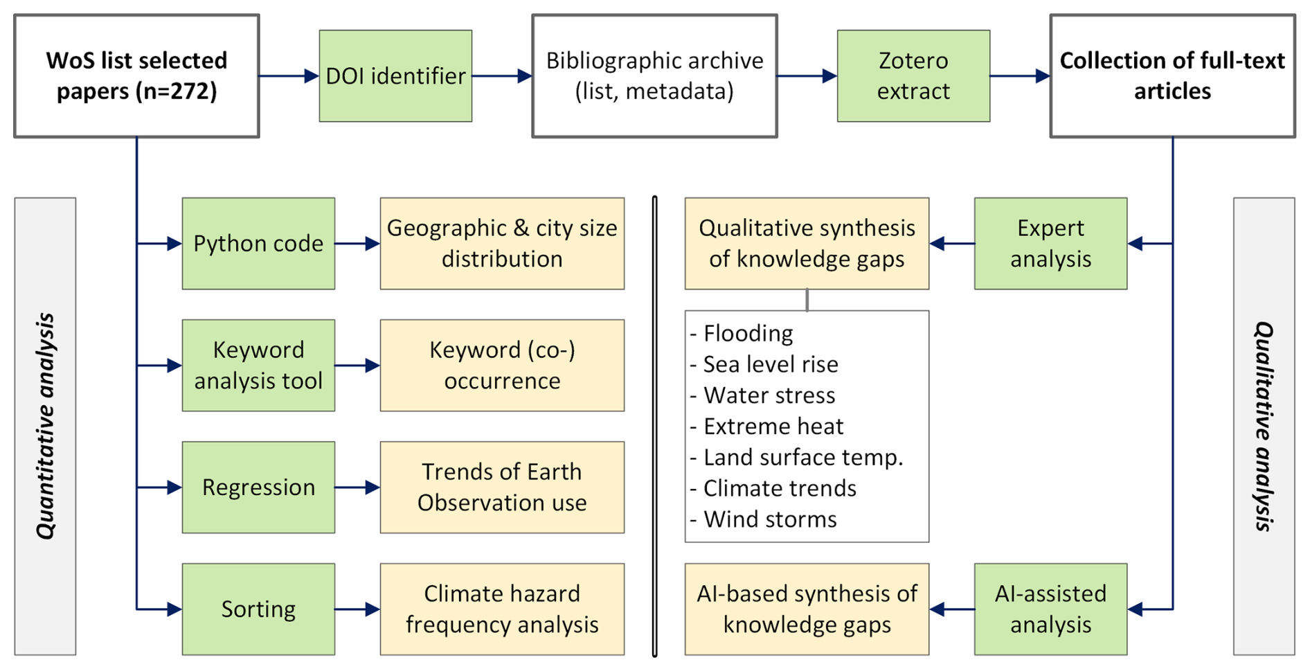
Figure 3Schematic representation of the analysis steps used in this article. The left half covers the quantitative analysis, the right half covers the qualitative analysis.
Applying the WoS “Analyse” function to the selected body of articles revealed that authors with an African affiliation account for 48.1 % in the sample. The countries contributing most to the publication record were found to be non-African (UK and US). The highest-ranking African countries in the sample were, in order, South Africa, Nigeria, Ethiopia and Ghana.
2.2 Brief overview of analysis steps
The method to conduct the analysis of the 272 selected articles is outlined in Fig. 3. The upper row of the figure shows, from left to right, the progression from the WoS export list towards bibliographic (Zotero) and PDF files-archive for each of the article records.
The WoS article list was analysed quantitatively with respect to (left half of Fig. 3)
-
the representativeness of the sampled cities in terms of (1) Köppen-Geiger climate zone and (2) population size;
-
keyword (co-)occurrence in the selected articles;
-
trends of Earth Observation (EO) use;
-
climate hazard frequency analysis.
The PDF archive containing all 272 articles was analysed qualitatively (right half of Fig. 3) by conducting an expert-based thematic analysis organised by climatic hazard.
3.1 Climate zone representation
The WoS list of 272 selected articles was examined for city names in the Title and Abstract fields by extracting all capitalised words from these texts, enabling rapid identification of potential city names. This was implemented in MS Excel using a Visual Basic for Applications (VBA) function that identifies and extracts words starting with a capital letter and stores them in a separate column.
This column was then reviewed to identify city names, by comparing city names occurring in the GHS Urban Centre Database (GHS-UCDB) R2024A from the Copernicus Global Human Settlement Layer (GHSL), which includes population estimates for each city (Melchiorri, 2022). If an extracted name from a selected article matched a city in the list, it was retained. If the same city had already been identified earlier, its occurrence count was increased by one. Nouns that resembled city names but were not present in the GHS-UCDB list were further checked using Wikipedia and Google Maps to determine whether they referred to neighbourhoods or sub-units of larger cities. In such cases, the names were assigned to the corresponding host urban agglomeration.
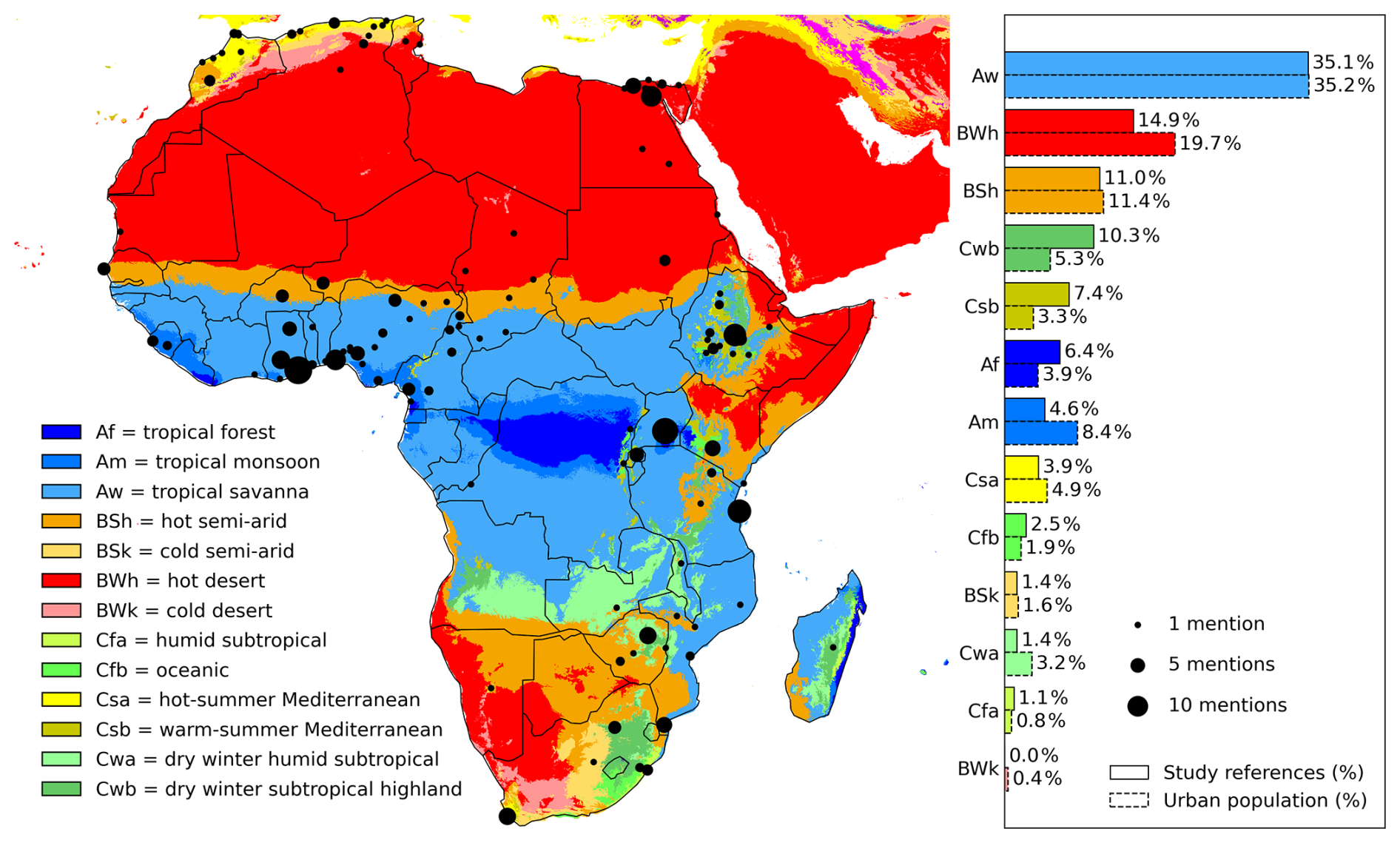
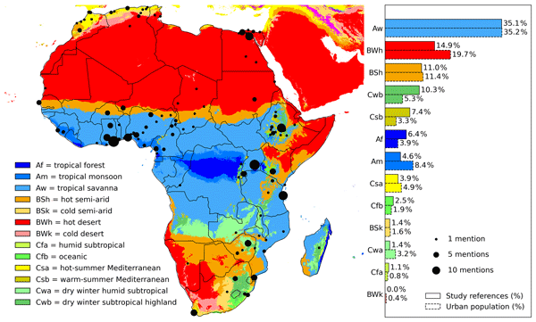
Figure 4Distribution of the reviewed literature across Köppen–Geiger climate zones compared with the baseline distribution of African urban populations. The bars representing the literature correspond to the number of reviewed articles referring to cities located within each climate zone. Cities may appear in multiple articles, so counts represent occurrences in the literature rather than unique cities. The baseline population distribution was derived from the GHSL Urban Centre Database (GHS-UCDB R2024A), aggregated by Köppen–Geiger climate (Beck et al., 2023). The comparison illustrates the extent to which research attention across climate zones reflects (or diverges from) the distribution of urban populations across Africa.
The analysis focused on urban agglomerations as defined in the GHS-UCDB list rather than on smaller units such as sub-cities or neighbourhoods. This choice was made for reasons of cross-country consistency, as the administrative subdivision of cities differs between countries. For example, a large city in one country may be recorded as a single entity, while in another it may be subdivided into multiple smaller administrative units.
The cities thus identified are shown in Fig. 4 as solid dots, scaled to the number of mentions (references) in the literature sample. For each of the cities, the Köppen-Geiger climate zone (Beck et al., 2023) was determined. This enabled a comparison of the frequency of climate zones represented in the literature sample with the baseline distribution of African urban populations across climate zones.
The comparison (Fig. 4) shows that the climate zones represented in the sample of urban climate studies reflect the actual distribution of African agglomerations rather well. The tropical savanna (Aw) zone, for instance, dominates both the literature sample and the population baseline.
Some imbalances are nevertheless apparent. Cities in highland (Cwb) and Mediterranean (Csa, Csb) climates receive disproportionately high attention relative to their urban population share, likely reflecting the visibility of climate impacts (e.g., flooding, landslides) and/or the presence of strong local research infrastructures. Conversely, urban populations in monsoon (Am), tropical forest (Af), and hot desert (BWh) climates are somewhat underrepresented, despite their demographic significance. These patterns highlight that while the overall distribution across climate zones is well captured, there remains a tendency for research to concentrate in hazard-prone or research-intensive regions, leaving important populations in other climate zones relatively less studied.
From a geographical point of view, Fig. 4 shows a relatively higher coverage of referenced cities (1) near the Gulf of Guinea (West Africa), (2) along an axis extending from East to Southern Africa, and (3) in North Africa along the Mediterranean. Such a pattern is consistent with findings by other researchers (Leal Filho et al., 2023; Montfort et al., 2025). From Fig. 4 it also emerges that a considerable number of the frequently studied cities are located along the coast.
3.2 City size representation
We compared the city size distribution (measured by number of inhabitants) of the city sample with the actual population distribution across different size categories:
-
small cities (<100 000 inhabitants)
-
medium-sized cities (100 000–1 000 000)
-
large cities (1 000 000–10 000 000), and
-
megacities (>10 000 000).
Figure 5 shows the distribution of the sampled cities (green bars) compared with the actual city size distribution (white bars). A most striking feature resides in the strong underrepresentation of small cities in the sample, whereas large cities are overrepresented. This lesser inclusion of smaller cities was also noticed by other researchers (Montfort et al., 2025). In contrast, medium-size and megacities are represented at proportions that closely match the actual distribution.
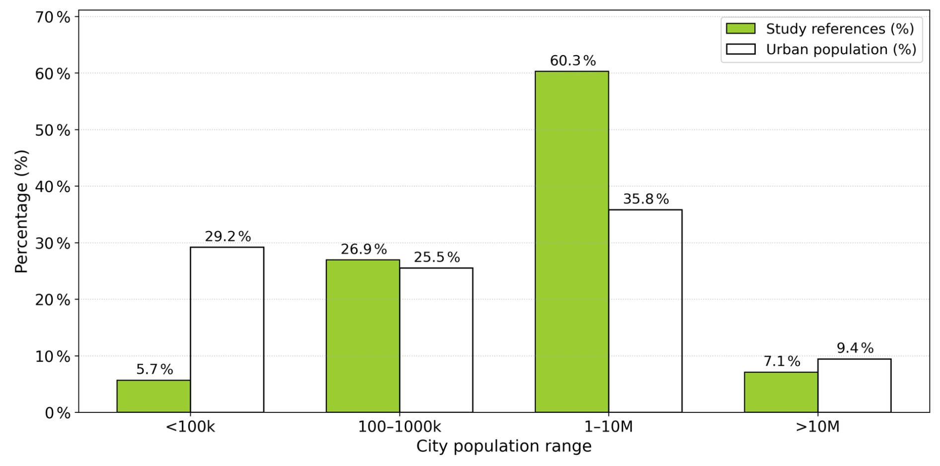
Figure 5Comparison of the proportion of study references (green bars) with the distribution of the urban population (outlined bars) across city population ranges in Africa.
We also examined the distinction between capital and non-capital cities in the sample. Out of 112 cities, 28 (25 %) are capitals. However, when weighting by the number of times each city is referenced in the selected articles (as represented by dot size in Fig. 4), the share of capital cities rises to nearly 45 %. This reflects the tendency for capital cities to appear in multiple studies, while smaller cities are typically mentioned only once.
3.3 Keyword (co-)occurrence analysis
A keyword analysis was conducted using VOSviewer, a software tool for constructing and visualizing bibliometric networks (http://www.vosviewer.com, last access: 21 October 2026) (Van Eck and Waltman, 2017). Using VOSviewer, a network map (Fig. 6) was created from the bibliographic data contained in the WoS output file, based on a co-occurrence analysis of both author keywords and Keywords Plus.
The terms “climate (change)” and “urban/city” were excluded from the keywords, given they were the primary search keywords (hence should not re-appear on the network map). Our focus was on identifying additional keywords that emerged from the search. To reduce clutter and avoid less relevant terms, only keywords appearing at least nine times were retained, resulting in a final list of 47 keywords. This threshold of 47 was determined through trial and error, aiming for a balance between including as many relevant terms as possible while maintaining a clear visualization. A VOSviewer “thesaurus” file (see Van Eck and Waltman, 2017) was developed and applied to (1) filter out non-relevant keywords (e.g., city names); (2) merge spelling variants (e.g., “heat island” vs. “heat-island”); (3) unify conceptually similar terms (e.g., “earth observation” and “remote sensing”).
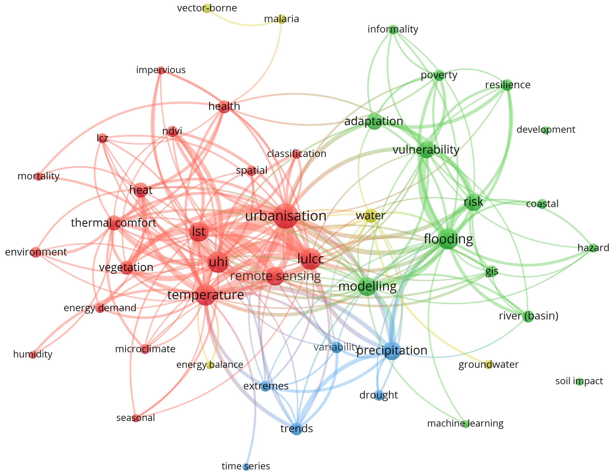
Figure 6Keyword co-occurrence network generated with VOSviewer. Colours indicate clusters of related keywords, and the thickness of connecting lines reflects the frequency of co-occurrence. Larger nodes represent keywords that appear more frequently across the dataset. For layout reasons, some keywords are abbreviated: “ndvi” = normalized difference vegetation index; “lst” = land surface temperature; “uhi” = urban heat island; “lulcc” = land use/land cover change; “lcz” = local climate zone.
For visualization, the VOSviewer Scale parameter was set to 100 %, fully allowing circle sizes to reflect keyword frequency (larger circles representing more frequent keywords); the Size Variation parameter was set to 50 %, in order to avoid excessively small labels for less frequent keywords. Figure 6 shows the keyword co-occurrence network generated by VOSviewer. Node size reflects the frequency of keyword occurrence, while the thickness of the connecting lines indicates the strength of co-occurrence. Colours represent clusters, the algorithm positioning related terms closer together to reveal strong internal relationships. The occurrence and connectivity of keywords is also provided as a ranked table in Supplement Material S2, including keyword occurrence frequencies and Total Link Strength (TLS) values.
In Fig. 6, four clusters emerge. The red cluster is dense and cohesive around heat-related terms: UHI (urban heat island), LST (land surface temperature), and thermal comfort). Here, LST refers to the radiative temperature of the Earth's surface, as inferred from emitted thermal radiation, and is distinct from near-surface air temperature. The green cluster centres on flooding and social aspects (risk, vulnerability, poverty). Smaller clusters focus on hydrological extremes (blue) and water- and health-related issues (yellow).
Several nodes occupy central positions in the network, bridging across clusters: these include urbanisation, remote sensing, LULCC (land use/land cover change), and modelling. Unlike hazard-specific terms such as heat or flooding, these concepts represent methodological tools or overarching processes that naturally connect different research areas. For instance, remote sensing is strongly tied to land surface temperature (LST), urban heat island (UHI), and urbanisation in the red cluster but also links to flooding and land-use studies. Modelling serves as another methodological bridge, connecting the flooding and vulnerability literature with research on precipitation and variability.
Peripheral nodes represent less frequent or more isolated keywords. Strikingly, many of these are impact-related, such as mortality, vector-borne disease, malaria, or the aggregated term soil impacts (covering landslides, soil erosion, and subsidence). Broader socio-economic dimensions like poverty, informality, and hazard also appear in the periphery. Their position suggests that explicit links to concrete societal impacts remain less developed and relatively fragmented. Emerging methodological terms, such as machine learning, are also visible at the margins, indicating directions that are beginning to enter the field but have not yet reached central importance.
Taken together, Fig. 6 demonstrates that hazard-specific research (e.g., heat, flooding) forms the structural backbone of the network, while methodological concepts such as remote sensing and modelling provide essential connections across themes. At the same time, the peripheral position of impact-related keywords highlights a gap in the literature: despite frequent references to hazards and methods, systematic integration of health, poverty, and other vulnerability dimensions into the research is still relatively limited. This suggests an important direction for future work, namely the stronger linkage of urban climate hazard research to the societal impacts most directly affecting populations.
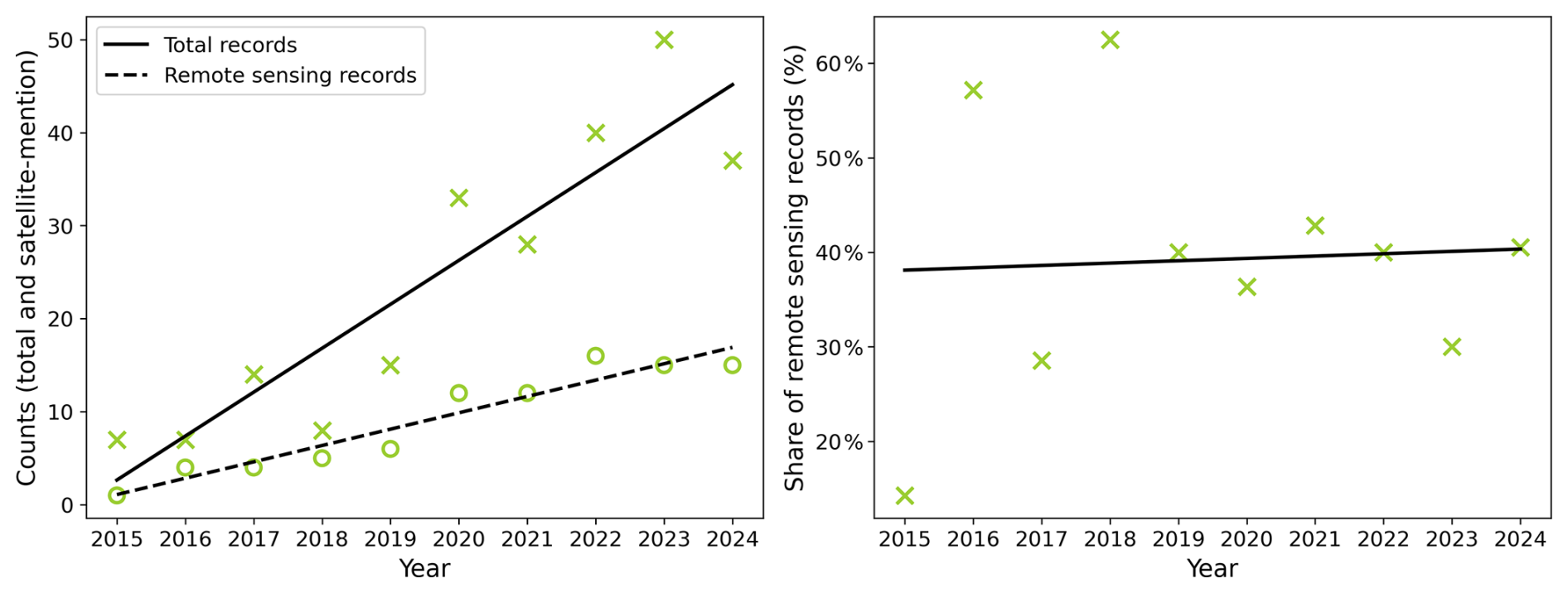
Figure 7Left: total number of articles (crosses and solid regression line) and EO-using articles (circles and dashed regression line) published per year throughout the period 2015–2024. Right: share of the number of EO using articles (crosses and solid regression line).
3.4 Trends of EO data use
Considering that Earth Observation (EO) constitutes a rapidly evolving field, the selected articles were analysed with respect to the trend of the use of EO data. The regression was done over the time span 2015–2024, i.e., excluding articles published in 2025 as that might not be complete (the sampling of the 2015–2025 articles having been finalised in February 2026), which could introduce a bias.
The total annual output of articles shows a clear upward trend over the period 2015–2024 (Fig. 7, left), increasing from only a few articles in 2015 to more than 40 in 2024. The number of studies using satellite remote sensing similarly increases over this period. In contrast, the relative share of remote-sensing studies varies substantially during the first years of the period but remains relatively stable at around 40 % in the later years (Fig. 7, right). This indicates that, while the absolute number of studies using remote sensing has increased alongside the overall growth of the literature, its proportional contribution to the field has not markedly increased in recent years.
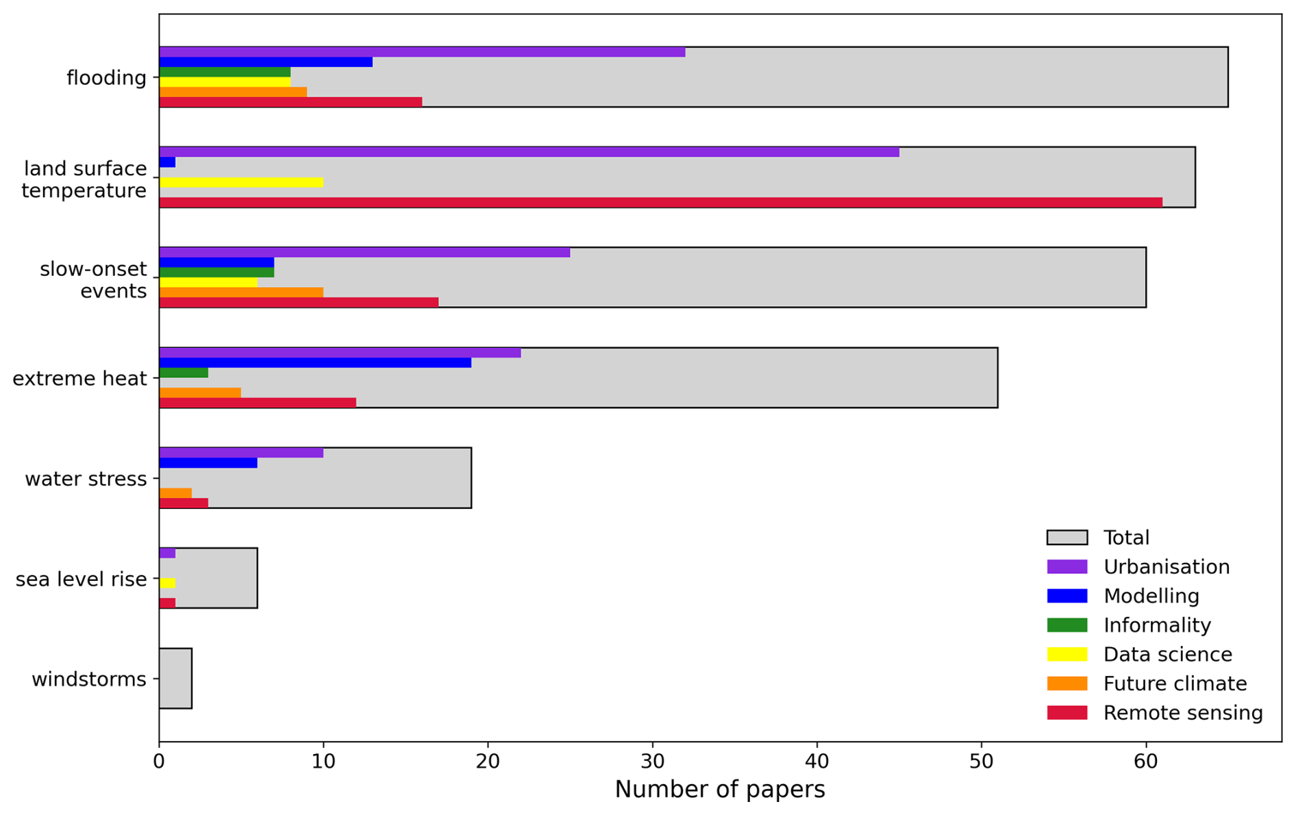
Figure 8Distribution of reviewed articles across different hazard types. Grey bars show the number of articles for each hazard, while coloured bars indicate the occurrence of methodological/contextual themes (urbanisation, modelling, informality, data science, future climate, and remote sensing). In this figure, “LST” refers to land surface temperature. “Modelling” refers to deterministic climate or hydrological modelling, and “Data Science” refers to artificial intelligence, machine learning, deep learning, etc.
3.5 Climate hazard frequency
The list of 272 articles was further analysed in terms of the climate hazards covered. This was done by experts in the respective hazard domains, screening the title and abstracts of each article, labelling them with a hazard indication, including windstorms, sea level rise, water stress, extreme heat, slow-onset events, land surface temperature (LST), and flooding. Here, slow-onset events refer to gradual changes in climatic conditions, such as increasing mean temperatures or changing precipitation patterns, consistent with the IPCC framing of slow-onset events (Calvin et al., 2023).
In cases where an article covered multiple hazards, the dominant hazard was identified, obviously inducing a certain level of subjectivity. In addition, each article was labelled for the occurrence of (or reference to) one or more conceptual or methodological aspects, including urbanisation (including such terms as urban growth, or urban dynamics), modelling, informality, data science, future climate, remote sensing.
The outcome of this exercise is shown in Fig. 8. A close look at the distribution of hazards reveals clear thematic imbalances. Research on flooding and LST dominate the field, together accounting for nearly half of all publications. Studies on slow-onset events and extreme heat are also well represented, underlining the importance of both gradual climate variability and acute heat extremes in African cities. It is worth noting that the two heat-related categories (extreme heat and LST) were separated in our classification. While this provides analytical clarity, it may also dilute the apparent weight of heat-related hazards in the dataset: taken together, these account for well over a hundred articles, confirming heat as one of the most prominently studied urban climate risks in Africa. The prominence of land surface temperature in particular reflects the reliance on remote sensing, which offers a consistent and widely accessible data source in data-sparse regions such as Africa. By contrast, water stress, sea level rise, and windstorms are covered only sparsely, despite their known relevance for urban vulnerability. This thematic skew suggests a concentration of research attention on hazards that are both visible in cities and relatively straightforward to monitor, while other critical but less studied risks remain underexplored.
In addition to classifying articles by their dominant climate hazard, we also identified several recurring methodological and contextual themes that characterise how climate risks in African cities are studied. These include urbanisation processes (urban growth and land-use change), deterministic modelling approaches (e.g., urban climate or hydrological models), Earth Observation, and data science techniques such as artificial intelligence and machine learning. We further assessed whether studies explicitly consider future climate projections and whether they address urban informality, a key structural feature influencing exposure and vulnerability in many African cities.
Analysing Fig. 8 in terms of these conceptual and methodological aspects reveals a host of information:
-
Remote sensing data is used in a minority (10 %–20 %) of studies, except within the land surface temperature (LST) topic, for obvious reasons. A deeper analysis showed that most literature cases made use of Landsat imagery, either to observe patterns of land surface temperature, or to assess historical urban growth.
-
Urbanisation, urban growth or urban dynamics is mentioned in nearly half of the articles, yet nearly all of these have a historical focus, i.e., they consider past urban growth; only 10 (out of 272) articles concern forward-looking urban growth studies.
-
The use of artificial intelligence (AI), machine learning (ML) and similar techniques is limited, while these could offer a way to overcome scaling challenges as well as challenges of access to computational infrastructure for African researchers.
-
Most studies focus on historical or present-day climate periods; relatively few (order 10 %) consider future climate projections.
-
Deterministic modelling (urban climate and hydrology) is used to a limited extent only; studies often interpolate climate data from coarse model output fields, thus ignoring the local impact of the urban fabric on its own microclimate (e.g., urban heat island).
-
Considerations of informality remain limited, being mentioned in less than 10 % of the selected articles.
3.6 Cross-hazard representation
To complement the dominant-hazard classification, papers were additionally screened for substantive consideration of other hazard categories. Titles and abstracts were examined, with the full text consulted when necessary. Merely incidental references to other hazards were not counted.
The recorded dominant and additional labels indicated consideration of more than one thematic category in 30 papers (11 %).
A more detailed analysis shows that the cross-hazard nature differs between the themes:
-
Slow-onset studies can encompass several distinct hazards within a broader assessment of climatic change and its impacts. For example, research in Pietermaritzburg examines how drought, heatwaves, floods and other climate stressors affect urban livelihoods and coping capacities (Hlahla and Hill, 2018).
-
Extreme heat and LST overlap within assessments of urban thermal conditions and vulnerability. In Johannesburg, for example, LST and other environmental indicators are combined with socioeconomic and health variables to assess heat vulnerability (Parker et al., 2025). However, this represents complementary information rather than distinct hazards.
-
Flooding and sea-level rise are connected through coastal water levels and drainage conditions. Research in Maputo explicitly examines rainfall–tidal compound flooding and its implications for storm drainage performance (Matos et al., 2023).
-
Water stress and flooding can be considered together through both hazard assessment and adaptation measures. Research in Ethiopia assesses urban water availability alongside drought and flood exposure (Abraha et al., 2022). In Beira, rainwater harvesting is examined as a means of reducing demand on municipal water supplies while potentially reducing stormwater flows and urban flooding (Santos et al., 2023).
-
Windstorm research can address flooding and storm surge (Williamson et al., 2023).
Some papers explicitly examine distinct hazards within a shared urban context. For example, two studies in Accra and Tamale address flooding and extreme heat and their impacts on healthcare provision and on water and electricity services (Codjoe et al., 2020; Kayaga et al., 2021). Consideration of multiple hazards should be distinguished from analysis of compound or cascading processes. A clear example of compound-hazard analysis is provided by the Maputo study, which examines the combined influence of rainfall and tidal conditions on urban flooding (Matos et al., 2023).
The bibliometric analysis presented in Sect. 3 reveals clear patterns in the thematic focus of the literature on climate risks in African cities. In the following section, we complement this quantitative overview with a qualitative synthesis, with the aim of describing the current state of the art and identifying scientific knowledge gaps. The qualitative analysis consists of (1) a meta-review based on a small number of recent review articles and (2) expert-based thematic reviews organised by hazard type as identified in Fig. 8. An exploratory AI-assisted comparison was additionally conducted and is described in Supplement S3; its results were not used as an independent basis for the conclusions of this review.
4.1 Meta-review
A few recent review studies provide important context for understanding recent urban climate research in Africa. These include systematic mapping of adaptation responses (Hunter et al., 2020), bibliometric analyses of research trends (Mhedhbi et al., 2023), thematic assessments of urban thermal change (Li et al., 2022b), emerging multi-risk perspectives (Fekete and Subramanian, 2024), and broader scoping reviews of urban climate risk and governance (Ansah et al., 2024). Together, these review articles describe a rapidly expanding but unevenly developed knowledge base.
A consistent finding is the strong growth in publications since the mid-2010s (Mhedhbi et al., 2023). However, research remains geographically concentrated. A limited number of countries – particularly South Africa, Nigeria, Kenya, Egypt and Ghana (also see the findings of Sect. 2.1) – account for a disproportionate share of studies, while large parts of Central Africa and many secondary cities remain sparsely represented (Hunter et al., 2020; Mhedhbi et al., 2023). Capital cities and economically prominent agglomerations dominate the record.
Thematically, heat and flooding receive substantial attention within the urban climate literature, reflecting their relevance for African cities. Flooding is frequently examined through hydrological modelling, exposure assessments and spatial analyses (Hunter et al., 2020). Heat-related research often focuses on land surface temperature and urban heat island characteristics derived from satellite data (Li et al., 2022b). Other hazards, such as windstorms, coastal flooding and water stress, appear less consistently across the literature. Also, even though calls for integrated multi-hazard perspectives are increasing (Fekete and Subramanian, 2024), most studies still address hazards in isolation.
Methodologically, the literature combines Earth Observation, spatial analysis and a range of modelling approaches. While these methods present substantially improved spatial diagnostics in data-scarce environments, high-resolution urban climate modelling and physically detailed representations of urban processes remain limited (Fekete and Subramanian, 2024; Li et al., 2022b). Explicit coupling of hazard, exposure, vulnerability and adaptive capacity is comparatively uncommon (Ansah et al., 2024; Hunter et al., 2020). Although social dimensions (poverty, informality, governance capacity and inequality) are frequently acknowledged, they are less often incorporated into quantitative risk assessments.
Forward-looking assessments also remain limited. While some studies employ downscaled climate model outputs, very few integrate future climate scenarios with projected urban growth, demographic change or adaptation pathways (Fekete and Subramanian, 2024; Li et al., 2022b). As a result, the literature provides important diagnostics of present-day patterns but offers fewer insights into long-term urban transformation under climate change.
In contrast to the reviews discussed above, the present study takes a hazard-centred perspective and explicitly quantifies the representativeness of the literature. In particular, research coverage is compared with the distribution of African urban populations across climate zones and city-size classes, alongside an assessment of methodological characteristics, including the use of Earth Observation and modelling.
4.2 Expert-based thematic reviews
In the following subsections, the selected articles – organised by hazard type as occurring in Sect. 3.5 – were assessed by thematic experts. The length and level of detail of the subsections vary according to the scope and characteristics of the literature identified for each hazard. Rather than providing an exhaustive study-by-study account, the discussion focuses on synthesising the main insights emerging from the reviewed literature for each hazard. Section 4.3 brings these findings together in a synoptic table, providing a concise synthesis across the different hazard themes.
4.2.1 Flooding
Flooding is a major urban hazard across Africa (Douglas, 2017), with climate change reshaping important hydroclimatic drivers, particularly intense rainfall. Rather than being expressed only through higher annual totals, these changes can involve sharper sub-daily rainfall bursts and shifts in seasonality (Bulti et al., 2021), increasing the likelihood of short, intense storms and making historical intensity–duration–frequency relationships less reliable for design in affected regions (Padji et al., 2024). In coastal settings, heavy rainfall can also coincide with high tides or cyclone-driven surges, amplifying backwater effects at drainage outfalls (Matos et al., 2023). Taken together, these studies indicate that changing rainfall characteristics and, in coastal cities, interactions with marine conditions can alter the magnitude and timing of urban flood hazard.
However, the literature also shows that worsening urban flooding cannot be attributed to changing climate conditions alone. New climate stresses interact with scarce natural storage and undersized or poorly maintained drainage systems (Lameche et al., 2023). while rapid and often unplanned urban growth compounds persistent infrastructure and maintenance gaps (Beshir and Song, 2021). Expansion into floodplains and wetlands simultaneously increases exposure and impervious cover while removing natural surfaces that previously slowed runoff (Andreasen et al., 2023), and encroachment into drainage rights-of-way can further concentrate overland flow at hydraulic constrictions. Urban flood impacts therefore emerge from the interaction between changing rainfall, land-use change and drainage performance, rather than climate exposure alone (Neves et al., 2023).
This interaction between hazard, exposure and vulnerability is also evident in the socioeconomic consequences of flooding. Impacts on households and businesses are most severe where low-lying exposure overlaps with social vulnerability and weak infrastructure (Kita, 2017; Zehra et al., 2019). Accordingly, the literature considers operational measures alongside physical infrastructure upgrades, including pre-storm inlet clearing, removal of bottlenecks, protection of drainage rights-of-way and timely local warnings (Dumedah et al., 2021), Where mapped flow paths and documented constraints are available, prioritised maintenance and selective upsizing can reduce inundation and service interruptions more effectively than uniform area-wide retrofits (Miller et al., 2022; Tedla et al., 2022). The literature thus links the effectiveness of flood-risk reduction not only to additional infrastructure, but also to how existing drainage systems are maintained, targeted and operated in relation to local exposure and vulnerability.
Despite the urgency of these challenges, capacity to track and plan for changing flood patterns still lags in many regions (Boko et al., 2020). Sparse or outdated sub-hourly rain gauges, river and tide-level loggers and drainage inventories hamper both detection of changes in short-duration extremes and routine updating of design assumptions, while consistent event-based datasets linking rainfall, inundation, losses, affected services and intervention performance remain rare. Spaceborne Earth observation and artificial intelligence offer ways to address data scarcity and model-flexibility challenges (Ekwueme, 2022; Weday et al., 2023), but ground validation and open, maintained asset maps remain necessary at city level. Consequently, data limitations affect not only flood characterisation but also the transferability of approaches between cities, reinforcing the need for sustained comparative research to translate changing hazard evidence into adaptive design standards and maintenance and upgrade programmes (Hassan et al., 2022).
4.2.2 Sea level rise
Another important consequence of climate change is sea-level rise (SLR), which is raising the baseline for coastal flooding and increasing the occurrence of coastal extremes along African coastlines. The resulting hazard is often compound: when intense rainfall coincides with high tides or storm surges, reduced freeboard and higher tailwater levels at drainage outfalls can impede drainage and turn storms that would previously have remained below street-flood thresholds into disruptive inundation. This risk is particularly pronounced in embayments, back-beach lagoons and river deltas, where shallow slopes and constricted outlets amplify backwater effects, as illustrated by the vulnerability of the Nile Delta (Abdrabo et al., 2022; Kamal et al., 2025). The literature thus presents SLR not simply as gradual coastal inundation, but as an increasing baseline that can amplify existing rainfall, tidal and drainage-related flood processes. Nevertheless, vulnerability is highly location-specific, making locally resolved assessment essential (Halecki and Bedla, 2025).
The effects of SLR are further shaped by structural characteristics of African coastal cities. Low-lying topography, constrained drainage outlets, maintenance backlogs and the concentration of critical services along shorelines all increase vulnerability to compound coastal flooding (Yankson et al., 2017). Rapid urban growth is particularly important in the African context (Noby et al., 2024), as the removal of natural buffers and urban growth-related land subsidence can compound relative sea-level rise and extend its effects into beach and wetland areas. Taken together, these studies show that urban vulnerability to SLR is produced by the interaction of rising coastal water levels with urban development, drainage and infrastructure conditions, and the degradation of natural coastal protection. Addressing these interacting risks requires stronger coastal hydro-climatological monitoring and better integration of available data, for which Earth Observation products offer a viable approach in the region. In the shorter term, the literature supports measures such as updating hazard zoning and identifying priority areas for drainage improvement (Halecki and Bedla, 2025). The central research challenge is therefore to translate improved monitoring and modelling of a broadly shared hazard into locally specific assessments.
4.2.3 Water stress
Water stress in African cities is a coupled supply–demand problem: climate variability can disrupt freshwater availability while rapid population and urban growth increase demand (Dos Santos et al., 2017). On the supply side, longer droughts and dry spells can reduce river flows, reservoir storage and aquifer recharge (Gumbo and Kapangaziwiri, 2023; Rusca et al., 2023). Even where changes in annual rainfall are modest, shifts in rainfall timing and longer hot spells can increase the risk of supply outages (Ayanlade, 2024). The literature therefore indicates that urban water stress depends not only on the total amount of water available, but also on the timing and reliability of supply relative to growing demand.
On the demand side, population growth and urbanisation are increasing city-wide water requirements, while associated land-cover changes and limitations in service provision influence how severely households experience water shortages (Foster and Gathu, 2024). Where utilities cannot meet demand, households may turn to private boreholes and water vendors, but these responses can accelerate groundwater drawdown, increase salinity and contamination risks, and impose higher costs on poorer areas (Oiro et al., 2020; Shiru et al., 2020). Water stress is therefore also shaped by the capacity of urban water systems to accommodate rising demand: responses to inadequate formal provision can themselves create additional pressures on groundwater resources and uneven socioeconomic burdens.
Work on Marrakesh illustrates how these interconnected pressures on water resources and services can generate water stress in contrasting urban contexts (Analy and Laftouhi, 2021). In both cases, urban expansion has increased water demand, while encroachment on recharge areas and wetlands has reduced groundwater recharge. Together, these cases reinforce the central finding that urban water stress emerges from interacting climatic, demographic, land-use and service pressures rather than from water availability or climate variability alone.
4.2.4 Extreme heat
Observational studies provide evidence of changing historical trends in heatwave characteristics in African cities. In Ghana, for example, heatwaves have become more frequent, especially at night, while large differences are found between cities (Wemegah et al., 2025). Analysis for Mozambique also finds increases in heatwave frequency and duration across many parts of the country, including urban areas, although the magnitude of these trends depends strongly on how heatwaves are defined, for example using maximum temperature, minimum temperature, or the compound Excess Heat Factor (Pereira Marghidan et al., 2023). Enhanced nighttime heatwaves have also been identified across African urban clusters, pointing towards nighttime conditions as a specific component of urban heat hazard (Igun et al., 2023). Taken together, these studies provide evidence of changing heatwave characteristics, but the diversity of heatwave definitions complicates comparison between studies and cities.
Future urban heat projections constitute another recurring topic in the examined articles. However, while several studies project increasing heat under climate change, only a few include the effect of urban growth, which is projected to be very high in Africa (see the Introduction). Detailed work in Niamey based on the UrbClim-GeoDynamiX modelling suite illustrates the value of coupling urban climate modelling with projected urban expansion: future heat stress increases both in intensity and spatial extent as the city grows (Souverijns et al., 2023). This distinction is important because projecting a changing climate over a static representation of the city may overlook this additional influence of urban expansion. Even where future land-cover change is modelled, its feedback on local climate is not always represented. For example, in Lomé and Kara, projected land-cover and vegetation changes are combined with interpolated large-scale temperature and precipitation changes, rather than dynamically coupled to a local climate model (Deton et al., 2025). The literature therefore indicates that future urban heat projections remain limited by the extent to which urban growth and its feedback on local climate are represented.
The importance of accounting for urban changes and overall urban morphological characteristics is supported by studies of present-day and historical urban development. Modelling for Kampala demonstrates that urbanisation modifies local climate, interacting with regional atmospheric processes (Brousse et al., 2020b). High-resolution simulations in Lagos identify substantial spatial differences in heat stress associated with urban morphology (Obe et al., 2024). At finer scales, measurements in Kampala (Van De Walle et al., 2022) and modelling in Johannesburg (Souverijns et al., 2022) show that these differences lead to strongly varying outdoor heat exposure between neighbourhoods, with particularly high exposure in dense settlements with little vegetation. Microscale measurements in Akure also demonstrate the cooling effect of tree shading on outdoor thermal conditions (Morakinyo et al., 2016). However, a multi-city analysis shows that green space cooling efficiency varies with regional meteorological conditions (Cheng et al., 2022). Overall, the evidence demonstrates that urban form and vegetation substantially modify outdoor heat, but that these effects vary both within and between cities.
Research on exposure to extreme heat and its impacts appears more limited. The corpus shows little direct evidence on indoor heat exposure, apart from an article on measurements in low-income communities in Ghana showing that indoor temperature extremes are strongly influenced by housing characteristics (Wilby et al., 2021). Health impacts are also addressed in only part of the examined articles, e.g. one epidemiological study examined the association between temperature and years of life lost in informal settlements in Nairobi (Egondi et al., 2015). Energy impacts receive somewhat more attention: in Sfax, urban heat and thermal discomfort are related to electricity consumption during the hot season (Ghribi and Dahech, 2023), and work in Morocco examines the combined effects of climate variation and urban expansion on building energy demand (Zhao et al., 2025). Overall, the heat hazard itself is more extensively characterised than human exposure and its consequences.
4.2.5 Land surface temperature
Land Surface Temperature (LST) is the radiometric “skin” temperature retrieved from longwave thermal infrared emission by satellite sensors, representing the thermal state of the uppermost surface layer. Unlike near-surface air temperature, LST is governed by surface emissivity, morphology and energy balance. Although correlated with air temperature, it captures a distinct component of the urban heat system and provides a spatial expression of how the physical characteristics of cities influence surface heating (Li et al., 2022b).
In African contexts, where meteorological station networks are sparse and unevenly distributed, satellite-derived LST has become important for diagnosing urban thermal dynamics. The Landsat archive enables multi-temporal observation of surface thermal change at neighbourhood scale and allows these changes to be examined alongside urban land-cover transformation (Arsiso et al., 2018; Tarawally et al., 2018). Across the reviewed studies, urbanisation and land-use and land-cover change emerge as important drivers of the spatial distribution of surface heat: built-up and impervious surfaces are associated with higher LST, while vegetation and water generally moderate surface temperatures (Gyimah, 2023; Koko et al., 2021; Odindi et al., 2022). Accordingly, satellite-based studies identify persistent surface hot zones particularly within built-up urban areas (Gyimah, 2023; Melese et al., 2025). Collectively, this evidence links the spatial pattern of surface warming strongly to the transformation and composition of the urban surface.
Research has increasingly moved beyond mapping these patterns towards explaining their spatial differentiation. The Local Climate Zone (LCZ) framework supports this shift by classifying urban areas according to surface cover, structure and material characteristics, allowing LST variability to be related more systematically to different urban forms (Tarawally et al., 2018). Vegetated and blue–green surfaces are generally associated with lower LST, although urban structure mediates the magnitude of this cooling effect (Athukorala and Murayama, 2020; Li et al., 2022c). The literature thus increasingly connects where surface heat occurs with the urban characteristics that help produce or mitigate it.
This spatial differentiation also provides a basis for examining vulnerability. Densely built, vegetation-poor neighbourhoods with elevated surface temperatures can coincide with lower-income populations, creating spatial concentrations of heat vulnerability (Mushore et al., 2017). LST does not directly measure human heat exposure, but its high spatial resolution allows surface thermal conditions to be combined with demographic and socioeconomic indicators. Incorporating remotely sensed surface characteristics into machine-learning approaches can further support urban hazard and vulnerability mapping (Dufitimana et al., 2025; Mushore et al., 2019). LST research therefore increasingly uses spatial patterns of surface heat to identify potentially vulnerable areas, while recognising that LST does not directly measure human heat exposure.
4.2.6 Slow-onset events
Climate change impacts are often most visible through sudden extreme events, such as extreme precipitation leading to floods. However, many climate-related consequences develop over longer periods and are perceived only gradually.
One important long-term impact concerns vector-borne diseases. Climate change can expand areas suitable for disease vectors, potentially increasing the population exposed. Most studies focus on malaria (Brousse et al., 2020a; Kamkuemah et al., 2024) and dengue (Osalla et al., 2025), while less research is present on yellow fever (Aliaga-Samanez et al., 2024), zika and chikungunya (Montgomery et al., 2025). Vector suitability is assessed using different methodologies, including climate modelling, remote sensing, Local Climate Zones (LCZs) and GIS mapping. Importantly, the literature increasingly places climatic suitability within a broader urban context: rather than considering climate effects in isolation, multidimensional approaches account jointly for future urbanisation, climate change and their implications for vector-borne disease (Rose et al., 2020).
Rapid urbanisation is an important component of these longer-term changes in African cities, with the urban population expected to approximately double between 2025 and 2050, from around 700 million to almost 1.5 billion (UN-Habitat, 2022). Conversion of natural land as cities expand and densify modifies local temperature, humidity and rainfall. These urban–atmosphere interactions are investigated using high-resolution climate models (Anande and Park, 2021; Zeleke et al., 2023), remote sensing (Frimpong et al., 2022; Traore et al., 2025) or ground-based observations (Kabano et al., 2022), with the advantages and limitations of these methods documented elsewhere (Souverijns et al., 2023). Downstream research addresses health impacts associated with higher temperatures and their different drivers (Codjoe et al., 2020; Rother, 2020), often highlighting unequal impacts within cities. Informal settlements and slums are of particular concern because of limitations in both monitoring and adaptive capacity (Corburn et al., 2022; Damte et al., 2023). Together, these studies show that urbanisation is not only a source of increasing exposure, but also modifies local climatic conditions and the distribution of associated health risks within cities.
Urban expansion also affects ecosystems and biodiversity. The loss of natural ecosystems, habitats and green cover as cities grow reduces resources that contribute to urban climate resilience. Nature-based solutions are consequently proposed to restore urban biodiversity while also supporting adaptation to other climate-related impacts (Abraha et al., 2022). This literature therefore connects ecosystem loss and climate adaptation: the same natural systems affected by urban expansion can also contribute to resilience when maintained or restored.
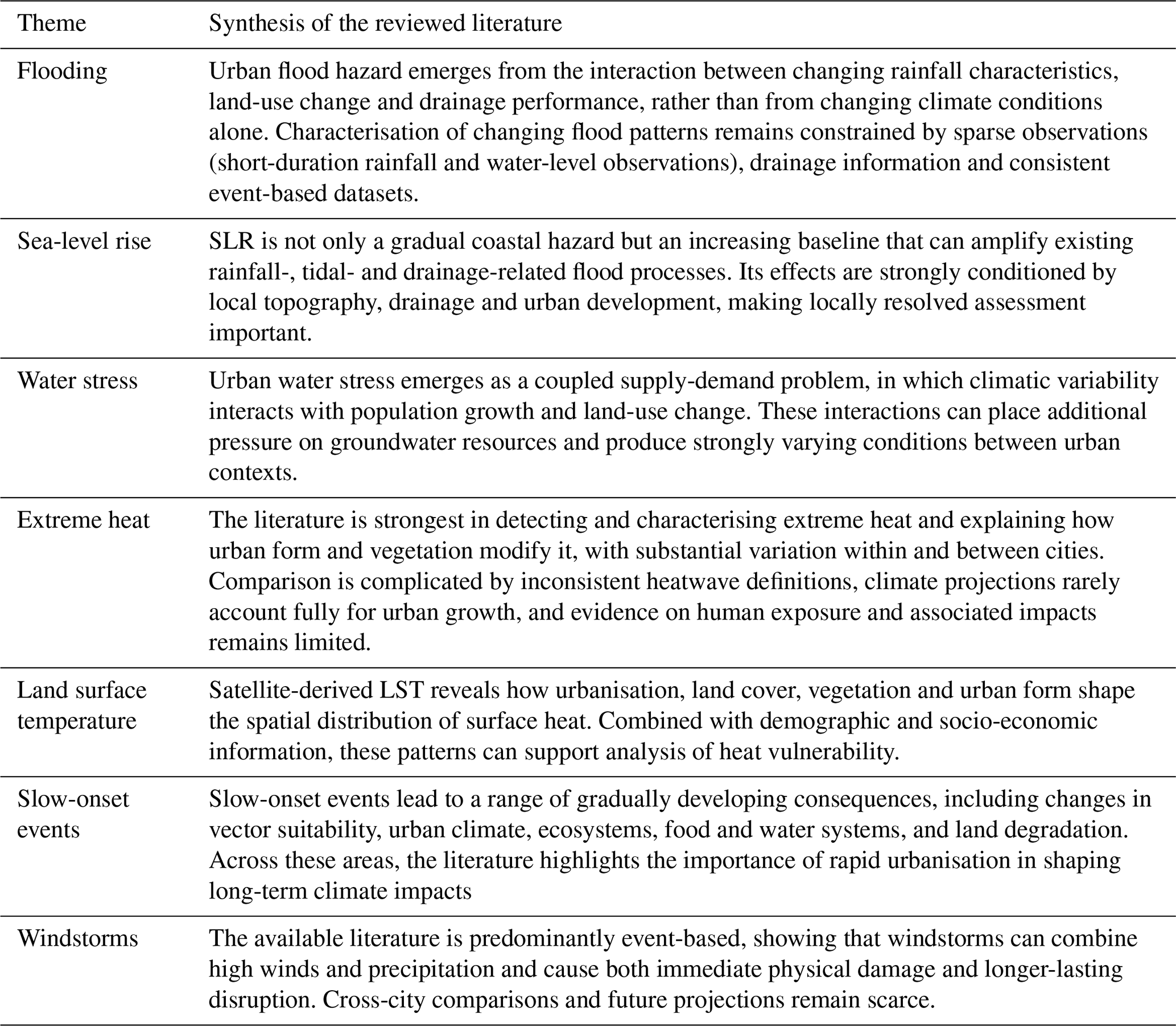
Table 2Synoptic synthesis of the main findings from the reviewed literature across climate hazard themes.
Long-term changes in rainfall provide another pathway through which gradual climatic shifts affect urban systems. While extreme precipitation directly affects populations (Azagoun et al., 2025), changing rainfall patterns also place pressure on agriculture and urban food security (Atiem et al., 2022; Bassirou and Bitondo, 2023), and on present-day water-resource management (Abraha et al., 2022), with these pressures expected to increase in the future (Gamal et al., 2024; Klutse et al., 2024). Although rainfall trends vary considerably by region and season, changing rainfall patterns can contribute to increasingly irregular water availability and declining urban water quality (Gule et al., 2024; Senbore and Oke, 2023). The reviewed evidence thus links changing rainfall not only to extreme events, but also to longer-term pressures on food and water systems.
Land degradation represents a related downstream impact of rainfall variability and extreme precipitation, compounded by urbanisation. Uncontrolled urban expansion and human pressure can hinder effective land management and conservation, contributing to increased soil erosion (Marondedze and Schütt, 2021; Salhi et al., 2023). Beyond the deterioration of soil quality, these processes can contribute to soil instability and landslides (Dille et al., 2022; Obda et al., 2022) as well as coastal erosion (Marzouk et al., 2021). This illustrates how gradual climatic and urban pressures can accumulate into physical changes in land systems and, ultimately, additional hazards.
Across these different pathways, a common consequence is the accumulation of long-term socioeconomic impacts. Infrastructure (Lane-Visser and Vanderschuren, 2024), economic assets (De Wit et al., 2023) and human capital (Iradukunda et al., 2023) are all projected to face increasing risks. The literature therefore portrays slow-onset events less as a single hazard than as a set of interacting and cumulative pressures transmitted through urban health, ecosystems, water and food systems, land and socioeconomic assets.
4.2.7 Wind storms
Windstorms are a climate-related hazard affecting both coastal and inland areas and cities across Africa. In southeastern Africa, tropical cyclones can combine high wind speeds with heavy precipitation (Williamson et al., 2023). High winds can severely damage buildings and essential infrastructure, with particularly severe impacts in vulnerable urban areas (Kafi et al., 2021). Beyond direct physical damage, wind-driven disasters can cause longer-lasting disruptions to basic services and household access to essential resources, thereby compounding existing vulnerability and inequality (Williamson et al., 2023). The available evidence therefore shows that windstorm impacts extend beyond immediate physical damage to include wider and potentially longer-lasting disruption of urban services and livelihoods.
However, the evidence base remains limited. The studies reviewed here focus mainly on individual events and observed impacts, while comparisons across cities, future projections, and analyses linking wind hazards with urban exposure and building vulnerability remain scarce.
4.3 Synthesis of thematic reviews
Building on the thematic assessment in Sect. 4.2, Table 2 provides a synoptic overview of the main findings emerging from the reviewed literature across the different hazard themes. The table complements the more detailed discussion above by highlighting the principal synthesis for each theme.
This assessment selected and examined 272 peer-reviewed articles (2015–2025) addressing climate hazard in African cities, combining quantitative mapping and hazard-based expert review. Together, these approaches reveal a rapidly expanding but methodologically constrained knowledge base.
The main findings are as follows:
-
A fundamental limitation concerns the availability of high-resolution data. Many studies rely on coarse climate projections or sparse in-situ monitoring networks that are not tailored for urban-scale processes. Sub-hourly rainfall records, dense temperature observations and modelling, and fine-scale socio-economic datasets remain scarce across much of the continent. High-resolution urban climate modelling with explicit representation of urban morphology and materials is also relatively rare. As a result, urban heat islands, pluvial flooding, compound coastal risks and exposure patterns are often assessed at spatial and temporal resolutions insufficient to capture intra-urban variability. This limits the ability to move towards actionable and contextually specific adaptation planning.
-
Earth Observation (EO) has become a central methodological pillar of the field, particularly through the use of Landsat imagery for land surface temperature and urban growth analysis. In data-scarce regions, EO provides a consistent and scalable source of information that partly compensates for limited ground-based monitoring. However, its application remains concentrated on surface temperature diagnostics and historical land-cover change. The relative share of EO-based studies has remained stable over the past decade. This suggests that, despite significant advances in sensor resolution, data availability and processing capacity, its broader potential remains underexploited.
-
The geographic distribution of research is highly imbalanced. A small number of countries accounts for a disproportionate share of publications. Central Africa in particular remains a blind spot. Capital cities dominate the literature, and fast-growing secondary cities are underrepresented. This skewed view carries a risk of reinforcing existing disparities in climate knowledge and planning capacity.
-
Thematic coverage remains uneven. Flooding and heat-related topics dominate the literature, whereas hazards such as sea-level rise, windstorms and urban water stress receive comparatively limited attention. Additional cross-hazard screening shows that substantive consideration of more than one hazard occurs, but remains limited and uneven across hazard categories. Explicit analysis of interactions between hazards is considerably rarer.
-
Social dimensions are insufficiently embedded in quantitative assessments. Informal settlements, poverty, governance capacity and inequality are frequently acknowledged but rarely integrated systematically into modelling or risk frameworks. Health impacts – particularly those directly linked to extreme heat and long-term socio-economic consequences – remain underdeveloped relative to projected climate trends.
-
The literature is predominantly retrospective. Most studies assess historical climate variability or past urban growth. Only a limited number integrate future climate scenarios with projected urban expansion or demographic change. As a consequence, while present-day patterns are increasingly well documented, robust assessments of long-term urban transformation under climate change remain scarce.
These findings point to several priorities for future research. First, the strong representation of large cities means that current knowledge is disproportionately shaped by metropolitan contexts. Where local evidence is lacking, smaller and secondary cities may therefore have to rely on hazard information derived from substantially different urban settings, which may not adequately reflect their local conditions and adaptation needs. Greater research attention to small and secondary cities is consequently needed.
Second, the uneven representation of climate zones affects the range of hazard conditions captured by the available evidence. For example, strong representation of dry climates in heat-related research may favour an understanding of heat dominated by high-temperature and dry-heat conditions, whereas humidity becomes an important component of human heat stress in more humid climates. Research in currently underrepresented climate zones is therefore needed to broaden the climatic conditions represented in the evidence base.
Third, the predominance of flooding and heat in the literature should not be interpreted as evidence of their relative importance across African cities. Rather, the observed distribution reflects research attention within the reviewed literature. Greater attention to currently understudied hazards is needed, particularly where their relevance may increase under climate change. Research should also move beyond the predominantly single-hazard perspective by more explicitly considering interactions between hazards where relevant.
Finally, the strong bias towards historical and present-day conditions is particularly important given the major urban expansion anticipated across Africa. Future cities may differ substantially from present-day cities in spatial extent, land cover and population distribution. Hazard assessments that account for future climate change while disregarding future urban growth may therefore provide an incomplete basis for long-term adaptation decisions. Greater emphasis is needed on studies that jointly consider future climate and urban development.
Across these priorities, improved high-resolution observations and urban-scale modelling remain important, while Earth Observation offers a particularly valuable source of consistent and scalable information in data-scarce regions. However, EO is still used mainly for analysing land surface temperature and historical land-cover change, while its potential for other applications remains underexploited. Together, broader geographic and climatic representation, greater attention to secondary cities and understudied hazards, and stronger integration of future climate and urban development would provide a more representative evidence base for adaptation and resilience planning in African cities.
The list of 272 scientific articles used as a basis for the review has been provided under Supplement Material S1.
KDR: conceptualization, data curation, formal analysis, visualization, funding acquisition, methodology, writing – original draft. MA, HB, TC, BL, JL, AN, MS, NS, and IU: investigation, writing – original draft. OS: supervision, writing – review and editing, funding acquisition. NV: writing – review and editing, project administration.
The contact author has declared that none of the authors has any competing interests.
Publisher's note: Copernicus Publications remains neutral with regard to jurisdictional claims made in the text, published maps, institutional affiliations, or any other geographical representation in this paper. The authors bear the ultimate responsibility for providing appropriate place names. Views expressed in the text are those of the authors and do not necessarily reflect the views of the publisher.
The research presented here was conducted within the project “Climate analysis in African cities (CAIAC)”, which is funded by the European Space Agency (ESA) under its “Climate Change & Cities” programme. The authors thank ESA's Clement Albergel and Amy Campbell for valuable discussions and constructive comments on the manuscript.
This research has been supported by the European Space Agency (contract no. 4000148449/25/I/LR).
This paper was edited by Olga Petrucci and reviewed by Milad Basirifard and Manoel Cardoso.
Abdrabo, M. A., Abdelwahab, R. G., and Hassaan, M. A.: Urban dynamics and potential vulnerability of coastal urban areas to sea level rise in the southeastern Levantine Basin, Urban Clim., 44, 101212, https://doi.org/10.1016/j.uclim.2022.101212, 2022.
Abraha, T., Tibebu, A., and Ephrem, G.: Rapid Urbanization and the Growing Water Risk Challenges in Ethiopia: The Need for Water Sensitive Thinking, Front. Water, 4, 890229, https://doi.org/10.3389/frwa.2022.890229, 2022.
Aliaga-Samanez, A., Romero, D., Murray, K., Segura, M., Real, R., and Olivero, J.: Potential climate change effects on the distribution of urban and sylvatic dengue and yellow fever vectors, Pathog. Glob. Health, 118, 397–407, https://doi.org/10.1080/20477724.2024.2369377, 2024.
Analy, M. and Laftouhi, N.-E.: Groundwater Depletion in an Urban Environment under Semiarid Climate and Persistent Drought–City of Marrakesh (Morocco), Water, 13, 3253, https://doi.org/10.3390/w13223253, 2021.
Anande, D. M. and Park, M.-S.: Impacts of Projected Urban Expansion on Rainfall and Temperature during Rainy Season in the Middle-Eastern Region in Tanzania, Atmosphere, 12, 1234, https://doi.org/10.3390/atmos12101234, 2021.
Andreasen, M. H., Agergaard, J., Allotey, A. N. M., Møller-Jensen, L., and Oteng-Ababio, M.: Built-in Flood Risk: the Intertwinement of Flood Risk and Unregulated Urban Expansion in African Cities, Urban Forum, 34, 385–411, https://doi.org/10.1007/s12132-022-09478-4, 2023.
Ansah, E. W., Amoadu, M., Obeng, P., and Sarfo, J. O.: Climate change, urban vulnerabilities and adaptation in Africa: a scoping review, Clim. Change, 177, 71, https://doi.org/10.1007/s10584-024-03711-8, 2024.
Arsiso, B. K., Mengistu Tsidu, G., and Stoffberg, G. H.: Signature of present and projected climate change at an urban scale: The case of Addis Ababa, Phys. Chem. Earth Parts ABC, 105, 104–114, https://doi.org/10.1016/j.pce.2018.03.008, 2018.
Athukorala, D. and Murayama, Y.: Spatial Variation of Land Use/Cover Composition and Impact on Surface Urban Heat Island in a Tropical Sub-Saharan City of Accra, Ghana, Sustainability, 12, 7953, https://doi.org/10.3390/su12197953, 2020.
Atiem, I. A., Siddig, M. S. A., Hamukwaya, S. L., Ahmed, H. I., Taha, M. M. M., Ibrahim, S., and Osman, Y.: Assessment of Seasonal Rainfall Drought Indices, Nyala City Sudan, Agriculture, 12, 1069, https://doi.org/10.3390/agriculture12071069, 2022.
Ayanlade, A.: Safe drinking water supply under extreme climate events: evidence from four urban sprawl communities, Clim. Dev., 16, 563–578, https://doi.org/10.1080/17565529.2023.2264270, 2024.
Ayompe, L. M., Davis, S. J., and Egoh, B. N.: Trends and drivers of African fossil fuel CO2 emissions 1990–2017, Environ. Res. Lett., 15, 124039, https://doi.org/10.1088/1748-9326/abc64f, 2020.
Azagoun, V. V. A., Komi, K., Vissin, E. W., and Klassou, K. S.: Analysis of the Dynamics of Hydroclimatic Extremes in Urban Areas: The Case of Grand-Nokoué in Benin, West Africa, Climate, 13, 39, https://doi.org/10.3390/cli13020039, 2025.
Bassirou, Y. and Bitondo, D.: Analysis of rainfall dynamics in the three main cities of northern Cameroon, Environ. Monit. Assess., 195, 640, https://doi.org/10.1007/s10661-023-11208-7, 2023.
Beck, H. E., McVicar, T. R., Vergopolan, N., Berg, A., Lutsko, N. J., Dufour, A., Zeng, Z., Jiang, X., Van Dijk, A. I. J. M., and Miralles, D. G.: High-resolution (1 km) Köppen-Geiger maps for 1901–2099 based on constrained CMIP6 projections, Sci. Data, 10, 724, https://doi.org/10.1038/s41597-023-02549-6, 2023.
Beshir, A. A. and Song, J.: Urbanization and its impact on flood hazard: the case of Addis Ababa, Ethiopia, Nat. Hazards, 109, 1167–1190, https://doi.org/10.1007/s11069-021-04873-9, 2021.
Boko, B. A., Konaté, M., Yalo, N., Berg, S. J., Erler, A. R., Bazié, P., Hwang, H.-T., Seidou, O., Niandou, A. S., Schimmel, K., and Sudicky, E. A.: High-Resolution, Integrated Hydrological Modeling of Climate Change Impacts on a Semi-Arid Urban Watershed in Niamey, Niger, Water, 12, 364, https://doi.org/10.3390/w12020364, 2020.
Brousse, O., Georganos, S., Demuzere, M., Dujardin, S., Lennert, M., Linard, C., Snow, R. W., Thiery, W., and Van Lipzig, N. P. M.: Can we use local climate zones for predicting malaria prevalence across sub-Saharan African cities?, Environ. Res. Lett., 15, 124051, https://doi.org/10.1088/1748-9326/abc996, 2020a.
Brousse, O., Wouters, H., Demuzere, M., Thiery, W., Van De Walle, J., and Van Lipzig, N. P. M.: The local climate impact of an African city during clear-sky conditions – Implications of the recent urbanization in Kampala (Uganda), Int. J. Climatol., 40, 4586–4608, https://doi.org/10.1002/joc.6477, 2020b.
Buchhorn, M., Lesiv, M., Tsendbazar, N.-E., Herold, M., Bertels, L., and Smets, B.: Copernicus Global Land Cover Layers – Collection 2, Remote Sens., 12, 1044, https://doi.org/10.3390/rs12061044, 2020.
Bulti, D. T., Abebe, B. G., and Biru, Z.: Analysis of the changes in historical and future extreme precipitation under climate change in Adama city, Ethiopia, Model. Earth Syst. Environ., 7, 2575–2587, https://doi.org/10.1007/s40808-020-01019-x, 2021.
Calvin, K., Dasgupta, D., Krinner, G., Mukherji, A., Thorne, P. W., Trisos, C., Romero, J., Aldunce, P., Barrett, K., Blanco, G., Cheung, W. W. L., Connors, S., Denton, F., Diongue-Niang, A., Dodman, D., Garschagen, M., Geden, O., Hayward, B., Jones, C., Jotzo, F., Krug, T., Lasco, R., Lee, Y.-Y., Masson-Delmotte, V., Meinshausen, M., Mintenbeck, K., Mokssit, A., Otto, F. E. L., Pathak, M., Pirani, A., Poloczanska, E., Pörtner, H.-O., Revi, A., Roberts, D. C., Roy, J., Ruane, A. C., Skea, J., Shukla, P. R., Slade, R., Slangen, A., Sokona, Y., Sörensson, A. A., Tignor, M., Van Vuuren, D., Wei, Y.-M., Winkler, H., Zhai, P., Zommers, Z., Hourcade, J.-C., Johnson, F. X., Pachauri, S., Simpson, N. P., Singh, C., Thomas, A., Totin, E., Alegría, A., Armour, K., Bednar-Friedl, B., Blok, K., Cissé, G., Dentener, F., Eriksen, S., Fischer, E., Garner, G., Guivarch, C., Haasnoot, M., Hansen, G., Hauser, M., Hawkins, E., Hermans, T., Kopp, R., Leprince-Ringuet, N., Lewis, J., Ley, D., Ludden, C., Niamir, L., Nicholls, Z., Some, S., Szopa, S., Trewin, B., Van Der Wijst, K.-I., Winter, G., Witting, M., Birt, A., and Ha, M.: IPCC, 2023: Climate Change 2023: Synthesis Report. Contribution of Working Groups I, II and III to the Sixth Assessment Report of the Intergovernmental Panel on Climate Change, edited by: Core Writing Team, Lee, H., and Romero, J., IPCC, Geneva, Switzerland, Intergovernmental Panel on Climate Change (IPCC), https://doi.org/10.59327/IPCC/AR6-9789291691647, 2023.
Carr, E. R., Goble, R., Rosko, H. M., Vaughan, C., and Hansen, J.: Identifying climate information services users and their needs in Sub-Saharan Africa: a review and learning agenda, Clim. Dev., 12, 23–41, https://doi.org/10.1080/17565529.2019.1596061, 2020.
Cheng, X., Peng, J., Dong, J., Liu, Y., and Wang, Y.: Non-linear effects of meteorological variables on cooling efficiency of African urban trees, Environ. Int., 169, 107489, https://doi.org/10.1016/j.envint.2022.107489, 2022.
Codjoe, S. N. A., Gough, K. V., Wilby, R. L., Kasei, R., Yankson, P. W. K., Amankwaa, E. F., Abarike, M. A., Atiglo, D. Y., Kayaga, S., Mensah, P., Nabilse, C. K., and Griffiths, P. L.: Impact of extreme weather conditions on healthcare provision in urban Ghana, Soc. Sci. Med., 258, 113072, https://doi.org/10.1016/j.socscimed.2020.113072, 2020.
Corburn, J., Njoroge, P., Weru, J., and Musya, M.: Urban Climate Justice, Human Health, and Citizen Science in Nairobi's Informal Settlements, Urban Sci., 6, 36, https://doi.org/10.3390/urbansci6020036, 2022.
Damte, E., Manteaw, B. O., and Wrigley-Asante, C.: Urbanization, climate change and health vulnerabilities in slum communities in Ghana, J. Clim. Change Health, 10, 100189, https://doi.org/10.1016/j.joclim.2022.100189, 2023.
De Wit, M., Rawlins, J., and Petrie, B.: Economic risk assessment of climate change at the city level. The case of Cape Town, South Africa, Int. J. Urban Sustain. Dev., 15, 118–140, https://doi.org/10.1080/19463138.2023.2193813, 2023.
Deton, Y., Kamou, H., Atato, A., Kombate, B., Mabafei, A., Yoka, J., Dourma, M., Guelly, A. K., Batawila, K., and Akpagana, K.: Spatiotemporal Dynamics of Urban Green Spaces and Climatic Vulnerability of Togolese Cities in the Context of Rapid Urbanisation: The Case of Lome and Kara, Land, 14, 471, https://doi.org/10.3390/land14030471, 2025.
Dille, A., Dewitte, O., Handwerger, A. L., d'Oreye, N., Derauw, D., Ganza Bamulezi, G., Ilombe Mawe, G., Michellier, C., Moeyersons, J., Monsieurs, E., Mugaruka Bibentyo, T., Samsonov, S., Smets, B., Kervyn, M., and Kervyn, F.: Acceleration of a large deep-seated tropical landslide due to urbanization feedbacks, Nat. Geosci., 15, 1048–1055, https://doi.org/10.1038/s41561-022-01073-3, 2022.
Dos Santos, S., Adams, E. A., Neville, G., Wada, Y., De Sherbinin, A., Mullin Bernhardt, E., and Adamo, S. B.: Urban growth and water access in sub-Saharan Africa: Progress, challenges, and emerging research directions, Sci. Total Environ., 607–608, 497–508, https://doi.org/10.1016/j.scitotenv.2017.06.157, 2017.
Douglas, I.: Flooding in African cities, scales of causes, teleconnections, risks, vulnerability and impacts, Int. J. Disast. Risk Re., 26, 34–42, https://doi.org/10.1016/j.ijdrr.2017.09.024, 2017.
Dufitimana, E., Gahungu, P., Uwayezu, E., Mugisha, E., and Bizimana, J. P.: Integrating Machine Learning and Geospatial Data for Mapping Socioeconomic Vulnerability to Urban Natural Hazard, ISPRS Int. J. Geo-Inf., 14, 161, https://doi.org/10.3390/ijgi14040161, 2025.
Dumedah, G., Andam-Akorful, S. A., Ampofo, S. T., and Abugri, I.: Characterizing urban morphology types for surface runoff estimation in the Oforikrom Municipality of Ghana, J. Hydrol. Reg. Stud., 34, 100796, https://doi.org/10.1016/j.ejrh.2021.100796, 2021.
Egondi, T., Kyobutungi, C., and Rocklöv, J.: Temperature Variation and Heat Wave and Cold Spell Impacts on Years of Life Lost Among the Urban Poor Population of Nairobi, Kenya, Int. J. Environ. Res. Pub. He., 12, 2735–2748, https://doi.org/10.3390/ijerph120302735, 2015.
Ekwueme, B. N.: Machine Learning Based Prediction of Urban Flood Susceptibility from Selected Rivers in a Tropical Catchment Area, Civ. Eng. J., 8, 1857–1878, https://doi.org/10.28991/CEJ-2022-08-09-08, 2022.
Fekete, A. and Subramanian, S.: Multi-risks attributed to climate change and urbanization in East Africa: a bibliometric analysis of a science gap, Afr. Geogr. Rev., 43, 735–757, https://doi.org/10.1080/19376812.2023.2256696, 2024.
Foster, S. and Gathu, J.: Groundwater use for urban water security in tropical Africa – operational situation and institutional perspectives, Water Int., 49, 782–791, https://doi.org/10.1080/02508060.2024.2358470, 2024.
Frimpong, B. F., Koranteng, A., and Molkenthin, F.: Analysis of temperature variability utilising Mann–Kendall and Sen's slope estimator tests in the Accra and Kumasi Metropolises in Ghana, Environ. Syst. Res., 11, 24, https://doi.org/10.1186/s40068-022-00269-1, 2022.
Gamal, G., Nejedlik, P., and El Kenawy, A. M.: Assessing Future Precipitation Patterns, Extremes and Variability in Major Nile Basin Cities: An Ensemble Approach with CORDEX CORE Regional Climate Models, Climate, 12, https://doi.org/10.3390/cli12010009, 2024.
Ghribi, M. and Dahech, S.: The Impact of the Urban Heat Island on the Sensation of Thermal Comfort and Electricity Consumption in Sfax in Central-Eastern Tunisia during the Hot Season, Energies, 16, 911, https://doi.org/10.3390/en16020911, 2023.
Graça, M., Cruz, S., Monteiro, A., and Neset, T.-S.: Designing urban green spaces for climate adaptation: A critical review of research outputs, Urban Clim., 42, 101126, https://doi.org/10.1016/j.uclim.2022.101126, 2022.
Gule, T. T., Hailu, B. T., and Lemma, B.: The Ripple Effect of Climate Change: Assessing the Impacts on Water Quality and Hydrology in Addis Ababa City (Akaki Catchment), Scientifica, 2024, 1–15, https://doi.org/10.1155/2024/8824622, 2024.
Gumbo, A. D. and Kapangaziwiri, E.: The fate of the City of Mutare's urban water supply as changing climate impacts on its source in the Pungwe sub-catchment, River Res. Appl., 39, 1846–1856, https://doi.org/10.1002/rra.3883, 2023.
Gyimah, R. R.: The hot zones are cities: Methodological outcomes and synthesis of surface urban heat island effect in Africa, Cogent Soc. Sci., 9, 2165651, https://doi.org/10.1080/23311886.2023.2165651, 2023.
Halecki, W. and Bedla, D.: Flood Exposure Patterns Induced by Sea Level Rise in Coastal Urban Areas of Europe and North Africa, Water, 17, 1889, https://doi.org/10.3390/w17131889, 2025.
Hamdi, R., Kusaka, H., Doan, Q.-V., Cai, P., He, H., Luo, G., Kuang, W., Caluwaerts, S., Duchêne, F., Van Schaeybroek, B., and Termonia, P.: The State-of-the-Art of Urban Climate Change Modeling and Observations, Earth Syst. Environ., 4, 631–646, https://doi.org/10.1007/s41748-020-00193-3, 2020.
Hassan, B. T., Yassine, M., and Amin, D.: Comparison of Urbanization, Climate Change, and Drainage Design Impacts on Urban Flashfloods in an Arid Region: Case Study, New Cairo, Egypt, Water, 14, 2430, https://doi.org/10.3390/w14152430, 2022.
Hlahla, S. and Hill, T. R.: Responses to Climate Variability in Urban Poor Communities in Pietermaritzburg, KwaZulu-Natal, South Africa, Sage Open, 8, 2158244018800914, https://doi.org/10.1177/2158244018800914, 2018.
Hoornweg, D. and Pope, K.: Population predictions for the world's largest cities in the 21st century, Environ. Urban., 29, 195–216, https://doi.org/10.1177/0956247816663557, 2017.
Hunter, N., North, M., Roberts, D., and Slotow, R.: A systematic map of responses to climate impacts in urban Africa, Environ. Res. Lett., 15, 103005, https://doi.org/10.1088/1748-9326/ab9d00, 2020.
Igun, E., Xu, X., Shi, Z., and Jia, G.: Enhanced nighttime heatwaves over African urban clusters, Environ. Res. Lett., 18, 014001, https://doi.org/10.1088/1748-9326/aca920, 2023.
IPCC: Climate Change 2022 – Impacts, Adaptation and Vulnerability: Working Group II Contribution to the Sixth Assessment Report of the Intergovernmental Panel on Climate Change, 1st ed., Cambridge University Press, https://doi.org/10.1017/9781009325844, 2023.
Iradukunda, P., Mwanaumo, E. M., and Kabika, J.: Hydroclimatic trend analysis and projection in Africa tropical urban regions: Cases of Lusaka, Zambia and Kigali, Rwanda, Urban Clim., 52, 101680, https://doi.org/10.1016/j.uclim.2023.101680, 2023.
Kabano, P., Harris, A., and Lindley, S.: Spatiotemporal dynamics of urban climate during the wet-dry season transition in a tropical African city, Int. J. Biometeorol., 66, 385–396, https://doi.org/10.1007/s00484-020-02061-1, 2022.
Kafi, K. M., Barau, A. S., and Aliyu, A.: The effects of windstorm in African medium-sized cities: An analysis of the degree of damage using KDE hotspots and EF-scale matrix, Int. J. Disast. Risk Re., 55, 102070, https://doi.org/10.1016/j.ijdrr.2021.102070, 2021.
Kamal, S. A., Darwish, N., Alhogoraty, E., Kaiser, M., Abdelbasset, K., and Gaber, A.: Mapping the expected combined impact of climate change and land subsidence on selected cities along the Nile Delta using radar images, Model. Earth Syst. Environ., 11, 241, https://doi.org/10.1007/s40808-025-02410-2, 2025.
Kamkuemah, M., Ayo-Yusuf, O., and Oni, T.: Future proofing health in response to climate change and rapid urbanisation in Africa, BMJ, e076476, https://doi.org/10.1136/bmj-2023-076476, 2024.
Kayaga, S. M., Amankwaa, E. F., Gough, K. V., Wilby, R. L., Abarike, M. A., Codjoe, S. N. A., Kasei, R., Nabilse, C. K., Yankson, P. W. K., Mensah, P., Abdullah, K., and Griffiths, P.: Cities and extreme weather events: impacts of flooding and extreme heat on water and electricity services in Ghana, Environ. Urban., 33, 131–150, https://doi.org/10.1177/0956247820952030, 2021.
Keramitsoglou, I., Daglis, I. A., Amiridis, V., Chrysoulakis, N., Ceriola, G., Manunta, P., Maiheu, B., De Ridder, K., Lauwaet, D., and Paganini, M. F.: Evaluation of satellite-derived products for the characterization of the urban thermal environment, J. Appl. Remote Sens., 6, 1–15, https://doi.org/10.1117/1.JRS.6.061704, 2012.
Kita, S. M.: Urban vulnerability, disaster risk reduction and resettlement in Mzuzu city, Malawi, Int. J. Disast. Risk Re., 22, 158–166, https://doi.org/10.1016/j.ijdrr.2017.03.010, 2017.
Klutse, N. A. B., Abiodun, B. J., Quagraine, K. A., Nkrumah, F., Abaton, A. A., Adekoke, J., Sylla, M. B., Berkoh-Oforiwaa, R., Koffi, H. A., and Essien, P.: Projected Changes in Rainfall Extremes over West African Cities Under Specific Global Warming Levels Using CORDEX and NEX-GDDP Datasets, Earth Syst. Environ., 8, 747–764, https://doi.org/10.1007/s41748-024-00425-w, 2024.
Koko, A. F., Yue, W., Abubakar, G. A., Alabsi, A. A. N., and Hamed, R.: Spatiotemporal Influence of Land Use/Land Cover Change Dynamics on Surface Urban Heat Island: A Case Study of Abuja Metropolis, Nigeria, ISPRS Int. J. Geo-Inf., 10, 272, https://doi.org/10.3390/ijgi10050272, 2021.
Lameche, E. K., Boutaghane, H., Saber, M., Abdrabo, K. I., Bermad, A. M., Djeddou, M., Boulmaiz, T., Kantoush, S. A., and Sumi, T.: Urban flood numerical modeling and hydraulic performance of a drainage network: A case study in Algiers, Algeria, Water Sci. Technol., 88, 1635–1656, https://doi.org/10.2166/wst.2023.277, 2023.
Lane-Visser, T. E. and Vanderschuren, M. J. W. A.: A climate-impact-related transport infrastructure risk assessment for the City of Cape Town, J. South Afr. Inst. Civ. Eng., 65, 52–64, https://doi.org/10.17159/2309-8775/2023/v65n4a5, 2024.
Leal Filho, W., Tuladhar, L., Li, C., Balogun, A.-L. B., Kovaleva, M., Abubakar, I. R., Azadi, H., and Donkor, F. K. K.: Climate change and extremes: implications on city livability and associated health risks across the globe, Int. J. Clim. Change Str., 15, 1–19, https://doi.org/10.1108/IJCCSM-07-2021-0078, 2023.
Li, M., Wang, Y., Rosier, J. F., Verburg, P. H., and Van Vliet, J.: Global maps of 3D built-up patterns for urban morphological analysis, Int. J. Appl. Earth Obs., 114, 103048, https://doi.org/10.1016/j.jag.2022.103048, 2022a.
Li, X., Stringer, L. C., and Dallimer, M.: The Impacts of Urbanisation and Climate Change on the Urban Thermal Environment in Africa, Climate, 10, 164, https://doi.org/10.3390/cli10110164, 2022b.
Li, X., Stringer, L. C., and Dallimer, M.: The role of blue green infrastructure in the urban thermal environment across seasons and local climate zones in East Africa, Sustain. Cities Soc., 80, 103798, https://doi.org/10.1016/j.scs.2022.103798, 2022c.
Marondedze, A. K. and Schütt, B.: Predicting the Impact of Future Land Use and Climate Change on Potential Soil Erosion Risk in an Urban District of the Harare Metropolitan Province, Zimbabwe, Remote Sens., 13, 4360, https://doi.org/10.3390/rs13214360, 2021.
Marzouk, M., Attia, K., and Azab, S.: Assessment of Coastal Vulnerability to Climate Change Impacts using GIS and Remote Sensing: A Case Study of Al-Alamein New City, J. Clean. Prod., 290, 125723, https://doi.org/10.1016/j.jclepro.2020.125723, 2021.
Matos, J. P., Ferreira, F., Mendes, D., and Matos, J. S.: Evaluating Compound Flooding Risks in Coastal Cities under Climate Change—The Maputo Case Study, in Mozambique, Sustainability, 15, 14497, https://doi.org/10.3390/su151914497, 2023.
Melchiorri, M.: The global human settlement layer sets a new standard for global urban data reporting with the urban centre database, Front. Environ. Sci., 10, 1003862, https://doi.org/10.3389/fenvs.2022.1003862, 2022.
Melese, M., Anteneh, M., and Bantigegn, S.: Urbanization and land surface temperature dynamics in Bahir Dar, Ethiopia: a comparative analysis of pre- and post-capital status, Front. Environ. Sci., 13, 1569636, https://doi.org/10.3389/fenvs.2025.1569636, 2025.
Mhedhbi, Z., Mazzega, P., Gaston, M., Haouès-Jouve, S., and Hidalgo, J.: Mining the Web of Science for African cities and climate change (1991–2021), Front. Sustain. Cities, 5, 989266, https://doi.org/10.3389/frsc.2023.989266, 2023.
Miller, J., Taylor, C., Guichard, F., Peyrillé, P., Vischel, T., Fowe, T., Panthou, G., Visman, E., Bologo, M., Traore, K., Coulibaly, G., Chapelon, N., Beucher, F., Rowell, D. P., and Parker, D. J.: High-impact weather and urban flooding in the West African Sahel – A multidisciplinary case study of the 2009 event in Ouagadougou, Weather Clim. Extrem., 36, 100462, https://doi.org/10.1016/j.wace.2022.100462, 2022.
Montfort, S., Callaghan, M., Creutzig, F., Lamb, W. F., Lu, C., Repke, T., Ge, K., and Minx, J.: Systematic global stocktake of over 50,000 urban climate change studies, Nat. Cities, 2, 613–625, https://doi.org/10.1038/s44284-025-00260-8, 2025.
Montgomery, M. J., Harwood, J. F., Yougang, A. P., Wilson-Bahun, T. A., Tedjou, A. N., Keumeni, C. R., Wondji, C. S., Kamgang, B., and Kilpatrick, A. M.: The effects of urbanization, temperature, and rainfall on Aedes aegypti and Aedes albopictus mosquito abundance across a broad latitudinal gradient in Central Africa, Parasit. Vectors, 18, 135, https://doi.org/10.1186/s13071-025-06764-5, 2025.
Morakinyo, T. E., Adegun, O. B., and Balogun, A. A.: The effect of vegetation on indoor and outdoor thermal comfort conditions: Evidence from a microscale study of two similar urban buildings in Akure, Nigeria, Indoor Built Environ., 25, 603–617, https://doi.org/10.1177/1420326X14562455, 2016.
Mukim, M. and Roberts, M. (Eds.): Thriving: Making Cities Green, Resilient, and Inclusive in a Changing Climate, The World Bank, https://doi.org/10.1596/978-1-4648-1935-3, 2023.
Mushore, T. D., Odindi, J., Dube, T., and Mutanga, O.: Prediction of future urban surface temperatures using medium resolution satellite data in Harare metropolitan city, Zimbabwe, Build. Environ., 122, 397–410, https://doi.org/10.1016/j.buildenv.2017.06.033, 2017.
Mushore, T. D., Dube, T., Manjowe, M., Gumindoga, W., Chemura, A., Rousta, I., Odindi, J., and Mutanga, O.: Remotely sensed retrieval of Local Climate Zones and their linkages to land surface temperature in Harare metropolitan city, Zimbabwe, Urban Clim., 27, 259–271, https://doi.org/10.1016/j.uclim.2018.12.006, 2019.
Neves, J. L., Sellick, T. K., Hasan, A., and Pilesjö, P.: Flood risk assessment under population growth and urban land use change in Matola, Mozambique, Afr. Geogr. Rev., 42, 539–559, https://doi.org/10.1080/19376812.2022.2076133, 2023.
Noby, M., See, L., Sharifi, A., and Hamdy, O.: Assessing urban growth exposure to sea level rise using a machine learning based model with Alexandria as a case study, Urban Clim., 58, 102217, https://doi.org/10.1016/j.uclim.2024.102217, 2024.
Obda, I., El Kharim, Y., Bounab, A., Lahrach, A., Ahniche, M., and Mansouri, H.: Multi-criteria assessment approach of slow-moving urban landslide hazard: the case of Moulay Yacoub, Morocco, Can. J. Earth Sci., 59, 300–317, https://doi.org/10.1139/cjes-2021-0064, 2022.
Obe, O. B., Morakinyo, T. E., and Mills, G.: An assessment of WRF-urban schemes in simulating local meteorology for heat stress analysis in a tropical sub-Saharan African city, Lagos, Nigeria, Int. J. Biometeorol., 68, 811–828, https://doi.org/10.1007/s00484-024-02627-3, 2024.
Odindi, J. O., Nongebeza, S., and Siro, N.: The influence of seasonal land-use-land-cover transformation on thermal characteristics within the city of Pietermaritzburg, South Afr. J. Geomat., 9, 348–364, https://doi.org/10.4314/sajg.v9i2.23, 2022.
Oiro, S., Comte, J.-C., Soulsby, C., MacDonald, A., and Mwakamba, C.: Depletion of groundwater resources under rapid urbanisation in Africa: recent and future trends in the Nairobi Aquifer System, Kenya, Hydrogeol. J., 28, 2635–2656, https://doi.org/10.1007/s10040-020-02236-5, 2020.
Osalla, J., Gouagna, L.-C., Rotich, G., Nzilani, M., Safari, P., Senagi, K., Mutuku, F., Torto, B., and Tchouassi, D. P.: Longitudinal surveillance of Aedes aegypti (Diptera: Culicidae) in urban coastal Kenya: population dynamics, blood feeding frequency and dengue virus infection rates, Sci. Rep., 15, 21787, https://doi.org/10.1038/s41598-025-05408-z, 2025.
Overland, I., Fossum Sagbakken, H., Isataeva, A., Kolodzinskaia, G., Simpson, N. P., Trisos, C., and Vakulchuk, R.: Funding flows for climate change research on Africa: where do they come from and where do they go?, Clim. Dev., 14, 705–724, https://doi.org/10.1080/17565529.2021.1976609, 2022.
Padji, C., Meukaleuni, C., Mezoue Adiang, C., Bongue, D., and Monkam, D.: Estimation of return dates and return levels of extreme rainfall in the city of Douala, Cameroon, Heliyon, 10, e34832, https://doi.org/10.1016/j.heliyon.2024.e34832, 2024.
Parker, C., Mahlasi, C., Govindasamy, T., Radebe, L., Brink, N. B., Jack, C., Doumbia, M., Kouakou, E., Chersich, M., Cissé, G., Makhanya, S., the HE2AT Center Group, Bobola, A., Tall, A., Ndikum, A., Aishatu, A., Vanga, A. F., Chikandiwa, A., Waljee, A., Beukes, A., Steynor, A., Joubert, B., Kone, B., Hewitson, B., Mwangi, C., Dumbura, C., Gao, C., Lakhoo, D., Thaldar, D. W., Mitchell, D., Donnelly, D.-L., Frederick, E., Vos, E., Baloyi, G. D., Marmelstein, G., Dely, I. D., Solarin, I., Maliha, I., Maguma, J., Tsvaki, J., Zhu, J., Sall, K., McAlpine, K., Quagraine, K., Mbano, L., Lois Harden, L., Abdulrauf, L., Brennan, M., McAllister, K., Langa, N., Emerence, O., Adegun, O., Ogendi, P., Marsh, P., Munyi, P., Kloppers, P., Wolski, P., Satekge, R., Duffett, R., Sibanda, R., Forget, R., Omar, S., Luchters, S., and Makanga, T.: Quantifying intra-urban socio-economic and environmental vulnerability to extreme heat events in Johannesburg, South Africa, Int. J. Biometeorol., https://doi.org/10.1007/s00484-025-02971-y, 2025.
Pereira Marghidan, C., Van Aalst, M., Blanford, J., Guigma, K., Pinto, I., Maure, G., and Marrufo, T.: Heatwaves in Mozambique 1983–2016: Characteristics, trends and city-level summaries using high-resolution CHIRTS-daily, Weather Clim. Extrem., 40, 100565, https://doi.org/10.1016/j.wace.2023.100565, 2023.
Rose, N. H., Sylla, M., Badolo, A., Lutomiah, J., Ayala, D., Aribodor, O. B., Ibe, N., Akorli, J., Otoo, S., Mutebi, J.-P., Kriete, A. L., Ewing, E. G., Sang, R., Gloria-Soria, A., Powell, J. R., Baker, R. E., White, B. J., Crawford, J. E., and McBride, C. S.: Climate and Urbanization Drive Mosquito Preference for Humans, Curr. Biol., 30, 3570-3579.e6, https://doi.org/10.1016/j.cub.2020.06.092, 2020.
Rother, H.-A.: Controlling and preventing climate-sensitive noncommunicable diseases in urban sub-Saharan Africa, Sci. Total Environ., 722, 137772, https://doi.org/10.1016/j.scitotenv.2020.137772, 2020.
Rusca, M., Savelli, E., Di Baldassarre, G., Biza, A., and Messori, G.: Unprecedented droughts are expected to exacerbate urban inequalities in Southern Africa, Nat. Clim. Change, 13, 98–105, https://doi.org/10.1038/s41558-022-01546-8, 2023.
Salhi, A., El Hasnaoui, Y., Pérez Cutillas, P., and Heggy, E.: Soil erosion and hydroclimatic hazards in major African port cities: the case study of Tangier, Sci. Rep., 13, 13158, https://doi.org/10.1038/s41598-023-40135-3, 2023.
Santos, M. M., Ferreira, A. V., and Lanzinha, J. C. G.: The Possibilities of Capturing Rainwater and Reducing the Impact of Floods: A Proposal for the City of Beira, Mozambique, Sustainability, 15, 2276, https://doi.org/10.3390/su15032276, 2023.
Senbore, S. and Oke, S. A.: Urban development impact on climate variability and surface water quality in part of Mangaung metropolis of South Africa, Dev. South. Afr., 40, 293–312, https://doi.org/10.1080/0376835X.2021.1993794, 2023.
Shiru, M. S., Shahid, S., Shiru, S., Chung, E. S., Alias, N., Ahmed, K., Dioha, E. C., Sa'adi, Z., Salman, S., Noor, M., Nashwan, M. S., Idlan, M. K., Khan, N., Momade, M. H., Houmsi, M. R., Iqbal, Z., Ishanch, Q., and Sediqi, M. N.: Challenges in water resources of Lagos mega city of Nigeria in the context of climate change, J. Water Clim. Change, 11, 1067–1083, https://doi.org/10.2166/wcc.2019.047, 2020.
Sinka, M. E., Pironon, S., Massey, N. C., Longbottom, J., Hemingway, J., Moyes, C. L., and Willis, K. J.: A new malaria vector in Africa: Predicting the expansion range of Anopheles stephensi and identifying the urban populations at risk, P. Natl. Acad. Sci., 117, 24900–24908, https://doi.org/10.1073/pnas.2003976117, 2020.
Snyder, H.: Literature review as a research methodology: An overview and guidelines, J. Bus. Res., 104, 333–339, https://doi.org/10.1016/j.jbusres.2019.07.039, 2019.
Souverijns, N., De Ridder, K., Veldeman, N., Lefebre, F., Kusambiza-Kiingi, F., Memela, W., and Jones, N. K. W.: Urban heat in Johannesburg and Ekurhuleni, South Africa: A meter-scale assessment and vulnerability analysis, Urban Clim., 46, 101331, https://doi.org/10.1016/j.uclim.2022.101331, 2022.
Souverijns, N., De Ridder, K., Takacs, S., Veldeman, N., Michielsen, M., Crols, T., Foamouhoue, A. K., Nshimirimana, G., Dan Dijé, I., and Tidjani, H.: High resolution heat stress over a Sahelian city: Present and future impact assessment and urban green effectiveness, Int. J. Climatol., 43, 7346–7364, https://doi.org/10.1002/joc.8268, 2023.
Tarawally, M., Xu, W., Hou, W., and Mushore, T.: Comparative Analysis of Responses of Land Surface Temperature to Long-Term Land Use/Cover Changes between a Coastal and Inland City: A Case of Freetown and Bo Town in Sierra Leone, Remote Sens., 10, 112, https://doi.org/10.3390/rs10010112, 2018.
Tedla, H. Z., Taye, E. F., Walker, D. W., and Haile, A. T.: Evaluation of WRF model rainfall forecast using citizen science in a data-scarce urban catchment: Addis Ababa, Ethiopia, J. Hydrol. Reg. Stud., 44, 101273, https://doi.org/10.1016/j.ejrh.2022.101273, 2022.
Traore, K. S., Obahoundje, S., Hauhouot, A. C., and Diedhiou, A.: Impacts of urbanization on land use change and its incidences on the climate: Case of Bingerville City (Ivory Coast, West Africa), AIMS Geosci., 11, 228–253, https://doi.org/10.3934/geosci.2025010, 2025.
UN-Habitat (Ed.): Envisaging the future of cities, UN-Habitat, Nairobi, Kenya, 387 pp., https://digitallibrary.un.org/record/3984713 (last access: 21 October 2026), 2022.
Van De Walle, J., Brousse, O., Arnalsteen, L., Brimicombe, C., Byarugaba, D., Demuzere, M., Jjemba, E., Lwasa, S., Misiani, H., Nsangi, G., Soetewey, F., Sseviiri, H., Thiery, W., Vanhaeren, R., Zaitchik, B. F., and Van Lipzig, N. P. M.: Lack of vegetation exacerbates exposure to dangerous heat in dense settlements in a tropical African city, Environ. Res. Lett., 17, 024004, https://doi.org/10.1088/1748-9326/ac47c3, 2022.
Van Eck, N. J. and Waltman, L.: Citation-based clustering of publications using CitNetExplorer and VOSviewer, Scientometrics, 111, 1053–1070, https://doi.org/10.1007/s11192-017-2300-7, 2017.
Weday, M. A., Tabor, K. W., and Gemeda, D. O.: Flood hazards and risk mapping using geospatial technologies in Jimma City, southwestern Ethiopia, Heliyon, 9, e14617, https://doi.org/10.1016/j.heliyon.2023.e14617, 2023.
Wemegah, C. S., Yamba, E. I., Quansah, E., Nyantakyi, E. K., and Amekudzi, L. K.: Evidence of Heatwaves: Characteristics and Trends in Selected Ghanaian Cities, Int. J. Climatol., e8889, https://doi.org/10.1002/joc.8889, 2025.
Wilby, R. L., Kasei, R., Gough, K. V., Amankwaa, E. F., Abarike, M., Anderson, N. J., Codjoe, S. N. A., Griffiths, P., Kaba, C., Abdullah, K., Kayaga, S., Matthews, T., Mensah, P., Murphy, C., and Yankson, P. W. K.: Monitoring and moderating extreme indoor temperatures in low-income urban communities, Environ. Res. Lett., 16, 024033, https://doi.org/10.1088/1748-9326/abdbf2, 2021.
Williamson, C., McCordic, C., and Doberstein, B.: The compounding impacts of Cyclone Idai and their implications for urban inequality, Int. J. Disast. Risk Re., 86, 103526, https://doi.org/10.1016/j.ijdrr.2023.103526, 2023.
Wulder, M. A., Loveland, T. R., Roy, D. P., Crawford, C. J., Masek, J. G., Woodcock, C. E., Allen, R. G., Anderson, M. C., Belward, A. S., Cohen, W. B., Dwyer, J., Erb, A., Gao, F., Griffiths, P., Helder, D., Hermosilla, T., Hipple, J. D., Hostert, P., Hughes, M. J., Huntington, J., Johnson, D. M., Kennedy, R., Kilic, A., Li, Z., Lymburner, L., McCorkel, J., Pahlevan, N., Scambos, T. A., Schaaf, C., Schott, J. R., Sheng, Y., Storey, J., Vermote, E., Vogelmann, J., White, J. C., Wynne, R. H., and Zhu, Z.: Current status of Landsat program, science, and applications, Remote Sens. Environ., 225, 127–147, https://doi.org/10.1016/j.rse.2019.02.015, 2019.
Yankson, P. W. K., Owusu, A. B., Owusu, G., Boakye-Danquah, J., and Tetteh, J. D.: Assessment of coastal communities' vulnerability to floods using indicator-based approach: a case study of Greater Accra Metropolitan Area, Ghana, Nat. Hazards, 89, 661–689, https://doi.org/10.1007/s11069-017-2985-1, 2017.
Zehra, D., Mbatha, S., Campos, L. C., Queface, A., Beleza, A., Cavoli, C., Achuthan, K., and Parikh, P.: Rapid flood risk assessment of informal urban settlements in Maputo, Mozambique: The case of Maxaquene A, Int. J. Disast. Risk Re., 40, 101270, https://doi.org/10.1016/j.ijdrr.2019.101270, 2019.
Zeleke, T. T., Giorgi, F., Diro, G. T., Zaitchik, B. F., Giuliani, G., Ayal, D., Kassahun, T., Sintayehu, W. D., and Demissie, T.: Effect of urbanization on East African climate as simulated by coupled urban-climate model, Clim. Serv., 31, 100398, https://doi.org/10.1016/j.cliser.2023.100398, 2023.
Zhao, M., Bounoua, L., Prime, N., Bahi, H., and Khan, Z.: The Interplay Between Climate and Urban Expansion on Building Energy Demand in Morocco, Urban Sci., 9, 168, https://doi.org/10.3390/urbansci9050168, 2025.