
the Creative Commons Attribution 4.0 License.
the Creative Commons Attribution 4.0 License.
 | 07 Sep 2026
Invited perspectives: reframing transboundary flood vulnerability through “Hydrosocial Connectivity” for just and adaptive governance

Rose Cook
Xilin Xia
Iseult Lynch
Transboundary flood risks are intensifying across South Asia due to climate change, land-use change, and rapid development in shared river basins. However, governance responses remain dominated by hydrological control and infrastructure-heavy strategies, overlooking the deeper social, institutional, and political drivers of vulnerability. We define transboundary flood vulnerability as the heightened and unequal exposure of downstream and marginalised communities to flood risk, shaped by systemic governance disconnections between hydrological flows, governance fragmentation, and inequalities across borders. To address this gap, this paper advances “hydrosocial connectivity” as a diagnostic and relational lens for revealing how disconnections across hydrological, social and governance systems produce transboundary flood vulnerability, with implications for governance. Adopting a hydrosocial systems perspective, it conceptualises the Ganges–Brahmaputra basin as an interdependent socio-environmental system where hazards and vulnerabilities are co-produced through feedback between environmental dynamics and governance structures. Within this framing, hydrosocial connectivity captures the dynamic and uneven interlinkages between water flows, social relations, and governance processes across scales and borders. Through a focused critical review of the India–Nepal–Bangladesh floodplain (a low-lying, flat depositional plians and delta region of the Ganges-Brahmaputra basin), the analysis shows how the absence of basin-wide agreements, limited data-sharing, and the exclusion of local knowledge are not isolated governance gaps but symptoms of disconnections (also a blind spot) those reinforce vulnerability and undermine resilience. This framing highlights how risk and resilience are shaped not just by physical flows but by power, politics, and participation. By centring justice, equity, and collaboration, a hydrosocial connectivity approach offers a pathway for rethinking transboundary flood governance beyond borders, beyond hydrology, and toward more coordinated adaptive and inclusive outcomes.
- Article
(3857 KB) - Full-text XML
-
Supplement
(387 KB) - BibTeX
- EndNote


Transboundary flooding is becoming increasingly intense and frequent, disrupting lives, livelihoods, and governance across borders. The 286 transboundary rivers worldwide, whose basins are home to more than half of the global population, underscore the scale and urgency of this challenge (Biswas, 2008; Nagendra et al., 2018). This is particularly evident in regions like South Asia, where climate change, land-use transformation, and rapid development converge in shared river basins (Sahana et al., 2024). The Ganges–Brahmaputra basin exemplifies this trend: as one of the world's largest and most densely populated river basins with a population over 650 million (IUCN), it experiences recurrent and devastating floods that disrupt lives and livelihoods across India (Dubey et al., 2021), Nepal (López et al., 2020), and Bangladesh (Dubey et al., 2021; Sahana et al., 2024). These floods are projected to become more frequent and severe as monsoon patterns shift and upstream development accelerates, with profound implications for regional resilience and stability (Baseer and Iqbal, 2025; López et al., 2020).
Floods are often framed as natural or purely hydrological events, and governance responses continue to rely heavily on hydrological control and infrastructure-heavy strategies, such as embankments, dams and diversion structures (Bakker, 2009; Debnath et al., 2023). These narrow, technology-focused state-led interventions frequently overlook the impacts of physical hazards that are shaped by deeper socio-political dynamics, particularly in transboundary contexts. In such settings, vulnerability is not only determined by physical exposure to floodwaters but also by systemic disconnections in governance, uneven power relations, and persistent social inequalities. While (infra)structural measures may reduce flood peaks in some areas, they often generate new vulnerabilities downstream, intensifying sedimentation and erosion, and displace risk onto already marginalised communities (Baranyai, 2019; Chowdhury et al., 2023). Critically, these approaches fail to account for the complex ways in which social, institutional, and political factors co-produce vulnerability and shape how risk is experienced and governed across borders (UNEP, 2016; UN, 2008).
In the context of these dynamics, we define transboundary flood vulnerability as the heightened and unequal exposure of downstream and marginalised communities to flood risks, produced by fragmented governance, asymmetrical power relations and institutional misalignments across national borders. These vulnerabilities are reinforced by conventional flood management approaches that prioritise infrastructure and upstream control, often at the expense of inclusive and equitable outcome. Responding effectively to transboundary flood risk requires more than technical fixes, it calls for a fundamental reframing of rivers (transboundary) as hydrosocial systems, shaped as much by political, institutional, and social relations as by hydrology. This shift in perspective reveals how vulnerabilities are co-produced across borders and highlights the need for governance models that are adaptive, participatory, and attuned to both ecological and social complexity. Building on this, the paper advances “hydrosocial connectivity” (Fig. 1) as a diagnostic and relational lens for explaining how disconnections across hydrological, social, and governance systems produce transboundary flood vulnerability, with implications for governance. By conceptualising the Ganges–Brahmaputra basin as an interdependent hydrosocial system, the paper moves beyond hydrological and geopolitical explanations to uncover how vulnerability emerges through systemic disconnections including institutional fragmentation, power asymmetries, and infrastructure-led decision making.
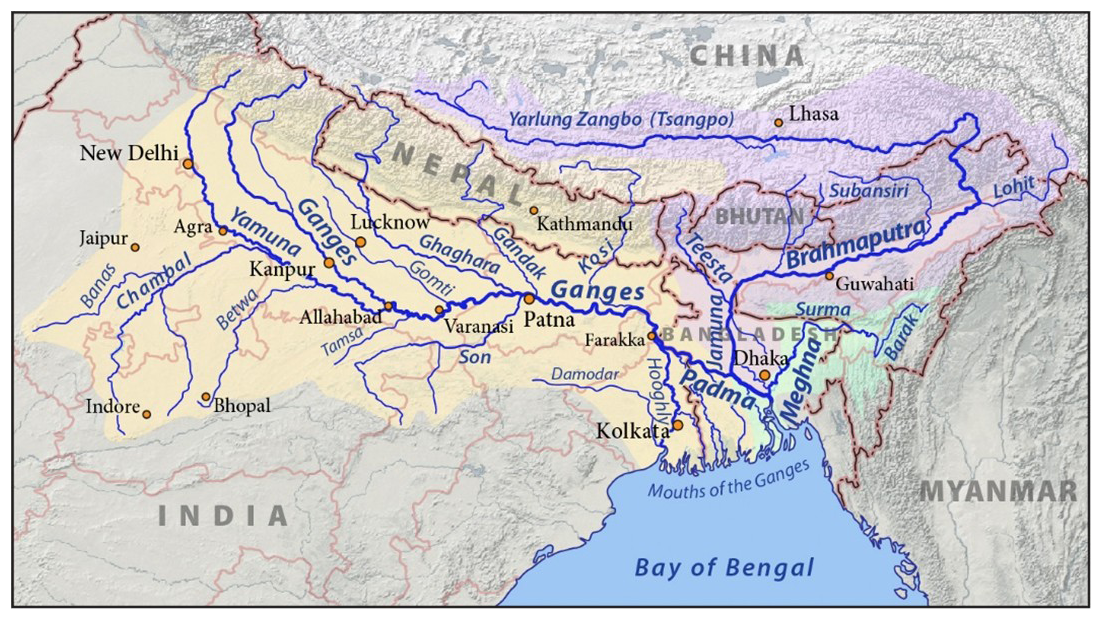
Figure 1Map of the Ganges–Brahmaputra (GB) basin (Source: https://commons.wikimedia.org/wiki/File, last access: 10 July 2025) indicating the transboundary nature of the flood risk.
The Ganges–Brahmaputra basin is known for its ecological, political and institutional complexity, where transboundary flooding adds to the vulnerability due to fragmented governance arrangements, weak multilateral coordination, and the marginalisation of local and community knowledge in decision-making processes (Sahana et al., 2024). These disconnections manifest across multiple scales, between upstream and downstream states, national and local actors, and physical and social systems. The result is an inequitable governance landscape that deepens existing vulnerabilities. As Lyu et al. (2023) observe, transboundary river basins often involve a complex web of stakeholders with competing interests, complicating coordinated management. In the Ganges-Brahmaputra basin, downstream countries like Bangladesh face disproportionate risk from upstream practices in India, yet no basin-wide agreement exists to manage flood forecasting, sediment transport, or water releases (Baseer and Iqbal, 2025; López et al., 2020). Despite experiencing severe floods for decades, Bangladesh receives limited access to real-time hydrological data (see Fig. 2A), which India classifies as sensitive (López et al., 2020). As Baseer and Iqbal (2025) argue, this lack of data-sharing critically undermines early warning systems at precisely the moments when cooperation is most needed.
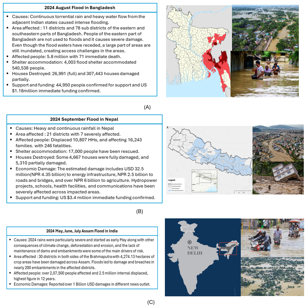
Figure 22024 Floods: Causes, affected areas, population impacted, and economic damages. (A) Bangladesh, Source: https://sheltercluster.org/bangladesh-floods-2024 (last access: 25 July 2025); https://en.wikipedia.org/wiki/August (last access: 25 July 2025); https://www.linkedin.com/pulse/tracking-bangladeshs-2024-floods (last access: 25 July 2025); https://www.aljazeera.com/gallery/2024 (last access: 25 July 2025). Image: Bangladesh floods 2024: A probabilistic outlook; https://www.gettyimages.co.uk/detail/news-photo (last access: 25 July 2025). (B) Nepal, Source: https://sheltercluster.org/nepal-monsoon (last access: 25 July 2025); https://www.npr.org/2024/09/30 (last access: 25 July 2025); https://www.aljazeera.com/news/2024/10/2 (last access: 25 July 2025); https://www.acaps.org/fileadmin/Data (last access: 25 July 2025); Image: https://www.france24.com/en/asia-pacific (last access: 25 July 2025); https://www.aljazeera.com/news/2024/10/2 (last access: 25 July 2025). (C) Assam, India Flooding, Source: https://www.internal-displacement.org (last access: 25 July 2025); https://www.downtoearth.org.in/natural-disasters (last access: 25 July 2025); https://www.cnbctv18.com/india/assam-floods (last access: 25 July 2025); https://news.abplive.com/news/india/monsoon-2024-rains (last access: 25 July 2025); Image: https://news.abplive.com/news/india/monsoon-2024-rains-india-assam (last access: 25 July 2025); https://www.indiatodayne.in/assam/story (last access: 25 July 2025).
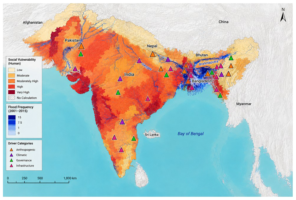
Figure 3Social vulnerability, flood exposure, and drivers of flood vulnerability in South Asia. The figure overlays the social vulnerability index derived from Burton et al. (2022) with flood exposure/frequency data from Matheswaran et al. (2018) to identify areas where high social vulnerability coincides with substantial flood exposure. The coloured triangles represent the four types of flood hotspots – anthropogenic, climatic, governance, and infrastructural – each representing distinct yet overlapping drivers of vulnerability identified through the literature screening (targeted literatures analysis include 62 publications for full text review). The locations of these markers are intended to provide an illustrative and diagnostic representation of the spatial distribution and interaction of reported drivers rather than a predictive, exhaustive, or quantitatively validated assessment of flood vulnerability (see Sect. S1 in the Supplement for further clarification). The figure was produced by synthesising and overlaying the published source-map information, with generative AI (ChatGPT, OpenAI) used to assist with the graphical rendering and visual presentation of the composite map.
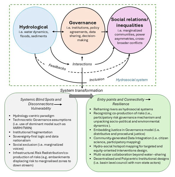
Such complex transboundary flood context and associated vulnerabilities require moving beyond hydrology-dominated applications of basin governance framework, including the way Integrated Water Resource Management (IWRM) is often operationalised in practice. A hydrosocial systems and connectivity lens recognises river basins as interdependent systems where risk emerges from the interplay between environmental processes, social relations, and governance structures (further details in Sect. 3 and Figs. 4, 5), and most importantly, uncovers the disconnection within and between these systems (details in Sect. 3 and Fig. 6). While existing frameworks, such as the hydrosocial cycle (Linton and Budds, 2014; Schmidt and Peppard, 2014) and hydrosocial territories (Boelens et al., 2016) have offered critical insights into the co-production of water and society or the spatialisation of power and infrastructure, hydrosocial connectivity adds a distinct focus. It emphasises how risks are coproduced to shape vulnerability through relational disconnections, between upstream and downstream actors, centralised institutions and local knowledge, and between infrastructure decisions and social justice outcomes, as shown schematically in Fig. 4. Unlike cycle-based approaches that highlight process dynamics or territory-based models that map regimes, connectivity foregrounds the fragmentation and asymmetry that characterise transboundary flood governance. Rather than treating floods as outcomes of hydrological variability or territorial politics alone, hydrosocial connectivity foregrounds how governance fragmentation itself becomes a generator of risk. By explicitly linking relational disconnections to the uneven production of flood vulnerability across borders, the framework extends existing hydrosocial thinking into the domain of transboundary flood governance.
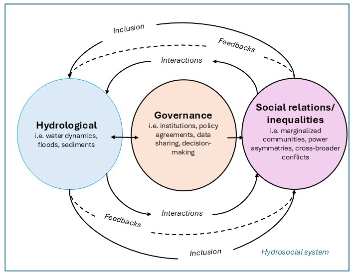
This hydrosocial connectivity concept is particularly suited for transboundary flood governance in regions like the Ganges–Brahmaputra basin, where sovereignty, sediment control, infrastructure, and social exclusion interact in complex feedback loops (i.e. chain reactions or interconnected effects). Conventional hydrological or geopolitical models often fail to capture how these dynamics generate and sustain vulnerability across borders. For instance, in the Brahmaputra basin, floods have submerged over 250 000 ha of farmland and displaced millions (Dubey et al., 2021), revealing how fractured governance and unequal exposure converge to intensify risk, particularly for marginalised communities in downstream areas like Bangladesh and northeast India.
The hydrosocial connectivity approach not only reveals these systemic blind spots but also helps identify entry points for equity-oriented, adaptive governance reforms (details in Sect. 3). Unlike linear, state-centric models that assume risks flows predictably from upstream to downstream, our framework recognizes that vulnerabilities have emerged through nonlinear and dynamic interactions across infrastructures, institutions, and communities. For example, an upstream dam failure may not only generate downstream flooding but also cascade into institutional breakdowns due to disrupted or delayed data sharing or the exclusion of marginalised groups from decision-making, amplifying risks in places far from the original event. Similarly, community coping practices and knowledge often circulate through social networks, rather than strictly along hydrological lines, demonstrating that risks and responses evolve in multiple directions at once. These shifting interdependencies highlights the dynamic character of hydrosocial relations, shifting vulnerability hotspots as infrastructure, governance, and climate variability interact. While existing governance tools offer valuable typologies and technical models, they frequently overlook these transboundary and relational dimensions of flood risk. Global social vulnerability mapping studies, including Fox et al. (2024), integrate social indicators into flood risk models at national and global scales. However, hydrosocial connectivity differs by centring transboundary governance disconnections and conceptualising vulnerability as a relational and political outcome. It explicitly links power asymmetries, data sovereignty, and institutional fragmentation to the production of downstream flood risk across borders. Building on this conceptual contribution, the paper adds further value by integrating spatial hotspot mapping with the lived experiences of affected communities. This empirical review synthesizes and operationalises hydrosocial connectivity, revealing where social and hydrological risks intersect most acutely and how those intersections shift in non-linear, dynamic ways.
This perspective contributes to debates on transboundary water governance in three keyways. First, it reconceptualises the Ganges–Brahmaputra basin as an interdependent hydrosocial system in which flood vulnerability is co-produced through governance disconnections and social inequalities. Second, it advances the concept of hydrosocial connectivity to explain how systemic disconnection, such as institutional fragmentation, power asymmetries, and infrastructure decisions interact dynamically across scales to generate uneven exposure to risk. Third, through a critical synthesis of the literature on India–Nepal–Bangladesh floodplain, it argues for a paradigm shift from infrastructure-heavy hydrological control toward adaptive, justice-oriented governance that recognises the dynamic interlinkages between water flows, social relations, and political power.
The paper proceeds as follows. Section 2 frames the challenge of transboundary flood risk in the Ganges-Brahmaputra basin by highlighting how flood risk is created and increased by disconnections among hydrosocial systems. Section 3 introduces the concepts of hydrosocial systems and connectivity, identifying entry points for adaptive and just governance. Section 4 concludes with implications for policy, research, and practice.
Flood risk in the Ganges–Brahmaputra basin shown in Fig. 1 emerges from the interplay of hydrological extremes, geomorphological complexity, and infrastructure stress, resulting in devastating floods particularly along shared borders (Bhattarai et al., 2024). Figure 2 illustrates the scale and compound impacts of the recent 2024 flooding across the basin-Bangladesh, Nepal and Assam (India), highlighting how transboundary flood vulnerability is co-produced by both hydrological exposure and governance disconnections. In Figure 2A – the Bangladesh case, the 2024 floods inundated vast low-lying deltaic regions, including areas where communities are typically unfamiliar with such extreme flood events. The flooding was triggered by torrential rainfall combined with heavy water inflows from adjacent Indian states. Critically, there was no advance warning or access to essential upstream data, leaving communities unprepared. Nearly 6 million people were displaced, highlighting the severe limitations of national flood infrastructure and early warning systems in the absence of cross-border coordination and data-sharing.
In the case of Nepal (Fig. 2B), intense rainfall and glacial runoff led to flash floods and landslides in mid- and eastern hill districts, where rugged topography and weak disaster coordination mechanisms hampered timely responses. Meanwhile, in Assam (India) (Fig. 2C), embankment breaches and high discharges from upstream dam releases overwhelmed flood defences, inundating urban and rural districts alike. These distinct yet interconnected events underscore the role of fragmented cross-border governance and infrastructure planning in deepening flood impacts. Critically, the lack of a basin-wide forecasting system, agreed and advances planning regard timing of dam releases and uncoordinated or flood responses exacerbated the disproportionateness of vulnerability, with downstream communities bearing the brunt of both natural and institutional failures.
The basin is characterised by strong seasonal variability driven by the South Asian monsoon and Himalayan snowmelt, upstream dam releases, and is further intensified by deforestation and land-use change, which alter runoff regimes and sediment dynamics (Rahayu et al., 2024). However, these biophysical processes interact with deep-seated governance fragmentation, unequal institutional capacities, and socio-political exclusions across borders to produce a complex and uneven flood risk landscape. As a result, the Ganges-Brahmaputra basin is not only one of the most hydrologically dynamic regions in the world but also one of the most institutionally fragmented and socially vulnerable. Understanding flood risk here thus requires an integrated lens that accounts for both environmental variability and the structural inequalities that shape exposure, response, and resilience across borders.
2.1 Physical Hydrological drivers
The Ganges-Brahmaputra basin spans diverse climatic and topographic zones, ranging from the snow-covered Himalayas to the alluvial plains of northern India and Bangladesh. The Brahmaputra and Ganges rivers carry some of the highest sediment loads in the world, leading to rapidly shifting river channels and unstable floodplains (Debnath et al., 2023). Upstream dam releases during peak monsoon periods further complicate downstream hydrodynamics, leading to sudden inundations with limited warning (Shampa et al., 2023). These environmental and anthropogenic factors make flood prediction and management in the basin technically and institutionally challenging.
As shown in Fig. 1, the Ganges–Brahmaputra basin extends across Nepal, northern and eastern India, and into Bangladesh, linking these three countries through shared hydrological systems. The basin encompasses upstream Himalayan catchments in Nepal, midstream plains and infrastructure corridors in India, and low-lying deltaic floodplains in Bangladesh – each contributing to the region's overall flood dynamics. While Fig. 1 illustrates the spatial extent of the basin, Fig. 2 highlights the compound impacts showing how hydrological risks transcend borders, underscoring the urgent need for coordinated, transboundary governance between Bangladesh, India, and Nepal.
The Brahmaputra River, spanning 2900 km and flowing through China, India, and Bangladesh, exemplifies the basin's hydrological dynamics and scale (Dubey et al., 2021; Pradhan et al., 2021). With average discharge levels of around 20 000 m3 s−1, surging to over 100 000 m3 s−1 during peak floods, the river's braided and shifting morphology regularly inundates adjacent floodplains (López et al., 2020). Sediment transport and deposition continually reshape its channels, exacerbating erosion and embankment instability. Mismanaged infrastructure, including embankment breaches, sediment-clogged drainage, and poorly planned flood control measures, further amplify flood risks by diminishing the natural flood conveyance capacity, i.e., the ability of a river channel and its adjacent floodplain to safely transport and dissipate floodwaters without causing damage (Hazarika et al., 2018). In the 2022 Assam floods, embankment breaches along the Brahmaputra displaced more than 2 million people and inundated large parts of the Barpeta and Darrang districts (Shampa et al., 2023).
The basin's hydrology is further complicated by tributary interactions, notably with the Teesta River, which contributes to flash flooding when its peak flows coincide with those of the Brahmaputra (Shampa et al., 2023). These interactions create cascading and asynchronous flood patterns, with variable timing and severity across the basin (Bhattarai et al., 2024; Debnath et al., 2023). Downstream regions particularly, northern Bangladesh and parts of Assam, are acutely exposed due to low-lying terrain and the convergence of upstream flows (Baseer and Iqbal, 2025; Dubey et al., 2021; Rakib et al., 2017). In July 2019, flash floods in Bangladesh's Kurigram district, triggered by upstream discharge from India, affected nearly 700 000 people and damaged more than 150 000 homes (Rakib et al., 2017).
While such hydrological extremes drive widespread inundation, the severity of impacts is shaped by their intersection with social and infrastructural vulnerabilities. High-risk zones marked by chronic erosion, sedimentation, and fluctuating river courses, are often home to marginalised communities living in informal or under-serviced settlements. These areas typically lack resilient infrastructure, reliable flood defences, and timely early warning systems. This convergence of hydrological exposure and social precarity defines the basin's flood hotspots zones where risks are compounded by limited institutional and community capacity to respond effectively. We identified flood vulnerability hotspots by reviewing academic relevant literature and categorised them into themes: (i) Anthropogenic (i.e., urban expansion into floodplains, households with no preparedness plans, land use change, economic vulnerability); (ii) Climatic (i.e., rising trends in peak rainfall, monsoon variability, river course migration, areas within 2 km of river, areas of low elevation, increased flash flood frequency); (iii) Governance (i.e., no disaster protocol across borders, lack of flood shelters, data limitations, limited early warning capacity, no basin wide dam management and flood governance framework, fragmented and scarce data), and (iv) Infrastructural (i.e. embankment breaches, inadequate drainage systems, lack of all-weather roads). Figure 3 maps the spatial distribution of flood vulnerability hotspots across the Ganges–Brahmaputra basin, using these themes as layers that illustrate the interaction between physical hazards and socio-political factors.
These layers reveal that the most at-risk areas are also those marked by chronic governance neglect, poor infrastructure, and limited institutional capacity, particularly in marginalised and borderland regions. This convergence of environmental risk and systemic exclusion underscores how flood vulnerability in the basin is co-produced through both hydrological exposure and entrenched social inequalities.
2.2 Institutional and Governance Fragmentation
Building on the hydrological dynamics outlined in the previous subsection, it becomes clear that the absence of cross-border knowledge-sharing and coordinated governance responses significantly amplifies the social impacts of flooding. These impacts are not only widespread but also deeply unequal, falling most heavily on downstream and marginalised communities. While floodwaters flow freely across national boundaries, governance remains rigidly bounded by state lines, characterised by fragmented institutions, weak coordination mechanisms, and asymmetrical power relations. This disconnects between hydrological continuity and institutional fragmentation undermines the capacity to anticipate, respond to, and recover from transboundary flood events in an equitable and effective manner.
Rapid population growth, informal urban expansion, and unregulated land development have significantly increased human exposure to flood risks across the Ganges-Brahmaputra basin. In Assam, for instance, the population grew from 3.29 million in 1901 to over 31 million by 2011, driving widespread settlement in low-lying floodplains and erosion-prone zones (Debnath et al., 2023). Similar trends are evident throughout the basin, where development decisions often prioritise short-term economic returns over long-term resilience, thereby intensifying both physical and social vulnerabilities. In Guwahati, the largest city in Assam, unplanned urban sprawl and blocked drainage channels have led to chronic waterlogging, even during moderate rainfall events, highlighting the cascading effects of weak land-use governance and infrastructural neglect (Sahana et al., 2024).
Trust and cooperation among riparian states, i.e., countries through which a shared international watercourse flows, remain limited, posing as a major obstacle to basin-wide flood governance. The Teesta River, for example, lacks a comprehensive flood management agreement between India and Bangladesh, despite regularly contributing to flash floods when its peak flows coincide with those of the Brahmaputra (Shampa et al., 2023). As climate change intensifies both the magnitude and frequency of such events, the implications for regional stability and resilience become even more profound (Dubey et al., 2021). Alarmingly, only 16 % of countries sharing transboundary rivers, lakes, or aquifers currently have functional cooperative arrangements in place (Sahana et al., 2024). Formal protocols for joint sediment monitoring, harmonised data collection, and cross-border flood alerts remain absent (Islam et al., 2016; Surinaidu et al., 2020). These gaps undermine early warning systems, impede real-time information exchange, and hinder effective regional planning, particularly at moments when coordination is most critical.
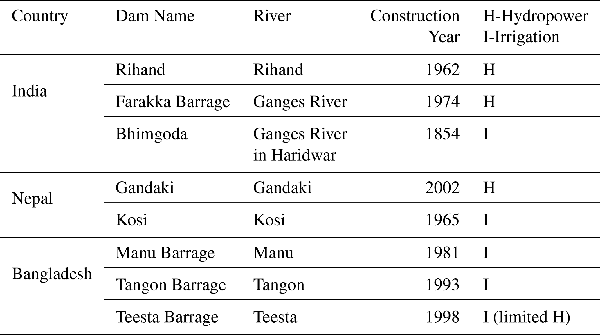
Table 1 lists the large dams and barrages in India and Nepal, including the Rihand, Kosi, and Gandaki projects, primarily serving hydropower and irrigation needs within the Ganges–Brahmaputra basin. In contrast, Bangladesh has no large dams on the main Ganges or Brahmaputra channels (FAO, 2011), relying instead on smaller barrages for irrigation. This upstream–downstream infrastructure imbalance has significant implications for flood timing, sediment flow, and water release coordination, reinforcing asymmetric exposure and limiting downstream resilience.

These institutional deficiencies and blind spots reveal the limitations of narrowly technical, bilateral, or hydrology-dominated paradigms to managing transboundary flood risk. Without inclusive, multi-scalar governance mechanisms, current paradigms remain ill-equipped to address the deeply intertwined physical and social dimensions of transboundary vulnerability.
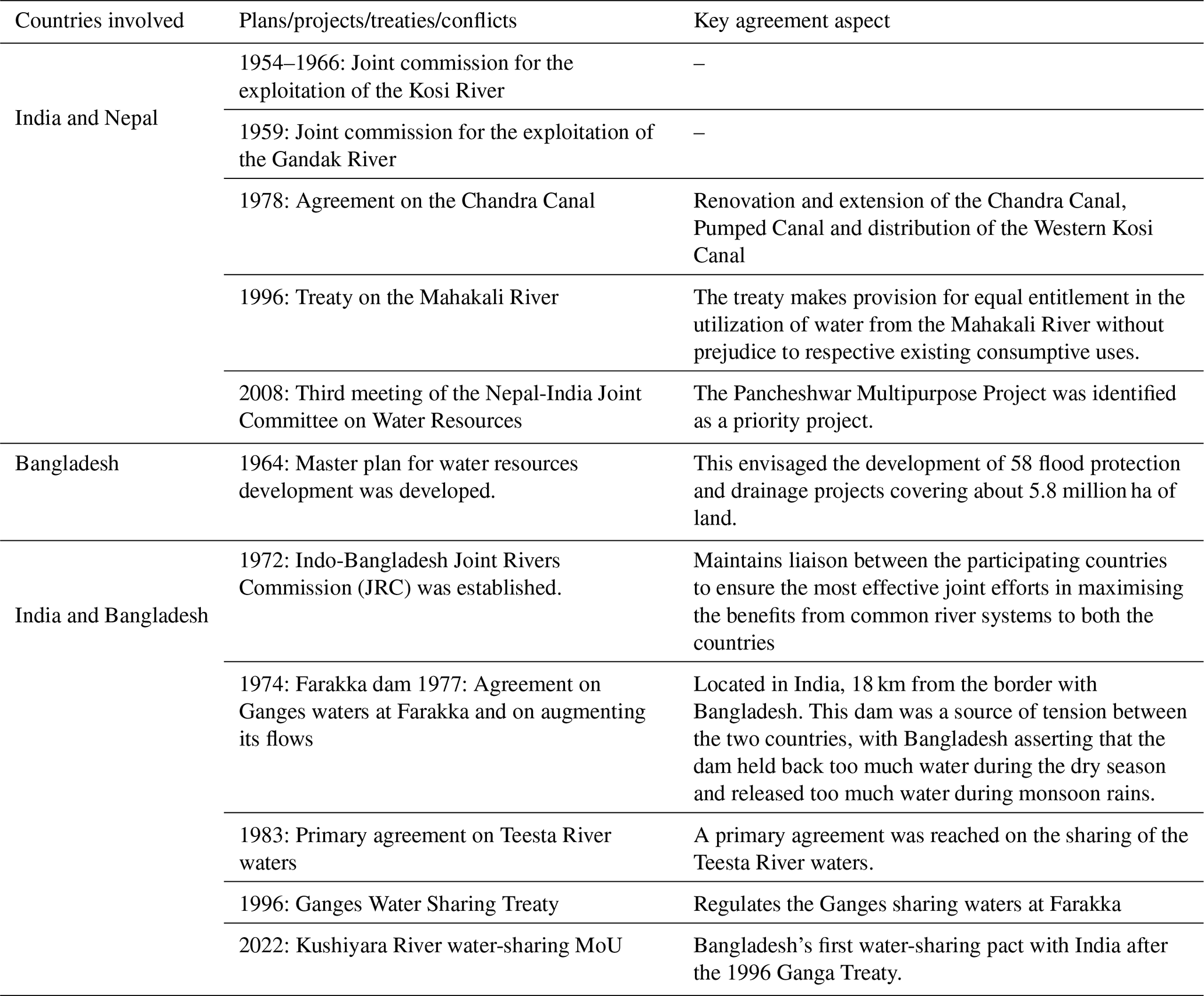
The current architecture of transboundary flood governance in South Asia reflects a legacy of fragmented, state-centric decision-making that is poorly suited to the interdependent realities of the basin. Water diplomacy in the region has historically centred on allocative treaties, most notably the 1996 Ganga Water Treaty between India and Bangladesh, while joint flood management, basin-wide planning, and early warning coordination have remained largely absent (Pradhan et al., 2021). Table 2 outlines the chronology of key transboundary water-related agreements and institutional mechanisms between India, Nepal, and Bangladesh. While these agreements – such as the 1954 Kosi Agreement and the 1996 Ganges Treaty – represent important milestones in regional water diplomacy, they are predominantly allocative in focus and rarely address joint flood management, data sharing, or equitable risk governance. Notably, recent developments such as the 2022 Kushiyara MoU suggest emerging opportunities for more inclusive, risk-responsive cooperation, though implementation remains limited. The timeline reflects both historical inertia and new spaces for negotiation that a hydrosocial perspective could help unlock.
Table 2Chronology of major events in the Ganges-Brahmaputra River Basin between Bangladesh, India and Nepal (Source: FAO, 2011).
Although each country has established its own national disaster management systems, such as India's National Disaster Management Authority (NDMA) and Bangladesh's Flood Forecasting and Warning Centre (FFWC), cross-border coordination remains limited. Collaborative frameworks like the 2011 India–Bangladesh Framework Agreement on Cooperation for Development formally acknowledge water, disaster, and climate change as shared priorities, yet remain underutilised in practice (Pradhan et al., 2021). For example, during the 2020 monsoon season, despite high flood warnings issued in upstream Assam, downstream communities in Bangladesh's Lalmonirhat district received delayed alerts, underscoring the persistent gap in real-time data sharing between the two countries (López et al., 2020). Multilateral frameworks with the potential to support shared flood-risk mitigation, such as the proposed River Basin Management Bill, remain unratified and politically stalled. This disconnects between basin-level interdependence and fragmented policy instruments reinforces the challenges of equitable and anticipatory flood governance in the region.
Emerging ideas like “engineering diplomacy”, where infrastructure projects are used to build bilateral cooperation, offer some promise but fall short without integration of local vulnerability indicators and equitable planning (Pradhan et al., 2021). Similarly, efforts to harmonise data collection and share hydro-meteorological information across borders remain minimal, despite their potential to improve forecasting and coordination (López et al., 2020). Even where national forecasting systems are robust, the absence of upstream data significantly limits their effectiveness. A review by Lyu et al. (2023) found that only 10 % of transboundary river basins in Asia have operational flood forecasting cooperation. Ultimately, governance institutions in the Ganges-Brahmaputra region continue to prioritise sovereignty and control over shared vulnerability and reciprocal resilience. This misalignment fosters reactive rather than preventive risk management, deepening exposure for already marginalised communities in downstream regions such as Bangladesh and northeast India.
This governance disconnection is particularly evident in the Brahmaputra basin, where each riparian country operates under its own national and subnational frameworks. These policies are not only poorly harmonised, but often contradictory when assessed through the lens of integrated basin management (Pradhan et al., 2021). For example, while India and Bhutan prioritise rapid hydropower expansion, Bangladesh focuses on flood protection and irrigation security. Such divergent development agendas regularly generate friction, with downstream states raising concerns over flood risk, disrupted sediment flows, and diminished water security. The construction of the 720 MW Mangdechhu Hydropower Project in Bhutan, for instance, raised alarms in Bangladesh due to its potential impacts on the Brahmaputra's downstream flow regime, highlighting how infrastructure decisions in one part of the basin can directly alter flood dynamics elsewhere (Baseer and Iqbal, 2025).
Addressing these institutional shortcomings requires a shift toward inclusive, basin-wide governance frameworks that reflect the interconnected, hydrosocial nature of flood risk. The next section explores how these fragmented approaches deepen inequalities and systematically exclude vulnerable communities from transboundary resilience building.
2.3 Social (Hydrosocial) Inequalities and community exposure
Flood risk in transboundary river basins is not only the outcome of hydrological extremes and institutional failures, but also deeply shaped by social inequalities and the unequal distribution of power, resources, and representation. In the Ganges–Brahmaputra basin, these inequalities manifest both within and across national borders, affecting who is most exposed to flood hazards, who has access to recovery mechanisms, and who is included in planning and decision-making processes. The concept of hydrosocial inequality here refers to the unequal distribution and access to water resources, shaped by capitalist structures and influenced by socio-political, economic, and environmental factors (Boelens et al., 2016; Rodriguez et al., 2024). As a result, water-related risks are not experienced equally across different populations. Vulnerability is stratified along dimensions of income, caste, gender, land tenure, and geographic location. Marginalised communities often reside in high-exposure zones, such as low-lying floodplains, embankment-adjacent slums, or remote borderlands, where infrastructure is weak and state presence is minimal (Haque et al., 2025). These populations face multiple, overlapping disadvantages: they are less likely to receive timely early warnings, have fewer options for evacuation, and receive limited institutional support for recovery (Baseer and Iqbal, 2025).
Transboundary flood governance in the Ganges-Brahmaputra basin continues to treat risk primarily as a sovereign concern, sidelining the systemic and shared nature of vulnerability. Local authorities and civil society actors lack formal mechanisms to participate in cross-border planning, undermining the incorporation of lived experiences, weakening accountability, and limiting adaptive capacity. Community-led initiatives, such as Apda Sakhiyas in India and local adaptation networks in Bangladesh's Haor Basin, demonstrate strong local capacity for preparedness and response (Haque et al., 2025). However, these efforts remain disconnected from national and regional frameworks, reducing their effectiveness and scalability.
These structural inequalities are compounded by governance systems that routinely exclude local actors from transboundary planning and decision-making. The vulnerability hotspots identified in this study (see Fig. 3) often coincide with regions that receive little policy attention, despite facing the highest flood risks. Traditional knowledge of river dynamics, informal preparedness networks, and coping strategies are largely undervalued in favour of centralised, technocratic responses. As a result, the most vulnerable communities face the greatest exposure to flood hazards yet receive the least institutional support for early warning, relief, or long-term recovery. In Bangladesh's Haor basin, for instance, annual flash floods routinely destroy crops and housing, but early warning systems rarely reach local communities in time, largely due to the lack of upstream coordination with India (Shampa et al., 2023). Without meaningful engagement with these communities, governance systems default to top-down strategies that overlook or even exacerbate existing inequalities.
Despite this, most transboundary flood governance frameworks do not integrate community-scale vulnerability indicators. Risk assessments and planning mechanisms continue to be driven by technical models and national-level priorities, often overlooking locally specific conditions and needs. For instance, in the Brahmaputra basin, hotspot mapping consistently reveals flood impacts concentrated in areas marked by high population density, poor drainage, and limited institutional presence, yet these regions are rarely targeted by coordinated or sustained interventions. In Assam's Dhemaji district, one of the most flood-prone in India, 92.95 % of the population is rural and reliant on rain-fed agriculture, yet the district remains marginal in national planning and risk governance discussions (Debnath et al., 2023).
Community-based initiatives, such as Apda Sakhiyas in Uttar Pradesh and volunteer flood groups in Bangladesh, demonstrate strong local capacity to organise, respond, and adapt to recurrent flooding (Haque et al., 2025). In the Haor Basin, strategies like elevated housing, floating gardens, and informal early warning networks have fostered local resilience in the face of seasonal inundation (Shampa et al., 2023). However, these efforts are typically informal, underfunded, and poorly connected to national disaster management systems, let alone regional transboundary frameworks (Haque et al., 2025). Their exclusion from formal governance processes not only reinforces systemic inequities but also undermines the effectiveness of flood risk management. Crucially, the lived knowledge of river dynamics, sedimentation trends, safe evacuation routes, and historical flood behaviour held by these communities is rarely integrated into upstream planning or early warning systems, despite these populations being the most affected when those systems fail.
Figure 3 illustrates the spatial patterns of vulnerability across the Ganges-Brahmaputra basin, highlighting how hydrological risk converges with socio-political marginalisation in key transboundary regions. These intersecting hydrological, social, and institutional dynamics underscore the urgency of addressing governance gaps that perpetuate fragmentation and deepen inequities in the management of transboundary flood risks. Understanding how these overlapping vulnerabilities are produced, maintained, and made invisible through disconnected governance is central to our hydrosocial lens.
The interplay of hydrological, social, and governance disconnections in the Ganges–Brahmaputra basin illustrates how flood risk is co-produced rather than simply caused by rainfall or river discharge. or instance, during the 2024 floods in Bangladesh, heavy upstream inflows coincided with weak embankments and inadequate drainage infrastructure, amplifying inundation in low-lying districts. Yet the severity of impacts was not only hydrological: fragmented data-sharing between India and Bangladesh meant early warnings arrived too late, while marginalised farming households in the Haor basin – already facing land tenure insecurity and limited evacuation options – were disproportionately affected. Similarly, in Assam, embankment breaches linked to poor maintenance were compounded by rapid, unplanned urban growth into floodplains, overwhelming local authorities. These examples reveal that physical exposure, institutional fragmentation, and social inequalities converge in ways that magnify risk across borders. Recognising these systemic disconnections underscores the need for a new governance lens that treats floods as hydrosocial phenomena, where vulnerabilities are shaped by the interdependencies of rivers, politics, and people.
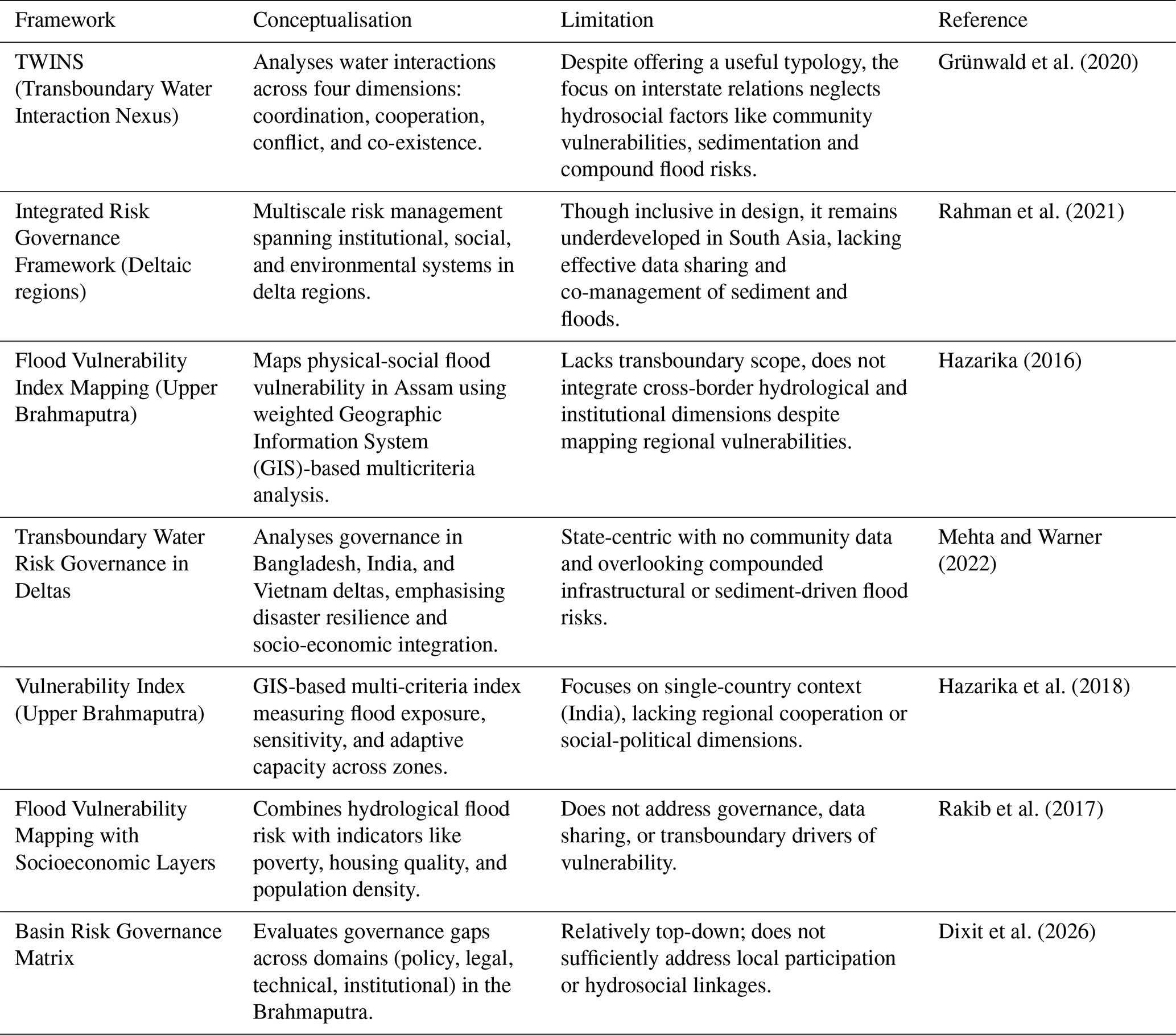
We critically review several governance frameworks, such as the TWINS model (Grünwald et al., 2020), integrated risk governance in deltas (Mehta and Warner, 2022), and regional flood vulnerability mapping initiatives (Hazarika, 2016; Rakib et al., 2017) by assessing their capacity to respond to the compound, unequal, and multi-scalar nature of flood risk. As summarised in Table 3, while these existing frameworks such as TWINS, flood vulnerability mapping, and deltaic governance offer useful analytical tools, they largely fail to engage with the relational and political dimensions (i.e. institutional, diplomatic and power relations, see details in De Stefano et al., 2017) of transboundary flood risk. Most frameworks prioritise institutional coordination or physical exposure but underplay justice, data asymmetry, and community exclusion. These omissions are not just conceptual oversights, they have visible implications, for example, reinforcing up-stream-downstream inequalities, producing blind spots in hotspot identification, and limiting the inclusion of marginalised communities in adaptation planning. In practice, this means that governance responses risk reproducing the very vulnerabilities they aim to address. Such outcomes underscore the need for an alternative approach – one that not only identifies systemic disconnections conceptually but also addresses their practical consequences by placing equity, accountability and participation at the centre of water governance.
Table 3Comparative review of selected frameworks for transboundary flood and water governance, highlighting limitations in addressing hydrosocial inequality and cross-border connectivity.
Our proposed framework fills these gaps by reconceptualising flood vulnerability not simply as a hydrological or political challenge, but as a hydrosocial phenomenon, shaped by systemic disconnections between people, places, and institutions across national borders. By embedding principles of justice, local knowledge, and multi-scalar coordination into transboundary governance, we offer a more equitable, actionable, and adaptive approach to building resilience in one of the world's most flood-prone regions.
3.1 Framing the need beyond the technocratic paradigm
Transboundary flood risk is co-produced across borders, yet decision-making remains bounded by national sovereignty. This disconnection is especially acute for lower riparian regions like northern Bangladesh and Assam, where communities face recurrent flooding but have limited influence over upstream infrastructure development, data sharing or early warning systems (López et al., 2020). This disproportionate exposure and vulnerability reflect a broader pattern of hydrosocial inequality embedded in fragmented governance regimes.
Mainstream paradigms such as Integrated Water Resources Management (IWRM), widely adopted for basin wide management and explicitly promotes cross-sectoral integration and coordinated development, stakeholder participation and equitable water allocation. In theory, IWRM represents a shift away from purely sectoral or infrastructure-driven approaches toward more participatory and integrated governance. IWRM assumes that coordination across sectors and states will naturally deliver equitable outcomes (Gädeke et al., 2022; López et al., 2020; Mehta and Warner, 2022). However, in practice IWRM, in particular context of transboundary flood governance, purely rely on technical optimisation, state-centric planning, treaty-based allocation and sidelining social inequalities and local knowledge. This creates a paradox: frameworks designed to “integrate” often reproduce disconnections, by overlooking how power, exclusion, and justice shape vulnerability (Mehta and Warner, 2022; Pansera, 2024).
For example, basin-level planning under IWRM rarely addresses why downstream communities may lack access to timely warnings, or how infrastructure decisions in one country exacerbate risks for marginalised groups in another. In many transboundary context, IWRM connects institutions and hydrology, but struggles to systematically incorporate the lived realities of vulnerability and power asymmetries,
This paradox is evident in South Asia, for instance, IWRM-inspired negotiations on the Teesta River have centred on interstate water allocations and technical regulation (Tables 2 and 3), while neglecting how sudden upstream releases combine with monsoon peaks to devastate downstream farmers who often receive no timely warnings. Similarly, in the Brahmaputra basin, basin-scale planning has prioritised hydrological data harmonisation and infrastructure coordination but overlooked the lived realities of communities affected by embankment breaches, sediment dynamics, and uncoordinated dam releases. These cases show that while IWRM integrates water flows and institutions, it remains disconnected from the social and political dimensions of vulnerability. This lack of connection underscores the need for a hydrosocial connectivity approach, not to replace IWRM, but as an analytical lens that diagnose why participatory and integrative principles embedded within IWRM frequently fail and further assess how risk is produced at the intersection of hydrological extremes, governance fragmentation, and social inequality to translate into equitable flood governance outcomes.
3.2 Conceptual Foundation: What is Hydrosocial Connectivity?
Central to this paper's contribution is the conceptual development of hydrosocial connectivity as a diagnostic extension of hydrosocial system thinking. We define hydrosocial connectivity as the interdependent, dynamic, and multi-scalar linkages between water flows (hydrological processes), institutional arrangements (governance), and community practices (social relations/inequalities) that extend across physical and political boundaries (Fig. 4). Unlike broader calls for holistic or integrated water governance, this concept is explicitly analytical, it identifies where and how connections fail, weaken or become asymmetrical, and examines how such disconnections reproduce vulnerability in transboundary river basins.
This concept builds upon but is distinct from frameworks such as the hydrosocial cycle (Linton and Budds, 2014) and hydrosocial territories (Boelens et al., 2016). While these approaches have been instrumental in revealing the co-production of water and society vulnerabilities, their analytical focus does not always sufficiently address the institutional fragmentation and cross-border governance gaps that shape transboundary flood risk. The hydrosocial cycle foregrounds relational processes but offers limited tools to interrogate how sovereign boundaries and fragmented policy domain become barriers to real-time data sharing or coordinated flood response. Similarly, hydrosocial territories highlights spatial regimes of power and infrastructure, however, tend to focus on bounded socio-political formations, offering less analytical frame for diagnosing cross-border asymmetries in early warning systems, upstream–downstream risk redistribution, or multilateral planning. In practice, these conceptual blind spots can contribute to governance approaches that recognise power and co-production in theory while leaving institutional and legal silos, and transboundary accountability gaps underexplored.
Hydrosocial connectivity advances this dialogue by foregrounding the connections or disconnections between hydrological flows, governance systems, and social relations across scales. Rather than centring primarily on co-production or territorial configurations, it emphasises how institutional misalignments, data-sharing discontinuities, and power asymmetries shape the distribution of flood risk. By making these uneven linkages visible, hydrosocial connectivity provides a diagnostic lens that connects systemic disconnections directly to justice outcomes and governance capacity in transboundary contexts. Hydrosocial connectivity recognises rivers as not merely physical systems but as socio-political constructs, shaped by infrastructure, institutions, and everyday practices (Yang and Huang, 2024). It shifts the governance focus away from discrete, technocratic interventions towards an understanding of how water flows are entangled with power, exclusion, and asymmetrical decision-making. This framing challenges upstream–downstream binaries, recognising that risks propagate through feedback loops, such as upstream sediment trapping intensifying downstream erosion, or data-sharing gaps in one country undermining early warnings in another (Gädeke et al., 2022).
Importantly, hydrosocial connectivity reframes vulnerability not just as a product of hydrological hazards alone, nor simply as socio-economic disadvantage, but as a relational outcome produced through the interactions among hazards, institutional neglect, social marginalisation, and governance blind spots. Rather than treating hazards and vulnerabilities as parallel factors, it highlights how they are co-constituted through systemic disconnections. For instance, when inadequate data-sharing or exclusionary planning amplifies the exposure of already marginalised communities, vulnerability becomes embedded within institutional design rather than arising solely from hydrological extremes. In this way, hydrosocial connectivity offers a more nuance lens for understanding how systemic inequalities are reproduced within the governance architectures of transboundary basins.
Figure 5 illustrates the key distinctions between IWRM and hydrosocial connectivity, with the latter capturing the relational dynamics, asymmetry and justice-oriented governance.
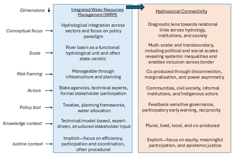
Figure 5An illustration of the key distinctions between Integrated Water Resources Management (IWRM) and our proposed approach of hydrosocial connectivity.
3.3 Diagnosing disconnections: how vulnerability is co-produced
This section illustrates how vulnerability emerges through structural disconnections (also as a blind spot) across institutional scales and geographies. These include:
-
Upstream–Downstream Disconnections: For instance, flood alerts issued in upstream Assam often fail to reach downstream Bangladeshi communities in time – not due to technical limitations but institutional design flaws rooted in sovereignty-first governance (Baseer and Iqbal, 2025).
-
Institution–Community Mismatch: Centralised planning and infrastructure projects frequently exclude local knowledge, reinforcing top-down control and ignoring context-specific vulnerabilities.
-
Technical–Lived Knowledge Gaps: Vulnerability assessments tend to privilege satellite data and expert modelling while sidelining lived experiences and traditional knowledge held by flood-affected communities.
These disconnections co-produce hydrosocial vulnerability, with local communities disproportionately affected by decisions taken at distant centres of power. Importantly, these are not isolated dysfunctions, but symptoms of systemic asymmetries embedded in governance regimes.
3.4 Building Connectivity: Entry Points for Resilience
Addressing these systemic blind spots requires shifting from reactive, command-and-control models to justice-oriented, participatory governance approaches. Hydrosocial connectivity enables a governance redesign based on reciprocity, co-production, and participatory knowledge systems. For instance, the Mekong River Commission's participatory planning offers a partial model for incorporation of local perspectives into regional governance (Mehta and Warner, 2022).
Justice, equity, and co-production are more than normative aspirations within the hydrosocial connectivity framework – they translate into concrete governance interventions. Some of the key entry points for operationalizing hydrosocial connectivity inlcude:
-
Participatory Flood Mapping: Integrating community-based data into vulnerability hotspot mapping to reflect real-world risk.
-
Community-Based Flood Monitoring: Embedding local observation networks into national early warning systems, ensuring real-time risk information reaches the most affected communities.
-
Inclusive Institutional Mandates: Restructuring governance bodies to ensure formal representation of downstream, Indigenous, and otherwise marginalised communities.
-
Fair and Localised Funding Flows: Allocating adaptation finance toward decentralised infrastructure and bottom-up planning, particularly in identified hotspot regions.
-
Mandatory Co-Design Protocols: Embedding participatory planning as a condition in transboundary flood governance agreements.
Figure 6 visualises these pathways, showing how disconnections between institute and communities, upstream and downstream actors can be transformed into connective governance strategies via the hydrosocial connectivity model.
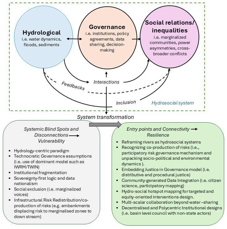
Figure 6Conceptual diagram of transboundary flood vulnerability through the lens of hydrosocial connectivity.
Hydrosocial connectivity provides both a sharper diagnostic lens and a transformative governance pathway. It repositions risk not as a coordination failure but as a consequence of the invisible infrastructure of disconnection, legal silos, institutional inertia, and political marginalisation. Rather than discarding hydrological expertise, it situates it within social and political contexts, ensuring that local voices shape governance outcomes.
The Teesta River dispute between India and Bangladesh (Table 2) shows how hydrosocial connectivity reframes flood governance. Under IWRM, the Teesta has largely been treated as a hydrological unit to be optimised through treaties, infrastructure, and flow regulation. Hydrosocial connectivity, however, highlights relational disconnections: upstream dam releases, weak data-sharing, and the exclusion of marginalised farmers from early warning systems. It reveals how sovereignty concerns in India translate into delayed alerts in Bangladesh, and how local vulnerabilities are rendered invisible in interstate negotiations.
Similarly, the 2024 Bangladesh floods (Fig. 2A) demonstrate this shift. IWRM would explain the event through hydrological extremes and the need for better forecasting, coordination, and infrastructure. Hydrosocial connectivity shows instead how vulnerability was co-produced by governance fragmentation, poor embankment maintenance, and the exclusion of Haor basin farmers from flood risk/management planning. What appears as a technical failure is reframed as the outcome of institutional asymmetry and social exclusion.
Together, these cases illustrate the added value of hydrosocial connectivity: moving from integration as technical coordination to integration as justice-oriented connectivity. Ultimately, by revealing and addressing systemic disconnections between institutions and communities, upstream and downstream actors, and environmental dynamics and justice imperatives, hydrosocial connectivity offers a powerful conceptual and practical basis for reimagining transboundary flood governance. It shifts the governance architecture from top-down delivery to collaborative knowledge generation and risk-sharing, reconfiguring who decides, who benefits, and who bears the risk. By moving from disconnection to connection between people, places, and institutions, hydrosocial connectivity enables flood governance to become not just more technically effective, but more equitable, anticipatory, and just.
Conventional, hydrology-dominated models of transboundary flood governance remain insufficient to address the complex, unequal realities of vulnerability in shared river basins such as the Ganges–Brahmaputra. Despite advances in technical capacity and the proliferation of regional agreements, systemic blind spots persist, namely, fragmented institutions, exclusionary planning processes, and socio-political disparities that continue to shape flood risk in profoundly unjust ways. Framing these challenges through the conceptual development of hydrosocial connectivity offers both a conceptual and practical shift. Rather than viewing risk as a failure of coordination or infrastructure alone, hydrosocial connectivity foregrounds the relational dynamics between hydrological processes, governance structures, and social inequalities. As developed in this paper, hydrosocial connectivity constitutes a diagnostic extension of hydrosocial system thinking. It does not merely advocate greater integration, rather, it defines where and how connections between water flows institutions, and communities fail or become asymmetrical, and demonstrates how these disconnections reproduce vulnerability across transboundary basins. By explicitly linking governance fragmentation, power asymmetries, and data politics to downstream flood risk, the framework clarifies how injustice is embedded within institutional architectures themselves.
Empirical insights from flood-prone regions like Assam and northern Bangladesh reveal that state-centric, technocratic governance models often marginalise local knowledge, everyday lived experiences, and community agency. These exclusions are not incidental but reflect deep-rooted governance asymmetries and systemic disconnections between upstream decision-making and downstream impacts. In response, we propose a move from systemic disconnection to connectivity, through the following interlinked pathways:
-
Institutional transformation: Shift from bilateral water-sharing treaties toward inclusive multilateral governance mechanisms that embed flood risk coordination, power-sharing, and justice-centred objectives.
-
Integration of community-generated knowledge: Incorporate participatory mapping, historical flood narratives, and grassroots adaptation strategies into basin-scale modelling, planning, and forecasting systems.
-
Equity-centred governance frameworks: Redesign institutions to address both procedural and distributive injustice, ensuring that those most exposed to flood risk are also central to the processes of decision-making and response.
Ultimately, addressing transboundary flood risk in a just and effective manner requires us to reimagine river basins not merely as hydrological systems, but as hydrosocial landscapes, shaped by politics, power, infrastructure, and lived experience. By conceptualising vulnerability as a relational and politically mediated outcome of governance disconnection, hydrosocial connectivity provides both a sharper diagnostic lens and a more inclusive governance pathway, supporting flood management systems that are not only technically effective but also socially just, anticipatory, and capable of transformative resilience.
No data sets were used in this article.
The supplement related to this article is available online at https://doi.org/10.5194/nhess-26-4335-2026-supplement.
TY: Funding acquisition, study conception and design, oversight of data collection, analysis and interpretation of results, and manuscript drafting, editing, and finalization. RC: Literature review, data collection, analysis and interpretation of results, and manuscript drafting and editing. XX: Funding co-lead, review of results, feedback to refine the analysis, and approval of the final version of the manuscript. DMH: Review of results, provision of feedback and comments to refine the analysis, and approval of the final version of the manuscript. IL: Review of results, provision of feedback and comments to refine the analysis, and approval of the final version of the manuscript.
The contact author has declared that none of the authors has any competing interests.
Publisher's note: Copernicus Publications remains neutral with regard to jurisdictional claims made in the text, published maps, institutional affiliations, or any other geographical representation in this paper. The authors bear the ultimate responsibility for providing appropriate place names. Views expressed in the text are those of the authors and do not necessarily reflect the views of the publisher.
This research has been supported by the College of Life and Environmental Sciences, University of Birmingham (Adaptation and Resilience theme Pump Priming Funding grant).
This paper was edited by Mihai Niculita and reviewed by two anonymous referees.
Bakker, M. H.: Transboundary river floods and institutional capacity 1, J. Am. Water Resour. As., 45, 553–566, https://doi.org/10.1111/j.1752-1688.2009.00325.x, 2009.
Baranyai, G.: Emerging Challenges to Transboundary Water Governance, in: European Water Law and Hydropolitics: Water Governance – Concepts, Methods, and Practice, Springer, Cham., https://doi.org/10.1007/978-3-030-22541-4_6, 2019.
Baseer, A. and Iqbal, M. F.: Flood monitoring and reservoir management in the transboundary Chenab River Basin using machine learning and remote sensing techniques, Model. Earth Syst. Environ., 11, 21, https://doi.org/10.1007/s40808-024-02182-1, 2025.
Bhattarai, Y., Duwal, S., Sharma, S., and Talchabhadel, R.: Leveraging machine learning and open-source spatial datasets to enhance flood susceptibility mapping in transboundary river basin, Int. J. Digit. Earth, 17, 2313857, https://doi.org/10.1080/17538947.2024.2313857, 2024.
Biswas, A. K.: Management of Transboundary Waters: An Overview, in: Management of Transboundary Rivers and Lakes, edited by: Varis, O., Biswas, A. K., and Tortajada, C., Berlin, Heidelberg, https://doi.org/10.1007/978-3-540-74928-8_1, 2008.
Boelens, R., Hoogesteger, J., Swyngedouw, E., Vos, J., and Wester, P.: Hydrosocial territories: a political ecology perspective, Water Int., 41, 1–14, https://doi.org/10.1080/02508060.2016.1134898, 2016.
Burton, C. G., Toquica, M., Asad, K. M. B., and Musori, M.: Validation and development of composite indices for measuring vulnerability to earthquakes using a socio-economic perspective, Nat. Hazards, 111, 1301–1334, https://doi.org/10.1007/s11069-021-05095-9, 2022.
Chowdhury, M. A., Nawaz, S., Hossen, M. N., Islam, S. L. U., Habiba, S. U., Karim, M. E., Hossain, M. L., and Kabir, M. H.: A review of flood management in South Asia: approaches, challenges, and opportunities, Handbook of Flood Risk Management in Developing Countries, 302–318, ISBN: 9781000847765, 2023.
Debnath, J., Sahariah, D., Lahon, D., Nath, N., Chand, K., Meraj, G., Farooq, M., Kumar, P., Kanga, S., and Singh, S. K.: Geospatial modeling to assess the past and future land use-land cover changes in the Brahmaputra Valley, NE India, for sustainable land resource management, Environ. Sci. Pollut. Res., 30, 106997–107020, https://doi.org/10.1007/s11356-022-24248-2, 2023.
De Stefano, L., Petersen-Perlman, J. D., Sproles, E. A., Eynard, J., and Wolf, A. T.: Assessment of transboundary river basins for potential hydro-political tensions, Global Environ. Chang., 45, 35–46, https://doi.org/10.1016/j.gloenvcha.2017.04.008, 2017.
Dixit, S., Sen, S., Yasmin, T., Khamis, K., Sen, D., Buytaert, W., and Hannah, D. M.: Integrating SMART principles in flood early warning system design in the Himalayas, Nat. Hazards Earth Syst. Sci., 26, 1251–1268, https://doi.org/10.5194/nhess-26-1251-2026, 2026.
Dubey, A. K., Kumar, P., Chembolu, V., Dutta, S., Singh, R. P., and Rajawat, A. S.: Flood modeling of a large transboundary river using WRF-Hydro and microwave remote sensing, J. Hydrol., 598, 126391, https://doi.org/10.1016/j.jhydrol.2021.126391, 2021.
FAO: AQUASTAT Transboundary River Basins – Ganges-Brahmaputra-Meghna River Basin, Food and Agriculture Organization of the United Nations (FAO), Rome, Italy, https://openknowledge.fao.org/server/api/core/bitstreams/0b663060-87be-4338-9248-58cb9a2bfd8a/content (last access: 10 May 2025), 2011.
Fox, S., Agyemang, F., Hawker, L., and Neal, J.: Integrating social vulnerability into high-resolution global flood risk mapping, Nat. Commun., 15, 3155, https://doi.org/10.1038/s41467-024-47394-2, 2024.
Gädeke, A., Wortmann, M., Menz, C., Islam, A. S., Masood, M., Krysanova, V., Lange, S., and Hattermann, F. F.: Climate impact emergence and flood peak synchronization projections in the Ganges, Brahmaputra and Meghna basins under CMIP5 and CMIP6 scenarios, Environ. Res. Lett., 17, 094036, https://doi.org/10.1088/1748-9326/ac8ca1, 2022.
Grünwald, R., Feng, Y., and Wang, W.: Reconceptualization of the Transboundary Water Interaction Nexus (TWINS): approaches, opportunities and challenges, Water Int., 45, 458–478, https://doi.org/10.1080/02508060.2020.1780854, 2020.
Haque, S. E., Nahar, N., Chowdhury, N. N., Sayanno, T. K., and Haque, M. S.: Geomorphological changes of river Surma due to climate change, Int. J. Energ. Water Res., 9, 113–132, https://doi.org/10.1007/s42108-023-00275-8, 2025.
Hazarika, M. K.: Assessing and mapping flood hazard, vulnerability and risk in the Upper Brahmaputra River basin using remote sensing and GIS, J. Flood Risk Manage., 9, 278–291, 2016.
Hazarika, N., Barman, D., Das, A. K., Sarma, A. K., and Borah, S. B.: Assessing and mapping flood hazard, vulnerability and risk in the Upper Brahmaputra River valley using stakeholders' knowledge and multicriteria evaluation (MCE), J. Flood Risk Manage., 11, S700–S716, https://doi.org/10.1111/jfr3.12237, 2018.
Islam, S. N.: Deltaic floodplains development and wetland ecosystems management in the Ganges–Brahmaputra–Meghna Rivers Delta in Bangladesh, Sustain. Water Resour. Manag., 2, 237–256, https://doi.org/10.1007/s40899-016-0047-6, 2016.
Linton, J. and Budds, J.: The hydrosocial cycle: Defining and mobilizing a relational-dialectical approach to water, Geoforum, 57, 170–180, https://doi.org/10.1016/j.geoforum.2013.10.008, 2014.
López, P. L., Sultana, T., Kafi, M. A. H., Hossain, M. S., Khan, A. S., and Masud, M. S.: Evaluation of global water resources reanalysis data for estimating flood events in the Brahmaputra River Basin, Water Resour. Manag., 34, 2201–2220, https://doi.org/10.1007/s11269-020-02546-z, 2020.
Lyu, H., Tian, F., Zhang, K., and Nan, Y.: Water-energy-food nexus in the Yarlung Tsangpo-Brahmaputra River Basin: Impact of mainstream hydropower development, J. Hydrol.-Reg. Stud., 45, 101293, https://doi.org/10.1016/j.ejrh.2022.101293, 2023.
Matheswaran, K., Alahacoon, N., Pandey, R., and Amarnath, G.: Flood risk assessment in South Asia to prioritize flood index insurance applications in Bihar, India, Geomat. Nat. Haz. Risk, 10, 26–48, https://doi.org/10.1080/19475705.2018.1500495, 2018.
Mehta, A. S. and Warner, J. F.: Multi-level hegemony in transboundary Flood Risk Management: A downstream perspective on the Maritsa Basin, Environ. Sci. Pol., 129, 126–136, https://doi.org/10.1016/j.envsci.2021.12.014, 2022.
Nagendra, H., Bai, X., Brondizio, E. S., and Lwasa, S.: The urban south and the predicament of global sustainability, Nat. Sustain., 1, 341–349, https://doi.org/10.1038/s41893-018-0101-5, 2018.
Pansera, J. N.: International Meuse Commission: 20 years of cooperation, Water Int., 49, 455–465, https://doi.org/10.1080/02508060.2024.2321689, 2024.
Pradhan, N. S., Das, P. J., Gupta, N., and Shrestha, A. B.: Sustainable management options for healthy rivers in South Asia: The case of Brahmaputra, Sustainability, 13, 1087, https://doi.org/10.3390/su13031087, 2021.
Rahayu, H. P., Zulfa, K. I., Nurhasanah, D., Haigh, R., Amaratunga, D., and Wahdiny, I. I.: Unveiling transboundary challenges in river flood risk management: learning from the Ciliwung River basin, Nat. Hazards Earth Syst. Sci., 24, 2045–2064, https://doi.org/10.5194/nhess-24-2045-2024, 2024.
Rahman, K. F., Pal, I., Szabo, S., Pramanik, M., and Udmale, P.: Transboundary water risk governance frameworks in deltaic socio-economic regions: A case study of river deltas in Bangladesh, India, and Vietnam, in: Disaster Resilience and Sustainability, Elsevier, 49–72, https://doi.org/10.1016/B978-0-323-85195-4.00011-1, 2021.
Rakib, M. R., Islam, M. N., and Islam, M. N.: Flood vulnerability mapping to riverine floods: a study on the old Brahmaputra River, Curr. Res. Geosci., 7, 47–58, https://doi.org/10.3844/ajgsp.2017.47.58, 2017.
Rodríguez, C., Serrano, J., Sanchez, R., and Leiva, E.: The hydrosocial cycle and the inequalities in access to water in rural areas of Metropolitan Region of Santiago, Chile, Water 16, 2811, https://doi.org/10.3390/w16192811, 2024.
Sahana, M., Dhali, M. K., and Lindley, S.: Global disparities in transboundary river research have implications for sustainable management, Commun. Earth Environ., 5, 786, https://doi.org/10.1038/s43247-024-01928-0, 2024.
Schmidt, J. J. and Peppard, C. Z.: Water ethics on a human-dominated planet: Rationality, context and values in global governance, Wiley Interdiscip. Rev.-Water, 1, 533–547, https://doi.org/10.1002/wat2.1043, 2014.
Shampa, I. J. N., Hussain, M. M., Islam, M. M., and Zoha, R. H.: Evaluating 2021 extreme flash flood of Teesta River, Hydrol. Res., 54, 1095–1114, https://doi.org/10.2166/nh.2023.122, 2023.
Surinaidu, L., Amarasinghe, U., Maheswaran, R., and Nandan, M. J.: Assessment of long-term hydrogeological changes and plausible solutions to manage hydrological extremes in the transnational Ganga river basin, H2Open J., 3, 457–480, https://doi.org/10.2166/h2oj.2020.049, 2020.
UNEP-DHI and UNEP: Transboundary River Basins: Status and Trends – Summary for Policy Makers, United Nations Environment Programme and UNEP-DHI Centre for Water and Environment, https://unepdhi.org/wp-content/uploads/sites/2/2020/05/GEF_TWAPRB_FullTechnicalReport_compressed.pdf (last access: 10 May 2025), 2016.
UN (United Nations): Integrated Water Resources Monitoring and Assessment in Transboundary Basins: Working Group Report, United Nations Digital Library, https://unepdhi.org/wp-content/uploads/sites/2/2020/05/GEF_TWAPRB_FullTechnicalReport_compressed.pdf (last access: 10 May 2025), 2008.
Yang, J. and Huang, G.: Study on the mechanism of multi-scalar transboundary water security governance in the Shenzhen River, Sustainability, 16, 7138, https://doi.org/10.3390/su16167138, 2024.