the Creative Commons Attribution 4.0 License.
the Creative Commons Attribution 4.0 License.
 | 01 Jul 2026
The long-term hazard cascade of an unprecedented wildfire in a tropical mountain ecosystem
Anthony C. Ross
Yazidhi Bamutaze
Jiayuan Han
Douglas Mulangwa
Andrew Mwesigwa
Emmanuel Ntale
Callist Tindimugaya
Brian Guma
Elisabeth Stephens
Wouter Buytaert
Climate change is driving wildfires to higher elevations, yet the hazard cascades that follow the burning of pristine tropical mountain ecosystems remain largely unexplored. Here, we analyse the long-term cascade following a February 2012 wildfire that burned 31 km2 of forest and wetland in Uganda's Rwenzori Mountains National Park, including sections above 3800 m elevation with no major fire history in 12 000 years. Combining remote sensing, humanitarian records, field surveys and interviews, we document ten major floods since 2012, including two debris floods that required large-scale humanitarian responses. Post-fire increases in erosion and mass movement have widened the River Nyamwamba sevenfold since 2012, breaching copper-cobalt mine tailings and mobilising an estimated 744 000 t of waste into the river. Slow vegetation recovery at high altitudes and positive feedbacks between hazards have prolonged this high-risk state. These findings point to an urgent need to understand where emergent tropical mountain fires can occur, how their impacts cascade downstream, and where early interventions can reduce risk.
- Article
(24700 KB) - Full-text XML
- BibTeX
- EndNote


Climate and land-use changes are driving more frequent and intense wildfires across many tropical ecosystems worldwide (Ometto et al., 2022; UNEP, 2022; Wimberly et al., 2024; Obando-Cabrera et al., 2025). In tropical mountains, fires are burning at higher elevations (Mason et al., 2026; Xiao et al., 2022), which is exposing mature forests and wetlands that are not adapted to burning regimes. Tropical mountain forests cover 1.8 million km2 globally (FAO and UNEP, 2020), and they provide the headwaters of major river systems such as the Nile, Amazon and Mekong to sustain the livelihoods of over 336 million people (Encalada et al., 2019).
Hazard cascades describe networks of interconnected hazard processes, where a primary event initiates a sequence of subsequent hazards through direct or indirect interactions (Gill and Malamud, 2016). Understanding cascade dynamics is essential for risk assessment, as the cumulative impacts of cascading hazards often exceed those of individual events in isolation (Gill and Malamud, 2016). Tropical mountains host multiple hazards, making them susceptible to multi-hazard cascades (Arango-Carmona et al., 2025). Intense convectional rainfall drives flash floods (Encalda et al., 2019), whilst high temperatures at lower elevations encourage the development of droughts, heatwaves and wildfires (Ometto et al., 2022). In addition, their steep gradients, deeply chemically weathered soils and unconsolidated glacial and fluvial deposits also favour landslides, debris flows and high rates of erosion (Arango-Carmona et al., 2025).
Multi-hazard cascades occur when two or more hazards interact through relationships characterised as triggering, probability increasing, or catalysing/impeding (Gill and Malamud, 2016). Triggering interactions are typically short-term, through directly sequenced hazard events such as a lightning storm triggering a wildfire. Probability increasing interactions occur when a hazard affects the environmental conditions in a way that increases the likelihood of subsequent hazards occurring. Wildfires are known to have probability-increasing relationships with a range of secondary hazards due to the destruction of vegetation and changes to the physical, structural and biochemical properties of soil (Vahedifard et al., 2024; Boyer et al., 2022). For instance, the probability of post-fire flash flooding is increased due to vegetation-loss reducing interception and thus increasing effective precipitation (Stoof et al., 2012). Whilst triggering and probability increasing hazard interactions describe how one hazard affects the occurrence of another hazard, catalysis/impedance relationships act upon other hazard interaction pairings. For example, the increased river discharge resulting from wildfires may catalyse “erosion-triggered-mass movements” by adding energy and material to earth flows, and the loss of vegetation in a wildfire-affected area may impede the development of future wildfires triggered by human activities (Shakesby and Doerr, 2006). In practice, hazards often share multiple of these cascading interactions, and their relationships can evolve over time (Gill and Malamud, 2016).
1.1 Post-Wildfire Hazard Cascades
Despite their increasing risk, wildfire hazard cascades in tropical montane regions remain poorly understood. Most existing research comes from temperate systems, where wildfires are known to amplify floods, accelerate erosion, and increase the probability of landslides and debris flows by removing vegetation, altering soil properties and increasing surface runoff (Belongia et al., 2023; Boyer et al., 2022; DeBano, 2000; Doerr et al., 2000; Guerriero et al., 2025; Jordan, 2016; Kemter et al., 2021; Rengers et al., 2020; Swain et al., 2025; Vahedifard et al., 2024; McGuire et al., 2024).
However, there are additional factors in tropical mountains that introduce a unique risk and complexity (Moazeni and Cerdà, 2024; Robinne et al., 2021). First, the fires impact upon an already diverse multi-hazard landscape with many existing hazard interactions (Arango-Carmona et al., 2025; Ometto et al., 2022; Sandwell et al., 2005). Second, many higher-altitude ecosystems within tropical mountains have no history of wildfire, such that mature climax vegetation and pristine wetlands are burned with unpredictable consequences for hydrological processes and ecosystem services (Marengo et al., 2021; Mason et al., 2026; Pivello et al., 2021; UNEP, 2022). Third, a lack of wildfire history means vulnerable populations without lived experience are exposed to new hazards (McCaffrey, 2004; Paton, 2003). Lastly, vegetation recovery at high altitudes is slow due to cold conditions and the presence of vegetation that is not adapted to fire cycles, causing prolonged impacts (Kappelle et al., 1996; Oliveras et al., 2014; Salinas et al., 2021). Given these differences, there is a need to better understand the long-term cascade of tropical montane wildfires at the process level. This is especially true for multi-hazard risk management, as identifying where hazards interact effectively highlights where those interactions can be proactively impeded (AghaKouchak et al., 2018, 2020; Vahedifard et al., 2024).
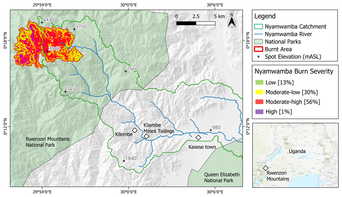
Figure 1The River Nyamwamba catchment and the delineated wildfire burn area within the Rwenzori Mountains, Uganda. Differenced Normalised Burn Ratio (dNBR) between pre- and post-fire Landsat-7 images were used to delineate the extent and burn severity of the February 2012 wildfire. Severity is classified according to the United States Geological Survey's guide (Key and Benson, 2006). Hill shade background created using DEM distributed by OpenTopography, credit: NASA Shuttle Radar Topography Mission (2013).
1.2 Rwenzori Mountains National Park 2012 Wildfire
The February 2012 wildfire in Uganda's Rwenzori Mountains National Park burned 31 km2 of pristine, uninhabited tropical mountain forest and wetlands (Fig. 1) during a brief meteorological drought measuring −3.5 in a 1-month Standardised Precipitation Index (Appendix A). The ecosystem was mature – the fire was the first to affect elevations exceeding 3800 m above sea level in the Rwenzori Mountains for at least 12 000 years (Mason et al., 2026).
The wildfire was followed by unprecedented debris flooding in May 2013 that displaced more than 25 000 people, caused 13 deaths and over USD 4 million in damages (Delforge et al., 2025). Local rainfall records suggested only a 6.6-year return interval (6 h duration), indicating that post-fire landscape changes drove the disaster (Jacobs et al., 2016). We present evidence that, more than a decade later, the Nyamwamba catchment continues to experience flooding, debris floods, mass movements, erosion and water pollution at an elevated level due to fire-induced environmental changes. Because the wildfire occurred in a protected area with no burn history and little subsequent intervention (Mason et al., 2026; Norville et al., 2024), it provides an unparalleled case for this study to characterise the long-term multi-hazard cascade of a tropical mountain wildfire.
1.3 The Study Region
The Rwenzori Mountains are an uplifted metamorphic basement block, with hard, crystalline basement geology creating steep gradients and river profiles that climb to a maximum elevation of 5109 m (UNESCO, 2012). It is the third largest glaciated region in Africa (Hinzmann et al., 2024), with abundant quaternary deposits of unconsolidated glacial and fluvial sediment in its valleys (UNESCO, 2012; Ring, 2008). The Rwenzori Mountains National Park is a UNESCO World Heritage Site dedicated to the protection of biodiverse and unique montane flora, classified into five distinct eco-zones (UNESCO, 2012): tropical mixed broadleaf montane rainforest (<2600 m altitude); bamboo forest (2600–3000 m); an ericaceous zone characterised by dense giant heather trees, giant senecios and giant Lobelia (3000–3800 m); afro-alpine moorland and bogs (3800– 4400 m); and the rock, snowfield and glacier zone (>4400 m).
Higher altitudes within the equatorial mountain range have an annual precipitation of 2500 mm, with two wet seasons (March–May and September–December) where monthly precipitation values exceed 375 mm (UNESCO, 2012). The River Nyamwamba is a major river in the southern part of the Rwenzori Mountains that transports water to its delta with Lake George within the Queen Elizabeth National Park area (Fig. 1).
1.4 Study Scope
This study characterizes the multi-decadal hazard cascade profile of the Nyamwamba River catchment following a 2012 wildfire that burned 31 km2 of pristine tropical mountain forest and wetland in Uganda's Rwenzori Mountains National Park and interprets the implications for regional risk management and broader lessons for tropical montane environments globally. Through an integrated mixed-methods approach combining remote sensing analysis, humanitarian records, field surveys, and semi-structured interviews, we document the long-term interactions between wildfire, flooding, erosion, landslides, and pollution over a 12-year period (2012–2024). The study identifies key hazard interactions using Gill and Malamud's (2016) framework, evaluates entry points for management interventions to mitigate future hazards in fire-sensitive tropical mountain ecosystems, and derives take-aways for the governance and resilience of tropical montane regions facing emerging fire-driven risks.
We adopted a mixed methods approach to evidence changes in multi-hazard processes and risk, combining remote sensing, humanitarian data, field observations and key informant interviews. Cross-validation across methods enabled an abductive approach (Saunders et al., 2016), where emerging insights, such as interview reports of erosion, informed subsequent lines of data collection and analysis.
2.1 Remote Sensing and GIS
2.1.1 Data Acquisition and Pre-Processing
Annual Landsat-7 (2006–2012) and Landsat-8 (2013–2024) Level-2 surface reflectance images at 30 m resolution were downloaded from the United States Geological Survey (USGS) earth explorer and gap corrected, cropped and cloud masked for analysis (Congedo, 2021). For each year, the earliest post-January 1 image with <10 % cloud cover was selected. High-resolution Google Earth Pro imagery was used to measure river width, while Maxar mosaics visualised mine tailings erosion (Maxar Technologies, 2025a, b; Veness and Day et al., 2026).
2.1.2 Burn Severity Classification
Burned area was delineated using the Normalised Burn Ratio (NBR), which combines Landsat 7 near-infrared (Band 4) and shortwave-infrared (Band 7) reflectance (Key and Benson, 2006) to map and quantify the severity of a fire's impact on vegetation and soil. The difference between pre- (9 January 2012) and post-fire (28 March 2012) NBR values (dNBR) provided a relative severity index following USGS protocols (Key and Benson, 2006; Veness and Day et al., 2026).
2.1.3 River Channel Bank Erosion Analysis
Supervised minimum-distance land-cover classifications were applied to annual Landsat images from 2006–2024, using fixed ground control points for five classes: eroded river channel, tailings, oxidised iron, vegetation, and agriculture (Congedo, 2021). Each image was clipped to the Nyamwamba channel, and classified areas were validated against Google Earth area estimates with a relative error of 3.84 % (Veness et al., 2026). Cumulative lateral riverbank eroded area was plotted over time, with classification maps from 2006 and 2021 shown for comparison. River width was delineated in 2010, 2014, 2018, and 2021, at 1 km intervals along 20 km of channel between Kilembe town and Lake George.
2.1.4 Tailings Erosion
Erosion of the Kilembe Mines tailings was assessed using Maxar mosaics from March 2006 and April 2023, with the 33 000 m2 eroded footprint delineated manually. Field measurements in July 2024 using a laser rangefinder provided site dimensions, from which eroded volumes were calculated (see Appendix B).
2.2 Humanitarian Data Analysis
Historic flood events in the Nyamwamba catchment since 2000 were compiled from multiple open sources: the Emergency Events Database (Delforge et al., 2025), the Sendai DesInventar database (DesInventar, 2025), grey literature in ReliefWeb, and a systematic keyword search (“Kasese” OR “Kilembe” AND “flood”) across Google, Google Scholar, and Google News (Google News, 2025). While recent years benefit from expanded monitoring and reporting, the inclusion of diverse sources provided confidence that all major flood events since 2000 were captured by the search.
2.3 Interviews
We conducted twelve in-person semi-structured interviews during field visits in 2023 and 2024, following ethical clearance. Participants were identified through project partners in Kasese District, with snowball sampling to access other stakeholder groups. They included 2 representatives from the Ministry of Water [M – code used to reference in the results], 2 local government officials [G], 1 wildlife authority employee [W], 1 non-governmental organisation worker [N], 2 local industry workers [I], 1 farmer [F], and 3 community residents [R].
Interviews followed a lightly structured topic guide covering hazard processes and causes, changing risk, existing management, and potential alternatives, while remaining flexible to emergent themes (Creswell, 2009; Galletta, 2020; Mojtahed et al., 2014). A full guide is provided in Appendix C. Interviews lasted 30–120 min, were audio-recorded, transcribed, and coded inductively over two rounds of review, with related codes grouped into interpretive themes (Patton, 2015; Saldaña, 2021). While themes are not presented directly, this analysis informed interpretation of hazard processes, impacts, and management options.
2.4 Photographs
Historic photographs of the vegetation pre- and immediately post-wildfire were taken by project partners with permission for research use. Photographs in Appendices E–J were taken by the study authors during a July 2024 site visit.
2.5 Cascade Visualisation
Processes identified through the above methods were integrated into a conceptual diagram of the wildfire's multi-hazard cascade (Patton, 2015), following Gill and Malamud's (2016) framework for hazard interaction types. Evidence underlying each connection is documented throughout the Results and summarised in Table D1 (Appendix D).
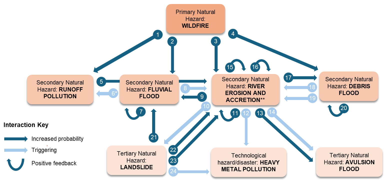
Figure 2Conceptual model of the multi-hazard cascade following the Rwenzori National Park wildfire in February 2012. Interactions between hazards are classified as being (i) triggering, or (ii) probability increasing, following Gill and Malamud's (2016) framework, and (iii) positive feedbacks have been identified. There are numerous catalysing/impeding relationships in this context, which we omit from the visualisation for simplicity but describe key examples in the analysis text. Table 1 describes each of the interactions shown. * Interaction (6) also applies for debris floods and avulsion floods as the driving hazard (Table 1), but they are grouped for simplicity in the visualisation. River channel erosion and accretion of eroded sediment are treated as one hazard in line with UNDRR's Hazard Information Profiles (HIPs), with continuously interacting processes and positive feedbacks (15, 16) along the river's reach (UNDRR, 2025).
We present the multi-hazard cascade caused by the 2012 Rwenzori National Park wildfire (Fig. 2). The following sections describe each of the hazards involved and the interactions they drive, based on evidence from our mixed methods. Results are structured by hazard type: wildfire (Sect. 3.1), flooding (Sect. 3.2), landslides (Sect. 3.3), erosion (Sect. 3.4), and pollution (Sect. 3.5). Identified interactions highlight opportunities where management interventions can impede the cascade, for which we discuss practical solutions at the local and global scales in Sect. 4 (Discussion). The hazard definitions follow the Hazard Information Profiles (UNDRR, 2025) and are clarified in Table D1 (Appendix D). Importantly, here landslides refer to gravitational mass movements directly connected to the river system as shown in Figs. I1 and I2 (Appendix I).
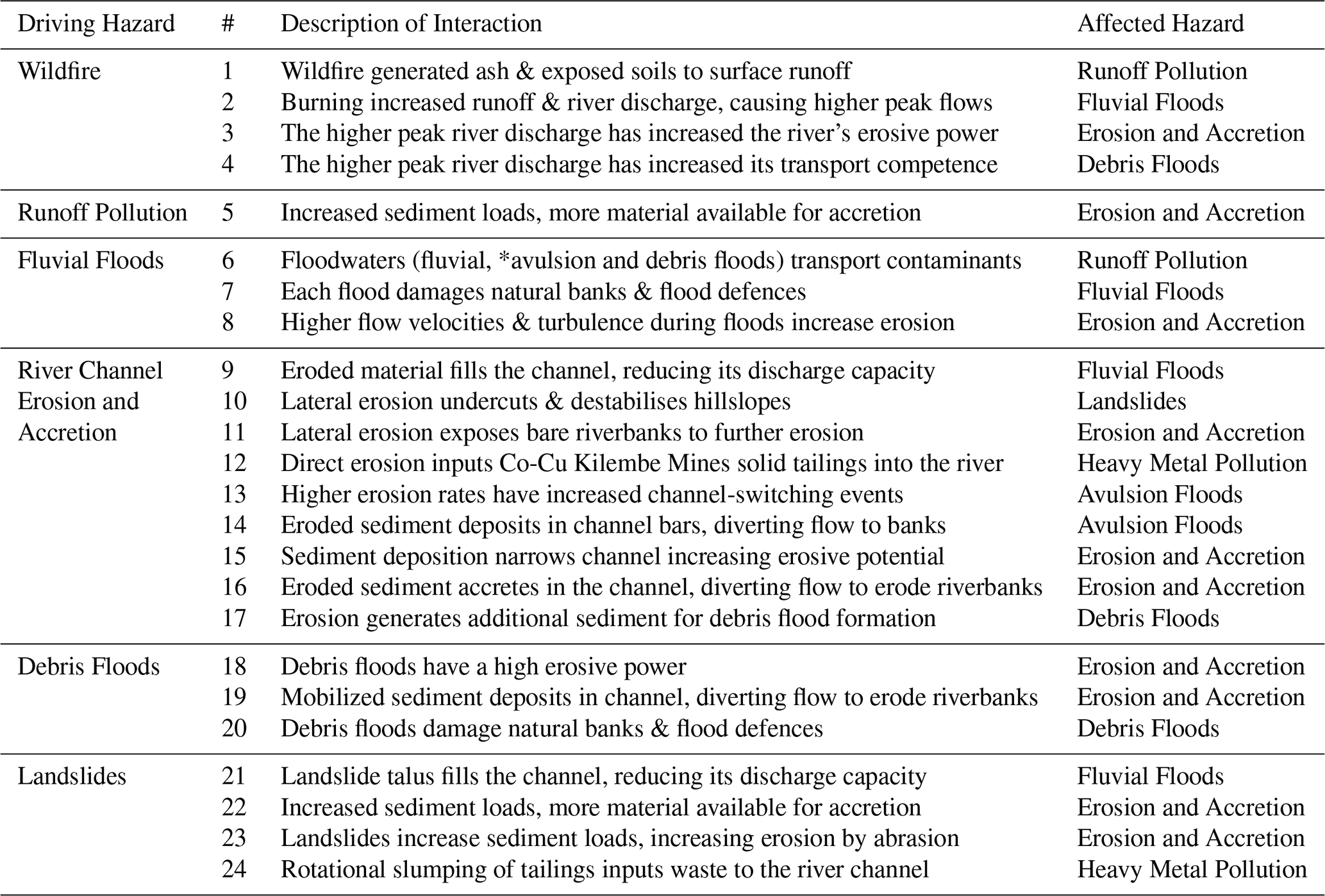
Table 1Description of the hazard cascade interactions in Fig. 2. The study evidence for each interaction is explained in the text and summarised in Table D2 (Appendix D).
3.1 Wildfire
Remote sensing evidence shows a 30.75 km2 burn area for the February 2012 wildfire (Fig. 1), with 87 % of the area burned to a moderate or high severity. The fire occurred during a meteorological drought, with <0.2 mm of precipitation in the 4-weeks preceding the fire (Jacobs et al., 2016) and a one-month Standardised Precipitation Index measuring −3.5 for January 2012 (Appendix A). The fire's cause of ignition is still unknown by the water and wildlife authorities [M1; M2; W1].
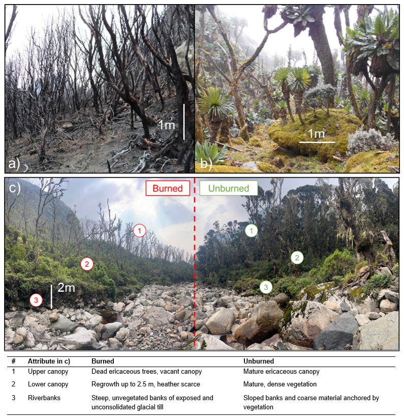
Figure 3(a) Burned ericaceous “heather zone” vegetation 1-month after the wildfire in March 2012; (b) Mature Afroalpine moorland vegetation prior to the wildfire (March 2011); (c) upper course of the River Nyamwamba at 3380 m elevation in July 2024, where the river had acted as a firebreak to provide direct comparison between unburned and recovering burned sections of the ericaceous forest. Scale bars correspond to the tree trunk in (a), the boulder in (b) and the riverbank in (c). The associated table describes the ecological properties of the burned and unburned areas.
The fire burned between 3360–4400 m above sea level, burning climax “heather zone” forest, “spongy” [R1] Afroalpine moorland, and methane-rich bogs [M1] with no recorded history of wildfires (Fig. 3a; Mason et al., 2026; UNEP, 2022). Photographs from March 2012 show indicators of high burn severity (Fig. 3b), while images from July 2024, twelve years later, reveal regrowth limited to a maximum of 2.5 m, with the upper canopy still vacant (Fig. 3c). These slow growth rates and an observed scarcity of heather in the regrowth succession indicate that natural recovery will require several decades (Wesche et al., 2000).
Wildfire-driven Interactions
The wildfire has unidirectional probability-increasing interactions with four secondary hazards. First, burning of soils and vegetation cover increased surface erosion and runoff to river channels, raising turbidity, carrying ash and peat, and introducing biological contaminants. Respondents recalled a strong smell “like methane” after the fire [M1; M2; R1; G1], highlighting wildfire-driven runoff pollution (#1). Second, reduced interception and infiltration capacity increased peak discharges at shorter lag times, driving a marked rise in fluvial flooding (#2; Sect. 3.2). Riverbank erosion has also accelerated due to higher discharges and loss of root cohesion (#3; Sect. 3.4), which, together with higher peak flows after the wildfire, enhanced the conditions for debris flood formation due to greater sediment supply [M1; R1] (#4, #17). These interactions (#1–4) are unidirectional because none of the secondary or tertiary hazards have resulted in further occurrence of wildfires in the catchment.
Additional relationships where the wildfire has catalysed other hazard interactions are numerous, but evidence for these cannot fully be established without intensive monitoring and field experimentation. Based on hydrological theory, some interactions catalysed by the wildfire's effects would include:
-
River channel erosion-triggering-landslide (#10). increased discharge after the wildfire (Moody and Martin, 2001) catalyses the generation of landslides caused by erosive undercutting from higher river erosion rates (Korup and Schlunegger, 2007).
-
Landslide-increasing probability-river erosion (#23). increased discharge catalyses the contribution of landslides to later erosion by transporting landslide talus and using the sediment as erosive tools for abrasion (Sklar and Dietrich, 2001)
-
Debris flood-triggering-river erosion (#18). increased discharge catalyses erosion during debris flood events by increasing the erosive power of the flood (Stock and Dietrich, 2003)
-
Landslide-increasing probability-fluvial flood (#21). increased discharge increases the volume of water accumulating in damming and bursting flood mechanisms after landslides (Costa and Schuster, 1987; Rudoy, 2002)
Although many of the other hazards in the cascade are responsible for additional catalysing relations, we only present examples for the wildfire hazard in this study. This is to emphasise that the fire has not only increased the probability of four secondary natural hazards at the start of the cascade, but it is also catalysing subsequent interactions between other hazards.
3.2 Flooding
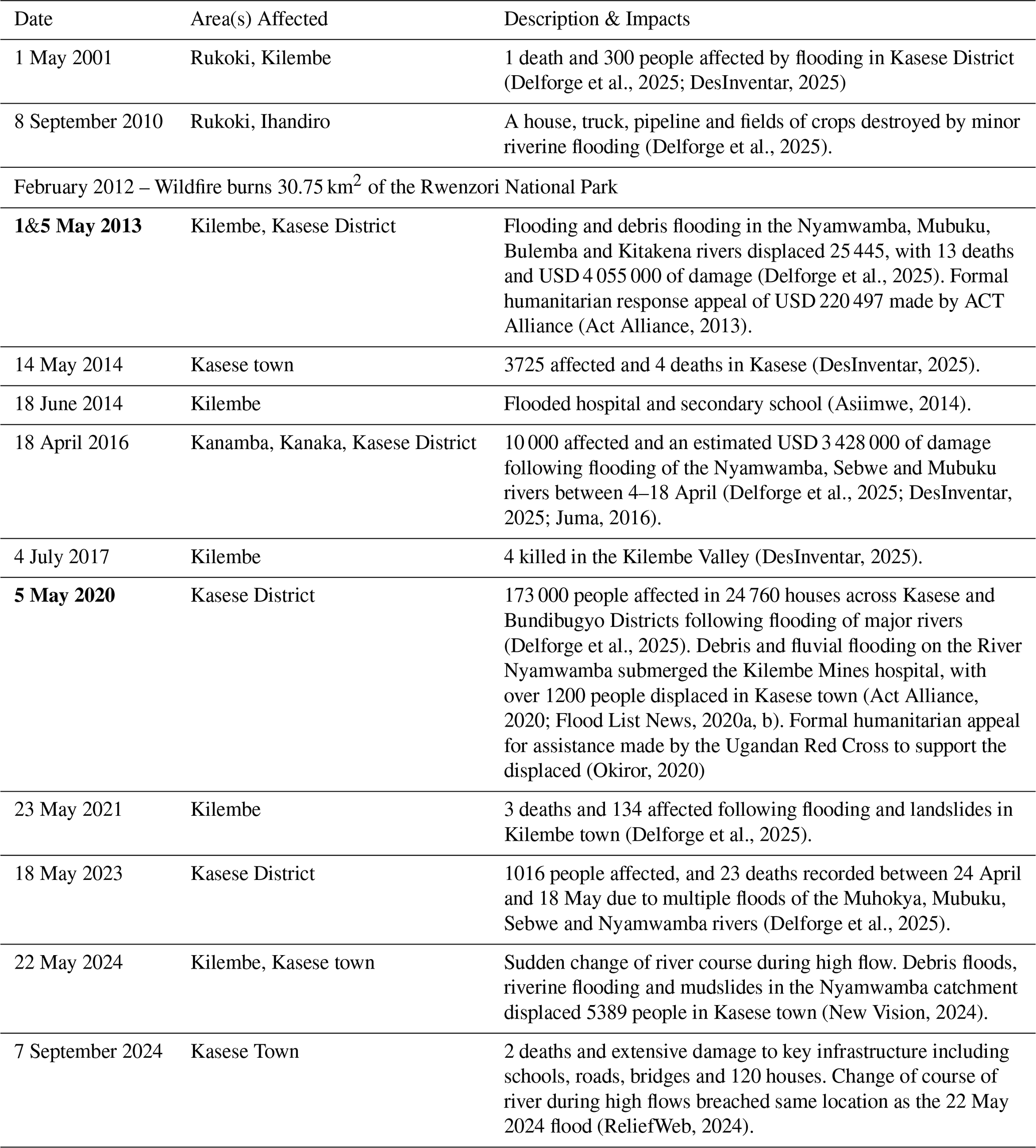
All twelve respondents reported heightened flood risk in the Nyamwamba catchment. Five attributed this directly to changes in hydrological processes caused by the 2012 wildfire [M1; M2; G1; G2; R1], while others cited land use change [N1; W1; R3], climate change [N1; I2], or the discontinuation of dredging [I1; R2]. A government official explained that “the burning is the reason we are now having the floods annually … we know how useful wetland vegetation is in controlling floods, releasing water slowly” [G1]. Similarly, a local guide described the flood-buffering role of the alpine wetlands: “the moss was like a big 1 m thick sponge, it soaked up all the rain … 20 or 30 km2 of rock that was once boulders covered in moss is now bare” [R1]. Table 2 documents ten flood events since 2012, all exceeding in intensity the two documented events during the preceding 12 years, with the 2013 and 2020 debris floods requiring international humanitarian appeals (Act Alliance, 2020; Delforge et al., 2025; Okiror, 2020).
Table 2Timeline of flood events of the Nyamwamba River documented by humanitarian databases and grey literature since 2000. The dates of the two most intense debris flood events are highlighted bold.
The wildfire has increased the frequency and magnitude of fluvial flooding, but also introduced two new mechanisms of flooding, with gravity-driven debris floods and avulsion floods linked to increased mass movement (Sect. 3.3) and erosion (Sect. 3.4) in the catchment [M1; M2].
Fluvial flooding
Vegetation and soil loss following the wildfire reduced interception, infiltration, and water retention capacity, amplifying the river's discharge response to rainfall. The fluvial flooding of unprecedented intensity on 5 May 2013 followed rainfall of only a 6.6-year estimated return period for a 6 h event (Jacobs et al., 2016). Two respondents emphasise that a lack of lived experience prior to this first flood created additional vulnerability among affected communities: “2013 – that was when we were all surprised. I could not believe what I saw” [I1]; “we were not prepared because we had never experienced such magnitude” [M1]. Seven years later, an industrial worker recalled the 2020 event as “an 800 cumecs flood…higher than our professional hydrologist's modelling of a 1000-year flood event” [I2].
Debris flooding
Two floods (2013 and 2020) included debris floods, confirmed in video footage and respondent testimony [M1; R1]. A water authority described “entire mahogany trees coming down as flood load” [M1], while a resident noted “moving rocks two times the size of a minibus” [R1]. Field photos (Appendix G) confirm extensive boulder deposition on the floodplain, and the river has since shifted from a pre-wildfire meandering form with vegetated banks to a braided morphology laden with coarse crystalline sediment (Appendix K).
Avulsion flooding
Elevated erosion rates and sediment deposition have heightened the risk of avulsions [M1; M2]. On 22 May 2024, for example, the Nyamwamba breached its outer bank upstream of Kasese town, inundating Kiwa hot springs and displacing 5389 people [M1] (Table 2).
Flood-driven Interactions
High flows during fluvial and debris floods damage engineered flood defences, increasing their own probabilities of future breaches in self-perpetuating positive feedback (#7; #20; Appendix H). At the same time, their elevated velocities and turbulence generate shear stress and hydraulic action that trigger river erosion and accretion (#8; #18, #19). GIS analysis confirms that the years of greatest erosion (2013 and 2020) coincided with the largest debris flood events [M1; R1] (Sect. 3.4). Fluvial, avulsion and debris floods transport contaminants across urban and agricultural landscapes, driving runoff pollution (#6*; Appendix L). Additionally, debris floods deliver mobilized sediment directly into the river channel, promoting accretion and progressively altering channel geometry over time (#19) [M1; M2; R1] (Fig. 4).
3.3 Landslides
Landslides caused by lateral river erosion undercutting riverbanks and hillslopes (Jacobs et al., 2016) have accelerated since the wildfire due to higher post-fire discharges and sediment loads [I1; M1; M2; R1]. In addition, the initial destruction and exposure of formerly stable riverbanks during the wildfire and 2013 flood has worked to further increase the probability of mass movement into the river [M1; G2]. Previously, graded banks of unconsolidated quaternary sediment were anchored by climax vegetation. Now, vertical riverbanks are exposed to direct erosion and undercutting at sites throughout the river's long profile. As one local government representative describes, “when the floodwaters come down, they remove soil and grasses to expose more boulders, and then you will have a landslide” [G2]. This process is visible in Fig. 3c, where the riverbanks on sections of the burned side are now steep, unvegetated banks of exposed and unconsolidated glacial till.
Landslide-driven Interactions
Landslides increase the probability of fluvial flooding by filling the channel with sediment and reducing the river's discharge capacity (#21). Five respondents have also witnessed a mechanism of temporary landslide damming and bursting “in the space of a few minutes” [M1] during high flow events, from which surges of sediment and discharge activate fluvial floods and debris floods [G1; M1; M2; R1; W1]. As one resident recalls: “suddenly, I heard a roar like a plane taking off at Entebbe Airport. Two landslides cut off the river and created a dam behind it, then soon after there were entire trees pole vaulting over the debris”[R1].
Five respondents describe landslides as being in a positive feedback process with erosion (through reciprocal interactions #23, #22 and #10), whereby landslides add load to the river, accelerating accretion and lateral erosion by diverting flow to the riverbanks and trigger further landslides [R1; M1; M2; I1; G2]. Landslides also trigger heavy metal pollution through the rotational slumping of solid Co-Cu tailings at Kilembe Mines into the River Nyamwamba (#24; Sect. 3.5).
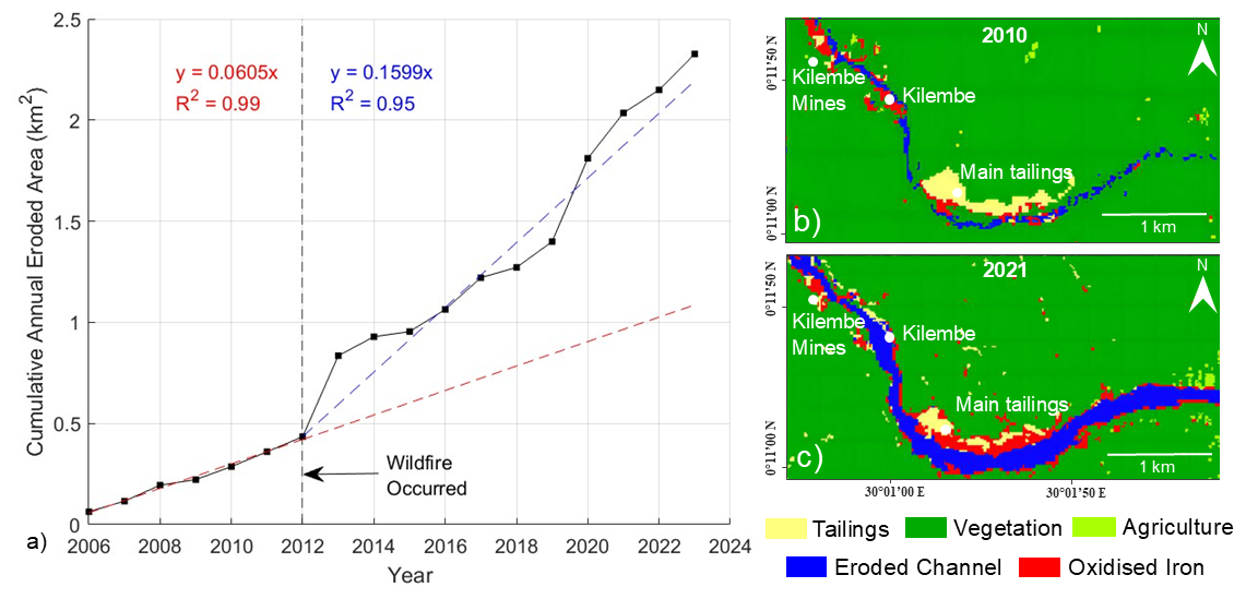
Figure 4(a) Annual cumulative eroded area in a 20 km mid-lower course section of the River Nyamwamba, calculated as the increase in eroded channel area between each year's supervised classification; (b) supervised classification of a February 2010 Landsat-7 image; (c) supervised classification of a February 2021 Landsat-8 image.
3.4 River Channel Erosion and Accretion
The cumulative annual eroded river channel area (Fig. 4a) shows a sustained increase in the river's rate of erosion by a factor of 2.64 following the 2012 wildfire, and the average middle-lower course channel width has increased sevenfold between 2010–2021, from 16.9 to 123 m. Rapid erosion has destroyed agricultural land [M1; M2; G1; G2], residential property, and critical road infrastructure [M1].
Erosion and Accretion-driven Interactions
Since the wildfire, accelerated lateral river channel erosion has shifted the river channel closer to populated areas of Kasese town and eroded debris has filled the channel via deposition, reducing its discharge capacity. Together, these erosion and accretion processes increase the probability of urban flooding in Kasese town [R1; G1; G2; M2; I2; R3] (#9). Accretion also increases the probability of avulsion flooding, as exemplified by the May and September 2024 floods, by filling the channel with sediment bars that divert flow towards riverbanks [M1] (#13), whilst directly triggering avulsion floods when it breaks through unconsolidated banks [M1; M2] (#14). Contributions of sediment to the main Nyamwamba channel also increase the probability of debris floods [M1; R1] (#17).
Erosional undercutting destabilises slopes and directly triggers landslides (#10), consistent with Jacobs et al.'s (2016) mapping of 14 bank-failure slides during the May 2013 multi-hazard event. This lateral undercutting and exposure of vertical riverbanks is also described by three respondents as putting erosion in self-perpetuating positive feedback, by increasing the probability of further erosion at exposed banks [G1, G2, M1] (#11).
Erosion and accretion are also coupled through reciprocal feedback (#15, #16). Sediment deposition narrows the active channel cross-section, increasing the flow velocity and erosive potential (#15), driving further channel erosion. The eroded material replenishes the sediment supply available for sediment deposition (#16), sustaining this cycle. Together, these dynamics place erosion and accretion in a self-reinforcing feedback loop along the river's reach.
Channel widening breached the Kilembe mine copper-cobalt tailings deposit in 2014, triggering heavy-metal pollution downstream that now presents a major risk to public health (#12; Sect. 3.5).
3.5 Pollution
Immediately after the 2012 wildfire, community members reported increased turbidity and a smell “like methane” [M1] in the river. This is still reported during high discharge twelve years later, which four respondents believe to be due to runoff (non-point source) pollution through exposed bogs and organic-rich glacial sediments in the fire-affected and eroding upper catchment [M1; M2; R1; G1] (#1).
Beyond this diffuse pollution, accelerated river erosion (#12) and landslides (#24) have inputted an estimated 744 000 t of a 15 Mt Kilembe Mines Co-Cu tailings deposit directly into the River Nyamwamba (mapped in Appendix K). Satellite imagery and field photographs show erosional banks, slump scars and new channels within tailings areas, and evidence of acid mine drainage from distinctive iron oxide precipitation (Fig. 3c; Appendix E). Elevated Co, Ni, Cu, Fe, Al, S, Zn, As, Cd and Mn river contamination has previously been attributed to leaching of the Co-Cu mine (Abraham and Susan, 2017; Mwesigye et al., 2016; Mwesigye and Lawrence, 2024; Mwongyera et al., 2014).
Five respondents identified this solid waste pollution as a major concern for public health [M2; W1; G1; G2; R1]. The river is used by 38 % of its adjacent population for drinking, and by many more indirectly through crop-irrigation and groundwater abstraction (Abraham and Susan, 2017; Mukisa et al., 2020). In addition to waterborne risks, long-term contamination of arable soils by deposited mine waste raises concern for food safety [M1; M2; G1; G2]. As one Ministry of Water official noted, “in Kasese District, their teeth are turning brown with yellow patches, and we have been told that many people in this region are ailing with cancer” [M2]. Local environmental managers also expressed concern for downstream ecosystems in Queen Elizabeth National Park and Lake George, where protected flora and fauna may be affected by the pollution and vegetation dieback observed in Kasese town [G2; M1, R1, W1].
Pollution-driven Interactions
Runoff pollution from the burned area transports elevated loads of fine sediment and contaminants into the river channel (#1) [M1; M2; R1; G1]. This increased sediment supply promotes channel accretion as the excess sediment load settles into the river channel (#5).
The intensity and persistence of the Rwenzori hazard cascade highlights how emergent wildfires in mature, fire-sensitive mountain ecosystems can impose long-lasting risks on downstream communities. Recovery in these environments is slow, and positive feedback mechanisms sustain elevated risk. By characterising hazard interactions in full, this study identifies entry points for intervention as management approaches that systematically impede hazard interactions can help unravel cascades (Gill and Malamud, 2016).
The principal way to impede this cascade is at the top (interactions #1–4), by promoting ecosystem recovery and attenuating the elevated runoff and river discharge driving other hazards. In the Rwenzori, authorities implemented a mix of hard engineering, community-centred and nature-based solutions in the lowlands which has saved lives (see Appendix M); however, the prevailing approach to wildfire restoration has been to await natural recovery. This passivity missed a critical window to implement soil stabilisation and runoff attenuation solutions such as mulching, contour felling and forest restoration (Papaioannou et al., 2023; Robichaud et al., 2013; Scheper et al., 2021), and allowed lower canopy vegetation to establish ahead of upper canopy tree species in the ericaceous zone (Fig. 3c). The challenge now is to develop recovery and discharge attenuation solutions in a partially recovered ecosystem. Addressing this requires post-wildfire expert assessment to guide restoration planning and build an evidence-base for financing solutions (Veness and Buytaert, 2025).
In the later stages of the Rwenzori cascade, erosion emerges as a key driver of multiple hazard interactions and positive feedback processes. It has accelerated landslides, amplified debris floods, triggered flooding, and caused a major water pollution hazard now requiring urgent investigation of its scale and health impacts. Stabilising riverbanks is a critical intervention to mitigate erosion and therefore impede its cascading interactions. We recommend integrating existing dredging, levee construction, and nature-based approaches to achieve this (Appendix M; World Bank, 2022). In particular, repositioning coarse sediment to riverbanks can help protect eroding riverbanks, regrade unstable slopes, and create conditions for in-channel vegetation to anchor finer sediments and restore soil, thus mimicking the stable, unburned riverbank morphology seen in Fig. 3c (Sanches Fernandes et al., 2020). These measures are urgent in the mid-catchment to protect communities and limit further mobilisation of solid mine waste, but also advisable in the upper catchment to reduce sediment generation and landslide risk.
The principle of mimicking natural processes to promote post-wildfire recovery has been successfully implemented elsewhere (European Environment Agency, 2025). In New Mexico, Engineering With Nature (EWN) principles were implemented following the 2011 Las Conchas Wildfire to implement low-tech hillslope and in-channel structures including mulch barriers, contour-felled log debris, tree-check dams, and in-channel sediment grade-control features to stabilise slopes and reduce downstream sediment transport (Haring et al., 2021). In Arizona, USA, following the 2019 Museum Fire, alluvial fan restoration through regrading and rock sill installation has a predicted reduction in downstream sediment transport of 70 % (Schenk et al., 2025). Post-fire restoration following the 2020 Cameron Peak Fire in Colorado included post-assisted log structures and beaver dam analogues to attenuate peak flows and promote sediment aggradation in burned headwater streams to replicate the hydrological buffering functions of pre-fire riparian systems (Wheaton et al., 2019; CPRW, 2026; Nichter et al., 2026). Whilst these represent a small selection of examples, the underlying principle of designing interventions to mimic pre-disturbance geomorphological and hydrological processes offers a transferable blueprint for post-wildfire management in significantly altered catchments like the Nyamwamba (Haring et al., 2021; Bombino et al., 2024).
Montane environments globally, especially those without a history of fire, require greater investment in monitoring and research into post-wildfire hazard cascades (Arango Carmona et al., 2025; Mason et al., 2026; Wimberly et al., 2024). The lack of comparable case studies makes it difficult to determine whether the Rwenzori represents an outlier or part of a broader emerging trend; however, the intensity of the Rwenzori cascade, following a burn area of just 31 km2, is a signal to trigger post-fire risk assessments at lower thresholds of burn area and severity when an emergent fire occurs in a fire-sensitive mountain ecosystem (Mason et al., 2026). Expanding research in similar regions may help build an evidence base of comparable events, common cascading interactions and best practices for their management.
This study has characterised a post-wildfire multi-hazard cascade in a tropical montane catchment, demonstrating how the burning of a pristine, fire-sensitive mountain ecosystem can initiate cascading hazards of exceptional intensity and persistence. As fire regimes continue to shift to higher altitudes under climate change, there is an emerging risk of similar hazard cascades for downstream communities in tropical mountain catchments worldwide (Mason et al., 2026).
In Uganda's Rwenzori National Park, in the twelve years after a 2012 wildfire burned 31 km2 of mature forest and peatland, ten major floods with fluvial, debris or avulsion mechanisms occurred, with two debris floods requiring large-scale humanitarian responses. Increased river discharge after the fire caused a 2.64-fold increase in erosion rates and increased the probability of landslides, which have together driven a sevenfold increase in river channel width over nine years. Urban and agricultural areas now face a real-time risk to public health due to the erosion and mass movement of 744 000 t of copper-cobalt solid tailings into the River Nyamwamba since 2014. This discrete escalation of hazards, interactions and impacts is sustained by the slow recovery of vegetation poorly adapted to fire regimes, and multiple positive feedbacks between hazard interactions.
The Rwenzori case highlights a need to recognise post-wildfire hazard cascades as a long-term risk in tropical mountain environments, especially in newly fire-prone areas with no prior history of burning. High-income countries generally have established post-fire risk assessment protocols, such as the Burned Area Emergency Response used in the USA (NIFC, 2026), and the Post Wildfire Natural Hazard Risk Analysis in British Columbia, Canada (Government of British Columbia, 2023). Meanwhile, many low- and middle-income countries still lack standardised assessment procedures at the local or national level. We recommend post-fire risk assessments and research, even for relatively small burn areas, when future fires occur in previously unburned or fire sensitive mountain ecosystems. A better understanding of interactions between hazards identifies intervention points, where interactions can be impeded through early actions that prevent ecosystem impacts from becoming entrenched long-term. To this end, remediation of the burned zone should always be a priority to accelerate ecosystem recovery and attenuate elevated runoff.
More monitoring and research of global case studies is needed to establish the prevalence and behaviour of tropical mountain wildfire hazard cascades at emergent elevations, and best practices for their management. This study has additionally underscored the value of integrating qualitative data and local knowledge into such studies. Interviews were critical to identifying key hazard interactions that would not have been captured through physical or remote data alone. Interdisciplinary research, through close partnerships between academic and local stakeholders, can improve collective visibility on this emerging climate risk and accelerate the development of shared solutions.
ERA5 monthly averaged reanalysis total precipitation data was downloaded from 1974–2024 for the pixel covering to the burned area (centroid coordinates: 0.4° N, 29.8° E; Copernicus Climate Change Service (C3S), 2017). This was processed in MATLAB following McKee et al.'s (1993) method to determine the monthly-SPI for January 2012.
The average original height of the tailings was calculated to be 23 m, assumed to be flat across the original dammed area, which was calculated (32 945 m2) from historic satellite imagery.
This average height (23 m) was multiplied by the eroded footprint area (m2) to get a volume, then volumetric subtractions were made to account for the originally sloped (55°) walls of the tailings dam and the wedges of slumped material yet to be eroded at the foot of the collapsed tailings escarpments. The volume of these wedges was calculated from the slope angle and height of their triangular cross-section, multiplied by their width parallel to the eroded tailings escarpment.
The tonnage of eroded tailings was then calculated by multiplying their estimated volume by their assumed average dry density (1.5 t m−3) based on standard values for copper-cobalt tailings (Williams, 2015).
Background
-
What organisation do you represent?
-
What is your role?
-
What is your experience of hazards in the Rwenzori?
Perceptions of changing hazard risk
-
Do you feel the risk of hazards have changed (in the Nyamwamba catchment)? How?
-
If yes, why do you feel risk is changing?
-
Do you feel the river Nyamwamba/Mubuku/other rivers have changed?
-
If yes, why do you think this change has happened?
Awareness and efficacy of existing management strategies
-
What existing strategies are in place to manage hazard risk in the Rwenzori?
-
Do you feel these strategies are working?
Potential alternative management strategies
-
What strategies do you feel would better reduce hazard risk in the Rwenzori?
-
Why do you think these have not been implemented yet?
-
Do you feel nature-based solutions could be used to manage these hazards?
Table D1Definitions of hazard terminology in this article from the 2025 Hazard Information Profiles (HIPs; UNDRR, 2025).
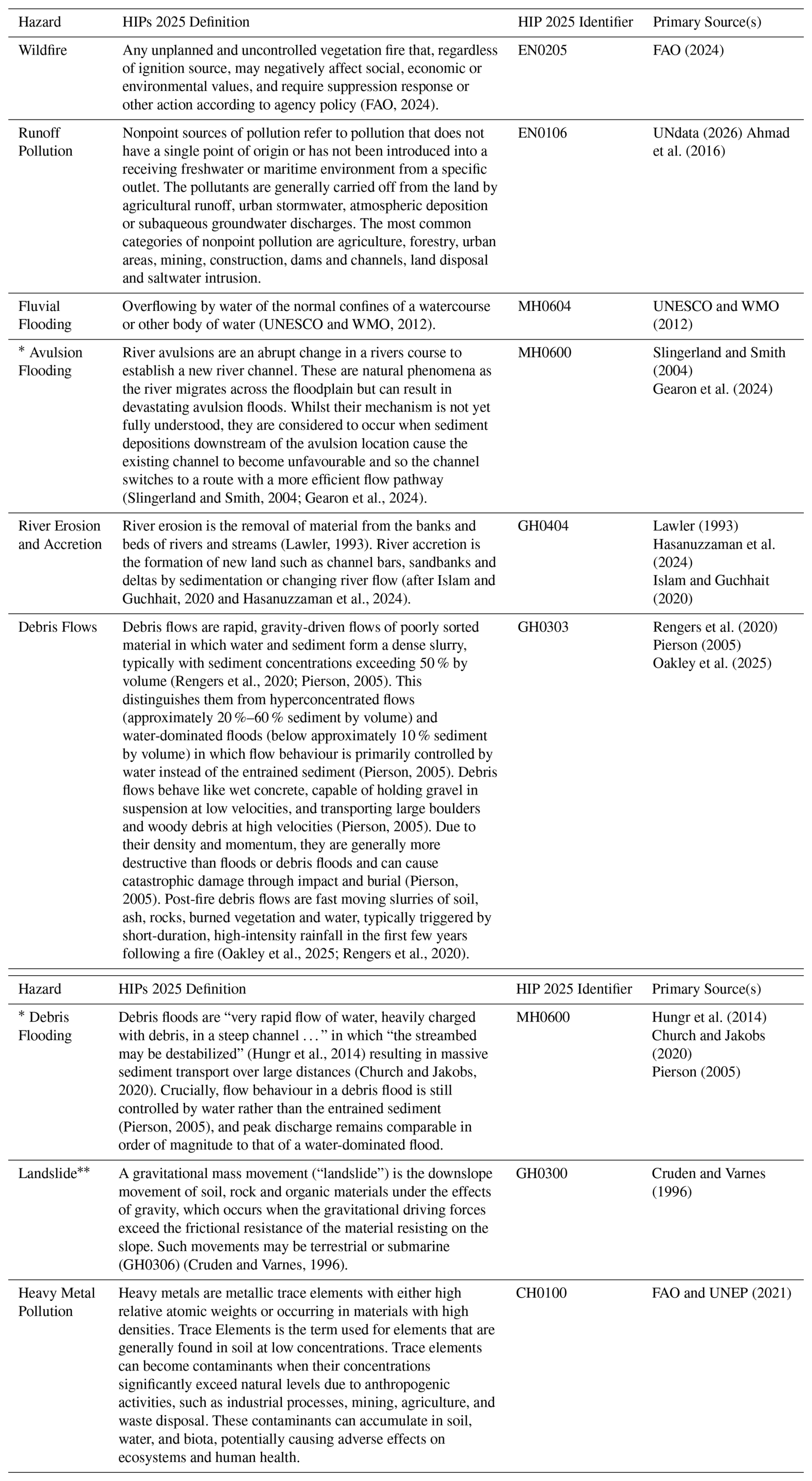
* Both avulsion flooding and debris flooding are profiled under Flooding – MH0600 (UNDRR, 2025) however further distinction using key references between these types of flooding is important here for understanding the hazard cascade and its interactions. Here, we define landslides as those connected to the river system.
Table D2Description of the hazard interactions in Fig. 2 and supporting evidence.
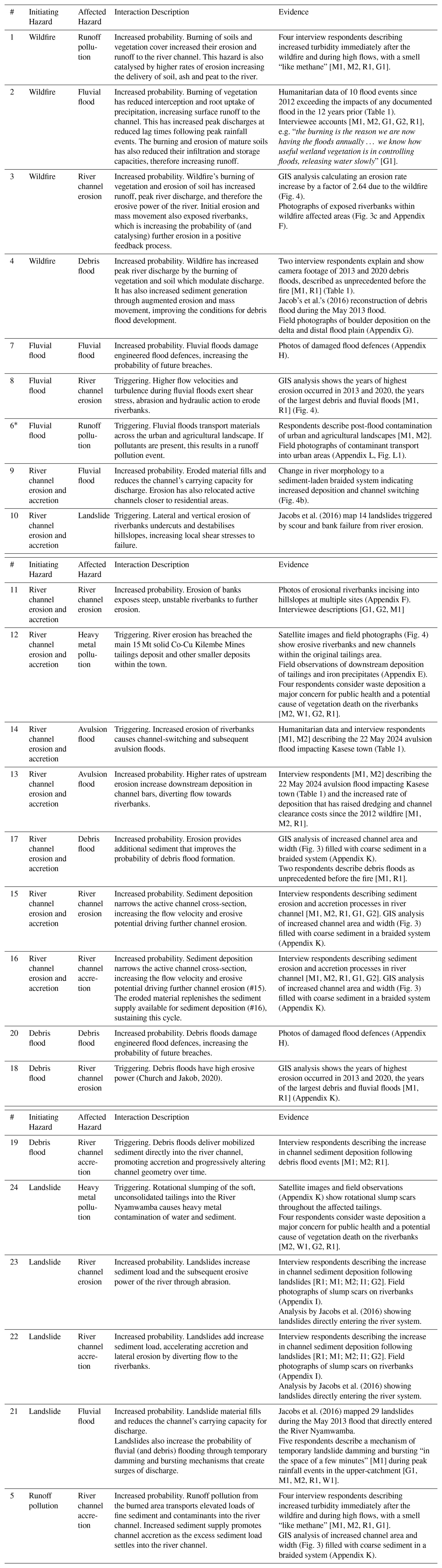
* This is also true of avulsion floods and debris floods.
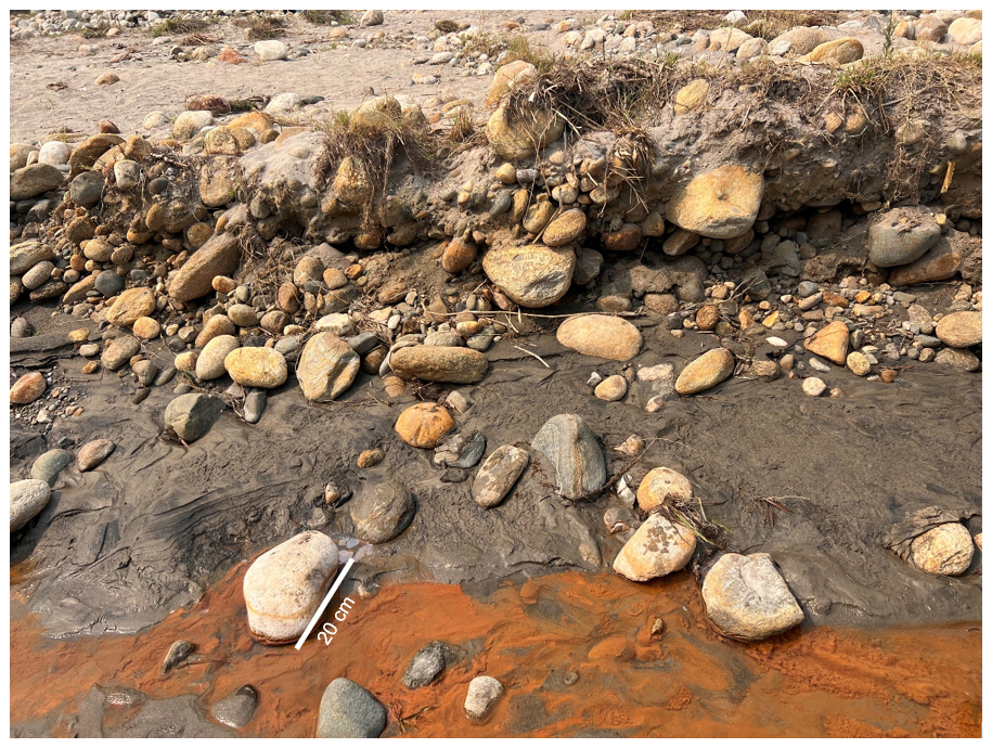
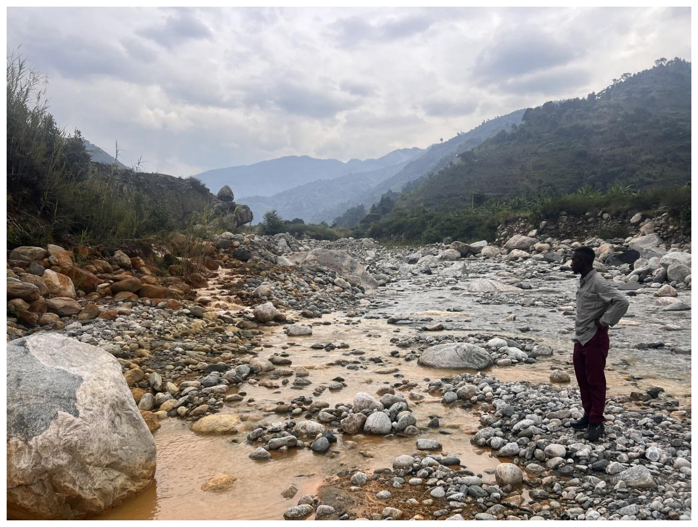
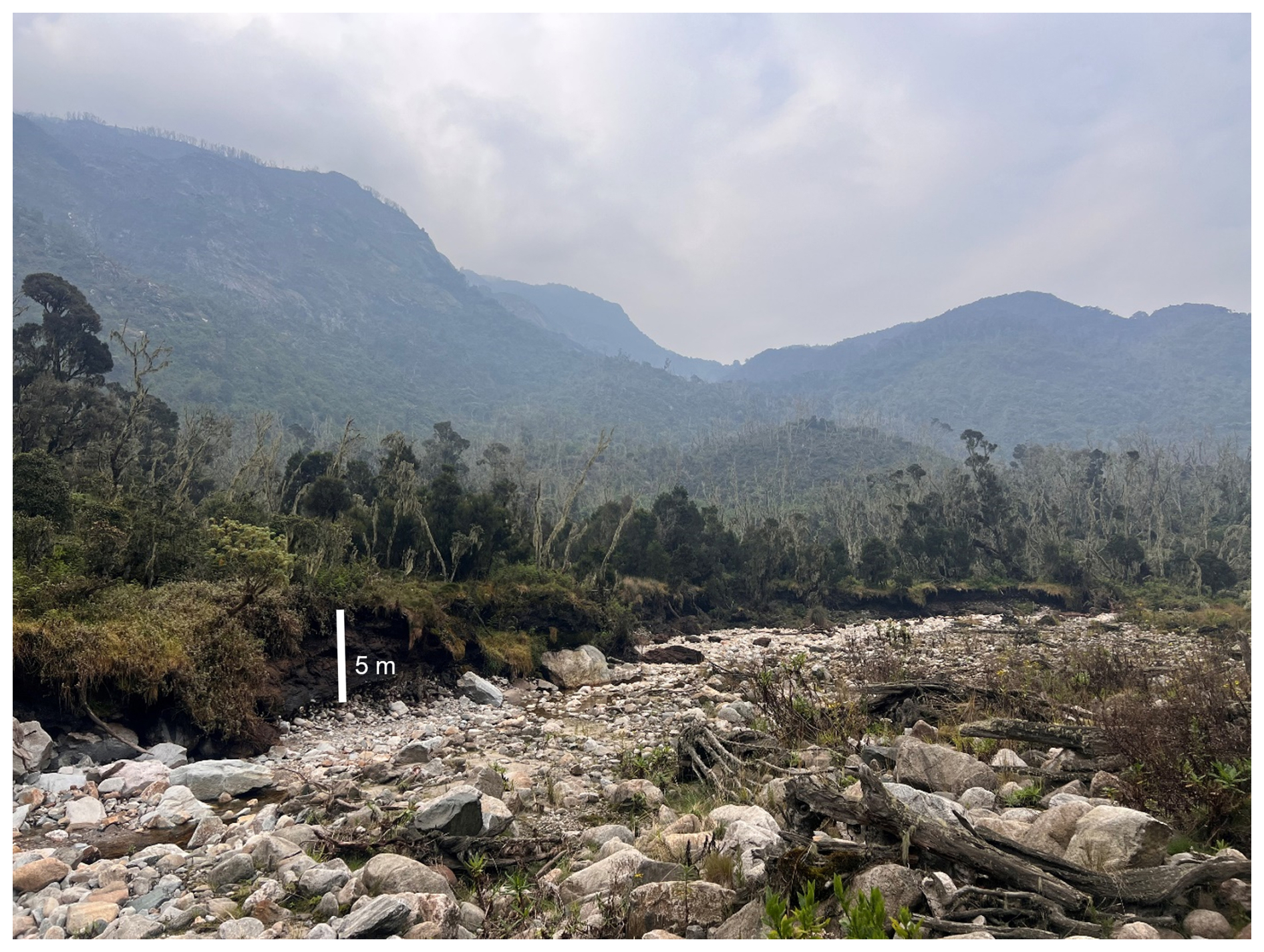
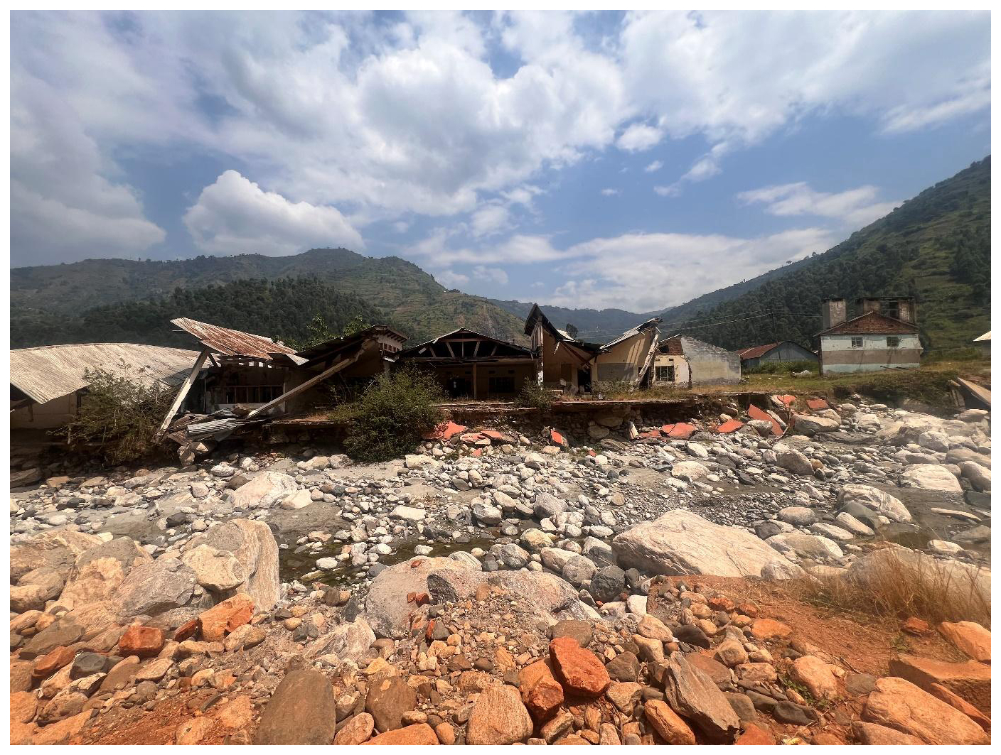
Figure F2Riverbank style erosion of house foundations in Kilembe, 0.20603° N, 30.00822° E – 24 July 2024.
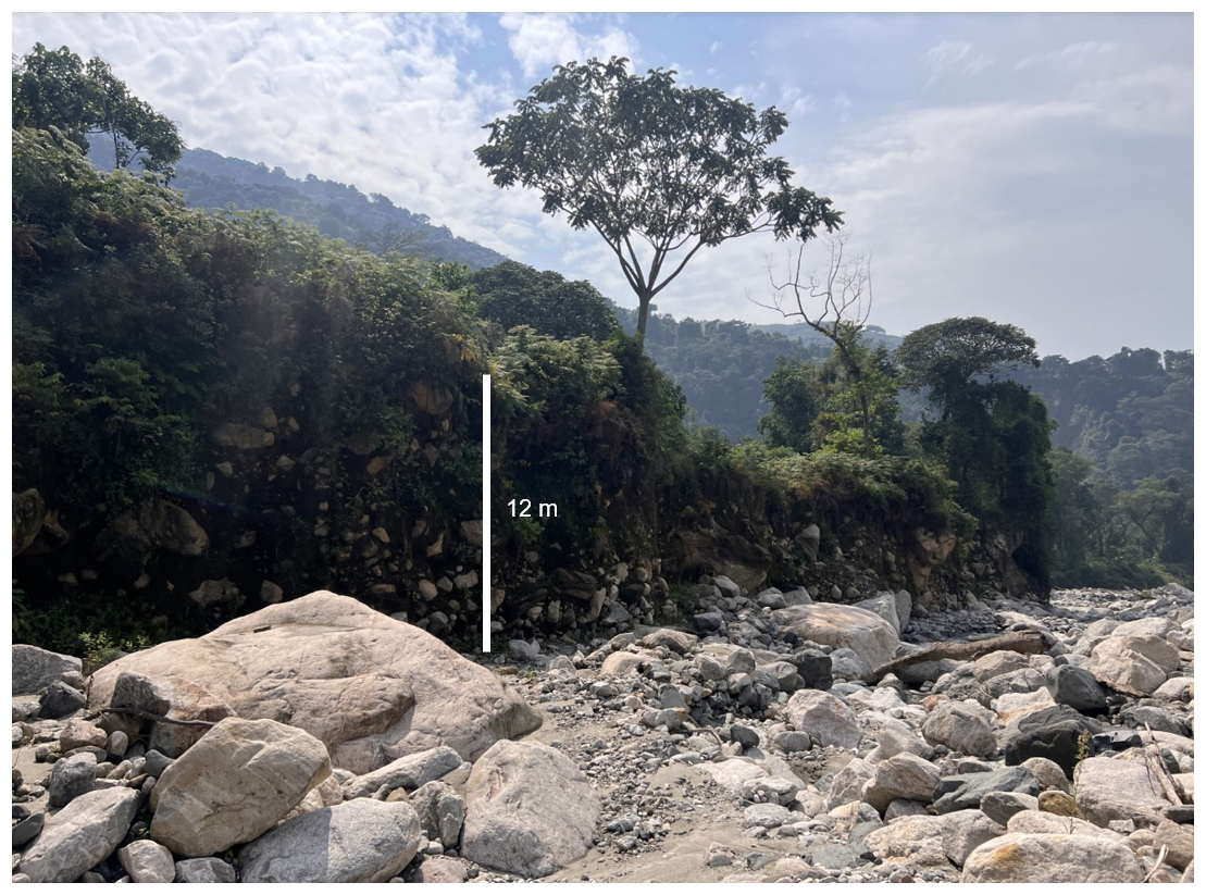
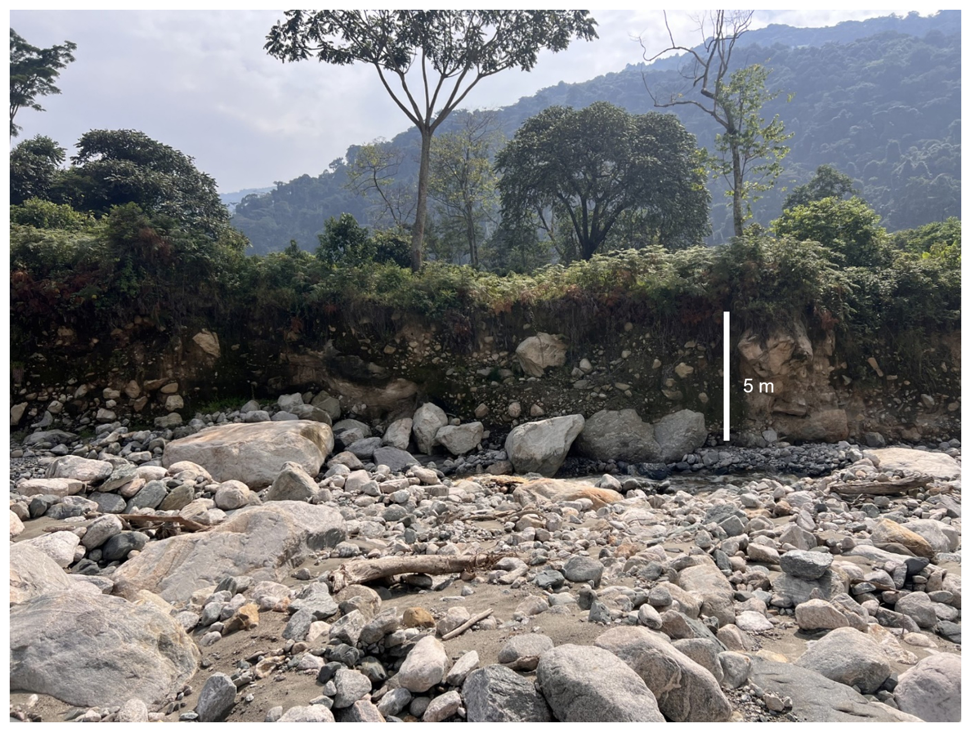
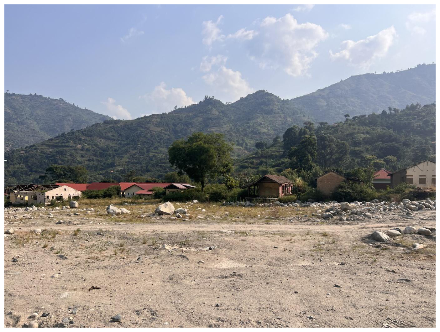
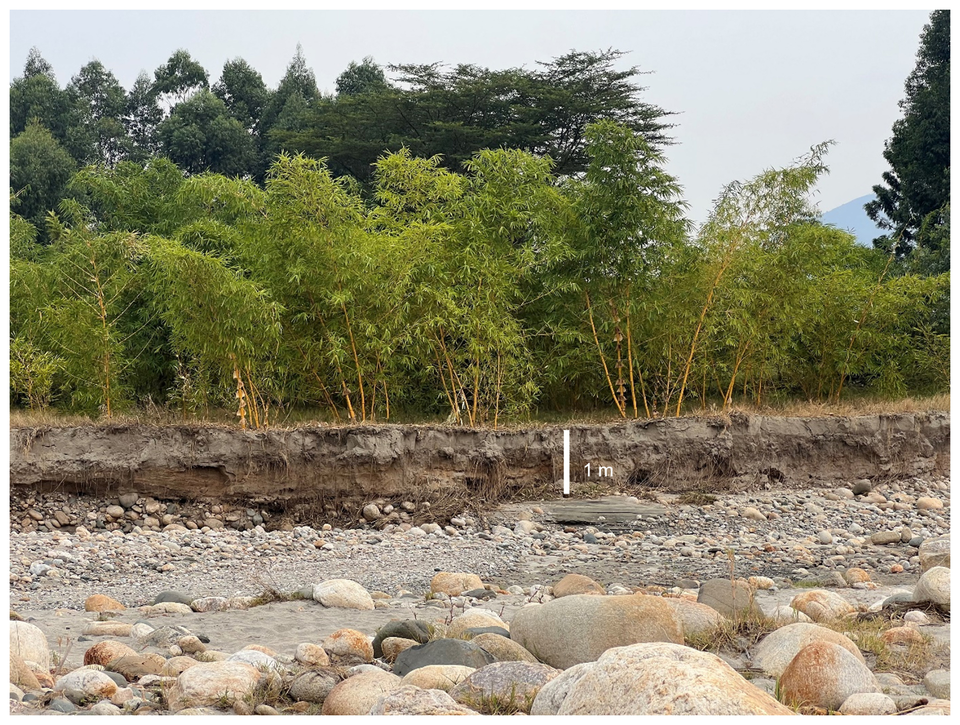
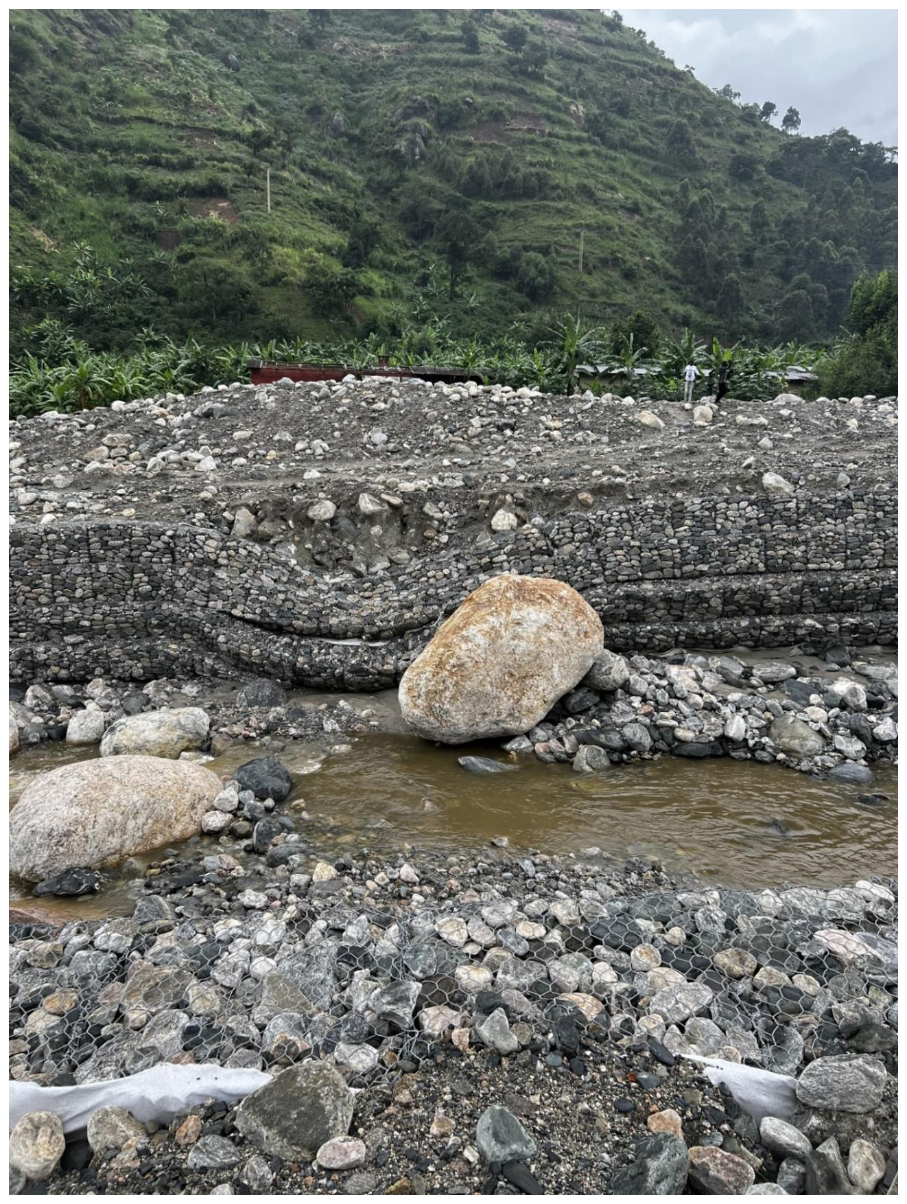
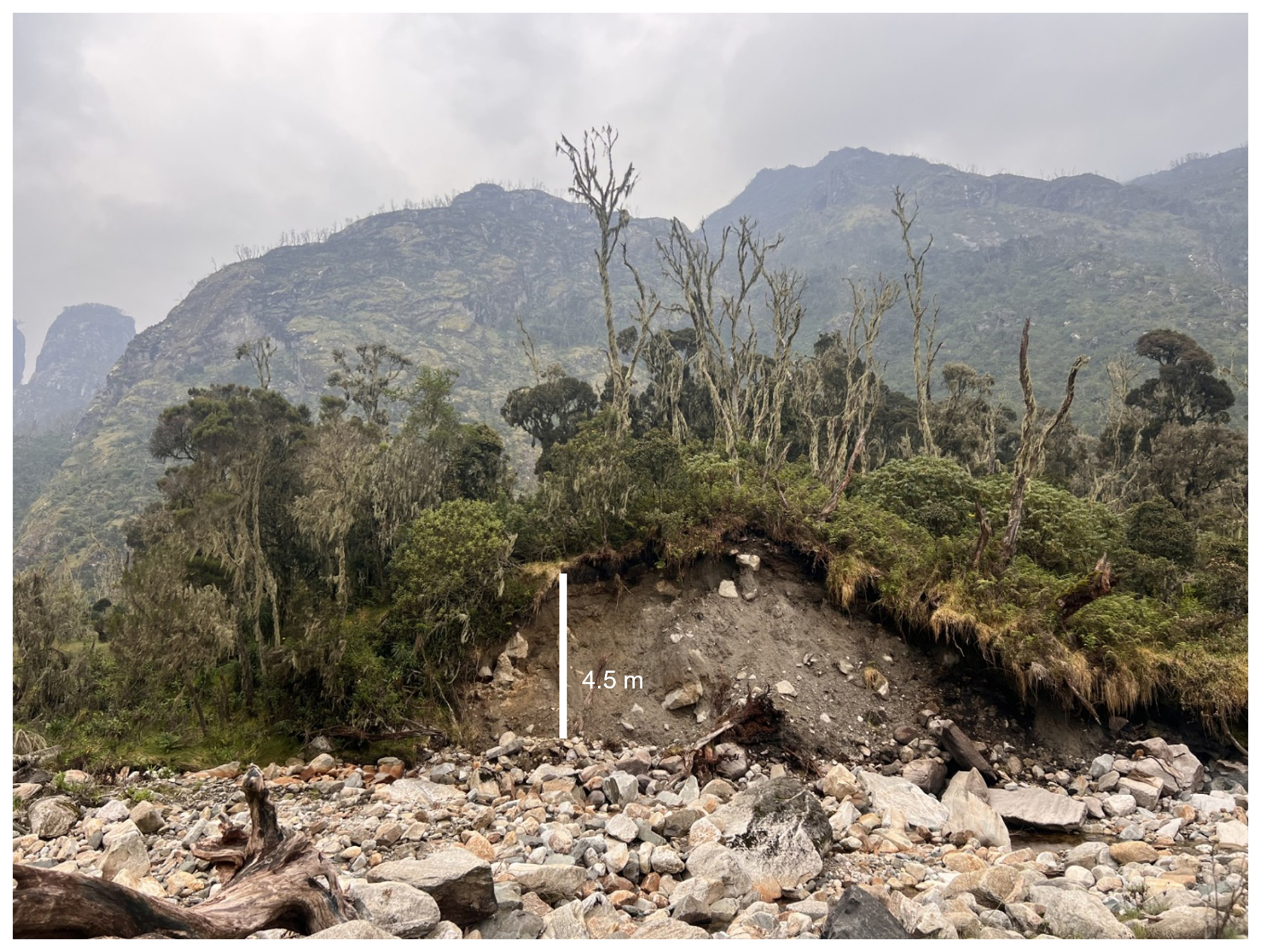
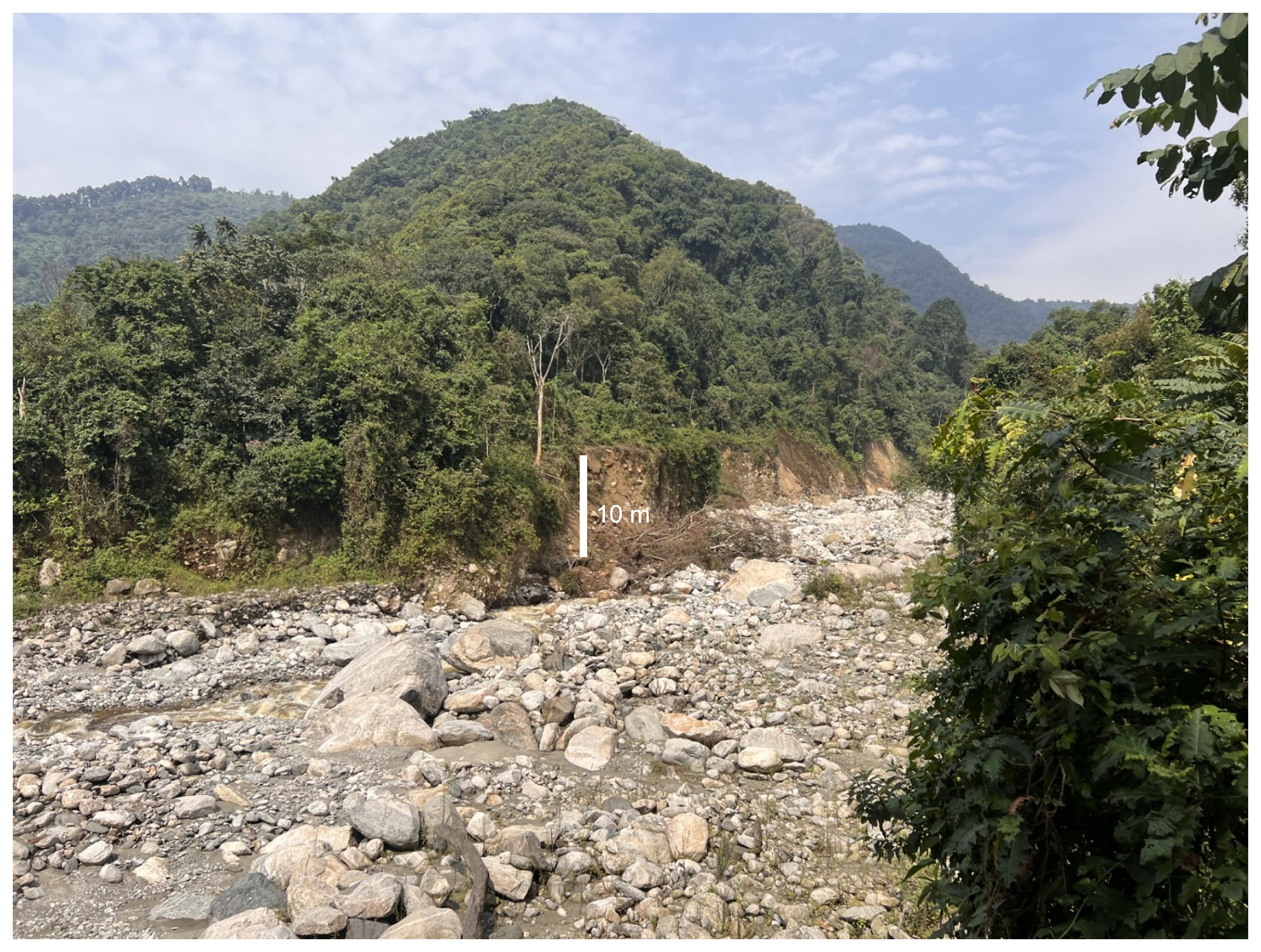
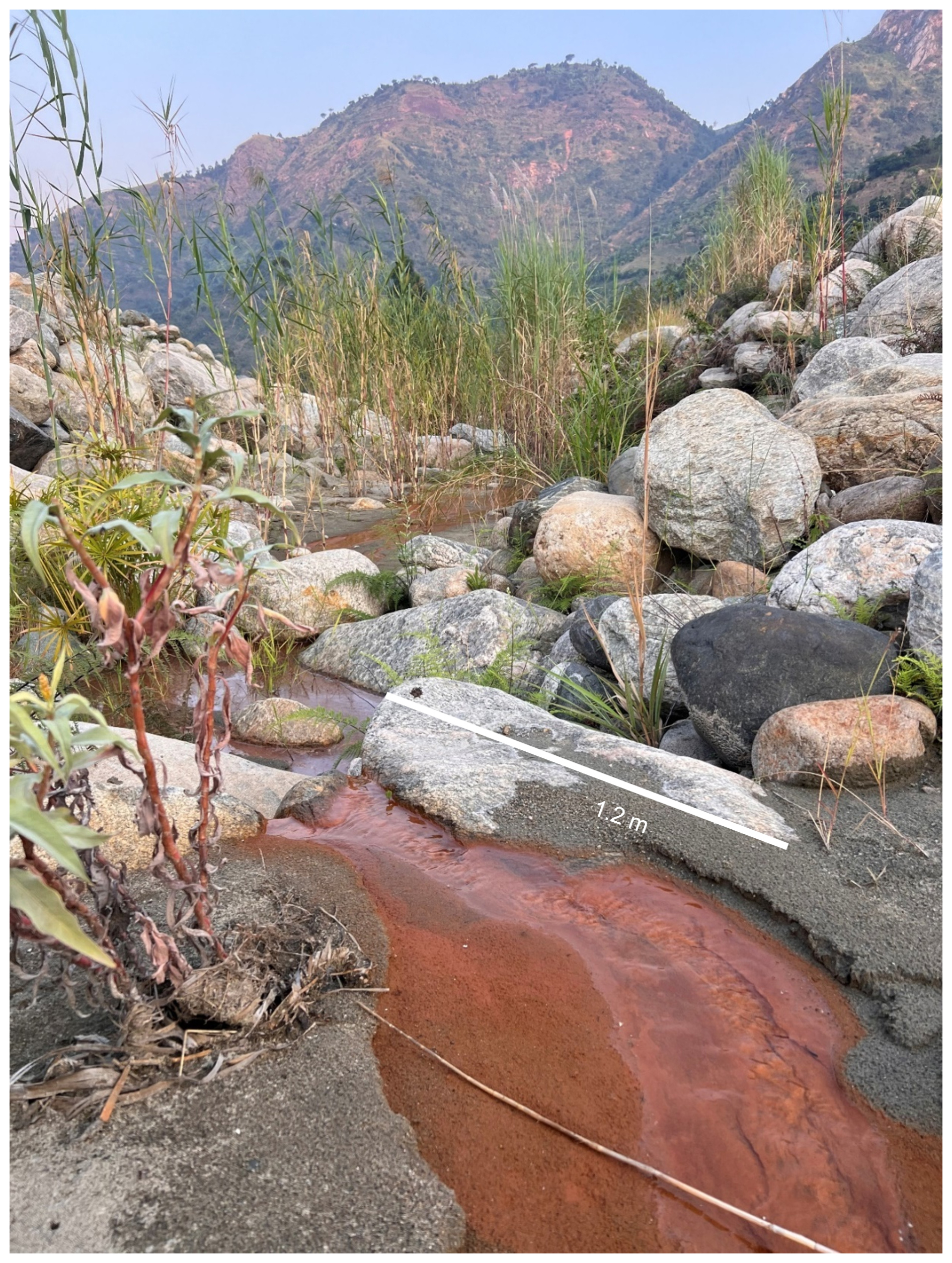
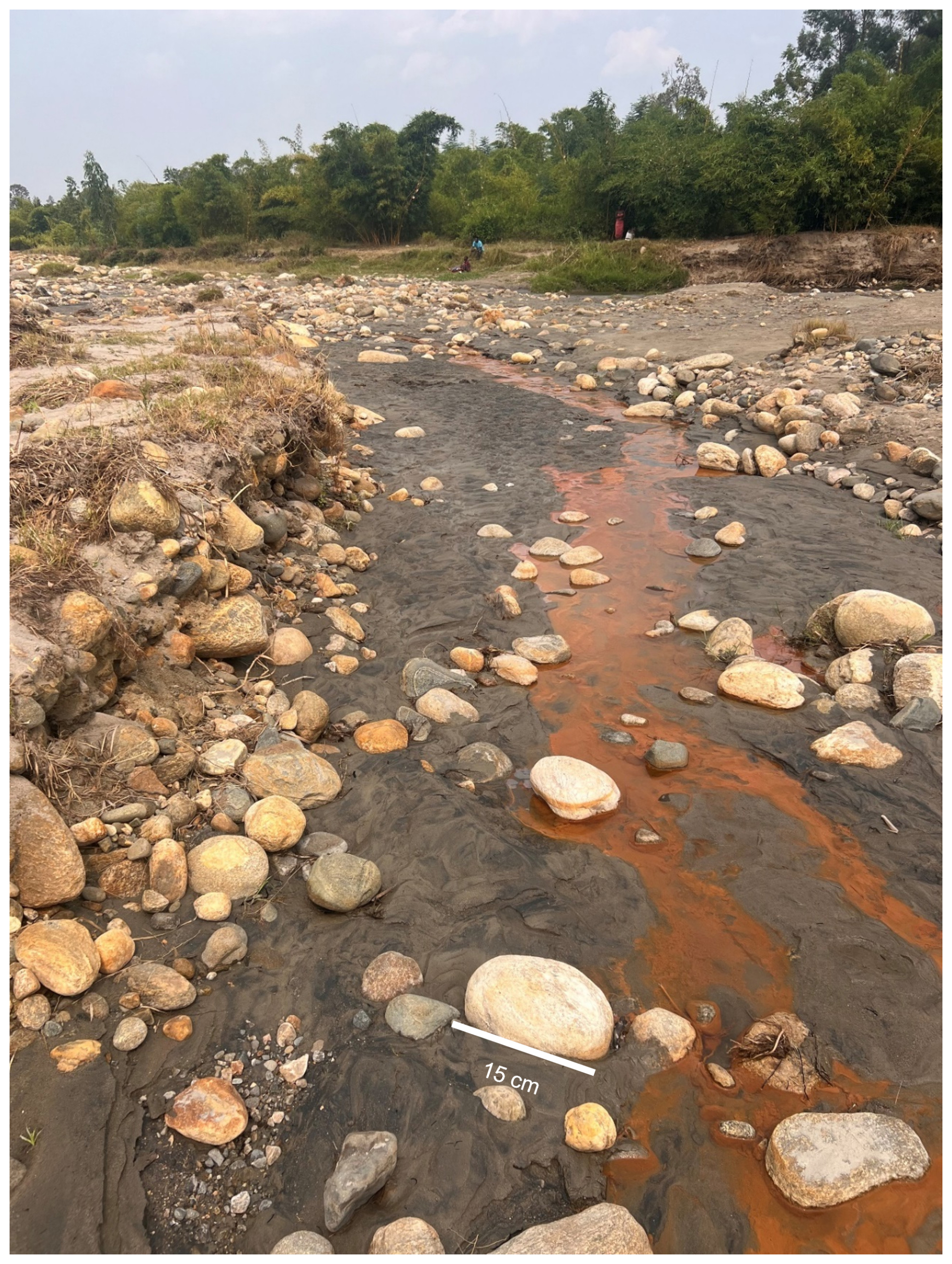
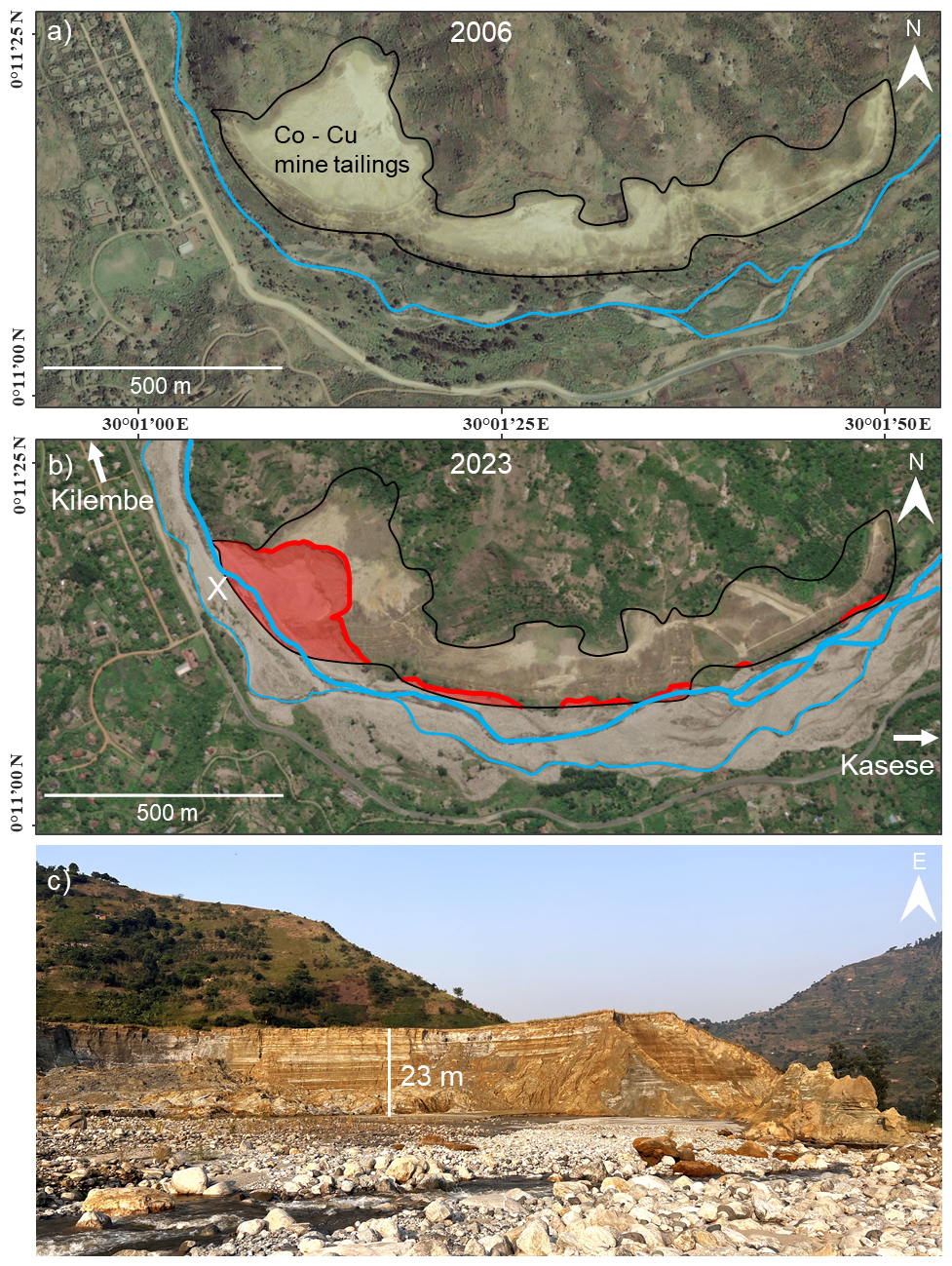
Figure K1(a) Kilembe Mines tailings on 24 March 2006 (Maxar Technologies, 2024a); (b) the same location on 10 Apr 2023 (Maxar Technologies, 2024b) where an estimated 744 000 t of solid waste have eroded into the river. The black polygon outlines the original surface area of mine tailings, and the red polygon shows the area partly or fully eroded; (c) photograph of a section of the eroded tailings taken in July 2024 at position X (b), facing east towards Kasese town.
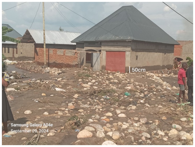
Figure L1Photograph following flooding in Kasese town evidencing the inundation level and post-flood ground contamination. Photograph provided by the Ministry of Water and Environment.
The disaster risk management (DRM) strategies in Table L1 have been implemented in the Nyamwamba catchment since the May 2013 floods. Whilst relocation of communities experiencing near-annual flooding is considered desirable for mitigating their flood risk [M1, M2, N1], residents have opposed relocation due to existing community and land ties, lower living costs on flood plain and a lack of economic opportunity in areas proposed for relocation [M1, G2, N1]. Instead, therefore, strategies have focussed on protecting existing communities and informal settlements on the flood plain with hard engineering, community-centred and nature-based solutions (Table L1).
For hard engineering strategies, respondents believe that gabions are too weak to sustainably channelise the river [R1, M2] (Fig. M1a), whereas there is demand for the successful concrete channelisation to be extended beyond Kilembe town centre [R1, R2, M2] (Fig. M1b). Channel dredging is perceived to be a critical activity, not because of successful implementations since 2013, but due to successful historic programmes of dredging by mining companies when Kilembe mines was operational in the 1960s [G1, G2, W1, R1, M2]. For all hard engineering approaches, there is concern of an unsustainably high cost of maintenance, given the elevated rate of discharge, erosion and sediment generation in the Nyamwamba river [M1, M2].
Flood early warning systems piloted in Kilembe and Kasese using 2 local rain gauges and water level sensors have faced challenges of continuous automated data collection in hard-to-reach upstream locations, however, sharing of information between authorities and community representatives via Whatsapp has successfully coordinated evacuations following high flows and rapid dispatches of emergency respondents [N1]. A 2023 installation of a camera 5 km upstream of Kilembe, capable of international photo and video transmission at 1 min intervals (Fig. M1c), is considered a useful supplementary dataset for a more detailed interpretation by those with lived experience and indigenous knowledge of the river [N1, M2]. For rivers with a debris-flow model of flooding, setting qualitative thresholds of perceived flood severity from imagery may have more local predictive value than water levels in channels where channel location and roughness change frequently [M2].
A project funded by the World Bank and implemented by the Ugandan Ministry of Water and Environment (MoWE) in 2021–2022 has installed a range of nature-based (NbS) and community-centred solutions (World Bank, 2022). The NbS of riverbank stabilisation in Kasese is considered especially promising [R1, R3, W1, M1, M2], using 35 000 asper bamboo seedlings and other economic crops in buffer zones on the mid-catchment riverbanks to prevent erosion. Despite challenges with drought, flooding, termites and metal-contaminated soils during the early implementation [W1, M2, G2], a previous project successfully stabilising the Mubuku riverbanks for 20 years [M1] and observations of stable bamboo forests in the upper catchment [R1] provide optimism for the project. Respondents are more critical of other parts of the project, including soil-water conservation and participatory desilting of the river (Table L1), for focussing on the mid-catchment around Kasese town, when discharge and sediment generation is taking place higher in the mountains [R1, I2].
“the assumptions made are well off beat; 99 % of the water is coming from the park” – R1
Notably, there have been no DRR interventions so far in the wildfire affected area of the upper catchment, and no active mitigation of mine tailing erosion into the river Nyamwamba. In both cases, a low awareness of their impacts has inhibited action [M2, R1, W1, G2]. 7 of 12 interview respondents did not mention the 2012 wildfire when asked to describe factors affecting local flood risk, and only one small-scale academic study has assessed water quality in the Nyamwamba since large-scale erosion began in 2015 (Mukisa et al., 2020). Of the respondents aware of the wildfire [R1, W1, M1, M2, G2] and water quality problems [M1, M2, G1, G2] in the Nyamwamba catchment, all recommend restoration of the wildfire-affected area and urgent mitigation of further erosion into the river.
Table M1Summary of disaster risk reduction strategies in Kasese Districts observed during field reconnaissance and described by interview respondents.
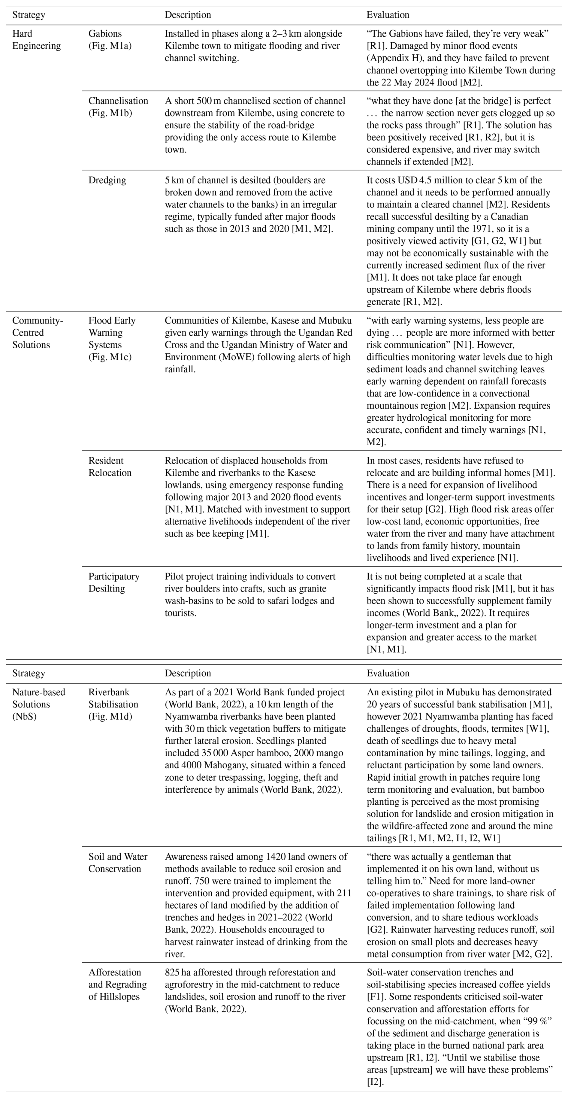
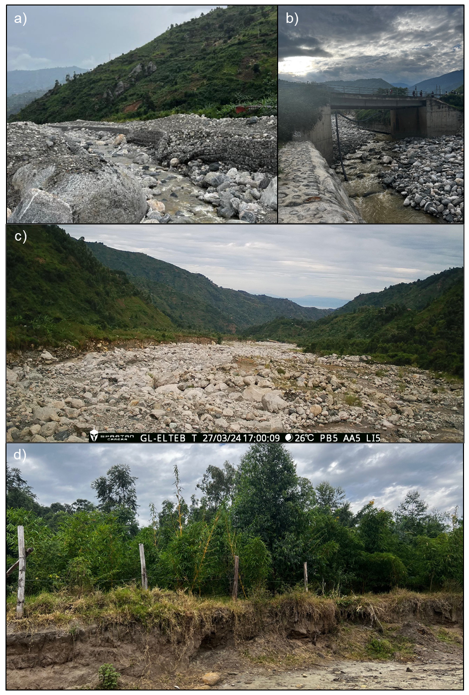
Figure M1Photographs taken during June 2023 field reconnaissance: (a) collapsed gabions adjacent to Kilembe town (for scale: 8 m channel width); (b) channelisation using concrete embankments in Kilembe town centre (10 m channel width under bridge); (c) photo from a camera transmitting photos at 1 min intervals 5 km upstream of Kilembe town centre for flood early warning; (d) riverbank stabilisation adjacent to Kasese town including asper bamboo (4 m fencepost spacing).
The interview data is confidential according to ethical and data sharing restrictions. The GIS data files are available in Zenodo (https://doi.org/10.5281/zenodo.20556393, Veness et al., 2026).
William Veness (co-lead): Writing – review & editing, Supervision, Writing – original draft, Visualization, Validation, Software, Resources, Project administration, Methodology, Investigation, Funding acquisition, Formal analysis, Data curation, Conceptualization
Martha Day (co-lead): Writing – review & editing, Writing – original draft, Visualization, Validation, Software, Resources, Project administration, Methodology, Investigation, Funding acquisition, Formal analysis, Data curation, Conceptualization
Anthony C. Ross: Writing – review & editing, Investigation, Data Curation, Validation
Yazidhi Bamutaze: Writing – review & editing, Funding acquisition, Data curation, Supervision, Investigation, Validation, Conceptualization.
Jiayuan Han: Methodology, Investigation, Data Curation, Visualiazation, Software
Douglas Mulangwa: Project administration, Resources, Data curation, Investigation
Anthony Mwesigwa: Writing – review & editing, Project administration, Data curation, Investigation
Emmanuel Ntale: Project administration, Resources, Investigation
Callist Tindimugaya: Project administration, Resources, Methodology, Supervision, Conceptualization
Brian Guma: Project administration, Resources, Methodology, Investigation, Conceptualization, Supervision, Validation
Elisabeth Stephens: Writing – review & editing, Investigation, Project administration, Resources, Data Curation, Investigation, Validation
Wouter Buytaert: Writing – review & editing, Supervision, Methodology, Investigation, Project administration, Conceptualization, Validation.
The contact author has declared that none of the authors has any competing interests.
Publisher's note: Copernicus Publications remains neutral with regard to jurisdictional claims made in the text, published maps, institutional affiliations, or any other geographical representation in this paper. The authors bear the ultimate responsibility for providing appropriate place names. Views expressed in the text are those of the authors and do not necessarily reflect the views of the publisher.
We thank the Uganda Red Cross Society, the Ministry of Water and Environment, Kasese Municipality, and all local collaborators and community members in Kasese District for their contributions to this research. We are grateful to the Uganda Wildlife Authority and Rwenzori Trekking Services for facilitating access to the Rwenzori Mountains National Park. The Red Cross Red Crescent Climate Centre is also gratefully acknowledged for its role in establishing the partnership with the Uganda Red Cross and the Ministry of Water and Environment.
This research was initiated following work undertaken through the SHEAR programme, supported by the Natural Environment Research Council (grant no. NE/P000452/1). The study was funded with support from Imperial College London's African Research Universities Alliance (ARUA) partnership, which enabled collaboration with Makerere University. Martha Day's contribution was funded through her UKRI NERC-funded doctoral training programme (grant no. NE/S007415/1).
This paper was edited by Mihai Niculita and reviewed by three anonymous referees.
Abraham, M. R. and Susan, T. B.: Water contamination with heavy metals and trace elements from Kilembe copper mine and tailing sites in Western Uganda; implications for domestic water quality, Chemosphere, 169, 281–287, https://doi.org/10.1016/j.chemosphere.2016.11.077, 2017.
Act Alliance: ACT Alliance Preliminary Appeal UGA131: Flash Floods in Kasese, Uganda, https://reliefweb.int/report/uganda/act-alliance-preliminary-appeal-uga131-flash-floods-kasese-uganda (last access: 14 October 2025), 2013.
Act Alliance: Uganda: Flood Emergency, RRF No. 04/2020, https://actalliance.org/wp-content/uploads/2020/06/Uganda_Floods-Emergency-RRF-No.-04.pdf (last access: 29 June 2026), 2020.
AghaKouchak, A., Huning, L. S., Chiang, F., Sadegh, M., Vahedifard, F., Mazdiyasni, O., Moftakhari, H., and Mallakpour, I.: How do natural hazards cascade to cause disasters?, Nature, 561, 458–460, https://doi.org/10.1038/d41586-018-06783-6, 2018.
AghaKouchak, A., Chiang, F., Huning, L. S., Love, C. A., Mallakpour, I., Mazdiyasni, O., Moftakhari, H., Papalexiou, S. M., Ragno, E., and Sadegh, M.: Climate extremes and compound hazards in a warming world, Annu. Rev. Earth Pl. Sc., 48, 519–548, https://doi.org/10.1146/annurev-earth-071719-055228, 2020.
Ahmad, Z. U., Sakib, S., and Gang, D. D.: Nonpoint source pollution, Water Environ. Res., 88, 1594–1619, https://doi.org/10.2175/106143016X14696400495497, 2016.
Arango-Carmona, M. I., Voit, P., Hürlimann, M., Aristizábal, E., and Korup, O.: Hillslope torrential hazard cascades in tropical mountains, Nat. Hazards Earth Syst. Sci., 25, 3641–3663, https://doi.org/10.5194/nhess-25-3641-2025, 2025.
Asiimwe, W.: Kasese hit fresh floods, New Vision, https://newvision.co.ug/news/1341922/kasese-hit-fresh-floods (last access: 14 October 2025), 2014.
Belongia, M. F., Hammond Wagner, C., Seipp, K. Q., and Ajami, N. K.: Building water resilience in the face of cascading wildfire risks, Sci. Adv., 9, eadf9534, https://doi.org/10.1126/sciadv.adf9534, 2023.
Bombino, G., D'Agostino, D., Marziliano, P. A., Pérez Cutillas, P., Praticò, S., Proto, A. R., Manti, L. M., Lofaro, G., and Zimbone, S. M.: A nature-based approach using felled burnt logs to enhance forest recovery post-fire and reduce erosion phenomena in the Mediterranean area, Land, 13, 236, https://doi.org/10.3390/land13020236, 2024.
Boyer, E. W., Wagenbrenner, J. W., and Zhang, L.: Wildfire and hydrological processes, Hydrol. Process., 36, e14640, https://doi.org/10.1002/hyp.14640, 2022.
Church, M. and Jakob, M.: What is a debris flood?, Water Resour. Res., 56, e2020WR027144, https://doi.org/10.1029/2020WR027144, 2020.
Coalition for the Poudre River Watershed (CPRW): Low-Tech Process-Based Restoration, https://www.poudrewatershed.org/ltpbr, last access: 12 April 2026.
Coconino County Flood Control District: Alluvial Fan Stabilization Project, Coconino County, Arizona, https://www.coconino.az.gov/2407/Alluvial-Fan-Stabilization-Project, last access: 12 April 2026.
Congedo, L.: Semi-Automatic Classification Plugin: a Python tool for the download and processing of remote sensing images in QGIS, J. Open Source Softw., 6, 3172, https://doi.org/10.21105/joss.03172, 2021.
Copernicus Climate Change Service (C3S): ERA5: fifth generation of ECMWF atmospheric reanalyses of the global climate, Copernicus Climate Change Service Climate Data Store (CDS), https://doi.org/10.24381/cds.adbb2d47, 2017.
Costa, J. E. and Schuster, R. L.: The formation and failure of natural dams, Open-File Report 87-392, U.S. Geological Survey, Vancouver, Washington, https://pubs.usgs.gov/of/1987/0392/report.pdf (last access: 24 April 2026), 1987.
Creswell, J. W.: Research Design: Qualitative, Quantitative and Mixed Methods Approaches, 3rd edn., SAGE Publications, https://www.ucg.ac.me/skladiste/blog_609332/objava_105202/fajlovi/Creswell.pdf (last access: 14 October 2025), 2009.
Cruden, D. M. and Varnes, D. J.: Landslide types and processes, in: Landslides: Investigation and Mitigation, Transportation Research Board Special Report 247, U.S. National Academy of Sciences, Washington, D.C., 36–75, ISBN 978-0-309-06151-3, https://onlinepubs.trb.org/Onlinepubs/sr/sr247/sr247-003.pdf (last access: 29 June 2026), 1996.
DeBano, L. F.: The role of fire and soil heating on water repellency in wildland environments: a review, J. Hydrol., 231–232, 195–206, https://doi.org/10.1016/S0022-1694(00)00194-3, 2000.
Delforge, D., Wathelet, V., Below, R., Lanfredi Sofia, C., Tonnelier, M., van Loenhout, J. A. F., and Speybroeck, N.: EM-DAT: the Emergency Events Database, Int. J. Disast. Risk Re., 105509, https://doi.org/10.1016/j.ijdrr.2025.105509, 2025.
DesInventar: DesInventar Database, UNDRR, https://www.desinventar.net/ (last access: 14 October 2025), 2025.
Doerr, S. H., Shakesby, R. A., and Walsh, R. P. D.: Soil water repellency: its causes, characteristics and hydro-geomorphological significance, Earth-Sci. Rev., 51, 33–65, https://doi.org/10.1016/S0012-8252(00)00011-8, 2000.
Encalada, A. C., Flecker, A. S., Poff, N. L., Suárez, E., Herrera-R, G. A., Ríos-Touma, B., Jumani, S., Larson, E. I., and Anderson, E. P.: A global perspective on tropical montane rivers, Science, 365, 1124–1129, https://doi.org/10.1126/science.aax1682, 2019.
European Environment Agency: Nature-based solutions for fire-resilient European forests, Publications Office of the European Union, Luxembourg, https://doi.org/10.2800/8810870, 2025.
FAO: Integrated fire management voluntary guidelines – principles and strategic actions, 2nd edn., Forestry Working Paper No. 41, FAO, Rome, https://doi.org/10.4060/cd1090en, 2024.
FAO and UNEP: The State of the World's Forests 2020, FAO and UNEP, Rome, https://doi.org/10.4060/ca8642en, 2020.
FAO and UNEP: Global assessment of soil pollution: report, FAO and UNEP, Rome, https://doi.org/10.4060/cb4894en, 2021.
Flood List News: Uganda – 8 dead after more floods in Kasese, Flood List, https://floodlist.com/africa/uganda-floods-kasese-may-2020 (last access: 14 October 2025), 2020a.
Flood List News: Uganda – thousands affected by floods in western region, Flood List, https://floodlist.com/africa/uganda-thousands-affected-by-floods-in-western-region (last access: 14 October 2025), 2020b.
Galletta, A.: Mastering the Semi-Structured Interview and Beyond: From Research Design to Analysis and Publication, New York University Press, New York, https://doi.org/10.18574/nyu/9780814732939.001.0001, 2020.
Gearon, J., Martin, H. K., DeLisle, C., Barefoot, E. A., Mohrig, D., Paola, C., and Edmonds, D. A.: Rules of River Avulsion Supplementary Data Files (Version 0.0.2), Zenodo [data set], https://doi.org/10.5281/zenodo.10338685, 2024.
Gill, J. C. and Malamud, B. D.: Hazard interactions and interaction networks (cascades) within multi-hazard methodologies, Earth Syst. Dynam., 7, 659–679, https://doi.org/10.5194/esd-7-659-2016, 2016.
Google News: Google News Search, https://news.google.com/home?hl=en-GB&gl=GB&ceid=GB:en (last access: 14 October 2025), 2025.
Government of British Columbia: Post wildfire natural hazard risk analysis, https://www2.gov.bc.ca/gov/content/safety/wildfire-status/recovery/wildfire-land-based-recovery/post-wildfire-natural-hazard-risk-analysis#PWFNHRA (last access: 10 April 2026), 2023.
Guerriero, L., Tufano, R., Capozzi, V., Budillon, G., Di Muro, C., Esposito, L., Forte, G., Vitale, E., and Calcaterra, D.: A postwildfire debris flood in Gragnano, southern Italy, on September 11, 2024, Landslides, 22, 1923–1936, https://doi.org/10.1007/s10346-025-02509-8, 2025.
Haring, C. P., Altmann, G. L., Suedel, B. C., and Brown, S. W.: Using Engineering With Nature (EWN) principles to manage erosion of watersheds damaged by large-scale wildfires, Integr. Environ. Asses., 17, 1194–1202, https://doi.org/10.1002/ieam.4453, 2021.
Hasanuzzaman, M., Islam, A., Bera, B., and Shit, P. K.: Quantifying the riverbank erosion and accretion rate using DSAS model study from the lower Ganga River, India, Nat. Hazards Res., 4, 550–561, https://doi.org/10.1016/j.nhres.2023.12.015, 2024.
Hinzmann, A., Mölg, T., Braun, M., Cullen, N. J., Hardy, D. R., Kaser, G., and Prinz, R.: Tropical glacier loss in East Africa: recent areal extents on Kilimanjaro, Mount Kenya, and in the Rwenzori Range from high-resolution remote sensing data, Environ. Res.-Clim., 3, 011003, https://doi.org/10.1088/2752-5295/ad1fd7, 2024.
Hungr, O., Leroueil, S., and Picarelli, L.: The Varnes classification of landslide types, an update, Landslides, 11, 167–194, https://doi.org/10.1007/s10346-013-0436-y, 2014.
Islam, A. and Guchhait, S. K.: Characterizing cross-sectional morphology and channel inefficiency of lower Bhagirathi River, India, in post-Farakka barrage condition, Nat. Hazards, 103, 3803–3836, https://doi.org/10.1007/s11069-020-04156-9, 2020.
Jacobs, L., Maes, J., Mertens, K., Sekajugo, J., Thiery, W., Van Lipzig, N., Poesen, J., Kervyn, M., and Dewitte, O.: Reconstruction of a flash flood event through a multi-hazard approach: focus on the Rwenzori Mountains, Uganda, Nat. Hazards, 84, 851–876, https://doi.org/10.1007/s11069-016-2458-y, 2016.
Jordan, P.: Post-wildfire debris flows in southern British Columbia, Canada, Int. J. Wildland Fire, 25, 322–336, https://doi.org/10.1071/WF14070, 2016.
Juma, B.: Uganda – at least 1,000 displaced after floods in Kasese and Kampala, Flood List, https://floodlist.com/africa/uganda-1000-displaced-floods-kasese-kampala (last access: 14 October 2025), 2016.
Kappelle, M., Geuze, T., Leal, M. E., and Cleef, A. M.: Successional age and forest structure in a Costa Rican upper montane Quercus forest, J. Trop. Ecol., 12, 681–698, https://doi.org/10.1017/S0266467400009871, 1996.
Kemter, M., Fischer, M., Luna, L. V., Schönfeldt, E., Vogel, J., Banerjee, A., Korup, O., and Thonicke, K.: Cascading hazards in the aftermath of Australia's 2019/2020 Black Summer wildfires, Earth's Future, 9, e2020EF001884, https://doi.org/10.1029/2020EF001884, 2021.
Key, C. H. and Benson, N. C.: Landscape Assessment (LA): sampling and analysis methods, in: FIREMON: Fire Effects Monitoring and Inventory System, edited by: Lutes, D. C., Keane, R. E., Caratti, J. F., Key, C. H., Benson, N. C., Sutherland, S., and Gangi, L. J., Gen. Tech. Rep. RMRS-GTR-164-CD, USDA Forest Service, Rocky Mountain Research Station, Fort Collins, CO, LA1–LA51, https://doi.org/10.2737/RMRS-GTR-164, 2006.
Korup, O. and Schlunegger, F.: Bedrock landsliding, river incision, and transience of geomorphic hillslope-channel coupling: evidence from inner gorges in the Swiss Alps, J. Geophys. Res.-Earth, 112, F03027, https://doi.org/10.1029/2006JF000710, 2007.
Lawler, D. M.: The measurement of river bank erosion and lateral channel change: a review, Earth Surf. Proc. Land., 18, 777–821, https://doi.org/10.1002/esp.3290180905, 1993.
Marengo, J. A., Cunha, A. P., Cuartas, L. A., Deusdará Leal, K. R., Broedel, E., Seluchi, M. E., Michelin, C. M., De Praga Baião, C. F., Chuchón Angulo, E., Almeida, E. K., Kazmierczak, M. L., Mateus, N. P. A., Silva, R. C., and Bender, F.: Extreme drought in the Brazilian Pantanal in 2019–2020: characterization, causes, and impacts, Front. Water, 3, 639204, https://doi.org/10.3389/frwa.2021.639204, 2021.
Mason, A. L., Pereboom, E. M. B., Ivory, S. J., Vachula, R. S., Kelly, M. A., Nakileza, B., and Russell, J. M.: Twenty-first century emergence of alpine fire in Central African mountains, Nature, 653, 746–751, https://doi.org/10.1038/s41586-026-10511-w, 2026.
Maxar Technologies: Historical satellite imagery from March 2006 of Kilembe, Uganda, Google Earth Pro, https://www.google.com/earth/about/versions/#earth-pro (last access: 14 October 2025), 2025a.
Maxar Technologies: Satellite imagery from 10 April 2023 of Kilembe, Uganda, Bing Maps, https://www.bing.com/maps (last access: 14 October 2025), 2025b.
McCaffrey, S.: Thinking of wildfire as a natural hazard, Soc. Nat. Resour., 17, 509–516, https://doi.org/10.1080/08941920490452445, 2004.
McGuire, L. A., Ebel, B. A., Rengers, F. K., Vieira, D. C. S., and Nyman, P.: Fire effects on geomorphic processes, Nat. Rev. Earth Environ., 5, 486–503, https://doi.org/10.1038/s43017-024-00557-7, 2024.
McKee, T. B., Doesken, N. J., and Kleist, J.: The relationship of drought frequency and duration to time scales, in: Proceedings of the 8th Conference on Applied Climatology, Anaheim, California, 17–22 January 1993, 179–184, https://climate.colostate.edu/pdfs/relationshipofdroughtfrequency.pdf (last access: 29 June 2026), 1993.
Mojtahed, R., Nunes, M. B., Martins, J. T., and Peng, A.: Equipping the constructivist researcher: the combined use of semi-structured interviews and decision-making maps, Electron. J. Bus. Res. Methods, 12, 87–95, 2014.
Moody, J. A. and Martin, D. A.: Initial hydrologic and geomorphic response following a wildfire in the Colorado Front Range, Earth Surf. Proc. Land., 26, 1049–1070, https://doi.org/10.1002/esp.253, 2001.
World Bank: Integrated Water Management and Development Project (P163782): Implementation Status & Results Report, Report No. ISR53182, World Bank, Washington, D.C., https://documents1.worldbank.org/curated/en/099540010172230683/pdf/P1637820a5f3b50620b7730e052a4841570.pdf, last access: 17 October 2022.
Mukisa, W., Yatuha, J., Andama, M., and Kasangaki, A.: Heavy metal pollution in the main rivers of Rwenzori Region, Kasese District, South-Western Uganda, Oct. Jour. Env. Res., 8, 78–90, 2020.
Mwesigye, A. R. and Lawrence, O. B.: Trace elements contamination of Kilembe copper mine catchment soils in Kasese District, Western Uganda, Soil Sediment Contam., 33, 232–243, https://doi.org/10.1080/15320383.2023.2195512, 2024.
Mwesigye, A. R., Young, S. D., Bailey, E. H., and Tumwebaze, S. B.: Population exposure to trace elements in the Kilembe copper mine area, Western Uganda: a pilot study, Sci. Total Environ., 573, 366–375, https://doi.org/10.1016/j.scitotenv.2016.08.125, 2016.
Mwongyera, A., Mbabazi, J., Muwanga, A., Ntale, M., and Kwetegyeka, J.: Impact of the disused Kilembe mine pyrites on the domestic water quality of Kasese town, western Uganda, Caribb. J. Sci. Technol., 2, 482–495, 2014.
NASA Shuttle Radar Topography Mission: SRTM GL1 Global 30m, OpenTopography [data set], https://doi.org/10.5069/G9445JDF, 2013.
National Interagency Fire Center (NIFC): Post Fire Recovery, https://www.nifc.gov/programs/post-fire-recovery (last access: 10 April 2026), 2026.
New Vision: Kasese PWDs bear the brunt of floods, landslides, https://web.archive.org/web/20251124071306/https://www.newvision.co.ug/category/news/kasese-pwds-bear-the-brunt-of-floods-landslid-NV_188969 (last access: 14 October 2025), 2024.
Nichter, K. A., Gilmore, T., Carbone, C., Sellers, B., Fairchild, M. P., and Preston, D. L.: Ecological characteristics of stream reaches with and without low-tech process-based restoration in a wildfire-affected catchment, River Res. Appl., https://doi.org/10.1002/rra.70119, 2026.
Norville, C., Ivory, S., Russell, J. M., Mason, A., Nakileza, B., and Miller, J.: Using charcoal to calibrate the frequency of wildfire in the Rwenzori Mountains over the Holocene, AGU Fall Meeting 2024, Washington, D.C., USA, 9–13 December 2024, https://ui.adsabs.harvard.edu/abs/2024AGUFMPP21E0525N/abstract (last access: 29 June 2026), 2024.
Oakley, N. S., Cheung, D. J., Lindsay, D. N., and Nash, D.: Insights from a 25-year database of post-fire debris flows in California, Int. J. Wildland Fire, 34, WF25136, https://doi.org/10.1071/WF25136, 2025.
Obando-Cabrera, L., Díaz-Timoté, J. J., Bastarrika, A., Celis, N., and Hantson, S.: The Paramo Fire Atlas: quantifying burned area and trends across the Tropical Andes, Environ. Res. Lett., 20, 054019, https://doi.org/10.1088/1748-9326/adc8ba, 2025.
Okiror, S.: “People are desperate”: floods and rock slides devastate western Uganda, The Guardian, https://www.theguardian.com/global-development/2020/may/16/people-are-desperate-floods-and-rock-slides-devastate-western-uganda (last access: 14 October 2025), 2020.
Oliveras, I., Malhi, Y., Salinas, N., Huaman, V., Urquiaga-Flores, E., Kala-Mamani, J., Quintano-Loaiza, J. A., Cuba-Torres, I., Lizarraga-Morales, N., and Román-Cuesta, R.-M.: Changes in forest structure and composition after fire in tropical montane cloud forests near the Andean treeline, Plant Ecol. Divers., 7, 329–340, https://doi.org/10.1080/17550874.2013.816800, 2014.
Ometto, J. P., Kalaba, K., Anshari, G. Z., Chacon, N., Farrell, A., Halim, S. A., Neufeldt, H., and Sukumar, R.: Cross-Chapter Paper 7: Tropical Forests, in: Climate Change 2022 – Impacts, Adaptation and Vulnerability: Working Group II Contribution to the Sixth Assessment Report of the Intergovernmental Panel on Climate Change, edited by: Pörtner, H.-O., Roberts, D. C., Tignor, M. M. B., Poloczanska, E. S., Mintenbeck, K., Alegría, A., Craig, M., Langsdorf, S., Löschke, S., Möller, V., Okem, A., and Rama, B., Cambridge University Press, Cambridge, UK and New York, NY, USA, https://doi.org/10.1017/9781009325844.028, 2022.
Papaioannou, G., Alamanos, A., and Maris, F.: Evaluating post-fire erosion and flood protection techniques: a narrative review of applications, GeoHazards, 4, 380–405, https://doi.org/10.3390/geohazards4040022, 2023.
Paton, D.: Disaster preparedness: a social-cognitive perspective, Disaster Prev. Manag., 12, 210–216, https://doi.org/10.1108/09653560310480686, 2003.
Patton, M. Q.: Qualitative Research & Evaluation Methods: Integrating Theory and Practice, 4th edn., SAGE Publications, Thousand Oaks, CA, ISBN 978-1-4129-7212-3, 2015.
Pierson, T. C.: Hyperconcentrated flow – transitional process between water flow and debris flow, in: Debris-flow Hazards and Related Phenomena, edited by: Jakob, M. and Hungr, O., Springer, Heidelberg, Germany, 159–202, https://doi.org/10.1007/3-540-27129-5_8, 2005.
Pivello, V. R., Vieira, I., Christianini, A. V., Ribeiro, D. B., Da Silva Menezes, L., Berlinck, C. N., Melo, F. P. L., Marengo, J. A., Tornquist, C. G., Tomas, W. M., and Overbeck, G. E.: Understanding Brazil's catastrophic fires: causes, consequences and policy needed to prevent future tragedies, Perspect. Ecol. Conserv., 19, 233–255, https://doi.org/10.1016/j.pecon.2021.06.005, 2021.
ReliefWeb: Uganda – floods (DG ECHO Partners, Uganda Red Cross, media) (ECHO Daily Flash of 10 September 2024), https://reliefweb.int/report/uganda/uganda-floods-dg-echo-partners-uganda-red-cross-media-echo-daily-flash-10-september-2024 (last access: 14 October 2025), 2024.
Rengers, F. K., McGuire, L. A., Oakley, N. S., Kean, J. W., Staley, D. M., and Tang, H.: Landslides after wildfire: initiation, magnitude, and mobility, Landslides, 17, 2631–2641, https://doi.org/10.1007/s10346-020-01506-3, 2020.
Ring, U.: Extreme uplift of the Rwenzori Mountains in the East African Rift, Uganda: structural framework and possible role of glaciations, Tectonics, 27, TC4018, https://doi.org/10.1029/2007TC002176, 2008.
Robichaud, P. R., Lewis, S. A., Wagenbrenner, J. W., Ashmun, L. E., and Brown, R. E.: Post-fire mulching for runoff and erosion mitigation, Catena, 105, 75–92, https://doi.org/10.1016/j.catena.2012.11.015, 2013.
Robinne, F. N., Hallema, D. W., Bladon, K. D., Flannigan, M. D., Boisramé, G., Bréthaut, C. M., Doerr, S. H., Di Baldassarre, G., Gallagher, L. A., Hohner, A. K., Khan, S. J., Kinoshita, A. M., Mordecai, R., Nunes, J. P., Nyman, P., Santín, C., Sheridan, G., Stoof, C. R., Thompson, M. P., Waddington, J. M., and Wei, Y.: Scientists' warning on extreme wildfire risks to water supply, Hydrol. Process., 35, e14086, https://doi.org/10.1002/hyp.14086, 2021.
Rudoy, A. N.: Glacier-dammed lakes and geological work of glacial superfloods in the Late Pleistocene, Southern Siberia, Altai Mountains, Quatern. Int., 87, 119–140, https://doi.org/10.1016/S1040-6182(01)00066-0, 2002.
Saldaña, J.: The Coding Manual for Qualitative Researchers, SAGE Publications, London, ISBN 978-1-5297-3175-0, 2021.
Salinas, N., Cosio, E. G., Silman, M., Meir, P., Nottingham, A. T., Roman-Cuesta, R. M., and Malhi, Y.: Editorial: Tropical montane forests in a changing environment, Front. Plant Sci., 12, 712748, https://doi.org/10.3389/fpls.2021.712748, 2021.
Sanches Fernandes, L. F., Sampaio Pinto, A. A., Salgado Terêncio, D. P., Leal Pacheco, F. A., and Vitor Cortes, R. M.: Combination of ecological engineering procedures applied to morphological stabilization of estuarine banks after dredging, Water, 12, 391, https://doi.org/10.3390/w12020391, 2020.
Sandwell, D., Anderson, D. L., and Wessel, P.: Global tectonic maps, in: Plates, Plumes and Paradigms, edited by: Foulger, G. R., Natland, J. H., Presnall, D. C., and Anderson, D. L., Geological Society of America, https://doi.org/10.1130/0-8137-2388-4.1, 2005.
Saunders, M., Lewis, P., and Thornhill, A.: Research Methods for Business Students, 7th edn., Pearson, Harlow, UK, ISBN 978-1-292-01662-7, 2016.
Schenk, E. R., Wood, A., Haden, A., Baca, G., Fleishman, J., and Loverich, J.: Post-wildfire sediment source and transport modeling, empirical observations, and applied mitigation: an Arizona, USA, case study, Nat. Hazards Earth Syst. Sci., 25, 727–745, https://doi.org/10.5194/nhess-25-727-2025, 2025.
Scheper, A. C., Verweij, P. A., and Van Kuijk, M.: Post-fire forest restoration in the humid tropics: a synthesis of available strategies and knowledge gaps for effective restoration, Sci. Total Environ., 771, 144647, https://doi.org/10.1016/j.scitotenv.2020.144647, 2021.
Shakesby, R. A. and Doerr, S. H.: Wildfire as a hydrological and geomorphological agent, Earth-Sci. Rev., 74, 269–307, https://doi.org/10.1016/j.earscirev.2005.10.006, 2006.
Sklar, L. S. and Dietrich, W. E.: Sediment and rock strength controls on river incision into bedrock, Geology, 29, 1087–1090, https://doi.org/10.1130/0091-7613(2001)029<1087:SARSCO>2.0.CO;2, 2001.
Slingerland, R. and Smith, N. D.: River avulsions and their deposits, Annu. Rev. Earth Pl. Sc., 32, 257–285, https://doi.org/10.1146/annurev.earth.32.101802.120201, 2004.
Stock, J. and Dietrich, W. E.: Valley incision by debris flows: evidence of a topographic signature, Water Resour. Res., 39, 1089, https://doi.org/10.1029/2001WR001057, 2003.
Stoof, C. R., Vervoort, R. W., Iwema, J., van den Elsen, E., Ferreira, A. J. D., and Ritsema, C. J.: Hydrological response of a small catchment burned by experimental fire, Hydrol. Earth Syst. Sci., 16, 267–285, https://doi.org/10.5194/hess-16-267-2012, 2012.
Swain, D. L., Prein, A. F., Abatzoglou, J. T., Albano, C. M., Brunner, M., Diffenbaugh, N. S., Singh, D., Skinner, C. B., and Touma, D.: Hydroclimate volatility on a warming Earth, Nat. Rev. Earth Environ., 6, 35–50, https://doi.org/10.1038/s43017-024-00624-z, 2025.
UNdata: UNdata Glossary: nonpoint source pollution, https://data.un.org/Glossary.aspx?q=nonpoint+source+pollution (last access: 24 April 2026), 2026.
UNDRR: Hazard Information Profiles, United Nations Office for Disaster Risk Reduction, https://www.preventionweb.net/drr-glossary/hips (last access: 12 April 2026), 2025.
UNEP: Spreading like wildfire – the rising threat of extraordinary landscape fires, A UNEP Rapid Response Assessment, United Nations Environment Programme, Nairobi, https://wedocs.unep.org/handle/20.500.11822/38372 (last access: 29 June 2026), 2022.
UNESCO: State of conservation of World Heritage properties inscribed on the World Heritage List, WHC-12/36.COM/7B, United Nations Educational, Scientific and Cultural Organization, Paris, https://whc.unesco.org/archive/2012/whc12-36com-7B-en.pdf (last access: 12 April 2026), 2012.
UNESCO and WMO (Eds.): International Glossary of Hydrology, WMO, Geneva, ISBN 978-92-63-03385-8, https://unesdoc.unesco.org/ark:/48223/pf0000221862 (last access: 29 June 2026), 2012.
Vahedifard, F., Abdollahi, M., Leshchinsky, B. A., Stark, T. D., Sadegh, M., and AghaKouchak, A.: Interdependencies between wildfire-induced alterations in soil properties, near-surface processes, and geohazards, Earth Space Sci., 11, e2023EA003498, https://doi.org/10.1029/2023EA003498, 2024.
Veness, W. A. and Buytaert, W.: Towards an evidence base for groundwater data investments, Environ. Sci. Policy, 164, 104014, https://doi.org/10.1016/j.envsci.2025.104014, 2025.
Veness, W., Day, M., Ross, A. C., Bamutaze, Y., Han, J., Mulangwa, D., Mwesigwa, A., Ntale, E., Tindimugaya, C., Guma, B. B., Stephens, S., and Buytaert, W.: Data Set for Study – The long-term hazard cascade of an unprecedented wildfire in a tropical mountain ecosystem, Zenodo [data set], https://doi.org/10.5281/zenodo.20556393, 2026.
Wesche, K., Miehe, G., and Kaeppeli, M.: The significance of fire for Afroalpine ericaceous vegetation, Mt. Res. Dev., 20, 340–347, https://doi.org/10.1659/0276-4741(2000)020[0340:TSOFFA]2.0.CO;2, 2000.
Wheaton, J. M., Bennett, S. N., Bouwes, N., Maestas, J. D., and Shahverdian, S.: Low-Tech Process-Based Restoration of Riverscapes: Design Manual, Version 1.0, Utah State University Restoration Consortium, Logan, UT, https://doi.org/10.13140/RG.2.2.19590.63049/2, 2019.
Williams, D. J.: Placing soil covers on soft mine tailings, in: Ground Improvement Case Histories, Elsevier, 51–81, https://doi.org/10.1016/B978-0-08-100698-6.00002-7, 2015.
Wimberly, M. C., Wanyama, D., Doughty, R., Peiro, H., and Crowell, S.: Increasing fire activity in African tropical forests is associated with deforestation and climate change, Geophys. Res. Lett., 51, e2023GL106240, https://doi.org/10.1029/2023GL106240, 2024.
Xiao, C., Feng, Z., and Li, P.: Active fires show an increasing elevation trend in the tropical highlands, Glob. Change Biol., 28, 2790–2803, https://doi.org/10.3389/ffgc.2023.1252587, 2022
- Abstract
- Introduction
- Methods
- Results
- Discussion: Implications for Management
- Conclusions
- Appendix A: 1-Month Standardised Precipitation Index Calculation for January 2012
- Appendix B: Eroded Tailings Volume Calculation
- Appendix C: Semi-Structured Interview Template
- Appendix D: The Multi-Hazard Cascade Interactions
- Appendix E: Tailings Pollution Photographs
- Appendix F: Exposed Riverbank Photographs
- Appendix G: Flood Plain Boulder Deposition Photographs
- Appendix H: Damaged Flood Defences Photographs
- Appendix I: Landslide Talus Entering the River Photographs
- Appendix J: Lower Course Deposition of Solid Mine Tailings Photographs
- Appendix K: Kilembe Mines Co-Cu Tailings Erosion
- Appendix L: Post-flood photos from September 2024 flood event
- Appendix M: Management Strategies and their Evaluation
- Data availability
- Author contributions
- Competing interests
- Disclaimer
- Acknowledgements
- Financial support
- Review statement
- References