
Articles | Volume 26, issue 11
https://doi.org/10.5194/nhess-26-5815-2026
© Author(s) 2026. This work is distributed under
the Creative Commons Attribution 4.0 License.
the Creative Commons Attribution 4.0 License.
https://doi.org/10.5194/nhess-26-5815-2026
© Author(s) 2026. This work is distributed under
the Creative Commons Attribution 4.0 License.
the Creative Commons Attribution 4.0 License.
Research article
| 
13 Nov 2026
Research article |
| 13 Nov 2026
| 13 Nov 2026
Evaluating the performance of a numerical weather prediction model for precipitation and temperature in Luxembourg and the Greater Region: insights from WRF and WRFDA 3D-VAR

Geodesy and Geospatial Engineering, Department of Engineering, Faculty of Science, Technology and Medicine, University of Luxembourg, 2 Avenue de l'Université, 4365 Esch-sur-Alzette, Luxembourg
Felicia Norma Rebecca Teferle
Geodesy and Geospatial Engineering, Department of Engineering, Faculty of Science, Technology and Medicine, University of Luxembourg, 2 Avenue de l'Université, 4365 Esch-sur-Alzette, Luxembourg
Addisu Hunegnaw
Geodesy and Geospatial Engineering, Department of Engineering, Faculty of Science, Technology and Medicine, University of Luxembourg, 2 Avenue de l'Université, 4365 Esch-sur-Alzette, Luxembourg
Rohith Muraleedharan Thundathil
Section 1.1 Space Geodetic Techniques, GFZ Helmholtz Centre for Geosciences, Telegrafenberg, 14473 Potsdam, Germany
Jens Wickert
Section 1.1 Space Geodetic Techniques, GFZ Helmholtz Centre for Geosciences, Telegrafenberg, 14473 Potsdam, Germany
Florian Zus
Section 1.1 Space Geodetic Techniques, GFZ Helmholtz Centre for Geosciences, Telegrafenberg, 14473 Potsdam, Germany
Related authors
Haseeb ur Rehman and Félicia Norma Rebecca Teferle
Geosci. Model Dev., 19, 9831–9855, https://doi.org/10.5194/gmd-19-9831-2026, https://doi.org/10.5194/gmd-19-9831-2026, 2026
Short summary
Short summary
Artificial intelligence (AI) weather models are now competing with traditional physics-based models for flood forecasting. We tested three of them and a physics-based model against observations from three flood events in Luxembourg. The AI models detected light rain and predicted temperatures better, but the physics-based model was more skilful at the heavy rainfall that actually causes floods. One AI model kept its skill on an event after its training period.
Haseeb ur Rehman and Félicia Norma Rebecca Teferle
Geosci. Model Dev., 19, 9831–9855, https://doi.org/10.5194/gmd-19-9831-2026, https://doi.org/10.5194/gmd-19-9831-2026, 2026
Short summary
Short summary
Artificial intelligence (AI) weather models are now competing with traditional physics-based models for flood forecasting. We tested three of them and a physics-based model against observations from three flood events in Luxembourg. The AI models detected light rain and predicted temperatures better, but the physics-based model was more skilful at the heavy rainfall that actually causes floods. One AI model kept its skill on an event after its training period.
Salena Akter, Félicia Teferle, and Abdul Nurunnabi
Int. Arch. Photogramm. Remote Sens. Spatial Inf. Sci., XLVIII-M-12-2026, 1–8, https://doi.org/10.5194/isprs-archives-XLVIII-M-12-2026-1-2026, https://doi.org/10.5194/isprs-archives-XLVIII-M-12-2026-1-2026, 2026
Rohith Thundathil, Florian Zus, Thomas Schwitalla, Galina Dick, and Jens Wickert
EGUsphere, https://doi.org/10.5194/egusphere-2026-4285, https://doi.org/10.5194/egusphere-2026-4285, 2026
Short summary
Short summary
GNSS zenith total delay observations measure the total amount of atmospheric water vapor, whereas GNSS tropospheric gradients provide information on how moisture varies horizontally. This study demonstrates, to our knowledge, the first assimilation of these observations for a western North Pacific typhoon, showing that they improve the representation of the storm environment and lead to more accurate simulations of Typhoon Koinu's track and intensity.
Shahoriar Parvaz, Felicia Norma Teferle, and Abdul Nurunnabi
Int. Arch. Photogramm. Remote Sens. Spatial Inf. Sci., XLVIII-1-W6-2025, 183–189, https://doi.org/10.5194/isprs-archives-XLVIII-1-W6-2025-183-2025, https://doi.org/10.5194/isprs-archives-XLVIII-1-W6-2025-183-2025, 2025
Rohith Thundathil, Florian Zus, Galina Dick, and Jens Wickert
Atmos. Meas. Tech., 18, 4907–4922, https://doi.org/10.5194/amt-18-4907-2025, https://doi.org/10.5194/amt-18-4907-2025, 2025
Short summary
Short summary
Tropospheric gradients provide information on the moisture distribution, whereas zenith total delays provide the overall moisture information along the zenith. When both observations are used together, the model can actuate the moisture fields, correcting their dynamics. Our research shows that, in regions with very few stations, assimilating tropospheric gradients on top of zenith total delay observations can enhance the performance of existing improvements.
Florian Zus, Kyriakos Balidakis, Ali Hasan Dogan, Rohith Thundathil, Galina Dick, and Jens Wickert
Geosci. Model Dev., 18, 4951–4964, https://doi.org/10.5194/gmd-18-4951-2025, https://doi.org/10.5194/gmd-18-4951-2025, 2025
Short summary
Short summary
Atmospheric signal propagation effects are one of the largest error sources in the analysis of space geodetic techniques. Inaccuracies in the modelling map into errors in positioning, navigation and timing. We describe the open-source ray-tracing tool DNS and show the two outstanding features of this tool compared to previous model developments: it can handle both the troposphere and the ionosphere, and it does so efficiently. This makes the tool perfectly suited for geoscientific applications.
Abdul Nurunnabi, Felicia Teferle, Ana Novo, Jesús Balado, and Emmett Ientilucci
Int. Arch. Photogramm. Remote Sens. Spatial Inf. Sci., XLVIII-4-W11-2024, 81–88, https://doi.org/10.5194/isprs-archives-XLVIII-4-W11-2024-81-2024, https://doi.org/10.5194/isprs-archives-XLVIII-4-W11-2024-81-2024, 2024
Abdul Nurunnabi, Felicia Teferle, Debra F. Laefer, Meida Chen, and Mir Masoom Ali
Int. Arch. Photogramm. Remote Sens. Spatial Inf. Sci., XLVIII-2-2024, 301–308, https://doi.org/10.5194/isprs-archives-XLVIII-2-2024-301-2024, https://doi.org/10.5194/isprs-archives-XLVIII-2-2024-301-2024, 2024
Shahoriar Parvaz, Felicia Teferle, and Abdul Nurunnabi
ISPRS Ann. Photogramm. Remote Sens. Spatial Inf. Sci., X-4-W4-2024, 161–168, https://doi.org/10.5194/isprs-annals-X-4-W4-2024-161-2024, https://doi.org/10.5194/isprs-annals-X-4-W4-2024-161-2024, 2024
Rohith Thundathil, Florian Zus, Galina Dick, and Jens Wickert
Geosci. Model Dev., 17, 3599–3616, https://doi.org/10.5194/gmd-17-3599-2024, https://doi.org/10.5194/gmd-17-3599-2024, 2024
Short summary
Short summary
Global Navigation Satellite Systems (GNSS) provides moisture observations through its densely distributed ground station network. In this research, we assimilate a new type of observation called tropospheric gradient observations, which has never been incorporated into a weather model. We develop a forward operator for gradient-based observations and conduct an assimilation impact study. The study shows significant improvements in the model's humidity fields.
A. Nurunnabi, Y. Sadahiro, F. N. Teferle, D. F. Laefer, and J. Li
Int. Arch. Photogramm. Remote Sens. Spatial Inf. Sci., XLVIII-1-W2-2023, 27–34, https://doi.org/10.5194/isprs-archives-XLVIII-1-W2-2023-27-2023, https://doi.org/10.5194/isprs-archives-XLVIII-1-W2-2023-27-2023, 2023
Ladina Steiner, Holger Schmithüsen, Jens Wickert, and Olaf Eisen
The Cryosphere, 17, 4903–4916, https://doi.org/10.5194/tc-17-4903-2023, https://doi.org/10.5194/tc-17-4903-2023, 2023
Short summary
Short summary
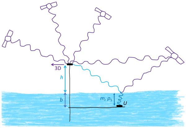
The present study illustrates the potential of a combined Global Navigation Satellite System reflectometry and refractometry (GNSS-RR) method for accurate, simultaneous, and continuous estimation of in situ snow accumulation, snow water equivalent, and snow density time series. The combined GNSS-RR method was successfully applied on a fast-moving, polar ice shelf. The combined GNSS-RR approach could be highly advantageous for a continuous quantification of ice sheet surface mass balances.
A. Nurunnabi, F. N. Teferle, D. F. Laefer, F. Remondino, I. R. Karas, and J. Li
Int. Arch. Photogramm. Remote Sens. Spatial Inf. Sci., XLVIII-4-W3-2022, 111–118, https://doi.org/10.5194/isprs-archives-XLVIII-4-W3-2022-111-2022, https://doi.org/10.5194/isprs-archives-XLVIII-4-W3-2022-111-2022, 2022
A. Nurunnabi, N. Teferle, J. Balado, M. Chen, F. Poux, and C. Sun
Int. Arch. Photogramm. Remote Sens. Spatial Inf. Sci., XLVIII-3-W2-2022, 43–50, https://doi.org/10.5194/isprs-archives-XLVIII-3-W2-2022-43-2022, https://doi.org/10.5194/isprs-archives-XLVIII-3-W2-2022-43-2022, 2022
A. Nurunnabi and F. N. Teferle
Int. Arch. Photogramm. Remote Sens. Spatial Inf. Sci., XLIII-B2-2022, 617–624, https://doi.org/10.5194/isprs-archives-XLIII-B2-2022-617-2022, https://doi.org/10.5194/isprs-archives-XLIII-B2-2022-617-2022, 2022
A. Nurunnabi, F. N. Teferle, R. C. Lindenbergh, J. Li, and S. Zlatanova
Int. Arch. Photogramm. Remote Sens. Spatial Inf. Sci., XLIII-B1-2022, 59–66, https://doi.org/10.5194/isprs-archives-XLIII-B1-2022-59-2022, https://doi.org/10.5194/isprs-archives-XLIII-B1-2022-59-2022, 2022
A. Nurunnabi, F. N. Teferle, D. F. Laefer, R. C. Lindenbergh, and A. Hunegnaw
Int. Arch. Photogramm. Remote Sens. Spatial Inf. Sci., XLVI-2-W1-2022, 401–408, https://doi.org/10.5194/isprs-archives-XLVI-2-W1-2022-401-2022, https://doi.org/10.5194/isprs-archives-XLVI-2-W1-2022-401-2022, 2022
Karina Wilgan, Galina Dick, Florian Zus, and Jens Wickert
Atmos. Meas. Tech., 15, 21–39, https://doi.org/10.5194/amt-15-21-2022, https://doi.org/10.5194/amt-15-21-2022, 2022
Short summary
Short summary
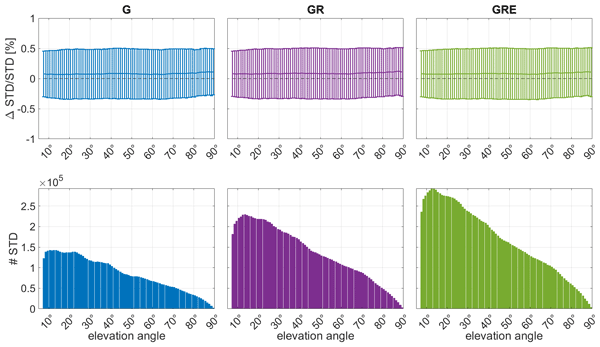
The assimilation of GNSS data in weather models has a positive impact on the forecasts. The impact is still limited due to using only the GPS zenith direction parameters. We calculate and validate more advanced tropospheric products from three satellite systems: the US American GPS, Russian GLONASS and European Galileo. The quality of all the solutions is comparable; however, combining more GNSS systems enhances the observations' geometry and improves the quality of the weather forecasts.
A. Nurunnabi, F. N. Teferle, J. Li, R. C. Lindenbergh, and S. Parvaz
Int. Arch. Photogramm. Remote Sens. Spatial Inf. Sci., XLVI-4-W5-2021, 397–404, https://doi.org/10.5194/isprs-archives-XLVI-4-W5-2021-397-2021, https://doi.org/10.5194/isprs-archives-XLVI-4-W5-2021-397-2021, 2021
Cited articles
Ali, K., Bajracharya, R. M., and Raut, N.: Advances and challenges in flash flood risk assessment: a review, Journal of Geography and Natural Disasters, 07, https://doi.org/10.4172/2167-0587.1000195, 2017. a
Apel, H., Vorogushyn, S., and Merz, B.: Brief communication: Impact forecasting could substantially improve the emergency management of deadly floods: case study July 2021 floods in Germany, Nat. Hazards Earth Syst. Sci., 22, 3005–3014, https://doi.org/10.5194/nhess-22-3005-2022, 2022. a, b
Auligné, T., McNally, A. P., and Dee, D. P.: Adaptive bias correction for satellite data in a numerical weather prediction system, Q. J. Roy. Meteor. Soc., 133, 631–642, https://doi.org/10.1002/qj.56, 2007. a
Barker, D. M., Huang, W., Guo, Y.-R., Bourgeois, A., and Xiao, Q.: A three-dimensional variational data assimilation system for MM5: implementation and initial results, Mon. Weather Rev., 132, 897–914, https://doi.org/10.1175/1520-0493(2004)132<0897:ATVDAS>2.0.CO;2, 2004. a, b
Bennitt, G. V. and Jupp, A.: Operational assimilation of GPS zenith total delay observations into the Met Office numerical weather prediction models, Mon. Weather Rev., 140, 2706–2719, https://doi.org/10.1175/MWR-D-11-00156.1, 2012. a, b, c
Bertola, M., Blöschl, G., Bohac, M., Borga, M., Castellarin, A., Chirico, G. B., Claps, P., Dallan, E., Danilovich, I., Ganora, D., Gorbachova, L., Ledvinka, O., Mavrova-Guirguinova, M., Montanari, A., Ovcharuk, V., Viglione, A., Volpi, E., Arheimer, B., Aronica, G. T., Bonacci, O., Čanjevac, I., Csik, A., Frolova, N., Gnandt, B., Gribovszki, Z., Gül, A., Günther, K., Guse, B., Hannaford, J., Harrigan, S., Kireeva, M., Kohnová, S., Komma, J., Kriauciuniene, J., Kronvang, B., Lawrence, D., Lüdtke, S., Mediero, L., Merz, B., Molnar, P., Murphy, C., Oskoruš, D., Osuch, M., Parajka, J., Pfister, L., Radevski, I., Sauquet, E., Schröter, K., Šraj, M., Szolgay, J., Turner, S., Valent, P., Veijalainen, N., Ward, P. J., Willems, P., and Zivkovic, N.: Megafloods in Europe can be anticipated from observations in hydrologically similar catchments, Nat. Geosci., 16, 982–988, https://doi.org/10.1038/s41561-023-01300-5, 2023. a
Blewitt, G., Hammond, W. C., and Kreemer, C.: Harnessing the GPS data explosion for interdisciplinary science, Eos, 99, https://doi.org/10.1029/2018EO104623, 2018. a
Boin, A., Ekengren, M., and Rhinard, M.: Hiding in plain sight: conceptualizing the creeping crisis, Risk, Hazards and Crisis in Public Policy, 11, 116–138, https://doi.org/10.1002/rhc3.12193, 2020. a
Cammalleri, C., Barbosa, P., Micale, F., and Vogt, J. V.: Climate change impacts and adaptation in Europe, focusing on extremes and adaptation until the 2030s: PESETA III, Task 9, Droughts, final sector report, EUR 28990 EN, Publications Office of the European Union, Luxembourg, https://doi.org/10.2760/282880, 2018. a
Daniels, T. S., Moninger, W. R., and Mamrosh, R. D.: Tropospheric Airborne Meteorological Data Reporting (TAMDAR) Overview, Tech. rep., NASA Langley Research Center, presented at the 12th Conference on Aviation, Range, and Aerospace Meteorology, AMS Annual Meeting, https://ntrs.nasa.gov/api/citations/20080013600/downloads/20080013600.pdf, last access: 27 October 2026. a
Dee, D. P.: Bias and data assimilation, Q. J. Roy. Meteor. Soc., 131, 3323–3343, https://doi.org/10.1256/qj.05.137, 2005. a
Didan, K.: MODIS/Terra Vegetation Indices 16-Day L3 Global 250m SIN Grid V061, NASA EOSDIS Land Processes Distributed Active Archive Center (LP DAAC) [data set], https://doi.org/10.5067/MODIS/MOD13Q1.061, 2021. a
Duan, L., Liu, C., Xu, H., Pan, H., Liu, H., Yan, X., Liu, T., Yang, Z., Liu, G., Dai, X., Liu, X., and Lu, H.: Susceptibility assessment of flash floods: a bibliometrics analysis and review, Remote Sens.-Basel, 14, https://doi.org/10.3390/rs14215432, 2022. a
Dudhia, J.: Numerical study of convection observed during the winter monsoon experiment using a mesoscale two-dimensional model, J. Atmos. Sci., 46, 3077–3107, https://doi.org/10.1175/1520-0469(1989)046<3077:NSOCOD>2.0.CO;2, 1989. a
European Environment Agency (EEA): Climate change, impacts and vulnerability in Europe 2016, EEA Report 1/2017, European Environment Agency, Copenhagen, Denmark, https://doi.org/10.2800/534806, 2017. a
Faranda, D., Bourdin, S., Ginesta, M., Krouma, M., Noyelle, R., Pons, F., Yiou, P., and Messori, G.: A climate-change attribution retrospective of some impactful weather extremes of 2021, Weather Clim. Dynam., 3, 1311–1340, https://doi.org/10.5194/wcd-3-1311-2022, 2022. a
Ferreira, C. S. S., Potočki, K., Kapović-Solomun, M., and Kalantari, Z.: Nature-based solutions for flood mitigation and resilience in urban areas, Handbook of Environmental Chemistry, 107, 59–78, https://doi.org/10.1007/698_2021_758, 2022. a
Fettweis, X. and Doutreloup, S.: Analyse météorologique de l'évènement pluvieux de Juillet 2021 et évolution climatique du bassin versant de la Vesdre, in: Vallée de la Vesdre: Schéma stratégique multidisciplinaire du bassin versant de la Vesdre. Diagnostic, edited by: StudioPaolaViganò and ULiège Team-Vesdre, Service Public de Wallonie, Namur, Belgium, 114–122, https://orbi.uliege.be/handle/2268/296474, 2022. a
Friedl, M. A. and Sulla-Menashe, D.: MODIS/Terra+Aqua Land Cover Type Yearly L3 Global 500m SIN Grid V061, NASA EOSDIS Land Processes Distributed Active Archive Center (LP DAAC) [data set], https://doi.org/10.5067/MODIS/MCD12Q1.061, 2022. a
Goudenhoofdt, E., Journée, M., and Delobbe, L.: Observational rainfall data of the 2021 mid-July flood event in Belgium – Part 2. Radar product RADFLOOD21, Zenodo [data set], https://doi.org/10.5281/zenodo.7740059, 2023. a, b
Grell, G. A. and Freitas, S. R.: A scale and aerosol aware stochastic convective parameterization for weather and air quality modeling, Atmos. Chem. Phys., 14, 5233–5250, https://doi.org/10.5194/acp-14-5233-2014, 2014. a
Guerova, G., Jones, J., Douša, J., Dick, G., de Haan, S., Pottiaux, E., Bock, O., Pacione, R., Elgered, G., Vedel, H., and Bender, M.: Review of the state of the art and future prospects of the ground-based GNSS meteorology in Europe, Atmos. Meas. Tech., 9, 5385–5406, https://doi.org/10.5194/amt-9-5385-2016, 2016. a
Hapuarachchi, H. A., Wang, Q. J., and Pagano, T. C.: A review of advances in flash flood forecasting, Hydrol. Process., 25, 2771–2784, https://doi.org/10.1002/HYP.8040, 2011. a
Hersbach, H., Bell, B., Berrisford, P., Hirahara, S., Horányi, A., Muñoz-Sabater, J., Nicolas, J., Peubey, C., Radu, R., Schepers, D., Simmons, A., Soci, C., Abdalla, S., Abellan, X., Balsamo, G., Bechtold, P., Biavati, G., Bidlot, J., Bonavita, M., De Chiara, G., Dahlgren, P., Dee, D., Diamantakis, M., Dragani, R., Flemming, J., Forbes, R., Fuentes, M., Geer, A., Haimberger, L., Healy, S., Hogan, R. J., Hólm, E., Janisková, M., Keeley, S., Laloyaux, P., Lopez, P., Lupu, C., Radnoti, G., de Rosnay, P., Rozum, I., Vamborg, F., Villaume, S., and Thépaut, J.-N.: The ERA5 global reanalysis, Q. J. Roy. Meteor. Soc., 146, 1999–2049, https://doi.org/10.1002/qj.3803, 2020. a
Hong, S. Y. and Lee, J. W.: Assessment of the WRF model in reproducing a flash-flood heavy rainfall event over Korea, Atmos. Res., 93, 818–831, https://doi.org/10.1016/J.ATMOSRES.2009.03.015, 2009. a
Hong, S.-Y., Noh, Y., and Dudhia, J.: A new vertical diffusion package with an explicit treatment of entrainment processes, Mon. Weather Rev., 134, 2318–2341, https://doi.org/10.1175/MWR3199.1, 2006. a
Huffman, G. J., Stocker, E. F., Bolvin, D. T., Nelkin, E. J., and Tan, J.: GPM IMERG Final Precipitation L3 Half Hourly 0.1 degree x 0.1 degree V07, Goddard Earth Sciences Data and Information Services Center (GES DISC) [data set], https://doi.org/10.5067/GPM/IMERG/3B-HH/07, 2023. a
IPCC: Climate Change 2021: The Physical Science Basis. Contribution of Working Group I to the Sixth Assessment Report of the Intergovernmental Panel on Climate Change, Tech. rep., Cambridge, UK and New York, NY, USA, https://doi.org/10.1017/9781009157896, 2021. a
IPCC: Summary for policymakers, in: Climate Change 2023: Synthesis Report. Contribution of Working Groups I, II and III to the Sixth Assessment Report of the Intergovernmental Panel on Climate Change, edited by: Core Writing Team, Lee, H., and Romero, J., IPCC, Geneva, Switzerland, https://doi.org/10.59327/IPCC/AR6-9789291691647.001, 1–34, 2023. a
Jiménez, P. A., Dudhia, J., González-Rouco, J. F., Navarro, J., Montávez, J. P., and García-Bustamante, E.: A revised scheme for the WRF surface layer formulation, Mon. Weather Rev., 140, 898–918, https://doi.org/10.1175/MWR-D-11-00056.1, 2012. a
Khayyam, U.: Floods: impacts on livelihood, economic status and poverty in the north-west region of Pakistan, Nat. Hazards, 102, 1033–1056, https://doi.org/10.1007/S11069-020-03944-7, 2020. a
Koks, E. E., van Ginkel, K. C. H., van Marle, M. J. E., and Lemnitzer, A.: Brief communication: Critical infrastructure impacts of the 2021 mid-July western European flood event, Nat. Hazards Earth Syst. Sci., 22, 3831–3838, https://doi.org/10.5194/nhess-22-3831-2022, 2022. a
Kreibich, H., Van Loon, A. F., Schröter, K., Ward, P. J., Mazzoleni, M., Sairam, N., Abeshu, G. W., Agafonova, S., AghaKouchak, A., Aksoy, H., Alvarez-Garreton, C., Aznar, B., Balkhi, L., Barendrecht, M. H., Biancamaria, S., Bos-Burgering, L., Bradley, C., Budiyono, Y., Buytaert, W., Capewell, L., Carlson, H., Cavus, Y., Couasnon, A., Coxon, G., Daliakopoulos, I., de Ruiter, M. C., Delus, C., Erfurt, M., Esposito, G., François, D., Frappart, F., Freer, J., Frolova, N., Gain, A. K., Grillakis, M., Grima, J. O., Guzmán, D. A., Huning, L. S., Ionita, M., Kharlamov, M., Khoi, D. N., Kieboom, N., Kireeva, M., Koutroulis, A., Lavado-Casimiro, W., Li, H.-Y., LLasat, M. C., Macdonald, D., Mård, J., Mathew-Richards, H., McKenzie, A., Mejia, A., Mendiondo, E. M., Mens, M., Mobini, S., Mohor, G. S., Nagavciuc, V., Ngo-Duc, T., Thao Nguyen Huynh, T., Nhi, P. T. T., Petrucci, O., Nguyen, H. Q., Quintana-Seguí, P., Razavi, S., Ridolfi, E., Riegel, J., Sadik, M. S., Savelli, E., Sazonov, A., Sharma, S., Sörensen, J., Arguello Souza, F. A., Stahl, K., Steinhausen, M., Stoelzle, M., Szalińska, W., Tang, Q., Tian, F., Tokarczyk, T., Tovar, C., Tran, T. V. T., Van Huijgevoort, M. H. J., van Vliet, M. T. H., Vorogushyn, S., Wagener, T., Wang, Y., Wendt, D. E., Wickham, E., Yang, L., Zambrano-Bigiarini, M., Blöschl, G., and Di Baldassarre, G.: The challenge of unprecedented floods and droughts in risk management, Nature, 608, 80–86, https://doi.org/10.1038/s41586-022-04917-5, 2022. a
Kreienkamp, F., Philip, S. Y., Tradowsky, J. S., Kew, S. F., Lorenz, P., Arrighi, J., Belleflamme, A., Bettmann, T., Caluwaerts, S., Chan, S. C., Ciavarella, A., De Cruz, L., de Vries, H., Demuth, N., Ferrone, A., Fischer, E. M., Fowler, H. J., Goergen, K., Heinrich, D., Henrichs, Y., Lenderink, G., Kaspar, F., Nilson, E., Otto, F. E. L., Ragone, F., Seneviratne, S. I., Singh, R. K., Skålevåg, A., Termonia, P., Thalheimer, L., van Aalst, M., Van den Bergh, J., Van de Vyver, H., Vannitsem, S., van Oldenborgh, G. J., Van Schaeybroeck, B., Vautard, R., Vonk, D., and Wanders, N.: Rapid attribution of heavy rainfall events leading to the severe flooding in Western Europe during July 2021, Tech. rep., World Weather Attribution, https://www.worldweatherattribution.org/wp-content/uploads/Scientific-report-Western-Europe-floods-2021-attribution.pdf (last access: 27 October 2026), 2021. a
Kuksina, L. and Golosov, V.: Flash floods: Formation, study and distribution, E3S Web of Conferences, 163, https://doi.org/10.1051/E3SCONF/202016302005, 2020. a
Lehner, B. and Grill, G.: Global river hydrography and network routing: baseline data and new approaches to study the world's large river systems, Hydrol. Process., 27, 2171–2186, https://doi.org/10.1002/hyp.9740, 2013. a
Lindskog, M., Ridal, M., Thorsteinsson, S., and Ning, T.: Data assimilation of GNSS zenith total delays from a Nordic processing centre, Atmos. Chem. Phys., 17, 13983–13998, https://doi.org/10.5194/acp-17-13983-2017, 2017. a
Lorenc, A. C.: The potential of the ensemble Kalman filter for NWP – a comparison with 4D-Var, Q. J. Roy. Meteor. Soc., 129, 3183–3203, https://doi.org/10.1256/qj.02.132, 2003. a
Lucius, M.: Erläuterungen zur Geologischen Karte Luxemburgs – Das Gutland, Vol. V, Service géologique du Luxembourg, Luxembourg, https://geologie.lu/index.php/telechargements/download/6-publications-sgl-volumes/491-v05 (last access: 11 November 2026), 1948. a
Ludwig, P., Ehmele, F., Franca, M. J., Mohr, S., Caldas-Alvarez, A., Daniell, J. E., Ehret, U., Feldmann, H., Hundhausen, M., Knippertz, P., Küpfer, K., Kunz, M., Mühr, B., Pinto, J. G., Quinting, J., Schäfer, A. M., Seidel, F., and Wisotzky, C.: A multi-disciplinary analysis of the exceptional flood event of July 2021 in central Europe – Part 2: Historical context and relation to climate change, Nat. Hazards Earth Syst. Sci., 23, 1287–1311, https://doi.org/10.5194/nhess-23-1287-2023, 2023. a
Luxembourg Institute of Science and Technology (LIST): Analyse Préliminaire des Inondations de Juillet 2021, Tech. rep., Luxembourg Institute of Science and Technology, Esch-sur-Alzette, Luxembourg, archived copy of the original publication, https://web.archive.org/web/20210819013339/https://www.list.lu/fileadmin/files/news/2021/20210714_AnalysePreliminaireDesInondations.pdf (last access: 27 October 2026), 2021. a, b, c, d, e, f
Mathias, L.: Major flood event in the Mullerthal region on 1 June 2018: event analysis and predictability, Tech. rep., MeteoLux, Administration de la Navigation Aérienne, Luxembourg, https://www.meteolux.lu/fr/filedownload/595/floodmullerthal_fullreport_en_final-1.pdf/type/pdf (last access: 27 October 2026), 2019. a
Ministerium für nachhaltige Entwicklung und Infrastrukturen (MDDI) and Wasserwirtschaftsverwaltung Luxemburg: Hochwasserrisikomanagementplan für das Großherzogtum Luxemburg, Tech. rep., ARGE HWRM-PL GdL, LUXPLANS.A, OBERMEYER, Luxembourg, https://eau.gouvernement.lu/dam-assets/publications/hochwasserrisikomanagementplan-2015-2020/HWRM-PL-2015-final-151218.pdf, last access: 27 October 2026, 2015. a
Mlawer, E. J., Taubman, S. J., Brown, P. D., Iacono, M. J., and Clough, S. A.: Radiative transfer for inhomogeneous atmospheres: RRTM, a validated correlated-k model for the longwave, J. Geophys. Res.-Atmos., 102, 16663–16682, https://doi.org/10.1029/97JD00237, 1997. a
Muller, A.: Luxembourg, in: Géologie des Pays européens: France, Belgique, Luxembourg, Dunod, Paris, 577–594, https://www.a-z.lu/discovery/fulldisplay?docid=alma990002356980107251&vid=352LUX_BIBNET_NETWORK:BIBNET_UNION (last access: 11 November 2026), 1980. a
NASA JPL: NASA Shuttle Radar Topography Mission Global 1 arc second, NASA Land Processes Distributed Active Archive Center [data set], https://doi.org/10.5067/MEaSUREs/SRTM/SRTMGL1.003, 2013. a
National Centers for Environmental Prediction (NCEP): NCEP GFS 0.25 Degree Global Forecast Grids Historical Archive, NSF NCAR Research Data Archive (RDA) [data set], https://doi.org/10.5065/D65D8PWK, 2025. a
NOAA National Centers for Environmental Information: Global Surface Hourly [SYNOP data from June 20–July 20, 2021], https://www.ncei.noaa.gov/products/land-based-station/integrated-surface-database (last access: 5 March 2025), 2001. a
Poletti, M. L., Silvestro, F., Davolio, S., Pignone, F., and Rebora, N.: Using nowcasting technique and data assimilation in a meteorological model to improve very short range hydrological forecasts, Hydrol. Earth Syst. Sci., 23, 3823–3841, https://doi.org/10.5194/hess-23-3823-2019, 2019. a, b
Poli, P., Moll, P., Rabier, F., Desroziers, G., Chapnik, B., Berre, L., Healy, S. B., Andersson, E., and El Guelai, F.-Z.: Forecast impact studies of zenith total delay data from European near real-time GPS stations in Météo France 4DVAR, J. Geophys. Res.-Atmos., 112, D06114, https://doi.org/10.1029/2006JD007430, 2007. a, b
Pot, W., Scherpenisse, J., and 't Hart, P.: Robust governance for the long term and the heat of the moment: temporal strategies for coping with dual crises, Public Admin., 101, 221–235, https://doi.org/10.1111/padm.12872, 2023. a
Royal Meteorological Institute of Belgium: Hourly observations from automatic weather stations (AWS), https://opendata.meteo.be/ (last access: 27 October 2026), 2021. a
Sheridan, P., Smith, S., Brown, A., and Vosper, S.: A simple height-based correction for temperature downscaling in complex terrain, Meteorol. Appl., 17, 329–339, https://doi.org/10.1002/met.177, 2010. a
Skamarock, W. C., Klemp, J. B., Dudhia, J., Gill, D. O., Liu, Z., Berner, J., Wang, W., Powers, J. G., Duda, M. G., Barker, D. M., and Huang, X.-Y.: A Description of the Advanced Research WRF Version 4, Tech. Note NCAR/TN-556+STR, National Center for Atmospheric Research, https://doi.org/10.5065/1dfh-6p97, 2019. a
Tewari, M., Chen, F., Wang, W., Dudhia, J., LeMone, M. A., Mitchell, K., Ek, M., Gayno, G., Wegiel, J., and Cuenca, R. H.: Implementation and Verification of the Unified Noah Land Surface Model in the WRF Model, in: 20th Conference on Weather Analysis and Forecasting/16th Conference on Numerical Weather Prediction, American Meteorological Society, Seattle, WA, https://ams.confex.com/ams/84Annual/techprogram/paper_69061.htm (last access: 27 October 2026), 2004. a
Thompson, G., Field, P. R., Rasmussen, R. M., and Hall, W. D.: Explicit forecasts of winter precipitation using an improved bulk microphysics scheme. Part II: Implementation of a new snow parameterization, Mon. Weather Rev., 136, 5095–5115, https://doi.org/10.1175/2008MWR2387.1, 2008. a
Thundathil, R., Zus, F., Dick, G., and Wickert, J.: Assimilation of GNSS tropospheric gradients into the Weather Research and Forecasting (WRF) model version 4.4.1, Geosci. Model Dev., 17, 3599–3616, https://doi.org/10.5194/gmd-17-3599-2024, 2024. a
Thundathil, R., Zus, F., Dick, G., and Wickert, J.: Assimilation of global navigation satellite system (GNSS) zenith delays and tropospheric gradients: a sensitivity study utilizing sparse and dense station networks, Atmos. Meas. Tech., 18, 4907–4922, https://doi.org/10.5194/amt-18-4907-2025, 2025. a
Tom, R. O., George, K. O., Joanes, A. O., and Haron, A.: Review of flood modelling and models in developing cities and informal settlements: a case of Nairobi city, J. Hydrol.-Reg. Stud., 43, 101188, https://doi.org/10.1016/J.EJRH.2022.101188, 2022. a
Torcasio, R. C., Mascitelli, A., Realini, E., Barindelli, S., Tagliaferro, G., Puca, S., Dietrich, S., and Federico, S.: The impact of global navigation satellite system (GNSS) zenith total delay data assimilation on the short-term precipitable water vapor and precipitation forecast over Italy using the Weather Research and Forecasting (WRF) model, Nat. Hazards Earth Syst. Sci., 23, 3319–3336, https://doi.org/10.5194/nhess-23-3319-2023, 2023. a, b, c, d, e, f
Tradowsky, J., Philip, S., Kreienkamp, F., Kew, S., Lorenz, P., Arrighi, J., Bettmann, T., Caluwaerts, S., Chan, S., De Cruz, L., de Vries, H., Demuth, N., Ferrone, A., Fischer, E., Fowler, H., Goergen, K., Heinrich, D., Henrichs, Y., Kaspar, F., Lenderink, G., Nilson, E., Otto, F., Ragone, F., Seneviratne, S., Singh, R., Skålevåg, A., Termonia, P., Thalheimer, L., van Aalst, M., Van den Bergh, J., Van de Vyver, H., Vannitsem, S., van Oldenborgh, G., Van Schaeybroeck, B., Vautard, R., Vonk, D., and Wanders, N.: Attribution of the heavy rainfall events leading to severe flooding in Western Europe during July 2021, Climatic Change, 176, https://doi.org/10.1007/s10584-023-03502-7, 2023. a, b
United Nations Environment Programme: Adaptation Gap Report 2022: Too Little, Too Slow: Climate Adaptation Failure Puts World at Risk, Tech. rep., United Nations Environment Programme, Nairobi, Kenya, https://doi.org/10.18356/9789210023764, 2022. a
Vladimirov, E., Dimitrova, R., and Danchovski, V.: Impact of Data Assimilation on Short-Term Precipitation Forecasts Using WRF-ARW Model, in: Large-Scale Scientific Computing, edited by: Lirkov, I. and Margenov, S., Vol. 11958 of Lecture Notes in Computer Science, Springer International Publishing, Cham, https://doi.org/10.1007/978-3-030-41032-2_30, 263–271, correction published at https://doi.org/10.1007/978-3-030-41032-2_73, 2020. a, b
Waterlot, G., Beugnies, A., Bintz, J., Hary, A., and Muller, A.: Ardenne – Luxembourg, Guides géologiques régionaux, Masson, Paris, ISBN 2-225-36784-1, 1973. a
Wilks, D. S.: Statistical Methods in the Atmospheric Sciences, Vol. 91 of International Geophysics Series, Academic Press, 2nd edn., ISBN 978-0-12-751966-1, 2006. a
Short summary
We tested whether assimilating conventional weather observations and Global Navigation Satellite System (GNSS) satellite delay data improves Weather Research and Forecasting (WRF) forecasts of rain and temperature over Luxembourg and the Greater Region in the month around the July 2021 floods. How the model’s background errors are represented mattered more than which observations were used. With an error model derived from the study month, GNSS data improved forecasts of light and moderate rain, while no setup was clearly best for temperature.
We tested whether assimilating conventional weather observations and Global Navigation Satellite...


Altmetrics
Final-revised paper
Preprint