
the Creative Commons Attribution 4.0 License.
the Creative Commons Attribution 4.0 License.
 | 10 Sep 2026

Integrating Nature-Based Solutions (NbS) for Enhanced Flood Resilience under a Changing Climate: The Case of the Cologne District, Germany

Ali Cara Barrett
Paola Saenz Quiros
Alexander Fekete
The Cologne District in western Germany has frequently experienced flooding from the Rhine River and its tributaries. Current protection measures consist of a combination of engineered, green, blue, and soft infrastructure. The district was affected by the catastrophic floods in Europe in July 2021, and climate models predict an increased risk of heavy summer rainfall, which could lead to severe flooding, especially of the tributaries of the Rhine. Nature-based solutions (NbS) are recommended to enhance flood resilience. However, there is no publicly available systematic register of existing and planned NbS. This study addresses this gap by applying a novel landscape-based approach to map, categorise, and qualitatively evaluate existing and planned NbS for flood risk mitigation, and to identify suitable areas for additional NbS implementation. Using GIS analyses, including the Topographic Wetness Index, potential intervention areas on slopes prone to rapid runoff and soil saturation were identified to inform targeted NbS implementation. Maps and assessment tables have been created for both existing and planned NbS, and potential areas for future interventions identified using public databases. The results demonstrate that multiple NbS have been implemented and are planned along the Rhine, but additional efforts are needed in the Erft and Wupper tributaries, despite several planned and implemented river restoration projects. NbS in these catchments focus on floodplains, while slopes and riparian areas, suitable for the existing urban and agricultural land uses, have not been systematically assessed for their effectiveness. With the predicted increase in extreme climate events featuring intense summer rainfall and drought periods, surface runoff may rise due to dried and hardened soils, increasing flash flood risks. We therefore recommend targeted NbS interventions on slopes. Additionally, cities such as Cologne should develop further infiltration areas to mitigate the risk of pluvial flooding.
- Article
(19374 KB) - Full-text XML
- BibTeX
- EndNote


The Cologne District, located in North Rhine-Westphalia in the western part of Germany, is a dynamic and historically rich area that combines urban centres, such as Cologne, Bonn and Leverkusen in the Lower Rhine Plain with the rural low mountain ranges of the Eifel in the west, the Bergisches Land in the east and the Siebengebirge in the south. The Rhine River is the major hydrological influence in the region with a discharge comparable to any large river in Europe and a history of major floods, usually the result of snow-melt in the upper reaches, saturated soils and rainfall in the larger tributaries (Disse and Engel, 2001). In recent years, the region has experienced a noticeable increase in the frequency and intensity of extreme weather events such as heavy rainfall (Tradowsky et al., 2023), heatwaves (Eingrüber et al., 2026), and droughts (Rousi et al., 2023). These events not only pose direct threats to human health and safety (Sandholz et al., 2021), they have far-reaching effects on the local economy, infrastructure, and environment (Nick et al., 2023). In particular, the catastrophic floods of July 2021 underscored the region's vulnerability to severe hydrological events, resulting in human losses as well as extensive damage to property, critical infrastructure, and significant disruptions to daily life (Fekete and Sandholz, 2021).
Climate change is expected to have a significant impact on flood risk in North Rhine-Westphalia (NRW), including the Cologne District (Holsten et al., 2013; Thomas and Knüppe, 2016). It is likely to result in more intense and frequent heavy rainfall events (Thieken et al., 2023). This can lead to river floods, flash floods and pluvial floods, as the increased volume of water exceeds the capacity of natural and man-made drainage systems (Bosseler et al., 2021). Furthermore, settlements – often featuring historic town layouts and located along smaller watercourses – face the risk of increasingly severe and frequent flash floods (Alobid et al., 2024). Figure 1 shows the case study area which is a sub-area of the administrative district of Cologne including the municipalities of the Rhein-Erft-Kreis, the Rheinisch-Bergischer Kreis and the cities of Cologne and Leverkusen, which are exposed to the hydrological hazards' river floods, flash floods, agricultural drought and forest drought. Pluvial floods are not shown on this map for scaling reasons.
Summer droughts can have additional complex and varied impacts on flood risk. While droughts typically reduce soil moisture and river flow, which might intuitively lower the risk of flooding, they can exacerbate certain factors that contribute to flooding. This can result in hardened soil surfaces, reducing the ability of the soil to absorb water when rain does occur (Barendrecht et al., 2024). Consequently, instead of infiltrating into the soil, rainwater runs off more quickly, increasing surface runoff and the risk of flash flooding. Moreover, drought stress can weaken vegetation and ecosystems, leading to reduced canopy cover and root systems (Zölch et al., 2017). This diminishes the stabilizing effect of vegetation, increasing the likelihood of soil erosion and landslides when heavy rainfall eventually does occur (Panagos et al., 2015). In addition, vegetation loss can lead to increased sedimentation in rivers and streams, potentially exacerbating flooding (Kretz et al., 2021).
In addition to the increase in extreme climatic events, increased urbanization and changes in land use can exacerbate flood risks (Mustafa et al., 2018). Impervious surfaces like concrete and asphalt prevent water from being absorbed into the ground, leading to higher surface runoff and increased flood risk (Feng et al., 2021). Outdated infrastructure and inadequate drainage systems can fail to cope with the increased volume and intensity of water, leading to more frequent and severe flooding (Wüthrich et al., 2025). The dense population and extensive infrastructure make the area vulnerable to all types of flooding. Overcoming these challenges is crucial for the sustainable development and resilience of the region.

Figure 1Hydrological hazards and risks occurring in the Cologne District study area. Data sources: Geodata © BKG (2021), Diva-GIS, NASA (2013), OpenGeodata.NRW, Region Köln Bonn (2019), and USGS (2014). Processed in QGIS 3.44.3.
In response to these challenges, the communities and water authorities in the Cologne District have been working on various adaptation strategies to mitigate flood risk, including (a) improved flood protection measures such as dikes, dams and flood barriers (Stadtentwässerungsbetriebe Köln, 2024c) (b) improved early warning systems (Fekete and Sandholz, 2021), (c) community engagement and education (Stadtentwässerungsbetriebe Köln, 2024c) and (d) ecosystem-based measures such as the creation of flood retention and detention areas, river restoration projects and urban green-blue infrastructures (Stadtentwässerungsbetriebe Köln, 2024d). All ecosystem-based measures aim to improve flood peak management, enhance water absorption, and reduce runoff, and can be collectively described under nature-based solutions (NbS).
Nature-based solutions (NbS) is an umbrella term (Doswald et al., 2021) applied to the broad and varied approaches that work by either protecting, enhancing, or mimicking natural functions to improve natural, societal or economic resilience, including reducing the impact of natural hazards (Walz et al., 2021). The broad and varying character and different scale of NbS means that identifying existing NbS is often not a priority for district administrations or emergency planners. However, as the need for strategically planned NbS intensifies along with the impacts of natural hazards, the need for recognizing, categorizing and documenting existing and planned NbS becomes more apparent.
According to Nehren et al. (2023), ecosystem-based disaster risk reduction (Eco-DRR) is the approach under the umbrella term NbS that aims to mitigate all types of natural hazards through ecosystems. Sudmeier-Rieux et al. (2021) were able to demonstrate in a meta-study that there is evidence for Eco-DRR, including flooding. This applies to urban landscapes as well as to forests and river landscapes, all of which are found in the Cologne District. However, there are numerous other approaches that include DRR as a co-benefit or secondary objective. These include for instance ecosystem-based adaptation (EbA) as well as various sectoral approaches (e.g., green-blue, infrastructure, bioengineering, building with nature) and various conservation and restoration approaches. This is important for the evaluation of existing NbS for flood mitigation in the Cologne District. Not all measures have flood protection as their primary objective; for instance, some are implemented under the European Water Framework Directive (WFD), which mainly aims to achieve a good ecological status of the watercourse and considers flood protection only as a co-benefit.
To be fully effective, NbS must not only minimize hazard impacts but also integrate with the surrounding landscape, considering factors such as topography, slope, soil type, and land use (Cooper et al., 2021; Mubeen et al., 2021). Creating flood-resilient landscapes requires documenting and categorizing NbS interventions to capture the variety of measures implemented or planned by various actors across temporal and spatial scales. This research focuses on the Rhine floodplain and the Wupper and Erft sub-catchments within the Cologne District. The first objective is to develop an overview of existing and planned NbS for flood mitigation by:
- (1)
recording, categorizing, and mapping different types of NbS for flood protection using GIS (a) along the Upper to Lower Rhine (river floods), potentially affecting downstream Cologne; (b) along the Wupper River, impacting Leverkusen, and along the Erft (river and flash floods), affecting several smaller settlements in the Rhine-Erft district; and (c) within the city of Cologne itself (river and pluvial floods).
The second objective is to identify areas where additional NbS could enhance flood resilience from a landscape perspective, considering climate projections and anticipated changes in hydrological and geomorphological dynamics. Factors such as land tenure and legal constraints are not addressed in this analysis.
- (2)
Specifically, the aim is to identify, categorize, and evaluate potential sites for implementing further NbS interventions to strengthen flood resilience within the study area, using an indicator-based assessment.
With the results, we inform scientists, planners and political decision-makers about the current status of NbS interventions for flood and storm water protection in the Cologne District and identify further potential for NbS implementation. In addition, we contribute to sharpening the concept of NbS in the context of flood risk mitigation for this area. This is of fundamental importance for flood management in the region and can serve as an example for other cities and agglomerations in Europe and beyond.
The study area encompasses the Rhine floodplain and the sub-catchments of the Wupper and Erft rivers within the administrative boundaries of the Cologne District, which includes several municipalities such as Rhein-Erft-Kreis, Rheinisch-Bergischer Kreis, and the cities of Cologne and Leverkusen. This region features a diverse landscape that combines highly urbanized zones, industrial areas, agricultural lands, riverine floodplains, and rural low mountain ranges, including parts of the Eifel in the west, Bergisches Land in the east, and Siebengebirge in the south.
Geographically, the Cologne district lies along the Lower Rhine Plain, an important hydrological corridor in Germany. The Rhine, one of Europe's most water-rich rivers, has a strong influence on regional hydrology and flood patterns. The Wupper and Erft rivers, important tributaries within the district, have different geomorphological characteristics: the Wupper catchment area is characterised by hilly terrain with gradients often exceeding 15 %, while the Erft catchment, within the study area, generally has a flatter relief with extensive canalised river sections and predominantly agricultural land use.
Flood risk management in the Cologne district involves a complex administrative structure. The Wupperverband and Erftverband water associations oversee the Wupper and Erft catchments, respectively, managing flood retention basins, river restoration, and flood risk measures with local authorities. The Wupperverband maintains 26 flood retention basins across its catchment (Wupperverband, 2024), while the Erftverband operates 23 retention and collection basins throughout the Erft catchment (Erftverband, 2024a). The city of Cologne, through “Stadtentwässerungsbetriebe Köln” (StEB), manages urban water and drainage infrastructure, including flood response.
The district faces multiple flood hazard types, including riverine floods driven primarily by Rhine high discharges, pluvial floods caused by intense local rainfall overwhelming urban drainage systems, and flash floods in steep tributary catchments such as the Wupper. Flood events vary temporally: large Rhine floods develop comparatively slowly, allowing early warning and protective actions, whereas tributary and pluvial floods can arise rapidly and cause highly localized, intense impacts. Stormwater inundation is a widespread urban challenge due to high surface sealing and the replacement of natural landscapes with impervious structures (Feng et al., 2021). The cities of Cologne and Leverkusen and the municipalities in the Cologne District are actively developing plans, which include measures that can be categorised as NbS, to reduce the risks of stormwater inundation and flash floods resulting from intense rainfall events. In addition to these flood hazards that are the focus of this research, cities in the region – particularly Cologne and Leverkusen – also experience significant heat exposure. Moreover, agricultural and forestry areas in the Cologne District face heightened risks of drought (Region Köln Bonn, 2019) as well as increasing threats from forest fires and winter storms (Fekete and Nehren, 2024).
The study area was severely affected by the July 2021 European floods, particularly around Leverkusen in the Wupper sub-catchment, and Erftstadt in the Erft sub-catchment (Fekete and Sandholz, 2021; Könsgen, 2026; Mohr et al., 2023). The twin hazards of pluvial and fluvial flooding were features of the July 2021 floods in Germany (Fekete and Sandholz, 2021; Kron et al., 2022). These floods were the result of the high precipitation amounts from the stationary storm Bernd, and runoff induced by antecedent soil moisture that was moderate, but high enough to lead to rapid runoff which was intensified in the highly sloping areas (Mohr et al., 2023). Major erosion occurred just to the north of the village of Blessem near Erftstadt during the floods, resulting in gullies up to twelve meters in depth across 7 ha which destroyed farmland, several homes, roads and other infrastructure (Lehmkuhl and Stauch, 2023). River discharge reached unprecedented levels at Leverkusen-Opladen in the Wupper catchment, resulting in damaged buildings and infrastructure as well as riverbank erosion, despite the dams in the basin absorbing more than 17 % of river flow (Mohr et al., 2023; Stadt Leverkusen, 2025). Leverkusen-Schlebusch located on the Dhünn River in the south similarly experienced flooding with associated damage to homes, cars and infrastructure. This event highlighted vulnerabilities to both river and flash floods in the district and reinforced the need for integrated flood risk management approaches incorporating Nature-based Solutions (NbS).
In terms of landscape hydrology, the Erft catchment's southern region, located within the low mountain range of the Eifel, exhibits higher relief energy, but within the Cologne District it is mainly undulating to flat. Many river sections have been straightened, embanked, or, in some areas, relocated, which, along with a long history of open cast mining in the area, have significantly altered natural hydrological processes. While the upper Wupper catchment has a higher elevation than the downstream areas, the undulating landscape with steep slopes continues through the Rheinisch-Bergischer Kreis, where many small tributaries of the Wupper and Dhünn rivers originate. These tributaries, along with the Wupper and Dhünn rivers themselves, converge in the lower-lying industrial city of Leverkusen.
Riparian buffer land use varies markedly: urbanized and agricultural zones dominate parts of the Erft catchment and Cologne city, whereas large forested areas and protected natural reserves are more common in the upper Wupper catchment, supporting natural flood mitigation functions.
For the Rhine River, our analysis extends beyond the immediate study area to include the upper river basin, where NbS have been implemented to reduce flood peaks downstream. Considering these upstream regions provides a broader context for evaluating flood mitigation measures that influence flood dynamics within the Cologne District.
3.1 Data sourcing
In order to identify existing and planned NbS, online information provided by historical archives, the city of Cologne (Stadt Köln), the International Commission for the Protection of the Rhine (ICPR) and water resource managers, the “Stadtentwässerungsbetriebe Köln” (StEB; Cologne Municipal Drainage Operations), and the two catchment associations “Wupperverband” and “Erftverband”, were accessed. Additionally, online maps from federal and state government bodies in Germany were consulted. All data sets used and the respective references are listed in Table 1.
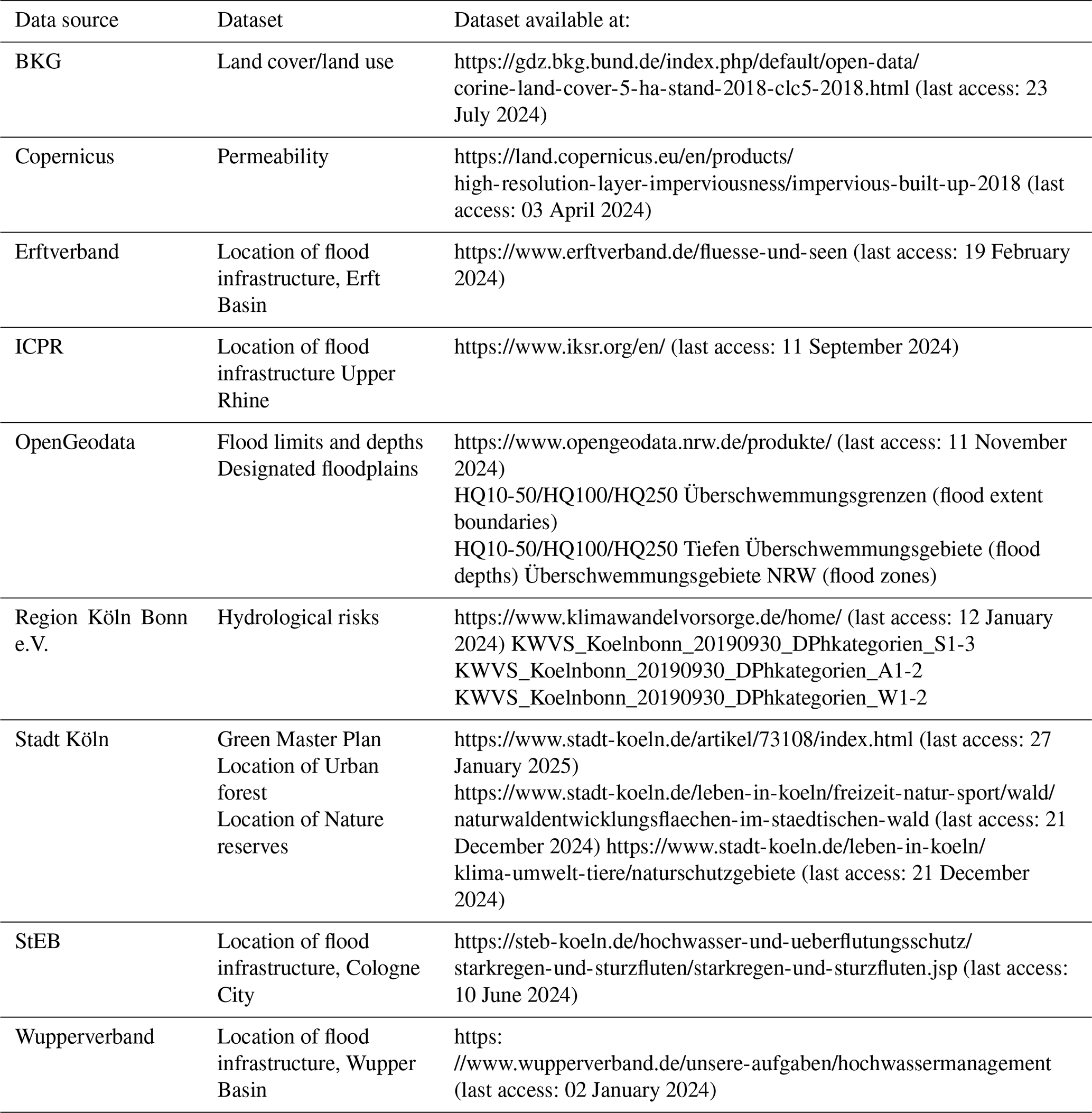
Spatial data available through state and federal German government bodies were used to identify the spatial extent of hazards, land cover, protected areas, and designated floodplains. The Copernicus permeability layer of the European Commission was used to illustrate the impermeable areas in Cologne City. Using the information available from the ICPR, Cologne city, and the water authorities, new layers were created to display the existing and planned NbS.
3.2 Layer creation to document hazards, landscape characteristics and the existing and planned NbS
NbS identified for flood mitigation include retained floodplains, existing and planned retention/detention basins, renatured meanders, and associated reconnected floodplains across Cologne City (and upstream along the Rhine), as well as in the Cologne Region of the Wupper and Erft catchments. For pluvial/stormwater floods in Cologne City, a layer was created to show the measures planned to increase urban green areas and stormwater retention areas. NbS were categorised through assessment of the NbS type, degree of engineering or naturalness, flood reduction capacity, co-benefits and potential risks. This recognises the uniqueness of each NbS feature and allows for comparison, further assessment and monitoring to preserve the flood protection capacity and co-benefits that they provide into the future.
All spatial analysis was carried out in QGIS version 3.44.3. QGIS is an open-source geographic information system. Basin delineation, elevation and slope analyses were carried out using the USGS (2014) and NASA (2013) Digital Elevation Model (DEM). The DEM is a digital elevation topography dataset derived from the Shuttle Radar Topography Mission (SRTM) in 2000 and has a 1 arcsec resolution (30 m). Slope percentages were extracted using the DEM in Raster Analysis and then reclassified via the Toolbox Raster Analysis to generate slope classes of 6 %–15 %, 16 %–25 %, 25 % and greater. The raster was subsequently converted to vector format using the Raster Conversion tool to allow for more display options.
The flood impact of each NbS was quantified where possible. This is often reported by the flood management authorities in the case of retention/detention basins, but not for renatured meanders or bank structures and reattached floodplain sections, as flood management is not the main purpose of their implementation. The capacity for retained floodplains along the Rhine River to absorb floodwaters has been calculated for this paper, but this water is not contained so a flood peak reduction cannot be reported; it is simply overflow from the main channel. The calculation involved clipping the OpenGeodata (n.d.) flood depth layers (HQ10-50 and HQ100) using the Vector Geoprocessing tool with the NbS retained floodplain layer as the overlay. The area for each depth layer across the floodplain was calculated using the Open Field Calculator and exported as a CSV file. The depth of each feature was multiplied by the area, and then summed to calculate the cubic water volume.
The maps from this research are shown in Figs. 1, 2 and 3 and Table 2.
3.3 GIS-analyses to select locations suitable for additional NbS
The Topographic Wetness Index (TWI), used to identify areas prone to soil saturation and runoff accumulation by integrating terrain and hydrological data, was calculated to guide potential NbS site selection in the Wupper area with sloping terrain. TWI has been used to identify optimal sites for urban flood reduction NbS, to determine flood prone zones in meandering river landscapes, and to predict forest species composition based on soil moisture variation (Allende-Prieto et al., 2024; Ghahraman et al., 2023; Kopecký et al., 2021). The Topographic Wetness Index (TWI) was calculated using the reprojected and filled DEM (USGS, 2014; Weng et al., 2009). The tangent of the slopes was calculated in the Processing Toolbox, using the slope, aspect, curvature tool, creating a new layer. The DEM and slope in radians were then used as input layers to the System for Automated Geoscientific Analyses (Conrad et al., 2015) Terrain Analysis – Morphometry tool (Slope, Aspect, Curvature) and Topographic Wetness Index in the Processing Toolbox. The standard method was used to process the TWI layer. Total catchment area (TCA) was calculated and divided by the calculated flow width (FW), and the results were divided by the slope in radians and then multiplied by the natural logarithm to give the TWI for each pixel (Allende-Prieto et al., 2024; Kopecký et al., 2021). TWI values ranged from 4.1 to 16.4. The TWI layer was then further processed to show only TWI cells ≥ 9 (highest 50 %) and ≥ 11 (highest 70 %) which were polygonised to aid display purposes. The results of the TWI spatial analysis indicate areas where runoff is more likely to occur due to higher soil moisture based on topographic controls.
To analyse riparian land use in the Erft area, the European Commission's Coordination of Info), and river lines from Region Köln Bonn (2019) were refined and modified. A buffer zone of 10 m on either side of the river lines was created using the Buffer Geoprocessing tool. A 10 m buffer zone was chosen as a minimum to cover the legislated 5 m of riparian buffer strip on each side of the river (Umweltbundesamt, 2012). The Vector Intersection tool was then used to create intersections with the CORINE land cover layers (BKG, 2021) for CLC class 2 (agricultural land use) and CLC class 1 (urban land use) to indicate areas where little to no woody riparian vegetation exists in the riparian zone. The lack of woody vegetation was verified using the Google satellite imagery in QGIS. To calculate sinuosity, the Erft water line was traced with the measure line function in QGIS, and the channel length (L) divided by the straight-line length of the river (l). An index score of ≥ 1.3 indicates a sinuous river and ≥ 1.5 indicates a meandering river (Hohensinner et al., 2018). The maps from this research are shown in Figs. 4 and 5.
4.1 Geomorphologic-hydrological conditions as a basis for NbS interventions
An essential foundation for designing effective NbS interventions is understanding the geomorphological and hydrological conditions across the catchment and urban landscapes studied. Our spatial analysis (Fig. 2) reveals significant differences in elevation and slope between Cologne city and the Wupper and Erft basins.
Cologne is situated within the Rhine floodplains and low-lying Rhine terraces of the Cologne Bay, with much of the city built on the wider floodplain extending directly to the river's edge. Contrastingly, the Wupper Basin features higher topography characterized by numerous slopes between 16 %–25 % and steeper, with many valleys hosting the Wupper, Dhünn, and other smaller streams. The Erft Basin within the study area generally exhibits lower elevation and predominantly gentle slopes under 6 %, but includes highly canalised and constricted river sections, with soils extensively modified by long-standing agricultural use. These geomorphological differences are directly linked to variations in flood hazards and determine the suitability of specific NbS types.
Our mapping indicates that the major flood hazard in Cologne relates to Rhine River floods, which typically develop slowly due to the river's large catchment scale, enabling early warning and flood preparation. Many engineered flood protection measures, such as mobile walls and dikes, have been installed in recent decades to reduce flood risk. However, our spatial data also highlight an increasing risk of stormwater flooding associated with ongoing urban development, which reduces permeable soil and green space availability. This urbanization intensifies surface runoff and limits natural water storage capacities.
In contrast, the more elevated and sloping areas within the Cologne District – including the Erft and Wupper basins – are influenced by fast-moving water flow concentrated in narrow, channelized rivers and numerous small tributaries. For example, in the Rhein-Erft-Kreis within the Erft Basin, runoff is often concentrated into highly straightened and restricted river channels, increasing flood velocity and risk. Similarly, in the Rheinisch-Bergischer Kreis within the Wupper Basin, many small tributaries rapidly convey runoff from steep slopes, converging near the city of Leverkusen and contributing to flood hazards.
Vegetation-based NbS, including riparian buffer strips, floodplain reforestation, and slope reforestation, are particularly applicable in the higher relief central Wupper Basin. These measures provide critical soil stabilization while reducing runoff volume and velocity on slopes.
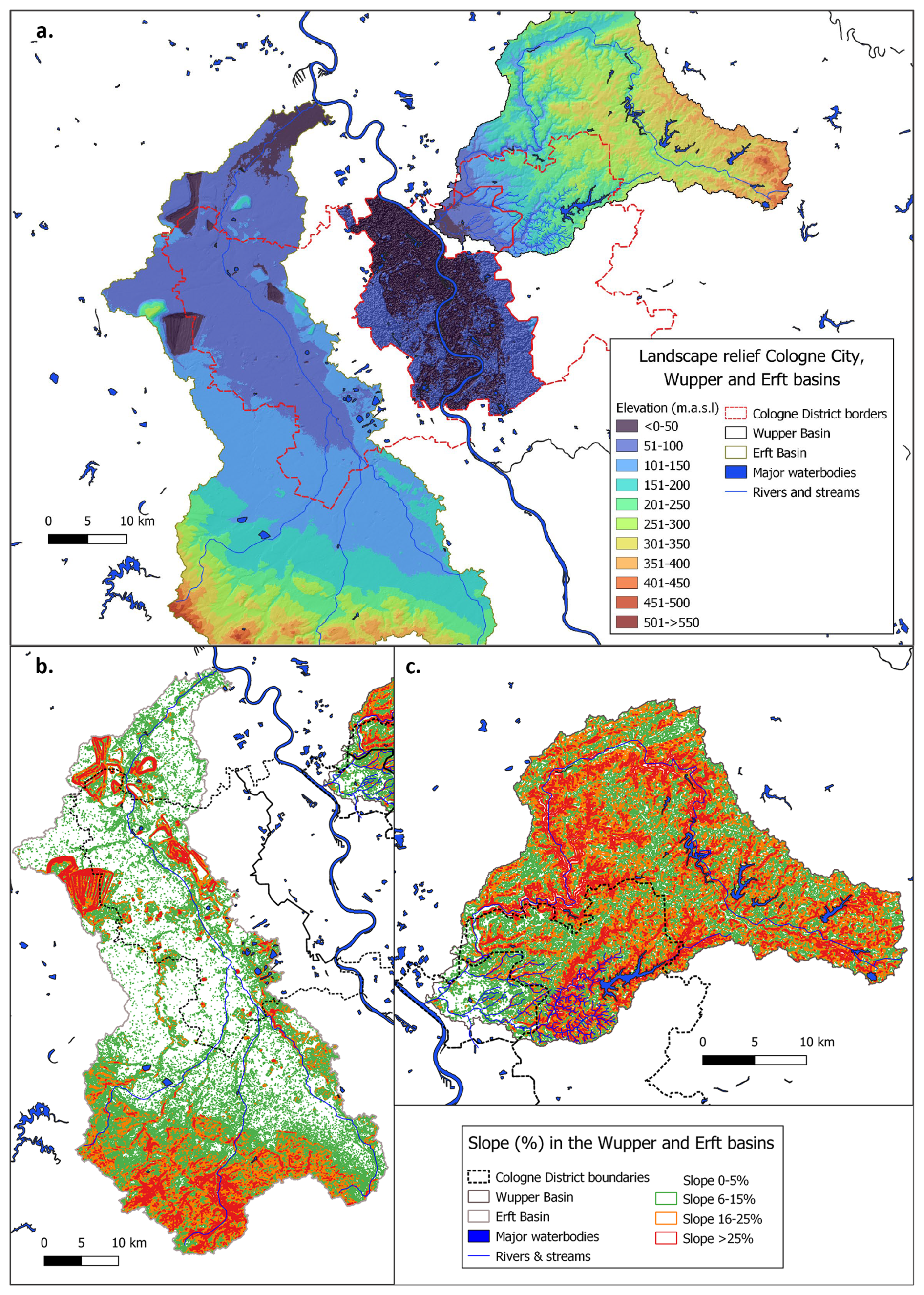
Figure 2(a) Elevation in meters above sea level (m.a.s.l) of the three study regions in the Cologne District. (b) Slope classes in the Erft Basin; (c) slope classes in the Wupper Basin. Data sources: Geodata © BKG (2021), Diva-GIS, NASA (2013), Region Köln Bonn (2019), and USGS (2014). Processed in QGIS 3.44.3.
4.2 NbS for Rhine flood mitigation
The Upper Rhine, upstream of Cologne, currently has a total flood water retention capacity of 157.1 million m3 in the form of hybrid and blue-green retention polders. Due to an ongoing dike relocation strategy, the closest fifteen (from Strasbourg) are shown in Fig. 3 (right). The Middle Rhine has no retention or detention basins as the river is constricted within the Rhine Gorge, which rises to mid-sized mountains on both sides, leaving few suitable areas for basin construction. The addition of the current retention capacity in the city of Cologne brings to the total retention capacity downstream to Cologne to 161.6 million m3. Including the planned retention area Worringer Bruch (29.5 million m3) and others in the Upper Rhine, flood retention/detention from the Upper Rhine to (and including) Cologne is expected to total around 339.7 million m3 by 2027.
The extent to which flood infrastructure, such as retention/detention basins, located upstream of Cologne, reduce the impacts of flooding in Cologne City is not precisely quantifiable. This is because floods in such large river basins can vary based on rainfall in different tributaries, local channel characteristics, and management decisions on the operation of flood reduction infrastructure. While retention/detention basins have a greater local impact on floodwaters, the detention or retention of water upstream of Cologne City can reduce, to some extent, the flood peak downstream, especially given larger capacities such as those in the Upper Rhine. However, if floodwaters originate or are significantly increased by the large tributaries that join the Rhine in the Middle or Lower Rhine, such as the Moselle, flood retention in the Upper Rhine is ineffective in reducing the flood peak at Cologne.
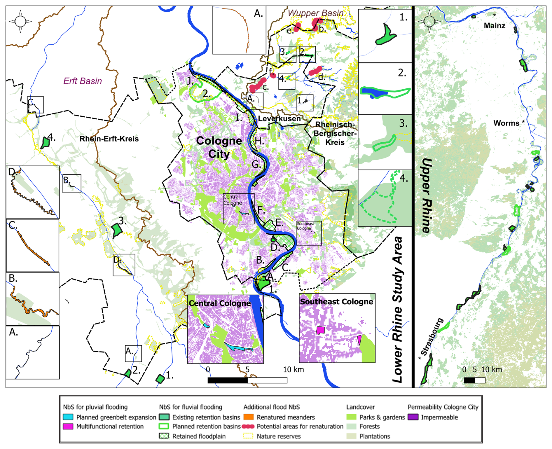
Figure 3NbS in the Cologne Region (left) Lower Rhine including Cologne City, Leverkusen, Rheinisch-Bergischer Kreis (Wupper Basin) and Rhine-Erft-Kreis (Erft Basin). NbS in the Upper Rhine (right). The Middle Rhine, situated between the Upper and Lower Rhine sections is not shown on this map. Data sources: Geodata © BKG (2021, 2024), Copernicus (2020), ICPR (2021), Erftverband, Region Köln Bonn (2019), Stadt Leverkusen (2025), StEB Köln (2024b), Wupperverband, NASA (2013), USGS (2014), and OpenGeodata. NRW. Prepared in QGIS 3.44.3.
The city of Cologne has a narrow radial layout in its inner, flood-prone urban area, resulting in few undeveloped spaces in the city centre. As a result, flood defences in the inner city include a combination of engineered retaining walls (mobile), dykes, and pumping stations. NbS consist of flood retention/detention basins (one established and one planned), which are located in the very south and north of the city due to land availability, and retained floodplains. Flood retention basins are designed to reduce peak flood levels and are activated when river heights reach 11.3 and 11.7 m, respectively. In contrast, retained floodplains accommodate smaller floods by allowing excess water to spread naturally without causing significant impact to the city. Figure 3 illustrates the NbS in Cologne City (centre map) that primarily serve to protect the city from Rhine floods.
NbS can vary in terms of the degree of naturalness and with regards to how it is combined with engineered structures. As a result, different NbS can offer varying levels of flood protection and different co-benefits in form of ecosystem services. In Table 2, the NbS are categorised and described in terms of their feature(s), type, degree of naturalness, water retention capacity (cubic meters or hectares) and/or modelled flood peak reduction (if available), co-benefits (ecosystem services) and potential risk to the local environment.
Table 2NbS for Rhine River flood mitigation Cologne city.
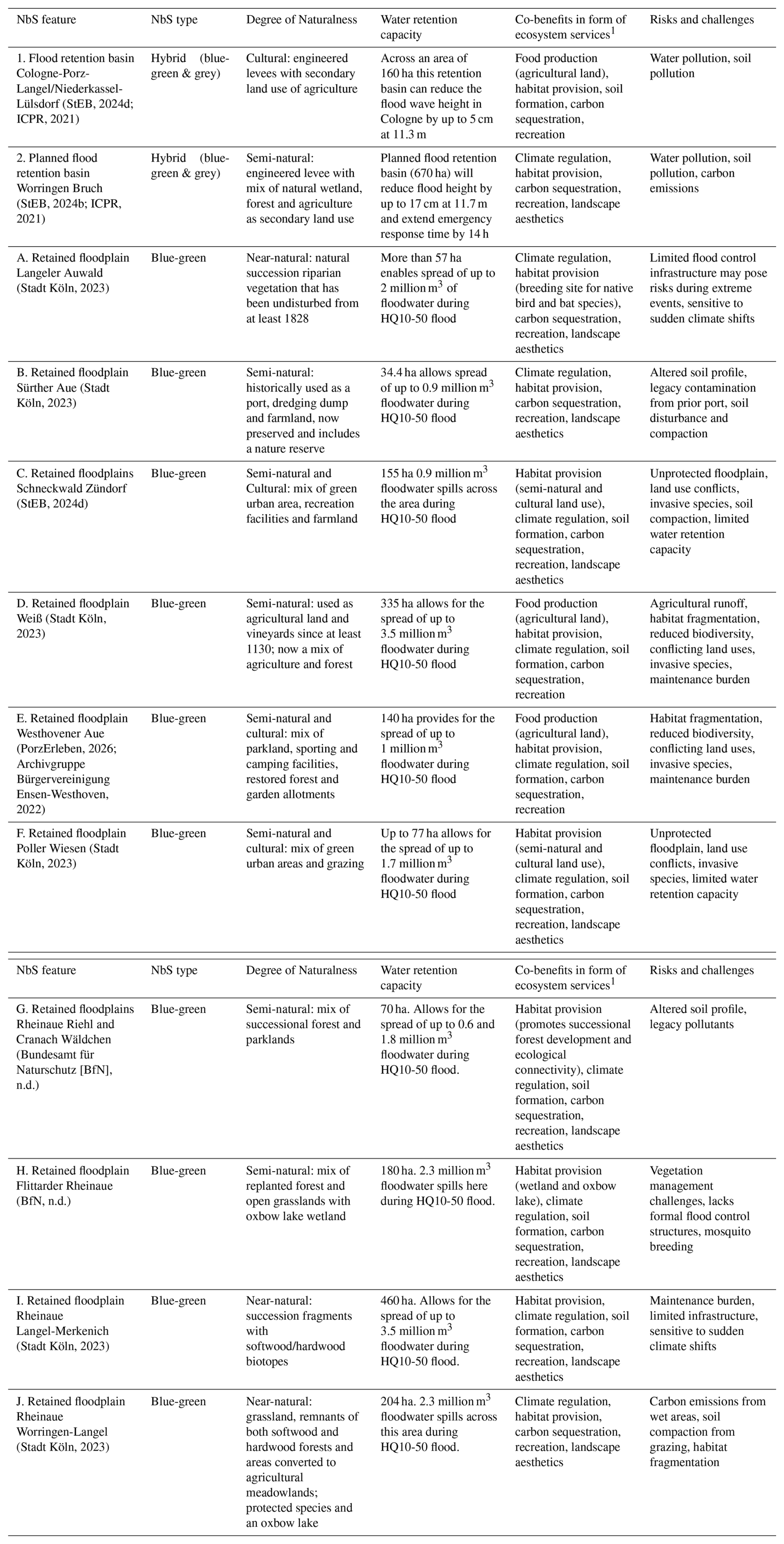
1 The catalogue includes important provisioning, regulatory and cultural services in accordance with the descriptions of the measures, but does not claim to be exhaustive
4.3 NbS for stormwater inundation mitigation in the city of Cologne
Figure 3 (centre) shows the location of NbS that can reduce the impacts of stormwater overflow and flash floods. NbS for pluvial flooding includes completion of the inner green belt/green corridor which circles the city, and implementation of a stormwater detention basin. Pilot areas featuring a green stormwater detention basin within a suburban park and stormwater collection tanks have been implemented in Eil-Süd in the southeast of the city. On a broad scale, the green rings around the city act to soak up excess rain and stormwater in between the largely impermeable urban areas, while the NbS pilots target specific urban sites that frequently flood after heavy rainfall. These NbS include existing forests, grasslands, parks and gardens, and the planned extension of the green belt and pilot multifunctional retention areas (Table 3). In addition, Fig. 3 shows the potential for unsealing, green roofs and further expansion of the green belt/green corridor concept due to the concentration and extent of impermeable land cover, especially in central and southeast Cologne.
Table 3NbS for pluvial/stormwater flood mitigation in Cologne City.
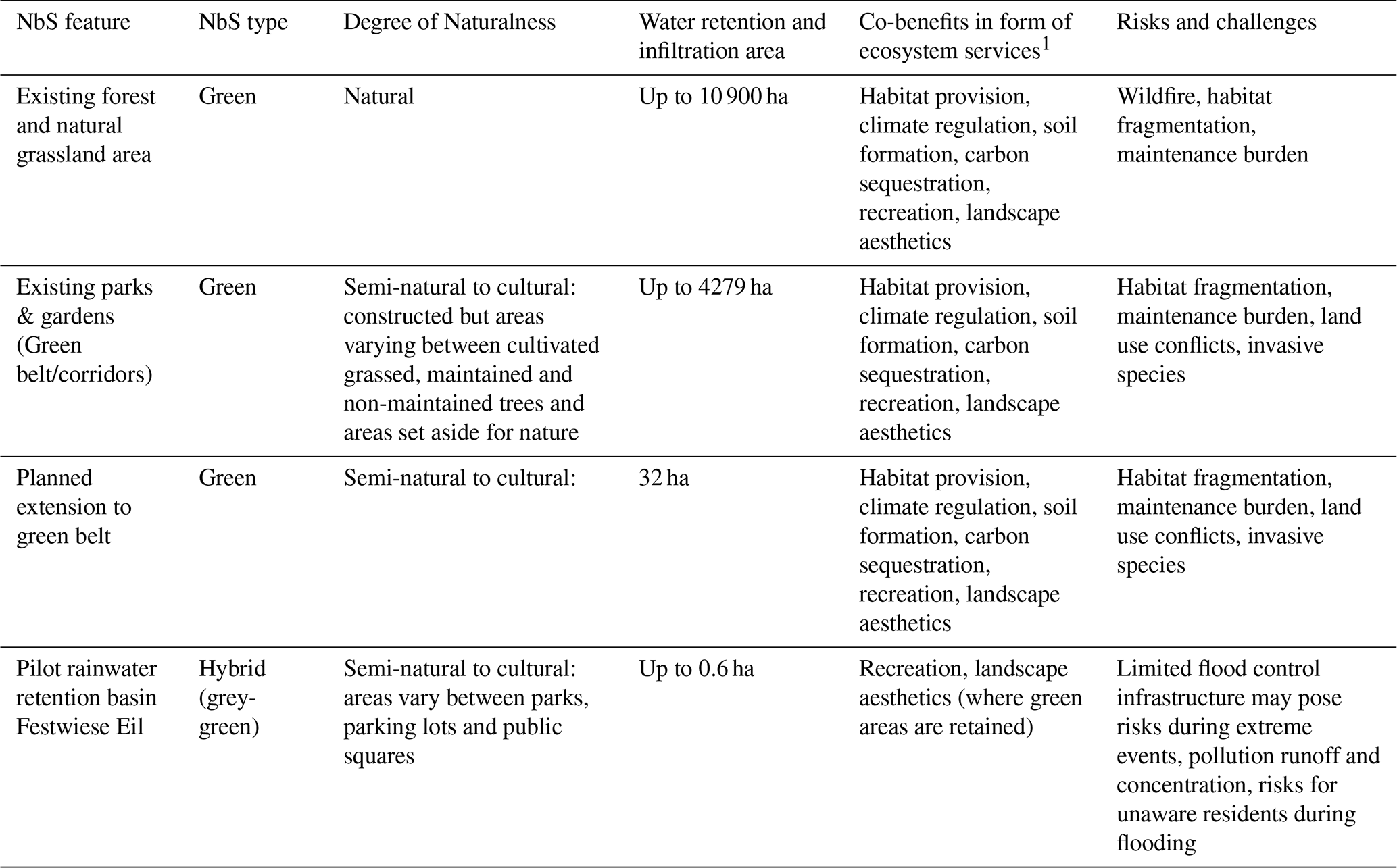
1 The catalogue includes important provisioning, regulatory and cultural services in accordance with the descriptions of the measures, but does not claim to be exhaustive. The NbS features are based on Stadt Köln, 2023 and StEB, 2024c
4.4 NbS for flood mitigation in the Wupper Basin
Figure 3 (centre right) shows the location of existing and planned NbS in the city of Leverkusen and the Rheinisch-Bergischer Kreis. NbS in the Cologne District section of the Wupper catchment include small retention basins, two existing (1 and 2 in Fig. 3) and one planned and sections of renatured stream, one existing (A in Fig. 3.) and several sites identified for potential restoration and renaturation. Many areas of natural riparian vegetation in the catchment are protected and these, as well as the scattered broadleaf forests, act as natural NbS retaining water in the landscape and reducing rainfall runoff. Most of the retention basins across the wider catchment have a limited capacity and are located on the Wupper and its tributaries in the upper reaches of the catchment area outside the Cologne district, e.g., in the municipalities of Wuppertal and Wermelskirchen. Small retention basins in these locations are useful for local urban areas but would have little impact on the downstream locations such as Leverkusen or the smaller cities in Rheinisch-Bergischer Kreis. The existing and planned NbS are illustrated in Fig. 3 and described and categorised in Table 4.
Table 4NbS for river flood mitigation in the Wupper Basin.
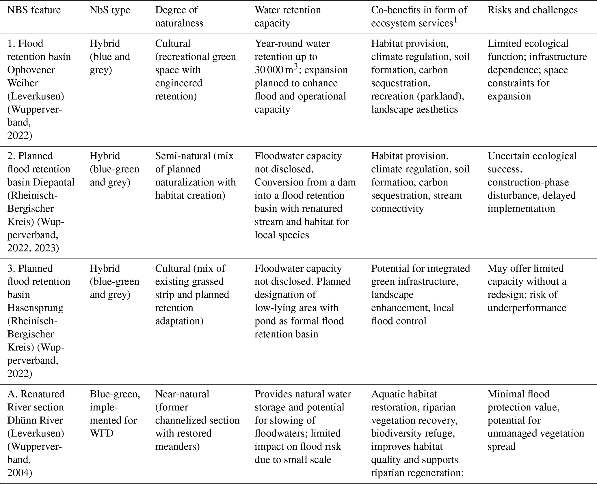
1 The catalogue includes important provisioning, regulatory and cultural services in accordance with the descriptions of the measures, but does not claim to be exhaustive.
In addition to the already restored river section, the Wupperverband has identified additional sites for renaturalization. A number of these are within the Rheinisch-Bergischer Kreis and Leverkusen regions. This includes the Wupper from Auer Kotten to behind Untenrüden in Solingen (B in Fig. 3) and the Wupper below Opladen (C in Fig. 3). The sections of the Bornheimer Bach/Großhamberg at Burscheid (D in Fig. 3) and the Leysiefen in Leichlingen (E in Fig. 3) are also marked for potential restoration and renaturation. Such measures can work to increase the area available for the river to spill during floods, enable runoff collection for dry periods, and increase habitat and species diversity. In addition, the damage that occurred particularly in Opladen and Schlebusch during the July 2021 floods suggests that these areas should be the focus of additional NbS measures.
During the heavy rainfall event in July 2021, inundation caused by the Wupper and the Wiembach, a stream that flows into the Wupper in Opladen, resulted in major property damage in the Leverkusen district of Opladen. The city of Leverkusen is currently conducting a feasibility study to explore blue, green, and grey infrastructure options that can reduce flooding impacts and expand natural areas. As part of this effort, two potential sites have been identified. The first area Pintsch-Oelgelaende (4 in Fig. 3) located at the conjunction of the Wiembach and the Oelbach, and the second potential is for the widening of the Wiembach Allee (F in Fig. 3). However, given the prevalence of slopes and streams that flood from heavy rainfall runoff within the Wupper Basin study area, it is evident that NbS, which act to reduce runoff on the slopes are suitable in these sections of the basin.
4.5 NbS for flood mitigation in the Erft Basin
Figure 3 (left) shows the location of existing and planned NbS for floods in the Rhine Erft Kreis and Table 5 provides a brief characterization of the interventions. There are four nature-based retention/detention basins within the study area. Both Mödrath and Garsdorf retention basins (3 and 4 in Fig. 3) occupy former open-cast mining sites that have been repurposed as green urban areas, which can also hold floodwaters. Compared to the Wupper Basin, there is little remaining natural vegetation along the Erft waterways, with only small fragments of remaining and protected riparian vegetation. However, several small sections of the Erft River and its tributaries have been restored and renatured, where bank protection and levees have been removed and meanders or instream islands have been recreated. Four renatured sections of stream, including meander creation at Weißen Burg (A in Fig. 3), renatured bank structures at Grevenbroich Frimmersdorf (C in Fig. 3), and the renatured meanders with re-attached floodplain at Vogelwäldchen and Gymnich (B and D in Fig. 3), are located in the central and northern sections of Rhine-Erft-Kreis. Renaturing acts to increase the ecological status of the waterways and to provide natural water retention by slowing the flow of the river and providing the space for water storage in the floodplains and wetlands. While in the south of Rhine-Erft-Kreis, between the Horchheim detention basin (1 in Fig. 3) and the renatured meanders on the Rotbach tributary Weißen Burg (A in Fig. 3) to Gymnich (D in Fig. 3), no further NbS are in place, despite this area experiencing extensive erosion during the July 2021 floods.
Table 5NbS for river flood mitigation in the Erft.
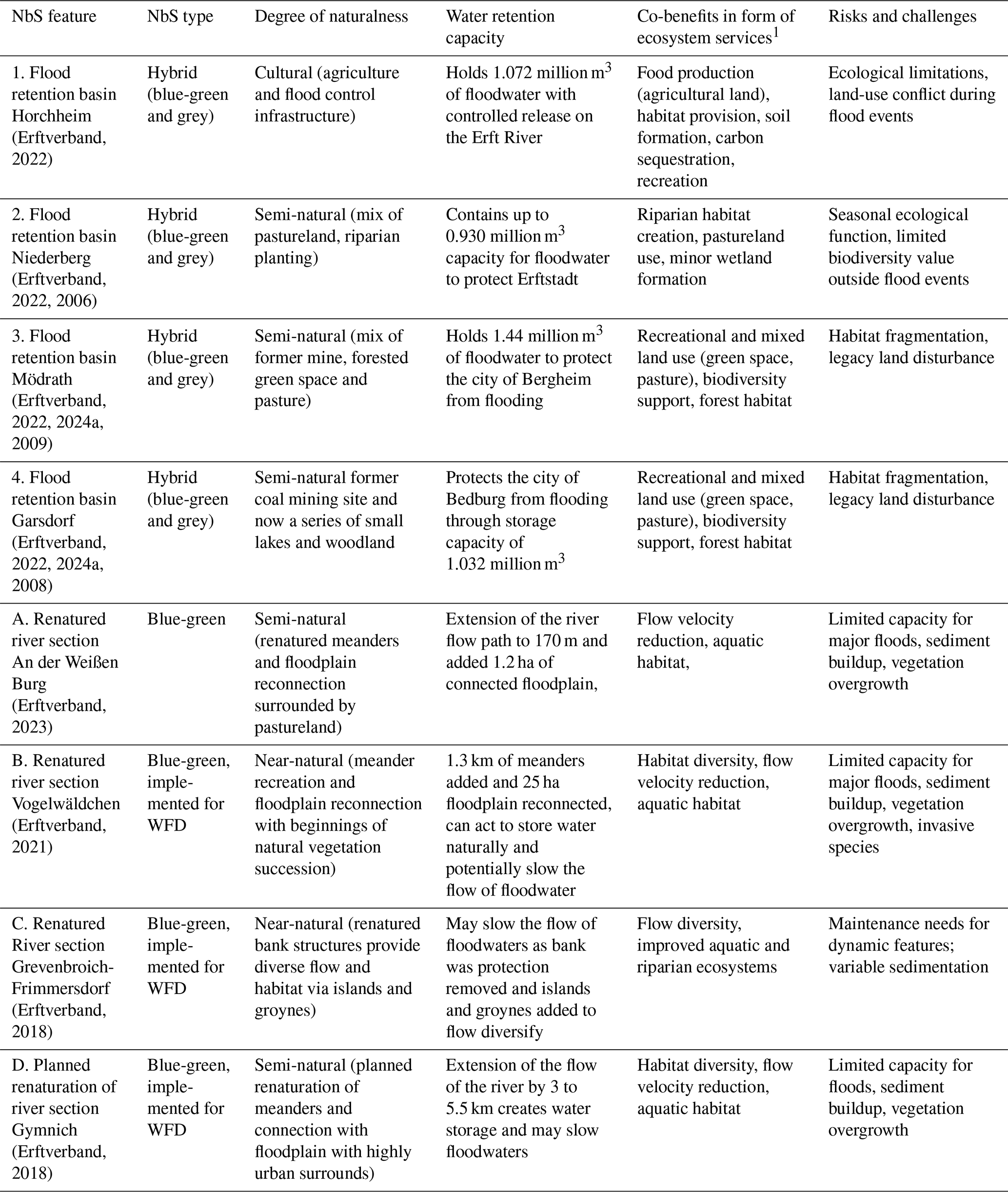
1 The catalogue includes important provisioning, regulatory and cultural services in accordance with the descriptions of the measures, but does not claim to be exhaustive.
4.6 Identification of additional sites for NbS interventions in the Erft and Wupper basins
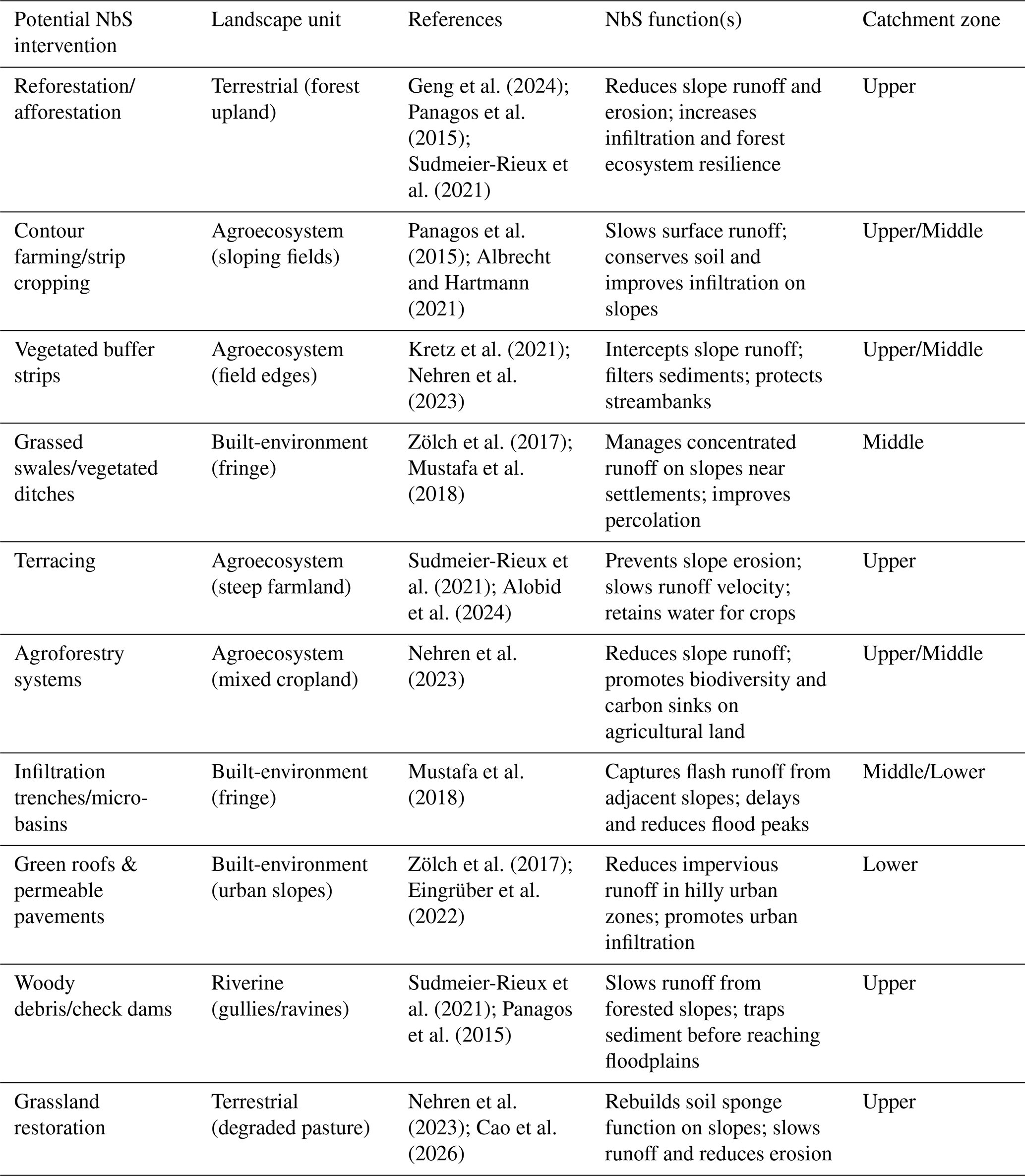
Based on landscape GIS analysis (see Fig. 2 a, b and c) and the hazard reduction needs identified by the outcomes of the July 2021 floods, sites in the Erft and Wupper basins are suitable for a broad range of additional NbS interventions. Depending on the existing land cover, these sites would be suitable for a range of NbS including unsealing with permeable pavements, increasing water retention with vegetated swales, infiltration trenches, rain gardens, filter strips, and various rainwater storage NbS. Indicators, land use/land cover, and suitable NbS are listed in Table 6.
Table 6Potential NbS interventions categorized by landscape unit, their core functional mechanisms. The catchment zone specifies the position within the catchment where the intervention is most applicable.
In the Wupper Basin, as discussed previously, the dominating feature is slopes. Areas of high TWI are found on slopes parallel to the waterways across both agricultural and urban landscapes within the study area. Across Leverkusen and Rheinisch-Bergischer Kreis in the Wupper Basin, many small waterways rise, bringing a high flood risk to the settlements after heavy rainfall. The sites shown as red boxes in Fig. 4a and b indicate suitability for NbS, including revegetation that will act to increase soil water retention on sloping agricultural land. Sites indicated by the purple boxes are location of high TWI in urban areas and as such are suitable for NbS measures such as swales, vegetated ditches, infiltration trenches, rain gardens, permeable pavements, and others, depending on the specific urban land use.
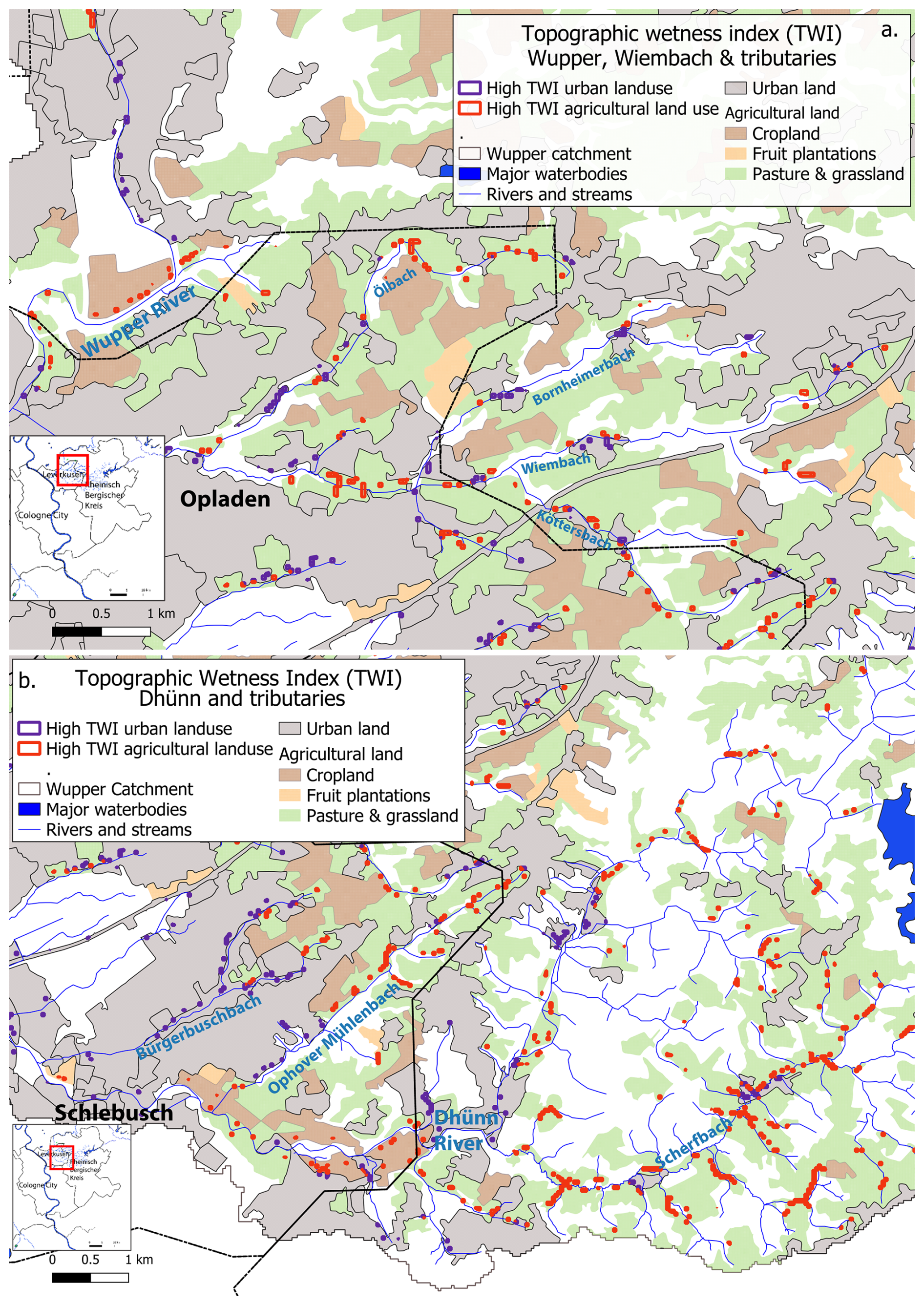
Figure 4Sites of high TWI on agricultural and urban land affecting (a) Opladen and (b) Schlebusch. Data sources: Geodata © BKG (2021), Diva-GIS, and USGS (2014). Processed in QGIS 3.44.3.
In the Erft Basin, another preliminary analysis was carried out based on the plain landscape, land use, soil type, and the erosion that occurred in this area during the July 2021 floods (see Sect. 2). GIS analysis of this river section reveals low river sinuosity and minimal riparian vegetation. Furthermore, loess soils are widespread throughout the Erft Basin, much of which have been used for agriculture. In this landscape the risk of soil erosion is high due to the soil type and rapid floodwaters moving through the plains from the higher elevations in the south of the basin. Figure 5 illustrates the Erft River upstream of the meander restoration site at Gymnich (D in Fig. 3), along the Rotbach tributary to Erftstadt, and to the junction of the Erft and Swist rivers in the southernmost part of Rhein-Erft-Kreis.
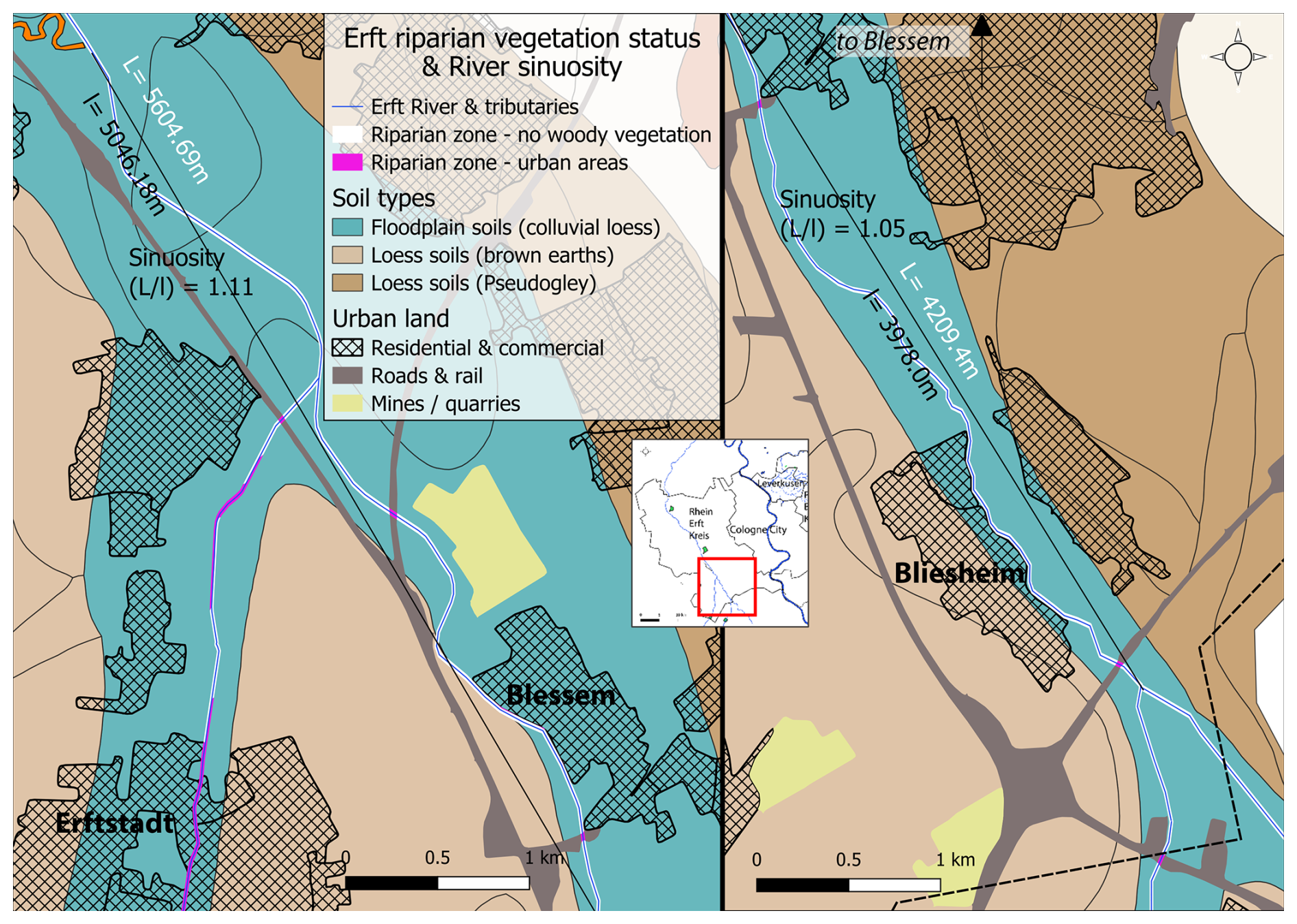
Figure 5Riparian zones on the Erft devoid of woody vegetation and measure of river sinuosity; Data sources: Geodata © BKG (2021, 2024), and OpenGeodata. Processed in QGIS 3.44.3.
Analysis of riparian vegetation, shown with the white buffer line, indicates that this stretch of river is lacking substantial woody riparian vegetation. This lack of riparian vegetation means that the river bank and beyond are vulnerable to erosion, especially because the soils (as shown in Fig. 5) are formed from highly fertile, but erodible loess sediments. Furthermore, the sinuosity of the river from Gymnich to Blessem and from Blessem to Bliesheim is very low at 1.11 and 1.05 respectively, indicating that these river stretches are not meandering ( 1.5) or even mildly sinuous ( 1.3). This analysis supports further efforts of meander renaturation at locations along this stretch that are suitable with regards to land ownership and zoning.
The Rhine River has long posed a flood risk to the communities along its banks, including the administrative district of Cologne, with the metropolis of Cologne and several other large cities, such as Bonn and Leverkusen. Cologne has experienced several severe floods, which are documented from the Middle Ages and more recently in 1993 and 1995, when floodwaters reached critical levels and caused extensive damage. In response the city of Cologne has developed a robust flood protection system that includes elevated flood walls, mobile barriers, pumping stations, and improved drainage systems. In addition, outside the densely built-up inner city, natural floodplains are being used and old river branches have been reactivated and are used as nature-based solutions (NbS) or hybrids combined with engineered infrastructure.
NbS and hybrid NbS offer a promising approach to enhancing flood resilience by utilizing natural processes and ecosystem services (Debele et al., 2023). In the city of Cologne, for example, the Westhovener Aue floodplain in the south of Cologne not only helps to reduce flooding, but promotes biodiversity and offers recreational opportunities (Archivgruppe Bürgervereinigung Ensen-Westhoven, 2022). This will also be the case with the Worringer Bruch project currently under construction in the north of Cologne (StEB, 2024b). When completed, the Cologne City will be protected from flood peaks of up to 11.3 m in the south and up to 11.9 m in the north of the city. These flood heights have a statistical return period of around 100 (HQ 100) and 200 years (HQ 200), respectively (StEB, 2024a, b). These multifunctional landscapes underscore the importance of NbS in balancing flood management with ecosystem and social benefits. In the Netherlands, similar measures have been successfully implemented along the Waal and Meuse rivers as part of the Room for the River Project (Dutch Water Sector, 2019), and other European countries, such as the United Kingdom with the Thames Estuary 2100 Plan (United Kingdom's Government, 2019), are similarly taking steps to combine flood protection with nature conservation and recreation.
To address stormwater runoff in Cologne City, flood managers, the StEB, are also using a mix of NbS and grey infrastructure. This infrastructure is used to reduce pluvial flooding in residential areas, including the use of a park for stormwater retention, and installation of rainwater storage underneath open spaces, including that of a car park and public square (StEB, 2024d). In addition, the Stadt Koeln (2023) strategy is to ensure conservation of the existing green areas in the green belt/green corridors concept, in which two concentric green area bands circle the city, and where possible complete the green belt in areas of minimum coverage. These measures are the starting point for a larger climate change adaptation program in the city of Cologne, which includes modifications to grey infrastructure to hold more stormwater runoff, and support for unsealing and green roof installations, which contribute to the prevention of stormwater flooding at the local scale (StEB, 2024d).
The city of Cologne is protected for fluvial floods up to a 1 in 200-year statistical return period thanks to a combination of engineered infrastructure, NbS, early warning systems, and evacuation plans. However, the flood disaster of summer 2021 showed that other parts of the Cologne administrative district, such as the Erft and Wupper river basins in the Cologne administrative district are not well protected from heavy rainfall induced flooding (Fekete and Sandholz, 2021; Mohr et al., 2023; Neitzke et al., 2025). This was the case for the city of Leverkusen, which lies at the confluence of the Wupper and the Rhine, as well as smaller streams and rivers that flow into the Wupper. Our investigations show that the smaller tributary catchments of the Erft and Wupper to the west and east of Cologne city provide different challenges. Heavy rainfall over short time periods can overwhelm natural and man-made drainage in these catchments, producing highly damaging, fast-moving floods. River floods in the smaller tributary catchments of the Wupper and Erft operate on a different scale and time-frame to the multi-landscape traversing Rhine River. As such these river systems are subject to fast floods, such as those that occurred in July 2021 and even flash floods (see Fig. 1), which are often the result of climate change-enhanced convective rainfall (Tradowsky et al., 2023), and high risk for inhabitants based on exposure or vulnerability.
Figure 4 shows existing, planned, and potential NbS identified for Wupper and tributary floods. Both Rheinisch-Bergischer Kreis and Rhine Erft Kreis contain a large percentage of agricultural lands on the periphery of the rivers and streams and small cities along the waterways. These factors provide a range of challenges but also opportunities, in particular for runoff reduction. In terms of geomorphology, however, the two are quite different. These landscape and hydrological variations result in distinct opportunities and constraints for NbS implementation. In flatter areas such as Cologne city and the lower Erft Basin, retention/detention basins, secondary channels, floodplain reconnection, and meander renaturation are most suitable. Our spatial analysis and field observations identified barriers to deployment, which include intensive land use, ongoing urbanization, and notably, fragmented land ownership patterns, which restrict large-scale or coordinated NbS interventions in these floodplains.
With GIS analysis of geomorphology, streamflow and runoff controls, this study illustrates how additional NbS interventions can be identified. In the Wupper catchment across Leverkusen and Rheinisch-Bergischer Kreis, slope characteristics are used to calculate the topographic wetness index (TWI). TWI is used to define potential runoff pathways across sloping land, and is calculated to demonstrate the initial spatial analysis step within the sequence of steps required to design placement of NbS interventions. The TWI indicates preferential flow paths for runoff based on topography, and illustrates suitable sites for NbS based on revegetation along flow paths to reduce runoff. This includes buffer strips, hedgerows, and tree rows (planted across the slope), and a range of agricultural practices such as no till, reduced or strip tillage and reduced grazing pressure that act to increase soil water retention and reduce rainfall runoff (Borin et al., 2010; Laufer et al. 2016; Madarász et al., 2021; Marshall et al., 2014; Meijles et al., 2015; Nerlich et al., 2013).
For Rhein-Erft-Kreis, the status of river sinuosity and riparian zone land use is analysed to inform NbS design. The Erft River, like many small and large rives across Germany, is highly straightened and canalised. While sections of the Erft River have been renatured with meanders and reconnected floodplains, the Erft below the junction with the Rotbach, as shown in Fig. 5, remains canalised with low to no riparian vegetation. Loess soils, which are well known for their fine grain size, and high vulnerability to structure loss and erosion, are prolific throughout the Erft Basin (FAO, 2015; Lehmkuhl et al., 2018). Riparian vegetation supports riverbank cohesion against erosion, provides natural runoff reduction and in addition provides roughness to slow overbank flows during flooding (Cooper et al., 2021; Murphy et al., 2021). As a result, the lower section of the Erft River in the study area is suitable for NbS measures including re-meandering and riparian revegetation to slow floodwaters and stabilise riverbank soils. While this is not to suggest that they are the only NbS suitable for flood mitigation, our analyses based on landscape and land use characteristics suggest that slope revegetation in the form of buffer strips, hedgerows, tree rows are suitable in the Wupper Basin while meander renaturation and riparian zone revegetation would be highly suited in the analysed section of the Erft Basin. Priority should be given to drought-tolerant native tree species to align with conservation goals. Nonetheless, implementation is challenged by fragmented ownership, conservation area restrictions, and urban development pressures, especially in the more urbanized downstream zones like Leverkusen, where the challenges mirror those faced in Cologne and the lower Erft Basin. It should also be pointed out that further analysis, including field-based scoping studies, would also be required prior to further intervention design and implementation.
This mapping and cataloguing method provides not only an overview of existing and planned NbS but also serves as a forward-looking tool adaptable to changing conditions – a crucial feature given the increasing impact of climate change. Looking at climate models and the study area located in western Germany, it can be assumed that extreme climatic events with stationary heavy rainfall events in summer and longer periods of drought will continue to increase (Tradowsky et al., 2023), which will further increase the risk of rapidly forming floods and even flash floods in the side valleys of the Rhine (Laux et al., 2025). The risk is exacerbated by the fact that, due to the droughts, bark beetle infections and wind throws of recent years, many conifers, especially spruce (Picea abies) and, in some cases, deciduous trees have died, and young secondary forests are currently forming in many places (Ministerium für Landwirtschaft und Verbraucherschutz des Landes Nordrhein-Westfalen, 2024). As a result, some slopes are only sparsely vegetated and are susceptible to erosion and rapid slope runoff. In addition, the soil has become crusted after the long summer droughts, which reduces infiltration capacity and increases slope runoff (Doerr et al., 2000).
Considering these rapid climatic and ecological changes, there is a growing need for more integrated flood protection measures at the landscape level, which include not only river floodplains but also hillside areas in flood protection (Stein et al., 2024), where measures like afforestation, terracing and soil stabilization could significantly reduce runoff and delay flood peaks. The current concentration of NbS in floodplain areas within the Cologne District highlights a prevalent focus on managing the floodplains of major rivers and their tributaries. These interventions, such as floodplain restoration, retention basins, and river restoration are vital for mitigating large-scale riverine flood events by leveraging the natural capacity of floodplains to absorb excess water and reduce flood peaks. However, they neglect flood risks associated with runoff and flash floods from larger slopes, which pose a high risk, particularly in the Wupper catchment area.
Floodplains naturally attract attention due to their visibility and historical impact on urban centers like Cologne. These areas are traditionally prone to significant flooding events, making them logical targets for initial flood mitigation efforts. Furthermore, floodplains provide immediate gains in flood management through interventions that can often coincide with existing land use, cultivated agricultural areas, or protected natural habitats. But gaining and retaining floodplains is also often in conflict with other demands for urban development or agriculture. For example, creating a flood retention area south of Cologne after the floods in 1993 and 1995, at an area called Langeler Bogen (1 in Fig. 3), resulted in conflicts over compensation for farmers that took years to solve (StEB, 2024b). Furthermore, regarding recent planning of a new Rhine crossing, nature-related interests of protection of species often clashes with planning or agricultural use (BUND, 2016). This is another argument to consider other types of NbS solutions rather than only focus on the floodplains. The systematic evaluation and implementation of NbS in slope areas could, therefore, represent a significant enhancement of regional comprehensive flood risk management.
The Dutch approach of Cyclic Floodplain Rejuvenation (CFR), which involves mimicking natural channel migration through interventions such as removal of softwood forests and reconstruction of secondary channels, has proven effective for floodplain vegetation management and flood risk mitigation (Baptist et al., 2004; Cornelissen et al., 2019). While CFR is currently not planned in the Cologne District – likely due to its suitability mainly for large, meandering rivers with ample space and less urbanization – the concept offers valuable insights. It could inform future adaptive floodplain management strategies where landscape conditions permit greater spatial flexibility and dynamic river restoration.
Slope areas are critical in the hydrological cycle, particularly in triggering rapid runoff and flash floods. When heavy rainfall events occur the swift movement of water down slopes can lead to severe flash floods and contribute substantially to flooding in downstream areas. Implementing NbS in slope areas has therefore the potential to drastically reduce the speed and volume of runoff (Santos, 2025; Xiong et al., 2018). These interventions could enhance soil stability and increase water infiltration, thus mitigating erosion and reducing the frequency and impact of flash flooding. Additionally, they can improve the overall landscape resilience to climate impacts including drought events, supporting biodiversity, carbon sequestration, and soil fertility.
The timeline for implementing NbS presents both opportunities and challenges in relation to increasing flood risks. Many soil- and vegetation-based measures require decades to fully develop their hydrological and ecological functions (Ruangpan et al., 2020), raising questions about their ability to provide timely protection against climate-exacerbated floods. Our analysis identifies a range of NbS measures with varying timeframes: quick-win strategies like multifunctional retention basins, green roofs, permeable paving, and floodplain reconnection can yield measurable flood reductions within short to medium terms. In contrast, afforestation, agroforestry, and soil remediation require longer periods but offer significant long-term benefits such as carbon sequestration, biodiversity enhancement, and drought resilience (Keesstra et al., 2018). Thus, a balanced portfolio combining immediate and long-term measures is essential to adapt effectively to increasingly severe hydrological extremes.
NbS themselves can be vulnerable to extreme events; floods and droughts may damage vegetation, destabilize soils, and impair NbS function, reducing effectiveness during and after such events. Recovery varies – from several years to decades – depending on species and conditions (Vicarelli et al., 2024), impacting flood risk continuity. Consequently, the cumulative benefits of NbS depend not only on their spatial distribution but also on rapid recovery and adaptive management. Our spatial catalogue helps identify critical areas where redundancy and connectivity can enhance resilience and long-term stability.
Ecological and social considerations also influence the function and acceptance of NbS. Water retention measures such as ponds, wetlands, and slow-flow zones can inadvertently create conditions that favour the establishment of invasive species or the proliferation of mosquitoes, posing challenges for biodiversity conservation and public health (Hassall, 2014; Sinclair et al., 2020). Careful design – such as flow-through systems, regular flushing, and diverse native plantings – can mitigate these risks (Hanford et al., 2020). Our mapping highlights areas where integrating such management is critical, helping to preserve NbS multifunctionality while enhancing ecosystem services and flood resilience.
Beyond flood protection, NbS provide benefits including drought adaptation, water quality improvement, biodiversity preservation, recreation, and regulatory compliance (e.g., European Water Framework Directive, Habitats Directive) (European Parliament and Council, 2000, 2024; Council of European Communities, 1992). The 2026 European heatwaves once again highlight the need for NbS, which provide a wide range of regulating ecosystem services and thus ensure resilience to both floods as well as heat and drought.
Given the projected increase in extreme weather events due to climate change, expanding the scope and scale of NbS in the Cologne District is imperative. This study provides a foundation for identifying potential areas for new interventions, particularly in the Wupper and Erft basins, where flash floods pose significant risks. Enhancing NbS upstream, especially in slope areas, could complement existing downstream efforts and provide a holistic approach to flood risk reduction. To advance this, future research could focus on the long-term monitoring and quantification of the effectiveness of NbS interventions. Moreover, developing tools for modelling and predicting flood events with NbS integration would support adaptive management strategies, allowing for real-time adjustments to intervention plans.
The integration of Nature-Based Solutions (NbS) for enhanced flood resilience in the Cologne District exemplifies a proactive response to the escalating challenges of climate change-induced flooding. Using a landscape approach, this study has identified and mapped existing and potential NbS interventions, highlighting the importance of reconnecting floodplains, enhancing riverine habitats, and implementing green-blue infrastructures to mitigate flood risks. While the use of engineered, nature-based, and hybrid solutions together with early warning systems has provided a robust framework for flood protection, the increasing frequency of extreme weather events necessitates a broader and more integrated approach. By focusing on the geomorphological and hydrological dynamics of the region, particularly in areas prone to rapid runoff and erosion, this research underscores the need for strategic NbS implementations on slopes and upstream areas. The application of the Topographic Wetness Index (TWI) provided essential spatial insights into areas of high runoff accumulation and soil moisture, guiding the identification of priority sites for slope-based NbS interventions.
This study highlights the value of the TWI as a powerful tool for spatial analysis, integrating terrain and hydrological data to identify areas prone to soil saturation and runoff accumulation. Despite its relevance, the role of NbS on slopes – critical zones for mitigating rapid runoff and flash floods – is often overlooked in flood risk management strategies, which predominantly focus on measures in floodplains. By applying the TWI, we demonstrate a method for systematically mapping and prioritising opportunities for implementing NbS in both valley floors and on slopes, offering a more comprehensive and effective approach to flood risk reduction. These interventions not only reduce flood peaks and enhance water retention but also support biodiversity conservation and provide valuable ecosystem services. Integrating slope-based NbS into flood risk management, guided by TWI-informed spatial analysis, enables a more resilient and sustainable response to the full range of flood hazards, from slow riverine floods to rapid flash floods, particularly under changing climatic conditions.
The varied implementation of NbS across different administrative and catchment levels, involving numerous stakeholders, highlights the absence of a unified framework and standard NbS terminology, complicating comprehensive planning and evaluation. While the use of open GIS tools and publicly available data offers the advantage of transferability, limitations persist in data resolution and accessibility. A defining feature of this case study is the diverse mix of NbS employed, set against a backdrop of mixed flood and drought hazards and varying landscape types. Germany's cultural readiness for green solutions is evident; however, issues such as land ownership conflicts and competing demands from agriculture, traffic, and urban development remain significant barriers. To advance flood resilience, a strategic shift toward comprehensive, catchment-wide approaches is essential. This includes greater emphasis on addressing flash floods and the synergistic impacts of drought, alongside enhanced cooperation and clarity among all parties involved in NbS deployment.
Supporting data is available on Zenodo https://doi.org/10.5281/zenodo.22662885 (Barrett, 2025).
UN contributed to the conceptualization of the study, conducted the literature review, and took the lead on writing the manuscript. ACB contributed to the literature review, writing and editing, and performed the GIS processing. PSQ assisted with the literature review and prepared the tables. AF carried out the internal review and made revisions and adjustments to the text.
The contact author has declared that none of the authors has any competing interests.
Publisher's note: Copernicus Publications remains neutral with regard to jurisdictional claims made in the text, published maps, institutional affiliations, or any other geographical representation in this paper. The authors bear the ultimate responsibility for providing appropriate place names. Views expressed in the text are those of the authors and do not necessarily reflect the views of the publisher.
We gratefully acknowledge the support of the NBSINFRA project for funding this research. The project’s infrastructure and collaborative environment were instrumental in enabling this work. We extend our sincere thanks to the anonymous reviewers for their constructive feedback, which significantly improved the quality of this paper.
This research was funded by the European Commission, EU Horizon 2020 (grant no. 101121210) “City Nature-Based Solutions Integration to Local Urban Infrastructure Protection for a Climate Resilient Society” (NBSINFRA). Funded by the European Union. Views and opinions expressed are however those of the author(s) only and do not necessarily reflect those of the European Research Executive Agency (REA). Neither the European Union nor the granting authority can be held responsible for them.
This paper was edited by Timothy Tiggeloven and reviewed by Marissa Webber and one anonymous referee.
Albrecht, J. and Hartmann, T.: Land for flood risk management – Instruments and strategies of land management for polders and dike relocations in Germany, Environ. Sci. Policy, 118, 36–44, https://doi.org/10.1016/j.envsci.2020.12.008, 2021.
Allende-Prieto, C., Roces-García, J., and Sañudo-Fontaneda, L. Á.: The high-resolution calibration of the topographic wetness index using PAZ satellite radar data to determine the optimal positions for the placement of smart sustainable drainage systems (SuDS) in urban environments, Sustainability, 16, 598, 2024.
Alobid, M., Chellai, F., and Szűcs, I.: Trends and drivers of flood occurrence in Germany: A time series analysis of temperature, precipitation, and river discharge, Water, 16, 2589, https://doi.org/10.3390/w16182589, 2024
Archivgruppe Bürgervereinigung Ensen-Westhoven: Die Westhovener Aue – schon immer Überschwemmungsgebiet, https://porzerleben.de/umwelt/38745 (last access: 13 October 2024), 2022.
Baptist, M. J., Penning, W. E., Duel, H., Smits, A. J. M., Geerling, G. W., Van der Lee, G. E. M., and Van Alphen, J. S. L.: Assessment of the effects of cyclic floodplain rejuvenation on flood levels and biodiversity along the Rhine River, River Res. Appl., 20, 285–297, https://doi.org/10.1002/rra.778, 2004.
Barendrecht, M. H., Matanó, A., Mendoza, H., Weesie, R., Rohse, M., Koehler, J., Ruiter, M., de Garcia, M., Mazzoleni, M., Aerts, J. C. J. H., Ward, P. J., Di Baldassarre, G., Day, R., and van Loon, A. F.: Exploring drought-to-flood interactions and dynamics: A global case review, WIREs Water, 11, https://doi.org/10.1002/wat2.1726, 2024.
Barrett, A. C.: Shapefiles for Publication: Integrating Nature-Based Solutions (NbS) for Enhanced Flood Resilience under a Changing Climate: The Case of the Cologne District, Germany, Zenodo [data set], https://doi.org/10.5281/zenodo.22662885, 2026.
Borin, M., Passoni, M., Thiene, M., and Tempesta, T.: Multiple functions of buffer strips in farming areas, Eur. J. Agron., 32, 103–111, https://doi.org/10.1016/j.eja.2009.05.003, 2010.
Bosseler, B., Salomon, M., Schlüter, M., and Rubinato, M.: Living with urban flooding: A continuous learning process for local municipalities and lessons learnt from the 2021 events in Germany, Water, 13, 2769, https://doi.org/10.3390/w13192769, 2021.
BUND: Machbarkeitsstudie: Rheinquerung Wesseling/Langel ist nicht umsetzbar, BUND LV Nordrhein-Westfalen, https://www.bund-nrw.de/fileadmin/nrw/dokumente/Mobilität/Bundesverkehrswegeplan/2016_11_03_Machbarkeitsstudie_Rheinbruecke_Wesseling.pdf (last access: 25 March 2025), 2016.
BKG (Bundesamt für Kartographie and Geodäsie): CORINE Land Cover 5 ha, Stand 2018, https://gdz.bkg.bund.de/index.php/default/corine-land-cover-5-ha-stand-2018-clc5-2018.html (last access: 23 July 2024), 2021.
BKG (Bundesamt für Kartographie and Geodäsie): Gebietseinheiten, https://gdz.bkg.bund.de/ (last access: 27 July 2024), 2024.
BfN (Bundesamt für Naturschutz): Landschaftssteckbrief Köln-Bonner Rheinaue [Landscape profile Cologne-Bonn Rhine floodplain], https://www.bfn.de/landschaftssteckbriefe/koeln-bonner-rheinaue, last access: 27 July 2024.
Cao, Z., Hu, G., Han, X., Ji, G., Ma, Y., Li, Z., Ganjurjav, H., Yan, J., Wang, Y., and Gao, Q.: Loss of soil ecosystem multifunctionality during alpine grassland restoration with reseeding and organic fertilization, Agric. Ecosyst. Environ., 399, 110140, https://doi.org/10.1016/j.agee.2025.110140, 2026.
Conrad, O., Bechtel, B., Bock, M., Dietrich, H., Fischer, E., Gerlitz, L., Wehberg, J., Wichmann, V., and Böhner, J.: System for Automated Geoscientific Analyses (SAGA) v. 2.1.4, Geosci. Model Dev., 8, 1991–2007, https://doi.org/10.5194/gmd-8-1991-2015, 2015.
Cooper, M. M. D., Patil, S. D., Nisbet, T. R., Thomas, H., Smith, A. R., and McDonald, M. A.: Role of forested land for natural flood management in the UK: A review, WIREs Water, 8, https://doi.org/10.1002/wat2.1541, 2021.
Copernicus: Impervious Built-Up 2018 (raster 10 m and 100 m), Europe, 3-yearly, https://land.copernicus.eu/en/products/high-resolution-layer-imperviousness/impervious-built-up-2018 (Last access: 17 May 2024), 2020.
Cornelissen, P., Decuyper, M., Sýkora, K. V., Bokdam, J., and Berendse, F.: Forest development in a restored floodplain: Effects of grazing, inundation and vegetation, Eur. J. Environ. Sci., 9, 21–32, https://doi.org/10.14712/23361964.2019.3, 2019.
Council of the European Communities: Council Directive 92/43/EEC of 21 May 1992 on the conservation of natural habitats and of wild fauna and flora (Habitats Directive), Off. J. Eur. Communities, L 206, 7–50, https://eur-lex.europa.eu/legal-content/EN/TXT/?uri=CELEX%3A31992L0043 (last access: 03 April 2024), 1992.
Debele, S. E., Leo, L. S., Kumar, P., Sahani, J., Ommer, J., Bucchignani, E., Vranić, S., Kalas, M., Amirzada, Z., Pavlova, I., Shah, M. A. R., Gonzalez-Ollauri, A., and Di Sabatino, S.: Nature-based solutions can help reduce the impact of natural hazards: A global analysis of NBS case studies, Sci. Total Environ., 902, 165824, https://doi.org/10.1016/j.scitotenv.2023.165824, 2023.
Disse, M. and Engel, H.: Flood events in the Rhine Basin: Genesis, influences and mitigation, Nat. Hazards, 23, 271–290, https://doi.org/10.1023/A:1011142402374, 2001.
Diva-GIS: Downloand data by country, https://diva-gis.org/data.html, last access: 01 September 2024.
Doerr, S. H., Shakesby, R. A., and Walsh, R. P. D.: Soil water repellency: Its causes, characteristics and hydrogeomorphological significance, Earth-Sci. Rev., 51, 33–65, https://doi.org/10.1016/S0012-8252(00)00011-8, 2000.
Doswald, N., Janzen, S., Nehren, U., Vervest, M.-J., Sans, J., Edbauer, L., Chavda, S., Sandholz, S., Renaud, F., and Ruiz, V.: Words into Action: Nature-based solutions for disaster risk reduction, United Nations Office for Disaster Risk Reduction, Geneva, Switzerland, 259 pp., https://www.undrr.org/publication/words-action-nature-based-solutions-disaster-risk-reduction (last access: 24 June 2024), 2021.
Dutch Water Sector: Room for the River Programme, Rijkswaterstaat, https://www.rijkswaterstaat.nl/en/projects/iconic-structures/room-for-the-river (last access: 23 November 2024), 2019.
Eingrüber, N., Korres, W., and Schneider, K.: Microclimatic field measurements to support microclimatological modelling with ENVI-met for an urban study area in Cologne, Adv. Sci. Res., 19, 81–90, https://doi.org/10.5194/asr-19-81-2022, 2022.
Eingrüber, N., Burdová, N., Dlugoß, V., Domm, A., Bongartz, M., and Nehren, U.: Hotspots in urban areas: A novel approach to assess the heat mitigation potential of nature-based solutions using microclimate modelling, Urban Clim., 65, 102814, https://doi.org/10.1016/j.uclim.2026.102814, 2026.
Erftverband: Hochwasserrückhaltebecken Niederberg: Fertigstellung und Inbetriebnahme [Niederberg flood retention basin: Completion and commissioning], http://www.kuegler-textoris.de/niederberg-prospekt-klein_2006.pdf (last access: 16 April 2024), 2006.
Erftverband: Hochwasserrückhaltebecken (HRB), https://web.archive.org/web/20080519064041/http://www.erftverband.de/projekte/rueck_becken/garsdorf/garsdorf.shtml (last access: 26 February 2024), 2008.
Erftverband: Hochwasserrückhaltebecken (HRB) Mödrath, https://web.archive.org/web/20141009083308/http://www.erftverband.de/oberirdische-gewaesser/hochwassermanagement/technischer-hochwasserschutz-hrb/hrb-moedrath/ (last access: 26 February 2024), 2009.
Erftverband: Grevenbroich Frimmersdorf, https://www.erftverband.de/gewaesserprojekt-frimmersdorf/ (last access: 15 July 2024), 2018.
Erftverband: Die Renaturierung der Erft und ihrer Nebengewässer, https://www.erftverband.de/gewaesserprojekte/ (last access: 22 January 2024), 2021.
Erftverband: Interkommunales Hochwasserschutzkonzept Erft, https://www.erftverband.de/wp-content/uploads/2022/04/20220408_hws_konzept_zuelpich.pdf (Last access: 20 January 2024), 2022.
Erftverband: Erftstadt-Friesheim, https://www.erftverband.de/gewaesserprojekt-friesheim/ (last access: 01 February 2024), 2023.
Erftverband: Erftstadt-Gymnich, https://www.erftverband.de/gewaesserprojekt-gymnich/ (last access: 01 February 2024), 2024a.
Erftverband: Renaturierung und Umsetzungsfahrplan WRRL [Renaturation and WFD implementation schedule], https://www.erftverband.de/renaturierung-umsetzungsfahrplan-wrrl/ (last access: 22 January 2024), 2024b.
European Parliament and Council: Directive 2000/60/EC establishing a framework for Community action in the field of water policy (Water Framework Directive), Off. J. Eur. Communities, L 327, 1–73, https://eur-lex.europa.eu/legal-content/EN/TXT/?uri=CELEX%3A32000L0060 (last access: 03 July 2024), 2000.
European Parliament and Council: Regulation (EU) 2024/1991 on nature restoration, Off. J. Eur. Union, https://eur-lex.europa.eu/legal-content/EN/TXT/?uri=CELEX%3A32024R1991 (last access: 03 July 2024), 2024.
Fekete, A. and Nehren, U.: Climate change increased risk of forest fire, winter storm and technical failure risks related to power transmission lines – a spatial GIS risk assessment at Cologne district, Germany, Prog. Disaster Sci., in review, 2024.
Fekete, A. and Sandholz, S.: Here comes the flood, but not failure? Lessons to learn after the heavy rain and pluvial floods in Germany 2021, Water, 13, 3016, https://doi.org/10.3390/w13213016, 2021.
Feng, B., Zhang, Y., and Bourke, R.: Urbanization impacts on flood risks based on urban growth data and coupled flood models, Nat. Hazards, 106, 613–627, https://doi.org/10.1007/s11069-020-04480-0, 2021.
Food and Agriculture Organisation of the United Nations (FAO): World Reference Base for Soil Resources 2014, update 2015: International soil classification system for naming soils and creating legends for soil maps, World Soil Resources Reports, Food and Agriculture Organisation of the United Nations (FAO), https://www.fao.org/3/i3794en/I3794en.pdf (last access: 22 January 2024), 2015.
Geng, R., Mu, X., Gao, P., Zhao, G., Sun, W., Li, E., and Zhang, Y.: Response of runoff-sediment processes to vegetation restoration patterns under different rainfall regimes on the Loess Plateau, Catena, 234, 107647, https://doi.org/10.1016/j.catena.2023.107647, 2024.
Ghahraman, K., Nagy, B., and Nooshin Nokhandan, F.: Flood-prone zones of meandering rivers: Machine learning approach and considering the role of morphology (Kashkan River, Western Iran), Geosciences, 13, 267, 2023.
Hanford, J. K., Webb, C. E., and Hochuli, D. F.: Management of urban wetlands for conservation can reduce aquatic biodiversity and increase mosquito risk, J. Appl. Ecol., 57, 794–805, https://doi.org/10.1111/1365-2664.13576, 2020.
Hassall, C.: The ecology and biodiversity of urban ponds, WIREs Water, 1, 187–206, https://doi.org/10.1002/wat2.1014, 2014.
Hohensinner, S., Hauer, C., and Muhar, S.: River morphology, channelization, and habitat restoration, in: Schmutz, S. and Sendzimir, J. (Eds.): Riverine Ecosystem Management, Aquatic Ecology Series, Vol. 8, Springer, Cham, https://doi.org/10.1007/978-3-319-73250-3_3, 2018.
Holsten, A., Walther, C., Roithmeier, O. and Kropp, J. P.: Integrated assessment of vulnerability to climate change: The case study North Rhine-Westphalia, European Climate Vulnerabilities and Adaptation: A Spatial Planning Perspective, 175–204, https://doi.org/10.1002/9781118474822.ch11, 2013.
International Commission for the Protection of the Rhine (ICPR): International flood risk management plan for the International River Basin District “Rhine” (Part A) (catchment areas > 2500 km2), https://www.iksr.org/fileadmin/user_upload/DKDM/Dokumente/BWP-HWRMP/EN/bwp_En_2d_IFRMP_2021.pdf (last access: 20 January 2024), 2021.
Keesstra, S., Nunes, J., Novara, A., Finger, D., Avelar, D., Kalantari, Z., and Cerdà, A.: The superior effect of nature-based solutions in land management for enhancing ecosystem services, Sci. Total Environ., 610–611, 997–1009, https://doi.org/10.1016/j.scitotenv.2017.08.077, 2018.
Könsgen, I., Braun, B., and Nehren, U.: After the 2021 European floods – Changes in risk perception, protection, and preparedness. A local case study in Leverkusen, submitted to Sustainability, [preprint], https://doi.org/10.20944/preprints202608.1208.v1, 2026.
Kopecký, M., Macek, M., and Wild, J.: Topographic wetness index calculation guidelines based on measured soil moisture and plant species composition, Sci. Total Environ., 757, 143785, 2021.
Kretz, L., Koll, K., Seele-Dilbat, C., van der Plas, F., Weigelt, A., and Wirth, C.: Plant structural diversity alters sediment retention on and underneath herbaceous vegetation in a flume experiment, PLoS One, 16, https://doi.org/10.1371/journal.pone.0248320, 2021.
Kron, W., Bell, R., Thiebes, B., and Thieken, A.: Major water-related disasters in 2021–2022: The July 2021 flood disaster in Germany, HELP Global Report on Water and Disasters, 12–44, https://www.researchgate.net/profile/Benni-Thiebes/publication/365375445_The_July_2021_flood_disaster_in_Germany/links/63736bef54eb5f547cd3dd6b/The-July-2021-flood-disaster-in-Germany.pdf#page=13 (last access: 25 July 2025), 2022.
Laufer, D., Koch, H. J., and Märländer, B.: Soil erosion and surface runoff under strip tillage for sugar beet (Beta vulgaris L.) in Central Europe, Soil Tillage Res., 162, 1–7, https://doi.org/10.1016/j.still.2016.04.007, 2016.
Laux, P., Feldmann, D., Marra, F., Feldmann, H., Kunstmann, H., Trachte, K., and Peleg, N.: Future precipitation extremes and urban flood risk assessment using a non-stationery and convection-permitting climate-hydrodynamic modeling framework, J. Hydrol., 661, 133607, https://doi.org/10.1016/j.jhydrol.2025.133607, 2025.
Lehmkuhl, F. and Stauch, G.: Anthropogenic influence of open pit mining on river floods, an example of the Blessem flood 2021, Geomorphology, 421, 108522, 2023.
Lehmkuhl, F., Pötter, S., Pauligk, A. and Bösken, J.: Loess and other Quaternary sediments in Germany, J. Maps, 14, 330–340, https://doi.org/10.1080/17445647.2018.1473817, 2018.
Madarász, B., Jakab, G., Szalai, Z., Juhos, K., Kotroczó, Z., Tóth, A., and Ladányi, M.: Long-term effects of conservation tillage on soil erosion in Central Europe: A random forest-based approach, Soil Tillage Res., 209, 104959, https://doi.org/10.1016/j.still.2021.104959, 2021.
Marshall, M. R., Ballard, C. E., Frogbrook, Z. L., Solloway, D. V., McIntyre, N., Reynolds, B., and Wheater, H. S.: The impact of rural land management changes on soil hydraulic properties and runoff processes: Results from experimental plots in upland UK, Hydrol. Process., 28, 2617–2629, https://doi.org/10.1002/hyp.9826, 2014.
Meijles, E. W., Dowd, J. F., Williams, A. G., and Heppell, C. M.: Generation of storm runoff and the role of animals in a small upland headwater stream, Ecohydrology, 8, 1312–1325, https://doi.org/10.1002/eco.1584, 2015.
Ministerium für Landwirtschaft und Verbraucherschutz des Landes Nordrhein-Westfalen: Waldzustandsbericht 2024: Bericht über den ökologischen Zustand des Waldes in Nordrhein-Westfalen Langfassung, https://broschuerenservice.land.nrw/mlv/shop/waldzustandsbericht-2023|2051 (last access: 25 January 2024), 2024.
Mohr, S., Ehret, U., Kunz, M., Ludwig, P., Caldas-Alvarez, A., Daniell, J. E., Ehmele, F., Feldmann, H., Franca, M. J., Gattke, C., Hundhausen, M., Knippertz, P., Küpfer, K., Mühr, B., Pinto, J. G., Quinting, J., Schäfer, A. M., Scheibel, M., Seidel, F., and Wisotzky, C.: A multi-disciplinary analysis of the exceptional flood event of July 2021 in central Europe – Part 1: Event description and analysis, Nat. Hazards Earth Syst. Sci., 23, 525–551, https://doi.org/10.5194/nhess-23-525-2023, 2023.
Mubeen, A., Ruangpan, L., Vojinovic, Z., Sanchez Torrez, A., and Plavšić, J.: Planning and suitability assessment of large-scale nature-based solutions for flood-risk reduction, Water Resour. Manag., 35, 3063–3081, https://doi.org/10.1007/s11269-021-02848-w, 2021.
Murphy, T. R., Hanley, M. E., Ellis, J. S., and Lunt, P. H.: Native woodland establishment improves soil hydrological functioning in UK upland pastoral catchments, Land Degrad. Dev., 32, 1034–1045, https://doi.org/10.1002/ldr.3762, 2021.
Mustafa, A., Bruwier, M., Archambeau, P., Erpicum, S., Pirotton, M., Dewals, B., and Teller, J.: Effects of spatial planning on future flood risks in urban environments, J. Environ. Manage., 225, 193–204, https://doi.org/10.1016/j.jenvman.2018.07.090, 2018.
NASA Shuttle Radar Topography Mission: OpenTopography – Shuttle Radar Topography Mission (SRTM) Global, https://portal.opentopography.org/datasetMetadata?otCollectionID=OT.042013.4326.1 (last access: 17 January 2024), 2013.
Nehren, U., Arce-Mojica, T., Barrett, A. C., Cueto, J., Doswald, N., Janzen, S., Lange, W., Ortiz Vargas, A., Pirazan-Palomar, L., Renaud, F. G., Sandholz, S., Sebesvari, Z., Sudmeier-Rieux, K., and Walz, Y.: Towards a typology of nature-based solutions for disaster risk reduction, Nat. Based Solut., 3, 100057, https://doi.org/10.1016/j.nbsj.2023.100057, 2023.
Neitzke, L., Samprogna Mohor, G., and Sieg, T.: Vergleichende Hochwasserschadensschätzungen anhand von Vor-Ort-Erhebungen und frei zugänglichen Daten nach dem Hochwasser 2021 an der Wupper, Hydrol. Wasserbew., 69, 6–20, https://doi.org/10.5675/HyWa_2025.1_1, 2025.
Nerlich, K., Graeff-Hönninger, S., and Claupein, W.: Erratum to: Agroforestry in Europe: A review of the disappearance of traditional systems and development of modern agroforestry practices, with emphasis on experiences in Germany, Agrofor. Syst., 87, 1211, https://doi.org/10.1007/s10457-013-9618-9, 2013.
Nick, F. C., Sänger, N., van der Heijden, S., and Sandholz, S.: Collaboration is key: Exploring the 2021 flood response for critical infrastructures in Germany, Int. J. Disaster Risk Reduct., 91, 103710, https://doi.org/10.1016/j.ijdrr.2023.103710, 2023.
OpenGeodata NRW: Produkte [Products], https://www.opengeodata.nrw.de/produkte/, last access: 13 January 2024.
Panagos, P., Borrelli, P., Poesen, J., Ballabio, C., Lugato, E., Meusburger, K., Montanarella, L., and Alewell, C.: The new assessment of soil loss by water erosion in Europe, Environ. Sci. Policy, 54, 438–447, https://doi.org/10.1016/j.envsci.2015.08.012, 2015.
PorzErleben: Die Westhovener Aue: Schon immer Überschwemmungsgebiet [The Westhovener Aue: Always a flood area], https://porzerleben.de/umwelt/38745 (last access: 10 January 2024), 2026.
Region Köln Bonn e.V.: Die Klimawandelvorsorgestrategie für die Region Köln/Bonn [The climate change prevention strategy for the Cologne / Bonn region], https://www.klimawandelvorsorge.de/home/ (last access: 12 January 2024), 2019.
Rousi, E., Fink, A. H., Andersen, L. S., Becker, F. N., Beobide-Arsuaga, G., Breil, M., Cozzi, G., Heinke, J., Jach, L., Niermann, D., Petrovic, D., Richling, A., Riebold, J., Steidl, S., Suarez-Gutierrez, L., Tradowsky, J. S., Coumou, D., Düsterhus, A., Ellsäßer, F., Fragkoulidis, G., Gliksman, D., Handorf, D., Haustein, K., Kornhuber, K., Kunstmann, H., Pinto, J. G., Warrach-Sagi, K., and Xoplaki, E.: The extremely hot and dry 2018 summer in central and northern Europe from a multi-faceted weather and climate perspective, Nat. Hazards Earth Syst. Sci., 23, 1699–1718, https://doi.org/10.5194/nhess-23-1699-2023, 2023.
Ruangpan, L., Vojinovic, Z., Di Sabatino, S., Leo, L. S., Capobianco, V., Oen, A. M. P., McClain, M. E., and Lopez-Gunn, E.: Nature-based solutions for hydro-meteorological risk reduction: a state-of-the-art review of the research area, Nat. Hazards Earth Syst. Sci., 20, 243–270, https://doi.org/10.5194/nhess-20-243-2020, 2020.
Sandholz, S., Sett, D., Greco, A., Wannewitz, M., and Garschagen, M.: Rethinking urban heat stress: Assessing risk and adaptation options across socioeconomic groups in Bonn, Germany, Urban Clim., 37, 100857, https://doi.org/10.1016/j.uclim.2021.100857, 2021.
Santos, E.: Nature-Based Solutions for Water Management in Europe: What Works, What Does Not, and What's Next?, Water, 17, 2193, https://doi.org/10.3390/w17152193, 2025.
Sinclair, J. S., Reisinger, A. J., Bean, E., Adams, C. R., Reisinger, L. S., and Iannone, B. V.: Stormwater ponds: An overlooked but plentiful urban designer ecosystem provides invasive plant habitat in a subtropical region (Florida, USA), Sci. Total Environ., 711, 135133, https://doi.org/10.1016/j.scitotenv.2019.135133, 2020.
Stadt Köln: Masterplan Stadtgrün Grüne Infrastruktur Köln, https://www.stadt-koeln.de/artikel/73108/index.html (last access: 27 January 2025), 2023.
Stadt Leverkusen: Hochwasserschutz am Wiembach – Machbarkeitsstudie “Grünes Hochwasserrückhaltebecken” am ehemaligen Pintsch-Öl-Gelände [Flood protection on the Wiembach – Feasibility study “Green flood retention basin” at the former Pintsch-Öl site], https://ris.leverkusen.de/vo0050.asp?__kvonr=15291 (last access: 29 March 2025), 2025.
Stadtentwässerungsbetriebe Köln: Hochwasserschutz in Köln [Flood protection in Cologne], https://steb-koeln.de/magazin/hochwasserschutz (last access: 06 January 2024), 2024a.
Stadtentwässerungsbetriebe Köln: Retentionsraum Köln-Worringen, https://steb-koeln.de/magazin/retentionsraum-worringen (last access: 06 November 2025), 2024b.
Stadtentwässerungsbetriebe Köln: Starkregen und Sturzfluten: Maßnahmen der StEB Köln, https://steb-koeln.de/magazin/starkregen-und-sturzfluten (last access: 04 November 2025), 2024c.
Stadtentwässerungsbetriebe Köln: Starkregen und Sturzfluten: Retentionsräume Köln-Porz-Langel / Lülsdorf, https://steb-koeln.de/magazin/retentionsraum-koeln-porz-langel (last access: 06 November 2025), 2024d.
Stein, U., Schritt, H., Uschan, T., and Reineke, J.: Maßnahmen zur Erhöhung des Wasserrückhalts in der Landschaft, Wasserwirtschaft, 114, 36–42, https://doi.org/10.1007/s35147-024-2335-7, 2024.
Sudmeier-Rieux, K., Arce-Mojica, T., Boehmer, H. J., Doswald, N., Emerton, L., Friess, D. A., Galvin, S., Hagenlocher, M., James, H., Laban, P., Lacambra, C., Lange, W., McAdoo, B. G., Moos, C., Mysiak, J., Narvaez, L., Nehren, U., Peduzzi, P., Renaud, F. G., Sandholz, S., Schreyers, L., Sebesvari, Z., Tom, T., Triyanti, A., van Eijk, P., van Staveren, M., Vicarelli, M., and Walz, Y.: Scientific evidence for ecosystem-based disaster risk reduction, Nat. Sustain., 4, 803–810, https://doi.org/10.1038/s41893-021-00732-4, 2021.
Thieken, A., Bubeck, P., and Zenker, M.-L.: Fatal incidents during the flood of July 2021 in North Rhine-Westphalia, Germany: What can be learnt for future flood risk management?, J. Coast. Riverine Flood Risk, 2, https://doi.org/10.59490/jcrfr.2023.0005, 2023.
Thomas, F. and Knüppe, K.: From Flood Protection to Flood Risk Management: Insights from the Rhine River in North Rhine-Westphalia, Germany, Water Resour. Manag., 30, 2785–2800, https://doi.org/10.1007/s11269-016-1323-9, 2016.
Tradowsky, J. S., Philip, S. Y., Kreienkamp, F., Kew, S. F., Lorenz, P., Arrighi, J., Bettmann, T., Caluwaerts, S., Chan, S. C., De Cruz, L., de Vries, H., Demuth, N., Ferrone, A., Fischer, E. M., Fowler, H. J., Goergen, K., Heinrich, D., Henrichs, Y., Kaspar, F., Lenderink, G., Nilson, E., Otto, F. E. L., Ragone, F., Seneviratne, S. I., Singh, R. K., Skålevåg, A., Termonia, P., Thalheimer, L., van Aalst, M., Van den Bergh, J., Van de Vyver, H., Vannitsem, S., van Oldenborgh, G. J., Van Schaeybroeck, B., Vautard, R., Vonk, D., and Wanders, N.: Attribution of the heavy rainfall events leading to severe flooding in Western Europe during July 2021, Clim. Change, 176, 90, https://doi.org/10.1007/s10584-023-03502-7, 2023.
U.S. Geological Survey: Earth Explorer Digital Elevation Model, Shuttle Radar Topography Mission 1 arcsec Global: Srtm1n51e006v3, U.S. Department of the Interior, https://earthexplorer.usgs.gov/ (last access: 24 March 2024), 2014.
Umweltbundesamt: Riparian buffer strips: Legislation, implementation and provision of energy wood in Germany, https://www.umweltbundesamt.de/en/topics/water/rivers/river-restoration-start (last access: 18 September 2024), 2012.
United Kingdom Government: Thames Estuary 2100 (TE2100), https://www.gov.uk/government/collections/thames-estuary-2100-te2100 (last access: 23 November 2025), 2019.
Vicarelli, M., Sudmeier-Rieux, K., Alsadadi, A., Shrestha, A., Schütze, S., Kang, M. M., Leue, M., Wasielewski, D., and Mysiak, J.: On the cost-effectiveness of Nature-based Solutions for reducing disaster risk, Sci. Total Environ., 947, 174524, https://doi.org/10.1016/j.scitotenv.2024.174524, 2024.
Walz, Y., Nick, F., Higuera Roa, O., Nehren, U., and Sebesvari, Z.: Coherence and alignment among sustainable land management, ecosystem-based adaptation, ecosystem-based disaster risk reduction and nature-based solutions (UNU-EHS Report No. 28), United Nations University, https://www.preventionweb.net/publication/coherence (last access: 21 November 2025), 2021.
Weng, Q., Hu, X., and Liu, H.: Estimating impervious surfaces using linear spectral mixture analysis with multitemporal ASTER images, Int. J. Remote Sens., 30, 4807–4830, https://doi.org/10.1080/01431160802665926, 2009.
Wüthrich, D., Korswagen, P. A., Selvam, H., Oetjen, J., Bricker, J., and Schüttrumpf, H.: Field survey assessment of flood loads and related building damage from the July 2021 event in the Ahr Valley (Germany), J. Flood Risk Manag., 18, https://doi.org/10.1111/jfr3.13024, 2025.
Wupperverband: Renaturierung der unteren Dhünn in Leverkusen: Umsetzung der EU-Wasserrahmenrichtlinie [Renaturation of the lower Dhünn in Leverkusen: Implementation of the EU Water Framework Directive], technical report, https://www.wupperverband.de/internet/mediendb.nsf/gfx/med_IWER-8P2LQU_57A08B/$file/1_2008_brosch_dhuenn_2.pdf (last access: 09 November 2024), 2004.
Wupperverband: Hochwasserrückhaltebecken Ophovener Weiher in Leverkusen: Optimierung und Kapazitätsausbau [Ophovener Weiher flood retention basin in Leverkusen: Optimization and capacity expansion], technical report, https://www.wupperverband.de/projekte/bauprojekte/2024/11/hochwasserrueckhaltebecken-hrb-ophovener-weiher-leverkusen (last access: 08 May 2024), 2022.
Wupperverband: Ehemalige Talsperre Diepental: Offenlegung des Wiembachs und Umbau zum Hochwasserrückhaltebecken [Former Diepental dam: Daylighting of the Wiembach and conversion into a flood retention basin], project update, https://www.wupperverband.de/projekte/bauprojekte/2021/02/diepentalsperre-gebiet-wird-naturnah-entwickelt (last access: 07 March 2025), 2023.
Wupperverband: Unsere Anlagen: Talsperren [Our facilities: Dams], https://www.wupperverband.de/unsere-anlagen/talsperren, last access: 12 March 2024.
Wupperverband: Verbesserung des grünen Hochwasserschutzes, https://www.wupperverband.de/unsere-aufgaben/hochwassermanagement/zukunftsprogramm-hochwasserschutz/gruener-hochwasserschutz, last access: 06 March 2024.
Xiong, M., Sun, R., and Chen, L.: Effects of soil conservation techniques on water erosion control: A global analysis, Sci. Total Environ., 645, 753–760, https://doi.org/10.1016/j.scitotenv.2018.07.124, 2018.
Zölch, T., Henze, L., Keilholz, P., and Pauleit, S.: Regulating urban surface runoff through nature-based solutions – An assessment at the micro-scale, Environ. Res., 157, 135–144, https://doi.org/10.1016/j.envres.2017.05.023, 2017.