
Articles | Volume 26, issue 8
https://doi.org/10.5194/nhess-26-4101-2026
© Author(s) 2026. This work is distributed under
the Creative Commons Attribution 4.0 License.
the Creative Commons Attribution 4.0 License.
https://doi.org/10.5194/nhess-26-4101-2026
© Author(s) 2026. This work is distributed under
the Creative Commons Attribution 4.0 License.
the Creative Commons Attribution 4.0 License.
Research article
| 
27 Aug 2026
Research article |
| 27 Aug 2026
| 27 Aug 2026
Rapid landslide mapping during the 2023 Emilia-Romagna disaster: assessing automated approaches with limited training data
Department of Biological, Geological, and Environmental Sciences (BiGeA), University of Bologna, via Zamboni 67, Bologna, Italy
Giuseppe Ciccarese
Department of Biological, Geological, and Environmental Sciences (BiGeA), University of Bologna, via Zamboni 67, Bologna, Italy
Davide Evangelista
Department of Informatics: Science and Engineering (DISI), University of Bologna, Bologna, Italy
Elena Loli Piccolomini
Department of Informatics: Science and Engineering (DISI), University of Bologna, Bologna, Italy
Alessandro Corsini
Department of Chemical and Geological Sciences, University of Modena, Modena, Italy
Matteo Berti
Department of Biological, Geological, and Environmental Sciences (BiGeA), University of Bologna, via Zamboni 67, Bologna, Italy
Related authors
Matteo Berti, Marco Pizziolo, Michele Scaroni, Mauro Generali, Vincenzo Critelli, Marco Mulas, Melissa Tondo, Francesco Lelli, Cecilia Fabbiani, Francesco Ronchetti, Giuseppe Ciccarese, Nicola Dal Seno, Elena Ioriatti, Rodolfo Rani, Alessandro Zuccarini, Tommaso Simonelli, and Alessandro Corsini
Earth Syst. Sci. Data, 17, 1055–1074, https://doi.org/10.5194/essd-17-1055-2025, https://doi.org/10.5194/essd-17-1055-2025, 2025
Short summary
Short summary
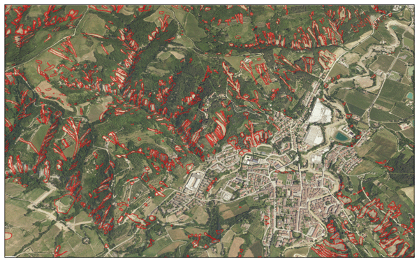
In May 2023, Emilia-Romagna, Italy, experienced heavy rainfall that led to severe flooding and initiated thousands of landslides on slopes thought to be stable. Collaborating with the Civil Protection Agency, our team created a detailed map documenting 80,997 affected areas. This comprehensive dataset is crucial for research on climate change and assists in planning and risk management by demonstrating how climate change can alter our understanding of landslide susceptibility.
Elena Ioriatti, Mauro Reguzzoni, Edoardo Reguzzoni, Andreas Schimmel, Luca Beretta, Massimo Ceriani, and Matteo Berti
Nat. Hazards Earth Syst. Sci., 25, 4941–4959, https://doi.org/10.5194/nhess-25-4941-2025, https://doi.org/10.5194/nhess-25-4941-2025, 2025
Short summary
Short summary
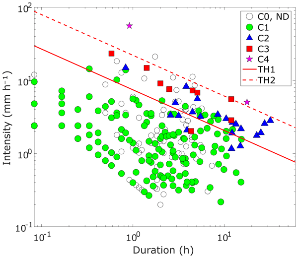
We propose a new method to define rainfall thresholds for debris flows and increased stream activity. Developed in an Alpine catchment, it relies on monitoring data and is suited to early warning in data-scarce settings with few recorded debris-flow events. The study examines sensitivity to rain-gauge placement and to the criteria used to define rainfall events.
Matteo Berti, Marco Pizziolo, Michele Scaroni, Mauro Generali, Vincenzo Critelli, Marco Mulas, Melissa Tondo, Francesco Lelli, Cecilia Fabbiani, Francesco Ronchetti, Giuseppe Ciccarese, Nicola Dal Seno, Elena Ioriatti, Rodolfo Rani, Alessandro Zuccarini, Tommaso Simonelli, and Alessandro Corsini
Earth Syst. Sci. Data, 17, 1055–1074, https://doi.org/10.5194/essd-17-1055-2025, https://doi.org/10.5194/essd-17-1055-2025, 2025
Short summary
Short summary
In May 2023, Emilia-Romagna, Italy, experienced heavy rainfall that led to severe flooding and initiated thousands of landslides on slopes thought to be stable. Collaborating with the Civil Protection Agency, our team created a detailed map documenting 80,997 affected areas. This comprehensive dataset is crucial for research on climate change and assists in planning and risk management by demonstrating how climate change can alter our understanding of landslide susceptibility.
Cited articles
Abrahams, E., Snow, T., Siegfried, M. R., and Pérez, F.: A concise tiling strategy for preserving spatial context in Earth observation imagery, arXiv [preprint], https://doi.org/10.48550/arXiv.2404.10927, 2024.
Amatya, P., Scheip, C., Déprez, A., Malet, J.-P., Slaughter, S. L., Handwerger, A. L., Emberson, R., Kirschbaum, D., Jean-Baptiste, J., Huang, M.-H., Clark, M. K., Zekkos, D., Huang, J.-R., Pacini, F., and Boissier, E.: Learnings from rapid response efforts to remotely detect landslides triggered by the August 2021 Nippes earthquake and Tropical Storm Grace in Haiti, Nat. Hazards, 118, 2337–2375, https://doi.org/10.1007/s11069-023-06096-6, 2023.
Amy, L. A. and Talling, P. J.: Anatomy of turbidites and linked debrites based on long distance (120 × 30 km) bed correlation, Marnoso Arenacea Formation, Northern Apennines, Italy, Sedimentology, 53, 161–212, https://doi.org/10.1111/j.1365-3091.2005.00756.x, 2006.
Ban, Y., Zhang, P., Nascetti, A., Bevington, A. R., and Wulder, M. A.: Near real-time wildfire progression monitoring with Sentinel-1 SAR time series and deep learning, Sci. Rep., 10, 1322, https://doi.org/10.1038/s41598-019-56967-x, 2020.
Berti, M., Pizziolo, M., Scaroni, M., Generali, M., Critelli, V., Mulas, M., Tondo, M., Lelli, F., Fabbiani, C., Ronchetti, F., Ciccarese, G., Dal Seno, N., Ioriatti, E., Rani, R., Zuccarini, A., Simonelli, T., and Corsini, A.: RER2023: the landslide inventory dataset of the May 2023 Emilia-Romagna meteorological event, Earth Syst. Sci. Data, 17, 1055–1074, https://doi.org/10.5194/essd-17-1055-2025, 2025.
Berti, M., Pizziolo, M., Scaroni, M., Generali, M., Olivucci, S., Gozza, G., Formicola, P., Critelli, V., Mulas, M., Tondo, M., Lelli, F., Fabbiani, C., Ronchetti, F., Ciccarese, G., Dal Seno, N., Ioriatti, E., Rani, R., Zuccarini, A., Simonelli, T., and Corsini, A.: Testing NDVI and U-Net for automated mapping of multiple-occurrence regional landslide events using satellite and aerial multispectral data (Casola Valsenio, Emilia-Romagna, Northern Apennines, Italy), Landslides, 23, 969–988, https://doi.org/10.1007/s10346-025-02671-z, 2026.
Blaschke, T.: Object based image analysis for remote sensing, ISPRS J. Photogramm. Remote Sens., 65, 2–16, https://doi.org/10.1016/j.isprsjprs.2009.06.004, 2010.
Brath, A., Casagli, N., Marani, M., Mercogliano, P., and Motta, R.: Rapporto della Commissione tecnico-scientifica istituita con deliberazione della Giunta Regionale n. 984/2023 e determinazione dirigenziale 14641/2023, al fine di analizzare gli eventi meteorologici estremi del mese di maggio 2023, Technical Report, Regione Emilia-Romagna, 147 pp., https://notizie.regione.emilia-romagna.it/comunicati/2023/dicembre/post-alluvione-ecco-il-rapporto-della-commissione-tecnico-scientifica-201cin-emilia-romagna-un-evento-senza-precedenti-nella-storia-osservata201d-la-vicepresidente-priolo-201cabbiamo-affrontato-qualcosa-di-difficilmente-immaginabile-uno-spartiacque-tra (last access: 26 August 2026), 2023.
Casagli, N., Cigna, F., Bianchini, S., Hölbling, D., Füreder, P., Righini, G., Del Conte, S., Friedl, B., Schneiderbauer, S., Iasio, C., Vlcko, J., Greif, V., Proske, H., Granica, K., Falco, S., Lozzi, S., Mora, O., Arnaud, A., Novali, F., and Bianchi, M.: Landslide mapping and monitoring by using radar and optical remote sensing: examples from the EC-FP7 project SAFER, Remote Sens. Appl. Soc. Environ., 4, 92–108, https://doi.org/10.1016/j.rsase.2016.07.001, 2016.
Chen, X., Liu, M., Li, D., Jia, J., Yang, A., Zheng, W., and Yin, L.: Conv-trans dual network for landslide detection of multi-channel optical remote sensing images, Front. Earth Sci., 11, 1182145, https://doi.org/10.3389/feart.2023.1182145, 2023.
Chen, Z., Zhang, Y., Ouyang, C., Zhang, F., and Ma, J.: Automated landslides detection for mountain cities using multi-temporal remote sensing imagery, Sensors, 18, 821, https://doi.org/10.3390/s18030821, 2018.
Cruden, D. M. and Varnes, D. J.: Landslide types and processes, in: Landslides: Investigation and Mitigation, edited by: Turner, A. K. and Schuster, R. L., Transportation Research Board Special Report, 247, National Academy Press, Washington, D.C., 36–75, ISBN 0-309-06151-2, 1996.
Dal Seno, N., Evangelista, D., Piccolomini, E., and Berti, M.: Comparative analysis of conventional and machine learning techniques for rainfall threshold evaluation under complex geological conditions, Landslides, 21, 2893–2911, https://doi.org/10.1007/s10346-024-02336-3, 2024.
Dosovitskiy, A., Beyer, L., Kolesnikov, A., Weissenborn, D., Zhai, X., Unterthiner, T., Dehghani, M., Minderer, M., Heigold, G., Gelly, S., Uszkoreit, J., and Houlsby, N.: An image is worth 16x16 words: transformers for image recognition at scale, arXiv [preprint], https://doi.org/10.48550/arXiv.2010.11929, 2020.
Ferrario, M. F. and Livio, F.: Rapid mapping of landslides induced by heavy rainfall in the Emilia-Romagna (Italy) region in May 2023, Remote Sens., 16, 122, https://doi.org/10.3390/rs16010122, 2024.
Foraci, R., Tesini, M. S., Nanni, S., Antolini, G., and Pavan, V.: L'inquadramento meteo e idrologico degli eventi, Ecoscienza, ARPAE Emilia-Romagna, anno XIV, 5, 20–24, https://www.arpae.it/it/ecoscienza/numeri-ecoscienza/anno-2023/numero-5-anno-2023/alluvione-emilia-romagna/foraci_et_al_es2023_5.pdf (last access: 24 August 2026), 2023.
Ghorbanzadeh, O., Blaschke, T., Gholamnia, K., Meena, S. R., Tiede, D., and Aryal, J.: Evaluation of different machine learning methods and deep-learning convolutional neural networks for landslide detection, Remote Sens., 11, 196, https://doi.org/10.3390/rs11020196, 2019.
Ghorbanzadeh, O., Crivellari, A., Ghamisi, P., Shahabi, H., and Blaschke, T.: A comprehensive transferability evaluation of U-Net and ResU-Net for landslide detection from Sentinel-2 data (case study areas from Taiwan, China, and Japan), Sci. Rep., 11, 14629, https://doi.org/10.1038/s41598-021-94190-9, 2021.
Ghorbanzadeh, O., Shahabi, H., Crivellari, A., Homayouni, S., Blaschke, T., and Ghamisi, P.: Landslide detection using deep learning and object-based image analysis, Landslides, 19, 929–939, https://doi.org/10.1007/s10346-021-01843-x, 2022a.
Ghorbanzadeh, O., Xu, Y., Ghamisi, P., Kopp, M., and Kreil, D.: Landslide4Sense: reference benchmark data and deep learning models for landslide detection, IEEE Trans. Geosci. Remote Sens., 60, 1–17, https://doi.org/10.1109/TGRS.2022.3215209, 2022b.
Ghorbanzadeh, O., Gholamnia, K., and Ghamisi, P.: The application of ResU-net and OBIA for landslide detection from multi-temporal Sentinel-2 images, Big Earth Data, 7, 961–985, https://doi.org/10.1080/20964471.2022.2031544, 2023.
Guzzetti, F., Mondini, A. C., Cardinali, M., Fiorucci, F., Santangelo, M., and Chang, K.-T.: Landslide inventory maps: new tools for an old problem, Earth-Sci. Rev., 112, 42–66, https://doi.org/10.1016/j.earscirev.2012.02.001, 2012.
Hastie, T., Tibshirani, R., and Friedman, J.: The Elements of Statistical Learning: Data Mining, Inference, and Prediction, 2nd edn., Springer, New York, NY, https://doi.org/10.1007/978-0-387-84858-7, 2009.
Hölbling, D., Eisank, C., Albrecht, F., Vecchiotti, F., Friedl, B., Weinke, E., and Kociu, A.: Comparing manual and semi-automated landslide mapping based on optical satellite images from different sensors, Geosciences, 7, 37, https://doi.org/10.3390/geosciences7020037, 2017.
Isensee, F., Jaeger, P. F., Kohl, S. A. A., Petersen, J., and Maier-Hein, K. H.: nnU-Net: a self-configuring method for deep learning-based biomedical image segmentation, Nat. Methods, 18, 203–211, https://doi.org/10.1038/s41592-020-01008-z, 2021.
Iverson, R. M., George, D. L., Allstadt, K., Reid, M. E., Collins, B. D., Vallance, J. W., Schilling, S. P., Godt, J. W., Cannon, C. M., Magirl, C. S., Baum, R. L., Coe, J. A., Schulz, W. H., and Bower, J. B.: Landslide mobility and hazards: implications of the 2014 Oso disaster, Earth Planet. Sci. Lett., 412, 197–208, https://doi.org/10.1016/j.epsl.2014.12.020, 2015.
Ji, S. P., Yu, D. W., Shen, C. Y., Li, W. L., and Xu, Q.: Landslide detection from an open satellite imagery and digital elevation model dataset using attention boosted convolutional neural networks, Landslides, 17, 1337–1352, https://doi.org/10.1007/s10346-020-01353-2, 2020.
Kingma, D. P. and Ba, J.: Adam: a method for stochastic optimization, arXiv [preprint], https://doi.org/10.48550/arXiv.1412.6980, 2017.
Kipf, T. N. and Welling, M.: Semi-supervised classification with graph convolutional networks, in: International Conference on Learning Representations (ICLR), arXiv [preprint], https://doi.org/10.48550/arXiv.1609.02907, 2017.
LeCun, Y., Bengio, Y., and Hinton, G.: Deep learning, Nature, 521, 436–444, https://doi.org/10.1038/nature14539, 2015.
Lin, T.-Y., Dollár, P., Girshick, R., He, K., Hariharan, B., and Belongie, S.: Feature Pyramid Networks for Object Detection, in: Proceedings of the IEEE Conference on Computer Vision and Pattern Recognition (CVPR), 2117–2125, arXiv [preprint], https://doi.org/10.48550/arXiv.1612.03144, 2017.
Lu, W., Hu, Y., Zhang, Z., and Cao, W.: A dual-encoder U-Net for landslide detection using Sentinel-2 and DEM data, Landslides, 20, 1975–1987, https://doi.org/10.1007/s10346-023-02089-5, 2023.
Martha, T. R., Kerle, N., Jetten, V., van Westen, C. J., and Kumar, K. V.: Characterising spectral, spatial and morphometric properties of landslides for semi-automatic detection using object-oriented methods, Geomorphology, 116, 24–36, https://doi.org/10.1016/j.geomorph.2009.10.004, 2010.
Meena, S. R., Ghorbanzadeh, O., van Westen, C. J., Nachappa, T. G., Blaschke, T., Singh, R. P., and Sarkar, R.: Rapid mapping of landslides in the Western Ghats (India) triggered by 2018 extreme monsoon rainfall using a deep learning approach, Landslides, 18, 1937–1950, https://doi.org/10.1007/s10346-020-01602-4, 2021.
Meena, S. R., Soares, L. P., Grohmann, C. H., van Westen, C., Bhuyan, K., Singh, R. P., Floris, M., and Catani, F.: Landslide detection in the Himalayas using machine learning algorithms and U-Net, Landslides, 19, 1209–1229, https://doi.org/10.1007/s10346-022-01861-3, 2022.
Meena, S. R., Nava, L., Bhuyan, K., Puliero, S., Soares, L. P., Dias, H. C., Floris, M., and Catani, F.: HR-GLDD: a globally distributed dataset using generalized deep learning (DL) for rapid landslide mapping on high-resolution (HR) satellite imagery, Earth Syst. Sci. Data, 15, 3283–3298, https://doi.org/10.5194/essd-15-3283-2023, 2023.
Mondini, A. C., Santangelo, M., Rocchetti, M., Rossetto, E., Manconi, A., and Monserrat, O.: Sentinel-1 SAR amplitude imagery for rapid landslide detection, Remote Sens., 11, 760, https://doi.org/10.3390/rs11070760, 2019.
Mondini, A. C., Guzzetti, F., Chang, K.-T., Monserrat, O., Martha, T. R., and Manconi, A.: Landslide failures detection and mapping using synthetic aperture radar: past, present and future, Earth-Sci. Rev., 216, 103574, https://doi.org/10.1016/j.earscirev.2021.103574, 2021.
Nava, L., Bhuyan, K., Meena, S. R., Monserrat, O., and Catani, F.: Rapid mapping of landslides on SAR data by Attention U-Net, Remote Sens., 14, 1449, https://doi.org/10.3390/rs14061449, 2022.
Notti, D., Cignetti, M., Godone, D., and Giordan, D.: Semi-automatic mapping of shallow landslides using free Sentinel-2 images and Google Earth Engine, Nat. Hazards Earth Syst. Sci., 23, 2625–2648, https://doi.org/10.5194/nhess-23-2625-2023, 2023.
Novellino, A., Pennington, C., Leeming, K., Taylor, S., Alvarez, I. G., McAllister, E., Arnhardt, C., and Winson, A.: Mapping landslides from space: a review, Landslides, 21, 1041–1052, https://doi.org/10.1007/s10346-024-02215-x, 2024.
Paszke, A., Gross, S., Massa, F., Lerer, A., Bradbury, J., Chanan, G., Killeen, T., Lin, Z., Gimelshein, N., Antiga, L., Desmaison, A., Köpf, A., Yang, E., DeVito, Z., Raison, M., Tejani, A., Chilamkurthy, S., Steiner, B., Fang, L., Bai, J., and Chintala, S.: PyTorch: an imperative style, high-performance deep learning library, in: Advances in Neural Information Processing Systems, 32, 8026–8037, arXiv [preprint], https://doi.org/10.48550/arXiv.1912.01703, 2019.
Pizziolo, M., Generali, M., and Scaroni, M.: In Appennino un numero di frane mai riscontrato prima, Ecoscienza, ARPAE Emilia-Romagna, anno XIV, 5, 31–33, https://ambiente.regione.emilia-romagna.it/it/geologia/divulgazione/pubblicazioni/articoli-su-riviste-specialistiche/p31_rer-frane.pdf (last access: 24 August 2026), 2023.
Pizziolo, M., Berti, M., Scaroni, M., Generali, M., Critelli, V., Mulas, M., Tondo, M., Lelli, F., Fabbiani, C., Ronchetti, F., Ciccarese, G., Dal Seno, N., Ioriatti, E., Rani, R., Zuccarini, A., Simonelli, T., and Corsini, A.: RER2023: the landslide inventory dataset of the May 2023 Emilia-Romagna event – Version 1, Zenodo [data set], https://doi.org/10.5281/zenodo.13742643, 2024.
Prakash, N. and Manconi, A.: Rapid mapping of landslides triggered by the Storm Alex, October 2020, in: 2021 IEEE International Geoscience and Remote Sensing Symposium IGARSS, Brussels, Belgium, 1808–1811, https://doi.org/10.1109/IGARSS47720.2021.9553321, 2021.
Prakash, N., Manconi, A., and Loew, S.: Mapping landslides on EO data: performance of deep learning models vs. traditional machine learning models, Remote Sens., 12, 346, https://doi.org/10.3390/rs12030346, 2020.
Prakash, N., Manconi, A., and Loew, S.: A new strategy to map landslides with a generalized convolutional neural network, Sci. Rep., 11, 9722, https://doi.org/10.1038/s41598-021-89015-8, 2021.
Prechelt, L.: Early stopping – but when?, in: Neural Networks: Tricks of the Trade, edited by: Orr, G. B. and Müller, K.-R., Springer, Berlin, Heidelberg, 55–69, https://doi.org/10.1007/3-540-49430-8_3, 1998.
Rezatofighi, H., Tsoi, N., Gwak, J., Sadeghian, A., Reid, I., and Savarese, S.: Generalized intersection over union: a metric and a loss for bounding box regression, 2019 IEEE/CVF Conference on Computer Vision and Pattern Recognition (CVPR), 658–666, https://doi.org/10.1109/CVPR.2019.00075, 2019.
Robinson, T. R., Rosser, N. J., Densmore, A. L., Williams, J. G., Kincey, M. E., Benjamin, J., and Bell, H. J. A.: Rapid post-earthquake modelling of coseismic landslide intensity and distribution for emergency response decision support, Nat. Hazards Earth Syst. Sci., 17, 1521–1540, https://doi.org/10.5194/nhess-17-1521-2017, 2017.
Ronneberger, O., Fischer, P., and Brox, T.: U-Net: convolutional networks for biomedical image segmentation, in: Medical Image Computing and Computer-Assisted Intervention – MICCAI 2015, Lecture Notes in Computer Science, 9351, 234–241, https://doi.org/10.1007/978-3-319-24574-4_28, 2015.
Sameen, M. I. and Pradhan, B.: Landslide detection using residual networks and the fusion of spectral and topographic information, IEEE Access, 7, 114363–114373, https://doi.org/10.1109/access.2019.2935761, 2019.
Scaioni, M., Longoni, L., Melillo, V., and Papini, M.: Remote sensing for landslide investigations: an overview of recent achievements and perspectives, Remote Sens., 6, 9600–9652, https://doi.org/10.3390/rs6109600, 2014.
Tang, X., Tu, Z., Wang, Y., Liu, M., Li, D., and Fan, X.: Automatic detection of coseismic landslides using a new transformer method, Remote Sens., 14, 2884, https://doi.org/10.3390/rs14122884, 2022.
Tharwat, A.: Classification assessment methods, Appl. Comput. Inform., 17, 168–192, https://doi.org/10.1016/j.aci.2018.08.003, 2020.
Tofani, V., Segoni, S., Agostini, A., Catani, F., and Casagli, N.: Technical Note: Use of remote sensing for landslide studies in Europe, Nat. Hazards Earth Syst. Sci., 13, 299–309, https://doi.org/10.5194/nhess-13-299-2013, 2013.
Tucker, C. J.: Red and photographic infrared linear combinations for monitoring vegetation, Remote Sens. Environ., 8, 127–150, https://doi.org/10.1016/0034-4257(79)90013-0, 1979.
Wasowski, J. and Bovenga, F.: Investigating landslides and unstable slopes with satellite Multi Temporal Interferometry: current issues and future perspectives, Eng. Geol., 174, 103–138, https://doi.org/10.1016/j.enggeo.2014.03.003, 2014.
Wolf, T., Debut, L., Sanh, V., Chaumond, J., Delangue, C., Moi, A., Cistac, P., Rault, T., Louf, R., Funtowicz, M., Davison, J., Shleifer, S., von Platen, P., Ma, C., Jernite, Y., Plu, J., Xu, C., Le Scao, T., Gugger, S., Drame, M., Lhoest, Q., and Rush, A. M.: Transformers: state-of-the-art natural language processing, in: Proceedings of the 2020 Conference on Empirical Methods in Natural Language Processing: System Demonstrations, 38–45, arXiv [preprint], https://doi.org/10.48550/arXiv.1910.03771, 2020.
Wu, L., Liu, R., Ju, N., Zhang, A., Gou, J., He, G., and Lei, Y.: Landslide mapping based on a hybrid CNN-transformer network and deep transfer learning using remote sensing images with topographic and spectral features, Int. J. Appl. Earth Obs. Geoinf., 126, 103612, https://doi.org/10.1016/j.jag.2023.103612, 2024.
Xie, E., Wang, W., Yu, Z., Anandkumar, A., Alvarez, J. M., and Luo, P.: SegFormer: simple and efficient design for semantic segmentation with transformers, in: Advances in Neural Information Processing Systems, 34, 12077–12090, arXiv [preprint], https://doi.org/10.48550/arXiv.2105.15203, 2021.
Xu, Y., Ouyang, C., Xu, Q., Wang, D., Zhao, B., and Luo, Y.: CAS Landslide Dataset: a large-scale and multisensor dataset for deep learning-based landslide detection, Sci. Data, 11, 12, https://doi.org/10.1038/s41597-023-02847-z, 2024.
Yang, W., Wang, Y., Sun, S., Wang, Y., and Ma, C.: Using Sentinel-2 time series to detect slope movement before the Jinsha River landslide, Landslides, 16, 1313–1324, https://doi.org/10.1007/s10346-019-01178-8, 2019.
Ye, C., Li, Y., Cui, P., Liang, L., Pirasteh, S., Marcato, J., Goncalves, W. N., and Li, J.: Landslide detection of hyperspectral remote sensing data based on deep learning with constraints, IEEE J. Sel. Top. Appl. Earth Obs. Remote Sens., 12, 5047–5060, https://doi.org/10.1109/JSTARS.2019.2951725, 2019.
Zhang, Z., Liu, Q., and Wang, Y.: Road extraction by deep residual U-Net, IEEE Geosci. Remote Sens. Lett., 15, 749–753, https://doi.org/10.1109/LGRS.2018.2802944, 2018.
Zoph, B. and Le, Q. V.: Neural architecture search with reinforcement learning, in: International Conference on Learning Representations (ICLR), arXiv [preprint], https://doi.org/10.48550/arXiv.1611.01578, 2017.
Short summary
The extreme rainfall in Emilia-Romagna in May 2023 caused over 80 000 landslides. Mapping them manually was slow and demanding, so we tested artificial intelligence to speed up this process. We applied two models in different areas using satellite and aerial images. Both produced useful maps that can guide emergency teams, although performance was lower in complex terrains. Our results show that AI can support faster disaster response in future events.
The extreme rainfall in Emilia-Romagna in May 2023 caused over 80 000 landslides. Mapping them...


Altmetrics
Final-revised paper
Preprint