
Editor(s): Michele Santangelo (National Research Council, Italy), Federica Fiorucci (National Research Council, Italy), Petra Jagodnik (University of Rijeka, Croatia), Kate Allstadt (Geologic Hazards Science Center, United States), Khamarrul Azahari Razak (University of Technology Malaysia, Malaysia), Roberto Sarro (Instituto Geológico y Minero de España, Spain), Lorenzo Nava (University of Padua, Italy), Jhonatan Steven Rivera Rivera (Universidad Politécnica de Madrid, Spain), Paola Reichenbach (National Research Council, Italy), and Andreas Günther (Federal Institute for Geosciences and Natural Resources, Germany)
27 Aug 2026
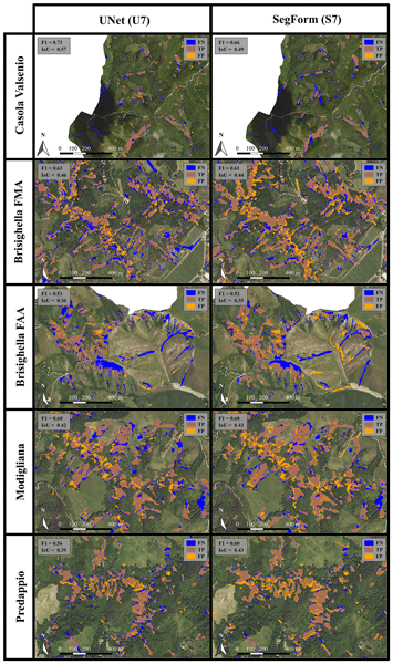
Rapid landslide mapping during the 2023 Emilia-Romagna disaster: assessing automated approaches with limited training data
Nat. Hazards Earth Syst. Sci., 26, 4101–4129, 2026

18 Aug 2026
Projecting changes in rainfall-induced landslide susceptibility across inhabited areas of China under climate change
Nat. Hazards Earth Syst. Sci., 26, 3881–3900, 2026

14 Jul 2026
Feature selection for landslide forecasting models in Southern Andes
Nat. Hazards Earth Syst. Sci., 26, 3253–3272, 2026
08 Apr 2026
Landslide susceptibility mapping with explainable AI techniques: Evidence from Bavaria, Germany
EGUsphere, 2026
Revised manuscript accepted for NHESS (discussion: final response, 8 comments)
07 Apr 2026
Linear passive source surface wave dispersion curve picking based on supervised deep learning and ambient noise tomography for the evolution of the internal structure in landslide area
EGUsphere, 2026
Revised manuscript under review for NHESS (discussion: final response, 6 comments)
16 Mar 2026
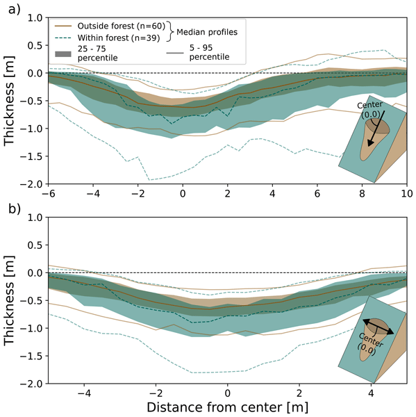
Topographic profile and morphology analysis of shallow landslides inside and outside of forests with a semi-automatic mapping approach and bi-temporal airborne laser scanning data
Nat. Hazards Earth Syst. Sci., 26, 1375–1396, 2026
05 Dec 2025
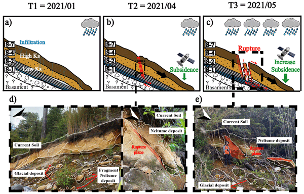
Controls over debris flow initiation in glacio-volcanic environments in the Southern Andes
Nat. Hazards Earth Syst. Sci., 25, 4843–4861, 2025
01 Dec 2025
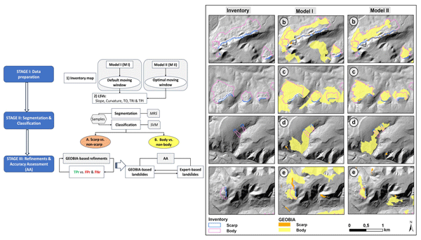
Mapping forest-covered landslides using Geographic Object-Based Image Analysis (GEOBIA), Jena region, Germany
Nat. Hazards Earth Syst. Sci., 25, 4787–4806, 2025