
Articles | Volume 26, issue 8
https://doi.org/10.5194/nhess-26-4053-2026
© Author(s) 2026. This work is distributed under
the Creative Commons Attribution 4.0 License.
the Creative Commons Attribution 4.0 License.
https://doi.org/10.5194/nhess-26-4053-2026
© Author(s) 2026. This work is distributed under
the Creative Commons Attribution 4.0 License.
the Creative Commons Attribution 4.0 License.
Research article
| 
26 Aug 2026
Research article |
| 26 Aug 2026
| 26 Aug 2026
Post-LGM intensification of marine faulting: resolution-dependent hazard assessment
Geological Survey of Israel, Yesha'yahu Leibowitz 32, Jerusalem, 9692100, Israel
Institute of Earth Sciences, The Hebrew University of Jerusalem, Jerusalem, 91904, Israel
Omri Gadol
The Hatter Department of Marine Technologies, Leon H. Charney School of Marine Sciences (CSMS), Haifa University, Mt. Carmel, Haifa, 31905, Israel
CERENA, Instituto Superior Técnico, Lisbon University, Av. Rovisco Pais, 1049-001 Lisbon, Portugal
Yizhaq Makovsky
The Hatter Department of Marine Technologies, Leon H. Charney School of Marine Sciences (CSMS), Haifa University, Mt. Carmel, Haifa, 31905, Israel
Oded Katz
Geological Survey of Israel, Yesha'yahu Leibowitz 32, Jerusalem, 9692100, Israel
Geological Survey of Israel, Yesha'yahu Leibowitz 32, Jerusalem, 9692100, Israel
Institute of Earth Sciences, The Hebrew University of Jerusalem, Jerusalem, 91904, Israel
Related authors

May Laor and Zohar Gvirtzman
Nat. Hazards Earth Syst. Sci., 23, 139–158, https://doi.org/10.5194/nhess-23-139-2023, https://doi.org/10.5194/nhess-23-139-2023, 2023
Short summary
Short summary
This study aims to provide a practical and relatively fast solution for early-stage planning of marine infrastructure that must cross a faulted zone. Instead of investing huge efforts in finding whether each specific fault meets a pre-defined criterion of activeness, we map the subsurface and determine the levels of fault hazard based on the amount of displacement and the fault's plane size. This allows for choosing the least problematic infrastructure routes at an early planning stage.
Maxim Rubin-Blum, Eyal Rahav, Guy Sisma-Ventura, Yana Yudkovski, Zoya Harbuzov, Or M. Bialik, Oded Ezra, Anneleen Foubert, Barak Herut, and Yizhaq Makovsky
Biogeosciences, 22, 1321–1340, https://doi.org/10.5194/bg-22-1321-2025, https://doi.org/10.5194/bg-22-1321-2025, 2025
Short summary
Short summary
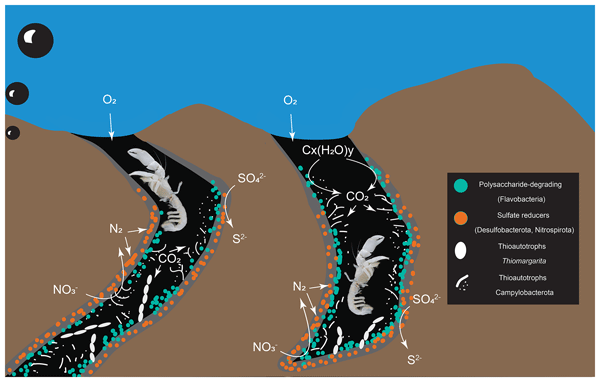
Chemotones, transition zones in chemosynthetic ecosystems, alter geochemical cycles and biodiversity. We studied seep chemotones, which are heavily burrowed by ghost shrimp. To investigate if burrowing affects habitat functionality, we surveyed the seafloor with deep-sea vehicles, analyzed sediment, and explored microbial communities in burrows. We found chemosynthetic biofilms, linking them to macromolecule turnover and nutrient cycling. This process may play a crucial role in deep-sea cycles.
Valentina Beccari, Ahuva Almogi-Labin, Daniela Basso, Giuliana Panieri, Yizhaq Makovsky, Irka Hajdas, and Silvia Spezzaferri
J. Micropalaeontol., 42, 13–29, https://doi.org/10.5194/jm-42-13-2023, https://doi.org/10.5194/jm-42-13-2023, 2023
Short summary
Short summary
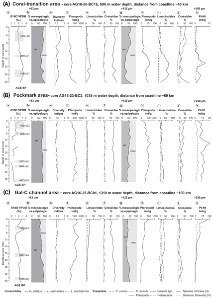
Planktonic gastropods (pteropods and heteropods) have been investigated in cores collected in the eastern Mediterranean along the Israeli coast in coral, pockmark, and channel areas. The sediment spans the last 5300 years. Our study reveals that neglecting the smaller fraction (> 63 µm) may result in a misinterpretation of the palaeoceanography. The presence of tropical and subtropical species reveals that the eastern Mediterranean acted as a refugium for these organisms.
May Laor and Zohar Gvirtzman
Nat. Hazards Earth Syst. Sci., 23, 139–158, https://doi.org/10.5194/nhess-23-139-2023, https://doi.org/10.5194/nhess-23-139-2023, 2023
Short summary
Short summary
This study aims to provide a practical and relatively fast solution for early-stage planning of marine infrastructure that must cross a faulted zone. Instead of investing huge efforts in finding whether each specific fault meets a pre-defined criterion of activeness, we map the subsurface and determine the levels of fault hazard based on the amount of displacement and the fault's plane size. This allows for choosing the least problematic infrastructure routes at an early planning stage.
Cited articles
Almagor, G., Gill, D., and Perath, I.: Marine sand resources offshore Israel, Mar. Georesour. Geotec., 18, 1–42, 2000.
Angell, M. M., Hanson, K., Swan, F. H., Youngs, R., and Abramson, H.: Probabilistic fault displacement hazard assessment for flowlines and export pipelines, Mad Dog and Atlantis field developments, deepwater Gulf of Mexico, in: Offshore technology conference, OTC–15402, https://doi.org/10.4043/15402-MS, 2003.
Ben-Avraham, Z.: The structure and tectonic setting of the Levant continental margin, Eastern Mediterranean, Tectonophysics, 46, 313–331, 1978.
Bender, B. and Perkins, D. M.: SEISRISK III: a computer program for seismic hazard estimation, US Government Printing Office, https://doi.org/10.3133/b1772, 1987.
Ben-Gai, Y., Ben-Avraham, Z., Buchbinder, B., and Kendall, C. G. S. C.: Post-Messinian evolution of the Southeastern Levant Basin based on two-dimensional stratigraphic simulation, Mar. Geol., 221, 359–379, https://doi.org/10.1016/j.margeo.2005.03.003, 2005.
Ben Zeev, Y. and Gvirtzman, Z.: When Two Salt Tectonics Systems Meet: Gliding Downslope the Levant Margin and Salt Out‐Squeezing From Under the Nile Delta, Tectonics, 1–24, https://doi.org/10.1029/2019tc005715, 2020.
Bertoni, C. and Cartwright, J. A.: Controls on the basinwide architecture of late Miocene (Messinian) evaporites on the Levant margin (Eastern Mediterranean), Sediment. Geol., 188, 93–114, 2006.
Bondevik, S., Stormo, S. K., and Skjerdal, G.: Green mosses date the Storegga tsunami to the chilliest decades of the 8.2 ka cold event, Quaternary Sci. Rev., 45, 1–6, 2012.
Brothers, D. S., Luttrell, K. M., and Chaytor, J. D.: Sea-level–induced seismicity and submarine landslide occurrence, Geology, 41, 979–982, 2013.
Bryn, P., Berg, K., Forsberg, C. F., Solheim, A., and Kvalstad, T. J.: Explaining the Storegga slide, Mar. Pet. Geol., 22, 11–19, 2005.
Buchbinder, B. and Zilberman, E.: Sequence stratigraphy of Miocene – Pliocene carbonate – Siliciclastic shelf deposits in the eastern Mediterranean margin (Israel): Effects of eustasy and tectonics, Sediment. Geol., 112, 7–32, https://doi.org/10.1016/S0037-0738(97)00034-1, 1997.
Buchbinder, B., Martinotti, G. M., Siman-Tov, R., and Zilberman, E.: Temporal and spatial relationships in Miocene reef carbonates in Israel, Palaeogeogr. Palaeocl., 101, 97–116, 1993.
Carmel, Z., Inman, D. L., and Golik, A.: Directional wave measurement at Haifa, Israel, and sediment transport along the Nile littoral cell, Coast. Eng., 9, 21–36, https://doi.org/10.1016/0378-3839(85)90025-0, 1985.
Cartwright, J., Jackson, M., Dooley, T., and Higgins, S.: Strain partitioning in gravity-driven shortening of a thick, multilayered evaporite sequence, Geological Society, London, Special Publications, https://doi.org/10.1144/sp363.21, 2012.
Cartwright, J. A. and Jackson, M. P. A.: Initiation of gravitational collapse of an evaporite basin margin: The Messinian saline giant, Levant Basin, eastern Mediterranean, Bull. Geol. Soc. Am., 120, 399–413, https://doi.org/10.1130/B26081X.1, 2008.
Catuneanu, O.: Sequence stratigraphy: Guidelines for a standard methodology, in: Stratigraphy & timescales, Vol. 2, Elsevier, 1–57, https://doi.org/10.1016/bs.sats.2017.07.003, 2017.
Catuneanu, O., Khalifa, M. A., and Wanas, H. A.: Sequence stratigraphy of the lower cenomanian bahariya formation, bahariya oasis, western desert, Egypt, Sediment. Geol., 190, 121–137, 2006.
Catuneanu, O., Galloway, W. E., Kendall, C. G. S. C., Miall, A. D., Posamentier, H. W., Strasser, A., and Tucker, M. E.: Sequence stratigraphy: methodology and nomenclature, Newsl. Stratigr., 44, 173–245, 2011.
Clark, I. R. and Cartwright, J. A.: Interactions between submarine channel systems and deformation in deepwater fold belts: Examples from the Levant Basin, Eastern Mediterranean sea, Mar. Pet. Geol., 26, 1465–1482, 2009.
Cornell, C. A.: Engineering Seismic Risk Analysis, Bull. Seismol. Soc. Am., 58, 1583–1606, https://doi.org/10.1785/BSSA0580051583, 1968.
Dugan, B. and Flemings, P. B.: Overpressure and fluid flow in the New Jersey continental slope: Implications for slope failure and cold seeps, Science, 289, 288–291, 2000.
Elfassi, Y., Gvirtzman, Z., Katz, O., and Aharonov, E.: Chronology of post-Messinian faulting along the Levant continental margin and its implications for salt tectonics, Mar. Pet. Geol., 109, 574–588, https://doi.org/10.1016/j.marpetgeo.2019.05.032, 2019.
Emerson-Paradigm: SKUA-GOCAD™ Software Suite, Emerson Paradigm Holding LLC, Houston, TX, 2022.
Emery, K. O., Neev, D., and Bentor, Y. K.: Mediterranean beaches of Israel, Geological Survey of Israel Jerusalem, Geological Survey of Israel Bulletin, 26, 1–16, 1960.
Fiorini, E., Imitazione, G., Murianni, A., Nurminen, F., Unterseh, S., and Johnson, W.: Probabilistic fault displacement hazard in a salt tectonic environment: an innovative approach, in: Offshore Site Investigation Geotechnics 9th International Conference Proceeding, SUT-OSIG. SUT, Society for Underwater Technology, 249–256, https://doi.org/10.3723/IMPG7873, 2023.
Flemings, P. B., Liu, X., and Winters, W. J.: Critical pressure and multiphase flow in Blake Ridge gas hydrates, Geology, 31, 1057–1060, 2003.
Frey-Martínez, J., Cartwright, J., and James, D.: Frontally confined versus frontally emergent submarine landslides: A 3D seismic characterisation, Mar. Pet. Geol., 23, 585–604, 2006.
Gadol, O., Tibor, G., ten Brink, U., Hall, J. K., Groves-Gidney, G., Bar-Am, G., Hübscher, C., and Makovsky, Y.: Semi-automated bathymetric spectral decomposition delineates the impact of mass wasting on the morphological evolution of the continental slope, offshore Israel, Basin Res., 32, 1156–1183, 2020.
Gadol, O., Katz, O., Kanari, M., and Makovsky, Y.: Millennial-scale phased submarine retrogressive collapse of the owl slide complex, Geomorphology, 109973, https://doi.org/10.1016/j.geomorph.2025.109973, 2025.
Galloway, W. E.: Genetic stratigraphic sequences in basin analysis II: application to northwest Gulf of Mexico Cenozoic basin, Am. Assoc. Pet. Geol. Bull., 73, 143–154, 1989.
Garfunkel, Z.: Large-scale submarine rotational slumps and growth faults in the eastern Mediterranean, Mar. Geol., 55, 305–324, 1984.
Garfunkel, Z. and Almagor, G.: Geology and structure of the continental margin off northern Israel and the adjacent part of the Levantine Basin, Mar. Geol., 62, 105–131, 1984.
Goldsmith, V. and Golik, A.: Sediment transport model of the southeastern Mediterranean coast, Mar. Geol., 37, 147–175, 1980.
Gradmann, S., Hübscher, C., Ben-Avraham, Z., Gajewski, D., and Netzeband, G.: Salt tectonics off northern Israel, Mar. Pet. Geol., 22, 597–611, https://doi.org/10.1016/j.marpetgeo.2005.02.001, 2005.
Gvirtzman, G. and Buchbinder, B.: The Late Miocene Marine Transgression in the Be'er Sheva Area, Israel J. Earth Sci., 27, 72–82, 1978.
Gvirtzman, Z., Reshef, M., Buch-Leviatan, O., and Ben-Avraham, Z.: Intense salt deformation in the Levant Basin in the middle of the Messinian Salinity Crisis, Earth Planet. Sc. Lett., 379, 108–119, 2013.
Gvirtzman, Z., Reshef, M., Buch-Leviatan, O., Groves-Gidney, G., Karcz, Z., Makovsky, Y., and Ben-Avraham, Z.: Bathymetry of the Levant basin: interaction of salt-tectonics and surficial mass movements, Mar. Geol., 360, 25–39, https://doi.org/10.1016/J.MARGEO.2014.12.001, 2015.
Gvirtzman, Z., Manzi, V., Calvo, R., Gavrieli, I., Gennari, R., Lugli, S., et al.: Intra-Messinian truncation surface in the Levant Basin explained by subaqueous dissolution, Geology, 45, 915–918, 2017.
Haflidason, H., Lien, R., Sejrup, H. P., Forsberg, C. F., and Bryn, P.: The dating and morphometry of the Storegga Slide, Mar. Pet. Geol., 22, 123–136, 2005.
Hall, J. K.: Digital shaded-relief map of Israel and environs, Agaf. ha-medidot., 1994.
Hamann, Y., Ehrmann, W., Schmiedl, G., Krüger, S., Stuut, J. B., and Kuhnt, T.: Sedimentation processes in the Eastern Mediterranean Sea during the Late Glacial and Holocene revealed by end-member modelling of the terrigenous fraction in marine sediments, Mar. Geol., 248, 97–114, https://doi.org/10.1016/j.margeo.2007.10.009, 2008.
Hamdani, I., Aharonov, E., Olive, J.-A., Parez, S., and Gvirtzman, Z.: Initiating salt tectonics by tilting: Viscous coupling between a tilted salt layer and overlying brittle sediment, J. Geophys. Res.-Sol. Ea., 126, https://doi.org/10.1029/2020JB021503, 2021.
Hamilton, E. L.: Compressional wave attenuation in marine sediments, Geophysics, 37, 620–646, https://doi.org/10.1190/1.1440287, 1972.
Hart, E. W. and Bryant, W. A.: Fault-rupture hazard zones in California: Alquist-Priolo Earthquake Fault Zoning Act with index to earthquake fault zones maps, California Department of Conservation, Division of Mines and Geology, Digital Object Identifier (DOI), 42, 38 pp., https://searchworks.stanford.edu/view/4266531 (last access: 23 August 2026), 1999.
Hough, G., Green, J., Fish, P., Mills, A., and Moore, R.: A geomorphological mapping approach for the assessment of seabed geohazards and risk, Mar. Geophys. Res., 32, 151–162, 2011.
Hsü, K. J.: Tectonic evolution of the Mediterranean basins, in: The Ocean Basins and Margins: Volume 4A The Eastern Mediterranean, Springer, 29–75, https://doi.org/10.1007/978-1-4684-3036-3_2, 1977.
Hübscher, C. and Netzeband, G. L.: Evolution of a young salt giant: the example of the Messinian evaporites in the Levantine Basin, in: The Mechanical Behavior of Salt–Understanding of THMC Processes in Salt, CRC Press, 175–182, https://doi.org/10.1201/9781315106502-20, 2017.
Hunt, D. and Tucker, M. E.: Stranded parasequences and the forced regressive wedge systems tract: deposition during base-level'fall, Sediment. Geol., 81, 1–9, 1992.
Katz, O., Reuven, E., and Aharonov, E.: Submarine landslides and fault scarps along the eastern Mediterranean Israeli continental-slope, Mar. Geol., 369, 100–115, 2015.
Klein, M., Zviely, D., Kit, E., and Shteinman, B.: Sediment Transport along the Coast of Israel: Examination of Fluorescent Sand Tracers, J. Coast. Res., 236, 1462–1470, https://doi.org/10.2112/05-0488.1, 2007.
Kvalstad, T. J.: What is the current “best practice” in offshore geohazard investigations? A State-of-the-art review, in: Offshore technology conference, OTC–18545, https://doi.org/10.4043/18545-MS, 2007.
Lafuerza, S., Sultan, N., Canals, M., Frigola, J., Berne, S., Jouet, G., Galavazi, M., and Sierro, F. J.: Overpressure within upper continental slope sediments from CPTU data, Gulf of Lion, NW Mediterranean Sea, Int. J. Earth Sci., 98, 751–768, 2009.
Laor, M. and Gvirtzman, Z.: Classifying marine faults for hazard assessment offshore Israel: a new approach based on fault size and vertical displacement, Nat. Hazards Earth Syst. Sci., 23, 139–158, https://doi.org/10.5194/nhess-23-139-2023, 2023.
Laor, M. and Gvirtzman, Z.: The role of pre-salt relief and detachment surfaces in thin-skinned tectonics: The Palmahim rapidly gliding corridor and the Dor rollover anticline, offshore Israel, Geol. Soc. Am. Bull., 138, 933–951, 2026.
Lee, Homa J.: Timing of occurrence of large submarine landslides on the Atlantic Ocean margin, Mar. Geol., 264, 53–64, 2009.
Li, W., Jing, S., Urlaub, M., and Rebesco, M.: Sea-level variations influence weak layer formation and submarine landslides on a low-latitude continental margin, Commun. Earth Environ., 6, 950, https://doi.org/10.1038/s43247-025-02949-z, 2025.
Locat, J. and Lee, H. J.: Submarine landslides: advances and challenges, Can. Geotech. J., 39, 193–212, 2002.
Loncke, L., Gaullier, V., Mascle, J., Vendeville, B., and Camera, L.: The Nile deep-sea fan: An example of interacting sedimentation, salt tectonics, and inherited subsalt paleotopographic features, Mar. Pet. Geol., 23, 297–315, https://doi.org/10.1016/j.marpetgeo.2006.01.001, 2006.
Luttrell, K. and Sandwell, D.: Ocean loading effects on stress at near shore plate boundary fault systems, J. Geophys. Res.-Sol. Ea., 115, https://doi.org/10.1029/2009JB006541, 2010.
Manzi, V., Gennari, R., Lugli, S., Persico, D., Reghizzi, M., Roveri, M., Schreiber, B.C., Calvo, R., Gavrieli, I., and Gvirtzman, Z.: The onset of the Messinian salinity crisis in the deep Eastern Mediterranean basin, Terra Nova, 30, 189–198, 2018.
Mart, Y. and Gai, Y. B.: Some depositional patterns at continental margin of southeastern Mediterranean Sea, Am. Assoc. Petrol. Geol. Bull., 66, 460–470, https://doi.org/10.1306/03b59b39-16d1-11d7-8645000102c1865d, 1982.
Mart, Y. and Ryan, W.: The levant slumps and the Phoenician structures: Collapse features along the continental margin of the southeastern Mediterranean Sea, Mar. Geophys. Res., 28, 297–307, https://doi.org/10.1007/s11001-007-9032-7, 2007.
Martinez, J. F., Cartwright, J., and Hall, B.: 3D seismic interpretation of slump complexes: Examples from the continental margin of Israel, Basin Res., 17, 83–108, https://doi.org/10.1111/j.1365-2117.2005.00255.x, 2005.
Maslin, M., Owen, M., Day, S., and Long, D.: Linking continental-slope failures and climate change: Testing the clathrate gun hypothesis, Geology, 32, 53–56, 2004.
Masson, D. G., Harbitz, C. B., Wynn, R. B., Pedersen, G., and Løvholt, F.: Submarine landslides: processes, triggers and hazard prediction, Philos. Trans. Roy. Soc. A, 364, 2009–2039, 2006.
McGuire, R. K.: FORTRAN computer program for seismic risk analysis, https://doi.org/10.3133/ofr7667, 1976.
Meilijson, A., Steinberg, J., Hilgen, F., Bialik, O. M., Waldmann, N. D., and Makovsky, Y.: Deep-basin evidence resolves a 50-year-old debate and demonstrates synchronous onset of Messinian evaporite deposition in a non-desiccated Mediterranean, Geology, 46, 243–246, 2018.
Mitrovica, J. X. and Peltier, W. R.: On postglacial geoid subsidence over the equatorial oceans, J. Geophys. Res.-Sol. Ea., 96, 20053–20071, 1991.
Moneron, J. and Gvirtzman, Z.: Multiphase deformation of a multilayered salt giant: Salt tectonics in the Levant Basin, Geol. Soc. Am. Bull., 137, 4919–4937, 2025.
Neev, D., Almagor, G., Arad, A., Ginzburg, A., and Hall, J. K.: The geology of the Southeastern Mediterranean Sea, GSI Report, 1–88, https://www.researchgate.net/publication/287456670_The_geology_of_the_southeastern_Mediterranean (last access: 23 August 2026), 1976.
Netzeband, G. L., Hübscher, C. P., and Gajewski, D.: The structural evolution of the Messinian evaporites in the Levantine Basin, Mar. Geol., 230, 249–273, https://doi.org/10.1016/J.MARGEO.2006.05.004, 2006.
On, G. N.: Guidance Notes on Subsea Pipeline Route Determination, American Bureau of Shipping, https://ww2.eagle.org/en/news/press-room/ (last access: 23 August 2026), 2016.
Owen, M., Day, S. and Maslin, M.: Late Pleistocene submarine mass movements: occurrence and causes, Quaternary Sci. Rev., 26, 958–978, 2007.
Paull, C. K., Buelow, W. J., Ussler III, W., and Borowski, W. S.: Increased continental-margin slumping frequency during sea-level lowstands above gas hydrate–bearing sediments, Geology, 24, 143–146, 1996.
Plint, A. G.: Sharp-based shoreface sequences and “offshore bars” in the Cardium Formation of Alberta: their relationship to relative changes in sea level, https://doi.org/10.2110/pec.88.01.0357, 1988.
Posamentier, H. W. and Allen, G. P.: Siliciclastic sequence stratigraphy, Concepts and Applications: SEPM, Concept. Sediment. P., 7, 210, https://doi.org/10.2110/csp.99.07, 1999.
Posamentier, H. W., Allen, G. P., James, D. P., and Tesson, M.: Forced regressions in a sequence stratigraphic framework: concepts, examples, and exploration significance, Am. Assoc. Pet. Geol. Bull., 76, 1687–1709, 1992.
Prior, D. B. and Hooper, J. R.: Sea floor engineering geomorphology: Recent achievements and future directions, Geomorphology, 31, 411–439, https://doi.org/10.1016/S0169-555X(99)00090-2, 1999.
Rowan, M. G., Jackson, M. P. A., and Trudgill, B. D.: Salt-related fault families and fault welds in the northern Gulf of Mexico, Am. Assoc. Pet. Geol. Bull., 83, 1454–1484, https://doi.org/10.1306/e4fd41e3-1732-11d7-8645000102c1865d, 1999.
Ryan, W. B. F.: Decoding the mediterranean salinity crisis, Sedimentology, 56, 95–136, https://doi.org/10.1111/j.1365-3091.2008.01031.x, 2009.
Sagy, Y., Gvirtzman, Z., Reshef, M., and Makovsky, Y.: The enigma of the Jonah high in the middle of the Levant basin and its significance to the history of rifting, Tectonophysics, 665, 186–198, 2015.
Sagy, Y., Dror, O., Gardosh, M., and Reshef, M.: The origin of the Pliocene to recent succession in the Levant basin and its depositional pattern, new insight on source to sink system, Mar. Pet. Geol., 120, 104540, https://doi.org/10.1016/j.marpetgeo.2020.104540, 2020.
Sammartini, M., Camerlenghi, A., Budillon, F., Insinga, D. D., Zgur, F., Conforti, A., Iorio, M., Romeo, R., and Tonielli, R.: Open-slope, translational submarine landslide in a tectonically active volcanic continental margin (Licosa submarine landslide, southern Tyrrhenian Sea), Geological Society, London, Special Publications, 477, 133–150, https://doi.org/10.1144/SP477.34, 2019.
Schattner, U. and Lazar, M.: Hierarchy of source-to-sink systems – Example from the Nile distribution across the eastern Mediterranean, Sediment. Geol., 343, 119–131, https://doi.org/10.1016/j.sedgeo.2016.08.006, 2016.
Schattner, U., Lazar, M., Tibor, G., Ben-Avraham, Z., and Makovsky, Y.: Filling up the shelf – A sedimentary response to the last post-glacial sea rise, Mar. Geol., 278, 165–176, https://doi.org/10.1016/j.margeo.2010.10.006, 2010.
Schattner, U., Lazar, M., Harari, D., and Waldmann, N.: Active gas migration systems offshore northern Israel, first evidence from seafloor and subsurface data, Cont. Shelf Res., 48, 167–172, https://doi.org/10.1016/j.csr.2012.08.003, 2012.
Schattner, U., Gurevich, M., Kanari, M., and Lazar, M.: Levant jet system-effect of post LGM seafloor currents on Nile sediment transport in the eastern Mediterranean, Sediment. Geol., 329, 28–39, https://doi.org/10.1016/j.sedgeo.2015.09.007, 2015.
Schattner, U., Lang, G., and Lazar, M.: Pliocene or Pleistocene, That Is the Question – New Constraints from the Eastern Mediterranean, Quaternary of the Levant, 63–74, https://doi.org/10.1017/9781316106754.007, 2017.
Sclater, J. G. and Christie, P. A. F.: Continental stretching: An explanation of the post-mid-Cretaceous subsidence of the central North Sea basin, J. Geophys. Res.-Sol. Ea., 85, 3711–3739, 1980.
Segev, A., Rybakov, M., Lyakhovsky, V., Hofstetter, A., Tibor, G., Goldshmidt, V., and Avraham, Z. B.: The structure, isostasy and gravity field of the Levant continental margin and the southeast Mediterranean area, Tectonophysics, 425, 137–157, 2006.
Sheriff, R. E. and Geldart, L. P.: Exploration seismology, Cambridge University Press, https://doi.org/10.1017/CBO9781139168359, 1995.
Sloss, L. L., Krumbein, W. C., and Dapples, E. C.: Integrated facies analysis, https://doi.org/10.1130/MEM39-p91, 1949.
Smith, D. E., Harrison, S., and Jordan, J. T.: Sea level rise and submarine mass failures on open continental margins, Quaternary Sci. Rev., 82, 93–103, 2013.
Steinberg, J., Gvirtzman, Z., Folkman, Y., and Garfunkel, Z.: Origin and nature of the rapid late Tertiary filling of the Levant Basin, Geology, 39, 355–358, 2011.
Sultan, N., Cochonat, P., Canals, M., Cattaneo, A., Dennielou, B., Haflidason, H., Laberg, J. S., Long, D., Mienert, J., Trincardi, F., and others: Triggering mechanisms of slope instability processes and sediment failures on continental margins: a geotechnical approach, Mar. Geol., 213, 291–321, 2004.
Tappin, D. R.: Digital elevation models in the marine domain: investigating the offshore tsunami hazard from submarine landslides, Geological Society, London, Special Publications, 345, 81–101, https://doi.org/10.1144/SP345.10, 2010.
Tibor, G., Ben-Avraham, Z., Steckler, M., and Fligelman, H.: Late Tertiary subsidence history of the southern Levant Margin, eastern Mediterranean Sea, and its implications to the understanding of the Messinian Event, J. Geophys. Res., 97, 17593, https://doi.org/10.1029/92JB00978, 1992.
Trincardi, F., Cattaneo, A., Correggiari, A., Mongardi, S., Breda, A., and Asioli, A.: Submarine Slides During Relative Sea Level Rise: Two Examples from the Eastern Tyrrhenian Margin, in: Submarine Mass Movements and Their Consequences, edited by: Locat, J., Mienert, J., and Boisvert, L., Advances in Natural and Technological Hazards Research, Springer, Dordrecht, 19, 469–478, https://doi.org/10.1007/978-94-010-0093-2_52, 2003.
Urlaub, M., Talling, P. J., and Masson, D. G.: Timing and frequency of large submarine landslides: Implications for understanding triggers and future geohazard, Quaternary Sci. Rev., 72, 63–82, https://doi.org/10.1016/J.QUASCIREV.2013.04.020, 2013.
Vail, P. R., Mitchum Jr., R. M., Todd, R. G., Widmier, J. M., Thompson III., S., Sangree, J. B., Bubb, J. N., and Hatlelid, W. G.: Seismic Stratigraphy and Global Changes of Sea Level, in: Seismic Stratigraphy – Applications to Hydrocarbon Exploration, edited by: Payton, C. E., Vol. 26, American Association of Petroleum Geology Memoir, Tulsa, 49–212, https://doi.org/10.1306/M26490C7, 1977.
Waelbroeck, C., Labeyrie, L., Michel, E., Duplessy, J. C., McManus, J. F., Lambeck, K., Balbon, E., and Labracherie, M.: Sea-level and deep water temperature changes derived from benthic foraminifera isotopic records, Quaternary Sci. Rev., 21, 295–305, https://doi.org/10.1016/S0277-3791(01)00101-9, 2002.
Wien, K., Holz, C., Kölling, M., and Schulz, H. D.: Age models for pelagites and turbidites from the Cap Timiris Canyon off Mauritania, Mar. Pet. Geol., 23, 337–352, 2006.
Wong, I. G. and Stepp, C.: Probabilistic seismic hazard analyses for fault displacement and vibratory ground motion at Yucca Mountain, Nevada, Milestone SP32IM3, September, 23, https://doi.org/10.1193/1.1586169, 1998.
Youngs, R., Arabasz, W., Anderson, R., Ramelli, A., Ake, J., Slemmons, D., McCalpin, J., Doser, D. I., Fridrich, C. J., Swan, F.H., Rogers, A. M., Yount, J. C., Anderson, L. W., Smith, K., Bruhn, R., Knuepfer, P., Smith, R. B., DePolo, C., O'Leary, D. W., Coppersmith, K., Pezzopane, S., Schwartz, D. P., Whitney, J., Olig, S., and Toro, G.: A methodology for probabilistic fault displacement hazard analysis (PFDHA), Earthq. Spectra, 19, 191–219, 2003.
Zucker, E., Gvirtzman, Z., Steinberg, J., and Enzel, Y.: Salt tectonics in the Eastern Mediterranean Sea: Where a giant delta meets a salt giant, Geology, 48, 134–138, 2020.
Zucker, E., Gvirtzman, Z., Granjeon, D., and Garcia-castellanos, D.: The accretion of the Levant continental shelf alongside the Nile Delta by immense margin-parallel sediment transport, Mar. Pet. Geol., 126, 104876, https://doi.org/10.1016/j.marpetgeo.2020.104876, 2021.
Zviely, D., Sivan, D., Ecker, A., Bakler, N., Rohrlich, V., Galili, E., Boaretto, E., Klein, M., and Kit, E.: Holocene evolution of the Haifa Bay area, Israel, and its influence on ancient tell settlements, Holocene, 16, 849–861, https://doi.org/10.1191/0959683606hol977rp, 2006.
Zviely, D., Kit, E., and Klein, M.: Longshore sand transport estimates along the Mediterranean coast of Israel in the Holocene, Mar. Geol., 238, 61–73, 2007.
Short summary
A sub-meter high-resolution multi-channel seismic imaging offshore Israel reveals that marine fault slip rates are significantly higher than previously assumed. Our records suggest repeated accelerations correlated with glacial-interglacial transitions, indicating significant slip episodes that actively reshape the seafloor. As these events remained undetected in lower-resolution surveys, current methodologies likely underestimate the seismic hazards posed to marine infrastructure.
A sub-meter high-resolution multi-channel seismic imaging offshore Israel reveals that marine...


Altmetrics
Final-revised paper
Preprint