
the Creative Commons Attribution 4.0 License.
the Creative Commons Attribution 4.0 License.
 | 26 Aug 2026
Brief communication: Towards defining the worst-case breach scenarios and potential flood volumes for moraine-dammed lake outbursts
Adam Emmer
Ashim Sattar
Jan Hrebrina
Moraine dam failures are the main source of catastrophic glacial lake outburst floods (GLOFs). The effective GLOF disaster risk management requires reliable identification of areas at risk. While predictive outburst flood modelling benefits from advancing tools and computational capacities, some of the fundamental considerations remain poorly addressed. Among them, the outburst flood scenarios are essential yet often oversimplified input for modelling. Here we present novel methodology which enables the estimation of a maximum breach depth and so the calculation of potential flood volume (PFV) in geotechnical data-scarce regions, with the key parameter being the slope of the breached channel (α) derived from past events.
- Article
(1025 KB) - Full-text XML
-
Supplement
(578 KB) - BibTeX
- EndNote


Catastrophic outbursts of moraine-dammed lakes are the major concern in high mountain regions across the globe (Emmer, 2024). The effective GLOF disaster risk management calls for the identification of GLOF hazard zones, which is typically achieved through predictive GLOF modelling which – among other inputs – requires lake volume estimates and potential flood volume scenarios. While methodologies for the estimation of a glacial lake volume progressed substantially in recent years (e.g., Bazai et al., 2024; Gantayat et al., 2024; Qi et al., 2025), the way the PFV scenarios are defined often neglects elementary parameters including moraine dam geometry and the tendency to disregard moraine dam geometry when defining GLOF scenarios is observed even in otherwise state-of-the-art GLOF risk assessment studies (e.g., Furian and Sauter, 2025).
At the same time, the systematic analysis of past GLOFs suggest that large moraine-dammed lakes typically do not drain completely during the GLOF and that the breached channels are typically not flat (e.g., Emmer et al., 2022; Lützow et al., 2023). As a result, the breach scenarios that do not take into account moraine dam geometry may be overestimated and the worst-case scenarios (WCS) assuming complete lake drainage may be unrealistic in certain dam geometry/bedrock overdeepening settings. Following the study of Fujita et al. (2013) who used the 10° distal slope threshold, this short comment aims at presenting a simple method for the estimation of a maximum breach depth and so the calculation of the PFV of the WCS, building on the quantitative analysis of post-GLOF geometries of outflow channels through breached moraine dams.
Using the most updated version (v 4.1) of the global GLOF database (Lützow et al., 2023) available from glofs.geoecology.uni-potsdam.de as well as regional databases and source papers (see Table S1 in the Supplement), we searched for and compiled the list of relevant GLOF events which met following criteria:
-
Lake dam type. Moraine (all other lake dam types as well as not classified dams were not considered)
-
Outburst mechanism. Moraine dam breach (overtopping, piping, tunneling and other specific mechanisms were excluded)
-
Outburst volume. 1 000 000 m3 or more (small events and events with unknown outburst volume were excluded)
-
Available data and other considerations. Only cases with available post-GLOF DEM were considered; cases where the breached channel could not be localized in remote sensing images were removed; cases with major anthropogenic modification of a breached channel were removed
Our final list of relevant events composes of 26 GLOFs meeting the criteria (see Table S1). Out of these, 14 (53.8 %) are located in High Mountain Asia, followed by 9 cases from the Andes (34.6 %; including tropical (n=5) as well as Patagonian (n=4)) and remaining 3 cases (12.5 %) from Canadian Coast Mountains.
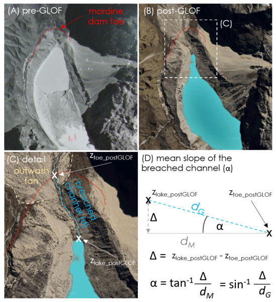
The post-GLOF lake level elevation (zlake_postGLOF) and elevation of the stream at the toe (typically lowermost point) of the breached moraine dam (ztoe_postGLOF) were measured in QGIS using 12.5 m Advanced Land Observing Satellite Digital Elevation Model (ALOS PALSAR DEM available from NASA Earthdata platform) for which the data were acquired between 2008 and 2011, Canadian Digital Elevation Model (CDEM) or 30 m Shuttle Radar Topography Mission (SRTM) digital elevation model hosted by Google Earth (https://earth.google.com/, last access: June 2026). In addition, the length of the breached channel (d) was measured between the lake and the toe of the breached moraine dam (see Fig. 1) from high resolution ESRI and Google satellite images connected to QGIS as XYZ tiles. The post-GLOF mean slope steepness of the breached channel (α) was then calculated using basic trigonometric function:
where α is the mean slope of the breached channel (in °), zlake_postGLOF is the elevation of post-GLOF lake water level (m a.s.l.), ztoe_postGLOF is the elevation of the toe of the breached moraine dam (in m a.s.l.) and d is the length of the breached channel (in m). Depending on whether the map length (dM) or ground length (dG) is measured, tan or sin trigonometric function is used in the calculation. The list of analyzed GLOFs with their characteristics is presented in Table S1 in the Supplement.
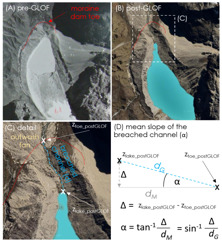
Figure 1Methodology used for the estimation of the mean slope of the breached channel (α) exemplified by Jancarurish lake, Cordillera Blanca, Peru, which experienced and outburst in 1950. (A) shows the situation before the outburst with delineated toe of moraine dam; (B) shows post-GLOF image of the same area; (C) shows detail of breached moraine dam and (D) shows the methodology of calculating the mean slope of the breached channel. Background images: (A) a segment of an aerial image from the archive of Autoridad Nacional del Agua (ANA) in Huaraz, Peru; (B) and (C) ESRI XYZ tile collection (© Esri | Powered by Esri).
3.1 Observed limits of dam breaching
We found rather narrow range of the mean slope of the breached channels of 26 major GLOFs worldwide (see Fig. S1 in the Supplement). It ranges from 2.3° (South Lhonak lake; Nostetuko lake) to 19.5° (Zhangzangbo lake) while the median is 4.9° and mean is 5.4°. One half of breached channels (Q1 to Q3) have mean slopes between 3.0° to 6.5°. We also observed regional differences: while the mean and median slope of the breached channels is 5.7°, respectively 4.5°, in HMA, these values are increased to 6.8°, respectively 6.9°, in Peruvian Andes, and decreased to 3.1°, respectively 3.5°, in Patagonian Andes. The lowest values of the mean slope of the breached channel are observed in Coastal Mountains with Nostetuko (2.3°) and Queen Bess Lake (2.8°). We found no correlation between the flood volume and the mean slope of the breached channel, as well as between the mean slope of the breached channel and its length (see Fig. S1), suggesting that these thresholds of the slope of the breached channel are independent and thus applicable to predicting outbursts of different magnitudes and dam geometries. Similarly, there is no correlation between the elevation of the lake and the slope of the breached channel, although the breached channels in lower elevation regions (Patagonia, Coast Mountains) tend to be flatter (lower topographic potential).
3.2 Geometric approximation of maximum breach depth and flood volume
The minimum mean slope of the breached channel (α) derived from past moraine dam failures (Table S1) allows for the calculation of maximum breach depth (hb) and potential flood volume (PFV; see Fig. 2). Maximum breach depth (hb) is calculated as follows:
where hb is maximum breach depth (max. lake level drop, in m), zlake_preGLOF is the elevation of the lake water level before the GLOF (m a.s.l.); zToe is the minimum elevation of the moraine toe (in m a.s.l.), d is the map length of the breached channel measured from the toe of the moraine dam to the lake (in m) and α is the selected value of the mean slope of the breached channel (in °). Depending on whether the map length (dM) or ground length (dG) is measured, tan or sin trigonometric function is used. Potential flood volume (PFV) can then be calculated as follows:
where PFA is potential flood volume (in m3), hb is maximum breach depth (lake level drop; in m) and A is lake area (in m2).
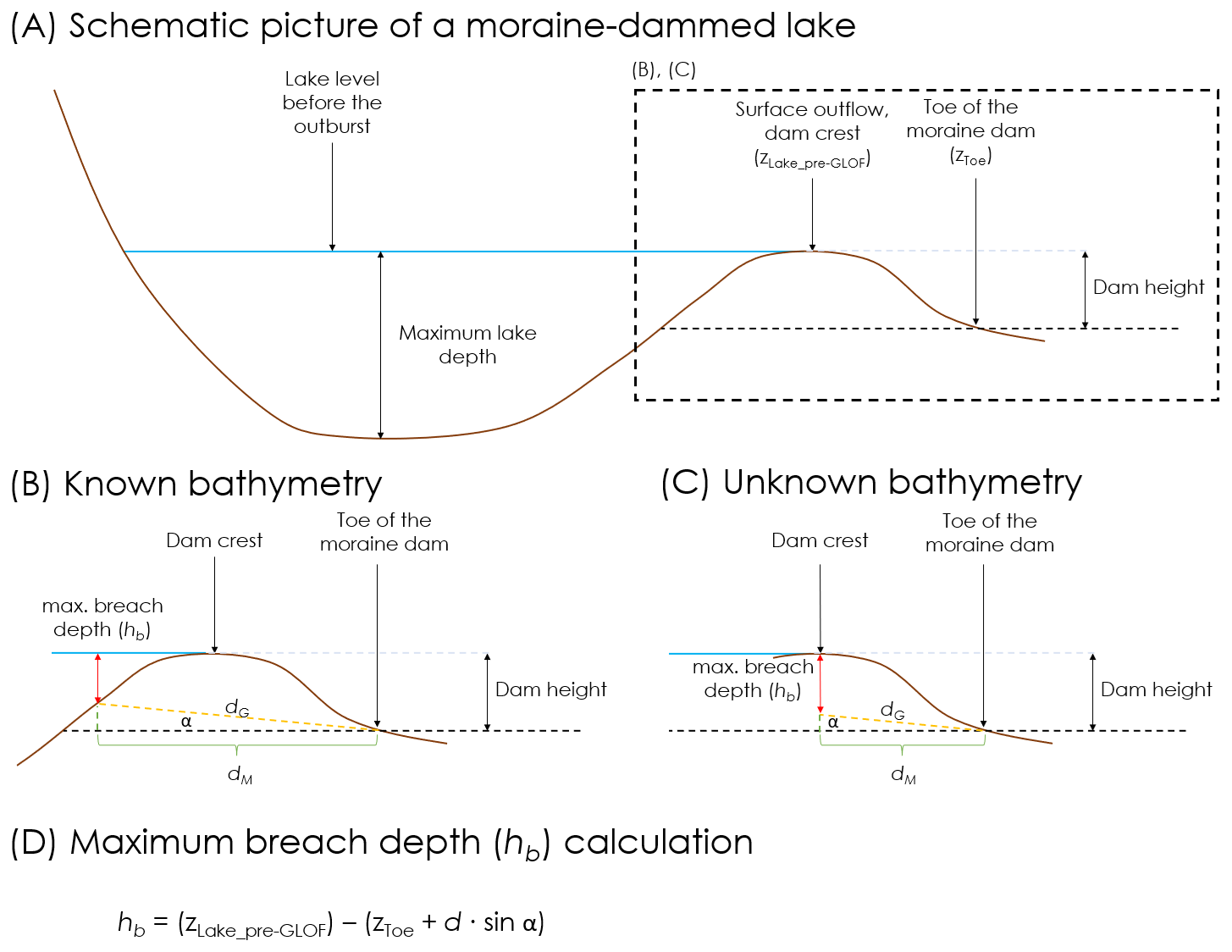
Figure 2Estimating max. breach depth of a moraine-dammed lake. (A) shows a schematic picture of a moraine-dammed lake with key terms. (B) shows how maximum breach depth is estimated for lakes with known bathymetry and (C) shows how maximum breach depth is estimated for lakes with unknown bathymetry.
3.3 Potential flood volume and released volume of selected lakes
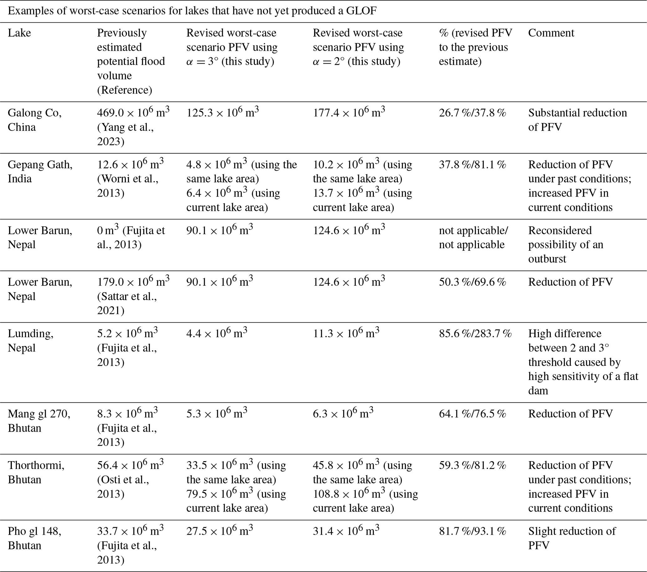
We compared selected examples of published worst-case glacial lake outburst floods scenarios with revised PFV estimates using presented method with α=3° (75th percentile) and α=2° (slightly below the lowest observed values), revealing that the new method tends to provide rather modest estimates (Table 1). The results indicate that the new method exhibits reduced PFV for lakes with flat wide dams (such as Galong Co), while it tend to provide comparable results to previous estimates in case of narrow and high dams with steeper outflow channels (e.g. Pho gl 148).
Table 1The comparison of selected worst-case scenario PFV derived from the literature with the estimates obtained with the new method (see Table S2 for the input data).
4.1 Reconsidering the “worst-case GLOF scenario”
The “worst-case scenario” of a GLOF is frequently defined as 100 % of a lake water release (e.g., Allen et al., 2022). However, available literature suggests that a complete moraine-dammed lake emptying due to a GLOF is rather rare process and there are several reasons why moraine dam breaches typically do not lead to complete lake emptying. For instance, Emmer et al. (2022) found that less than 10 % of cases experienced complete lake emptying, all of which were small and rather shallow lakes (where dam height > maximum lake depth). We argue that a complete lake emptying is in many cases not realistic considering often overdeepened nature of glacial lake basins with increasing lake depth towards the glacier, as well as lithological (grain size distribution of moraine material, presence of not-erodible layers, protruding bedrock) and physical limits of breach development.
Field observations and laboratory studies of overtopping failures in homogeneous embankments (Frank, 2016) show that breach incision typically migrates upstream from the downstream face, lowering the breach invert until it approaches the lowest continuous slope toward the downstream toe (Halso, 2024). This is because once erosion reaches the toe elevation, further vertical incision is constrained by the downstream valley grade, and hydraulic energy is dissipated mainly through lateral widening. Moraine dams, despite their heterogeneous composition, often behave similarly during breaching processes: erosion proceeds retrogressively until it intersects the lowest outlet control, which is frequently at or near the toe. The stabilization of the channel at angle α is fundamentally driven by the moraine material, density of buried large clasts and the reduction in hydraulic head. When the head is sufficiently high, it generates large discharges that create driving forces exceeding the resistance of the moraine material. During this phase, the flow entrains fine sediment, leaving behind only the coarse clasts significantly increasing the channel's roughness and its resistance to further erosion.
By representing the breach channel as a straight slope from the lake margin to the toe, the maximum breach depth (hb) can be estimated directly from the post-GLOF lake level, the toe elevation, and the channel slope, providing a simple way to derive potential flood volume and, subsequently, peak discharge estimates. This approach assumes that (i) erosion is not arrested prematurely by resistant material (e.g., ice cores, buried boulders, clay beds or bedrock), (ii) the toe elevation (ztoe) is correctly identified as the true lowest breach control point, and (iii) there is sufficient hydraulic head and duration for the breach to incise to this level. Where these conditions are not met, hb should be treated as an upper bound, and site-specific corrections may be needed.
These reasons combined with insights from past GLOFs, we find complete lake emptying of a large moraine-dammed lake rather unlikely and we offer a simple methodology for designing the worst-case scenario by estimating maximum breach depth (hb) and PFV.
4.2 Lessons for GLOF modelling: moraine dam geometry and outflow location matter
Predictive GLOF hazard and risk assessments typically rely on scenario-based modeling, where potential outburst events are defined using breach parameters such as breach depth, width, and formation time. In empirically calculated breach, parameters including the breach width and breach formation time are a function of the breach depth (Froehlich, 1995). These parameters critically influence the shape and magnitude of the resulting hydrographs, particularly peak discharge and total flood volume. The ∼40 % reduction in the breach depth can increase time of failure by ∼33 % and decrease breach width by ∼16 % (Sattar et al., 2021). However, in the absence of standardized procedure to determine the WCS, these GLOF scenarios are often modeled under the assumption of complete lake drainage.
This approach can significantly overestimate downstream hazard, particularly in cases where the maximum lake depth exceeds the dam height, which is common in large moraine-dammed lakes formed in overdeepened glacial basins. Another key factor influencing GLOF magnitude is the breach location. A breach forming at the lowest point of the moraine toe is more likely to result in a deeper incision and thus a larger volume of water released. This was evident in the 2023 South Lhonak Lake GLOF event, where the breach occurred toward the orographic left of the moraine, rather than at its lowest elevation. This constrained the incision depth and resulted in partial drainage of the lake – approximately 50 % of the lake volume remained. If the lake would have had the breach formed at the lowest point of the moraine toe, it is likely that a deeper incision would have occurred, leading to a larger volume of water release in the GLOF event.
In addition, from a modeling perspective, assuming full drainage of a glacial lake can lead to substantial overestimation of key flood parameters such as flow depth, velocity, and inundation extent. Modeling the outflow based on the full lake volume – without considering these physical constraints – can produce unrealistic scenarios that exaggerate downstream hazard. For instance, GLOF arrival time is highly dependent on the breach depth, which significantly influences the flood dynamics and consequently the GLOF lead-time (Sattar et al., 2021). The breach depth governs the rate at which water is released from the lake, with deeper breaches typically resulting in a more rapid outflow, thereby reducing the available warning time for downstream areas. Conversely, a shallower breach would generally result in a slower discharge. Thus, accurately quantifying breach depth is crucial for the reliability of GLOF prediction models.
The breach depth is typically limited by the dam height and the topography of the outflow zone and a more realistic estimate of maximum breach depth allows for the development of better-constrained WCS. These observations underscore the importance of carefully defining breach scenarios based not only on breach dimensions, but also on dam geometry and topography as well as outflow (potential breach) location not necessarily located at the center of the moraine. Accounting for these factors is essential to avoid overestimation of GLOF hazard in scenario-based modeling, particularly for the WCS GLOF assessments.
4.3 Remaining challenges and limitations
While the slope of the breach channel (α) and so the breach depth (hb) directly control the potential flood volume, they only indirectly control the outburst flood peak discharge – a key characteristic of a flood in hazard zonation and disaster risk assessments. The peak discharge is a function of the timing of breach development (how fast the breach develops) and its cross-profile shape and area (how much water can go through it). Only limited amount of literature addresses these highly uncertain inputs, generally assuming that large (>30 m deep) moraine dam breaches develop within tens of minutes to few hours; i.e., assuming incision rates up to 2 m min−1 (Froehlich, 1995, 2025).
The remaining uncertainties related to the proposed method concern primarily two questions:
-
Can breached channels be flattened below the observed thresholds derived from documented cases? Although unlikely, we cannot exclude the possibility of a GLOF magnitude beyond observations. In such cases, the outflow channel erosion could possibly go beyond the thresholds of α=2°. Therefore, we recommend not using proposed method for flood magnitudes exceeding those in the dataset (i.e., flood volumes in magnitude of 108 m3 and peak discharge in magnitude of 104 m3 s−1) as well as for physical geographical conditions (topography, geomorphology, geology, etc.) fundamentally differing from those in the analyzed dataset.
-
Can the valley floor material beneath the actual moraine dam be eroded too during a GLOF? Our observation suggests that in moraine-dam breaches, incision rarely continues below the toe of the dam because the toe sets the hydraulic control for lake drainage, and once reached, the flow energy shifts from vertical cutting to lateral widening. Therefore, the toe of the moraine usually experiences the deposition of material eroded from the dam during the outburst (see the example of lake Jancarurish in Fig. 1). The exception with clear erosion below the elevation of the point where the stream leaves the dam is the South Lhonak lake outburst. The dam breach was followed by channel incision directly downstream the dam (Sattar et al., 2025), which could be explained by the direction of the outflow channel towards topographically narrow side of the valley (so the energy of the flow is not dissipated) and the presence of erodible colluvial material.
4.4 Concluding remarks
We analyzed the slope of the breach channels of world's largest outbursts from moraine-dammed lakes (outburst volume reportedly exceeding 106 m3 in each case). Our analysis suggests that regardless the total flood volume (differing in order of two magnitudes in the dataset; from 106 to 108 m3) and peak discharges allegedly exceeding 104 m3 s−1, the incision of the outflow channel stops when it is flattened to a certain slope steepness (minimum observed steepness is 2.3°, median is 4.9°). These values are substantially lower than the 10° threshold previously proposed by Fujita et al. (2013). Our observation has two important implications for developing PFV scenarios:
-
Using the mean slope steepness of the breached channel α represents a simple way of estimating the worst-case scenario breach depths and potential flood volumes for moraine dam failure-induced lake outbursts (with both known and unknown bathymetries);
-
This threshold also suggests that existing outflow channels with the mean steepness α<3° are unlikely to be breached, while these lakes can still be prone to dam overtopping-induced floods.
We employed our new method to recalculate previously estimated worst-case scenario potential flood volumes, revealing that it tends to provide modest results. This fine-tuning of moraine dam breach GLOF scenarios has clear implications for predictive modelling and so definition of GLOF exposed areas and hazard zones in regions where the lack of geotechnical and bathymetrical data does not allow for high fidelity dam breach and flood propagation modelling.
The data analysed in this study (remote sensing data, climate reanalysis data) are freely available (see details in the main text). Any additional information will be provided by the corresponding author upon request.
The supplement related to this article is available online at https://doi.org/10.5194/nhess-26-4045-2026-supplement.
AE developed research idea and analysed remote sensing data, AS and JH contributed to the discussion of research design and text production. In particular, AS elaborated parts related to GLOF modelling and JH elaborated parts dealing with physical controls of breach development.
The contact author has declared that none of the authors has any competing interests.
Publisher's note: Copernicus Publications remains neutral with regard to jurisdictional claims made in the text, published maps, institutional affiliations, or any other geographical representation in this paper. The authors bear the ultimate responsibility for providing appropriate place names. Views expressed in the text are those of the authors and do not necessarily reflect the views of the publisher.
We thank Koji Fujita and two anonymous referees for their comments on earlier version of this study. AE acknowledges the support from the HINTERLANDS project (High mountains in the Anthropocene: from landscape dynamics to hazards and risks; PRIMUS/25/SCI/005) and the Johannes Amos Comenius Programme (P JAC), project No. CZ.02.01.01/00/22_008/0004605, Natural and anthropogenic georisks, realized at the Charles University, Faculty of Science.
The authors acknowledge financial support (APC coverage) by the University of Graz.
This paper was edited by Mihai Niculita and reviewed by two anonymous referees.
Allen, S. K., Sattar, A., King, O., Zhang, G., Bhattacharya, A., Yao, T., and Bolch, T.: Glacial lake outburst flood hazard under current and future conditions: worst-case scenarios in a transboundary Himalayan basin, Nat. Hazards Earth Syst. Sci., 22, 3765–3785, https://doi.org/10.5194/nhess-22-3765-2022, 2022.
Bazai, N. A., Carling, P. A., Cui, P., Hao, W., Guotao, Z., Dingzhu, L., and Hassan, J.: Refining lake volume estimation and critical depth identification for enhanced glacial lake outburst flood (GLOF) event anticipation, The Cryosphere, 18, 5921–5938, https://doi.org/10.5194/tc-18-5921-2024, 2024.
Emmer, A.: Understanding the risk of glacial lake outburst floods in the twenty-first century, Nat. Water, 2, 608–610, https://doi.org/10.1038/s44221-024-00254-1, 2024.
Emmer, A., Allen, S. K., Carey, M., Frey, H., Huggel, C., Korup, O., Mergili, M., Sattar, A., Veh, G., Chen, T. Y., Cook, S. J., Correas-Gonzalez, M., Das, S., Diaz Moreno, A., Drenkhan, F., Fischer, M., Immerzeel, W. W., Izagirre, E., Joshi, R. C., Kougkoulos, I., Kuyakanon Knapp, R., Li, D., Majeed, U., Matti, S., Moulton, H., Nick, F., Piroton, V., Rashid, I., Reza, M., Ribeiro de Figueiredo, A., Riveros, C., Shrestha, F., Shrestha, M., Steiner, J., Walker-Crawford, N., Wood, J. L., and Yde, J. C.: Progress and challenges in glacial lake outburst flood research (2017–2021): a research community perspective, Nat. Hazards Earth Syst. Sci., 22, 3041–3061, https://doi.org/10.5194/nhess-22-3041-2022, 2022.
Frank, P.-J.: Hydraulics of spatial dike breaches, Doctoral thesis, ETH Zurich, VAW Mitteilung 236, https://doi.org/10.3929/ethz-a-010803310, 2016.
Froehlich, D.: Predicting Peak Discharge of Outburst Floods from Moraine-Dammed Glacial Lakes, Nat. Hazards Rev., 26, 4, https://doi.org/10.1061/NHREFO.NHENG-2492, 2025.
Froehlich, D. C.: Embankment dam breach parameters revisited, Proc. Conference on Water Resources Engineering, San Antonio, Texas, 1995, https://cir.nii.ac.jp/crid/1573668925257806336 (last access: June 2026), 1995.
Fujita, K., Sakai, A., Takenaka, S., Nuimura, T., Surazakov, A. B., Sawagaki, T., and Yamanokuchi, T.: Potential flood volume of Himalayan glacial lakes, Nat. Hazards Earth Syst. Sci., 13, 1827–1839, https://doi.org/10.5194/nhess-13-1827-2013, 2013.
Furian, W. and Sauter, T.: Assessing economic impacts of future GLOFs in Nepal's Everest region under different SSP scenarios using three-dimensional simulations, Nat. Hazards Earth Syst. Sci., 25, 3779–3802, https://doi.org/10.5194/nhess-25-3779-2025, 2025.
Gantayat, P., Sattar, A., Haritashya, U. K., Watson, S. C. and Kargel, J.: Bayesian Approach to Estimate Proglacial Lake Volume (BE‐GLAV), Earth Space Sci,, 11, e2024EA003542, https://doi.org/10.1029/2024EA003542, 2024.
Halso, M. C.: Spatial Breaching of Homogeneous and Zoned Embankment Dams, ETH Zurich, VAW Mitteilung 236, https://doi.org/10.3929/ethz-b-000725593, 2024.
Lützow, N., Veh, G., and Korup, O.: A global database of historic glacier lake outburst floods, Earth Syst. Sci. Data, 15, 2983–3000, https://doi.org/10.5194/essd-15-2983-2023, 2023.
Osti, R., Egashira, S., and Adikari, Y.: Prediction and assessment of multiple glacial lake outburst floods scenario in Pho Chu River basin, Bhutan, Hydrol. Process., 27, 262–274, https://doi.org/10.1002/hyp.8342, 2013.
Qi, M., Liu, S., Zhao, Z., Gao, Y., Xie, F., Veh, G., Xiao, L., Jing, J., Zhu, Y., and Wu, K.: A mathematical model to improve water storage of glacial lake prediction towards addressing glacial lake outburst floods, Hydrol. Earth Syst. Sci., 29, 969–982, https://doi.org/10.5194/hess-29-969-2025, 2025.
Sattar, A., Haritashya, U. K., Kargel, J. S., Leonard, G. J., Shugar, D. H., and Chase, D. V.: Modeling lake outburst and downstream hazard assessment of the Lower Barun Glacial Lake, Nepal Himalaya, J. Hydrol., 598, 126208, https://doi.org/10.1016/j.jhydrol.2021.126208, 2021.
Sattar, A., Cook, K. L., Rai, S. K., Berthier, E., Allen, S., Rinzin, S., Van Wyk de Vries, M., Haeberli, W., Kushwaha, P., Shugar, D. H., Emmer, A., Haritashya, U. K., Frey, H., Rao, P., Gurudin, K. S. K., Rai, P., Rajak, R., Hossain, F., Huggel, C., Mergili, M., Azam, M. F., Gascoin, S., Carrivick, J. L., Bell, L. E., Ranjan, R. K., Rashid, I., Kulkarni, A. V., Petley, D., Schwanghart, W., Watson, C. S., Islam, N., Gupta, M. D., Lane, S. N., and Bhat, S. Y.: The Sikkim flood of October 2023: Drivers, causes and impacts of a multihazard cascade, Science, 387, eads2659, https://doi.org/10.1126/science.ads2659, 2025.
Worni, R., Huggel, C., and Stoffel, M.: Glacial lakes in the Indian Himalayas – From an area-wide glacial lake inventory to on-site and modeling based risk assessment of critical glacial lakes, Sci. Total Environ., 468–469, S71–S84, https://doi.org/10.1016/j.scitotenv.2012.11.043, 2013.
Yang, L., Lu, Z., Ouyang, C., Zhao, C., Hu, X., and Zhang, Q.: Glacial Lake Outburst Flood Monitoring and Modeling through Integrating Multiple Remote Sensing Methods and HEC-RAS, Remote Sens., 15, 5327, https://doi.org/10.3390/rs15225327, 2023.