
the Creative Commons Attribution 4.0 License.
the Creative Commons Attribution 4.0 License.
 | 21 Jul 2026
Natural hazard events dataset for the Garrotxa Region (Catalonia, Spain): a foundational step toward multi-hazard risk assessment
Arnau Lagresa
Marta López-Saavedra
Iris Schneider-Pérez
Marc Martínez-Sepúlveda
Jordi Mestres-Esteve
Mireia Jiménez-Llobet
Alba Ocaña
Llorenç Planagumà
Joan Martí
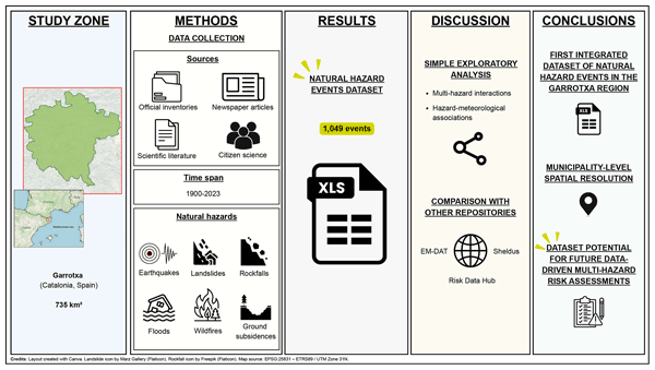
Data-driven approaches are increasingly essential for understanding complex, interacting natural hazards. We present a natural hazard events dataset compiling all documented occurrences of earthquakes, landslides, rockfalls, floods, wildfires, and ground subsidences in the Garrotxa region (Catalonia, Spain) between 1900 and 2023. The dataset integrates inventoried, written, and oral sources, including official inventories, historical press, scientific literature, and citizen-science contributions, which were processed and cross-validated to remove duplication and inconsistencies. A total of 1049 events were compiled. A simple exploratory analysis illustrates the potential of the dataset for multi-hazard interaction and hazard–meteorological associations. Comparison with national and international repositories (e.g., EM-DAT, SHELDUS, Risk Data Hub) shows that this dataset provides higher spatial resolution and includes locally validated records absent elsewhere. The study therefore contributes both a new regional data resource and a workflow for compiling and validating heterogeneous hazard data, supporting future susceptibility and multi-hazard risk analyses in this and other regions.
- Article
(9254 KB) - Full-text XML
-
Supplement
(504 KB) - BibTeX
- EndNote


Understanding natural-hazard risk requires consistent knowledge of where and when past hazard events have occurred. While risk represents the potential for losses arising from the interaction of hazards, exposure, and vulnerability, hazard events are the observable manifestations, such as earthquakes, floods, wildfires, etc, that underpin quantitative and qualitative risk analyses. Global frameworks such as the United Nations Office for Disaster Risk Reduction (UNDRR) Sendai Framework (2015) emphasize multi-hazard perspectives, yet implementation at local scales remains limited by the scarcity of harmonized event data (e.g., Hewitt and Burton, 1971; Kappes et al., 2012; Gill and Malamud, 2014; UNDRR, 2016; Tilloy et al., 2019; de Ruiter et al., 2020; Gill et al., 2022).
In regions like Garrotxa (Catalonia, Spain), environmental, geological, and climatic diversity leads to the occurrence of multiple hazards that may interact temporally or spatially. However, the available information is typically fragmented among institutions, stored in incompatible formats, and rarely cross-validated. This fragmentation hinders both single-hazard and multi-hazard risk assessments.
The present study aims to contribute to the improvement of multi-hazard risk assessments by enabling future data-driven analyses. For this, it addresses three main questions: (1) What is the historical record of natural-hazard events that have affected the Garrotxa region between 1900 and 2023? (2) How do these events relate spatially and temporally, indicating potential interactions (e.g., rainfall-induced landslides or earthquake-triggered rockfalls)? (3) How does the resulting dataset compare with existing national and international repositories, and what added value does it offer for future multi-hazard risk assessment? By answering these questions, the work provides a bridge between data compilation and applied risk-analysis frameworks.
This paper introduces a hazard event dataset, instead of a probabilistic hazard model. A hazard map quantifies the probability of an event of given magnitude within a specific period (e.g., Calder et al., 2015; Lindell, 2020; MacPherson-Krutsky et al., 2020), whereas a hazard event dataset records the actual, observed occurrences over time (e.g., St. Denis et al., 2023; Bisquert et al., 2025). Both are complementary: the latter supplies empirical evidence necessary to calibrate, validate, and contextualize the former.
Existing open datasets such as EM-DAT (CRED, 2025), SHELDUS (CEMHS, 2025), or Risk Data Hub (DRMKC, 2025) operate at national or continental scales but often lack spatial precision or local validation. At the regional scale of the Garrotxa region, no integrated repository of natural-hazard events across multiple hazard types previously existed. The dataset presented here therefore fills a critical resolution gap, enabling finer-scale analyses of hazard frequency, clustering, and potential interrelationships. In this sense, the present study contributes methodologically by integrating heterogeneous data sources (official, historical, and citizen-science), outlining a reproducible workflow for data processing and validation, and demonstrating how such data can inform susceptibility and multi-hazard risk modelling.
The following sections describe the study area, data-identification and processing methods, the resulting dataset structure, and a preliminary exploration of hazard interrelationships in the Garrotxa region.
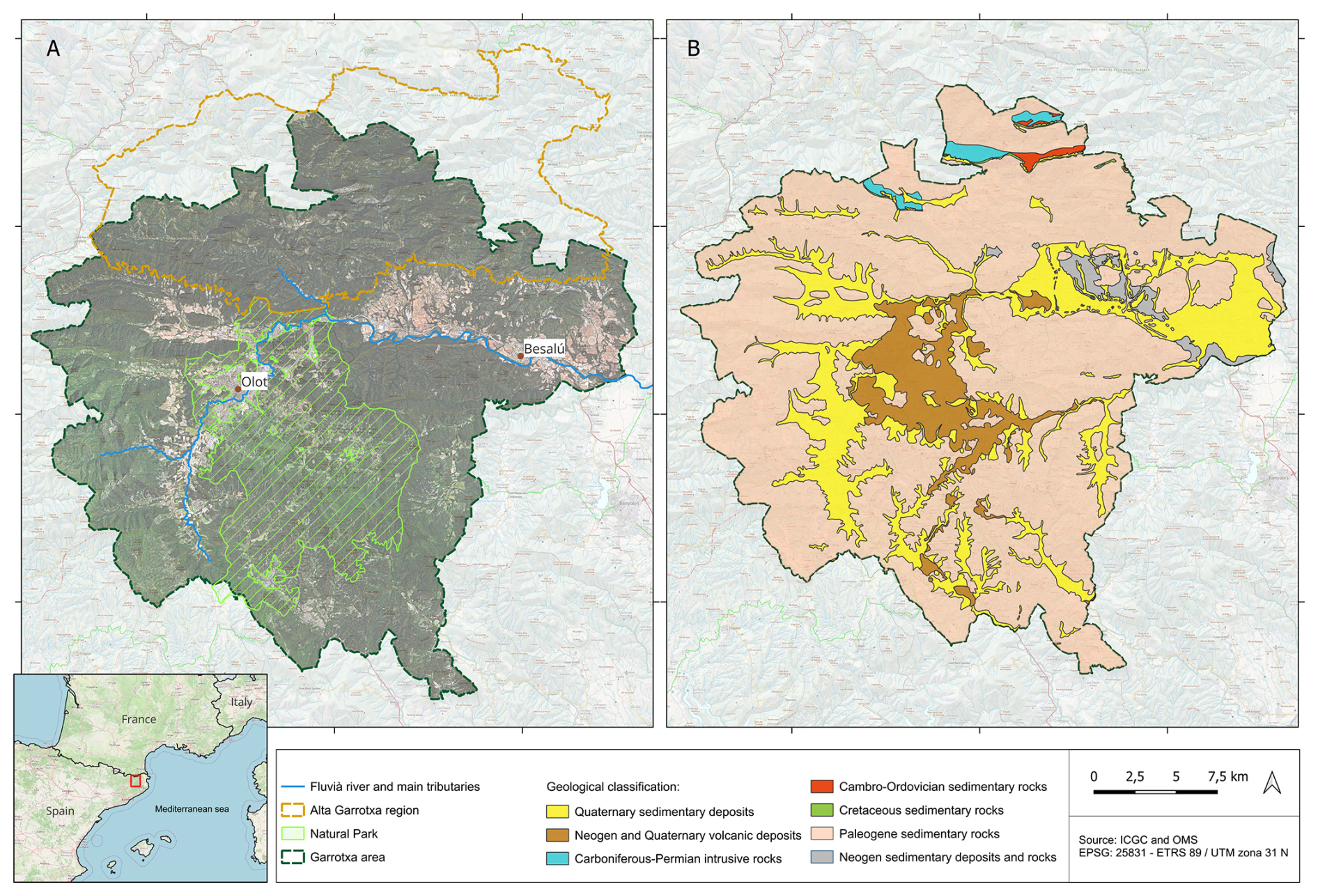
Figure 1Study area. (A) Location and geographical map of the Garrotxa region. (B) Lithological map of the Garrotxa region. Base map service of the Cartographic and Geological Institute of Catalonia (ICGC), under a CC BY 4.0 license.
2.1 Geographical, geological and socio-economical setting
The Garrotxa region is located in the northeastern part of Catalonia, within the province of Girona, Spain (Fig. 1A). It is characterized by a mountainous landscape and significant geological diversity, with the most distinctive feature being the Garrotxa Volcanic Zone Natural Park. This protected area represents the most well-preserved volcanic landscape in the Iberian Peninsula, comprising over fifty volcanic cones and extensive lava flows (Martí et al., 2016). Two different relief units can be distinguished in the Garrotxa region (Fig. 1A, B) and the limit between the two sectors is marked by the Vallfogona thrust that runs from west to east (Martínez-Rius et al., 1990) (Fig. 1).
The Alta Garrotxa is part of the pre-Pyrenees mountain range. It covers the northern part of Garrotxa and extends beyond it. It is formed by cliffs and karstic relief originating from the east–west Alpine antiforms with Eocene limestones and Garumnian lutites. In the core of the folds, granites and schists outcrop the Paleozoic. In this area, the valleys are very closed and steep, with canyons produced by karstic erosion and mainly dominated by tectonic structures in the form of folds and thrusts in an east–west direction produced by the Alpine orogeny (65 to 35 Ma).
The center and the south of the Garrotxa region are part of the Transversal mountain range of Catalonia, here composed of Eocene marls and sandstones. They are faulted by the Neogene (20 Ma to present) tectonic structures that form part of the European Rift. This area shows a flatter bottom and less abrupt reliefs as a result of the Quaternary volcanism and sedimentation (0.3 Ma to early Holocene) (Martí et al., 2025). The different lava flows and sediments accumulated by the past volcanic eruptions have formed the valleys of Bas, Olot, Santa Pau and Brugent. The Fluvià River traverses the region from west to east, playing a crucial role in shaping the local environment and hydrological dynamics.
The climate conditions of the Garrotxa region are classified as Mediterranean with montane influences, characterized by cold winters and mild summers. Precipitation levels are relatively high, which, together with the fertile volcanic soils, fosters the development of extensive forests, such as the beech forest of La Fageda d'en Jordà, one of the most ecologically significant ecosystems in the region (Garrotxa Tourism, 2025).
Beyond its geological and geographical characteristics, the Garrotxa region also possesses distinct socio-economic features that make it particularly suitable for a study like this. First of all, Garrotxa is the only mountainous administrative region of Catalonia with more than 20 000 inhabitants (GarrotxaDigital, 2022). Additionally, with a total area of 734.5 km2, the region is highly accessible, and numerous scientific work has been conducted there, providing valuable knowledge of the zone (e.g., Bartolini et al., 2015; Varga et al., 2018; Revelles et al., 2023). 91 % of the residents of the Garrotxa region live in urban settlements (SIGMA, 2023). Olot, the regional capital, is home to 38.836 people (Idescat, 2025a), accounting for more than half of the total population of Garrotxa. The second most populated municipality, La Vall d'en Bas, has only 3221 inhabitants (Idescat, 2025b). Therefore, although Olot is a small to mid-sized city, it functions as a metropolitan hub for the region. The remaining 9 % of the population resides in dispersed settlements (SIGMA, 2023). This population distribution reflects a broader trend in Catalonia, where only the province of Barcelona accounts for almost 73 % of the total population (Gencat, 2023).
Thus, Garrotxa serves as a valuable study area, representing a larger demographic pattern. Additionally, Garrotxa has a strong economic activity. Despite being a mountainous area, 42 % of the workforce is employed in industry, making it the second-largest economic sector of the region (SIGMA, 2023). As a result, the unemployment rate remains below 10 %, slightly lower than the Catalonian average (SIGMA, 2023). Industrial growth has driven the development of major road infrastructure in the region, creating strong connections to key destinations such as Barcelona, the French border, the high-speed train station in Figueres-Vilafant, and Girona-Costa Brava Airport. Both industrial and transport infrastructure in Garrotxa can be treated as vulnerable elements, which have to be included in risk assessment and management studies.
Moreover, tourism is another important income for Garrotxa, which is attracted by its great natural beauty. In 2023, Garrotxa welcomed 192 109 tourists (overnight stays), while 559 515 people visited the Garrotxa Volcanic Zone Natural Park (Turisme Garrotxa, 2023). However, the growing number of visitors has raised concerns about overcrowding in natural areas of Garrotxa, especially in water ponds during summer and in La Fageda d'En Jordà during autumn.
2.2 Natural hazards in the Garrotxa region
The Garrotxa region, characterized by its volcanic geomorphology, mountainous terrain, and Mediterranean climate, is exposed to multiple natural hazards. Although the volcanic activity in the region remains dormant (Martí et al., 2025), other geological and hydrometeorological threats, including seismicity, landslides, flooding, and wildfires, present ongoing risks to both the environment and local communities (Vilaplana et al., 2008; Ajuntament d'Olot, 2022).
Seismic activity, while generally moderate, is influenced by the proximity to the Pyrenean tectonic boundary and the presence of Neogene-Quaternary active normal faults (ICGC, 2006; Bolós et al., 2015). Despite large-magnitude earthquakes in the region are relatively infrequent, moderate and low seismicity located along the main Neogene faults that cross the study area are common (Secanell et al., 2004; Ajuntament d'Olot, 2006; Jiménez and García, 2008; Departament d'Interior i Seguretat Pública, 2021). This seismicity, while rarely destructive, highlight the underlying geodynamic instability of the region (IGN, 2017; ICGC, 2020).
The steep topography, combined with intense seasonal precipitation and soil saturation, contributes significantly to landslide susceptibility (Palau et al., 2023). The many slopes, composed of weathered volcanic materials and unconsolidated sediments, are particularly prone to mass-wasting events following prolonged rainfall or seismic activity (ICGC, 2026; Copons, 2008a). Landslides can disrupt transportation infrastructure, alter river courses, and threaten residential areas in both the highlands and foothill zones. Additionally, rockfall hazard is well-established at Castellfollit de la Roca. This municipality is characterized by a prominent, columnar-jointed basalt cliff standing above less cohesive alluvial and pyroclastic layers, whose differential erosion and fractures contribute to frequent rockfall hazards (Abellán et al., 2011; Bassols and Calm, 2018; Janeras et al., 2023).
Hydrometeorological hazards, particularly flooding, represent another major concern. The Fluvià River and its tributaries frequently experience episodes of rapid water level rise, particularly during extreme precipitation events (Escuer, 2008; Departament d'Interior i Seguretat Pública, 2015; SIGMA, 2017). The combination of steep catchments and variable rainfall patterns promotes flash flooding, which can impact urban areas such as Olot and pose significant threats to agricultural productivity (ACA, 2024). The increasing incidence of extreme weather events, attributed to ongoing climatic shifts, has further exacerbated flood risks in recent decades (Barriendos et al., 2019; Llasat, 2021; Sharma et al., 2021).
Soil erosion, closely linked to hydrological instability, is particularly pronounced in the volcanic soils of Garrotxa, which are highly susceptible to weathering and displacement (Palou et al., 2010; Planagumà-Guàrdia et al., 2022). Factors such as deforestation, changes in land-use practices, and overgrazing have intensified soil degradation, especially on inclined terrain, leading to loss of arable land and increased sedimentation in river systems.
Wildfires remain a persistent risk, particularly in densely forested areas dominated by Mediterranean oak and beech woodlands (Consell Comarcal de la Garrotxa, 2021; Departament d'Interior i Seguretat Pública, 2024). The dry summer season, coupled with increased temperatures and periodic droughts, creates favorable conditions for fire ignition and rapid spread (Pausas and Fernández-Muñoz, 2012; Turco et al., 2019; Duane et al., 2021). The expansion of forested areas due to rural depopulation has further increased fuel availability, heightening wildfire risks (Vila-Subirós et al., 2014).
Ground subsidences are concentrated in the eastern part of the study area, particularly in the municipality of Besalú. This trend has been documented by previous investigations on the evaporite karst system developed within the geological complex of the Fluvià Valley (Copons, 2008b; Gutiérrez et al., 2016).
Regarding volcanic hazard in the Garrotxa volcanic field, the area is considered active, with the most recent period of volcanic activity covering the last 250 ka (Martí et al., 2025). The most recent eruption in this zone has traditionally been dated to the early Holocene (11–13 ka), although recent studies suggest it may have occurred as recently as ∼8 ka (Revelles et al., 2023; Martí et al., 2025). Volcanic activity in Garrotxa has ranged from effusive Hawaiian-style eruptions to more explosive Strombolian episodes, with numerous phases of phreatomagmatic activity (Martí et al., 2011). This volcanism is structurally controlled by the main regional normal faults formed during the Neogene extensional phase that affected the area (Bolós et al., 2015). Bartolini et al. (2015) identified five distinct hazard levels in the Garrotxa volcanic field, based on simulations of lava flows, pyroclastic density currents (PDCs), and fallout scenarios.
In recent years, climate change has played a significant role in amplifying the frequency and intensity of extreme weather phenomena in the region, including heatwaves, droughts, strong wind events, and intense rainfall episodes while at the same time contributing to a marked decline in snowfall events (OPCC and CTP, 2018; Cortès et al., 2019; METEOCAT, 2024). These changes have compounded existing hazards, necessitating a more comprehensive approach to risk assessment and mitigation strategies in the Garrotxa region.
3.1 Data identification
The dataset spans 1 January 1900–31 December 2023, chosen to ensure a century-scale temporal window suitable for trend and recurrence analysis while maintaining reliable documentation. Six hazard types were included: earthquakes, landslides, rockfalls, floods, wildfires, and ground subsidences. Selection was guided by (1) their risk relevance in Garrotxa, (2) data availability within the study period, and (3) their potential interactions in a multi-hazard framework. In reference to this last criterion, relevant scientific literature was reviewed (e.g., Gill and Malamud, 2014; Zscheischler et al., 2020; López-Saavedra and Martí, 2023; Lee et al., 2024; UNDRR and ISC, 2025) to identify cascading or triggering relationships that could plausibly occur in a region with the characteristics of Garrotxa, such as earthquake-induced landslides, rainfall-triggered landslides, or landslide-induced flooding resulting from the formation of natural dams and subsequent overbank flow. Volcanic activity, though geologically important, was excluded because its most recent eruption (∼8 ka BP; Revelles et al., 2023) falls outside the historical timeframe.
The dataset was intentionally structured using a single-hazard approach, in which each hazard occurrence is recorded individually rather than being classified a priori as part of a multi-hazard event. This design choice minimizes subjective interpretation during data compilation and preserves event-level information, allowing potential hazard interrelationships to be explored subsequently through data-driven analyses of temporal and spatial co-occurrence.
To guide the data collection strategy, we first identified the main variables commonly used to characterize the selected natural hazards. This step aimed to ensure that the dataset would be compatible with existing hazard modelling approaches and could support future analyses.
Table 1Conceptual classification of hazard-related variables used to guide dataset compilation.
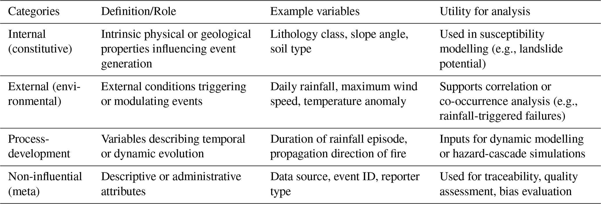
The identification of relevant variables was based on three complementary sources: (1) a review of existing hazard models to identify commonly used input parameters (e.g., IBER for floods (Bladé et al., 2014), RockGIS for rockfalls (Matas et al., 2017), Cell2Fire for wildfires (Pais et al., 2019), FSLAM for landslides (Medina et al., 2021; Guo et al., 2022), and the Peak Ground Acceleration QGIS plugin (Núñez-Murillo, 2017)); (2) a review of scientific literature and additional expert consultation; and (3) the previous experience of the authors in natural hazard research.
Once the relevant variables had been identified, they were conceptually classified into four analytical categories (Table 1): (1) internal or constitutive variables, representing intrinsic physical or geological properties influencing hazard occurrence; (2) external or environmental variables, describing external conditions that may trigger or modulate events; (3) process-development variables, capturing the temporal or dynamic evolution of events; and (4) non-influential or meta variables, corresponding to descriptive or administrative attributes related to data documentation.
Table 2Summary of the different inventory sources and methods used to collect the natural hazard events occurred in the Garrotxa region (1900–2023).
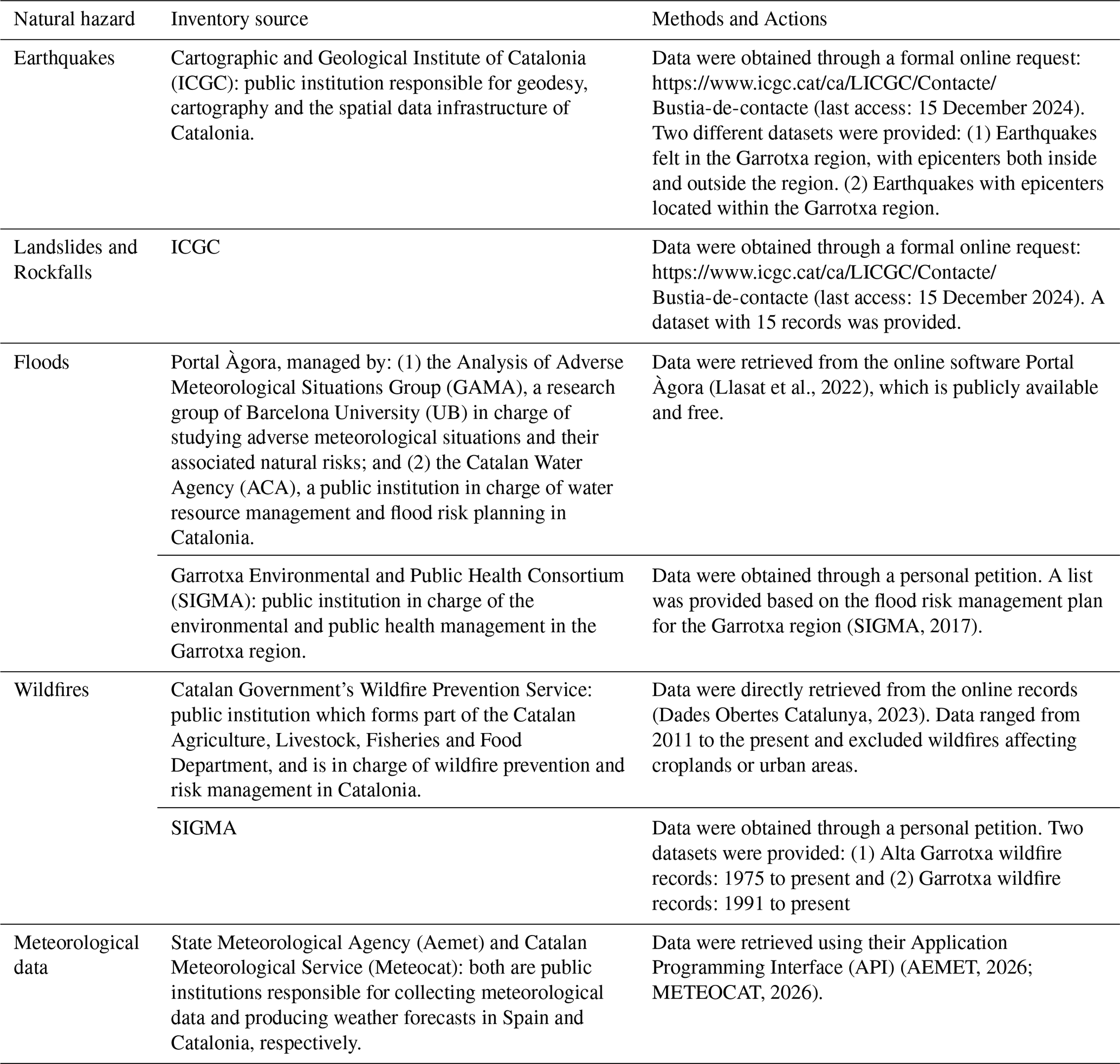
Table 3Summary of the different written sources and methods used to collect the natural hazard events occurred in the Garrotxa region (1900–2023).
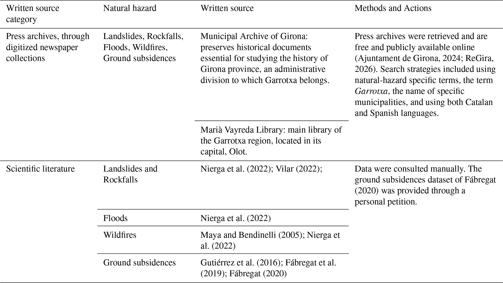
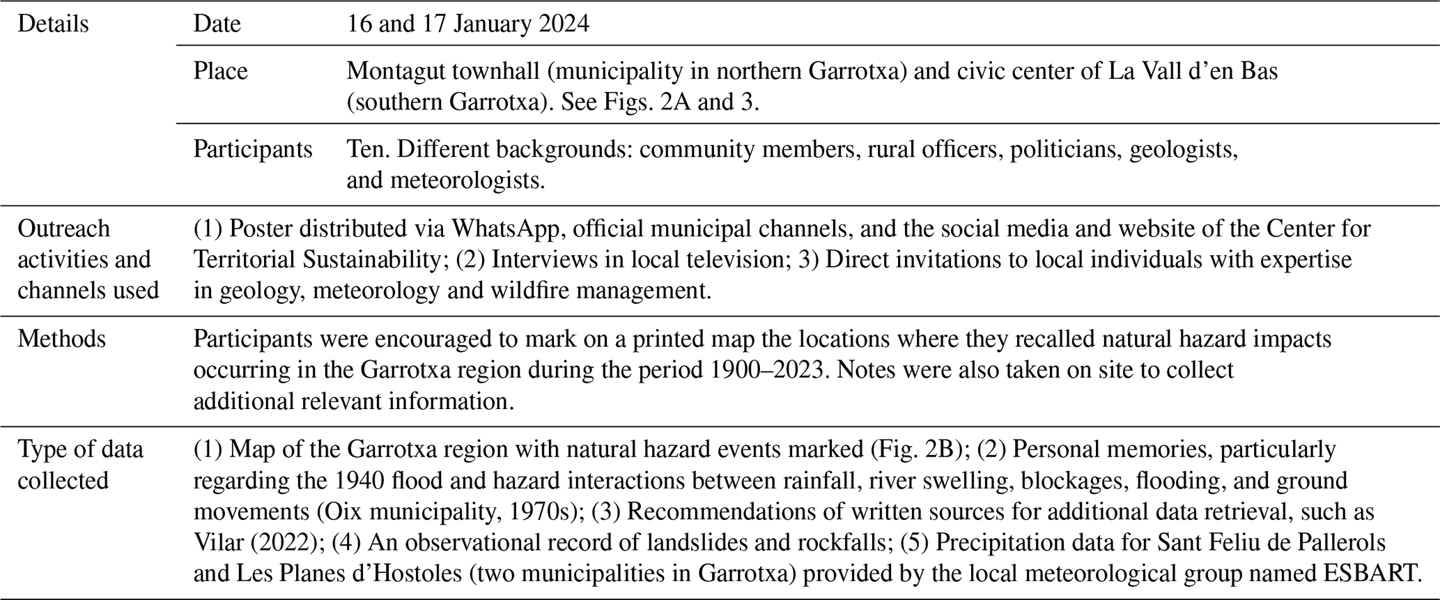
This classification was used as a conceptual framework to guide the compilation of the historical dataset. However, during data collection it became evident that many theoretically relevant variables were not consistently reported in historical sources such as press archives or oral testimonies. As a result, the final dataset includes a combination of theoretically informed variables and surrogate variables (e.g., “affected_municipality”, “np_ini_date”, “np_fin_date”) adapted to the level of detail available in the available sources.
3.2 Data collection
Data were collected from three complementary source categories (Tables 2 to 4): (1) inventoried datasets from official institutions (e.g., ICGC seismic catalogues, ACA flood inventories, and the wildfire database of the Catalan Government), obtained via formal data-sharing requests; (2) written sources, including historical newspapers and scientific literature, retrieved through digital archives (e.g., Arxiu Municipal de Girona, ReGira) using bilingual keyword searches (Catalan/Spanish); and (3) oral and citizen-science sources, gathered through two workshops (Montagut and La Vall d'en Bas) involving several participants with local and technical knowledge. Participants annotated printed maps and provided recollections, particularly regarding major floods and slope instabilities.
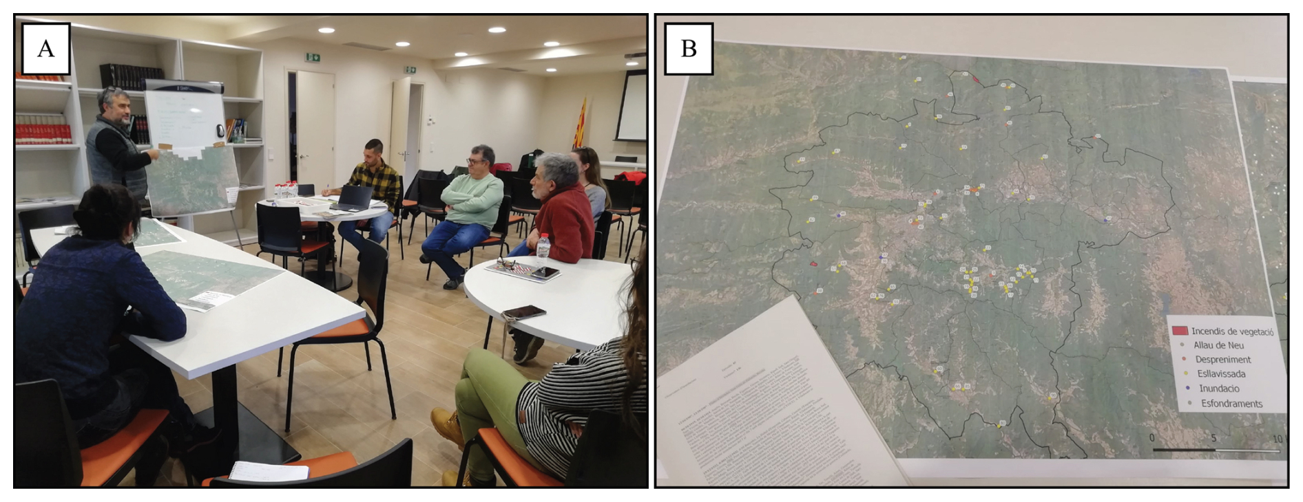
Figure 2(A) Participants in the workshop held in Montagut on 16 January 2024. (B) Printed map of the Garrotxa region used during the citizen science workshops.
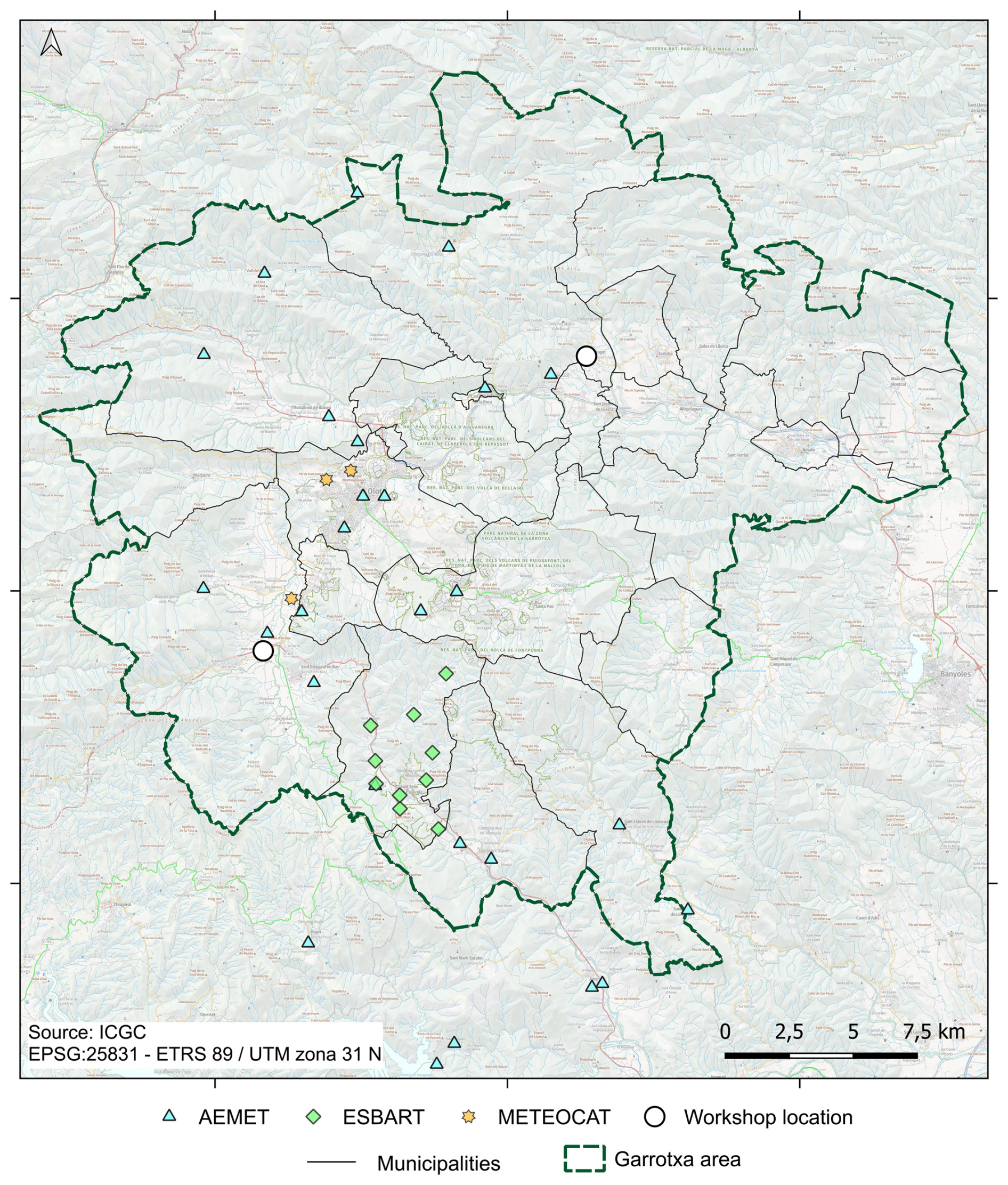
Figure 3Map showing the meteorological stations from various sources (Aemet, Meteocat, and ESBART) used for data collection, along with the locations of the citizen science workshops held. Base map service of the Cartographic and Geological Institute of Catalonia (ICGC), under a CC BY 4.0 license.
All sources were georeferenced, standardized, and entered into a unified relational structure. Each record includes metadata on provenance and reliability.
3.3 Data processing and validation workflow
Raw data were processed in two stages: (1) Standardization and merging: Temporal data reformatted to DD-MM-YYYY, and spatial coordinates converted to UTM Zone 31 N (EPSG:25831); (2) Duplicate detection and cross-validation: Automated string and coordinate matching in Python identified potential duplicates (e.g., two reports of the same flood). All candidates were manually checked against source texts. Discrepancies between institutions (e.g., AEMET vs METEOCAT rainfall units) were resolved through conversion scripts. A more detailed description of the data processing procedures is provided in the Supplement.
As for data cross-validation and quality assurance, three methods were applied: (1) Spatial verification: events plotted in QGIS and visually checked against topographic basemaps; (2) Expert review: geologists from SIGMA and the Natural Risks Assessment and Management Service (NRAMS) verified 100 randomly selected entries for plausibility; and (3) Uncertainty documentation: the fields “np_ini_date” (non-precise initial date) and “np_fin_date” (non-precise final date) are used to record uncertainty arising from the absence of exact dates in the written and oral sources consulted. This multi-layer validation ensures that even heterogeneous, century-spanning information attains consistent standards for subsequent analysis.
4.1 Dataset overview
The finalized Garrotxa natural hazard event dataset contains 1049 records covering six hazard types: Wildfires (264), Earthquakes (246), Floods (242), Ground subsidences (137), Landslides (114), and Rockfalls (46) (Fig. 4). The final table has a total of 45 categorized variables spanning location, timing, physical descriptors, triggering factors, and metadata fields for quality control. About 73 % of events derive from inventoried sources and 27 % from non-inventoried written or oral materials (Fig. 5). Temporal coverage is uneven, with a clear increase in reporting after 1980, reflecting improved monitoring and media documentation. This bias does not necessarily indicate higher hazard frequency but improved detectability and institutional recording capacity.
The dataset is publicly available at https://digital.csic.es/handle/10261/394924 (Lagresa et al., 2025). Table S1 in the Supplement provides information on the coordinate reference system used for geolocating the different natural hazard events, as well as the codes, descriptions, units (where applicable) or examples for each variable collected across the various natural hazards.
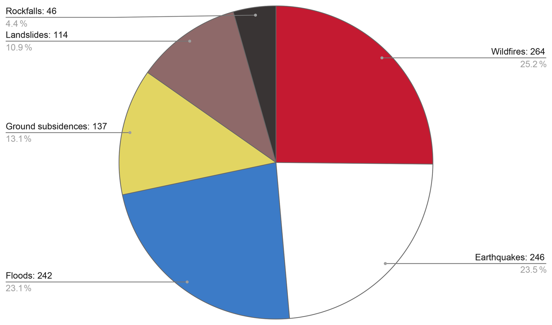
Figure 4Total recorded events in the Garrotxa region (1900–2023), distributed by type of natural hazard (wildfires, rockfalls, landslides, ground subsidences, earthquakes and floods).
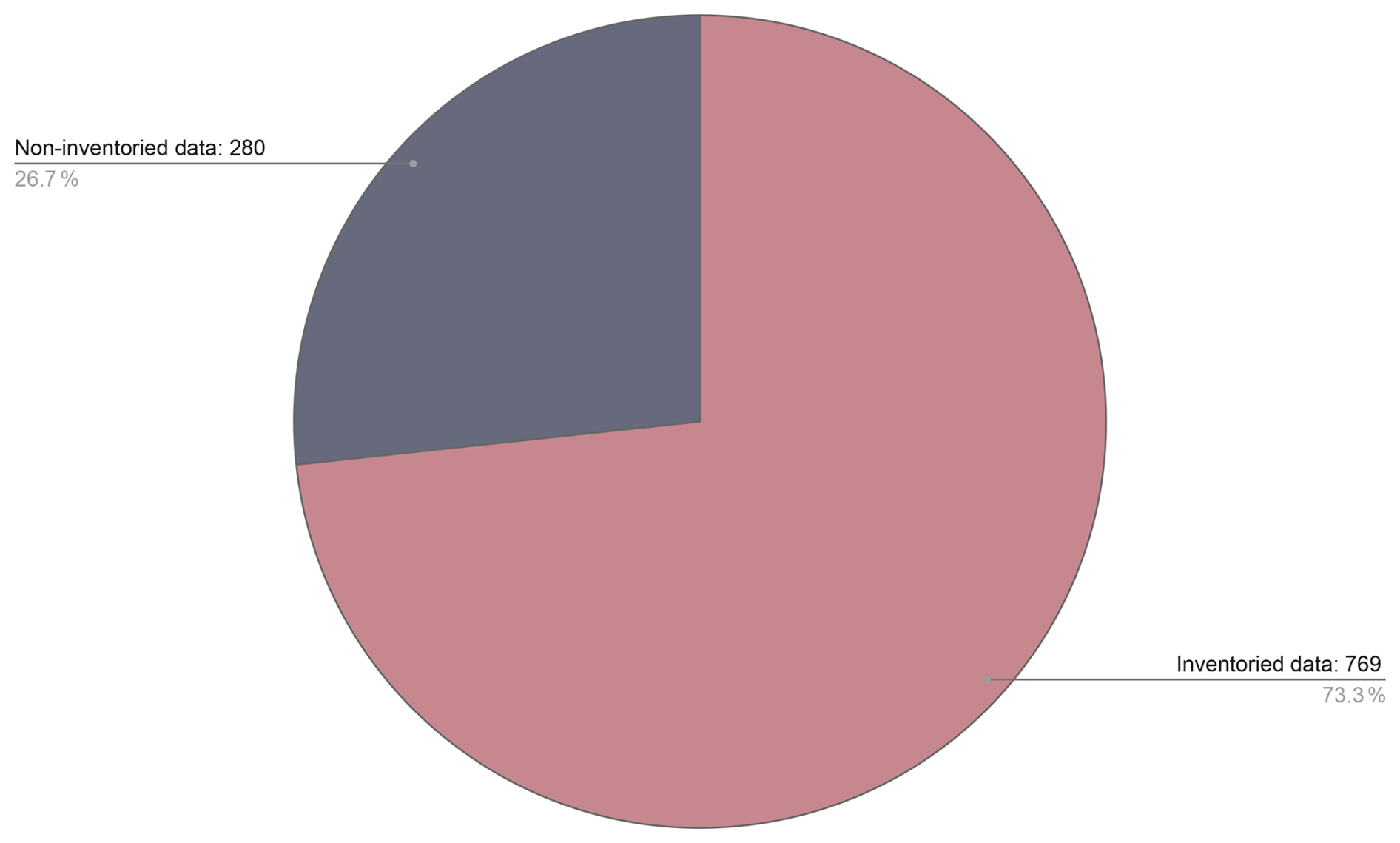
Figure 5Percentage of recorded natural hazard events in the Garrotxa region (1900–2023) by data source (previously inventoried and non-inventoried).
4.2 Preliminary analysis of hazard interrelationships
Although the primary purpose of the dataset is descriptive, a simple exploratory analysis was performed to illustrate its potential for multi-hazard investigation. We examined temporal and spatial co-occurrence among hazard events using a simple yet realistic procedure, intended solely for demonstration purposes.
Table 5Assumed temporal and spatial windows for trigger–hazard co-occurrence used in the exploratory analysis.

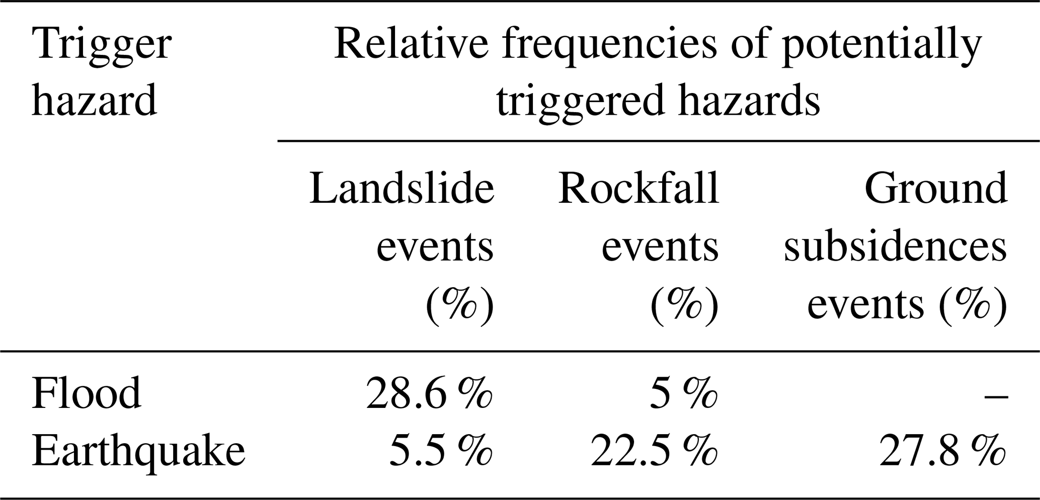
Table 6Relative frequencies (expressed as percentages) of potentially triggered hazard events (columns) that were temporally and spatially associated with a given trigger hazard (rows), according to the assumed criteria. The symbol “–” indicates that no interrelated occurrences were identified for the corresponding hazard combination under the adopted criteria.
First, heuristic assumptions regarding potential temporal and spatial relationships between triggering hazards and subsequently triggered hazards were defined. These assumptions were informed by a preliminary inspection of the dataset, prior geological knowledge of the study area, and by existing literature describing interactions between natural hazards (e.g., Gill and Malamud, 2014; UNDRR and ISC, 2025).
Based on these considerations, plausible temporal and spatial windows were defined to explore potential trigger–response relationships within the dataset. These thresholds do not represent definitive physical limits but were selected as heuristic values to illustrate how the dataset can be used to explore possible multi-hazard interactions. The assumed trigger–response relationships and the corresponding temporal and spatial windows are summarized in Table 5. Wildfire and ground subsidences were not considered as triggering hazards for other events in this exploratory analysis. Ground subsidences were only evaluated as potentially triggered hazards. Wildfires were excluded from the interrelationship analysis due to their predominantly anthropogenic origin in La Garrotxa, which limits the interpretability of temporal and spatial associations within the adopted analytical framework. Therefore, a total of 912 events out of the total of 1049 were finally considered for this analysis.
Out of the 912 events considered, 79 (approximately 8.4 %) participated in at least one potential interrelated occurrence. Table 6 presents a sample of the observed relative frequencies of these interrelations. Percentages are calculated with respect to the total number of events of each potentially triggered hazard type and indicate the proportion of those events that were temporally and spatially associated with a given trigger hazard, according to the adopted criteria. For example, 28.6 % of landslide events were temporally and spatially associated with flood occurrences within a 7 d window and a 2 km distance threshold.
In addition to hazard–hazard interrelations, a complementary exploratory analysis was conducted to examine associations between selected natural hazards and meteorological conditions. For this purpose, a set of simple meteorological thresholds was defined, and hazard occurrences were evaluated with respect to whether they coincided with these conditions within the relevant temporal context.
Table 7 summarizes the most characteristic hazard–meteorological associations identified. Percentages represent the proportion of events of each hazard type that occurred under the specified meteorological conditions. These associations are intended to illustrate potential links between hazards and meteorological drivers, rather than to establish causal relationships.
Table 7Relative frequencies (expressed as percentages) of hazard events occurring under selected meteorological conditions. Percentages are calculated relative to the total number of events of each hazard type. The symbol “–” indicates that no associations were identified under the adopted criteria.
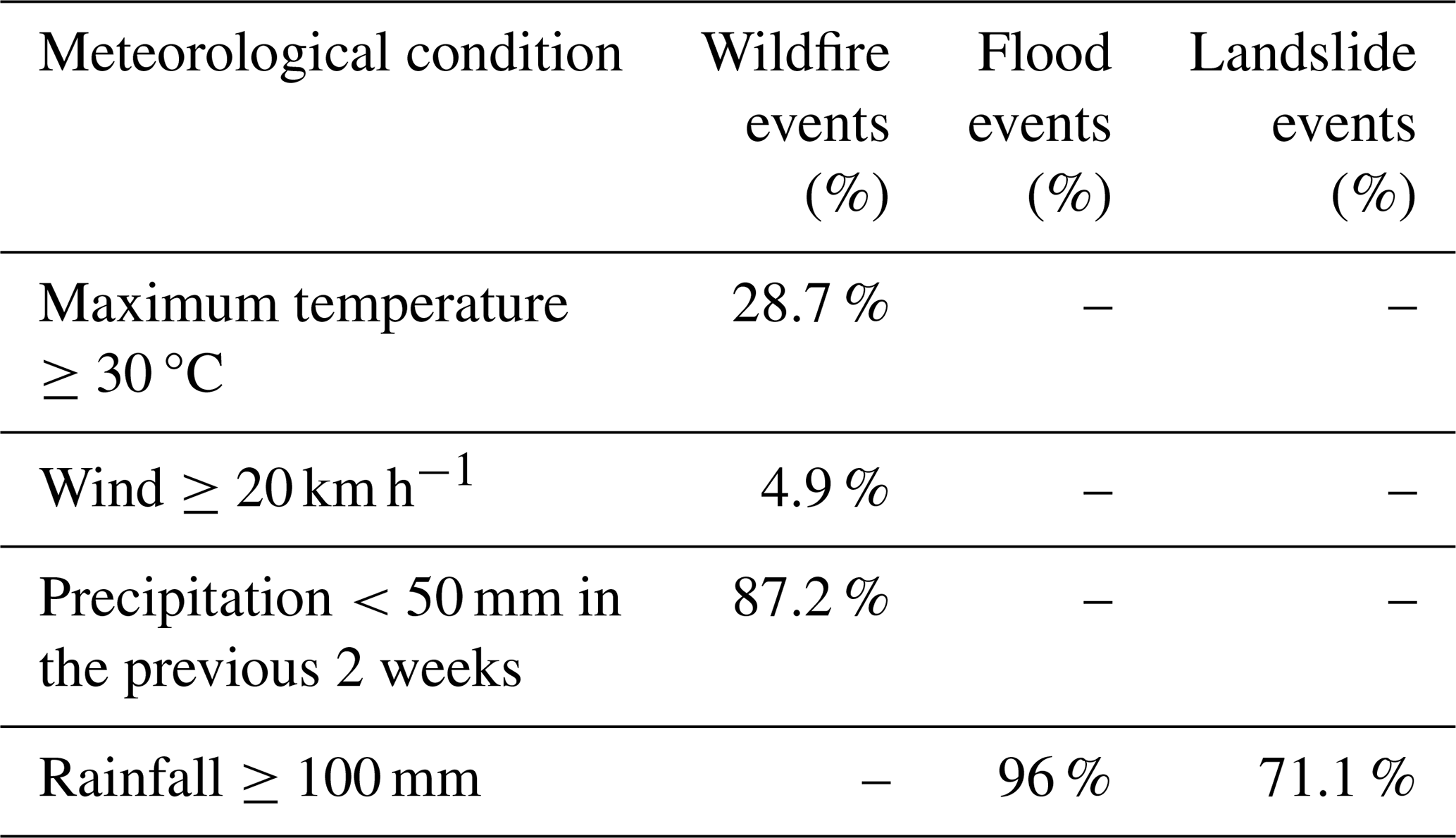
Patterns observed in Tables 6 and 7 are broadly consistent with commonly reported multi-hazard sequences and hazard-meteorology in Mediterranean mountain regions (e.g., Guzzetti et al., 2007; Turco et al., 2018; Rodríguez-Peces et al., 2020). In particular, rainfall-driven processes appear to dominate, with intense precipitation episodes frequently associated with flood occurrences and slope instabilities (Table 7). Seismic activity is occasionally followed by localized rockfalls or minor ground subsidences, although associated magnitudes are generally low (ML <4) (Table 6). In addition, wildfire occurrences tend to coincide with periods characterized by limited precipitation over several consecutive days and elevated temperatures, as reflected in the adopted meteorological thresholds (Table 7). These associations are consistent with the regional climatic setting but should be interpreted cautiously, as they do not imply direct causality.
The temporal distribution of identified interrelations reflects a recency bias, with approximately 66 % of associations occurring after 2011. This pattern likely results from both an increased reporting of hazard events and a substantial improvement in detection and documentation capabilities in recent decades.
A key limitation of the present analysis remains the uneven quantity of available data across events. Interrelationships are more readily identified for well-documented episodes, such as major storms (e.g., the Gloria event in January 2020), where several hazards were widely reported and therefore recorded as separate entries in the dataset. As a result, potential interactions become easier to detect in such cases, highlighting the importance of data completeness for robust multi-hazard analysis.
Although preliminary and based on synthetic aggregation, these findings demonstrate the capacity of the dataset to support exploratory multi-hazard association and causal-chain analyses once more complete and probabilistic information becomes available.
4.3 Spatial and temporal distribution
Visualization in QGIS (Fig. 6) reveals several areas where different hazards spatially overlap, including: (1) the Fluvià River valley, where flood and landslide are both present; (2) the Bas and Santa Pau valleys, combining volcanic substrates and steep slopes conducive to slope instability; and (3) the Alta Garrotxa range, showing numerous wildfire and rockfall events. Such clustering supports the identification of priority areas for integrated risk mitigation rather than single-hazard interventions.
Concerning temporal distribution, Fig. 7 shows an apparent rise in hazard occurrence after 2000. While partly due to improved reporting, this trend coincides with observed regional increases in extreme rainfall frequency and summer heatwave duration, aligning with findings from the Catalan Meteorological Service (Meteocat, 2024). The dataset therefore also offers an empirical basis for studying climate-hazard linkages at the regional scale.
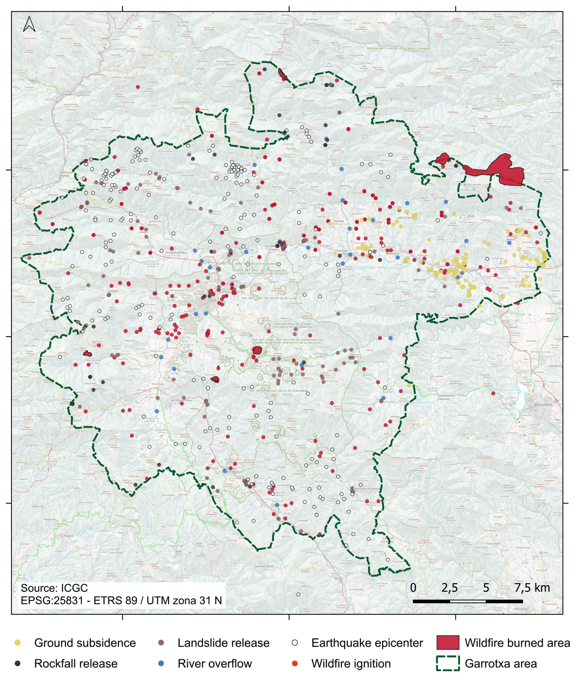
Figure 6Geographical distribution of the total recorded natural hazard events occurred in the Garrotxa (1900–2023). Base map service of the Cartographic and Geological Institute of Catalonia (ICGC), under a CC BY 4.0 license.
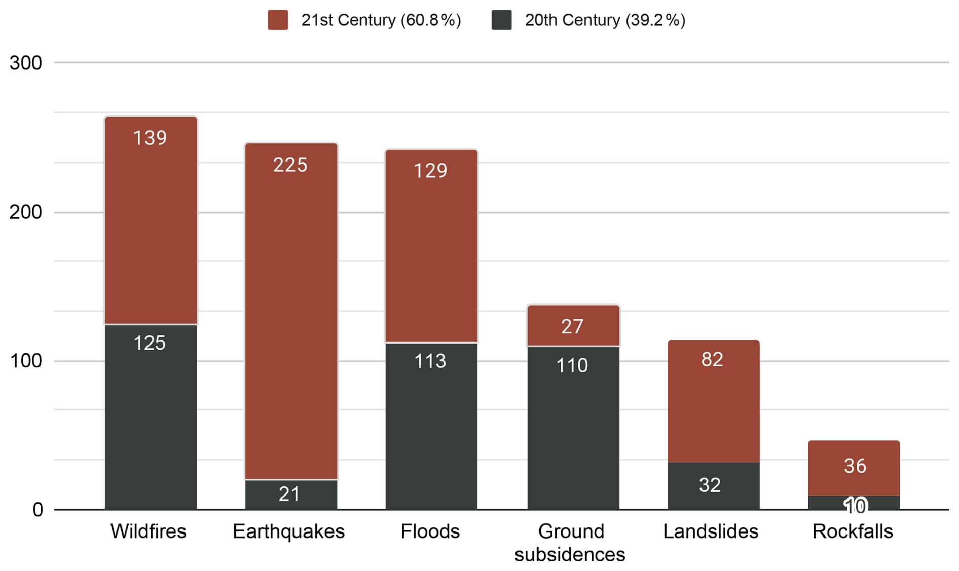
Figure 7Total recorded events for each natural hazard in the Garrotxa region (1900–2023), distributed by century (20th and 21st).
5.1 Dataset value and comparison with existing repositories
The Garrotxa natural hazard event dataset fills a unique spatial and thematic gap between global/national repositories (e.g., EM-DAT, SHELDUS, Risk Data Hub) and local administrative records. Compared with EM-DAT, which lists only disasters causing major economic losses or fatalities, our dataset captures all scales of events, including minor but frequent slope movements and small wildfires that shape local vulnerability. In contrast to SHELDUS (county-level U.S. data) or the Copernicus Emergency Management Service (European-scale), the Garrotxa dataset reaches municipality-level geospatial resolution (<250 m). Moreover, it integrates non-institutional information such as historical newspapers and citizen-science memories, rarely present in official inventories.
From a scientific perspective, these differences translate into three clear contributions: (1) Enhanced resolution and completeness, supporting validation of susceptibility models that require fine-scale inputs; (2) Inclusion of cultural memory, linking physical events with community perception, crucial for risk-communication studies; and (3) Interoperable structure, as variables follow common vocabularies (e.g., INSPIRE, UNDRR Hazard Glossary), facilitating cross-dataset integration at European scale. Thus, the dataset moves beyond a purely archival purpose and becomes an enabling infrastructure for multi-hazard data-driven research.
5.2 Workflow toward multi-hazard risk assessment
The dataset forms the first step in a chain leading to a comprehensive multi-hazard risk analysis. Figure 8 (described below) outlines the sequential steps and data requirements in this process. Step 1, Hazard Event Dataset (Observed Data), uses an empirical record of past events, as detailed in this study. Step 2, Susceptibility Mapping, identifies the relative likelihood (low to high classes) of a hazard occurring at a specific location, based on intrinsic and environmental factors such as slope, lithology, and rainfall. Step 3, Hazard Mapping, integrates susceptibility data with the probability of an event occurring within a given time frame, such as flood inundation probability for 50- or 100-year return periods. Step 4, Exposure Assessment, overlays spatial data to identify exposed elements like people, buildings, infrastructure, and ecosystems. Step 5, Vulnerability Analysis, quantifies potential damage or loss for each exposed element. Step 6, Multi-Hazard Integration and Risk Mapping, combines hazard layers using weighting or network models to represent cascading or compound effects. Finally, Step 7, Decision Support and Policy Feedback, produces outputs that inform risk management plans, emergency preparedness, and climate adaptation strategies.
A susceptibility map expresses the relative predisposition of a location to event initiation, while a hazard map quantifies the probability of a given event magnitude occurring within a specified period. Not all hazard types have both products routinely: landslides, for example, often have susceptibility maps but rarely fully probabilistic hazard maps.
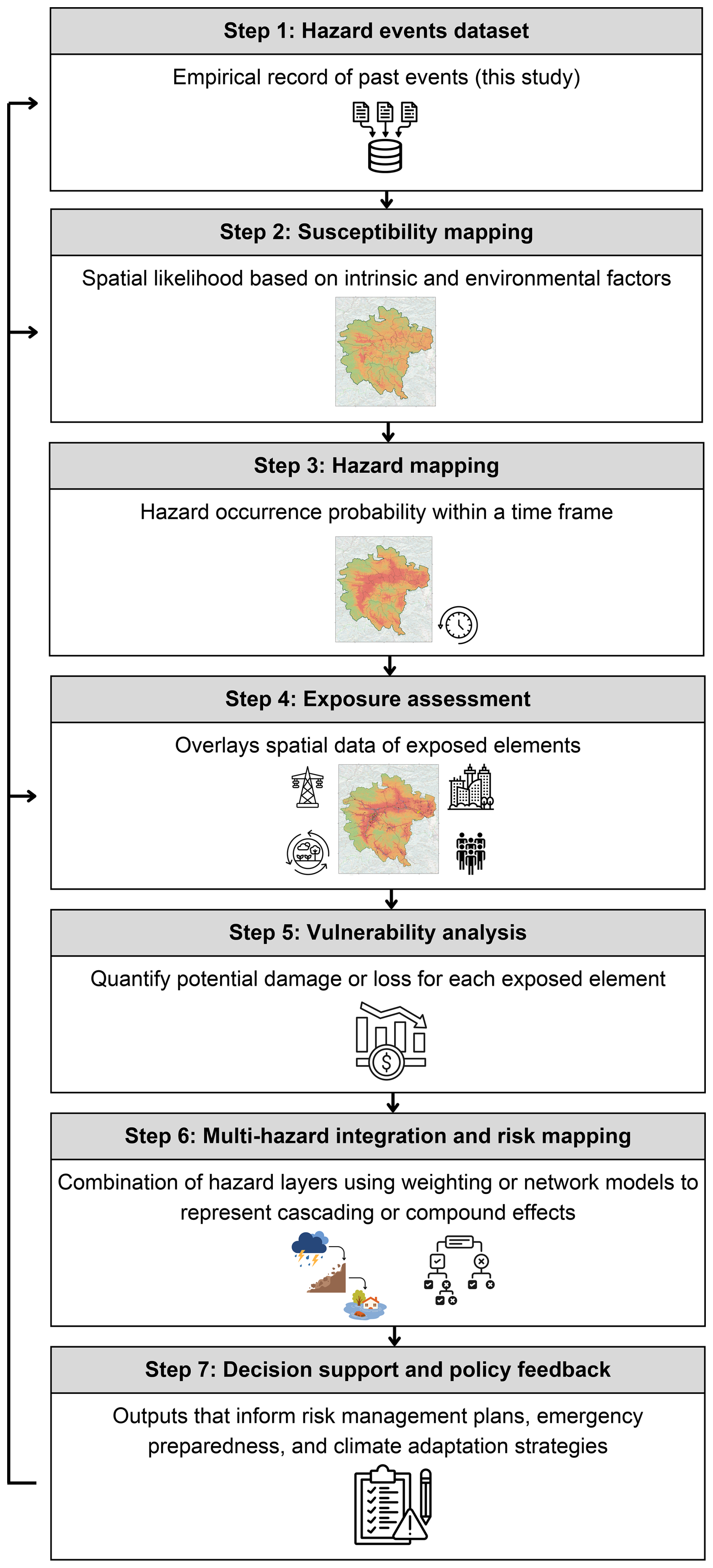
Figure 8General workflow for an integrated multi-hazard risk assessment. Each step is represented by rectangular boxes linked by arrows. Icons in the chart symbolize datasets, GIS analyses, and feedback loops to policy actors.
5.3 Implications for regional risk management
For the Regional County Council and SIGMA, the dataset provides the first integrated evidence base of recorded natural-hazard events in Garrotxa. Previously, disparate archives hindered coordinated action. Now, cross-hazard visualization reveals which municipalities face overlapping threats. For example, the overlap of flood and landslide records along the Fluvià River underscores the need for joint hydraulic–geotechnical planning, while patterns linking wildfire records to periods of limited precipitation and elevated temperatures inform vegetation-management priorities.
To maximize long-term utility, the dataset should be synchronized with existing real-time monitoring networks (meteorological and seismic) so that new events feed automatically into the dataset. Developing an open-data API would further enable public transparency and early-warning integration.
Beyond Garrotxa, this initiative demonstrates a replicable governance model: a partnership between research institutions and local administrations that aligns with the National Plan for Adaptation to Climate Change (2021–2030) in Spain.
5.4 Challenges of data collection and processing
One of the main challenges encountered during dataset compilation was the scarcity of pre-inventoried data from official records, particularly for geological hazards such as landslides, rockfalls, and ground subsidences. Consequently, alternative sources, including historical newspapers and input from local experts, had to be consulted. Earthquakes were the only hazard type for which all relevant information could be retrieved from existing inventories, due to the presence of an established seismic monitoring network in the region.
Gathering information beyond official inventories proved time-consuming, but enabled the identification of additional events and improved data completeness. The integration of data from different institutional sources also required methodological adjustments, as similar datasets were often stored using different formats that had to be standardized before inclusion in the dataset.
Another challenge arose from the varying nature of the consulted sources. While inventoried datasets generally provided structured and precise parameters, written or oral sources often contained incomplete or subjective information, requiring additional verification through aerial imagery or expert consultation.
Human influence also had to be considered for certain hazards, including wildfires, floods, rockfalls, and landslides. This highlights the importance of accounting for human–environment interactions in hazard datasets. Finally, the largely manual nature of the data collection process underscores the need for future automation, for example through tools capable of extracting structured information from digitized archives or other semi-structured sources.
In terms of scalability, we believe that the approach presented here could be adapted to regions with characteristics similar to Garrotxa, as well as to other geographical contexts. Because hazards are recorded individually, the dataset structure can be readily extended to additional hazard types or adapted to different regional settings. However, the transferability of this approach may be constrained by data availability and by the heterogeneity of existing data sources and formats.
5.5 Main limitations of this study
The scope of this paper is primarily limited to the presentation of the natural hazard dataset, which represents a foundational step toward broader multi-hazard risk assessment. In addition, a simple exploratory analysis is provided to illustrate how the dataset may be applied in multi-hazard investigations; however, this example is intended for demonstration purposes only and does not constitute a comprehensive framework for analyzing hazard interrelationships.
The dataset currently includes events related to six types of natural hazards. Although these hazards were selected based on their relevance to the study area and the availability of reliable information, the exclusion of other hazards may limit the scope of future multi-hazard analyses.
The time span covered by the dataset (1900–2023) also introduces limitations. Some significant events, or even entire hazard types with longer recurrence intervals, such as volcanic activity, may not be represented. Consequently, the available record may not fully capture long-term hazard dynamics, particularly for rare but high-impact events.
Finally, no formal quantification of uncertainty has yet been conducted to assess the quality of the resulting dataset, particularly with respect to reliability, validity, and provenance (Koedel et al., 2022).
This study provides the first integrated dataset compiling documented occurrences of earthquakes, landslides, wildfires, rockfalls, floods, and ground subsidences affecting the Garrotxa region between 1900 and 2023. By integrating inventoried datasets, historical written sources, and citizen-science contributions, the study consolidates previously scattered information into a coherent and quality-controlled dataset. In total, 1049 events were documented, offering the most comprehensive reconstruction to date of natural-hazard occurrence in the region.
The exploratory analysis illustrates how the dataset can support the investigation of spatial and temporal relationships between hazards. By analysing event co-occurrence, the dataset highlights plausible interactions such as flood-induced slope failures, earthquake-related instabilities, and meteorological conditions associated with floods or wildfires. Although these observations are exploratory, they demonstrate the potential of the dataset to investigate cascading and compound hazard processes.
Comparison with national and international repositories shows that the Garrotxa dataset fills an important spatial and thematic gap between global disaster databases and local records. While large-scale repositories primarily document major disasters at national or continental scales, this dataset captures events across all magnitudes and provides municipality-level spatial resolution, incorporating locally validated information often absent from broader inventories.
Overall, the dataset constitutes both a regional data resource and a methodological reference for compiling and validating heterogeneous hazard information. The proposed workflow illustrates how diverse historical, institutional, and citizen-science data can be systematically integrated, representing a first step toward data-driven multi-hazard risk assessment and offering a methodological basis that can inform similar efforts in other regions.
The historical record of natural hazard events occurred in the Garrotxa region (Catalonia, Spain) from 1900 until 2023 is publicly available at: https://doi.org/10.20350/DIGITALCSIC/17415 (Lagresa et al., 2025).
The supplement related to this article is available online at https://doi.org/10.5194/nhess-26-3327-2026-supplement.
AL: Formal analysis, Investigation, Methodology, Visualization, Writing–original draft, Writing–review & editing. MLS: Conceptualization, Investigation, Methodology, Supervision, Writing–original draft, Writing–review & editing. ISP: Project administration, Writing–original draft, Writing–review & editing. MMS: Data curation, Formal analysis, Investigation, Methodology, Software, Writing–original draft. JME: Data curation, Formal analysis, Investigation, Methodology, Software. MJL: Funding acquisition, Project administration, Supervision. AO: Resources, Supervision. LP: Conceptualization, Funding acquisition, Investigation, Resources, Supervision, Writing–original draft. JM: Conceptualization, Resources, Supervision, Writing–review & editing.
The contact author has declared that none of the authors has any competing interests.
Publisher's note: Copernicus Publications remains neutral with regard to jurisdictional claims made in the text, published maps, institutional affiliations, or any other geographical representation in this paper. The authors bear the ultimate responsibility for providing appropriate place names. Views expressed in the text are those of the authors and do not necessarily reflect the views of the publisher.
This article is part of the special issue “Methodological innovations for the analysis and management of compound risk and multi-risk, including climate-related and geophysical hazards (NHESS/ESD/ESSD/GC/HESS inter-journal SI)”. It is not associated with a conference.
We are grateful to everyone who shared data and information for this study, as well as to all the participants in the citizen science workshops for sharing their local knowledge and contributing to the identification of natural hazard events in La Garrotxa. We also thank the model developers for their valuable expertise in identifying the main variables commonly used to characterize the selected natural hazards. Finally, we thank the anonymous reviewers and the editor for their constructive comments and suggestions, which helped improve this manuscript.
This work is part of the GarMultiRisk project (grant no. 670489), funded by the Biodiversity Foundation of Spanish Ministry for the Ecological Transition and the Demographic Challenge, through the Grants call in competition regime for the execution of projects that contribute to implementing the National Plan for Adaptation to Climate Change (2021–2030).
The article processing charges for this open-access publication were covered by the CSIC Open Access Publication Support Initiative through its Unit of Information Resources for Research (URICI).
This paper was edited by Robert Sakic Trogrlic and reviewed by two anonymous referees.
Abellán, A., Vilaplana, J. M., Calvet, J., García-Sellés, D., and Asensio, E.: Rockfall monitoring by Terrestrial Laser Scanning – case study of the basaltic rock face at Castellfollit de la Roca (Catalonia, Spain), Nat. Hazards Earth Syst. Sci., 11, 829–841, https://doi.org/10.5194/nhess-11-829-2011, 2011.
Agència Catalana de l'Aigua (ACA): Visor zones inundables Catalunya, Generalitat de Catalunya, https://sig.gencat.cat/visors/VISOR_ACA.html?background=icgc_mapa_estandard&bg_transp=1&BBOX=73119,4476350,664228,4736553&layers=AIGUA_LI500,AIGUA_LI100,AIGUA_LI10,AIGUA_TRAMS_ARPSI,AIGUA_ZFP,AIGUA_ZP,AIGUA_DPH,AIGUA_ZS&styles=0,0,0,0,0,0,0,0&transparency=1,1,1,1,1,1,1,1, last access: 15 December 2024.
Agencia Estatal de Meteorología (AEMET): AEMET Open Data, https://opendata.aemet.es/centrodedescargas/inicio, last access: 18 June 2026.
Ajuntament de Girona: Premsa digitalitzada, Servei de Gestió Documental, Arxius i Publicacions, https://www.girona.cat/sgdap/cat/premsa.php, last access: 15 December 2024.
Ajuntament d'Olot: Pla de Protecció Civil Municipal d'Olot (PPCM) Manual d'Actuació Per Sismes (Sismicat), https://es.scribd.com/document/713716729/SISMICAT-OLOT-2006 (last access: 5 June 2024), 2006.
Ajuntament d'Olot: Document Únic de Protecció Civil Municipal d'Olot, https://www.olot.cat/files/doc7814/duprocim-olot-copiapublica-signat.pdf (last access: 2 March 2024), 2022.
Barriendos, M., Gil-Guirado, S., Pino, D., Tuset, J., Pérez-Morales, A., Alberola, A., Costa, J., Balasch, J. C., Castelltort, X., Mazón, J., and Ruiz-Bellet, J. L.: Climatic and social factors behind the Spanish Mediterranean flood event chronologies from documentary sources (14th–20th centuries), Global Planet. Change, 182, 102997, https://doi.org/10.1016/j.gloplacha.2019.102997, 2019.
Bartolini, S., Bolós, X., Martí, J., Riera-Pedra, E. and Planagumà, L.: Hazard assessment at the Quaternary La Garrotxa Volcanic Field (NE Iberia), Nat. Hazards, 78, 1349–1367, https://doi.org/10.1007/s11069-015-1774-y, 2015.
Bassols, E. and Calm, E.: Cronologia dels principals esdeveniments en relació a l'estabilitat de la cinglera basàltica de castellfollit de la roca, Despreniments, estudis i treballs i informes preceptius, Generalitat de Catalunya, https://parcsnaturals.gencat.cat/web/.content/Xarxa-de-parcs/garrotxa/coneix-nostra-feina/centre-documentacio/estudis/sols-geologia/estudi-caigudes-blocs-cinglera-basal-castellfollit/Cronologia-principals-fets-relacionats-cinglera-Castellfollit-de-la-Roca_web.pdf (last access: 7 April 2024), 2018.
Bisquert, A., Mainieri, R., Carladous, S., Robert, Y., Giacona, F., Verry, P., and Eckert, N.: The RTM Event Database for Understanding Natural Hazards in Mountainous Regions: The Example of the Isere Department (France), J. Alp. Res., 113, https://doi.org/10.4000/137kg, 2025.
Bladé, E., Cea, L., Corestein, G., Escolano, E., Puertas, J., Vázquez-Cendón, E., Dolz, J., and Coll, A.: Iber: herramienta de simulación numérica del flujo en ríos, Rev. Int. Metod. Numer., 30, 1–10, https://doi.org/10.1016/j.rimni.2012.07.004, 2014.
Bolós, X., Martí, J., Becerril, L., Planagumà, L., Grosse, P., and Barde-Cabusson, S.: Volcano-structural analysis of La Garrotxa Volcanic Field (NE Iberia): Implications for the plumbing system, Tectonophysics, 642, 58–70, https://doi.org/10.1016/j.tecto.2014.12.013, 2015
Calder, E. S., Wagner, K., and Ogburn, S. E.: Volcanic hazard maps, in: Global Volcanic Hazards and Risk, edited by: Loughlin, S. C., Sparks, R. S. J., Brown, S. K., Jenkins, S. F., and Vye-Brown, C., Cambridge Univ. Press, Cambridge, 335–341, https://doi.org/10.1017/CBO9781316276273.022, 2015.
Center for Emergency Management and Homeland Security (CEMHS): Spatial Hazard Events and Losses Database for the United States (SHELDUS), https://sheldus.asu.edu/login, last access: 15 December 2025.
Centre for Research on the Epidemiology of Disasters (CRED): EM-DAT: The Emergency Events Database, https://www.emdat.be/, last access: 15 December 2025.
Consell Comarcal de la Garrotxa: Pla de Prevenció d'Incendis Forestals (PPIF) de la Comarca de la Garrotxa, https://www.consorcisigma.org/wp-content/uploads/2021/05/Pla-incendis.pdf (last access: 20 June 2025), 2021.
Consorci de Medi Ambient i Salut Pública (SIGMA): Pla de Gestió del risc d'inundacions a la comarca de la Garrotxa, https://www.consorcisigma.org/wp-content/uploads/2019/03/Pla-Inundacions.pdf (last access: 20 June 2025), 2017.
Consorci de Medi Ambient i Salut Pública (SIGMA): Observatori per a la Sostenibilitat Territorial de la Garrotxa, https://www.consorcisigma.org/wp-content/uploads/2023/10/OBSERVATORI-2023.pdf (last access: 8 June 2024), 2023.
Copons, R.: El risc d'esllavissades a Catalunya, Consell Assessor per al Desenvolupament Sostenible (CADS), https://cads.gencat.cat/web/.content/Documents/Publicacions/el_risc_desllavissades_a_catalunya.pdf (last access: 20 June 2025), 2008a.
Copons, R.: El risc d'esfondraments i subsidències a catalunya, Consell Assessor per al Desenvolupament Sostenible (CADS), https://cads.gencat.cat/web/.content/Documents/Publicacions/El-risc-desfondraments-i-subsidencies-a-Catalunya.pdf (last access: 20 June 2025), 2008b.
Cortès, M., Turco, M., Ward, P., Sánchez-Espigares, J. A., Alfieri, L., and Llasat, M. C.: Changes in flood damage with global warming on the eastern coast of Spain, Nat. Hazards Earth Syst. Sci., 19, 2855–2877, https://doi.org/10.5194/nhess-19-2855-2019, 2019.
Dades Obertes Catalunya: Incendis forestals a Catalunya. Anys 2011-2023, Generalitat de Catalunya, https://analisi.transparenciacatalunya.cat/Medi-Rural-Pesca/Incendis-forestals-a-Catalunya-Anys-2011-2023/bks7-dkfd/data_preview (last access: 20 June 2025), 2023.
Departament d'Interior i Seguretat Pública: Pla especial per inundacions a Catalunya (INUNCAT), Generalitat de Catalunya, https://interior.gencat.cat/ca/arees_dactuacio/proteccio_civil/plans-proteccio-civil/plans-especials/inuncat/ (last access: 20 June 2025), 2015.
Departament d'Interior i Seguretat Pública: Pla especial d'emergències sísmiques a Catalunya (SISMICAT), Generalitat de Catalunya, https://interior.gencat.cat/ca/arees_dactuacio/proteccio_civil/plans-proteccio-civil/plans-especials/sismicat/ (last access: 20 June 2025), 2021.
Departament d'Interior i Seguretat Pública: Pla especial d'emergències per incendis forestals de Catalunya (INFOCAT), Generalitat de Catalunya, https://interior.gencat.cat/ca/arees_dactuacio/proteccio_civil/plans-proteccio-civil/plans-especials/infocat/index.html (last access: 21 June 2025), 2024.
de Ruiter, M. C., Couasnon, A., van den Homberg, M. J. C., Daniell, J. E., Gill, J. C., and Ward, P. J.: Why we can no longer ignore consecutive disasters, Earth's Future, 8, https://doi.org/10.1029/2019EF001425, 2020.
Disaster Risk Management Knowledge Centre (DRMKC): Risk Data Hub, https://drmkc.jrc.ec.europa.eu/risk-data-hub, last access: 15 December 2025.
Duane, A., Castellnou, M. and Brotons, L.: Towards a comprehensive look at global drivers of novel extreme wildfire events, Clim. Change, 165, 43, https://doi.org/10.1007/s10584-021-03066-4, 2021.
Escuer, J.: El risc d'inundacions a Catalunya, Consell Assessor per al Desenvolupament Sostenible (CADS), https://cads.gencat.cat/web/.content/Documents/Publicacions/el_risc_dinundacions_a_catalunya.pdf (last access: 20 June 2025), 2008.
Fábregat, I.: Estudio de dolinas en el karst evaporítico epigénico e hipogénico de la garrotxa (ne de españa) mediante cartografía geomorfológica, georadar y tomografía eléctrica de resistividades, PhD Thesis, https://dialnet.unirioja.es/servlet/tesis?codigo=265807 (last access: 4 March 2024), 2020.
Fábregat, I., Gutiérrez, F., Roqué, C., Zarroca, M., Linares, R., Comas, X., Guerrero, J., and Carbonel, D.: Subsidence mechanisms and sedimentation in alluvial sinkholes inferred from trenching and ground penetrating radar (GPR). Implications for subsidence and flooding hazard assessment, Quatern. Int., 525, 1–15, https://doi.org/10.1016/j.quaint.2019.09.008, 2019.
GarrotxaDigital: Es preveu que la Garrotxa sigui la segona comarca de Catalunya que més creixerà en nombre relatiu d'habitants, https://www.garrotxadigital.cat/noticia/181144/es-preveu-que-la-garrotxa-sigui-la-segona-comarca-de-catalunya-que-mes-creixera-amb-nombre-relatiu-dhabitants, last access: 26 April 2022.
Garrotxa Tourism: Territory and Nature, https://en.turismegarrotxa.com/la-garrotxa/territory-and-nature/, last access: 9 July 2025.
Generalitat de Catalunya (Gencat): Somos 8 millones, https://web.gencat.cat/es/ciutadania/actualitat#:~:text=De los 8 millones de,en la demarcación de Barcelona, last access: 3 November 2023.
Gill, J. C. and Malamud, B. D.: Reviewing and visualizing the interactions of natural hazards, Rev. Geophys., 52, 680–722, https://doi.org/10.1002/2013RG000445, 2014.
Gill, J. C., Duncan, M., Ciurean, R., Smale, L., Stuparu, D., Schlumberger, J., de Ruiter, M., Tiggeloven, T., Torresan, S., Gottardo, S., Mysiak, J., Harris, R., Petrescu, E.-C., Girard, T., Khazai, B., Claassen, J., Dai, R., Champion, A., Daloz, A. S., Blanco Cipollone, F., Campillo Torres, C., Palomino Antolin, I., Ferrario, D., Tatman, S., Tijssen, A., Vaidya, S., Adesiyun, A., Goger, T., Angiuli, A., Audren, M., Machado, M., Hochrainer-Stigler, S., Šakić Trogrlić, R., Daniell, J., Bulder, B., Krishna Swamy, S., Wiggelinkhuizen, E.-J., Díaz Pacheco, J., López Díez, A., Mendoza Jiménez, J., Padrón-Fumero, N., Appulo, L., Orth, R., Sillmann, J., and Ward, P.: MYRIAD-EU D1.2 Handbook of Multi-hazard, Multi-Risk Definitions and Concepts, Zenodo, https://doi.org/10.5281/zenodo.7135138, 2022.
Guo, Z., Torra, O., Hürlimann, M., Abancó, C., and Medina, V.: FSLAM: A QGIS plugin for fast regional susceptibility assessment of rainfall-induced landslides, Environ. Model. Softw., 150, https://doi.org/10.1016/j.envsoft.2022.105354, 2022.
Gutiérrez, F., Fábregat, I., Roqué, C., Carbonel, D., Guerrero, J., García-Hermoso, F., Zarroca, M., and Linares, R.: Sinkholes and caves related to evaporite dissolution in a stratigraphically and structurally complex setting, Fluvià Valley, eastern Spanish Pyrenees, Geological, geomorphological and environmental implications, Geomorphology, 267, 76–97, https://doi.org/10.1016/j.geomorph.2016.05.018, 2016.
Guzzetti, F., Peruccacci, S., Rossi, M., and Stark, C.: Rainfall thresholds for the initiation of landslides in Central and Southern Europe, Meteorol. Atmos. Phys., 98, 239–267, https://doi.org/10.1007/s00703-007-0262-7, 2007.
Hewitt, K. and Burton, I.: The Hazardousness of a Place: A Regional Ecology of Damaging Events, University of Toronto Press, https://doi.org/10.2307/213252, 1971.
Institut Cartogràfic i Geològic de Catalunya (ICGC): Mapa geológico comarcal de la Garrotxa 1:50.000, https://datacloud.icgc.cat/datacloud/descarregues-web/bd/mapes/igc_MGCom50M_19_v1g.pdf (last access: 19 June 2025), 2006.
Institut Cartogràfic i Geològic de Catalunya (ICGC): Mapa de mesozonació sísmica de Catalunya 1: 250.000, Generalitat de Catalunya, https://www.icgc.cat/ca/Geoinformacio-i-mapes/Dades-i-productes/Geoinformacio-geologica-i-geofisica/Cartografia-sismologica/Mapa-de-mesozonacio-sismica-de-Catalunya-1250000 (last access: 19 June 2025), 2020.
Institut Cartogràfic i Geològic de Catalunya (ICGC): GT VI. Mapa para la prevención de los riesgos geológicos 1:25.000, Generalitat de Catalunya, https://www.icgc.cat/es/Geoinformacion-y-mapas/Datos-y-productos/Geoinformacion-geologica-y-geofisica/Cartografia-geologica/GT-VI-Mapa-para-la-prevencion-de-los-riesgos-geologicos-125000, last access: 18 June 2026.
Institut d'Estadística de Catalunya (Idescat): El municipi en xifres, Olot (Garrotxa), Generalitat de Catalunya, https://www.idescat.cat/emex/?id=171143 (last access: 16 February 2025), 2025a.
Institut d'Estadística de Catalunya (Idescat): El municipi en xifres, La Vall d'en Bas (Garrotxa), Generalitat de Catalunya, https://www.idescat.cat/emex/?id=172076 (last access: 16 February 2025), 2025b.
Instituto Geográfico Nacional (IGN): Actualización de mapas de peligrosidad sísmica de España 2012, Centro Nacional de Información Geográfica (CNIG), ISBN 978-84-416-2685-0, https://www.ign.es/resources/acercaDe/libDigPub/ActualizacionMapasPeligrosidadSismica2012.pdf (last access: 19 June 2025), 2017.
Janeras, M., Lantada, N., Núñez-Andrés, M. A., Hantz, D., Pedraza, O., Cornejo, R., Guinau, M., García-Sellés, D., Blanco, L., Gili, J. A., and Palau, J.: Rockfall Magnitude-Frequency Relationship Based on Multi-Source Data from Monitoring and Inventory, Remote Sens., 15, 1981, https://doi.org/10.3390/rs15081981, 2023.
Jiménez, M. J. and García, M.: El risc de terratrèmols a Catalunya, Consell Assessor per al Desenvolupament Sostenible (CADS), https://cads.gencat.cat/web/.content/Documents/Publicacions/el_risc_de_terratrmols_a_catalunya.pdf (last access: 19 June 2025), 2008.
Kappes, M. S., Keiler, M., von Elverfeldt, K., and Glade, T.: Challenges of analyzing multi-hazard risk: a review, Nat. Hazards, 64, 1925–1958, https://doi.org/10.1007/s11069-012-0294-2, 2012.
Koedel, U., Schuetze, C., Fischer, P., Bussmann, I., Sauer, P. K., Nixdorf, E., Kalbacher, T., Wichert, V., Rechid, D., Bouwer, L. M., and Dietrich, P.: Challenges in the Evaluation of Observational Data Trustworthiness From a Data Producers Viewpoint (FAIR+), Front. Environ. Sci., 9, https://doi.org/10.3389/fenvs.2021.772666, 2022.
Lagresa, A., López Saavedra, M., Jiménez-Llobet, M., Martí, J., Martínez-Sepúlveda, M., Ocaña, A., Planagumà, L., and Schneider-Pérez, I.: Historical record of natural hazard events occurred in the Garrotxa region (Catalonia, Spain) from 1900 until 2023, Digital.CSIC [data set], https://doi.org/10.20350/DIGITALCSIC/17415, 2025.
Lee, R., White, C. J., Adnan, M. S. G., Douglas, J., Mahecha, M. D., O'Loughlin, F. E., Patelli, E., Ramos, A. M., Roberts, M. J., Martius, O., Tubaldi, E., van den Hurk, B., Ward, P. J., and Zscheischler, J.: Reclassifying historical disasters: From single to multi-hazards, Sci. Total Environ., 912, https://doi.org/10.1016/j.scitotenv.2023.169120, 2024.
Lindell, M. K.: Improving Hazard Map Comprehension for Protective Action Decision Making, Front. Comput. Sci., 2, 27, https://doi.org/10.3389/fcomp.2020.00027, 2020.
Llasat, M. C.: Floods evolution in the Mediterranean region in a context of climate and environmental change, Cuadernos de Investigación Geográfica, 47, 13–32, https://doi.org/10.18172/cig.4897, 2021.
Llasat, M. C., Llasat-Botija, M., Pardo, E., and Esbrí, L.: Base de dades d'inundacions i Visor AGORA, https://experience.arcgis.com/experience/484172e12fae4cbb934441203ee04e36/#data_s=id:dataSource_1-1804c92b61d-layer-10-1804c925200-layer-4:671 (last access: 15 September 2024), 2022.
López-Saavedra, M. and Martí, J.: Reviewing the multi-hazard concept, Application to volcanic islands, Earth-Sci. Rev., 236, 104286, https://doi.org/10.1016/j.earscirev.2022.104286, 2023.
MacPherson-Krutsky, C. C., Brand, B. D., and Lindell, M. K.: Does Updating Natural Hazard Maps to Reflect Best Practices Increase Viewer Comprehension of Risk?, Int. J. Disast. Risk Re., 46, 101487, https://doi.org/10.1016/j.ijdrr.2020.101487, 2020.
Martí, J., Bolós, X., and Plagumà, L.: Geological setting of La Garrotxa Volcanic Field, in: La Garrotxa Volcanic Field: Example of sustainable volcanic landscape management, edited by: Martí, J. and Planagumà, L., Springer Geoheritage, Geoparks and Geotourism Conservation and Management Series, https://doi.org/10.1007/978-3-319-42080-6_2, 2016.
Martí, J., Planagumà, L., Geyer, A., Canal, E., and Pedrazzi, D.: Complex interaction between Strombolian and phreatomagmatic eruptions in the Quaternary monogenetic volcanism of the Catalan Volcanic Zone (NE of Spain), J. Volcanol. Geoth. Res., 201, 178–193, https://doi.org/10.1016/j.jvolgeores.2010.12.009, 2011.
Martí, J., Ricci, J., Planagumà, L., and Aguirre Díaz, G. J.: The Quaternary La Garrotxa volcanic field (NE of Iberia): A geochronological approach, Quaternary Sci. Adv., 17, https://doi.org/10.1016/j.qsa.2025.100267, 2025.
Martínez-Rius, A. Verges-Masip, J. Pujadas, J. Fleta, J., and Escuer-Sole, J.: Mapa geológico de España. 1:50.000. Hoja no. 257: Olot, Instituto Tecnológico Geominero de España, https://info.igme.es/cartografiadigital/datos/magna50/memorias/MMagna0257.pdf (last access: 13 June 2025), 1990.
Matas, G., Lantada, N., Corominas, J., Gili, J. A., Ruiz-Carulla, R., and Prades, A.: RockGIS: a GIS-based model for the analysis of fragmentation in rockfalls, Landslides, 14, 1565–1578, https://doi.org/10.1007/s10346-017-0818-7, 2017.
Maya, F. L. and Bendinelli, I.: Els incendis forestals a Catalunya de principis del segle XX a partir de fonts periodístiques, Orsis, Organismes i Sistemes: Revista de Botànica, Zoologia i Ecologia, 20, 83–91, https://ddd.uab.cat/pub/orsis/02134039v20/02134039v20p83.pdf, 2005.
Medina, V., Hürlimann, M., Guo, Z., Lloret, A., and Vaunat, J.: Fast physically-based model for rainfall-induced landslide susceptibility assessment at regional scale, Catena, 201, https://doi.org/10.1016/j.catena.2021.105213, 2021.
Nierga, J., Ginabreda, F., Núñez-Gubert, P., Valeri, X., Camps-Durban, E., Santaló, R., Estéban-Bochaca, R., Carbonés, M., Cerro, P., Carreres, J., Vilar, J., Artigas-Fontàs, B., Güibas-Guilana, E., Colomer, J., Juez, L., Perals, M., Pedrosa, C., Garcia, J., Freixa-Bosch, M.C., Remolins, J., Clara, J., Llagostera-Fernández, A., Sitjar-Serra, M., and Pagès, M.: Dossier: Aiguats, nevades, glaçades, Les Garrotxes (30), Editorial Gavarres, 29–83, https://issuu.com/grupgavarres/docs/gar30_iq_resum (last access: 13 June 2025), 2022.
Núñez-Murillo, A.: Simulación de escenarios sísmicos mediante un sistema de información geográfica para la península ibérica, las islas baleares y las islas canarias, considerando el efecto de sitio y las dimensiones y características de la fuente sísmica, PhD Thesis, https://doi.org/10.20868/UPM.thesis.47779, 2017.
Observatori Pirinenc del Canvi Climàtic (OPCC) and Comunitat de Treball dels Pirineus (CTP): Climate change in the Pyrenees: Impacts, vulnerabilities and adaptation Bases of knowledge for the future climate change adaptation strategy in the Pyrenees, ISBN 978-84-09-06268-3, https://www.opcc-ctp.org/sites/default/files/editor/opcc-informe-en-paginas.pdf (last access: 13 June 2025), 2018.
Pais, C., Carrasco, J., Martell, D. L., Weintraub, A., and Woodruff, D. L.: Cell2Fire: A Cell Based Forest Fire Growth Model, Cornell University, https://doi.org/10.48550/arXiv.1905.09317, 2019.
Palau, R. M., Berenguer, M., Hürlimann, M., and Sempere-Torres, D.: Implementation of hydrometeorological thresholds for regional landslide warning in Catalonia (NE Spain), Landslides, 20, 2039–2054, https://doi.org/10.1007/s10346-023-02094-8, 2023.
Palou, Ò., Puiguriguer, M., Boixadera, J., and Herrero, C.: Mapa de sòls 1:25.000 del Parc Natural de la Zona Volcànica de la Garrotxa i la plana agrícola de la Vall d'en Bas, Generalitat de Catalunya, https://parcsnaturals.gencat.cat/web/.content/Xarxa-de-parcs/garrotxa/coneix-nostra-feina/centre-documentacio/estudis/sols-geologia/mapa-sols/2010.pdf (last access: 14 June 2025), 2010.
Pausas, J. G. and Fernández-Muñoz, S.: Fire regime changes in the Western Mediterranean Basin: From fuel-limited to drought-driven fire regime, Clim. Change, 110, 215–226, https://doi.org/10.1007/s10584-011-0060-6, 2012.
Planagumà-Guàrdia, L., Martí-Molist, J., and Vila-Subirós, J.: Conservation of the Geological Heritage of Volcanic Fields: La Garrotxa Volcanic Zone Natural Park, Spain, Geoheritage, 14, 39, https://doi.org/10.1007/s12371-022-00677-w, 2022.
ReGira: Hemeroteca d'Olot, Diputació de Girona, https://www.bibgirona.cat/regira/municipis/olot/colleccions/hemeroteca-dolot, last access: 18 June 2026.
Revelles, J., Martí Molist, J., Burjachs, F., Finsinger, W., Iriarte, E., Mesquita-Joanes, F., Pla-Rabés, S., Planagumà, L., Rodrigo, M. A., Alcalde, G., and Saña, M.: Socio-ecological impact of monogenetic volcanism in the La Garrotxa Volcanic Field (NE Iberia), Sci. Rep., 13, 8168, https://doi.org/10.1038/s41598-023-35072-0, 2023.
Rodríguez-Peces, M. J., Román-Herrera, J. C., Peláez, J. A., Delgado, J., Tsige, M., Martino, S., and Garrido, J.: Unbiased logic-tree data for earthquake-induced landslide hazard maps for low-to-moderate magnitude events, Data Brief, 31, 105940, https://doi.org/10.1016/j.dib.2020.105940, 2020.
Secanell, R., Goula, X., Susagna, T., Fleta, J., and Roca, A.: Seismic hazard zonation of Catalonia, Spain, integrating random uncertainties, J. Seismol., 8, 25–40, https://doi.org/10.1023/B:JOSE.0000009516.91044.51, 2004.
Servei Meteorològic de Catalunya (METEOCAT): API de Dades Meteorològiques, https://apidocs.meteocat.gencat.cat/, last access: 18 June 2026.
Servei Meteorològic de Catalunya (METEOCAT): Butlletí anual d'indicadors climàtics, Generalitat de Catalunya, https://www.meteo.cat/wpweb/climatologia/butlletins-i-episodis-meteorologics/butlleti-anual-dindicadors-climatics/ (last access: 14 June 2025), 2024.
Sharma, S., Gomez, M., Keller, K., Nicholas, R. E., and Mejia, A.: Regional Flood Risk Projections under Climate Change, J. Hydrometerol., 22, 2259–2274, https://doi.org/10.1175/JHM-D-20-0238.1, 2021.
St. Denis, L. A., Short, K. C., McConnell, K., Cook, M. C., Mietkiewicz, N. P., Buckland, M., and Balch, J. K.: All-hazards dataset mined from the US National Incident Management System 1999–2020, Sci. Data, 10, 112, https://doi.org/10.1038/s41597-023-01955-0, 2023.
Tilloy, A., Malamud, B. D., Winter, H., and Joly-Laugel, A.: A review of quantification methodologies for multi-hazard interrelationships, Earth-Sci. Rev., 196, https://doi.org/10.1016/j.earscirev.2019.102881, 2019.
Turco, M., Marcos-Matamoros, R., Castro, X., Canyameras, E., and Llasat, M. C.: Seasonal prediction of climate-driven fire risk for decision-making and operational applications in a Mediterranean region, Sci. Total Environ., 676, 577–583, https://doi.org/10.1016/j.scitotenv.2019.04.296, 2019.
Turco, M., Rosa-Cánovas, J. J., Bedia, J., Jerez, S., Montávez, J. P., Llasat, M. C., and Provenzale, A.: Exacerbated fires in Mediterranean Europe due to anthropogenic warming projected with non-stationary climate-fire models, Nat. Commun., 9, 3821, https://doi.org/10.1038/s41467-018-06358-z, 2018.
Turisme Garrotxa: GLab: Demanda, http://dades.turismegarrotxa.com/portal/demanda/visualitzacio/#body (last access: 19 February 2025), 2023.
United Nations Office for Disaster Risk Reduction (UNDRR): Sendai framework for Disaster Risk Reduction 2015–2030, Third United Nations World Conference on Disaster Risk Reduction, Sendai, Miyagi, Japan, 14–18 March 2015, https://www.undrr.org/publication/sendai-framework-disaster-risk-reduction-2015-2030 (last access: 14 May 2024), 2015.
United Nations Office for Disaster Risk Reduction (UNDRR): The disaster risk reduction (DRR) glossary, https://www.undrr.org/drr-glossary/terminology (last access: 15 June 2025), 2016.
United Nations Office for Disaster Risk Reduction (UNDRR) & International Science Council (ISC): Hazard Information Profiles 2025-update, https://doi.org/10.24948/2025.05, 2025.
Varga, D., Subirós, J. V., Barriocanal, C., and Pujantell, J.: Landscape transformation under global environmental change in Mediterranean Mountains: Agrarian lands as a guarantee for maintaining their multifunctionality, Forests, 9, https://doi.org/10.3390/f9010027, 2018.
Vilaplana, J., Payàs, B., Copons, R., Guillén, J., Jiménez, M. J., García, M., Martí, J., Ribot, E., and Escuer-Solé, J.: RISKCAT Natural Risks in Catalonia Executive report, Consell Assessor per al Desenvolupament Sostenible (CADS), https://www.researchgate.net/publication/313426424_RISKCAT_Natural_Risks_in_Catalonia_Executive_report (last access: 11 June 2025), 2008.
Vilar, J.: Històries de l'Alta Garrotxa, 1st ed., Editorial Gavarres, ISBN 978-84-19292-01-8, 2022.
Vila-Subirós, J., Rodríguez-Carreras, R., Varga, D., Ribas, A., Úbeda, X., Asperó, F., Llausàs, A., and Outeiro, L.: Stakeholder perceptions of landscape changes in the Mediterranean Mountains of the north-eastern Iberian Peninsula, Land Degrad. Dev., 27, 1354–1365, https://doi.org/10.1002/ldr.2337, 2014.
Zscheischler, J., Martius, O., Westra, S., Bevacqua, E., Raymond, C., Horton, R. M., van den Hurk, B., AghaKouchak, A., Jézéquel, A., Mahecha, M. D., Maraun, D., Ramos, A. M., Ridder, N. N., Thiery, W., and Vignotto, E.: A typology of compound weather and climate events, Nat. Rev. Earth Environ., 1, 333–347, https://doi.org/10.1038/s43017-020-0060-z, 2020.