Articles | Volume 26, issue 7
https://doi.org/10.5194/nhess-26-3107-2026
© Author(s) 2026. This work is distributed under
the Creative Commons Attribution 4.0 License.
https://doi.org/10.5194/nhess-26-3107-2026
© Author(s) 2026. This work is distributed under
the Creative Commons Attribution 4.0 License.
Automated dock-based UAV systems for geohazard monitoring in mountainous terrain

Alexander Maschler
CORRESPONDING AUTHOR
Department of Civil Engineering and Environmental Sciences, Western Norway University of Applied Sciences, Sogndal, Norway
Sarah Langes
Department of Civil Engineering and Environmental Sciences, Western Norway University of Applied Sciences, Sogndal, Norway
Lukas Schild
Department of Civil Engineering and Environmental Sciences, Western Norway University of Applied Sciences, Sogndal, Norway
Thomas Scheiber
Department of Civil Engineering and Environmental Sciences, Western Norway University of Applied Sciences, Sogndal, Norway
Paula Snook
Department of Civil Engineering and Environmental Sciences, Western Norway University of Applied Sciences, Sogndal, Norway
Jacob Clement Yde
Department of Civil Engineering and Environmental Sciences, Western Norway University of Applied Sciences, Sogndal, Norway
Harald Zandler
Department of Geography and Regional Science, University of Graz, Graz, Austria
Ueli Sager
Remote Vision, Herisau, Switzerland
Related authors
No articles found.
Lukas Schild, Ascanio Rosi, and Filippo Catani
EGUsphere, https://doi.org/10.5194/egusphere-2026-1796, https://doi.org/10.5194/egusphere-2026-1796, 2026
This preprint is open for discussion and under review for Natural Hazards and Earth System Sciences (NHESS).
Short summary
Short summary
We developed a transparent machine learning model that forecasts rainfall-triggered landslides from satellite rain data. It matches the accuracy of complex models while staying easy to understand, and keeps missed warnings low. We also introduce simple visual thresholds to help decision-makers use the predictions. This is needed, for example, for Early Warning Systems, where it is extremely helpful to understand the models' predictions.
Lea Hartl, Jakob Abermann, Ayla Akgün, Giulia Bertolotti, Tobias Bolch, Svenja Conzelmann, Codrut-Andrei Diaconu, Iris Hansche, Anne Hartig, Anna Haut, Kay Helfricht, Bernhard Hynek, Marie Sophie Kaucher, Andreas Kellerer-Pirklbauer, Ann Christin Kogel, Julie Krippes, Marcela Violeta Lauria, Christoph Mayer, Jan-Christoph Otto, Rainer Prinz, Sina Prölß, Lorenzo Rieg, Lea Schönleber, Gabriele Schwaizer, Bernd Seiser, Martin Stocker-Waldhuber, Markus Strudl, Martin Verhounik, and Harald Zandler
EGUsphere, https://doi.org/10.5194/egusphere-2026-1241, https://doi.org/10.5194/egusphere-2026-1241, 2026
Short summary
Short summary
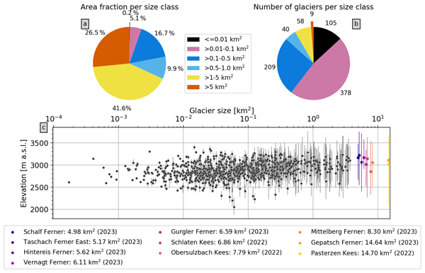
We mapped glacier outlines in Austria using recent, high resolution imagery. The resulting glacier inventory provides an update on glacier area in Austria in 2021-2023. More than 30% of glacier area was lost and 95 glaciers have disappeared since the mid-2000s. Glacier recession is accelerating and regular updates to glacier inventories are needed to understand downstream changes to the hydrological system, quantify glacier mass loss, and support planning and adaptation measures.
Henning Åkesson, Kamilla Hauknes Sjursen, Thomas Vikhamar Schuler, Thorben Dunse, Liss Marie Andreassen, Mette Kusk Gillespie, Benjamin Aubrey Robson, Thomas Schellenberger, and Jacob Clement Yde
The Cryosphere, 19, 5871–5902, https://doi.org/10.5194/tc-19-5871-2025, https://doi.org/10.5194/tc-19-5871-2025, 2025
Short summary
Short summary
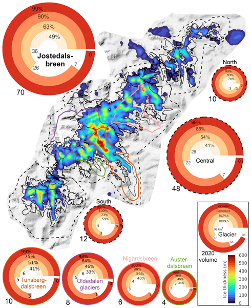
We model the historical and future evolution of the Jostedalsbreen ice cap in Norway, projecting substantial and largely irreversible mass loss for the 21st century, and that the ice cap will split into three parts. Further mass loss is in the pipeline, with a disappearance during the 22nd century under high emissions. Our study demonstrates an approach to model complex ice masses, highlights uncertainties due to precipitation, and calls for further research on long-term future glacier change.
Mette K. Gillespie, Liss M. Andreassen, Matthias Huss, Simon de Villiers, Kamilla H. Sjursen, Jostein Aasen, Jostein Bakke, Jan M. Cederstrøm, Hallgeir Elvehøy, Bjarne Kjøllmoen, Even Loe, Marte Meland, Kjetil Melvold, Sigurd D. Nerhus, Torgeir O. Røthe, Eivind W. N. Støren, Kåre Øst, and Jacob C. Yde
Earth Syst. Sci. Data, 16, 5799–5825, https://doi.org/10.5194/essd-16-5799-2024, https://doi.org/10.5194/essd-16-5799-2024, 2024
Short summary
Short summary
We present an extensive ice thickness dataset from Jostedalsbreen ice cap that will serve as a baseline for future studies of regional climate-induced change. Results show that Jostedalsbreen currently (~2020) has a maximum ice thickness of ~630 m, a mean ice thickness of 154 ± 22 m and an ice volume of 70.6 ±10.2 km3. Ice of less than 50 m thickness covers two narrow regions of Jostedalsbreen, and the ice cap is likely to separate into three parts in a warming climate.
Adam Emmer, Simon K. Allen, Mark Carey, Holger Frey, Christian Huggel, Oliver Korup, Martin Mergili, Ashim Sattar, Georg Veh, Thomas Y. Chen, Simon J. Cook, Mariana Correas-Gonzalez, Soumik Das, Alejandro Diaz Moreno, Fabian Drenkhan, Melanie Fischer, Walter W. Immerzeel, Eñaut Izagirre, Ramesh Chandra Joshi, Ioannis Kougkoulos, Riamsara Kuyakanon Knapp, Dongfeng Li, Ulfat Majeed, Stephanie Matti, Holly Moulton, Faezeh Nick, Valentine Piroton, Irfan Rashid, Masoom Reza, Anderson Ribeiro de Figueiredo, Christian Riveros, Finu Shrestha, Milan Shrestha, Jakob Steiner, Noah Walker-Crawford, Joanne L. Wood, and Jacob C. Yde
Nat. Hazards Earth Syst. Sci., 22, 3041–3061, https://doi.org/10.5194/nhess-22-3041-2022, https://doi.org/10.5194/nhess-22-3041-2022, 2022
Short summary
Short summary
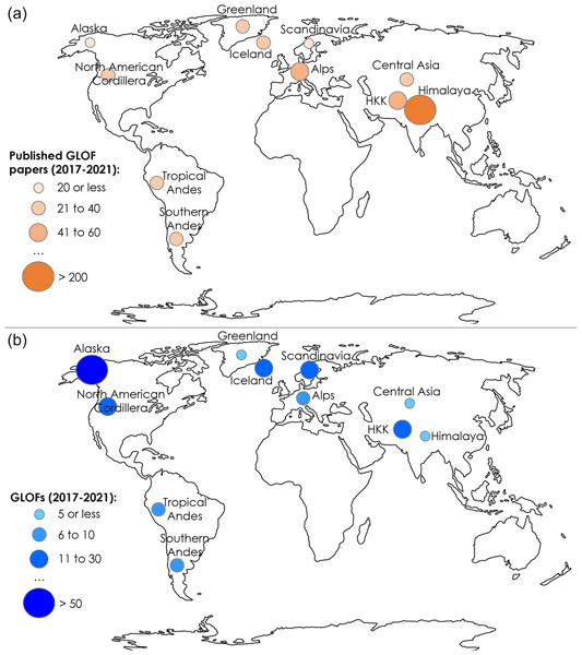
Glacial lake outburst floods (GLOFs) have attracted increased research attention recently. In this work, we review GLOF research papers published between 2017 and 2021 and complement the analysis with research community insights gained from the 2021 GLOF conference we organized. The transdisciplinary character of the conference together with broad geographical coverage allowed us to identify progress, trends and challenges in GLOF research and outline future research needs and directions.
Iwo Wieczorek, Mateusz Czesław Strzelecki, Łukasz Stachnik, Jacob Clement Yde, and Jakub Małecki
The Cryosphere Discuss., https://doi.org/10.5194/tc-2021-364, https://doi.org/10.5194/tc-2021-364, 2022
Manuscript not accepted for further review
Short summary
Short summary
Glacial lakes development around the World has been observed since the end of the Little Ice Age. The whole process is especially rapid in Arctic region what shows last researches. One of the last regions which still has not been covered by data about changes of glacial lakes is the Svalbard Archipelago (Norway). We used remote sensing materials and methods to provide information's about changes of glacial lakes and to show major activity of glacial lakes outburst floods.
Cited articles
Åkesson, H., Sjursen, K. H., Schuler, T. V., Dunse, T., Andreassen, L. M., Gillespie, M. K., Robson, B. A., Schellenberger, T., and Yde, J. C.: Recent history and future demise of Jostedalsbreen, the largest ice cap in mainland Europe, The Cryosphere, 19, 5871–5902, https://doi.org/10.5194/tc-19-5871-2025, 2025.
Andreassen, L. M., Elvehøy, H., and Kjøllmoen, B.: Glaciological investigations in Norway 2022 (Report No. 23/2023), Norwegian Water Resources and Energy Directorate, ISBN 978-82-410-2283-8, 2023.
Besl, P. J. and McKay, N. D.: A Method for Registration of 3-D Shapes, IEEE PAMI, 14, 239–256, https://doi.org/10.1109/34.121791, 1992.
Breien, H., Elverhøi, A., De Blasio, F., and Høeg, K.: Erosion and morphology of a debris flow caused by a glacial lake outburst flood, Western Norway, Landslides, 5, 271–280, https://doi.org/10.1007/s10346-008-0118-3, 2008.
Büntgen, U., Oppenheimer, C., Farinotti, D., Nahtz, T., and Esper, J.: The 2025 Blatten disaster in the Swiss Alps followed exceptional warming and highlights the vulnerability of people and heritage in glaciated landscapes, Commun. Earth Environ., 6, 994, https://doi.org/10.1038/S43247-025-02994-8, 2025.
Buskas, P. K.: Dynamics of the glacial lake at Flatbreen in Fjærland, Western Norway, and its role in the flood regime of the Tverrdøla catchment, MS thesis, Western Norway University of Applied Sciences, https://hdl.handle.net/11250/3158244 (last access: 30 June 2026), 2024.
Carrivick, J. L., Andreassen, L. M., Nesje, A., and Yde, J. C.: A reconstruction of Jostedalsbreen during the Little Ice Age and geometric changes to outlet glaciers since then, Quat. Sci. Rev., 284, 107501, https://doi.org/10.1016/j.quascirev.2022.107501, 2022.
Choi, S.-K., Ramirez, R. A., Lim, H.-H., and Kwon, T.-H.: Multi-source remote sensing-based landslide investigation: the case of the August 7, 2020, Gokseong landslide in South Korea, Sci. Rep., 14, 12048, https://doi.org/10.1038/s41598-024-59008-4, 2024.
Chudley, T. R., Christoffersen, P., Doyle, S. H., Abellan, A., and Snooke, N.: High-accuracy UAV photogrammetry of ice sheet dynamics with no ground control, The Cryosphere, 13, 955–968, https://doi.org/10.5194/tc-13-955-2019, 2019.
Clague, J. J., Huggel, C., Korup, O., and McGuire, B.: Climate change and hazardous processes in high mountains, Rev. Asoc. Geol. Argent., 69, 328–338, https://doi.org/10.5167/uzh-77920, 2012.
DJI: DJI Dock 2 – Technical Specifications, https://enterprise.dji.com/de/dock-2/specs (last access: 30 April 2026), 2024.
DJI: DJI Dock 3 – Technical Specifications, https://enterprise.dji.com/de/dock-3/specs (last access: 30 April 2026), 2025.
du Plessis, J. and Amoah, C.: Factors hindering the use of unmanned aerial vehicles for construction project monitoring, Discov. Appl. Sci., 7, 782, https://doi.org/10.1007/S42452-025-07414-2, 2025.
Dwivedi, R., Narayan, A. B., Tiwari, A., Dikshit, O., and Singh, A. K.: Multi-Temporal SAR Interferometry for Landslide Monitoring. Int. Arch. Photogramm. Remote Sens. Spatial Inf. Sci., XLI-B8, 55–58, https://doi.org/10.5194/isprs-archives-XLI-B8-55-2016, 2016.
European Union Aviation Safety Agency (EASA): EASA guidance document, https://www.easa.europa.eu/en/faq/116449 (last access: 10 April 2026), 2020.
Farinotti, D.,Huss,M., Jacquemart, M., Werder, M., Walden, J., Knutti, R., Seneviratne, S., Gagliardini, O., Schuler, T., Fischer, E., and Bresch, D.: Birchgletscher Fact Sheet, ETH Zurich Laboratory of Hydraulics, Hydrology and Glaciology VAW, 88028-VAW-2025–06d, 2025.
Fey, C. and Wichmann, V.: Long-range terrestrial laser scanning for geomorphological change detection in alpine terrain – handling uncertainties, Earth Surf. Process. Landf., 42, 789–802, https://doi.org/10.1002/esp.4022, 2017.
Fraser, B.: Learning from flood-alarm system's fate, EcoAméricas, https://cooperacionsuiza.pe/wp-content/uploads/2017/05/fraser_sat_carhuaz_ecoamericas17.pdf (last access: 25 June 2026), 2017.
Frodella, W., Salvatici, T., Pazzi, V., Morelli, S., and Fanti, R.: GB-InSAR monitoring of slope deformations in a mountainous area affected by debris flow events, Nat. Hazards Earth Syst. Sci., 17, 1779–1793, https://doi.org/10.5194/nhess-17-1779-2017, 2017.
Gerstner, R., Maschler, A., Schneider-Muntau, B., Agliardi, F., Avian, M., Frießenbichler, M., and Zangerl, C.: The critical role of fracture propagation in the evolution of extensive, structurally preconditioned rockslides, Eng. Geol., 358, 108359, https://doi.org/10.1016/j.enggeo.2025.108359, 2025.
Ghosh, S. (Ed.): Living on the Edge of Fragile Majesty: An Introductory Note on Emerging Risks, Hazards and Disasters in the Himalaya, in: The Himalaya Dilemma: Navigating Risk, Vulnerability, and Resilience in Geohazard-Prone Regions, Springer, Cham., Switzerland, 1–42, https://doi.org/10.1007/978-3-031-95083-4_1, 2025.
Gillespie, M. K., Andreassen, L. M., Huss, M., de Villiers, S., Sjursen, K. H., Aasen, J., Bakke, J., Cederstrøm, J. M., Elvehøy, H., Kjøllmoen, B., Loe, E., Meland, M., Melvold, K., Nerhus, S. D., Røthe, T. O., Støren, E. W. N., Øst, K., and Yde, J. C.: Ice thickness and bed topography of Jostedalsbreen ice cap, Norway, Earth Syst. Sci. Data, 16, 5799–5825, https://doi.org/10.5194/essd-16-5799-2024, 2024.
Groos, A. R., Bertschinger, T. J., Kummer, C. M., Erlwein, S., Munz, L., and Philipp, A.: The Potential of Low-Cost UAVs and Open-Source Photogrammetry Software for High-Resolution Monitoring of Alpine Glaciers: A Case Study from the Kanderfirn (Swiss Alps), Geosciences, 9, 356, https://doi.org/10.3390/geosciences9080356, 2019.
Haualand, K. F., Sauter, T., Abermann, J., de Villiers, S. D., Georgi, A., Goger, B., Dawson, I., Nerhus, S. D., Robson, B. A., Sjursen, K. H., Thomas, D. J., Thomaser, M., and Yde, J. C.: Meteorological Impact of Glacier Retreat and Proglacial Lake Temperature in Western Norway, J. Geophys. Res.-Atmos., 130, https://doi.org/10.1029/2024JD042715, 2025.
Hart, J. K., Baurley, N. R., Bonnie, A., Robson, B. A., Bragg, G., and Martinez, K.: Seasonal velocity patterns provide insights for the soft-bed subglacial hydrology continuum, Commun. Earth Environ. 6, 223, https://doi.org/10.1038/s43247-025-02198-0, 2025.
Heim, M.: Berggrunnskart ØYE 1517 II, M 1 : 50 000, Norges geologiske undersøkelse, https://doi.org/10.13140/RG.2.1.4366.4806, 2003.
Hermanns, R. L., Oppikofer, T., Anda, E., Blikra, L. H., Böhme, M., Bunkholt, H., Crosta, G. B., Dahle, H., Devoli, G., Fischer, L., Jaboyedoff, M., Loew, S., Sætre, S., and Yugsi Molina, F. X.: Hazard and risk classification for large unstable rock slopes in Norway, Italian Journal of Engineering Geology and Environment, 23–36, https://doi.org/10.4408/IJEGE.2013-06.B-22, 2013.
Hermans, T. D. G., Šakić Trogrlić, R., van den Homberg, M. J. C., Bailon, H., Sarku, R., and Mosurska, A.: Exploring the integration of local and scientific knowledge in early warning systems for disaster risk reduction: a review, Nat. Hazards, 114, 1125–1152, https://doi.org/10.1007/S11069-022-05468-8, 2022.
Hermle, D., Gaeta, M., Krautblatter, M., Mazzanti, P., and Keuschnig, M.: Performance Testing of Optical Flow Time Series Analyses Based on a Fast, High-Alpine Landslide, Remote Sens., 14, 455, https://doi.org/10.3390/rs14030455, 2022.
Hosseini, K., Zubareva, S., Hummelsberger, J., and Holst, C.: Improved 4D feature-based deformation tracking for high-resolution real-time landslide and slope deformation monitoring based on terrestrial laser scanning, Nat. Hazards, 122, 178, https://doi.org/10.1007/s11069-025-07939-0, 2026.
Huang, G., Du, S., and Wang, D.: Open Access Satellite Navigation GNSS techniques for real-time monitoring of landslides: a review, Satell. Navig., 4, 5, https://doi.org/10.1186/s43020-023-00095-5, 2023.
Huggel, C., Carey, M., Emmer, A., Frey, H., Walker-Crawford, N., and Wallimann-Helmer, I.: Anthropogenic climate change and glacier lake outburst flood risk: local and global drivers and responsibilities for the case of lake Palcacocha, Peru, Nat. Hazards Earth Syst. Sci., 20, 2175–2193, https://doi.org/10.5194/nhess-20-2175-2020, 2020.
Islam, N., Carrivick, J. L., Coulthard, T., Westoby, M., Dunning, S., and Gindraux, S.: A growing threat of multi-hazard cascades highlighted by the Birch Glacier collapse and Blatten landslide in the Swiss Alps, Geology Today, 41, 200–205, https://doi.org/10.1111/GTO.12526, 2025.
James, M. R., Robson, S., d'Oleire-Oltmanns, S., and Niethammer, U.: Optimising UAV topographic surveys processed with structure-from-motion: Ground control quality, quantity and bundle adjustment, Geomorphology, 280, 51–66, https://doi.org/10.1016/j.geomorph.2016.11.021, 2017.
Kerbl, B., Kopanas, G., Leimkuehler, T., and Drettakis, G.: 3D Gaussian Splatting for Real-Time Radiance Field Rendering, ACM Trans. Graph., 42, 1–14, https://doi.org/10.1145/3592433, 2023.
Klimeš, J., Novotný, J., Rapre, A. C., Balek, J., Zahradníček, P., Strozzi, T., Sana, H., Frey, H., René, M., Štěpánek, P., Meitner, J., and Junghardt, J.: Paraglacial Rock Slope Stability Under Changing Environmental Conditions, Safuna Lakes, Cordillera Blanca Peru, Front. Earth Sci., 9, https://doi.org/10.3389/feart.2021.607277, 2021.
Kothari, U. C. and Momayez, M.: Machine Learning: A Novel Approach to Predicting Slope Instabilities, Int. J. Geophys., 1–9, https://doi.org/10.1155/2018/4861254, 2018.
Kristensen, L., Czekirda, J., Penna, I., Etzelmüller, B., Nicolet, P., Pullarello, J. S., Blikra, L. H., Skrede, I., Oldani, S., and Abellan, A.: Movements, failure and climatic control of the Veslemannen rockslide, Western Norway, Landslides, 18, 1963–1980, https://doi.org/10.1007/s10346-020-01609-x, 2021.
Kroeger, T., Timofte, R., Dai, D., and Van Gool, L.: Fast Optical Flow using Dense Inverse Search, arXiv [preprint], https://doi.org/10.48550/arXiv.1603.03590, 2016.
Kromer, R. A., Abellán, A., Hutchinson, D. J., Lato, M., Chanut, M.-A., Dubois, L., and Jaboyedoff, M.: Automated terrestrial laser scanning with near-real-time change detection – monitoring of the Séchilienne landslide, Earth Surf. Dynam., 5, 293–310, https://doi.org/10.5194/esurf-5-293-2017, 2017.
Lague, D., Brodu, N., and Leroux, J.: Accurate 3D comparison of complex topography with terrestrial laser scanner: Application to the Rangitikei canyon (N-Z), ISPRS J. Photogramm. Remote Sens., 82, 10–26, https://doi.org/10.1016/J.ISPRSJPRS.2013.04.009, 2013.
Lelli, F., Mulas, M., Critelli, V., Fabbiani, C., Tondo, M., Aleotti, M., and Corsini, A.: Leveraging High-Frequency UAV–LiDAR Surveys to Monitor Earthflow Dynamics-The Baldiola Landslide Case Study, Remote Sens., 17, 2657, https://doi.org/10.3390/rs17152657, 2025.
Ma, Z. and Mei, G.: Deep learning for geological hazards analysis: Data, models, applications, and opportunities, Earth-Sci. Rev., 223, 103858, https://doi.org/10.1016/j.earscirev.2021.103858, 2021.
Maschler, A., Snook, P., Schild, L., Samnøy, S. F., Kristensen, L., Dahle, H., Aalbu, J. H., Henriksen, H., Nerhus, S. D., and Scheiber, T.: Multistage 54 000 m3 rockfall (Stampa, Western Norway): Insights from comprehensive monitoring and failure analysis, Landslides, 23, 851–869, https://doi.org/10.1007/s10346-025-02620-w, 2026a.
Maschler, A., Langes, S., Schild, L., Scheiber, T., Snook, P., Yde, J. C., Zandler, H., and Sager, U.: Code and Data for: Automated dock-based UAV systems for geohazard monitoring in mountainous terrain, V1, DataverseNO [data set], https://doi.org/10.18710/YARAKI, 2026b.
McMahon, C., Mora, O. E., and Starek, M. J.: Evaluating the Performance of sUAS Photogrammetry with PPK Positioning for Infrastructure Mapping, Drones, 5, 50, https://doi.org/10.3390/drones5020050, 2021.
Nex, F. and Remondino, F.: UAV for 3D mapping applications: a review, Appl. Geomat., 6, 1–15, https://doi.org/10.1007/s12518-013-0120-x, 2014.
OpenDroneMap Authors ODM: A command line toolkit to generate maps, point clouds, 3D models and DEMs from drone, balloon or kite images, OpenDroneMap/ODM GitHub [code], https://github.com/OpenDroneMap/ODM (last access: 24 May 2026), 2025.
Picarelli, L., Lacasse, S., and Ho, K. K. S.: The Impact of Climate Change on Landslide Hazard and Risk, in: Understanding and Reducing Landslide Disaster Risk, edited by: Sassa, K., Mikoš, M., Sassa, S., Bobrowsky, P. T., Takara, K., and Dang, K., WLF 2020. ICL Contribution to Landslide Disaster Risk Reduction, Springer, Cham, https://doi.org/10.1007/978-3-030-60196-6_6, 2021.
py4dgeo Development Core Team: py4dgeo: library for change analysis in 4D point clouds, GitHub [code], https://github.com/3dgeo-heidelberg/py4dgeo (last access: 24 May 2026), 2022.
Rossi, G., Tanteri, L., Tofani, V., Vannocci, P., Moretti, S., and Casagli, N.: Multitemporal UAV surveys for landslide mapping and characterization, Landslides, 15, 1045–1052, https://doi.org/10.1007/s10346-018-0978-0, 2018.
Santise, M., Fornari, M., Forlani, G., and Roncella, R.: Evaluation of DEM generation accuracy from UAS imagery, Int. Arch. Photogramm, Remote Sens. Spatial Inf. Sci., XL-5, 529–536, https://doi.org/10.5194/isprsarchives-XL-5-529-2014, 2014.
Schild, L., Scheiber, T., Snook, P., Maschler, A., and Arghandeh, R.: Exposing the potential of XAI-based causal discovery for analysing unstable rock slopes, Sci. Rep., https://doi.org/10.1038/s41598-026-48268-x, 2026.
Schlögl, M., Gutjahr, K., and Fuchs, S.: The challenge to use multi-temporal InSAR for landslide early warning, 112, 2913–2919, https://doi.org/10.1007/s11069-022-05289-9, 2022.
Shen, X., Cao, Y., Sui, B., Zhang, S., and Feng, D.: An automatic remote sensing image shadow compensation method utilizing reflectance differences and transfer learning, GISci. Remote Sens., 62, https://doi.org/10.1080/15481603.2025.2487334, 2025.
Stähli, M., Sättele, M., Huggel, C., McArdell, B. W., Lehmann, P., Van Herwijnen, A., Berne, A., Schleiss, M., Ferrari, A., Kos, A., Or, D., and Springman, S. M.: Monitoring and prediction in early warning systems for rapid mass movements, Nat. Hazards Earth Syst. Sci., 15, 905–917, https://doi.org/10.5194/nhess-15-905-2015, 2015.
Stoffel, M., Trappmann, D. G., Coullie, M. I., Ballesteros Cánovas, J. A., and Corona, C.: Rockfall from an increasingly unstable mountain slope driven by climate warming, Nat. Geosci., 17, 249–254, https://doi.org/10.1038/s41561-024-01390-9, 2024.
Stuart-Smith, R. F., Roe, G. H., Li, S., and Allen, M. R.: Increased outburst flood hazard from Lake Palcacocha due to human-induced glacier retreat, Nat. Geosci., 14, 85–90, https://doi.org/10.1038/s41561-021-00686-4, 2021.
Toffanin, P.: OpenDroneMap: The Missing Guide, 2nd edn., UAV4GEO, ISBN 979-8857908136, 2023.
Walliser Bote: Birchgletscher wird nach Abbruch von 40 000 Kubikmeter Eis genauer beobachtet, Walliser Bote, 29 December 1993, https://www.e-newspaperarchives.ch/?a=d&d=WAB19931229-01.2.59 (last access: 28 April 2026), 1993.
Walter, F., Hodel, E., Mannerfelt, E. S., Cook, K., Dietze, M., Estermann, L., Wenner, M., Farinotti, D., Fengler, M., Hammerschmidt, L., Hänsli, F., Hirschberg, J., McArdell, B., and Molnar, P.: Brief communication: An autonomous UAV for catchment-wide monitoring of a debris flow torrent, Nat. Hazards Earth Syst. Sci., 22, 4011–4018, https://doi.org/10.5194/nhess-22-4011-2022, 2022.
Wangensteen, B., Tønsberg, O. M., Kääb, A., Eiken, T., and Hagen, J. O.: Surface elevation change and high resolution surface velocities for advancing outlets of jostedalsbreen, Geogr. Ann. A, 88, 55–74, https://doi.org/10.1111/j.0435-3676.2006.00283.x, 2006.
World Meteorological Organization: Early warnings for all: The UN Global Early Warning Initiative for the implementation of climate adaptation, Executive action plan 2023–2027, WMO, Geneva, https://www.itu.int/en/ITU-D/Emergency-Telecommunications/Documents/2025/EW4All/Executive_Action_Plan_en.pdf (last access: 30 June 2026), 2022.
xDEM contributors: xDEM, Zenodo [code], https://doi.org/10.5281/zenodo.11204531, 2023.
Xiao, H., Jiang, N., Chen, X., Hao, M., and Zhou, J.: Slope deformation detection using subpixel offset tracking and an unsupervised learning technique based on unmanned aerial vehicle photogrammetry data, Geol. J., 58, 2342–2352, https://doi.org/10.1002/gj.4677, 2023.
Yang, D., Qiu, H., Quevedo, R. P., Liu, Y., and Glade, T.: Birchgletscher rock-ice avalanche burying the village of Blatten on 28 May 2025, Valais, Switzerland, Landslides, 23, 283–291, https://doi.org/10.1007/S10346-025-02656-Y, 2026.
Zandler, H., Abermann, J., Robson, B. A., Maschler, A., Scheiber, T., Carrivick, J. L., and Yde, J. C.: Deep learning outperforms existing algorithms in glacier surface velocity estimation with high-resolution data – the example of Austerdalsbreen, Norway, Front. Remote Sens., 6, https://doi.org/10.3389/frsen.2025.1586933, 2025.
Zhong, Y., Allen, S., Li, D., Corona, C., Zheng, G., Liu, Q., and Stoffel, M.: Unravelling driving conditions of rock and ice avalanches and resulting cascading processes in High Mountain Asia, Landslides, 22, 989–1001, https://doi.org/10.1007/s10346-024-02421-7, 2025.
Short summary
Geohazards occur more often and at larger scale due to climate change. In this study, we used for the first time automated drone docks to monitor geohazards at 3 different sites in Norway and Switzerland. We present a monitoring workflow for automated Uncrewed Aerial Vehicle operations which can produce frequent, detailed maps showing surface change and displacement. Our results show how this approach can improve future hazard monitoring and early warning and help to protect communities at risk.
Geohazards occur more often and at larger scale due to climate change. In this study, we used...
Altmetrics
Final-revised paper
Preprint