
Articles | Volume 26, issue 5
https://doi.org/10.5194/nhess-26-2415-2026
© Author(s) 2026. This work is distributed under
the Creative Commons Attribution 4.0 License.
the Creative Commons Attribution 4.0 License.
https://doi.org/10.5194/nhess-26-2415-2026
© Author(s) 2026. This work is distributed under
the Creative Commons Attribution 4.0 License.
the Creative Commons Attribution 4.0 License.
Research article
| Highlight paper
| 
29 May 2026
Research article | Highlight paper |
| 29 May 2026
| 29 May 2026
The TSUSY Database: a global database of historical tsunami events and a tsunami-occurrence criterion based on historical earthquakes
David Galán Pérez
CORRESPONDING AUTHOR

IHCantabria – Instituto de Hidráulica Ambiental de la Universidad de Cantabria, Santander, Spain
Iñigo Aniel-Quiroga
IDOM, Consulting, Engineering, Architecture – Avda. Zarandoa 23, 48015, Bilbao, Bizkaia, Spain
Albert Gallego
IHCantabria – Instituto de Hidráulica Ambiental de la Universidad de Cantabria, Santander, Spain
Ignacio Aguirre-Ayerbe
IHCantabria – Instituto de Hidráulica Ambiental de la Universidad de Cantabria, Santander, Spain
Mauricio González
IHCantabria – Instituto de Hidráulica Ambiental de la Universidad de Cantabria, Santander, Spain
Omar Quetzalcóatl
IHCantabria – Instituto de Hidráulica Ambiental de la Universidad de Cantabria, Santander, Spain
Jose A. Álvarez-Gómez
Department of Geodynamics, Stratigraphy and Palaeontology, Faculty of Geology, Complutense University of Madrid, C/ José Antonio Novais, 12, 28040 Madrid, Spain
Luis Pedraz
IHCantabria – Instituto de Hidráulica Ambiental de la Universidad de Cantabria, Santander, Spain
Related authors
Sergio Padilla, Ignacio Aguirre-Ayerbe, Mauricio González, Íñigo Aniel-Quiroga, and David Galán Pérez
EGUsphere, https://doi.org/10.5194/egusphere-2026-4720, https://doi.org/10.5194/egusphere-2026-4720, 2026
Short summary
Short summary
Ports are vital to global trade and can be severely affected by tsunamis. This study has developed a practical framework to identify which port areas and assets are most at risk, using the Port of Cádiz in Spain as a case study. The results show that risk is concentrated in specific docks and assets, especially container yards, vehicle areas, and passenger routes. The framework can support port authorities to prioritize safety measures for future events.
Sergio Padilla, Ignacio Aguirre-Ayerbe, Mauricio González, Íñigo Aniel-Quiroga, and David Galán Pérez
EGUsphere, https://doi.org/10.5194/egusphere-2026-4720, https://doi.org/10.5194/egusphere-2026-4720, 2026
Short summary
Short summary
Ports are vital to global trade and can be severely affected by tsunamis. This study has developed a practical framework to identify which port areas and assets are most at risk, using the Port of Cádiz in Spain as a case study. The results show that risk is concentrated in specific docks and assets, especially container yards, vehicle areas, and passenger routes. The framework can support port authorities to prioritize safety measures for future events.
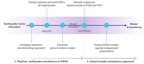
Octavi Gómez-Novell, Francesco Visini, Paula Herrero-Barbero, José A. Álvarez-Gómez, and Julián García-Mayordomo
Nat. Hazards Earth Syst. Sci., 26, 2691–2715, https://doi.org/10.5194/nhess-26-2691-2026, https://doi.org/10.5194/nhess-26-2691-2026, 2026
Short summary
Short summary
Evaluating seismic hazard requires past earthquake observations to perform accurate forecasts. Physics-based earthquake cycle simulators are algorithms that model long-term earthquake sequences on faults, overcoming completeness limitations of observations. We test the performance of physics-based seismic hazard assessments in comparison with traditional approaches in Spain. The physics-based approach yields more accurate forecasts, highlighting the potential of simulators for seismic hazard.
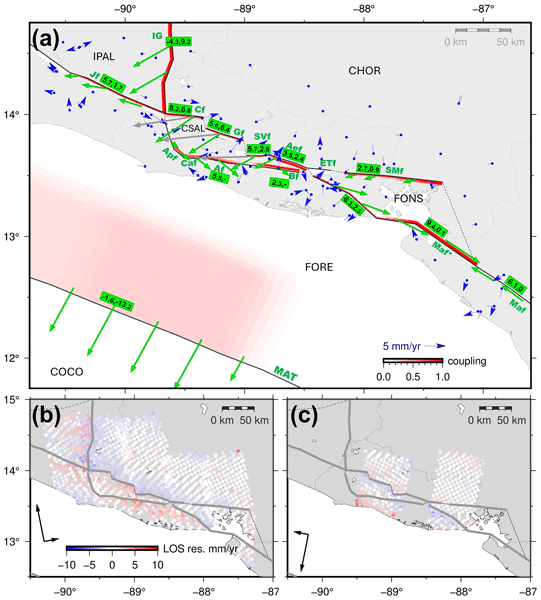
Juan Portela, Marta Béjar-Pizarro, Alejandra Staller, Cécile Lasserre, Beatriz Cosenza-Muralles, José Antonio Álvarez-Gómez, and José Jesús Martínez-Díaz
Solid Earth, 17, 369–387, https://doi.org/10.5194/se-17-369-2026, https://doi.org/10.5194/se-17-369-2026, 2026
Short summary
Short summary
We combined satellite radar and GPS data to model how the faults in El Salvador and nearby regions accumulate deformation. Motion across the central El Salvador Fault Zone is shared by several fault branches, while the offshore subduction zone appears to be weakly locked. These results improve the understanding of regional deformation and seismic hazard in Central America.
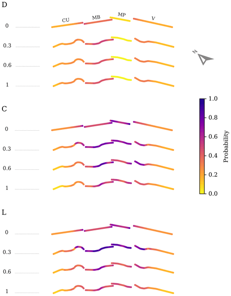
Octavi Gómez-Novell, Francesco Visini, José Antonio Álvarez-Gómez, Bruno Pace, and Julián García-Mayordomo
Nat. Hazards Earth Syst. Sci., 26, 651–673, https://doi.org/10.5194/nhess-26-651-2026, https://doi.org/10.5194/nhess-26-651-2026, 2026
Short summary
Short summary
Earthquake surface ruptures are a hazard for infrastructure and life that requires proper assessment. We use a physics-based earthquake cycle simulator to derive fault displacement hazard statistics in a test fault system and their dependence to fault geometry. Our results show that more complex fault geometries increase surface rupture probabilities and might improve the agreement with observations. Earthquake cycle simulators are thus a promising tool for fault displacement hazard analyses.
Elena Pascual-Sánchez, José Antonio Álvarez-Gómez, Julián García-Mayordomo, and Paula Herrero-Barbero
EGUsphere, https://doi.org/10.5194/egusphere-2025-4870, https://doi.org/10.5194/egusphere-2025-4870, 2025
Short summary
Short summary
This study explores whether seismic hazard depends on the time interval over which an earthquake catalogue is recorded. Using a synthetic earthquake catalogue from the Eastern Betics Shear Zone spanning 1 Myr, we divided it into 10,000 sub-catalogues, each with the same duration as the historical and instrumental catalogue – i.e., 1,000 years. The resulting hazard curves, derived from a probabilistic seismic hazard assessment, show that each sub-catalogue yields different return period values.
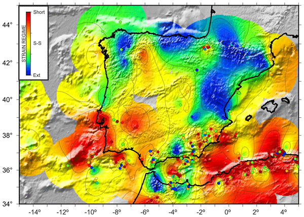
Antonio Olaiz, José A. Álvarez Gómez, Gerardo de Vicente, Alfonso Muñoz-Martín, Juan V. Cantavella, Susana Custódio, Dina Vales, and Oliver Heidbach
Solid Earth, 16, 947–1024, https://doi.org/10.5194/se-16-947-2025, https://doi.org/10.5194/se-16-947-2025, 2025
Short summary
Short summary
Understanding the stress and strain conditions in the Earth's crust is crucial for various activities, such as oil and gas exploration and assessing seismic hazards. In this article, we have updated the database of moment tensor focal mechanisms for Greater Iberia. We conducted kinematic and dynamic analyses on the selected populations, determining the average focal mechanism, strain and stress orientations, and tectonic regime. The orientation for horizontal compression is primarily N154° E.
Sergio Padilla, Íñigo Aniel-Quiroga, Rachid Omira, Mauricio González, Jihwan Kim, and Maria A. Baptista
Nat. Hazards Earth Syst. Sci., 24, 3095–3113, https://doi.org/10.5194/nhess-24-3095-2024, https://doi.org/10.5194/nhess-24-3095-2024, 2024
Short summary
Short summary
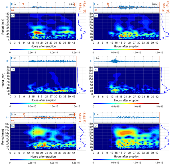
The eruption of the Hunga Tonga–Hunga Ha'apai volcano in January 2022 triggered a global phenomenon, including an atmospheric wave and a volcano-meteorological tsunami (VMT). The tsunami, reaching as far as Callao, Peru, 10 000 km away, caused significant coastal impacts. This study delves into understanding these effects, particularly on vessel mooring safety. The findings underscore the importance of enhancing early warning systems and preparing port authorities for managing such rare events.

José A. Álvarez-Gómez, Paula Herrero-Barbero, and José J. Martínez-Díaz
Nat. Hazards Earth Syst. Sci., 23, 2031–2052, https://doi.org/10.5194/nhess-23-2031-2023, https://doi.org/10.5194/nhess-23-2031-2023, 2023
Short summary
Short summary
The strike-slip Carboneras fault is one of the largest sources in the Alboran Sea, with it being one of the faster faults in the eastern Betics. The dimensions and location of the Carboneras fault imply a high seismic and tsunami threat. In this work, we present tsunami simulations from sources generated with physics-based earthquake simulators. We show that the Carboneras fault has the capacity to generate locally damaging tsunamis with inter-event times between 2000 and 6000 years.
Cited articles
Aguirre-Ayerbe, I., Martínez Sánchez, J., Aniel-Quiroga, Í., González-Riancho, P., Merino, M., Al-Yahyai, S., González, M., and Medina, R.: From tsunami risk assessment to disaster risk reduction – the case of Oman, Nat. Hazards Earth Syst. Sci., 18, 2241–2260, https://doi.org/10.5194/nhess-18-2241-2018, 2018.
Allen, S. C. R. and Greenslade, D. J. M.: Model-based tsunami warnings derived from observed impacts, Nat. Hazards Earth Syst. Sci., 10, 2631–2642, https://doi.org/10.5194/nhess-10-2631-2010, 2010.
Álvarez-Gómez, J. A.: FMC – Earthquake focal mechanisms data management, cluster and classification, SoftwareX, 9, 299–307, https://doi.org/10.1016/j.softx.2019.03.008, 2019.
Blaser, L., Kruger, F., Ohrnberger, M., and Scherbaum, F.: Scaling Relations of Earthquake Source Parameter Estimates with Special Focus on Subduction Environment, B. Seismol. Soc. Am., 100, 2914–2926, https://doi.org/10.1785/0120100111, 2010.
Catalan, P. A., Gubler, A., Cañas, J., Zuñiga, C., Zelaya, C., Pizarro, L., Valdes, C., Mena, R., Toledo, E., and Cienfuegos, R.: Design and operational implementation of the integrated tsunami forecast and warning system in Chile (SIPAT), Coast. Eng. J., 62, 373–388, https://doi.org/10.1080/21664250.2020.1727402, 2020.
CIGIDEN: A seis años del 27F: destacan las lecciones aprendidas tras la tragedia, https://www.cigiden.cl/a-seis-anos-del-27-f-destacan-las-lecciones-aprendidas-tras-la-tragedia/ (last access: 11 May 2026), 2016.
Daskalaki, E., Aguirre Ayerbe, I., Baptista, M. A., Amato, A., Cambaz, M. D., Charalampakis, M., Cugliari, L., El-Gharabawy, S. M., Hamouda, A., Hebert, H., Kalligeris, N., Cantavella Nadal, J. V., Meral Özel, N., Péroche, M., and Yalciner, A. C.: Recent Developments in Tsunami Preparedness in the Northeast Atlantic and Mediterranean Region: Challenges, Strengths, and Weaknesses , EGU General Assembly 2025, Vienna, Austria, 27 April–2 May 2025, EGU25-16032, https://doi.org/10.5194/egusphere-egu25-16032, 2025.
Dziewonski, A. M., Chou, T. -A., and Woodhouse, J. H.: Determination of earthquake source parameters from waveform data for studies of global and regional seismicity, J. Geophys. Res.-Sol. Ea., 86, 2825–2852, https://doi.org/10.1029/JB086iB04p02825, 1981.
Echave-Lezcano, J.: Elaboración de la metodología y base de datos numérica de tsunamis para el Sistema de Alerta de Tsunamis español, MS thesis, Universidad de Cantabria, Spain, 2016.
Ekström, G., Nettles, M., and Dziewoński, A. M.: The global CMT project 2004–2010: Centroid-moment tensors for 13 017 earthquakes, Phys. Earth Planet. In., 200–201, 1–9, https://doi.org/10.1016/j.pepi.2012.04.002, 2012.
Gallego Jiménez, A.: TsunamiClassifier, GitHub [code], https://github.com/AlbertGallegoJimenez/TsunamiClassifier (last access: 11 May 2026), 2025.
GEBCO Bathymetric Compilation Group 2023: The GEBCO_2023 Grid – a continuous terrain model of the global oceans and land, NERC EDS British Oceanographic Data Centre NOC [data set], https://doi.org/10.5285/f98b053b-0cbc-6c23-e053-6c86abc0af7b, 2023.
Generalitat Valenciana: La Generalitat ha activat aquest matí el Pla Territorial d'Emergències de la Comunitat Valenciana per avís del Ministeri de l'Interior de risc de tsunami, https://comunica.gva.es/va/detalle?id=359855854&site=174860102 (last access: 11 May 2026), 2015.
Harig, S., Immerz, A., Weniza, Griffin, J., Weber, B., Babeyko, A., Rakowsky, N., Hartanto, D., Nurokhim, A., Handayani, T., and Weber, R.: The Tsunami Scenario Database of the Indonesia Tsunami Early Warning System (InaTEWS): Evolution of the Coverage and the Involved Modeling Approaches, Pure Appl. Geophys., 177, 1379–1401, https://doi.org/10.1007/s00024-019-02305-1, 2020.
Igarashi, Y., Ueno, T., Nakata, K., Hernandez-Grennan, V. C., Cruz-Salcedo, J. L., Narag, I. C., Bautista, B. C., and Koizumi, T.: Building a Tsunami Simulation Database for the Tsunami Warning System in the Philippines, Journal of Disaster Research, 10, 51–58, https://doi.org/10.20965/jdr.2015.p0051, 2015.
Indian National Centre for Ocean Information Services (INCOIS): Standard Operating Procedure for the Indian Tsunami Early Warning Centre (ITEWC), INCOIS, Hyderabad, India, https://incois.gov.in (last access: 11 May 2026), 2011.
Instituto Geográfico Nacional (IGN) and Dirección General de Protección Civil y Emergencias: Plan Estatal de Protección Civil ante el riesgo de maremotos. Edición comentada, Centro Nacional de Información Geográfica and Ministerio del Interior – Centro de Publicaciones, Madrid, Spain, https://doi.org/10.7419/162.02.2022, 2021.
Intergovernmental Oceanographic Commission (IOC): Tsunami Glossary, 2013, Revised Edition 2013, IOC Technical Series, 85, UNESCO, Paris (IOC/2008/TS/85rev), 2013.
Japan Meteorological Agency: Tsunami Warnings/Advisories, https://www.data.jma.go.jp/eqev/data/en/guide/tsunamiinfo.html (last access: 11 May 2026), 2025.
Kanamori, H.: The energy release in great earthquakes, J. Geophys. Res., 82, 2981–2987, https://doi.org/10.1029/JB082i020p02981, 1977.
Løvholt, F., Kaiser, G., Glimsdal, S., Scheele, L., Harbitz, C. B., and Pedersen, G.: Modeling propagation and inundation of the 11 March 2011 Tohoku tsunami, Nat. Hazards Earth Syst. Sci., 12, 1017–1028, https://doi.org/10.5194/nhess-12-1017-2012, 2012.
Macías, J., Castro, M. J., Ortega, S., Escalante, C., and González-Vida, J. M.: Performance Benchmarking of Tsunami-HySEA Model for NTHMP's Inundation Mapping Activities, Pure Appl. Geophys., 174, 3147–3183, https://doi.org/10.1007/s00024-017-1583-1, 2017.
Macías, J., Castro, M. J., Ortega, S., and González-Vida, J. M.: Performance assessment of Tsunami-HySEA model for NTHMP tsunami currents benchmarking. Field cases, Ocean Model., 152, 101645, https://doi.org/10.1016/j.ocemod.2020.101645, 2020.
Macías-Sánchez, J., Castro-Díaz, M. J., González-Vida, J. M., De la Asunción, M., and Ortega, S.: HySEA: An operational GPU-based model for Tsunami Early Warning Systems, in: Geophysical Research Abstracts, EGU General Assembly 2014, Vienna, Austria, 27 April–2 May 2014, EGU2014-14217, http://hdl.handle.net/10630/7489 (last access: 11 May 2026), 2014.
MarCom Working Group 122: Tsunami disasters in ports due to the Great East Japan Earthquake, PIANC report, Brussels, 1–138 pp., ISBN 978-2-87223-211-6, 2014.
National Geophysical Data Center/World Data Service: NCEI/WDS Global Historical Tsunami Database, NOAA National Centers for Environmental Information, https://doi.org/10.7289/V5PN93H7, 2024.
National Oceanic and Atmospheric Administration (NOAA) and National Weather Service (NWS): User's Guide for the Tsunami Warning System in the U.S. National Tsunami Warning Center Area-of-Responsibility, NOAA/NWS/NTWC, Palmer, Alaska, USA, Version 6.7, http://tsunami.gov (last access: 11 May 2026), 2017.
Necmioğlu, Ö., Turhan, F., Özer Sözdinler, C., Yılmazer, M., Güneş, Y., Cambaz, M. D., Altuncu Poyraz, S., Ergün, T., Kalafat, D., and Özener, H.: KOERI's Tsunami Warning System in the Eastern Mediterranean and Its Connected Seas: A Decade of Achievements and Challenges, Appl. Sci., 11, 11247, https://doi.org/10.3390/app112311247, 2021.
Okada, Y.: Surface deformation due to shear and tensile faults in a half-space, B. Seismol. Soc. Am., 75, 1135–1154, https://doi.org/10.1785/BSSA0750041135, 1985.
Papadopoulos, G. and Imamura, F.: A proposal for a new tsunami intensity scale. International Tsunami Symposium 2001 Proceedings, Seattle, Washington, USA, 7–10 August 2001, 569–577, 2001.
Reuters: Tribunal chileno acoge salida extrajudicial para imputados en fallida alerta de tsunami, Reuters, https://www.reuters.com/article/world/americas/tribunal-chileno-acoge-salida-extrajudicial-para-imputados-en-fallida-alerta-de-idUSKCN0X42BV/ (last access: 11 May 2026), 2016.
Röbke, B. R. and Vött, A.: The tsunami phenomenon, Prog. Oceanogr., 159, 296–322, https://doi.org/10.1016/j.pocean.2017.09.003, 2017.
Roudil, P., Schindelé, F., Bossu, R., Alabrune, N., Arnoul, P., Duperray, P., Gailler, A., Guilbert, J., Hébert, H., and Loevenbruck, A.: The French tsunami warning center for the Mediterranean and Northeast Atlantic: CENALT, Science of Tsunami Hazards, 32, 1–7, Tsunami Society International, 2013.
Satake, K.: Advances in earthquake and tsunami sciences and disaster risk reduction since the 2004 Indian ocean tsunami, Geosci. Lett., 1, 15, https://doi.org/10.1186/s40562-014-0015-7, 2014.
Selva, J., Lorito, S., Volpe, M., Romano, F., Tonini, R., Perfetti, P., Bernardi, F., Taroni, M., Scala, A., Babeyko, A., Løvholt, F., Gibbons, S. J., Macías, J., Castro, M. J., González-Vida, J. M., Sánchez-Linares, C., Bayraktar, H. B., Basili, R., Maesano, F. E., Tiberti, M. M., Mele, F., Piatanesi, A., and Amato, A.: Probabilistic tsunami forecasting for early warning, Nat. Commun., 12, 5677, https://doi.org/10.1038/s41467-021-25815-w, 2021.
Servicio Hidrográfico y Oceanográfico de la Armada de Chile (SHOA): Guía de Referencia Sistema Nacional de Alarma de Maremotos, 3rd edn., SHOA, Valparaíso, Chile, https://www.shoa.cl/ (last access: 11 May 2026), 2023 (updated 2025).
Soulé, B.: Post-crisis analysis of an ineffective tsunami alert: the 2010 earthquake in Maule, Chile, Disasters, 38, 375–397, https://doi.org/10.1111/disa.12045, 2014.
Synolakis, C. E. and Bernard, E. N.: Tsunami science before and beyond Boxing Day 2004, Philos. T. Roy. Soc. A, 364, 2231–2265, https://doi.org/10.1098/rsta.2006.1824, 2006.
Tinti, S., Graziani, L., Brizuela, B., Maramai, A., and Gallazzi, S.: Applicability of the Decision Matrix of North Eastern Atlantic, Mediterranean and connected seas Tsunami Warning System to the Italian tsunamis, Nat. Hazards Earth Syst. Sci., 12, 843–857, https://doi.org/10.5194/nhess-12-843-2012, 2012.
Tsunami Inundation Database Portal: https://www.risksciences.ucla.edu/nhr3/tsunami-portal, last access: 7 August 2024.
U.S. Geological Survey: Earthquake Hazards Program, 2017, Advanced National Seismic System (ANSS) Comprehensive Catalog of Earthquake Events and Products: Various, https://earthquake.usgs.gov/earthquakes/search/ (last access: 11 May 2026), 2017.
Wang, X. and Liu, P. L.-F.: Numerical simulations of the 2004 Indian Ocean tsunamis-coastal effects, J. Earthq. Tsunami, 1, 273–297, https://doi.org/10.1142/S179343110700016X, 2007.
Editorial statement
This study introduces the simulation-based global dataset, TSUSY, that systematically links earthquake characteristics to tsunami occurrence, providing an unprecedented foundation for understanding the global-scale tsunamigenic potential. It further advances the field by developing a robust, operationally relevant tsunami-occurrence criterion that enhances real-time decision-making and balances missed events and false alarms in tsunami warning systems.
This study introduces the simulation-based global dataset, TSUSY, that systematically links...
Short summary
Tsunamis can have devastating consequences, yet it remains challenging to identify which earthquakes generate them. This study presents a criterion for identifying tsunamigenic events based on numerical simulations, as well as a global database of tsunami simulations based on historical earthquakes. By comparing the results with historical records, this approach can improve tsunami identification and support tsunami warnings worldwide.
Tsunamis can have devastating consequences, yet it remains challenging to identify which...


Altmetrics
Final-revised paper
Preprint