the Creative Commons Attribution 4.0 License.
the Creative Commons Attribution 4.0 License.
 | 19 May 2026
Detection of atmospheric rivers affecting the western Mediterranean and producing extreme rainfall over northern-central Italy
Isacco Sala
Alessandro Comunian
Daniele Mastrangelo
Mario Marcello Miglietta
Lucia Drago Pitura
Federico Grazzini
Atmospheric rivers (ARs) have been recently identified in the Mediterranean basin, where they have been shown to play an important role in intense precipitation events over northern Italy and the Alpine chain. In fact, as demonstrated by two recent severe events (27–29 October 2018; 2–3 October 2020), the synoptic pattern conducive to heavy rainfall in this area may favour intense moisture transport from remote regions towards the Alps. In these events there was either a south-westerly moisture advection directly from the Atlantic Ocean Tropical area across the African continent, or a north-westerly transport over the Atlantic area, entering the Mediterranean in correspondence of the Gibraltar Strait.
In order to identify ARs in such a complex geographical area, a well-known algorithm of objective detection has been adapted to the morphology of the Mediterranean basin and to the peculiar shape of the organized water vapour transport, which may differ from that generally observed in the ARs over the open ocean. The two above-mentioned case studies have been used for testing the procedure.
The algorithm has been applied in conjunction with some additional selection criteria to identify only those AR events in the western Mediterranean that affected northern-central Italy over the last ∼ 60 years. A climatological analysis is provided and the possible correspondence between the most intense identified ARs and extreme rainfall events is investigated. Exploiting a precipitation dataset for northern-central Italy (ArCIS), some areas turned out to be particularly exposed to extreme precipitation events in the presence of ARs.
- Article
(7657 KB) - Full-text XML
- BibTeX
- EndNote


In the last decades, there has been growing interest in studying the transport of relevant amounts of atmospheric moisture from the (sub-) Tropics to the midlatitudes. This transport may sometimes be organized in the lower troposphere, assuming the form of narrow corridors named atmospheric rivers (ARs; Ralph et al., 2018). ARs play a key role in modulating the global water cycle, being responsible for most of the water vapour transport at midlatitudes. Most importantly, ARs are strongly associated with heavy precipitation and floods in many regions around the world (Gimeno et al., 2014, for a short review). Since the pioneering study of Zhu and Newell (1998), ARs have been investigated especially over the eastern Pacific Ocean and the US West Coast (Neiman et al., 2011; Ralph et al., 2006; Rutz et al., 2014, among others). There, several field campaigns over the past two decades took place (CALJET – California Land-falling Jets Experiment, Ralph et al., 2004; PACJET – Pacific Landfalling Jets Experiment, Ralph et al., 2005; HMT – Hydrometeorology Testbed, Ralph et al., 2013) and a reconnaissance program has been activated (Lavers et al., 2024; Zheng et al., 2024), allowing to gain a deeper understanding of AR dynamics and characteristics, as well as to improve the forecasting of their impacts at different time scales.
In the last years, the impact of ARs has become evident in other parts of the globe (Gimeno et al., 2016; Vallejo-Bernal et al., 2025) and the interest in the topic has increased also over Europe. The link between ARs and extreme precipitation in Europe was first pointed out by Stohl et al. (2008) whose study, focussed on Norway, was followed by several papers dealing with other regions of western Europe: among others, Lavers et al. (2011) for the British Isles, Ramos et al. (2015) for the Iberian Peninsula, Benedict et al. (2019) for the Scandinavian Peninsula, and Doiteau et al. (2021) for France. All these authors showed that AR landfall on the western European Atlantic coast produces extreme precipitation when an anomalous amount of moisture, coming mainly from subtropical or tropical areas but also from mid-latitude regions, impinges in the form of an AR on the coastal orography and is forced to rise and condense. Lavers and Villarini (2013), Rössler et al. (2014), and Ionita et al. (2020) analysed the AR effects also over central Europe, revealing that the coastal orography of western Europe, relatively lower compared to that of the US West coast, allows a deeper inland penetration.
Only a few studies have so far investigated the presence of ARs across the Mediterranean basin and their possible role in modulating heavy rainfall over southern Europe and Italy in particular, although the importance of the large-scale moisture transport from regions outside the Mediterranean is known to be often associated with torrential precipitation (Insua-Costa et al., 2022). Some studies suggested a link between long-range transport of humidity and extreme precipitation (Malguzzi et al., 2006; Buzzi et al., 2014), but Krichak et al. (2015) were the first that applied a specific diagnostic, simply based on Integrated Vapour Transport (IVT) maps, to detect an AR during the infamous 1966 “century” flood in Florence (Italy). More recently, Davolio et al. (2020) objectively detected the presence of an AR and investigated in detail its role, through an atmospheric water budget computation, during “Vaia” (Cavaleri et al., 2019; Giovannini et al., 2021), a major Mediterranean storm that caused extensive damages over the Alps. Lorente-Plazas et al. (2019) demonstrated the existence and importance of moisture transport through AR-like structures in the western Mediterranean and their hydrometeorological impact over the southern Spanish coast. Finally, ARs have been documented in some recent heavy precipitation events in the Mediterranean (Martinković et al., 2017; Davolio et al., 2023; Ezber et al., 2024; Francis et al., 2024) and in association with severe dust storms moving from the Sahara Desert towards Europe (Francis et al., 2022).
The Mediterranean basin is characterized by a complex morphology. Together with the presence of complex orography, often close to the coastal areas, this aspect may pose some complications in the application of detection methodologies generally suitable for open ocean areas. Moreover, two recent heavy precipitation episodes over Italy, that will be used as a testbed in the present work, have shown that the origin of moisture can be either the tropical Africa or the North Atlantic. The different origin is associated with a very different geometry and shape of the ARs, sometimes jeopardizing automatic detection algorithms looking for objects typically oriented from southwest to northeast. Therefore, Mediterranean complexity requires a particular care, as also stressed by Lorente-Plazas et al. (2019). It should be noted that alternative methodologies have recently led to the development of more sophisticated algorithms (e.g., PIKART, Vallejo-Bernal et al., 2025) to address challenges in complex regions.
The aim of the present study is to exploit a well-known AR detection algorithm (Guan and Waliser, 2015, GW15 hereinafter), largely used in the scientific literature, adapted to the complexity of the Mediterranean basin (as described in Sect. 3), testing the results on two case studies previously analysed in recent research activities, and set up a methodology (Sect. 4) that allows to identify ARs in the western Mediterranean, affecting the target area of northern-central Italy. Finally, statistics and results concerning the connection between ARs and extreme rainfall events are provided in Sect. 5.
The ERA5 reanalysis dataset (Hersbach et al., 2020) is used in this study for both the synoptic analysis of the events and the AR detection procedure presented in the following section. For the latter, the longitudinal and meridional component of IVT, named IVTu and IVTv in the following, have been extracted at 0.25° resolution every 6 h over the area 20–60° N, 30° W–30° E, for the period between 1961 and 2024.
This 64 year period, as well as the target area of northern-central Italy, have been selected considering the availability of a high-resolution (5 km × 5 km) gridded daily precipitation dataset named ArCIS. As described in Pavan et al. (2019), ArCIS is derived from the interpolation of a high-density surface observation network, consisting of more than 1700 raingauges distributed on 11 Italian regions, and includes also several stations of adjacent Alpine regions. Following a previous elaboration of the dataset (Grazzini et al., 2020), the daily precipitation is aggregated over 94 area units of the Italian Department of Civil Protection, defined for the national operational warning system. These areas aggregate homogeneous subregional hydrological basins of the territory (see Fig. 1 in Grazzini et al., 2020). The ArCIS dataset is exploited here to characterize the most intense events reported in the following sub-sections and in Sect. 5, and to investigate the possible correspondence between ARs and extreme precipitation events. The condition of extreme precipitation is attained when the aggregated observed daily precipitation of one or more of the 94 warning areas exceeds the 99th percentile of its wet-days climatology (with respect to the recent climate period, 1991–2020). This approach follows that of Grazzini et al. (2024); the choice of the rainfall aggregation and of the recent 30 year period is aimed at reaching results almost applicable to operations, since it allows to recognise EPE with respect to recent climatic conditions on operational areas.
Two recent heavy precipitation episodes affecting northern and central Italy have been selected as testbeds since they were related to ARs with very different characteristics. They are briefly described in the following, but in-depth descriptions may be found in the references provided hereafter.
2.1 27–29 October 2018: storm “Vaia”
Between 27 and 29 October 2018, heavy rainfall, floods, storm surges and an extreme windstorm, associated with an explosive Mediterranean cyclogenesis, affected many parts of the Italian Peninsula, especially the north-eastern Alpine regions. Several recent papers (Cavaleri et al., 2019, Davolio et al., 2020, Giovannini et al., 2021) investigated the effects of this storm (also known as “Adrian”), comparable to the “century” flood of November 1966 (Malguzzi et al., 2006; Sioni et al., 2023) in terms of precipitation volume over northern-central Italy (Grazzini et al., 2020). A large amplitude baroclinic wave developed over the North Atlantic and western Europe, favouring intense meridional heat and moisture exchanges. An upper-level trough deepened over the Iberian Peninsula and extended over North Africa as it slowly evolved eastward (Fig. 5a–c in Davolio et al., 2020). Within this large-scale setting, typical of heavy rainfall over the Alps in autumn (Grazzini et al., 2021), cyclogenesis occurred over the western Mediterranean on 29 October, and a very intense surface low moved across the basin (Fig. 5d–f in Davolio et al., 2020), further intensifying the moisture transport coming from remote tropical areas, as shown in Fig. 1a. The AR, together with an initial moisture input also from the Atlantic, contributed critically to heavy rainfall (Davolio et al., 2020; Sioni et al., 2023), reaching a local peak of almost 900 mm in 72 h in the eastern Alps (Fig. 1c).
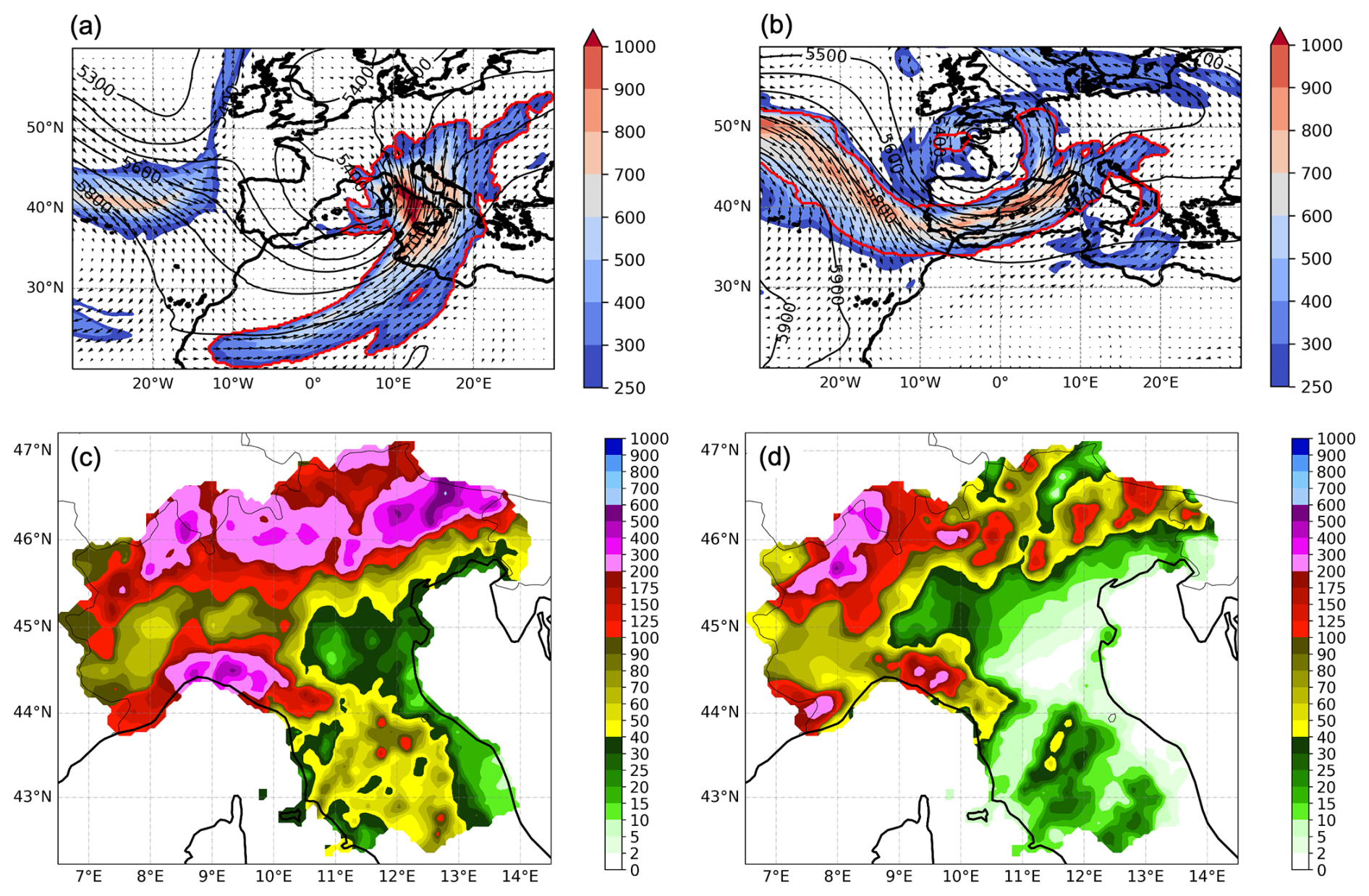
Figure 1500 hPa geopotential height (m, black contour lines) and IVT (, colour shading and vectors) for (a) the Vaia storm, at 12:00 UTC, 29 October 2018 and for (b) Alex storm, at 12:00 UTC, 2 October 2020. The red bold line surrounds the object identified as an AR. Total precipitation (mm) accumulated in the two events: (c) in 72 h between 27 and 29 October 2018 and (d) in 24 h on 2 October 2020. Precipitation data are extracted from the ArCIS dataset (Pavan et al., 2019).
2.2 2–3 October 2020: storm “Alex”
Within a North Atlantic large-scale upper-level trough, a rapid cut-off process occurred at the beginning of October 2020 between UK and France (Fig. 2 in Davolio et al., 2023). The extra-tropical cyclone, named “Alex” by MeteoFrance on behalf of EUMETNET, but also known as “Brigitte”, intensified very rapidly due to the upper level forcing of a very intense jet stream, and moved south-eastward, hitting the Britain coast on 2 October, where wind gusts exceeding 50 m s−1 were recorded (Magnusson et al., 2021). During 2 October, the cyclone, whose minimum mean sea level pressure reached 970 hPa, remained almost stationary over north-western France, while the associated cold front progressively swept over the Mediterranean basin causing floods over Spain, France, and Italy. As shown in Fig. 1b, ahead of the cold front, an intense water vapor transport occurred, in the form of an impressive AR elongated from the North Atlantic, entering the Mediterranean basin through the Gibraltar Strait. The huge amount of moisture was responsible for heavy rainfall in Italy (Fig. 1d), over both the north-western coastal regions and the Alps (Davolio et al., 2023). Precipitation in excess of 300 mm affected a wide area of Liguria and Piedmont regions (for locations refer to Fig. 2), with local peaks above 500 mm in 12 h. 2 October was classified as the rainiest day in Piedmont (in terms of average rainfall amount over the region) in the last 60 years with catastrophic consequences on the environment and infrastructure (Acordon and Cat Berro, 2024).
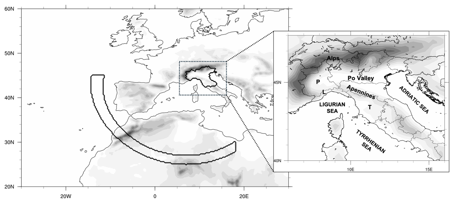
Figure 2Domain considered for the identification of Mediterranean ARs. Shading represents orography elevation every 250 m. The administrative area of northern-central Italy is surrounded by a bold line, and it represents the target area where precipitation observations (ArCIS) are available. The arc-shaped area, together with the target area, must be covered at the same time by the shape of the AR, in order to select the AR for our analysis. Locations cited in the text are indicated on the zoomed map. L, P and T indicate Liguria, Piedmont and Tuscany region, respectively.
Since the number of studies dealing with ARs has increased, many detection methods have been developed, differing in the selected variables, applied criteria, and input data (Shields et al., 2018). The first detection procedures were based on the total column IWV since this variable was easily available from polar satellite microwave retrievals. A feature characterized by IWV > 2 cm, length > 2000 km, and width < 1000 km was defined as an AR by Ralph et al. (2004), who were the first to impose conditions for setting the boundaries of ARs, based on the CALJET field campaign results.
However, it became soon evident that the use of IVT, instead of IWV, permits a much more robust identification of a phenomenon that is characterized by both moisture and wind. Therefore, exploiting the availability of several global reanalysis datasets, most of the methodologies have been based on IVT, setting different thresholds (either fixed or climatologically based), together with geometric (shape) and temporal (persistence) criteria, possibly filtering out features that resemble ARs but are not. An IVT threshold of 250 has been typically adopted for midlatitudes (Rutz et al., 2014), although it may not be always appropriate (Reid et al., 2020), sometimes in combination with an IWV threshold (e.g., 15 mm in Gershunov et al., 2017). However, other studies applied variable IVT thresholds based on the percentiles of IVT (e.g., Lavers et al. (2012) adopted percentiles between 84th and 86th computed for the 1998–2005 period), suitable to diagnose an anomalous moisture transport in a specific area and season. The Atmospheric River Tracking Method Intercomparison Project (ARTMIP; Shields et al., 2018; Rutz et al., 2019) is an international effort aimed at quantifying uncertainties associated with different detection algorithms, possibly highlighting strengths and weaknesses. Interestingly, the choice of the reanalysis dataset turned out to impact the results less than the detection method adopted (Ralph et al., 2019).
At the time this study was initiated, GW15 represented one of the most widely used algorithm, combining intensity and geometry thresholds for AR identification: (i) a percentile-based threshold for IVT, depending on season and location, in combination with a fixed threshold (100 ) that gets rid of climatologically weak-IVT areas; (ii) shape requirements, i.e. AR length > 2000 km, and aspect ratio (length/width) > 2. Contiguous areas that satisfy these criteria identify objects candidate to be ARs, which then undergo other additional directional requirements, such as the direction of the object-mean IVT (poleward component IVTv > 50 ). To apply the algorithm, the 85th percentile IVT was previously computed for each month of the year (considering the 5 month centred on that month), based on daily values at 12:00 UTC for the 30 year period ranging from 1991 to 2020.
The application of the algorithm to the two case studies described in the previous section highlighted some issues that have been addressed through minor modifications of the original code. In more detail, the main failures of the GW15 algorithm concerned the detection of the AR during the October 2020 event, due to its complex U-shaped structure (Fig. 1b), since GW15 is designed for poleward moisture transport only (IVTv > 0) and requires a strict “coherence” in IVT direction with respect to the object's mean IVT. Also, the 2018 event highlighted the necessity to filter out IVT features related to the cyclonic circulation. Therefore, in order to identify an AR object appropriate to represent the intense transport of humidity over the Mediterranean in both case studies, we finally allowed a southward transport, and we also retained westward IVT, provided that the poleward component remained predominant. Moreover, after many trials and errors, the coherence was increased to 65° (instead of 45°). Notably, a recent update of the detection algorithm (Guan and Waliser, 2024, their Fig. 3 in particular) adopted similar refinements to allow the detection of zonal or even equatorward ARs, and to eliminate features associated with cyclones, thus supporting the validity of our modifications.
Finally, some preliminary sensitivity tests showed that the fixed IVT minimum threshold of 100 was not appropriate for the Mediterranean area. In fact, increasing this value to 250 , which is a widely adopted threshold since Rutz et al. (2014), allowed to better identify AR-like structures in the area, emerging from the IVT background which is on average relatively high in the Mediterranean.
Once verified that the approach correctly identified the ARs for the two selected case studies for all the 6-hourly time steps (along with other selected events – not shown), it was subsequently applied to the full dataset, as described in the following Section.
The application of the algorithm to the 6-hourly ERA5 dataset over the target area (20–60° N, 30° W–30° E) for the period ranging from 1961 to 2024, identifies almost one thousand AR objects that satisfy the conditions defined in the previous Section. The aim of the present study is to identify only the AR objects over the western Mediterranean that affect the target area of northern-central Italy and group together those related to the same event. The selection procedure is described in the present Section.
Precipitation events over northern-central Italy are often characterized by warm and moist air advection over the Tyrrhenian and Adriatic Seas, taking the form of southerly low-level jets during severe events (Buzzi and Foschini, 2000; Miglietta and Davolio, 2022) conveying water vapour towards the Apennines and the Alpine slopes. It is not rare that elongated corridors of moisture transport appear in the Mediterranean, although too short to be considered ARs. Sometimes, the identification of the axis of these objects produces an overestimation of their length, since the algorithm may detect a zigzag axis instead of an almost continuous line. Thus, it may happen that “false” ARs are detected. In order to distinguish between this intense but local transport from the Mediterranean basin and the vapour really coming from remote sources, and to select only ARs making landfall on the target area, an additional condition is required: the shape of the AR object identified by the detection algorithm must cover at the same time both the target area over northern-central Italy and a remote source region outside the Mediterranean (Fig. 2). The latter is devised to intercept ARs reaching the Mediterranean from either Africa tropical areas or the North Atlantic, as in the two selected case studies, and imposes a length of at least 2000 km.
Also, a temporal requirement is imposed in the AR detection, that is the AR must cover the target area and the remote source regions in Fig. 2a for at least three 6-hourly time steps. It means that only AR objects persisting for 12 h or more are considered as AR events. Although these requirements on length and duration are somehow arbitrary and conservative, a similar approach was followed also in previous studies (Lavers and Villarini, 2013; Ramos et al., 2015; Gershunov et al., 2017; Lorente-Plazas et al., 2019).
The whole procedure provides the AR shape and axis in a netcdf file. Moreover, in a text file, the time/data of start and end of each event is provided. Unfortunately, since the Mediterranean is an enclosed basin, entirely surrounded by land areas and characterized by several islands, the algorithm cannot provide the exact position of the landfall over the Italian peninsula, which would assume only one sea–land transition along the AR path. In order to provide an estimate of the intensity of the AR, the maximum IVT magnitude during the event, attained within the object shape over the sea in proximity of the Italian coast (between 40–44.5° N and east of 7° E), is selected and reported in the same file.
Finally, a careful check of all the selected events was performed to manually exclude few events in which the detection was due to AR objects clearly flowing to the north of the Alps, but with some marginal or residual object portion slightly overlapping the target area. Following this procedure, a dataset of ARs affecting northern Italy is now available (Davolio, 2026).
A total of 357 AR events affecting northern-central Italy are identified between 1961 and 2024, with an average of 5.6 AR events per year (Fig. 3). Two events are considered independent if separated at least by one day. During 1987, a maximum of 13 events was attained, whilst in 1989, 2005 and 2007 only one event occurred. The slight increase in the number of AR (0.3 events per decade) is not statistically significant.
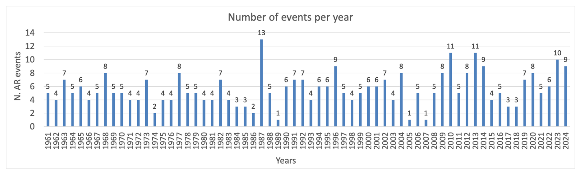
Figure 3Number of AR events affecting northern-central Italy each year, in the period 1961–2024.
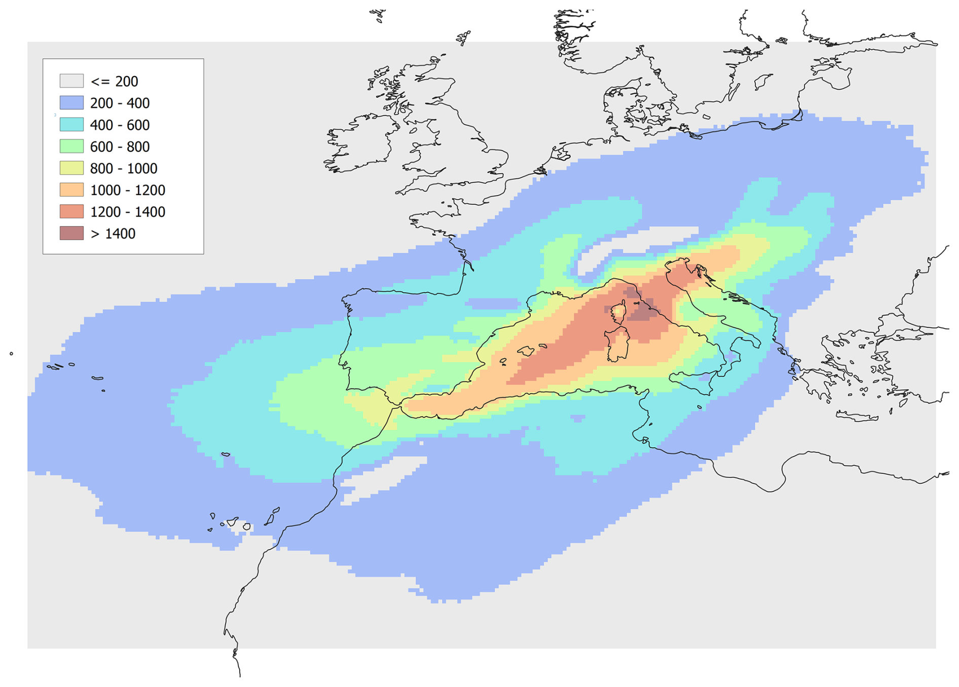
Figure 4Number of 6-hourly time steps during which a grid point is within the shape of an AR, within the period 1961–2024.
To better appreciate the frequency climatology for ARs entering the western Mediterranean and reaching northern–central Italy, Fig. 4 shows the number of 6-hourly time steps during which a grid point is within the shape of an AR. Given the relatively small extent of the target area of norther-central Italy, there is a clear convergence of the detected ARs towards it. However, this spatial distribution clearly highlights two main AR pathways, one from the Atlantic oriented from southwest to northeast, and the other, directed meridionally, from North Africa. The low values over the Alps are due to the underlying orography that compromise the IVT computation.
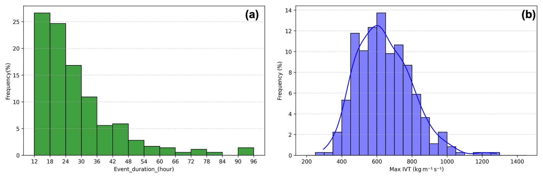
Figure 5Frequency distribution of (a) duration of AR events and (b) AR intensity, defined as max IVT attained close to the Italian peninsula coastline.
In terms of intensity and duration, Fig. 5a shows that about half of the events end within 24 h, and almost 90 % within 48 h. It is worth recalling that, following the criteria defined in Sect. 4, the lifetime includes only the period during which the shape of the AR, as provided by the detection algorithm, overlaps both the target area of northern-central Italy and the curved area outside the Mediterranean. Therefore, it might be possible that the AR persists longer over the Mediterranean basin besides this period. The maximum IVT distribution is centred around 600 , with some remarkable events that exceed 1000 (Fig. 5b).
The monthly distribution of AR events as a function of their intensity is provided in Fig. 6, where the AR classification is based on maximum IVT, which is considered suitable for assessing the AR strength (Ralph et al., 2017): weak (between 250 and 500 ), moderate (500–750 ), strong (750–1000 ), extreme (1000–1250 ), and exceptional for larger values.
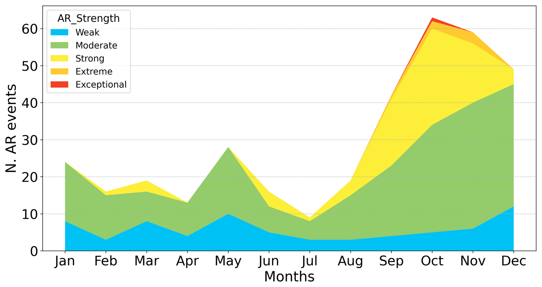
Figure 6Monthly distribution of the number of ARs for the entire period 1961–2024, following a classification based on max IVT.
Figure 6 shows clearly that autumn-early winter is the period of the year most favourable to AR in the area, while a secondary much weaker peak appears in spring. Also, autumn is the only season that experiences the presence of very intense ARs belonging to the two highest categories. This result agrees with the findings of Grazzini et al. (2020) who studied extreme precipitation over the same target area. They found that, during extreme precipitation events, the intensity of the meridional component of IVT (computed over a domain similar to the small zoomed area in Fig. 2) presents a behaviour similar to the AR frequency shown in Fig. 6, with a clear maximum in autumn due to both enhanced moisture availability and a favourable phasing of the upper-level circulation. This is an indication that ARs, and not only local moisture transport, can be strictly connected to extreme rainfall in northern-central Italy.
Table 1The 7 most intense ARs over the Mediterranean, affecting northern Italy between 1961–2024.
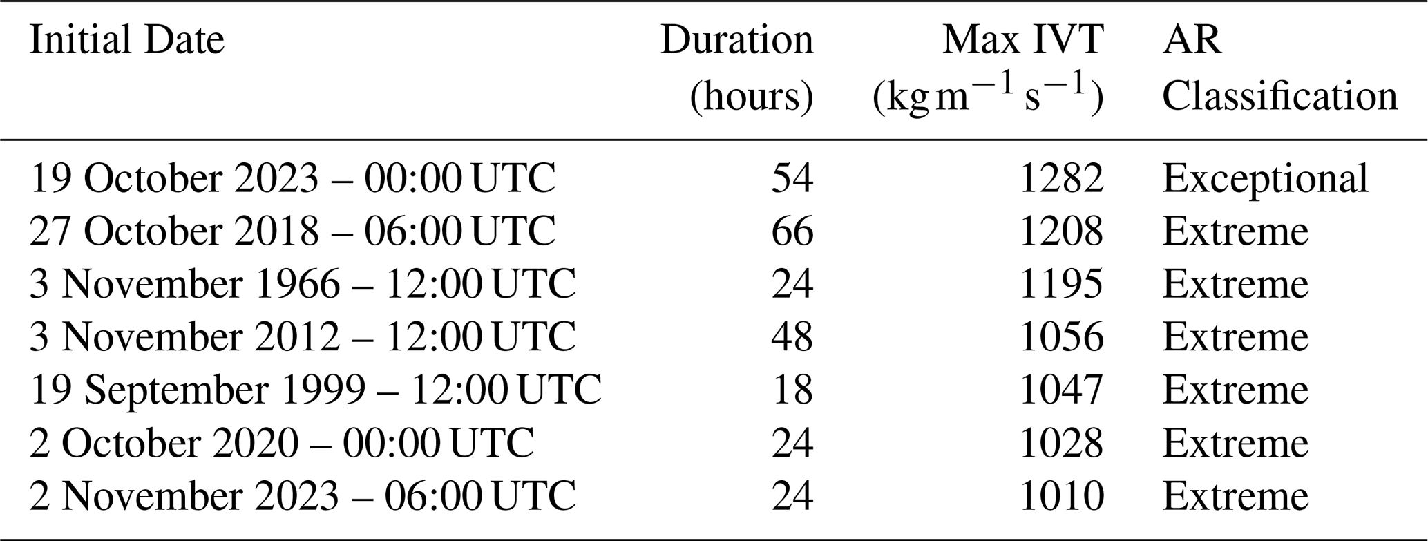
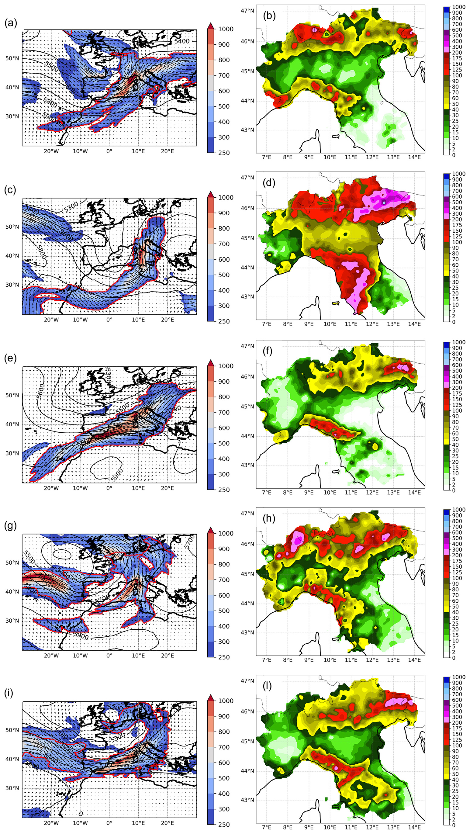
Figure 7The most intense AR events in terms of max IVT in the catalogue, as reported in Table 1. Left column: IVT (, shading and vectors), geopotential height at 500 hPa (m) and the AR object identified by the bold red line; right column: accumulated precipitation (mm in 48 h) for each event. Note that two intense events were already shown in Fig. 1. (a, b) 20 October 2023, 06:00 UTC, (c, d) 4 November 1966, 00:00 UTC, (e, f) 5 November 2012, 00:00 UTC, (g, h) 20 September 1999, 00:00 UTC and (i, l) 2 November 2023, 18:00 UTC.
A preliminary analysis ranked the identified AR events based on the associated maximum IVT magnitude (Table 1 and Fig. 7). Interestingly, both the selected events discussed in Sect. 2 are included in this ranking (2018 Vaia storm as second and 2020 Alex storm as sixth), as well as the well-known century flood of 1966 (Malguzzi et al., 2006; Sioni et al., 2023) that severely affected Tuscany region (particularly the city of Florence) and the north-eastern Italian Alps, including the city of Venice (De Zolt et al., 2006).
The most intense AR event in the list affected mainly southeastern France and the western Alps and only briefly and marginally the Italian peninsula during its strongest phase. In fact, being strongly west-east oriented, most of the precipitation occurred over the Alpine divide, but especially on the French side (MeteoFrance, 2023). In any case, extreme precipitation and floods were reported also over Italy (ARPA Piemonte, 2023).
The 2012 event was monitored during the Special Observing Period of the HYMEX field campaign (Ducrocq et al., 2014). The AR, driven by a smooth trough over the western Mediterranean, induced heavy rainfall mainly over Liguria and Tuscany (Intensive Observation Period 19, see Ferretti et al., 2014, for further details), with convection over the Ligurian Sea and orographic precipitation along the Maritime Alps.
For the 1999 event, short and intense precipitation was reported (Provincia Autonoma TN, 1999) together with minor floods and bank erosion in the central Alpine area.
Finally, the November 2023 event was characterized by major floods in Tuscany (LaMMA, 2023) with extreme precipitation (return time estimated around 50 years) that affected also the Apennine divide producing local floods, soil erosion and landslides in the northern side of the mountain chain (ARPAE, 2023).
The most intense ARs are associated with heavy precipitation events and severe impacts on the affected areas, thus indicating that extreme transport of humidity from remote areas leads to extreme rainfall and can represent an important diagnostic to take into account for forecasting purposes.
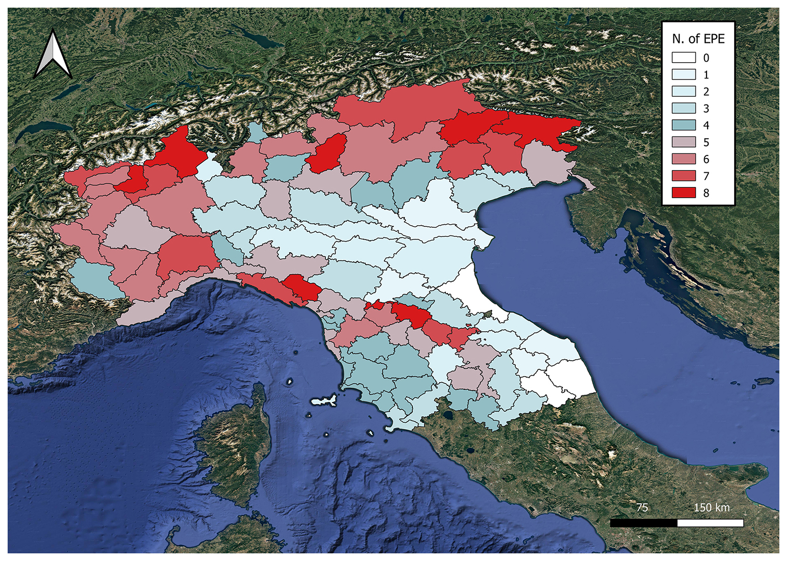
Figure 8Number of the ten most intense extreme precipitation events, for each warning area, that are associated with the presence of an AR. Red shading indicates a percentage greater or equal than 50 % (figure made with QGIS).
To further investigate the nexus between extreme precipitation and ARs, following the methodology proposed by Lavers and Villarini (2013) for Europe, the top ten extreme precipitation events have been extracted for each warning area. Figure 8 shows the number of these events associated with an AR. Over most of the Alpine area, more than half of extreme events are caused by an AR. Some regions in the north-western and in the north-eastern Alpine sectors present 8 out of 10 events connected with ARs. Similarly, the mountain chain of Liguria region, close to the coastal line, and the region close to the northern Apennine crest reaching elevation up to about 2000 m, are strongly affected by the impact of ARs. Conversely, the Po Valley, which lays in the lee of the Apennines with respect to the prevailing westerly or south-westerly currents, the northern slopes of the Apennines themselves, as well as the Adriatic areas, appear to be shielded by the orographic effect and ARs are clearly not the main cause of extreme events. Moving south over central Italy, where the orography does not attain very high elevations and ARs are not frequently perpendicular to the mountain axis, ARs present some impact, although they do not dominate the upper tail of the rainfall distribution.
The present study aimed to identify ARs entering the western Mediterranean and to select those affecting the target area of northern-central Italy. Based on a well-known AR detection algorithm, the methodology, applied to ERA5 reanalysis for the period 1961–2024, produced a dataset of AR events, including dates, duration, maximum IVT, shape and graphical products, allowing for an unprecedented climatological analysis.
The main characteristics of the 357 AR events over the Mediterranean and affecting the target area of northern-central Italy were identified. In particular, a well-defined seasonality emerged, with not only the majority but also the most intense ARs occurring in autumn-early winter period. This result is in line with Grazzini et al. (2020) that found the anomalous meridional IVT as a common ingredient for extreme precipitation over northern Italy, but without discriminating between local transport or remote source contribution. Our results reveal that ARs contribute markedly to this picture by transporting moisture from outside the Mediterranean and also indicate a clear and strong connection among intense horizontal water vapour transport, heavy precipitation and high-impact events over the orography. In fact, extreme precipitation appears dominated by the presence of ARs on many regions in the Alpine or Apennines areas.
The detection algorithm used in this study has been recently updated (Guan and Waliser, 2024), and new methodologies have emerged (Vallejo-Bernal et al., 2025) during the course of the present research. Notably, the latest version of the algorithm includes also adjustments similar to those implemented to accommodate the Mediterranean context, which supports the reliability of our findings. Although some uncertainty remains, primarily due to the subjective conservative criteria used for AR selection, the study offers a robust and unprecedented view of ARs impacting northern and central Italy, which could be further refined by using alternative and more sophisticated methodologies.
Having shown that the presence of ARs is a critical factor for several civil protection warning areas in our target domain, the findings of this study result potentially important for early warning applications. The enhanced predictability of the large-scale water vapour transport has the potential to extend the lead time of extreme rainfall forecasts: recently, it has been shown (De Florio et al., 2019; Huang et al., 2021; Reid et al., 2024) that, up to the subseasonal time scale, IVT can be an effective predictor for extreme precipitation forecasting in regions where intense moisture transport is strictly connected with rainfall generation. The occurrence of ARs can be modulated by large scale processes that potentially provide further predictive guidance on the subseasonal timescale (e.g., Lee et al., 2022). Furthermore, although based on limited case studies, the accurate reproduction of AR evolution by a few high-skill members of the ensemble has proven sufficient to predict major floods over the Alps beyond forecast week two (Mastrangelo et al., 2025) and the study of ARs in the Mediterranean along this line seems promising.
This study establishes the basis for further and more comprehensive analyses on the Mediterranean area that are still missing in the literature and that can take advantage of new algorithms, i.e. a systematic evaluation of the contribution of ARs to the overall precipitation, a more detailed analysis of the seasonal behaviour and the identification of possible connections between AR and Mediterranean weather regimes.
ERA5 reanalysis data were downloaded from the Copernicus Climate Change Service https://doi.org/10.24381/cds.143582cf (Hersbach et al., 2017, 2020). The GW2015 algorithm was provided upon request by Bin Guan (University of California). The final dataset is available on the Dataverse of University of Milan (https://doi.org/10.13130/RD_UNIMI/GR9D83, Davolio, 2026).
Conceptualisation, SD, MMM; methodology and software, SD, IS, AC and LDP; analysis, SD, IS, LDP, MMM, DM; writing – original draft preparation, SD, MMM, DM; writing – review and editing, SD, IS, AC, DM, MMM, LDP, FG; supervision and funding acquisition, SD and DM. All authors have read and agreed to the published version of the paper.
The contact author has declared that none of the authors has any competing interests.
Publisher's note: Copernicus Publications remains neutral with regard to jurisdictional claims made in the text, published maps, institutional affiliations, or any other geographical representation in this paper. The authors bear the ultimate responsibility for providing appropriate place names. Views expressed in the text are those of the authors and do not necessarily reflect the views of the publisher.
The authors gratefully acknowledge the Italian Civil Protection Department for providing the shape files of the warning area units and the management of the ArCIS dataset for allowing the access to the data.
Financial support is acknowledged from Next Generation EU, Mission 4, Component 1, CUP B53D23007490006, project “Exploring Atmospheric Rivers in the Mediterranean and their connection with extreme hydrometeorological events over Italy: observation, modelling and impacts (ARMEX)”. This research has been partially conducted in the framework of the project “Geosciences for society: resources and their evolution” supported by the Italian Ministry of University and Research (MUR) through the funds “Dipartimenti di Eccellenza 2023/2027”. Moreover, this study has been also supported by the project “FOE2019: Cambiamento climatico: mitigazione del rischio per uno sviluppo sostenibile”, funded by the Italian Ministry of University and Research, and the by the Civil Protection of Italy under the contract “DPC 2020-2021- Accordo DPC/CNR–ISAC”. The authors acknowledge support from the University of Milan through the APC initiative.
This paper was edited by Maria-Carmen Llasat and reviewed by Ferran Lopez-Marti and Sara M. Vallejo-Bernal.
Acordon, V. and Cat Berro D.: Tempesta Alex, 2–3 ottobre 2020: alluvioni al nord-ovest italiano e sulle Alpi Marittime francesi, Nimbus, 92, 78–111, 2024.
ARPA Piemonte: Rapporto d'evento: Precipitazioni intense 19–21 ottobre 2023, A cura del Dipartimento Rischi Naturali e Ambientali, 48 pp., https://www.arpa.piemonte.it/sites/default/files/media/2023-11/Rapporto_finale19_21_10_23.pdf (last access: 19 June 2025), 2023.
ARPAE: Rapporto degli eventi meteorologici di piena e di frana dal 2 al 5 novembre 2023, 47 pp., https://www.arpae.it/it/temi-ambientali/meteo/report-meteo/rapporti-post-evento/rapporto_meteo_idro_20231102-05/@@display-file/file/Rapporto_meteo_idro_20231102-05.pdf (last access: 20 June 2025), 2023.
Benedict, I., Odemark, K., Nipen, T., and Moore, R.: Large-scale flow patterns associated with extreme precipitation and atmospheric rivers over Norway, Mon. Weather Rev., 147, 1415–1428, https://doi.org/10.1175/MWR-D-18-0362.1, 2019.
Buzzi, A. and Foschini, L.: Mesoscale meteorological features associated with heavy precipitation in the southern Alpine region, Meteorol. Atmos. Phys., 72, 131–146, 2000.
Buzzi, A., Davolio, S., Malguzzi, P., Drofa, O., and Mastrangelo, D.: Heavy rainfall episodes over Liguria in autumn 2011: numerical forecasting experiments, Nat. Hazards Earth Syst. Sci., 14, 1325–1340, https://doi.org/10.5194/nhess-14-1325-2014, 2014.
Cavaleri, L., Bajo, M., Barbariol, F., Bastianin, M., Benetazzo, A., Bertotti, L., Chiggiato, J., Davolio, S., Ferrarin, C., Magnusson, L., Papa, A., Pezzutto, P., Pomaro, A., and Umgeisser, G.: The October 29, 2018 storm in Northern Italy – An exceptional event and its modeling, Prog. Oceanogr., 178, 102178, https://doi.org/10.1016/j.pocean.2019.102178, 2019.
Davolio, S.: Replication data for: “Detection of atmospheric rivers affecting the Mediterranean and producing extreme rainfall over northern-central Italy”, V1, UNIMI Dataverse [data set], https://doi.org/10.13130/RD_UNIMI/GR9D83, 2026.
Davolio, S., Della Fera, S., Laviola, S., Miglietta, M. M., and Levizzani, V.: Heavy precipitation over Italy from the Mediterranean storm “Vaia” in October 2018: Assessing the role of an atmospheric river, Mon. Weather Rev., 148, 3571–3588, 2020.
Davolio, S., Vercellino, M., Miglietta, M. M., Drago Pitura, L., Laviola, S., and Levizzani, V.: The influence of an atmospheric river on a heavy precipitation event over the Alps, Wea. Clim. Extremes, 39, 100542, https://doi.org/10.1016/j.wace.2022.100542, 2023.
DeFlorio, M. J., Waliser, D. E., Ralph, F. M., Guan, B., Goodman, A., Gibson, P. B., Asharaf, S., Delle Monache, L., Zhang, Z., Subramanian, A. C., Vitart, F., Lin, H., and Kumar A.: Experimental Subseasonal-to-Seasonal (S2S) forecasting of atmospheric rivers over the Western United States, J. Geophys. Res.-Atmos., 124, 11242–11265, https://doi.org/10.1029/2019JD031200, 2019.
De Zolt, S., Lionello, P., Nuhu, A., and Tomasin, A.: The disastrous storm of 4 November 1966 on Italy, Nat. Hazards Earth Syst. Sci., 6, 861–879, https://doi.org/10.5194/nhess-6-861-2006, 2006.
Doiteau, B., Dournaux, M., Montoux, N., and Baray, J. L.: Atmospheric rivers and associated precipitation over France and western Europe: 1980–2020 climatology and case study, Atmosphere, 12, 1075, https://doi.org/10.3390/atmos12081075, 2021.
Ducrocq, V., Braud, I., Davolio, S., Ferretti, R., Flamant, C., Jansa, A., Kalthoff, N., Richard, E., Taupier-Letage, I., Ayral, P.-A., Belamari, S., Berne, A., Borga, M., Boudevillain, B., Bock, O., Boichard, J.-L., Bouin, M.-N., Bousquet, O., Bouvier, C., Chiggiato, J., Cimini, D., Corsmeier, U., Coppola, L., Cocquerez, P., Defer, E., Drobinski, P., Dufournet, Y., Fourrié, N., Gourley, J. J., Labatut, L., Lambert, D., Le Coz, J., Marzano, F. S., Molinié, G., Montani, A., Nord, G., Nuret, M., Ramage, K., Rison, B., Roussot, O., Said, F., Schwarzenboeck, A., Testor, P., Van Baelen, J., Vincendon, B., Aran, M., and Tamayo, J.: HyMeX SOP1, the field campaign dedicated to heavy precipitation and flash flooding in the northwestern Mediterranean, B. Am. Meteorol. Soc., 95, 1083–1100, https://doi.org/10.1175/BAMS-D-12-00244.1, 2014.
Ezber, Y., Bozkurt, D., and Sen, O. L.: Impact of atmospheric rivers on the winter snowpack in the headwaters of Euphrates-Tigris basin, Clim. Dynam., 62, 7095–7110, https://doi.org/10.1007/s00382-024-07267-2, 2024.
Ferretti, R., Pichelli, E., Gentile, S., Maiello, I., Cimini, D., Davolio, S., Miglietta, M. M., Panegrossi, G., Baldini, L., Pasi, F., Marzano, F. S., Zinzi, A., Mariani, S., Casaioli, M., Bartolini, G., Loglisci, N., Montani, A., Marsigli, C., Manzato, A., Pucillo, A., Ferrario, M. E., Colaiuda, V., and Rotunno, R.: Overview of the first HyMeX Special Observation Period over Italy: observations and model results, Hydrol. Earth Syst. Sci., 18, 1953–1977, https://doi.org/10.5194/hess-18-1953-2014, 2014.
Francis, D., Fonseca, R., Nelli, N., Bozkurt, D., Picard, G., and Guan, B.: Atmospheric river drive exceptional Saharan dust transport towards Europe, Atmos. Res., 266, 105959, https://doi.org/10.1016/j.atmosres.2021.105959, 2022.
Francis, D., Fonseca, R., Bozkurt, D., Nelli, N., and Guan, B.: Atmospheric river rapids and their role in the extreme rainfall event of April 2023 in the Middle East, Geophys. Res. Lett., 51, e2024GL109446, https://doi.org/10.1029/2024GL109446, 2024.
Gershunov, A., Shulgina, T., Ralph, F. M., Lavers, D. A., and Rutz, J. J.: Assessing the climate-scale variability of atmospheric rivers affecting western North America, Geophys. Res. Lett., 44, 7900–7908, https://doi.org/10.1002/2017GL074175, 2017.
Gimeno, L., Nieto, R., Vázquez, M., and Lavers, D. A.: Atmospheric rivers: a mini-review, Front. Earth Sci., 2, https://doi.org/10.3389/feart.2014.00002, 2014.
Gimeno, L., Dominguez, F., Nieto, R., Trigo, R., Drumond, A., Reason, C. J. C., Taschetto, A. S., Ramos, A. M., Kumar, R., and Marengo, J.: Major mechanisms of atmospheric moisture transport and their role in extreme precipitation events, Ann. Rev. Environ. Resour., 41, 117–141, https://doi.org/10.1146/annurev-environ-110615-085558, 2016.
Giovannini, L., Davolio, S., Zaramella, M., Zardi, D., and Borga, M.: Multi-model convection-resolving simulations of the October 2018 Vaia storm over Northeastern Italy, Atmos. Res., 253, 105455, https://doi.org/10.1016/j.atmosres.2021.105455, 2021.
Grazzini, F., Craig, G. C., Keil, C., Antolini, G., and Pavan, V.: Extreme precipitation events over northern Italy. Part I: A systematic classification with machine-learning techniques, Q. J. Roy. Meteor. Soc., 146, 69–85, 2020.
Grazzini, F, Fragkoulidis, G., Teubler, F., Wirth, V., and Craig, G. C.: Extreme precipitation events over northern Italy. Part II: Dynamical precursors, Q. J. Roy. Meteor. Soc., 147, 1237–1257. https://doi.org/10.1002/qj.3969, 2021.
Grazzini, F., Dorrington, J., Grams, C. M., Craig, G. C., Magnusson, L., and Vitart, F.: Improving forecasts of precipitation extremes over northern and central Italy using machine learning, Q. J. Roy. Meteor. Soc., 150, 3167–3181, https://doi.org/10.1002/qj.4755, 2024.
Guan, B. and Waliser, D. E.: Detection of atmospheric rivers—evaluation and application of an algorithm for global studies, J. Geophys. Res.-Atmos., 120, 12514–12535, https://doi.org/10.1002/2015JD024257, 2015.
Guan, B. and Waliser, D. E.: A regionally refined quarter-degree global atmospheric rivers database based on ERA5, Sci. Data 11, 440, https://doi.org/10.1038/s41597-024-03258-4, 2024.
Hersbach, H., Bell, B., Berrisford, P., Hirahara, S., Horányi, A., Muñoz‐Sabater, J., Nicolas, J., Peubey, C., Radu, R., Schepers, D., Simmons, A., Soci, C., Abdalla, S., Abellan, X., Balsamo, G., Bechtold, P., Biavati, G., Bidlot, J., Bonavita, M., De Chiara, G., Dahlgren, P., Dee, D., Diamantakis, M., Dragani, R., Flemming, J., Forbes, R., Fuentes, M., Geer, A., Haimberger, L., Healy, S., Hogan, R.J., Hólm, E., Janisková, M., Keeley, S., Laloyaux, P., Lopez, P., Lupu, C., Radnoti, G., de Rosnay, P., Rozum, I., Vamborg, F., Villaume, S., and Thépaut, J.-N.: Complete ERA5 from 1940: Fifth generation of ECMWF atmospheric reanalyses of the global climate, Copernicus Climate Change Service (C3S) Data Store (CDS) [data set], https://doi.org/10.24381/cds.143582cf, 2017.
Hersbach, H., Bell, B., Berrisford, P., Hirahara, S., Horányi, A., Muñoz-Sabater, J., Nicolas, J., Peubey, C., Radu, R., Schepers, D., Simmons, A., Soci, C., Abdalla, S., Abellan, X., Balsamo, G., Bechtold, P., Biavati, G., Bidlot, J., Bonavita, M., De Chiara, G., Dahlgren, P., Dee, D., Diamantakis, M., Dragani, R., Flemming, J., Forbes, R., Fuentes, M., Geer, A., Haimberger, L., Healy, S., Hogan, R. J., Hólm, E., Janisková, M., Keeley, S., Laloyaux, P., Lopez, P., Lupu, C., Radnoti, G., de Rosnay, P., Rozum, I., Vamborg, F., Villaume, S., and Thépaut, J.-N.: The ERA5 global reanalysis, Q. J. Roy. Meteor. Soc., 146, 1999–2049, https://doi.org/10.1002/qj.3803, 2020.
Huang, H., Patricola, C. M., Bercos-Hickey, E., Zhou, Y., Rhoades, A., Risser, M. D., and Collins, W. D.: Sources of subseasonal-to-seasonal predictability of atmospheric rivers and precipitation in the western United States, J. Geophys. Res.-Atmos., 126, e2020JD034053, 2021.
Insua-Costa, D., Senande-Rivera, M., Llasat, M. C., and Miguez-Macho, G.: A global perspective on western Mediterranean precipitation extremes, npj Clim. Atmos. Sci., 5, 9, https://doi.org/10.1038/s41612-022-00234-w, 2022.
Ionita, M., Nagavciuc, V., and Guan, B.: Rivers in the sky, flooding on the ground: the role of atmospheric rivers in inland flooding in central Europe, Hydrol. Earth Syst. Sci., 24, 5125–5147, https://doi.org/10.5194/hess-24-5125-2020, 2020.
Krichak, S. O., Barkan, J., Breitgand, J. S., Gualdi, S., and Feldstein, S. B.: The role of the export of tropical moisture into midlatitudes for extreme precipitation events in the Mediterranean region, Theor. Appl. Climatol., 121, 499–515, https://doi.org/10.1007/s00704-014-1244-6, 2015:.
LaMMA: Report meteorologico: evento 2 novembre 2023, 7 pp., https://www.lamma.toscana.it/clima/report/eventi/evento_02112023.pdf (last access 20 June 2025), 2023.
Lavers, D. A. and Villarini, G.: The nexus between atmospheric rivers and extreme precipitation across Europe, Geophys. Res. Lett., 40, 3259–3264, 2013.
Lavers, D. A., Allan, R. P., Wood, E. F., Villarini, G., Brayshaw, D. J., and Wade, A. J.: Winter floods in Britain are connected to atmospheric rivers, Geophys. Res. Lett., 38, L23803, https://doi.org/10.1029/2011GL049783, 2011.
Lavers, D. A., Villarini, G., Allan, R. P., Wood, E. F., and Wade, A. J.: The detection of atmospheric rivers in atmospheric reanalyses and their links to British winter floods and the large-scale climatic circulation, J. Geophys. Res., 117, D20106. https://doi.org/10.1029/2012JD018027, 2012.
Lavers, D. A., Wilson, A. M., Ralph, F. M., Tallapragada, V., Pappenberger, F., Reynolds, C., Doyle, G. D., Delle Monache, L., Davis, C., Subramanian, A., Torn, R. D., Cordeira, J. M., Centurioni, L., Haase, J. S.: Advancing atmospheric river science and inspiring future development of the atmospheric river reconnaissance program, B. Am. Meteorol. Soc., 105, E75–E83, https://doi.org/10.1175/BAMS-D-23-0278.1, 2024.
Lee, S. H., Polvani, L. M., and Guan, B.: Modulation of atmospheric rivers by the Arctic stratospheric polar vortex, Geophys. Res. Lett., 49, e2022GL100381, https://doi.org/10.1029/2022GL100381, 2022.
Lorente-Plazas, R., Montavez, J. P., Ramos, A. M., Jerez, S., Trigo, R. M., and Jimenez-Guerrero, P.: Unusual atmospheric-river-like structures coming from Africa induced extreme precipitation over the western Mediterranean Sea, J. Geophys. Res.-Atmos., 125, e2019JD031280, https://doi.org/10.1029/2019JD031280, 2019.
Magnusson, L., Hewson, T., and Lavers, D.: Windstorm Alex affected large parts of Europe, ECMWF Newsletter, 166, 2021.
Malguzzi, P., Grossi, G., Buzzi, A., Ranzi, R., and Buizza, R.: The 1966 “century” flood in Italy: A meteorological and hydrological revisitation, J. Geophys. Res.-Atmos., 111, D24106, https://doi.org/10.1029/2006JD007111, 2006.
Martinković, M., Strelec Mahović, N,. Mikuš Jurković, P., Renko, T., Pelajić, I., and Smiljanić, I.: Relationship between atmospheric rivers and extreme precipitation events, in: Perspectives on Atmospheric Sciences, edited by: Karacostas, T., Bais, A., and Nastos, P., Springer Atmospheric Sciences, Springer, Cham,. https://doi.org/10.1007/978-3-319-35095-0_54, 2017.
Mastrangelo, D., Ghinassi, P., and Davolio, S.: Subseasonal prediction of two extreme precipitation events over Italy, in: EMS Annual Meeting 2025, Ljubljana, Slovenia, 7–12 September 2025, EMS2025-548, https://doi.org/10.5194/ems2025-548, 2025.
MeteoFrance: Épisodes cévenol du 18 au 19 et méditerranéen sur l'est de PACA du 19 au 20, Bulletin Climatique October 2023, 7, https://donneespubliques.meteofrance.fr/donnees_libres/bulletins/BCM/202310.pdf (last access: 19 June 2025), 2023.
Miglietta, M. M. and Davolio, S.: Dynamical forcings in heavy precipitation events over Italy: lessons from the HyMeX SOP1 campaign, Hydrol. Earth Syst. Sci., 26, 627–646, https://doi.org/10.5194/hess-26-627-2022, 2022.
Neiman, P. J., Schick, L. J, Ralph, F. M., Hughes, M., and Wick, G. A.: Flooding in Western Washington: the connection to atmospheric rivers, J. Hydrometeorol., 12, 1337–1358, https://doi.org/10.1175/2011jhm1358.1, 2011.
Pavan, V., Antolini, G., Barbiero, R., Berni, N., Brunier, F., Cacciamani, C., Cagnati, A., Cazzuli, O., Cicogna, A., Luigi, C., Carlo, E., Francioni, M., Maraldo, L., Marigo, G., Micheletti, S., Onorato, L., Panettieri, E., Pellegrini, U., Pelosini, R., and Torrigiani Malaspina, T.: High resolution climate precipitation analysis for north-central Italy, 1961–2015, Clim. Dynam., 52, 3435–3453, https://doi.org/10.1007/s00382-018-4337-6, 2019.
Provincia Autonoma TN: Relazione sull'evento alluvionale del 20 settembre 1999, 28 pp., http://www.protezionecivile.tn.it/binary/pat_protezione_civile/alluvionipiene/Relaz_alluvione20_9_1999.1304668230.pdf (last access: 20 June 2025), 1999.
Ralph, F. M., Neiman, P. J., and Wick G. A.: Satellite and CALJET aircraft observations of atmospheric rivers over the eastern North Pacific Ocean during the winter of 1997/98, Mon. Weather Rev., 132, 1721–1745, 2004.
Ralph, F. M., Neiman, P. J., and Rotunno, R.: Dropsonde observations in low-level jets over the northeastern Pacific Ocean from CALJET-1998 and PACJET-2001: mean vertical-profile and atmospheric-river characteristics, Mon. Weather Rev., 133, 889–910, 2005.
Ralph, F. M., Neiman, P. J., Wick, G. A., Gutman, S. I., Dettinger, M. D., Cayan, D. R., and White, A. B.: Flooding on California's Russian River: the role of atmospheric rivers, Geophys. Res. Lett., 33, L13801, https://doi.org/10.1029/2006GL026689, 2006.
Ralph, F. M., Intrieri, J., Andra Jr., D., Atlas, R., Boukabara, S., Bright, D., Davidson, P., Entwistle, B., Gaynor, J., Goodman, S., Jiing, J.-G., Harless, A., Huang, J., Jedlovec, G., Kain, J., Koch, S., Kuo, B., Levit, J., Murillo, S., Riishojgaard, L. P., Schneider, T., Schneider, R., Smith, T., and Weiss, S.: The emergence of weather-focused testbeds linking research and forecasting operations, B. Am. Meteorol. Soc., 94, 1187–1210, 2013.
Ralph, F. M., Iacobellis, S. F., Neiman, P. J., Cordeira, J. M., Spackman, J. R., Waliser, D. E., Wick, G. A., White, A. B., and Fairall, C.: Dropsonde observations of total integrated water vapor transport within North Pacific atmospheric rivers, J. Hydrometeorl., 18, 2577–2596, https://doi.org/10.1175/JHM-D-17-0036.1, 2017.
Ralph, F. M., Dettinger, M. D., Cairns, M. M., Galarneau, T. J., and Eylander, J.: Defining “atmospheric river”: how the Glossary of Meteorology helped resolve a debate, B. Am. Meteorol. Soc. 99, 837–839, https://doi.org/10.1175/BAMS-D-17-0157.1, 2018.
Ralph, F. M., Wilson, A. M., Shulgina, T., Kawzenuk, B., Sellars, S., Rutz, J. J., Lamjiri, M. A., Barnes, E. A., Gershunov, A., Guan, B., Nardi, K. M., Osborne, T., and Wick, G. A.: ARTMIP-early start comparison of atmospheric river detection tools: how many atmospheric rivers hit northern California's Russian River watershed?, Clim. Dynam., 52, 4973–4994, https://doi.org/10.1007/s00382-018-4427-5, 2019.
Ramos, A. M., Trigo, R. M., Liberato, M. L. R., and Tomeì, R.: Daily precipitation extreme events in the Iberian Peninsula and its association with atmospheric rivers, J. Hydrometeorol., 16, 579–597, https://doi. org/10.1175/JHM-D-14-0103.1, 2015.
Reid, K. J., King, A. D., Lane, T. P., and Short, E.: The sensitivity of Atmospheric River identification to integrated water vapor transport thresholds, resolution and regridding method, J. Geophys. Res.-Atmos., 125, e2020JD032897, https://doi.org/10.1029/2020JD032897, 2020.
Reid, K. J., Hudson, D., King, A. D., Lane, T. P., and Marshall, A. G.: Atmospheric water vapour transport in ACCESS-S2 and the potential for enhancing skill of subseasonal forecasts of precipitation, Q. J. Roy. Meteor. Soc., 150, 68–80, https://doi.org/10.1002/qj.4585, 2024.
Rössler, O., Froidevaux, P., Börst, U., Rickli, R., Martius, O., and Weingartner, R.: Retrospective analysis of a nonforecasted rain-on-snow flood in the Alps – a matter of model limitations or unpredictable nature?, Hydrol. Earth Syst. Sci., 18, 2265–2285, https://doi.org/10.5194/hess-18-2265-2014, 2014.
Rutz, J. J., Steenburgh, W. J., and Ralph, F. M.: Climatological characteristics of atmospheric rivers and their inland penetration over the western United States, Mon. Weather Rev., 142, 905–921, https://doi.org/10.1175/MWR-D-13-00168.1, 2014.
Rutz, J. J., Shields, C. A., Lora, J. M., Payne, A. E., Guan, B., Ullrich, P., O'Brien, T., Leung, L. R., Ralph, F. M., Wehner, M., Brands, S., Collow, A., Goldenson, N., Gorodetskaya, I., Griffith, H., Kashinath, K., Kawzenuk, B., Krishnan, H., Kurlin, V., Lavers, D., Magnusdottir, G., Mahoney, K., McClenny, E., Muszynski, G., Nguyen, P. D., Prabhat, M., Qian, Y., Ramos, A. M., Sarangi, C., Sellars, S., Shulgina, T., Tome, R., Waliser, D., Walton, D., Wick, G., Wilson, A. M., and Viale, M.: The Atmospheric River Tracking Method Intercomparison Project (ARTMIP): quantifying uncertainties in atmospheric river climatologies, J. Geophys. Res.-Atmos., 124, 13777–13802, https://doi.org/10.1029/2019JD030936, 2019.
Shields, C. A., Rutz, J. J., Leung, L.-Y., Ralph, F. M., Wehner, M., Kawzenuk, B., Lora, J. M., McClenny, E., Osborne, T., Payne, A. E., Ullrich, P., Gershunov, A., Goldenson, N., Guan, B., Qian, Y., Ramos, A. M., Sarangi, C., Sellars, S., Gorodetskaya, I., Kashinath, K., Kurlin, V., Mahoney, K., Muszynski, G., Pierce, R., Subramanian, A. C., Tome, R., Waliser, D., Walton, D., Wick, G., Wilson, A., Lavers, D., Prabhat, Collow, A., Krishnan, H., Magnusdottir, G., and Nguyen, P.: Atmospheric River Tracking Method Intercomparison Project (ARTMIP): project goals and experimental design, Geosci. Model Dev., 11, 2455–2474, https://doi.org/10.5194/gmd-11-2455-2018, 2018.
Sioni, F., Davolio, S., Grazzini, F., and Giovannini, L.: Revisiting the atmospheric dynamics of the two century floods over north-eastern Italy, Atmos. Res., 286, 106662, https://doi.org/10.1016/j.atmosres.2023.106662, 2023.
Stohl, A., Forster, C., and Sodemann, H.: Remote sources of water vapor forming precipitation on the Norwegian west coast at 60° N: a tale of hurricanes and an atmospheric river, J. Geophys. Res.-Atmos., 113, D05102, https://doi.org/10.1029/2007JD009006, 2008.
Vallejo-Bernal, S. M., Braun, T., Marwan, N., and Kurths, J.: Pikart: a comprehensive global catalog of atmospheric rivers, J. Geophys. Res.-Atmos., 130, e2024JD041869, https://doi.org/10.1029/2024JD041869, 2025.
Zheng, M., Delle Monache, L., Wu, X., Kawzenuk, B., Ralph, F. M., Zhu, Y., Torn, R., Tallapragada, V. S., Zhang, Z., Wu, K., and Wang, J.: Impact of atmospheric river reconnaissance dropsonde data on the assimilation of satellite radiance data in GFS, J. Atmos. Ocean. Tech., 41, 819–832, https://doi.org/10.1175/JTECH-D-23-0167.1, 2024.
Zhu, Y. and Newell, R. E.: A proposed algorithm for moisture fluxes from atmospheric rivers, Mon. Weather Rev., 126, 725–735, https://doi.org/10.1175/1520-0493(1998)126<0725:APAFMF>2.0.CO;2, 1998.
- Abstract
- Introduction
- Dataset and selected meteorological events
- The detection algorithm
- Methodology for the identification of intense ARs affecting northern-central Italy
- Results
- Conclusions
- Code and data availability
- Author contributions
- Competing interests
- Disclaimer
- Acknowledgements
- Financial support
- Review statement
- References