the Creative Commons Attribution 4.0 License.
the Creative Commons Attribution 4.0 License.
 | 24 Mar 2026
Comparing flood forecasting and early warning systems in northwestern Europe
Daniela Rodriguez Castro
Sergiy Vorogushyn
Jaap Kwadijk
Davide Zoccatelli
Rafaella G. L. Oliveira
Heather J. Murdock
Laurent Pfister
Benjamin Dewals
Kymo Slager
Annegret H. Thieken
Jan Verkade
Patrick Willems
Jeroen C. J. H. Aerts
This study compares operational Flood Forecasting and Early Warning Systems (FFEWSs) in transboundary river basins in Northwestern Europe, covering parts of Luxembourg, Germany, The Netherlands and Belgium. This region was hit by an extreme flood event in 2021 with more than 200 fatalities. Due to the high death toll and the large number of people who did not receive warnings, the FFEWSs were heavily criticized afterward. This study shows strong improvements in FFEWSs after the flood event in all countries. Interviews with experts across the region reveal that warning thresholds are optimized, some regions include new warning thresholds for extreme events (e.g. dark purple), and flood crisis management plans are improved. In addition, all countries now use mobile phone-based alerts using cell broadcasting technology. The assessment of the warning systems shows strong differences between and within countries, with different flood warning levels and warning colour codes in use. The interviews also reveal that the adoption of operational impact-based forecasts remains a challenge, while these are crucial for translating hydrological forecasts into effective actions. For example, the interviewees stress the need for operational flood inundation forecasts, which are currently only provided in Flanders. Our study has four concrete recommendations: (1) investigate the benefit of streamlined warning levels and colour codes between and within different countries; (2) assess the added value of more extreme warning levels for catastrophic events, such as the purple levels in Luxembourg and some German regions; (3) accelerate the development of operational impact-based forecasting systems, and (4) implement a structural evaluation of warning communication chains. These challenges must be addressed to reduce the gap between early warning and early action during impactful flood events.
- Article
(3811 KB) - Full-text XML
-
Supplement
(559 KB) - BibTeX
- EndNote


The extreme flood event of July 2021 in Northwestern Europe caused more than 200 fatalities and around EUR 40 billion of damage (Lehmkuhl et al., 2022). The frequency and severity of such flood events may increase in the future because of climate change and socio-economic developments (Tradowsky et al., 2023). To reduce avoidable damage and casualties, more reliable early warning systems are needed to protect Europe from flood impacts (European Environment Agency, 2024). Forecast-based actions are vital to reduce disaster risk, as they can effectively reduce the exposure and vulnerability of communities to floods (Pappenberger et al., 2015). For example, based on forecast information, the government may issue an evacuation order for communities in predefined flood zones or may advise households and businesses to protect properties and infrastructure with emergency flood protection measures (e.g., sandbags and pumps). The benefits of forecast-based actions are often much higher than their costs (Global Commission on Adaptation, 2019). Pappenberger et al. (2015) even claim a benefit on the order of EUR 400 for every euro invested. However, the 2021 flood revealed significant shortcomings in the early warning system chains. While exceptionally extreme precipitation was predicted by weather models (Busker et al., 2025; Mohr et al., 2023), and warnings were issued 1–2 d in advance (DWD, 2021; KNMI, 2021), these signals did not always lead to the necessary actions (Da Costa et al., 2026; Thieken et al., 2023a).
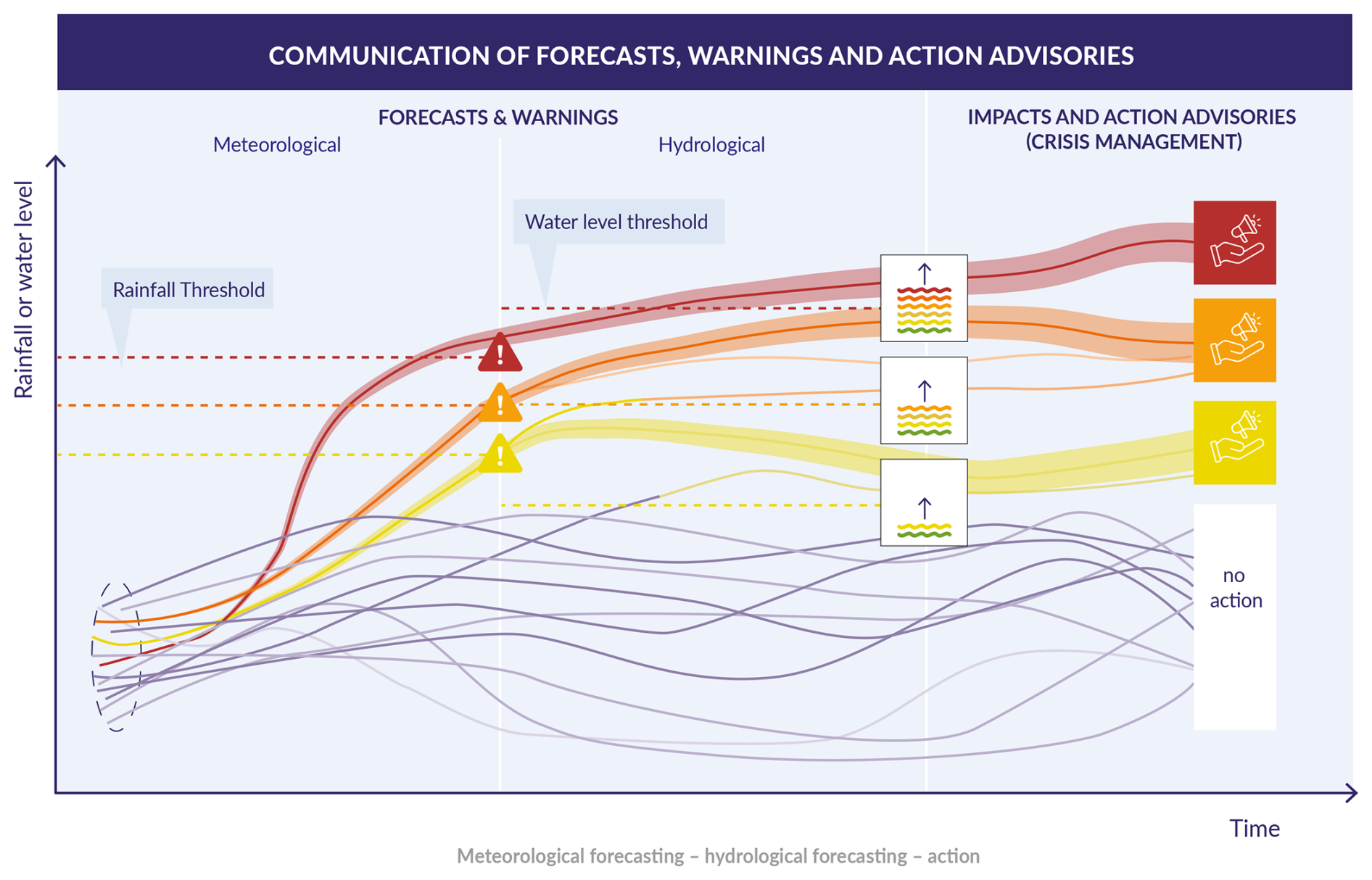
Figure 1Conceptual representation of a Flood Forecasting and Early Warning System (FFEWS). Rainfall ensemble forecasts (left) are used in hydrological models to predict river water levels (middle). Warnings are issued if a share of the ensembles exceed the specified rainfall or water level threshold, which results in triggering (sometimes pre-determined) early actions (right) (adapted from: Busker et al., 2024).
1.1 Flood Forecasting and Early Warning Systems (FFEWS)
A flood forecasting and early warning system (FFEWS) consists of a chain of components (Fig. 1). Hydro-meteorological data are used as input to weather and flood forecasting models, which jointly predict whether warning thresholds are surpassed with a certain probability (e.g. Alfieri et al., 2019). These thresholds can be, for example, pre-defined rainfall amounts or water levels with a certain return period. Surpassing a threshold can lead to a warning to the public or crisis managers who make decisions on how to respond (Fig. 1). Meteorological and hydrological warning levels are often depicted in colours, as shown in Fig. 1. Each warning level can be connected to a set of pre-defined actions, outlined in crisis management plans. Responses at the governmental level include, for example, closing a certain parking garage because it might be flooded, or in severe cases issuing an evacuation alert or order. Households may decide to install flood protection measures such as sandbags or mobile protection systems (Cao et al., 2024).
Uncertainty is present in each component of the FFEWS. In the forecast part, uncertainty can be partially displayed by using ensemble weather forecasts (Fig. 1, left). In addition, uncertainty of forecasts increases with lead time (i.e., the time between issuing a forecast and the real event) – usually one or a few days ahead of the event (Jiang et al., 2023). Further uncertainties in the system lie in the communication, decision-making, and response stages, and whether decision-makers can process warning signals into effective actions on the ground (Bischiniotis et al., 2020). A key challenge in developing and implementing a FFEWS is that uncertainty in one component can cascade down to the next component, all the way to the last component (Parker and Priest, 2012). For example, uncertainty in the collection and processing of meteorological data (Fig. 1, Left) may lead to a “missed” event, where thresholds in the system are not exceeded, while observed water levels reach extreme heights (Cloke and Pappenberger, 2009). By contrast, uncertainties can also lead to so-called false alarms, where predictions suggest that warning thresholds may be exceeded, while in reality they are not.
Numerical weather prediction models have improved greatly in recent decades (Bauer et al., 2015). For example, the Integrated Forecasting System (IFS) operated by the European Centre for Medium-Range Weather Forecasts (ECMWF) showed strong improvements over the last 25 years (Buizza, 2019). The quality of those forecasts is challenged by the inherent uncertainties in atmospheric processes and initial conditions (Leutbecher and Palmer, 2008). The first source of error relates to input data for forecasting models, while the second arises from the imperfect physical parametrization and (coarse) resolutions of models (Buizza, 2019). As with meteorological forecasts, the quality of the hydrological forecasts is affected by various factors, such as meteorological observations or hydrological characteristics (e.g. ground- and soil water volume). Over the last decade, ensemble techniques have been increasingly adopted in operational forecasting centers (Speight et al., 2021; Wu et al., 2020), to estimate forecast uncertainty. Ensemble forecasts are used to determine the probability of certain events, calculated as the share of ensemble members exceeding a pre-determined threshold (e.g. precipitation or discharge). Forecast users can include this probabilistic information in decision-making processes, which makes them more valuable than deterministic forecasts (Richardson, 2003). The ECMWF started with ensemble forecasting in 1992 (Buizza, 2019), and now produce a 51-member ensemble forecast for both the medium-range (15 d ahead) and seasonal range (7 and 12 months ahead), and a 101-member forecast for the sub-seasonal-range (46 d ahead).
1.2 Current challenges in FFEWS
During the 2021 floods, a large share of affected people were not warned (Thieken et al., 2023b, Endendijk et al., 2023a). Moreover, warned people often did not take action due to an underestimation of the severity of the situation (Thieken et al., 2023a). Therefore, research stresses the importance of providing impact and action information in a forecast (Najafi et al., 2024; Kreibich et al., 2021). Impact-based forecasts are more specific and tangible (Merz et al., 2020), trigger a change in people's perception of risk, and consequently their intention to respond (Endendijk et al., 2023b; Red Cross Red Crescent Climate Centre, 2020). In addition, impact-based warnings provide crisis managers and first responders with more tailored information necessary to act (Apel et al., 2022; Boult et al., 2022; Red Cross Red Crescent Climate Centre, 2020; Meléndez-Landaverde et al., 2020, Merz et al., 2020, Rhein and Kreibich, 2025, Poolman et al., 2018). However, the practice of impact-based forecasting is still in its infancy (Merz et al., 2020). Only about 30 % of the national meteorological and hydrological services in Europe use impact-based models (Kaltenberger et al., 2020; Schroeter et al., 2021). Furthermore, many countries and regions have not yet homogenized their FFEWS protocols, which can further hamper clear and consistent cross-border communication (Coughlan de Perez et al., 2022). This is caused, for example, by differences in institutional settings and geographical characteristics in the respective regions. The Council of the European Union states that a better integration of activities and cooperation between countries in cross-border river-basins is crucial to further develop FFEWSs (Council of the European Union, 2024).
1.3 Research gap and aim
Given these challenges, it is crucial to compare and assess the current state of operational FFEWSs. Only very few studies assess operational FFEWSs in detail (e.g. Kaltenberger et al., 2020; Schroeter et al., 2021), and to the best of our knowledge none of them has assessed all components of the FFEWSs chain, including communication and crisis management. Moreover, a transboundary analysis (e.g. an international comparison of warning levels) is lacking. Therefore, the main goal of this study is to assess and compare the FFEWSs in transboundary river basins in Northwestern Europe, based on insights from semi-structured interviews with experts across the region and a literature review. We focus on the areas hit by the July 2021 flood, specifically The Netherlands (Limburg), the Rhineland-Palatinate (RLP) and North Rhine-Westphalia (NRW) federal states in Germany, Belgium (Flanders and Wallonia) and Luxembourg. We intend (a) to compare the institutional and operational characteristics of FFEWSs (e.g. differences in warning levels across countries and communication protocols), (b) to outline and compare the changes made after the 2021 flood event and (c) to develop recommendations to further improve the systems. This will provide a comprehensive overview of the state of FFEWSs and pathways towards translating forecasts to more effective early action.
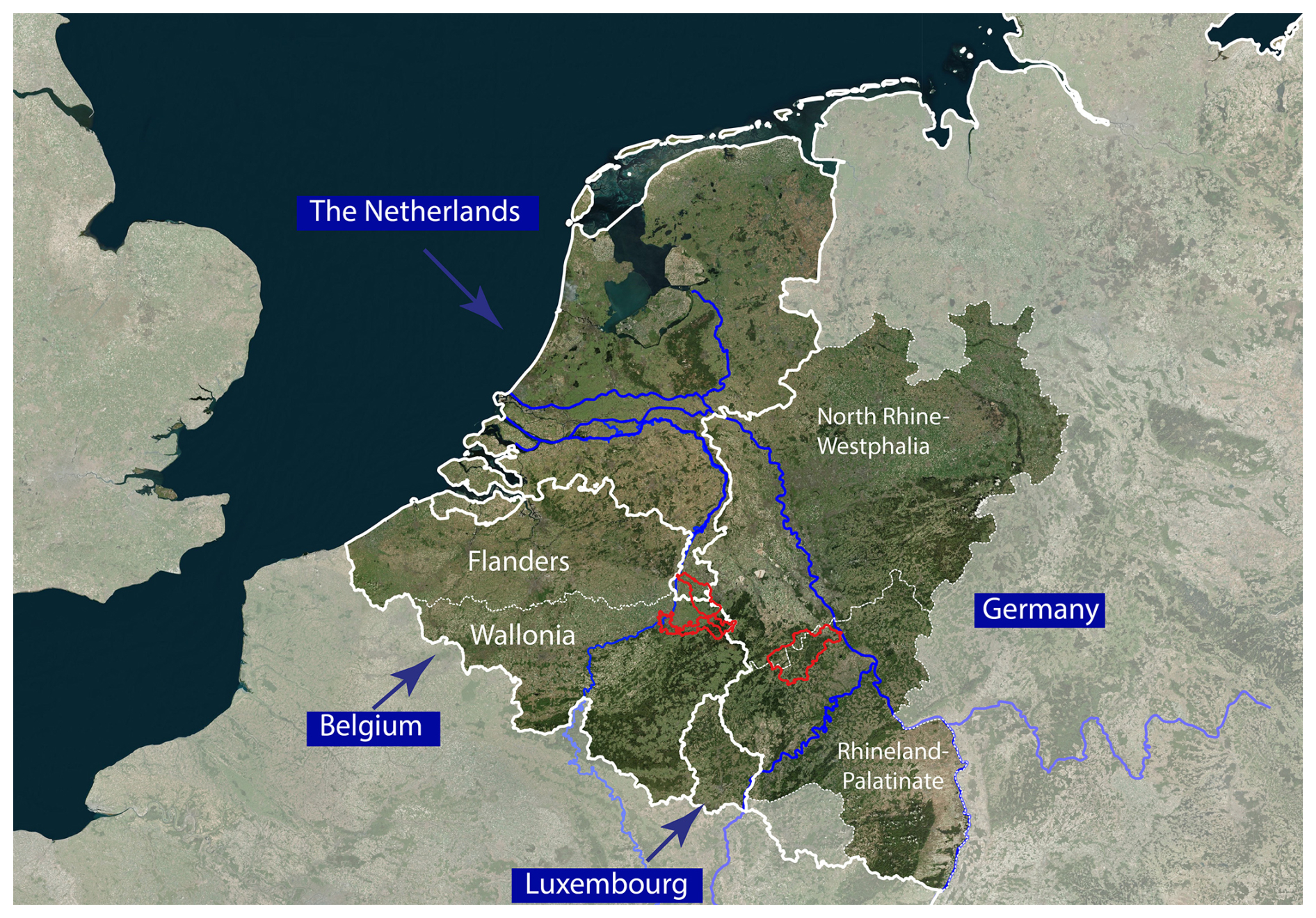
Figure 2The study area in Northwestern Europe with the transboundary Rhine and Meuse rivers, shared by The Netherlands, Germany, Luxembourg and Belgium. These countries and sub-regions were severely impacted by the extreme flood event in July 2021, especially in smaller transboundary tributaries such as the Geul, Vesdre and Ahr (red polygons).
2.1 Case study region
2.1.1 The July 2021 flood event
The summer flood event of 2021 severely hit the area shown in Fig. 2, which is comprised of several countries that share the Meuse and Rhine basins. The event was caused by an atmospheric low-pressure system that delivered a total precipitation amount of about 200 mm in the Ardennes-Eifel region over 48 h (Lehmkuhl et al., 2022; Mohr et al., 2023). The impacts were the largest in the valleys of smaller tributaries such as the Ahr and Vesdre (Fig. 2, red polygons), with the most severe damage in the Ahr Valley, where 135 people lost their lives (out of in total 190 fatalities in Germany; see Thieken et al., 2023b). In Belgium, parts of the Vesdre valley were devastated, while in total 39 people lost their lives (Journée et al., 2023). For The Netherlands, no fatalities were reported, but damage amounted to more than half a billion euros, particularly in the Geul tributary (ENW, 2021). Also in Luxembourg, river gauges recorded unprecedented water levels exceeding the 100-year return period, which led to widespread flooding.
The flood revealed considerable shortcomings in the FFEWSs in the region. Although official evacuation orders or advice were eventually given over most of the region, they were mostly issued too late, just before the peak floodwaters arrived, such as in the Ahr catchment (Thieken et al., 2023a; Rhein and Kreibich, 2025), in the Geul catchment in the south of The Netherlands (Endendijk et al., 2023a), and in the Vesdre catchment in Belgium (Dewals et al., 2021). Moreover, a significant part of the local population in the affected catchments did not receive the warnings. In the Netherlands, 75 % of people with flooded homes in the heavily affected Geul catchment were not warned (Endendijk et al., 2023a). Following an in-depth investigation of official parliamentary documents, Thieken et al. (2023b) showed that around a third of the flood-related fatalities in the German region North Rhine-Westphalia (NRW) were likely not warned. In addition, from the people that were warned, 85 % did not expect severe flooding (Thieken et al., 2023a). In some regions, the flood extended beyond the defined static flood hazard zones (as defined in spatial planning policies), giving citizens a false sense of security, even if they received warnings. This led to households outside of the flood zone being caught by surprise in the NRW and the RLP regions in Germany (Rhein and Kreibich, 2025; Thieken et al., 2023b), and the Walloon region in Belgium (Dewals et al., 2021). Since households living outside the official flood zones have lower risk perceptions, their responses are also lower than those living in flood zones (Aerts et al., 2018). Empirical data in the affected areas in The Netherlands (Limburg) show that households who received a flood warning were 23 % up to twice as likely to take emergency flood risk reduction measures as those who did not receive a warning (Endendijk et al., 2023a). However, this also means that some warned people did not evacuate or take other precautionary measures. These examples show the importance of investing in warning communication. Warning messages should be tailored to users, with information on the expected flood, the expected impacts, and with actionable recommendations for responses (Thieken et al., 2023a).
2.1.2 Governance of Flood Forecasting and Early Warning Systems (FFEWS)
Strong differences in FFEWS governance are present in the study area. In The Netherlands, the national government makes forecasts for the large waterways (e.g., Rhine and Meuse), while regional governments (including regional water authorities: “Waterschappen”) are responsible for the smaller regional water systems. The Netherlands organizes crisis management differently than the other countries: special administrative regions are formed for crisis management, the so-called “Safety Regions” (Dutch: Veiligheidsregios). In Germany, flood forecasting and management is the responsibility of each of the 16 federal States (e.g., Becker et al., 2015). In this study, we focus particularly on flood forecasting and warning deployed in the riparian states of RLP and NRW in Germany. In Belgium, the two federal states (Flanders and Wallonia) have the mandate to develop and enforce flood risk management regulations. In Luxembourg, flood forecasting is addressed at the national level by the Water Management Administration (AGE), which is part of the Ministry of the Environment, Climate and Biodiversity.
2.2 Approach
Most of the information in this study was obtained from key-informant interviews with 14 experts in the countries of the case study area. These experts consisted of senior employees of hydro-meteorological and crisis-management agencies or full professors employed at universities (Appendix A). For every country, we searched for at least one expert in a forecasting agency and one directly involved in crisis management, to ensure diversity in the organizations involved. For the interviews, we developed a semi-structured questionnaire (Supplement) to ask specific questions related to evaluating current FFEWSs. We structured the interview in the five different FFEWS pillars, as outlined by the World Meteorological Organization (WMO, 2023): (1) data collection, (2) forecasting, (3) communication, (4) decision making, (5) action/response. The division of the interview into five pillars facilitated a thematic analysis (Kiger and Varpio, 2020). Within each pillar, we manually synthesized the responses, identifying patterns, commonalities, and differences between the different organizations, based on the audio recordings obtained with the participant's consent. All interviewees were comfortable communicating in English, so it was not necessary to translate the recordings. We included an additional iteration of the synthesized material with most interviewees, to ensure correct interpretation of the interviews. To contextualize our findings, we integrated insights from the literature, comparing our findings with state-of-the-art scientific research. The interviewees provided us with a total of 14 country-specific reports in national languages and 16 scientific articles. To supplement this information, we applied a non-systematic literature review with Google Scholar and Scopus, using (combinations of) these main keywords: #flood, #forecast, #warning, #communication, #response, #evacuation, #residents, #government, #rainfall, #precipitation, #extreme, #waterlevels, #actions, #alerts, #perception, #Belgium, #Luxembourg, #Netherlands, and #Germany. From the search results, we selected 40 peer-reviewed scientific papers and 5 reports from international organizations (e.g. The Red Cross and the WMO). This selection was primarily performed by experts from the region, who were either co-authors or interviewees.
In this section, the key characteristics of FFEWS are presented based on recent literature and expert interviews. First, we present a general overview of the different systems (Sect. 3.1), after which we discuss the warning levels used (Sect. 3.2), a detailed overview per country (Sect. 3.3–3.6), and finally provide an overview of collaborations between the different regions (Sect. 3.7).
3.1 Overview of the operational FFEWS
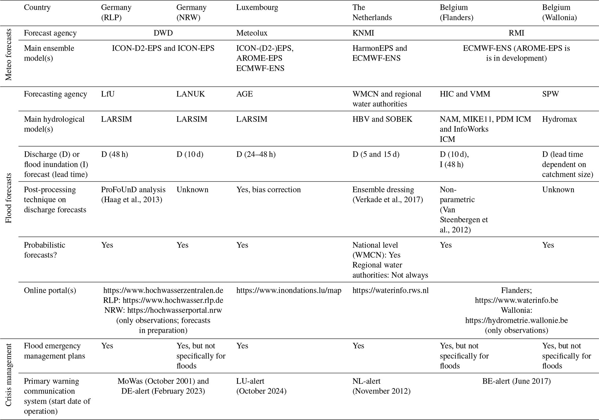
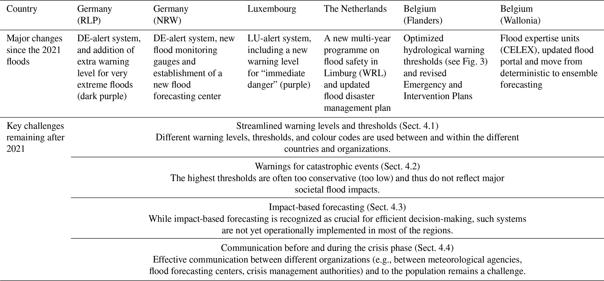
Table 1 summarizes the key characteristics of FFEWS in the region hit by the 2021 flood event, reflecting the state of the systems at the time of this study (5 years after the event). The meteorological agencies use different forecasting systems and all use Ensemble Prediction Systems (EPS) to represent uncertainty (Table 1). The hydrological forecasting agencies also use different hydrological models for flood discharge forecasting. In the German regions RLP and NRW and in Luxemburg, the LARSIM hydrological model is used. Even if the same hydrological model is used, important parameters in the model setup (e.g. spatial resolution; Haag and Luce, 2008) are often user-dependent and can still differ between the different countries. The main forecast models in The Netherlands are HBV and SOBEK, run on the Delft-FEWS system. In Flanders (Belgium), the NAM and MIKE11 models are used for the larger and navigable rivers on the FEWS-Flanders system, and PDM and InfoWorks ICM for the non-navigable rivers. In Wallonia (Belgium), the Hydromax model is most widely used (Table 1). Beyond differences in model types, large differences are seen in the forecast lead time, ranging from only 24–48 h (RLP, Flanders and Luxembourg) to 15 d (The Netherlands). Most operational flood forecasting centers use probabilistic forecasts to account for uncertainty, except for some regional water authorities in The Netherlands. Moreover, they use post-processing methods to correct forecast outputs based on historical forecast errors, aimed at increasing the forecast skill. Flanders is the only region where flood inundation forecasts are run operationally for short-term (48 h) lead times, whereas all other regions rely on discharge forecasts and thresholds. The two lowest rows of Table 1 show information related to crisis management. All regions have flood emergency management plans. In Germany and Luxembourg, a cell broadcasting system was installed in response to and after the July 2021 flood, whereas all other regions had such a system in place prior to the 2021 flood. All regions have online portals with flood warning information, which is updated regularly during flood situations. Publicly available flood forecast information is available via online portals for all regions, except for NWR and Wallonia, where only gauge-based measurements and respective warnings are published.
Table 1Characteristics of Flood Forecasting and Early Warning Systems (FFEWS) in different European regions and countries, reflecting the state of the systems at the time of this study, after the 2021 flood event.
3.2 Warning levels
3.2.1 Meteorological warnings
Meteorological warnings are issued based on clearly defined rainfall intensity and duration thresholds (Fig. 3). The thresholds are chosen based on expected impacts to society and are different across countries. Moreover, as those impacts are highly dependent on the situation (e.g. day or night, location, large events), the thresholds are mostly used only as guidance. The meteorological agencies generally use three rainfall thresholds, except for Luxembourg where four levels are used. In The Netherlands and Belgium, yellow-orange-red colours are used as warning levels. Already before 2021, the German Weather Service (DWD) in Germany issued an additional purple warning for “extreme weather” events. In response to the 2021 flood, Luxembourg implemented a new warning level for “immediate danger” in November 2024, in purple. This warning requires “immediate action”, such as with rapidly-developing flash-floods. For the lowest threshold level, all countries use values of ∼ 30 mm h−1 or ∼ 40 mm per 6 h, whereas the highest threshold is often related to an event of 80 to 100 mm per 24 h (among other thresholds). Only in The Netherlands, the red warning level is not distinguished from orange on the basis of rainfall, but only based on expected impacts. These impacts are estimated in an impact-team meeting with key stakeholders (see Sect. 3.5).
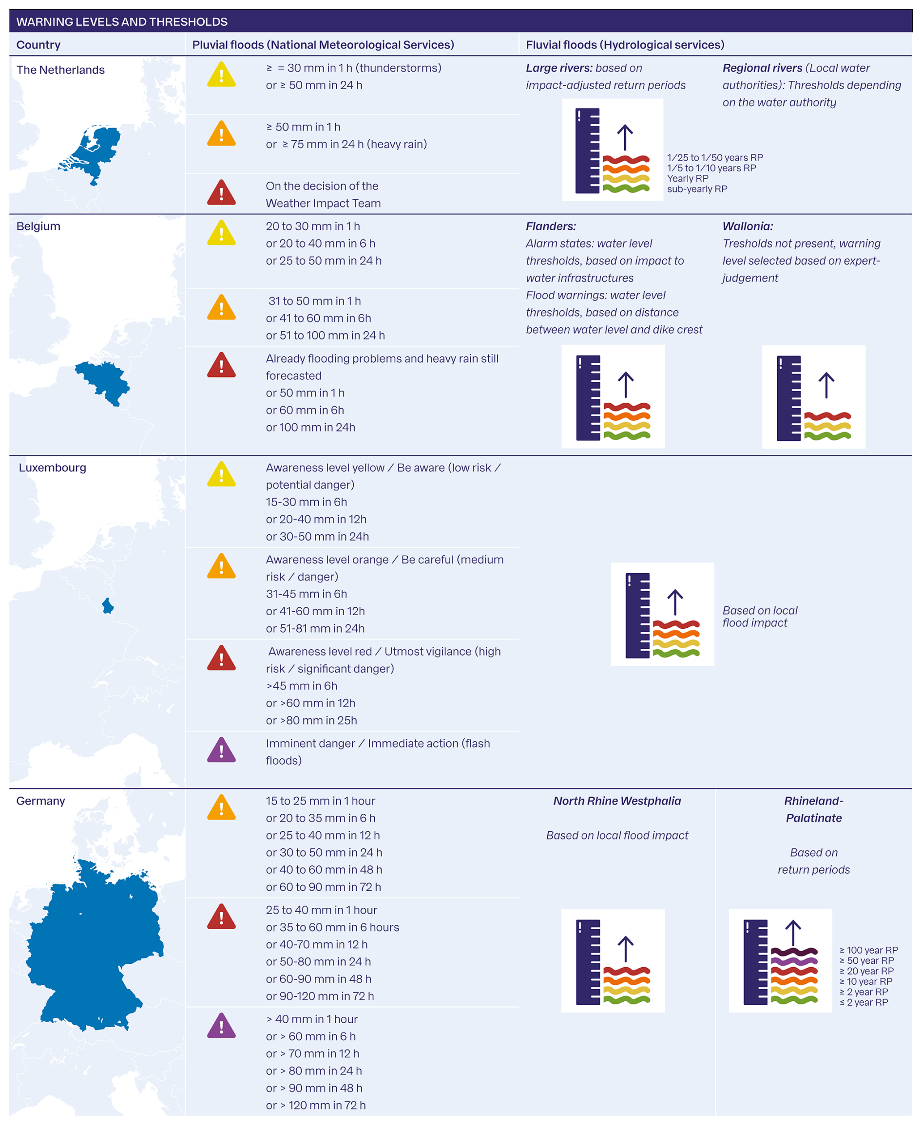
Figure 3Overview of the operational warning levels for pluvial (left) and fluvial (right) floods, as in place five years after the 2021 floods. Colour-coded warning levels are shown, with the corresponding rainfall thresholds (left) and water level thresholds (right). In case the water level thresholds are based on return periods (RPs), the corresponding RP is shown as well.
3.2.2 Hydrological warnings
Figure 3 shows that flood warning levels differ between countries and between regions. For example, Flanders and Wallonia, or NRW and RLP, have different colour codes, which are defined in a different way. The number of hydrological warning levels varies between 3 in Wallonia and 6 in RLP (Fig. 3). Hydrological thresholds are mostly clearly defined in all regions, based on specific discharge or water level thresholds, except for Wallonia. Here, only expert judgement is used to determine the warning level, and the warning thresholds can therefore differ among different events. In the other regions, the thresholds are based on either return periods (e.g., in RLP), or local flood impacts (e.g., in NRW, Luxembourg, Flanders). Warnings in Flanders slightly deviate from the other countries and use different water level thresholds for: (a) Alarm States, based on impact to water infrastructures, and (b) Flood Warnings, based on the distance between the water level and the dike crest (Fig. 3 and Sect. 3.6). Red is the highest warning level in all regions, except for the German federal state RLP. In response to the 2021 flood, the flood forecasting center in RLP (Landesamt für Umwelt Rheinland-Pfalz) subdivided the already existing purple category for extreme events into purple (>1/50 year event) and dark purple (>1/100 year event) to create the opportunity to point out an “extremely dangerous flood event” (Landesamt für Umwelt Rheinland-Pfalz, 2025).
In the following, we provide an overview per country with (a) a general description of the FFEWSs and a more in-depth assessment of the current (b) meteorological and (c) hydrological forecasts, and (d) crisis management and communication, with an emphasis on experiences during the 2021 flood event.
3.3 Germany
3.3.1 General FFEWS setup
Currently, the legal responsibility for weather forecasting, flood forecasting, and response in Germany is split between the German Weather Service (DWD), flood forecasting centers in the federal states (Länder), and flood emergency management in the counties (Landkreise), respectively. The DWD is mandated to produce weather forecasts and issue severe weather warnings. The federal state flood forecasting centers translate the weather forecast into hydrological forecasts and disseminate warning messages for affected catchments. In April 2024, the Federal Act on the DWD (Gesetz über den Deutschen Wetterdienst) was changed, allowing the DWD to disseminate warnings other than severe weather warnings, which include flood warnings. In 2025, a national natural hazards online portal was released to share this information (https://www.naturgefahrenportal.de, last access: 17 January 2026). Local emergency management authorities interpret information from forecasting agencies and translate it into impact-specific warnings and are responsible for decision making and triggering specific emergency actions, such as evacuation. Warnings are disseminated to the public via the centralized Modular Warning System (MoWaS), operated by The German Federal Office of Civil Protection and Disaster Assistance (BBK).
3.3.2 Meteorological forecasts
In Germany, DWD uses two ensemble forecast models, the ICON-D2-EPS (for the next 48 h) and ICON-EPS (for the next 7.5 d). More recently, DWD has developed a “seamless” forecasting system to better forecast small-scale convective events and flash floods, called SINFONY. This system integrates ensemble weather forecasts and nowcasting techniques (based on real-time radar measurements) over shorter lead times (Blahak, 2024). The DWD forecasts are sent to the environmental offices and flood forecasting agencies of the federal states and to water associations (“Wasserverbände”). These contain a description of the characteristics of severe weather events and the amount of expected precipitation. The thresholds and warning levels for heavy rainfall as used by the DWD are summarized in Fig. 3.
3.3.3 Hydrological forecasts
The ensemble flood forecasting models are operational in 10 flood forecasting centers in federal states. In addition to those, regional flood forecasting centers are in operation, specifically for large navigable rivers such as the Rhine. The locations of gauging stations at which the hydrological discharge and water level forecasts are issued are provided by the German Working Group on water issues of the federal states (LAWA-Commission; LAWA, 2020). The national web portal (Table 1) was established after the severe flood in August 2002 and provides an overview of the gauges with up-to-date flood forecasting and warning information. Moreover, it serves as a gateway to the specific web services of flood forecasting centers in the federal states. It also distributes written interpretations of the forecasts (in the so-called “Lageberichte”). The LAWA (2020) report also contains a detailed overview of the frequency of forecast updates for specific gauges in case of flooding, which typically ranges between 2 and 24 h. In Germany, many regional and federal state forecasting centres use a variety of different hydrological models and warning configurations (Demuth and Rademacher, 2016). The environmental office in RLP (Landesamt fur Umwelt, LfU) is responsible for flood forecasting. They issue forecasts and warnings with a 48 h lead time, based on a 20-member ensemble forecast from the DWD ICON-D2-EPS model. LfU uses a post-processing method to correct model outputs, based on the Forecast Uncertainty of Discharge (ProFoUnD) analysis (Haag et al., 2013). The forecasts are updated every three hours, which is the same frequency as the DWD forecasts. In NRW, the responsibility for flood forecasting belongs to the Landesamt für Natur, Umwelt und Klima Nordrhein-Westfalen (LANUK). A new flood forecasting center was formed in LANUK, as a response to the 2021 floods. Currently, water level observations at some gauges in NRW are accessible in near-real-time, but forecasts are not publicly available (Table 1). In NRW, LANUK runs operational hydrological ensemble forecasts every 3 h. These predictions are based on the Large Area Runoff Simulation Model (LARSIM) hydrological model and use weather forecast data from the ICON-D2-EPS (20 ensemble members) and ICON-EPS (40 ensemble members) models. The two regions, NRW and RLP, use different colour codes and warning levels (Fig. 3). Although the warning thresholds in RLP are based on water level return periods, the thresholds in NRW are based on local impacts on buildings and communities. NRW defines four different warning levels, while RLP uses six. NRW is in the process of adding an additional purple warning level as well, which represents a risk of catastrophic floods. This would better streamline the hydrological warnings of NRW and RLP and the meteorological warnings from DWD, which also include a purple level (Fig. 3). In addition to some prototypes in pilot areas, near-real-time flood inundation and impact forecasting are not yet implemented in the operational flood forecasting and warning systems in Germany (Merz et al., 2020).
3.3.4 Crisis management and communication
Warnings from the federal hydrological flood forecasting centers (e.g. LANUK in NRW) are sent to the county (Landkreis) crisis response centers. Based on laws regarding general civil assistance and disaster management, all counties, municipalities, and independent cities in Germany, which are not affiliated to a county, are required to have a disaster management plan (DKKV, 2024; Ministerium des Innern und für Sport Rheinland-Pfalz, 2020). RLP has developed a specific flood emergency management plan: the Rahmen-, Alarm- und Einsatzplan Hochwasser (Ministerium des Innern und für Sport Rheinland-Pfalz, 2020). The county crisis response centers, not the federal state hydrological forecasting centers, are responsible for dissemination of the warnings to the public.
Both DWD and flood forecasting centers can activate MoWaS in case of an expected catastrophic flood and further disseminate information to other channels such as warning apps (Meine Pegel, NINA or KATWARN), radio and television (IIASA, 2022). Since February 2023, the population can be warned using a new cell broadcasting system (DE-alert), which does not require the installation of an application and is connected to the MoWas system. In terms of online information, residents show a clear preference for maps in warning messages (Lindenlaub et al., 2024a).
3.4 Luxembourg
3.4.1 General FFEWS setup
Meteorological forecasts are used by the flood forecasting department (Service de prévision des crues) of the water management authority (Administration de la gestion de l'eau, AGE). The AGE produces forecasts for the main river systems (the Alzette, Chiers, Moselle, Sûre and Syre), but also for the Mosel in France, which are publicly available via the web portal (Table 1). In case of a large flood, a crisis team is activated to coordinate emergency management activities. Civil protection measures and the organization of the response during floods are carried out by the national fire brigade: the Corps Grand-Ducal D'Incendie et de Secours (CGDIS). In November 2024, LU-alert was launched, which is a new national warning system based on cell-broadcasting alerts and geo-located SMS services on mobile phones (Le gouvernement du Grand-Duché de Luxembourg, 2025). The SMS service has the additional advantage that it enables one to monitor the number of people in a certain area, which CGDIS can use to monitor how many people have been evacuated. This system was launched in response to the flood of 2021. With the launch of this new system, Luxembourg also added a new purple warning level for events with “immediate danger” that require “immediate action”, such as for flash floods. This new purple level can be issued by the meteorological agency (Meteolux) and the crisis management, but not by the hydrological agency AGE (see Sect. 4).
3.4.2 Meteorological forecasts
The national meteorological service Meteolux does not run its own weather model but instead uses different weather models from ECMWF, DWD and MeteoFrance, like the ICON-(D2-)EPS, ECMWF-ENS, and AROME-EPS. A severe weather risk assessment unit (Cellule d'évaluation du risque intempéries, CERI) can be initiated to estimate the societal impacts. The CERI includes representatives from the AGE, MeteoLux, the national government (Haut-Commissariat à la protection nationale), and CGDIS. As described above, Meteolux adopted new warning levels in November 2024: yellow-orange-red-purple (Fig. 3).
3.4.3 Hydrological forecasts
Hydrological forecasts and warnings are provided by the flood forecasting department of AGE. They use a wide range of meteorological forecasts as input, from DWD, ECMWF, and MeteoFrance. The ensemble forecasts are made with the LARSIM model and can be updated every hour. They have a lead time of 24 h for smaller streams and 48 h for the large rivers (e.g., Moselle, Lower Sauer). Ensemble discharge forecasts are optionally bias-corrected for current observation–simulation differences in discharge, soil moisture, precipitation, and temperature. They are generally updated every three hours during normal situations and every hour during emergencies. AGE only publishes the deterministic forecasts on the portal, while multi-model ensemble forecasts are used internally. Warning levels in Luxembourg have recently been revised and AGE now uses three different levels: yellow (“Cote de vigilance”), orange (“Cote de pré-alerte”) and red (“Cote d'alerte”). However, the hydrological service (AGE) is not mandated to issue a purple warning in the new system. This is reserved for the meteorological forecasting service or crisis management. Interviewees from Luxembourg stressed that the new warning levels are based on the expected impact, derived from flood maps and/or consultations with local authorities and firefighters (Fig. 3).
3.4.4 Crisis management and communication
Luxembourg has a specific emergency management plan for extreme weather and floods (Le gouvernement du Grand-Duché de Luxembourg, 2025). During regular floods, the flood response is managed by CGDIS, which is in constant exchange with the flood forecasting service. When the flood risk is deemed high, a Crisis Cell is activated, led by the High Commission for National Protection (HCPN) which comprises representatives from various bodies, such as the Police, Army, and Government. During a crisis, the AGE flood forecasting department is in constant exchange with CGDIS and the High Commission for National Protection (HCPN). The HCPN manages the actions required during a crisis (European Commission, 2024). Four crisis management phases are specified: normal, vigilance, pre-alert, and alert (Le gouvernement du Grand-Duché de Luxembourg, 2025). Those are in line with the hydro-meteorological warnings described above. In the “pre-alert” phase, local flooding is expected and in the “alert” phase widespread flooding is expected with a significant impact on people and property (Le gouvernement du Grand-Duché de Luxembourg, 2025). These alert phases are also coupled with specific water levels. In the “(pre-)alert phase”, flood bulletins are circulated that include warnings and a textual interpretation. In the “alert phase”, the prime minister (or his/her delegate) can activate a Crisis Unit Cell (Le gouvernement du Grand-Duché de Luxembourg, 2025). The CGDIS pointed out that the procedures have improved greatly since the floods in July 2021. For example, before the 2021 flood event, communication between municipalities and CGDIS often failed. Today, flood alerts are sent to local fire stations along with a request to contact the (deputy) mayor of the municipality.
3.5 The Netherlands
3.5.1 General FFEWS setup
The Royal Netherlands Meteorological Institute (KNMI) is responsible for severe weather warnings in The Netherlands. KNMI and national hydrological forecast information is transmitted to regional authorities, such as the regional water authorities (Dutch: “Waterschappen”), who are responsible for forecasts in smaller streams and catchments. They advise crisis management organizations (the so-called “Safety Regions”) about risk and implementation of protection measures.
3.5.2 Meteorological forecasts
Among the meteorological models used are the HARMONIE-AROME (Frogner et al., 2019) and ECMWF (Haiden et al., 2018) weather models. The HARMONIE model provides hourly forecasts, and the ECMWF model provides 6 h forecasts. The version of HARMONIE ensemble model is called HarmonEPS, which produces a subset of ensembles at each run every hour (“a running ensemble”). This is different from ECWMF-ENS, which runs full ensembles every 6 h. Meteorological warnings are classified into the yellow-orange-red colour code (Fig. 3). The KNMI developed an in-house system to calculate maps of exceedance probabilities for an ensemble weather forecast: the Probabilistic Alert System for the Concurrence of Adverse Weather Elements (PASCAL) system (Kok, 2022).
The KNMI works towards impact-orientated forecasting. To improve knowledge and experience on those impact-orientated forecasts, the KNMI launched an Early Warning Centre in 2015. In case an orange or red warning is predicted by the ensemble models (>60 % probability), the KNMI initiates an online multi-disciplinary weather-impact team meeting. This team includes key organizations such as ProRail, the National Crisis Centre (NCC), the Netherlands Traffic Center (VCNL) and the National Operational Coordination Centre (LOCC). This team provides advice to the KNMI on the selected warning level, which is in practice always followed. The stakeholders in the team also fill in an impact questionnaire, which results in an impact score per economic sector. The final warning level is decided by the operational lead at the KNMI. To allow for an early engagement of the impact team, the KNMI can already inform the impact team up to seven days in advance when a warning is not yet generated, but possible (using a 30 % probability threshold). In case a rainstorm is predicted only at the last moment, the KNMI issues a warning without first consulting the impact team.
3.5.3 Hydrological forecasts
The national Dutch Water Management Center (WMCN) produces 5 d (validated) and 15 d (automatic) forecasts for the river Rhine (gauge Lobith) and the river Meuse (gauge Sint-Pieter), using the HBV and SOBEK models. Those models are run on the Delft-FEWS platform for the whole (international) Rhine and Meuse basins. Forecasts 5 d ahead are deterministic, while the 15 d forecasts are ensemble products. These forecasts use multiple weather models as input: DWD COSMO-LEPS model, DWD ICON-EU, DWD ICON, the ECMWF-ENS, and ECMWF-HRES (deterministic) forecasts. Meteorological uncertainty is included using ensemble forecasts, where every member of the ensemble is used as input to the hydrological model. For a small portion of the stations (approximately 5 %), a post-processing technique is used on the discharge forecasts (Verkade et al., 2017) to include the hydrological uncertainty. This is done by correcting (“dressing”) an individual streamflow ensemble member based on historical hydrological model errors. In addition, the WMCN uses forecasts from the European Flood Awareness System (EFAS; Smith et al., 2016), which is part of the Copernicus Emergency Management Service. Regional water authorities (Dutch: “waterschappen”) run forecasts for the smaller Dutch rivers and tributaries. However, not all water authorities run forecasting models operationally and many different models are used.
The Dutch national protocol for high waters and flooding (LDHO) provides an overview of the different warning levels for the Dutch main rivers (WMCN, 2023). Four warning levels are in place (Fig. 3): green, yellow (elevated water levels, water nuisance possible), orange (high waters) and red (extreme high water). These are based on both the water level and the discharge thresholds, and expressed as return periods (WMCN, 2023, Appendix D). Different return periods apply to different rivers, since the strength of the dikes is different (WMCN, 2023). Therefore, Fig. 3 displays the ranges of return periods. The exact return periods per river can be found in WMCN (2023, Appendix D). As multiple ensemble forecasts are made (using multiple models), expert judgement is needed to determine which warning level is ultimately selected.
In case of orange or red warnings, an expert group gathers into a national committee: the Landelijke Commissie Overstromingsdreiging (LCO). These experts in meteorology and hydrology translate the water level forecasts into impacts and advise on required interventions. The LCO is mandated to evaluate the colour code selected by the WMCN and can increase the warning level if deemed necessary (e.g., in case of calamities, such as failures of water infrastructures). As a result of these decisions, information in a web-portal (Table 1) is updated and disseminated every day, including the hydrological forecasts, warning levels, and a textual interpretation. In case of orange and red warning levels, the online information can be updated multiple times per day. The orange warning level can be issued with a maximum lead time of 48 h. However, stakeholders can be informed up to 7 d in advance with a notice that the threshold will potentially be exceeded.
On the local scale, regional water authorities (“Waterschappen”) and Safety Regions are responsible for hydrological forecasting and responses, respectively. For example, the water authority in Limburg (Waterschap Limburg) runs operational forecasts to predict discharge and/or water levels, with a lead time of 5 d. Predictions are deterministic, although the Waterschap Limburg stressed in the interview that there is a strong need and desire to develop operational probabilistic forecasting approaches. In Limburg, a variety of activities were triggered in response to the 2021 flood. A new large programme on flood safety called “Waterveiligheid en Ruimte Limburg (WRL)” was launched in 2022. In this programme, local authorities and the central government are working together to improve Limburg's flood resilience. As part of WRL, a separate early warning project has been started to improve the warning system of the regional water authority (Waterschap Limburg). This leads to input for developing a new impact-based forecasting system of the Waterschap Limburg and the Safety Regions.
3.5.4 Crisis management and communication
The Safety Regions are regional organizations responsible for the management of crises of various types of hazards and the provision of information to the population. The Netherlands is the only country with such administrative units specifically designed for crisis management. Based on the estimation of LCO and the Departementaal Crisis Centrum (DCC) of the Ministry of Infrastructure and Water Management, the Safety Region and other stakeholders can be warned through the National Crisis Management System (LCMS). Actions (e.g., dike inspections) are linked to warning levels, which are detailed in WMCN (2023) for large rivers and regional water authorities protocols for small rivers. Some regions in The Netherlands have a dedicated emergency management plan for floods. Limburg province updated the flood disaster management plan (Rampbestrijdingsplan Hoogwater Limburg; Veiligheidsregio Limburg-Noord and Zuid-Limburg, 2023) after the 2021 floods, by including clear warning thresholds for the smaller rivers. Those are identified based on the expected nuisance to the (urban) surroundings and thus take the strength of the dikes and the exposed assets into account (Veiligheidsregio Limburg-Noord and Zuid-Limburg, 2023). In case of a flood crisis, the Departmental (DCC) or National Crisis Management Center (NCC) coordinates the crisis, and the LCO advises on measures to take (WMCN, 2023).
The public is warned through multiple channels, of which the most important are NL-ALERT (Table 1) and the 4278 air raid alarm systems. The KNMI also actively disseminates warnings through the newly developed KNMI app and through social media. They have a clear approach to warning that is impact- and action-orientated (see Sect. 4.3).
3.6 Belgium
3.6.1 General FFEWS setup
The meteorological forecast and warnings for Belgium are produced by the Royal Meteorological Institute of Belgium (RMI). River discharge forecasts are generated separately for Flanders and Wallonia, using RMI forecasts as input. The National Crisis Center (NCC) is responsible for managing national level crisis situations.
3.6.2 Meteorological forecasts
In the RMI, the deterministic meteorological forecasts are produced by the ALARO model (Gerard et al., 2009). Currently, ensemble forecasts from the ECMWF-ENS system are used and the RMI develops a new ensemble system (AROME-EPS; Frogner et al., 2019) (Table 1). However, operational meteorologists also use other models from other agencies such as the UK Met Office and DWD. Warnings are generated using yellow-orange-red colour codes at the provincial level (Fig. 3). Warnings are issued if more than 65 % of the ensembles exceed the rainfall threshold for a specific colour over more than 25 % of the provincial area (Fig. 3). A warning for a given colour can also be issued if either of the following conditions is met: (1) the threshold for the next higher colour is exceeded by more than 65 % of the ensembles, even if this occurs over less than 25 % of the area; (2) the threshold for the next higher colour is exceeded by 15 %–65 % of the ensembles over more than 25 % of the area. These are guidelines, but the RMI can deviate from those based on the expected impact. The impacts are discussed in online impact team meetings, which can be called 2–3 times a day during severe weather conditions. These meetings involve the hydrological centers for Wallonia and Flanders (SPW and HIC/VMM, respectively), fire brigades, regional and national crisis centers and provincial governors. Although the RMI takes impacts into account in selecting the warning levels (e.g., a rainstorm approaching a festival), the interviewee stressed that the RMI is not mandated to provide impact- or action-oriented advisories. Four radars provide near real-time observations for nowcasting using the INCA-BE system. This system allows for the generation of so-called “flash warnings”, which are automatically generated warnings at the local level (i.e., municipal) with <1 h lead time (Smet, 2017). These warnings are disseminated via the RMI app.
3.6.3 Hydrological forecasts
In Flanders, the Hydrologische Informatie Centrum (HIC) is responsible for monitoring and forecasting of navigable waters. The non-navigable rivers (category 1) in Flanders are monitored and forecast are issued by the Vlaamse Milieumaatschappij (VMM). Those observations and forecasts are publicly available on the official Waterinfo web-portal (Table 1). The HIC produces medium-range (10 d) and short-term (48 h) forecasts using the hydrological-hydraulic model NAM-MIKE11, run on the platform FEWS-Flanders. The long-term forecasts are based on deterministic ICON/ECWMF forecasts (2 times daily), while the short-term forecasts are derived from deterministic ALARO model runs (4 times daily). The HIC has six hydrodynamic models for different catchments: (1) IJzer, (2) Leie and its drainage channels, (3) Dender, (4) Zenne-Zeekanaal, (5) the Scheldt estuary and (6) Demer. These models provide flood forecasts, which are also visualized in the web-portal and disseminated to partners. Apart from the Demer river, HIC runs the FFEWS for Flanders 4 times per day with input from the ALARO model of RMI. The rainfall forecasts used as input for the hydrological model are deterministic. Probabilistic discharge forecasts are made using a hydrological post-processing technique, based on historical lead-time dependent model errors (Van Steenbergen et al., 2012). Two types of warnings can be generated 48 h in advance for both the navigable and non-navigable rivers: alarm states and flood states. These warnings both follow the green-yellow-orange-red colour codes, for both navigable (provided by HIC) and non-navigable (provided by VMM) rivers. The flood warning states (Fig. 3) are visualized in the so-called “Vrijboordkaarten” and show the distance between the water level and the dike crest. The colours reflect the following situations: green: no floods; yellow: pre-warning; orange: warning, non-critical flooding would be possible; red: alarm, critical flooding would be possible. These flood warning states are based on water-level thresholds determined by the hydrological-hydraulic model forecasting results. The alarm states, on the other hand, are determined based on the impact on water structures (e.g., bridges), but do not reflect overall flood impacts to society. The forecasts and warning levels are displayed in near real-time on the Waterinfo portal (Table 1). In case of high discharges, the warnings are actively distributed to the water authorities, which distributes the warnings to other stakeholders and emergency management. After the 2021 flood, the hydrological warning thresholds have been changed for the navigable rivers in consultation with De Vlaamse Waterweg, mainly to better streamline thresholds among the different regions of Flanders.
In Wallonia, the Direction de la Gestion Hydrologique (DGH) of the Walloon government public service (Service Public de Wallonie, SPW) is responsible for monitoring, forecasting and warnings. The DGH operates the Hydromax model using a network of 150 river gauge stations and 100 rain gauges (the “Wacondah” network) as input (DGH, 2024). Hydrological forecasts are made using deterministic weather forecasts from different ALARO models. In response to the 2021 flood, ensemble weather forecasts from ECMWF-ENS are also used. Five different percentiles are selected from the 51-member ECWMF ensemble and used in Hydromax to produce hydrological forecasts, which are further post-processed considering forecast errors of previous floods (DGH, 2025). The main non-navigable rivers (e.g., the Vesdre) are monitored by the Direction des Cours d'Eau Non Navigables (DCENN), which operates a measurement network called “Aqualim” (DGH, 2024). Warnings follow a green-yellow-red colour code (Fig. 3) and are issued at the sub-catchment level. Yellow warnings are issued if one (or more) rivers in a sub-catchment are expected to cause localized and non-severe floods, and red warnings if one or more rivers in a sub-catchment are expected to cause major floods with an impact on infrastructure and local residents. The thresholds are not prescribed but are defined by expert judgement based on catchment wetness state, precipitation forecasts, discharge in the upstream rivers and tributaries, and past experience. Observations and flood warnings are displayed on the web-portal of the Walloon government (Table 1). The portal was updated after the 2021 flood, and now also includes the non-navigable waterways (from the Aqualim network). None of the governmental hydrological and crisis management agencies in Wallonia produce inundation forecasts operationally. However, inundation forecasts are produced for some pilot river sections; but currently these forecasts are not communicated to the public, as they do not consistently cover the whole river network.
3.6.4 Crisis management and communication
Crisis management in Belgium is organized at three levels: municipal, provincial, and federal state level. At the federal level crisis management is coordinated by the Centre de Coordination des Risques et de la Transmission d'Expertise (CORTEX) for Wallonia and the Crisiscentrum van de Vlaamse overheid (CCVO) for Flanders.
In Wallonia, in case of an orange warning, CORTEX calls a special flood expertise unit (CELEX) by videoconference. The CELEX unit was launched in response to the 2021 flood event. In case of (pre-) alerts, CELEX develops and shares flood reports with stakeholders (but not with the general public). These reports include an outlook on the consequences and the required actions. In Flanders, each province has an Emergency and Intervention Plan (NIP), which was revised after the 2021 flood and is regularly exercised. In case of a large flood disaster, such as in 2021, the federal level is initiated and the National Crisis Center (NCCN) takes over the coordination. The RMI can directly send meteorological warnings to the NCCN. Furthermore, every municipality in Wallonia should have a general emergency management plan (Plan Général d'Urgence et d'Intervention; PGUI). In May 2025, the Walloon government installed a Regional Crisis Management Plan, which can also be applied during flood crises (Government of Wallonia, 2025). Since June 2017, the public can be warned via the mobile cell broadcasting system: BE-ALERT (Table 1).
3.7 Coordination and data sharing across borders
All interviewees emphasized that data exchange between countries is already quite well organized. For example, the border between The Netherlands and Flanders is marked by the lower part of the Meuse river (“Grensmaas”). To provide a consistent warning for all households along the Grensmaas, Flanders adopts the warning levels used in the Netherlands. In addition, the Dutch water management center (WMCN) uses both European data from the EFAS system and additional hydrological information from neighboring countries. In Germany, the exchange of meteorological and hydrological data and forecasts is well organized. Data are exchanged between different federal states and different neighboring countries (Poland, the Czech Republic, Austria, Switzerland, France, Luxembourg, and The Netherlands) in near real-time (Demuth and Rademacher, 2016; LAWA, 2020). Several international agreements are in place to foster collaboration in transboundary river basins. The International Commission for the Protection of the Rhine (ICPR) fosters collaboration between the different states in the Rhine basin and organises annual plenary assemblies. In 1987, the Internationale Kommissionen zum Schutz der Mosel und der Saar (IKSMS) signed an intergovernmental agreement between France, Germany, and Luxembourg to improve flood detection and forecasting in the Saar and Moselle catchments (IKSMS, 2025). This strong collaboration results in hourly data sharing from rain gauges, discharge gauge stations, precipitation radar data, and weather forecasts between all flood forecasting centers (IKSMS, 2025). Moreover, joint data assimilation systems (such as the PLATIN data exchange server), models and forecasting systems are developed, technical trainings are organized, and language courses are offered to improve communication (IKSMS, 2025). Other transboundary basins, especially for the smaller rivers, can learn from this strong and long-lasting collaboration agreement.
Although transboundary collaboration was not identified as a major issue in the FFEWS chains, some concerns were raised in the interviews. While sometimes common models are developed (such as mentioned above), too often different meteorological and hydrological models are used in different countries (see Table 1) which can result in inconsistent and conflicting information to stakeholders in transboundary regions. Furthermore, some important data are not always shared (efficiently). For example, HIC in Flanders mentioned the need to improve the exchange of information about upstream reservoirs in Wallonia. Often, information about reservoir levels is not shared, especially for energy-producing reservoirs (for energy companies, such as ENGIE). In addition, Waterschap Limburg interviewees stressed the importance of an international exchange of flood warnings, which is currently lacking. These challenges highlight the need to continue efforts to streamline transboundary collaboration.
The interviews reveal that the FFEWSs in all regions are under strong and rapid development after the 2021 flood (Table 2). All regions now have flood emergency response plans and use cell-broadcast services to alert the population. In NRW, a new flood forecasting center has been established at LANUK and 26 new flood monitoring gauges have been installed (LANUK, 2025). Moreover, all regions defined clear thresholds for the different hydrological warning levels, except for Wallonia (Fig. 3). In autumn 2023, the flood forecasting center (LfU) in the RLP region added a new warning level for very extreme floods (>100-year return period) with a dark-purple colour (Fig. 3). The flood forecasting center of Flanders (HIC) optimized its warning thresholds in close collaboration with stakeholders, such as the Vlaamse Waterweg waterways authority, and many provinces updated their Emergency and Intervention Plans. In Wallonia, a flood expertise unit (CELEX) has been established after the 2021 floods, which can provide tailored flood impact advice during crises. Furthermore, ensemble forecasts are now used to produce flood forecasts and the web-portal for floods has been renewed. In Limburg, the flood disaster management plan (“Rampbestrijdingsplan Hoogwater Limburg”) now includes flood scenarios for small rivers (e.g. the Geul river), including clear warning thresholds and the corresponding actions. Moreover, a large programme has been launched in 2022 to improve flood safety: Waterveiligheid en Ruimte Limburg (WRL). In November 2024, Luxembourg implemented a new alerting system (LU-alert) and streamlined the warning system, by adopting the same warning levels and colour codes for meteorological forecasts and crisis management alerts. This includes a new level for “immediate danger” with a purple colour. Even after those changes, the interviewees identified several issues that require attention to further improve FFEWSs (Table 2, bottom). We will further outline those challenges below.
Table 2Most important changes of the Flood Forecasting and Early Warning Systems (FFEWS) triggered in response to the 2021 flood, and the key challenges remaining in different European regions and countries.
4.1 Streamlined warning levels and thresholds
The first challenge relates to the transboundary differences in meteorological and hydrological warning levels and their thresholds. In general, the number of warning levels, their colour and the thresholds used differ between the different countries (Fig. 3). Moreover, they frequently also differ within the different regions of a country and between the meteorological and hydrological agencies of a country (Fig. 3). For example, the number of warning levels and their colour codes are different in the two federal states of Belgium: Flanders and Wallonia (Fig. 3). In Luxembourg, MeteoLux and CGDIS apply a purple warning level for events posing immediate danger (Fig. 3). They are mandated to do so because both maintain permanent operational offices. Although this level is also used by LU-Alert and the crisis management, the flood forecasting center (AGE) is not mandated to use this level as it does not operate 24/7. In addition, in Germany, the warning levels are not consistent among federal states. For example, in RLP they are linked to flood return periods and in NRW to flood impacts (NRW, 2024) (Fig. 3) – the latter does not necessarily correspond to the same return periods as in the neighboring RLP (DKKV, 2024). Although RLP now distinguishes six warning levels, other German states use just four (like NRW), including a green level for no warning (Fig. 3). Moreover, the “red” colour being the highest warning level in some flood forecasting centers in Germany (e.g., LANUK in NRW) is inconsistent with the highest “purple” weather warnings from DWD. The interviewees in RLP also state that the number of alerts by DWD was high in the past and that it could be difficult for the recipients to estimate if a warning indeed results in a flood. Furthermore, DWD warnings are generally cleared at the end of a precipitation event, while flood warnings can still be active because the flood did not yet end. According to the interviewees, this situation occurred in 2021 and confused local stakeholders. Research shows that inconsistent visual and textual warnings from multiple sources are confusing to decision-makers and the public, which can lead to ineffective communication and actions (Weyrich et al., 2019). Moreover, it is important to note that the underlying hydrological models are often different between and within (e.g. Wallonia and Flanders) different countries. Those models are deployed on a wide range of different forecast lead times (ranging from 48 h to 15 d). We recommend evaluating the consequences of the above inconsistencies for improving early warning communication.
4.2 Warnings for catastrophic events
After the 2021 flood, some regions started a discussion to introduce a new (or additional) colour code for extreme floods. In the German federal state of the RLP, this discussion has led to the adoption of an additional “dark purple” level in addition to the “purple” level in Autumn 2023, based on a 100-year return period threshold (Landesamt für Umwelt Rheinland-Pfalz, 2025). This adjustment was primarily made to improve communication possibilities for “extremely high danger of flooding”. However, recent research suggests that even the purple DWD warnings for the 2021 event were too abstract and that people did not associate the warning with such an extreme flood event (Ommer et al., 2024). The warning levels for Luxembourg also contain a new purple level, which can only be issued by the meteorological service MeteoLux and not by the flood forecasting center AGE (Fig. 3). The highest warning level of AGE is “Cote de vigilance rouge” (Red), which is often linked to small return periods. For example, the gauge Bollendorf in the Sauer has a red warning threshold related to a water level of 4.25 m, which corresponds to less than a 5-year return period event. This suggests that extreme river floods could be better represented in the new warnings. Our interviewees in Wallonia stated that “… there should be a new discussion about the need for an extra level of warning (e.g. dark red) for really extreme situations”. For the regional water authority in Limburg (Waterschap Limburg), the highest warning level (red) is described as a “water nuisance” for people, rather than a high-impact catastrophic event (Veiligheidsregio Limburg-Noord and Zuid-Limburg, 2023). However, more extreme thresholds come with more uncertainty. Rare events will typically be predicted with only a few ensemble members. These low-probability and high-impact forecasts bring considerable decision-making challenges (Speight et al., 2021), as was also observed for the 2021 event. There is a need to better understand such extreme events, to better represent them in models and forecasts, and better predict potential impacts. This was raised by respondents in all countries.
Flood hazard maps can be used to estimate which areas are going to be flooded during an expected event (e.g. Dottori et al., 2017). However, the use of static flood hazard maps showed large deficiencies during the 2021 flood. Vorogushyn et al. (2022) showed that the inundated areas in 2021 exceeded the most extreme official hazard maps in the Ahr Valley and recommend developing more severe extreme scenarios. In Wallonia, responders and households in “safe green or unmarked zones” faced the 2021 flood and did not know what to do. Many of the flooded areas directly along the Vesdre river (a tributary of the Meuse river) were marked as safe green zones or simply left unmarked on official flood hazard maps. As a result, many residents were not aware of the flood risk and were surprised their houses were flooded up to the second floor (Rodríguez Castro et al., 2025).
4.3 Impact-based forecasting
Our study confirms that the uptake of impact-based forecasting in operational systems is challenging. The most important reasons are the lack of relevant data (e.g., on flood vulnerability), institutional collaboration across sectors (e.g., between forecasting agencies and emergency management), and lack of computational power to run inundation models, especially for multiple ensemble members. Our interview results show that the move towards impact-based forecasting is crucial to optimize warnings and trigger effective early actions. Our interviewees in RLP (Germany) explained that the hydrological thresholds based on return periods (see Fig. 3) do not always reflect the corresponding impacts, and that impact-based thresholds would be more valuable to decision-makers. Also in Wallonia, the same warning level for different events can result in significant differences in impact (DGH, 2024). Moreover, many interviewees stressed that first responders require specific and detailed information to execute their operations, such as expected flooded areas, flood depths at critical infrastructures (e.g., hospitals or schools) and predictions of expected damages. Therefore, predictions of potentially flooded areas and affected buildings are a crucial component of effective impact-based forecasting.
The HIC and VMM in Flanders are the only flood forecasting centers included in this study that produces inundation forecasts operationally (Table 1). However, these inundation forecasts are not used in any of the official warning levels (see Fig. 3). Flood inundation forecasts can be made using multiple methods, by translating streamflow to event-based flood hazard maps using a pre-computed catalogue of hydrodynamic simulations (Dottori et al., 2017), or by using operational hydrodynamic models (Apel et al., 2022). Recent computational advances in flood modeling, such as the use of machine-learning, Graphical Processing Units (GPUs) and cloud computing make operational inundation modelling realistic and affordable (Hofmann and Schüttrumpf, 2021; Speight et al., 2021; Apel et al., 2022; Agerbeek et al., 2024). Apel et al. (2022) produced inundation forecasts (in hindcast mode) for the 2021 flood event in the Ahr Valley at 10 m spatial resolution in a time span suitable for operational application (14 min on a GPU) and showed the potential value of these forecasts for operational crisis management. Estimates of inundated areas (and other flood variables, e.g., flow velocity) can be overlaid with exposed buildings and critical infrastructure, to support rapid mapping of flood impacts (e.g., Apel et al., 2022; Najafi et al., 2024; Dottori et al., 2017). Citizens show a clear preference for inundation maps in warning messages they receive, compared to other information types (e.g., a warning symbol; Lindenlaub et al., 2024a). Moreover, people tend to assess the flood magnitude higher when an inundation map is provided (Lindenlaub et al., 2024b). The high value of detailed flood inundation forecasts for emergency management is also emphasized in England (Aldridge et al., 2020). However, it is not yet clear whether warning messages accompanied by information on the flooded area lead to better protective behaviour of residents (Kuller et al., 2021).
Despite the challenge of operational impact-based forecasting, some best practices in the region should be outlined. Some regions, such as NRW in Germany, developed impact-based warning thresholds (Fig. 3). Here, the water level thresholds are chosen based on the expected impact to assets and people. To translate hydro-meteorological forecasts into impacts and advisories, regions established flood expert teams which interpret and translate the forecasts into impacts and advisories for the local authorities. CELEX in Wallonia and LCO in The Netherlands are examples of such groups, which provide an interpretation and translation of the meteorological and hydrological forecasts. After the 2021 flood, the regional water authority in Limburg (Waterschap Limburg) launched a dedicated multi-year programme to develop an impact-based forecasting system. The KNMI is rapidly developing impact-based forecasting techniques through the development of the Early Warning Centre, involving a range of multi-sectoral stakeholders (KNMI, 2025). During the interviews, the KNMI also emphasized that their efforts on impact-based forecasting contribute to stronger partnerships and collaborations, with organizations which are all working towards the same goal of predicting (flood) impacts.
4.4 Communication before and during the crisis phase
One of the interviewees mentioned: “Forecasts are no longer the problem, the problem is to act”. Dasgupta et al. (2024) suggest that a key factor for inaction is ineffective communication of the forecasts, including their uncertainty. Here, we elaborate on this challenge, specifically for communication to crisis managers and the local population.
4.4.1 Communication between forecasters, crisis managers, and first responders
Our results suggest that there are major challenges in communication between hydrological forecasting agencies, crisis management authorities, and first responders right before and during the crisis phase. The interviewees stressed that the information needs for emergency management are often not met. The interviewees in Wallonia noted that not all municipalities have specific flood emergency management plans, even if they are in areas of high flood risk. In The Netherlands, regional authorities (Waterschappen and Safety Regions) stressed the challenge of interpreting the forecasts issued by national services (KNMI and WMCN). An evaluation of the 2021 floods in Germany already pointed out that there was a lack of actionable information in the forecasts, which is highly needed for first responders and the population (DKKV, 2024; Thieken et al., 2023a). In Wallonia, this resulted in crisis managers not receiving the highly needed information about the expected extents of the flood. According to our interviewees in the region, this has eroded trust between different stakeholders, which is detrimental to the functioning of an entire warning system (Seebauer and Babcicky, 2017).
Multiple interviewees point to deficiencies in the communication chain of forecast agencies to crisis managers. Our interviewees in Germany pointed out that, although improvements are seen since 2021, the communication between hydrological agencies to emergency management units is still insufficient, resulting from a non-effective communication chain and missing communication protocols. Therefore, the information needs of first responders are not yet met. In Flanders, the warnings from HIC are sent to the De Vlaamse Waterweg waterways authority, who distribute them further to other stakeholders. However, our interviewees in Flanders pointed out that flood risk management is not a core business of De Vlaamse Waterweg authority and therefore, they lack specific expertise on flood risk. Consequently, warnings are sometimes misinterpreted and not well communicated further. Similar findings are reported from experts in Luxembourg, where communication between crisis management (CGDIS) and meteorological and hydrological agencies (MeteoLux and AGE) is sometimes challenging. The interviewees from Luxembourg suggested that a central Early Warning Center for Luxembourg will be highly valuable in condensing the different forecasts into actionable warnings. In The Netherlands, evaluations after the 2021 flood show the need for centralized and streamlined information (COT, 2022). Our interviewees in The Netherlands stress that local stakeholders (e.g., municipalities) still suffer from fragmented pieces of information from multiple stakeholders such as the KNMI, local water authorities and the WMCN.
Research shows that probabilistic information can lead to better decisions (Verkade and Werner, 2011). Most of the operational forecasting centers in the region use probabilistic forecasting (Table 1). However, probabilistic approaches are often lacking for smaller rivers in The Netherlands. Moreover, communication of probabilistic forecasts can be challenging (Arnal et al., 2020). Our interviewees in Germany, Luxembourg and the Netherlands mentioned that local emergency responders often prefer one value (e.g., water level) to take action upon. However, this value can be misleading because of the inherent uncertainty. Therefore, it is crucial to invest in better communication and interpretation of probabilistic forecasts and translate them into action advice. The WMCN in the Netherlands is advancing in the communication of probabilistic forecasts by providing tables with exceedance probabilities for each discharge threshold (Rijkswaterstaat, 2026). Other forecasting centers are recommended to follow this approach.
4.4.2 Communication to the local population
Germany and Luxembourg installed a cell broadcasting system in response to the 2021 flood. Now, all countries covered in this study have such systems in operation (Table 1). Despite the effectiveness of cell broadcasting, research shows the need for a multi-channel approach due to the risk of failure of one system, for example due to power shortages or hacks (Mahdavian et al., 2020). This was also emphasized in our interviews, such as with the national fire brigade of Luxembourg (CGDIS). Moreover, the 2021 flood showed that people reported a wide variety of information sources, including social media, NL-ALERT, radio and television. Air raid sirens are another means of mass-alerting the population. The countries in our study have a different perspective with regard to the air raid sirens. CGDIS emphasized the importance of the air raid sirens to ensure a multi-channel approach to mass-alerting civilians. However, in Wallonia, the sirens are not used, and The Netherlands plans to stop the system, mainly because of the high maintenance costs which outweigh the societal benefits (Ministerie van Justitie en Veiligheid, 2024). In Germany, the sirens are being renewed since the 2021 flood. The different approaches of neighbouring countries to mass-alerting the population in case of a flood or other catastrophe are noteworthy.
Colour-coded rainfall warnings for the 2021 floods were sometimes perceived as too abstract or vague to increase people's risk perception and willingness to act (Ommer et al., 2024). People take more (effective) protective actions if warnings are impact-based (Meléndez-Landaverde et al., 2020), and even more if those warnings also include behaviour recommendations (Red Cross Red Crescent Climate Centre, 2020; Golding et al., 2019). Despite the importance of investing in warning communication, multiple organisations during our interview stressed that they lack the capacity or knowledge to develop effective communication protocols to inform the public. The 2021 flood in Limburg showed that, while people aware of an evacuation advice evacuated significantly more often, not everyone follows the advice (Endendijk et al., 2023a). This highlights the importance of tailored and concrete evacuation advice. In Germany, 50 % to 75 % of flood fatalities happened outside of the officially delineated flood hazard zones in NRW and RLP, respectively (Rhein and Kreibich, 2025; Thieken et al., 2023b). This illustrates the importance of flood risk awareness and risk perception as important drivers of adaptation. Since households not living in flood zones have lower risk perceptions, their response rates are also lower than those living in flood zones and they require tailored communication strategies (Aerts et al., 2018). Multiple interviewees (e.g., KNMI and AGE) stressed the importance of tailoring the communication strategy to different target groups. For example, young people in The Netherlands receive information through social media, such as Instagram, and generally will not download the KNMI phone application. The German national flood portal (https://hochwasserzentralen.de, Table 1) recently included action recommendations as addition to the hydrological warnings. The Dutch meteorological office KNMI recently hired a communication expert (specialized in social media) to produce clear infographics on “what can you expect” and “what can you do” during emergency situations (KNMI, 2024). This is presented in plain language (B1 level). We identify this as a best practice that can be followed by other regions.
5.1 Conclusions
This study reviews the status of the Flood Forecasting and Early Warning Systems (FFEWSs) in the countries in Northwestern Europe hit by the July 2021 flood: Germany, Luxembourg, Belgium and The Netherlands. Expert interviews in the region reveal that all systems are under rapid development after the 2021 flood event. This includes an optimization of warning thresholds (including new thresholds for very extreme hydrological events), improvement of online flood forecasting portals, new ensemble-based forecasting techniques, installation of new flood gauges, a new flood forecasting center, new national-scale cell broadcasting systems to send out phone-based alerts in case of immediate danger (such as LU-Alert) and updated crisis management plans for floods (including for small rivers). Now all regions, except Wallonia, have clear pre-defined warning thresholds based on peak discharge or water levels. In most regions, those hydrological warning thresholds are determined based on the expected local flood impacts.
There are strong differences in flood warning levels and colour codes between and within countries. Additional research is necessary to determine whether an international harmonization of the warning levels is desirable. As a response to the 2021 extreme flood event, Luxembourg and some regions of Germany have recently introduced an additional purple warning code for the most extreme weather and hydrological events. In countries where red is the maximum warning level, some experts suggested also adding a purple level to represent truly catastrophic impacts such as the 2021 floods. Although having an extreme warning level can be helpful in indicating the potential disastrous consequences of an event, it is still debated whether more warning levels support more effective communication to the public and responders.
The implementation of operational impact-based forecasting and warning is a challenge, both on a technical and institutional level. Although impacts are sometimes considered in the design of hydrological warning thresholds, the thresholds are often too conservative (too low) and thus do not reflect major societal flood impacts. Moreover, meteorological and hydrological forecasts often lack specific impact and action information, which is highly needed for first responders at the local level. The forecasts of river discharge, return periods, and corresponding warnings are often hard to interpret by local decision-makers, emergency services and the local population. To trigger effective early actions, it is strongly suggested that forecasts are enriched with impact-based information and provide reliable predictions of inundated areas and risk hotspots. Flanders is the only region where operational flood inundation (i.e. flood maps) forecasts are provided. Recent computational developments in inundation modelling such as cloud computing, GPU-based parallelization and machine-learning will significantly reduce run times and pave the way for the operational implementation of inundation forecasts.
5.2 Recommendations
Resulting from the four key challenges outlined in this study, our study has four concrete recommendations:
-
Streamlined warning levels: investigate whether harmonization of meteorological and hydrological warning levels and colour codes between different countries and within different regions of a country, improves communication and decision-making.
-
Warnings for catastrophic events: Assess the added value of more extreme warning levels, such as the (dark) purple levels in Luxembourg and some German regions.
-
Impact-based forecasting: accelerate the development of operational impact-based forecasting systems. This in turn requires an expansion of resources and knowledge on impact-based forecasting and a stronger collaboration across sectors, such as between forecasting agencies and emergency management.
-
Forecast communication: implement a structural evaluation of warning communication chains to ensure that warnings are consistently communicated, correctly interpreted by different organizations and the local population, and that the information is tailored to their needs.
These challenges need to be addressed to reduce the gap between early warning and early action during impactful flood events.
Netherlands
-
Senior operational flood forecasting expert at Watermanagementcentrum Nederland (WMCN)
-
Senior operational early warning specialist and program manager at Royal Netherlands Meteorological Institute (KNMI)
-
Senior flood early warning specialist at Waterschap Limburg
Belgium
-
Head of the meteorological forecasting department of Royal Meteorological Institute of Belgium (RMI)
-
Senior operational flood forecasting expert at Flanders Hydraulics Research – Hydrological Information Centre (HIC)
-
Two senior crisis managers and one operational flood forecasting expert at Service public de Wallonie (SPW)
Germany
-
Two senior operational flood forecasters at Landesamt für Umwelt Rheinland-Pfalz (LfU)
-
Senior operational flood forecaster at Natur, Umwelt & Klima in Nordrhein-Westfalen (LANUK)
-
Professor at University of Kaiserslautern-Landau (RPTU)
Luxemburg
-
Senior flood forecasting and data management expert at Administration de la gestion de l'eau (AGE)
-
General Director at Corps grand-ducal d'incendie et de secours (CDGIS)
All codes used for the results (including the figures) can be made available upon individual request.
Due to the nature of the interview materials and agreements with interviewees, anonymized interview data are only available on request from the main author.
The supplement related to this article is available online at https://doi.org/10.5194/nhess-26-1457-2026-supplement.
TB: Conceptualization, Investigation, Methodology, Writing, Visualization, JA: Conceptualization, Investigation, Methodology, Writing, Funding acquisition, Project administration, DRC, BD, SV, RL, JK, DZ, HM, AT: Conceptualization, Investigation, Methodology, Writing, KS: Conceptualization, Investigation, Methodology, Funding acquisition, Project administration, PW: Investigation, Writing, LF: Writing, JV: Conceptualization, Investigation, Methodology.
The contact author has declared that none of the authors has any competing interests.
Publisher's note: Copernicus Publications remains neutral with regard to jurisdictional claims made in the text, published maps, institutional affiliations, or any other geographical representation in this paper. The authors bear the ultimate responsibility for providing appropriate place names. Views expressed in the text are those of the authors and do not necessarily reflect the views of the publisher.
This research has been supported by the JCAR ATRACE project (https://www.jcar-atrace.eu/, last access: 10 December 2025). The authors from University of Liège have also been partly supported by the Interreg NWE project FlashFloodBreaker (https://flashfloodbreaker.nweurope.eu/, last access: 10 December 2025). We gratefully thank KNMI (The Netherlands), SPW (Belgium), LfU (Germany), RPTU (Germany), WMCN (The Netherlands), HIC (Flanders, Belgium), AGE (Luxembourg), RMI (Belgium), SPW (Wallonia, Belgium), Waterschap Limburg (The Netherlands), LANUK (Germany) and CGDIS (Luxemburg).
This research has been supported by the JCAR ATRACE project. This project has received funding from the Dutch Ministry of Infrastructure and Water Management (grant no. 012215).
This paper was edited by Robert Sakic Trogrlic and reviewed by two anonymous referees.
Aerts, J. C. J. H., Botzen, W. J., Clarke, K., Cutter, S. L., Michel-Kerjan, E., Surminski, S., Mysiak, J., Merz, B., Hall, J., and Kunreuther, H.: Including Human Behavior in Flood risk assessment, Nat. Clim. Change, 8, 193–199, 2018.
Agerbeek, B., Knepflé, M., Witsenburg, F., and Jonkman, S. N.: Near real-time flood risk modelling in response to increasing uncertainties in flood predictions: Insights from the Kakhovka Dam breach in Ukraine, Journal of Coastal and Riverine Flood Risk, 3, https://doi.org/10.59490/jcrfr.2024.0016, 2024.
Aldridge, T., Gunawan, O., Moore, R. J., Cole, S. J., Boyce, G., and Cowling, R.: Developing an impact library for forecasting surface water flood risk, J. Flood Risk Manag., 13, e12641, https://doi.org/10.1111/jfr3.12641, 2020.
Alfieri, L., Zsoter, E., Harrigan, S., Hirpa, F. A., Lavaysse, C., Prudhomme, C., and Salamon P.: Range-dependent thresholds for global flood early warning, J. Hydrol., 4, 100034, https://doi.org/10.1016/j.hydroa.2019.100034, 2019.
Apel, H., Vorogushyn, S., and Merz, B.: Brief communication: Impact forecasting could substantially improve the emergency management of deadly floods: case study July 2021 floods in Germany, Nat. Hazards Earth Syst. Sci., 22, 3005–3014, https://doi.org/10.5194/nhess-22-3005-2022, 2022.
Arnal, L., Anspoks, L., Manson, S., Neumann, J., Norton, T., Stephens, E., Wolfenden, L., and Cloke, H. L.: “Are we talking just a bit of water out of bank? Or is it Armageddon?” Front line perspectives on transitioning to probabilistic fluvial flood forecasts in England, Geosci. Commun., 3, 203–232, https://doi.org/10.5194/gc-3-203-2020, 2020.
Bauer, P., Thorpe, A., and Brunet, G.: The quiet revolution of numerical weather prediction, Nature, 525, 47–55, https://doi.org/10.1038/nature14956, 2015.
Becker, G., Huitema, D., and Aerts, J. C. J. H.: Prescriptions for adaptive comanagement: the case of flood management in the German Rhine basin, Ecol. Soc., 20, https://doi.org/10.5751/ES-07562-200301, 2015.
Bischiniotis, K., de Moel, H., van Den Homberg, M., Couasnon, A., Aerts, J., Nobre, G. G., Zsoter, E., and van den Hurk, B.: A framework for comparing permanent and forecast-based flood risk-reduction strategies, Sci. Total Environ., 720, 137572, https://doi.org/10.1016/j.scitotenv.2020.137572, 2020.
Blahak, U.: SINFONY – DWD's New Seamless Forecasting System, https://www.dwd.de/DE/leistungen/pbfb_verlag_promet/promet_107_einzelkapitel_pdf/Promet_107_Kap1_pdf.pdf?__blob=publicationFile&v=3DWD (last access: 10 November 2025), 2024.
Boult, V. L., Black, E., Saado Abdillahi, H., Bailey, M., Harris, C., Kilavi, M., Kniveton, D., MacLeod, D., Mwangi, E., Otieno, G., Rees, E., Rowhani, P., Taylor, O., and Todd, M. C.: Towards drought impact-based forecasting in a multi-hazard context, Climate Risk Management, 35, 100402, https://doi.org/10.1016/J.CRM.2022.100402, 2022.
Buizza, R.: Introduction to the special issue on “25 years of ensemble forecasting”, Q. J. Roy. Meteor. Soc., 145, 1–11, https://doi.org/10.1002/qj.3370, 2019.
Busker, T., de Moel, H., van den Hurk, B., and Aerts, J. C. J. H.: Anticipating Weather and Climate Extremes: The Value of Early Action to Reduce Disaster Impacts, PhD Thesis – Research and graduation internal, Vrije Universiteit Amsterdam, https://doi.org/10.5463/thesis.837, 2024.
Busker, T., van den Hurk, B., de Moel, H., and Aerts, J. C.: The value of precipitation forecasts to anticipate floods, B. Am. Meteor. Soc., 106, E473–E491, 2025.
Cao, A., Nakamura, S., Otsuyama, K., Namba, M., and Yoshimura K.: Current status and challenges in operating flood early warning systems at the local level in Japan, Int. J. Disast. Risk Re., 112, 104802, doi.org/10.1016/j.ijdrr.2024.104802, 2024.
Cloke, H. and Pappenberger, F.: Ensemble flood forecasting: A review, J. Hydrol., 375, 613–626, doi.org/10.1016/j.jhydrol.2009.06.005, 2009.
COT: Rapportage Leerevaluatie: Hoogwater Maas en Roer, https://www.vrln.nl/sites/vrln/files/2022-10/Leerevaluatie_Hoogwater_Maas_en_Roer_VR__Limburg_Noord_2021_rapportage.pdf (last access: 6 September 2026), 2022.
Coughlan de Perez, E., Berse, K. B., Depante, L. A. C., Easton-Calabria, E., Evidente, E. P. R., Ezike, T., Heinrich, D., Jack, C., Lagmay, A. M. F. A., Lendelvo, S., Marunye, J., Maxwell, D. G., Binte Murshed, S., Garimoi Orach, C., Pinto, M., Poole, L. B., Rathod, K., Shampa, and Van Sant, C.: Learning from the past in moving to the future: Invest in communication and response to weather early warnings to reduce death and damage, Climate Risk Management, 38, 100461, https://doi.org/10.1016/j.crm.2022.100461, 2022.
Council of the European Union: Council Conclusions on the comprehensive enhancement of the EU's resilience against flooding, https://data.consilium.europa.eu/doc/document/ST-16841-2024-INIT/en/pdf (last access: 6 July 2025), 2024.
Da Costa, J., Ebert, E., Hoffmann, D., Cloke, H. L., and Neumann, J.: Signals without action: a value chain analysis of Luxembourg's 2021 flood disaster, Nat. Hazards Earth Syst. Sci., 26, 343–366, https://doi.org/10.5194/nhess-26-343-2026, 2026.
Dasgupta, A., Arnal, L., Emerton, R., Harrigan, S., Matthews, G., Muhammad, A., O'Regan, K., Pérez-Ciria, T., Valdez, E., van Osnabrugge, B., Werner, M., Buontempo, C., Cloke, H., Pappenberger, F., Pechlivanidis, I. G., Prudhomme, C., Ramos, M.-H., and Salamon, P.: Connecting hydrological modelling and forecasting from global to local scales: Perspectives from an international, J. Flood Risk Manag., https://doi.org/10.1111/jfr3.12880, 2024.
Demuth, N. and Rademacher, S.: Flood Forecasting in Germany – Challenges of a Federal Structure and Transboundary Cooperation, Flood Forecasting: A Global Perspective, Elsevier, 125–151, https://doi.org/10.1016/B978-0-12-801884-2.00005-0, 2016.
Dewals, B., Erpicum, S., Pirotton, M., and Archambeau, P.: Extreme floods in Belgium, The July 2021 extreme floods in the Belgian part of the Meuse basin, https://henry.baw.de/server/api/core/bitstreams/6b2b809e-becd-465e-bd3b-d24e3a9f467a/content (last access: 2 October 2025), 2021.
DGH: L'hydrométrie en wallonie, https://hydrometrie.wallonie.be/home.html (last access: 21 February 2025), 2024.
DGH: Prévision des crues, https://hydrometrie.wallonie.be/home/en-savoir-plus/prevision-des-crues.html (last access: 16 October 2025), 2025.
DKKV: Governance und Kommunikation im Krisenfall des Hochwasserereignisses im Juli 2021, DKKV-Schriftenreihe Nr. 63, Januar 2024, Bonn, https://dkkv.org/wp-content/uploads/2024/01/HoWas2021_DKKV_Schriftenreihe_63.pdf (last access: 11 March 2026), 2024.
Dottori, F., Kalas, M., Salamon, P., Bianchi, A., Alfieri, L., and Feyen, L.: An operational procedure for rapid flood risk assessment in Europe, Nat. Hazards Earth Syst. Sci., 17, 1111–1126, https://doi.org/10.5194/nhess-17-1111-2017, 2017.
DWD: Bericht zum Ablauf und Umfang der operationellen Warn- und Beratungstätigkeit des Deutschen Wetterdienstes im Vorlauf und während des Unwetters 12–15 Juli 2021 in NRW und Rheinland-Pfalz, ausgelöst durch das Tief “Bernd”, https://www.dwd.de/DE/presse/hintergrundberichte/berichts_warnchronologie.pdf.pdf?__blob=publicationFile&v=2 (last access: 6 August 2025), 2021.
European Commission: European Civil Protection and Humanitarian Aid Operations: Luxembourg, https://civil-protection-humanitarian-aid.ec.europa.eu/what/civil-protection/national-disaster-management-system/luxembourg_en (last access: 18 December 2024), 2024.
European Environment Agency: European Climate Risk Assessment (Publication) Luxembourg: European Environment Agency, https://www.eea.europa.eu/publications/european-climate-risk-assessment (last access: 13 December 2025), 2024.
Endendijk, T., Botzen, W., de Moel, H., Aerts, J., Duijndam, S., Slager, K., Kok, M.: Experience From the 2021 Floods in the Netherlands: Household Survey Results on Impacts and Responses, Journal of Coastal and Riverine Flood Risk, 2, https://doi.org/10.59490/jcrfr.2023.0009, 2023a.
Endendijk, T., Botzen, W., de Moel, H., Aerts, J., Slager, K., and Kok, M.: Flood Vulnerability Models and Household Flood Damage Mitigation Measures: An Econometric Analysis of Survey Data, Water Resour. Res., https://doi.org/10.1029/2022WR034192, 2023b.
ENW: Hoogwater 2021 Feiten en Duiding, https://www.hkv.nl/wp-content/uploads/2021/09/ENW-Hoogwater-2021-Feiten-en-Duiding_BK_etal.pdf (last access: 14 January 2026), 2021.
Frogner, I., Andrae, U., Bojarova, J., Callado, A., Escriba, P., Feddersen, H., Hally, A., Kauhane, J., Randriamampianina, R., Singleton, A., Smet, G., van den Veen, S., and Vignes, A.: HarmonEPS–The HARMONIE Ensemble Prediction System, Weather and Forecasting, https://doi.org/10.1175/WAF-D-19-0030.1, 2019.
Gerard, L., Piriou, J. M., Brožková, R., Geleyn, J. F., and Banciu, D.: Cloud and precipitation parameterization in a meso-gamma-scale operational weather prediction model, Mon. Weather Rev., 137, 3960–3977, 2009.
Global Commission on Adaptation: Adapt now: A global call for leadership on climate resilience, Global Commission on Adaptation, Rotterdam and Washington, D.C., https://gca.org/wp-content/uploads/2019/09/GlobalCommission_Report_FINAL.pdf (last access: 11 March 2026), 2019.
Golding, B., Mittermaier, M., Ross, C., Ebert, B., Panchuk, S., Scolobig, A., and Johnston, D.: A value chain approach to optimising early warning systems, Contributing paper to GAR2019, UNDRR, https://www.preventionweb.net/publications/view/65828 (last access: 15 February 2026), 2019.
Government of Wallonia: Plan Régional de Gestion de Crise, https://cortex.wallonie.be/home/nos-outils/plan-regional-de-gestion-de-crise.html (last access: 27 October 2025), 2025.
Haag, I. and Luce, A.: The integrated water balance and water temperature model LARSIM-WT, Hydrol. Process., 22, 1046–1056, https://doi.org/10.1002/hyp.6983, 2008.
Haag, I., Ehret, U., Demuth, N., and Moritz, K.: ProFoUnD: Ein Werkzeug zur statistischen Analyse von Abfluss-und Wasserstandsvorhersagen und zur Ermittlung von Vorhersageunsicherheiten, https://hdl.handle.net/20.500.11970/113175, 2013.
Haiden, T., Janousek, M., Vitart, F., Bouallègue, Z. B., Ferranti, L., Prates, F., and Richardson, D.: Evaluation of ECMWF forecasts, including the 2018 upgrade, Reading, UK: European Centre for Medium Range Weather Forecast, https://doi.org/10.21957/ldw15ckqi, 2018.
Hofmann, J. and Schüttrumpf, H.: floodGAN: Using Deep Adversarial Learning to Predict Pluvial Flooding in Real Time, Water, 13, 2255, https://doi.org/10.3390/w13162255, 2021.
IIASA: PERC Flood event review “Bernd”, https://pure.iiasa.ac.at/id/eprint/18144/1/Zurich_PERC_Analysis_Bernd_ENG (2).pdf (last access: 12 February 2026), 2022.
IKSMS: Hochwasservorhersage als transnationale Aufgabe des Technischen Ausschusses, http://www.iksms-cipms.org/servlet/is/2002210/ (last access: 16 October 2025), 2025.
Jiang, X., Zhang, L., Liang, Z., Fu, X., Wang, J., Xu, J., Zhang, Y., and Zhong, Q.: Study of early flood warning based on postprocessed predicted precipitation and Xinanjiang model, Weather and Climate Extremes, 42, 100611, doi.org/10.1016/j.wace.2023.100611, 2023.
Journée, M., Goudenhoofdt, E., Vannitsem, S., and Delobbe, L.: Quantitative rainfall analysis of the 2021 mid-July flood event in Belgium, Hydrol. Earth Syst. Sci., 27, 3169–3189, https://doi.org/10.5194/hess-27-3169-2023, 2023.
Kaltenberger, R., Schaffhauser, A., and Staudinger, M.: “What the weather will do” – results of a survey on impact-oriented and impact-based warnings in European NMHSs, Adv. Sci. Res., 17, 29–38, https://doi.org/10.5194/asr-17-29-2020, 2020.
KNMI: Het regent nu harder in Zuid-Limburg door klimaatverandering, https://www.knmi.nl/over-het-knmi/nieuws/extreme-neerslag-in-zuid-limburg (last access: 13 January 2024), 2021.
KNMI: Wat kan ik verwachten en wat kan ik doen bij een weerwaarschuwing?, https://www.knmi.nl/over-het-knmi/nieuws/wat-kan-ik-verwachten-en-wat-kan-ik-doen-bij-een-weerwaarschuwing/ (last access: 4 December 2024), 2024.
KNMI: Uitleg over: Early Warning Centre (EWC), https://www.knmi.nl/kennis-en-datacentrum/uitleg/early-warning-centre (last access: 21 October 2025), 2025.
Kok, K.: Beschrijving en toepassingen van het PASCAL-systeem: Een automatisch waarschuwingssysteem voor gevaarlijk weer, KNMI: technisch rapport, De Bilt, https://cdn.knmi.nl/knmi/pdf/bibliotheek/knmipubTR/TR395.pdf (last access: 11 March 2026), 2022.
Kreibich, H., Hudson, P., and Merz, B.: Knowing What to Do Substantially Improves the Effectiveness of Flood Early Warning, B. Am. Meteor. Soc., E1450–E1463, doi.org/10.1175/BAMS-D-20-0262.1, 2021.
Kiger, M. E. and Varpio, L.: Thematic analysis of qualitative data: AMEE Guide No. 131, Med. Teach., 42, 846–854, 2020.
Kuller, M., Schoenholzer, K., and Lienert, J.: Creating effective flood warnings: A framework from a critical review, J. Hydrol., 602, 126708, doi.org/10.1016/j.jhydrol.2021.126708, 2021.
Landesamt für Umwelt Rheinland-Pfalz: Hochwasservorhersagezentrale Rheinland-Pfalz, https://www.hochwasser.rlp.de/erlaeuterungen#warnkarte-legende (last access: 16 October 2025), 2025.
LANUK: Hochwassermeldepegel des LANUK, https://www.umwelt.nrw.de/system/files/media/document/file/uebersicht_hochwassermeldepegel.pdf (last access: 6 February 2026), 2025.
LAWA: Bericht zur Evaluation der Handlungsempfehlungen zur weiteren Verbesserung von Grundlagen und Qualität der Hochwasservorhersage an den deutschen Binnengewässern, https://www.lawa.de/documents/evaluationsbericht-verbesserung-grundlagen-hw-vorhersage-barrierefrei_1689845670.pdf (11 March 2026), 2020.
Lehmkuhl, F., Schüttrumpf, H., Schwarzbauer, J., Brüll, C., Dietze, M., Letmathe, P., Völker, C., and Hollert, H.: Assessment of the 2021 summer flood in Central Europe, Environmental Sciences Europe, 34, 107, https://doi.org/10.1186/s12302-022-00685-1, 2022.
Leutbecher, M. and Palmer, T. N.: Ensemble forecasting, J. Comput. Phys., 227, 3515–3539, https://doi.org/10.1016/j.jcp.2007.02.014, 2008.
Le gouvernement du Grand-Duché de Luxembourg: Info Crise, https://infocrise.public.lu/en (last access: 27 October 2025), 2025.
Lindenlaub, S., Matthes, K. S., and Thieken, A. H.: Improving the understandability of flood warning messages–Explorative study on design preferences, Int. J. Disast. Risk Re., 111, 104685, https://doi.org/10.1016/j.ijdrr.2024.104685, 2024a.
Lindenlaub, S., Heidenreich, A., Murdock, H., and Thieken, A. H.: Warnsituation in den Einzugsgebieten: Erkenntnisse aus Betroffenenbefragungen, in: Governance und Kommunikation im Krisenfall des Hochwasserereignisses im Juli 2021, DKKV-Schriftenreihe 63, Bonn, 38–52, https://dkkv.org/wp-content/uploads/2024/01/HoWas2021_DKKV_Schriftenreihe_63.pdf (last access: 11 March 2026), 2024b.
Mahdavian, F., Platt, S., Wiens, M., Klein, M., and Schultmann, F.: Communication blackouts in power outages: Findings from scenario exercises in Germany and France, Int. J. Disast. Risk Re., 46, https://doi.org/10.1016/j.ijdrr.2020.101628, 2020.
Meléndez-Landaverde, E. R., Werner, M., and Verkade, J.: Exploring protective decision-making in the context of impact-based flood warnings, J. Flood Risk Manag., 13, e12587, https://doi.org/10.1111/jfr3.12587, 2020.
Merz, B., Kuhlicke, C., Kunz, M., Pittore, M., Babeyko, A., Bresch, D. N., Domeisen, D. I. V., Feser, F., Koszalka, I., Kreibich, H., Pantillon, F., Parolai, S., Pinto, J. G., Punge, H. J., Rivalta, E., Schröter, K., Strehlow, K., Weisse, R., and Wurpts, A.: Impact Forecasting to Support Emergency Management of Natural Hazards, Rev. Geophys., 58, https://doi.org/10.1029/2020RG000704, 2020.
Ministerie van Justitie en Veiligheid: Naar een nieuwe toekomst voor waarschuwing en alarmering, https://open.overheid.nl/documenten/dpc-8d5932adf1c2656e52b2cc870be0c248b7889d69/pdf (last access: 20 February 2025), 2024.
Ministerium des Innern und für Sport Rheinland-Pfalz: Rahmen- Alarm- und Einsatzplan Hochwasser, https://bks-portal.rlp.de/system/files/gruppen/1411/dateien/raep-hochwasser-stand-18.08.2020_0_0.pdf (last access: 19 February 2026), 2020 (in German).
Mohr, S., Ehret, U., Kunz, M., Ludwig, P., Caldas-Alvarez, A., Daniell, J. E., Ehmele, F., Feldmann, H., Franca, M. J., Gattke, C., Hundhausen, M., Knippertz, P., Küpfer, K., Mühr, B., Pinto, J. G., Quinting, J., Schäfer, A. M., Scheibel, M., Seidel, F., and Wisotzky, C.: A multi-disciplinary analysis of the exceptional flood event of July 2021 in central Europe – Part 1: Event description and analysis, Nat. Hazards Earth Syst. Sci., 23, 525–551, https://doi.org/10.5194/nhess-23-525-2023, 2023.
Najafi, H., Kumar Shrestha, P., Rakovec, O., Apel, H., Vorogushyn, S., Kumar, R., Thober, S., Merz, B., and Samaniego, L.: High-resolution impact-based early warning system for riverine flooding, Nat. Commun., 15, 3726, https://doi.org/10.1038/s41467-024-48065-y, 2024.
Ommer, J., Neumann, J., Kalas, M., Blackburn, S., and Cloke, H. L.: Surprise floods: the role of our imagination in preparing for disasters, Nat. Hazards Earth Syst. Sci., 24, 2633–2646, https://doi.org/10.5194/nhess-24-2633-2024, 2024.
Pappenberger, F., Cloke, H. L., Parker, D. J., Wetterhall, F., Richardson, D. S., and Thielen, J.: The monetary benefit of early flood warnings in Europe, Environ. Sci. Policy, https://doi.org/10.1016/j.envsci.2015.04.016, 2015.
Parker, D. and Priest, S.: The Fallibility of Flood Warning Chains: Can Europe's Flood Warnings Be Effective?, Water Resources Management: An International Journal, Published for the European Water Resources Association (EWRA), Springer, European Water Resources Association (EWRA), 26, 2927–2950, 2012.
Poolman, E., Webster, E., Sebego, E., Rae, K. Phillay, D., and van Staden, M.: Project on Developing and Implementing an Impact-based Severe Weather Warning System. South African National Disaster Management Centre – South Africa, https://invest.edendm.gov.za/wp-content/uploads/2018/03/Water-Safety-and-Security-Project-onDeveloping-and-Implementingan-Impact-based-Severe-Weather-Warning-System.pdf (last access: 2 January 2026), 2018.
Red Cross Red Crescent Climate Centre: Met Office, ARRCC, UK AID, Anticipation Hub, & Risk-informed Early Action Partnership: The Future of Forecasts: Impact-based forecasting for early action, https://www.forecast-based-financing.org/wp-content/uploads/2020/09/Impact-based-forecasting-guide-2020.pdf (last access: 12 February 2026), 2020.
Rhein, B. and Kreibich, H.: Causes of the exceptionally high number of fatalities in the Ahr valley, Germany, during the 2021 flood, Nat. Hazards Earth Syst. Sci., 25, 581–589, https://doi.org/10.5194/nhess-25-581-2025, 2025.
Richardson, D. S.: Predictability and economic value, Seminar on Predictability of Weather and Climate, 9–13 September 2002, 321–332, https://www.ecmwf.int/node/11922 (last access: 16 February 2026), 2003.
Rijkswaterstaat: Afvoertabel Maas, Waterberichtgeving, https://waterberichtgeving.rws.nl/owb/waterveiligheid/hoogwater-maas/afvoertabel-maas (last access: 9 March 2026), 2026.
Rodríguez Castro, D., Cools, M., Roucour, S., Archambeau, P., Molinari, D., Scorzini, A. R., Dessers, C., Erpicum, S., Pirotton, M., Teller, J., and Dewals, B.: Can macro-or meso-scale coping capacity variables improve the classification of building flood losses?, Nat. Hazards, 1–31, 2025.
Schroeter, S., Richter, H., Arthur, C., Wilke, D., Dunford, M., Wehner, M., and Ebert, E.: Forecasting the impacts of severe weather, Aust. J. Emergency Manage., 36, 76–83, https://doi.org/10.47389/36.1.76, 2021.
Seebauer, S. and Babcicky, P.: Trust and the communication of flood risks: comparing the roles of local governments, volunteers in emergency services, and neighbours, J. Flood Risk Manag., 11, 305–316, https://doi.org/10.1111/jfr3.12313, 2017.
Smet, G.: RMI-EPS: A prototype convection-permitting EPS for Belgium, https://orfeo.belnet.be/handle/internal/7057, 2017.
Smith, P., Pappenberger, F., Wetterhall, F., Thielen, J., Krzeminski, B., Salamon, P., Muraro, D., Kalas, M., and Baugh, C.: On the operational implementation of the European Flood Awareness System (EFAS), ECMWF Tech. Memorandum 778, ECMWF, Reading, UK, 1–34, https://doi.org/10.1016/B978-0-12-801884-2.00011-6, 2016.
Speight, L. J., Cranston, M. D., White, C. J., and Kelly, L.: Operational and emerging capabilities for surface water flood forecasting, Wiley Interdisciplinary Reviews: Water, 8, e1517, https://doi.org/10.1002/wat2.1517, 2021.
Thieken, A. H., Bubeck, P., Heidenreich, A., von Keyserlingk, J., Dillenardt, L., and Otto, A.: Performance of the flood warning system in Germany in July 2021 – insights from affected residents, Nat. Hazards Earth Syst. Sci., 23, 973–990, https://doi.org/10.5194/nhess-23-973-2023, 2023a.
Thieken, A., Zenker, M.-L., and Bubeck, P.: Flood-related fatalities during the flood of July 2021 in North Rhine-Westphalia, Germany: what can be learnt for future flood risk management?, Journal of Coastal and Riverine Flood Risk, 2, https://doi.org/10.59490/jcrfr.2023.0005, 2023b.
Tradowsky, J. S., Philip, S. Y., Kreienkamp, F., Kew, S. F., Lorenz, P., Arrighi, J., and Wanders, N.: Attribution of the heavy rainfall events leading to severe flooding in Western Europe during July 2021, Climatic Change, 176, 90, https://doi.org/10.1007/s10584-023-03502-7, 2023.
Van Steenbergen, N., Ronsyn, J., and Willems, P.: A non-parametric data-based approach for probabilistic flood forecasting in support of uncertainty communication, Environ. Modell. Softw., 33, 92–105, 2012.
Veiligheidsregio Limburg-Noord and Zuid-Limburg: Rampbestrijdingsplan Hoogwater Limburg 2023–2026, https://www.vrln.nl/sites/vrln/files/2024-04/RBP Hoogwater Limburg 2023-2026_DEF.pdf (last access: 4 January 2026), 2023.
Verkade, J. S. and Werner, M. G. F.: Estimating the benefits of single value and probability forecasting for flood warning, Hydrol. Earth Syst. Sci., 15, 3751–3765, https://doi.org/10.5194/hess-15-3751-2011, 2011.
Verkade, J. S., Brown, J. D., Davids, F., Reggiani, P., and Weerts, A. H.: Estimating predictive hydrological uncertainty by dressing deterministic and ensemble forecasts; a comparison, with application to Meuse and Rhine, J. Hydrol., 555, 257-277, 2017.
Vorogushyn, S., Apel, H., Kemter, M., and Thieken, A. H.: Analyse der Hochwassergefährdung im Ahrtal unter Berücksichtigung historischer Hochwasser, Hydrol. Wasserbewirts., 66, 244–254, https://doi.org/10.5675/HyWa_2022.5_2, 2022.
Weyrich, P., Scolobig, A., and Patt, A.: Dealing with inconsistent weather warnings: Effects on warning quality and intended actions, Meteorol. Appl., 26, 569–583, 2019.
WMCN: Landelijk Draaiboek Hoogwater en Overstromingsdreiging, https://iplo.nl/@250864/landelijk-draaiboek-hoogwater/ (last access: 7 October 2026), 2023 (in Dutch).
WMO: Assessment Guidelines for End-to-End Flood Forecasting and Early Warning Systems, https://library.wmo.int/viewer/58245?medianame=1286_en_#page=1&viewer=picture&o=bookmark&n=0&q= (last access: 22 December 2025), 2023.
Wu, W., Emerton, R., Duan, Q., Wood, A. W., Wetterhall, F., and Robertson, D. E.: Ensemble flood forecasting: Current status and future opportunities, Wiley Interdisciplinary Reviews: Water, 7, e1432, https://doi.org/10.1002/wat2.1432, 2020.
- Abstract
- Introduction
- Case study region and approach
- Key characteristics of the operational FFEWS
- Main improvements and remaining challenges after the 2021 flood
- Conclusions and recommendations
- Appendix A: Interviewed specialists
- Code availability
- Data availability
- Author contributions
- Competing interests
- Disclaimer
- Acknowledgements
- Financial support
- Review statement
- References
- Supplement