the Creative Commons Attribution 4.0 License.
the Creative Commons Attribution 4.0 License.
 | 24 Oct 2025
Review article: Analysis of sediment disaster risk assessment surveys in Brazil: a critical review and recommendations
Taro Uchida
Sediment disasters in Brazil induced by climate change are intensifying, posing substantial risks. Studies on Brazilian disaster risk reduction are abundant but those on federal risk assessment surveys are scarce. To address this gap, we analysed five surveys: the Municipal Risk Reduction Plan (PMRR), Geological Risk Survey (GRS), Susceptibility Survey (SS), Geotechnical Aptitude for Urbanization Chart (GAUC), and Geological Hazard Survey (GHS). We conducted a meta-analysis of 300 scholarly publications and public datasets to assess these surveys, evaluating input data, methods, outcomes, applicability, effectiveness, and cost–benefit, guided by global recommendations. Spearman's rank correlation and McDonald's omega were employed to evaluate survey associations with initiatives. The results reveal each survey's unique contributions and challenges, such as limited national coverage and underutilization of quantitative methods. GHS stands out for its versatility, including climate change adaptation countermeasures and decision-maker relevance, but it lacks legal support and limited coverage. GRS and SS are well established but need considerable methodological updates, while GAUC is underutilized due to complexity and high costs. Despite the reproducibility and cost–time efficiency challenges, PMRR exhibits substantial correlation with implementing disaster risk reduction activities. Recommendations include standardizing procedures, enhancing data collection and analysis, improving outputs, and a systematic progressive multi-level approach.
- Article
(4817 KB) - Full-text XML
- BibTeX
- EndNote


The United Nations Office for Disaster Risk Reduction (UNDRR) defines a disaster as a significant disruption in a community's normal functioning, marked by extensive losses in human lives, property, the economy, and the environment. It arises from a combination of hazard exposure, vulnerability, and inadequate measures to mitigate potential negative impacts (UNDRR, 2017). Disaster risk reduction (DRR) focuses on reducing the impact of socio-economic disasters through systematic assessment, mitigation, preparedness, response, and recovery efforts. Fell et al. (2008) suggested that regional, local, and site-specific risk assessment surveys are vital for establishing an effective disaster preparedness and response framework. This framework must be tailored to align with local specificities and needs, addressing practical challenges and enhancing community resilience against disasters.
As a continental and diverse nation encompassing various geographical and climatic regions, Brazil is inherently susceptible to numerous landscape-altering natural phenomena that lead to catastrophic events (Pimentel et al., 2020). From colonial times to the present day, the country has faced numerous natural events that have affected economies and millions of people's lives (e.g. De Ploey and Cruz, 1979; Schuster et al., 2002; Mello et al., 2014). The IPCC (2023) report indicates that ongoing climate change intensifies the frequency and severity of extreme weather events, markedly affecting human health, livelihoods, and critical infrastructures, especially in urban environments. Consequently, in Brazil, the National Policy for Civil Protection and Defense (Brasil, 2012) defines DRR responsibilities and operational phases, from risk assessment and preparedness to emergency response, recovery, and mitigation. According to Giustina (2019), the initial risk assessment phase involves identifying hazard-prone areas and vulnerable populations, considering physical, environmental, and social variables. This primary stage supports subsequent steps and activities. Preparedness entails educating communities and establishing early warning systems and emergency response plans. The emergency phase focuses on immediate assistance, including evacuations, search and rescue operations, and temporary shelters. Post-disaster recovery aims to re-establish safety, rebuild infrastructure, reinforce mitigation measures, and support affected communities. The mitigation phase involves implementing strategies to reduce the likelihood and severity of such disasters through engineering solutions and land-use policies. Among the instruments supporting urban resilience in Brazil is the municipal master plan (MP), established by Brazil's Law No. 10 257 (Brasil, 2001) and modified by Law No. 12 608 (Brasil, 2012). The MP is an essential document for urban planning, DRR initiatives, and long-term sustainable development strategies (MDR, 2021). The MP is compulsory and required in municipalities exceeding 20 000 inhabitants.
Numerous studies have explored the aspects of Brazil's governmental DRR framework. Tominaga et al. (2012) analysed Brazil's socio-economic disasters and risk management strategies. Ganem (2012), Almeida (2015), and Henrique and Batista (2020) evaluated DRR's political dimensions. Kuhn et al. (2022) discussed the evolution and impacts of DRR policies, while Alvalá et al. (2019) studied the profiles of at-risk and vulnerable populations. Silva-Rosa et al. (2015) and Matsuo et al. (2019) emphasized environmental education in disaster reduction. Mendonça and Gullo (2020) focused on societal disaster perception, Marchezini et al. (2019) on education's role in risk mitigation, and Silva and Santos (2022) on the importance of social participation in DRR. Debortoli et al. (2017) and Marengo et al. (2021) discussed the impact of climate change on Brazilian disasters, highlighting the need for climate-inclusive DRR strategies. Silva (2022) extensively analysed federal DRR projects from 2011 to 2015, offering a broad view of government initiatives in this area. The latest Brazilian Atlas of Natural Disasters (BAND; Brasil, 2023) reports a significant rise in flood and sediment disasters from 1991 to 2023, accounting for 82 % of the death toll. The 21 043 disasters have claimed 3752 lives, left over 7.45 million homeless, and impacted nearly 77 million people, either directly or indirectly. The economic cost is estimated to be approximately USD 19.63 billion.
In this study, sediment disasters refer to hazardous natural phenomena resulting from the movement, accumulation, or erosion of soil, rock, or debris materials, typically triggered by gravitational forces and/or hydrometeorological conditions (Uchida et al., 2009). Typical processes cause sediment disasters such as landslides, debris flows, mudslides, rockfalls, and severe soil erosion (Dai et al., 2002; Hungr et al., 2014). Sediment disasters are subject to the complex effects of two factors: natural factors, such as terrain morphology, hydrological regimes, vegetation cover; and anthropogenic activities, such as road excavations, cut-and-fill operations, unregulated urban sprawl on unstable slopes, and the presence of informal settlements in high-risk zones.
Over the decades, significant global progress has been made in sediment disaster risk management, including phenomena typology and classification (e.g. Varnes, 1978; Cruden and Varnes, 1996; Hungr et al., 2001, 2014; Li and Mo, 2019). Insights into the predisposing, triggering, and dynamic factors influencing these events abound (e.g. Guzzetti et al., 1999; Iverson, 2000; Dai et al., 2002; Hungr, 2007; McColl, 2022; Iverson et al., 2015; McDougall, 2017). Additionally, considerable advancements have been achieved in assessing these phenomena (e.g. IAEG, 1990; Corominas, 1996; Aleotti and Chowdhury, 1999; Guzzetti et al., 1999; Corominas et al., 2003, 2014; Picarelli et al., 2005; Corominas and Moya, 2008; Fell et al., 2005, 2008; Van Westen et al., 2008; Davies, 2015; Hungr et al., 2016). Moreover, in recent years, innovative approaches have been developed to enhance preparedness (Colombo et al., 2005; Ayalew and Yamagishi, 2005; Uchida et al., 2011; Guzzetti et al., 2012; Chen et al., 2014; Sun et al., 2020; Di Napoli et al., 2021; Linardos et al., 2022). Despite the advancements, Maes et al. (2017) highlighted the fact that in tropical nations, only 30 % of potential risk reduction measures are recommended or implemented, with risk assessments emerging as the most frequently implemented initiatives (57 %).
In Brazil, a comparative evaluation of the five federal risk assessment methodologies initiated after 2004 was conducted: the Municipal Risk Reduction Plan (PMRR), Geological Risk Survey (GRS), Susceptibility Survey (SS), Geotechnical Aptitude for Urbanization Chart (GAUC), and Geological Hazard Survey (GHS). Information was collected and reviewed from official guidelines and their updates (Alheiros, 2006; Brasil, 2007; Bittar, 2014; Pimentel and Dutra, 2018; Lana et al., 2021). Recently, Mendonça et al. (2023) focused exclusively on evaluating the effectiveness of PMRR. Dias et al. (2021) conducted technical comparisons of various mapping methods for landslide susceptibility, including the official SS and several academic approaches. Rocha et al. (2021) argued the effectiveness of SS, GAUC, and GHS based on case studies in Nova Friburgo, Rio de Janeiro state. However, no previous studies have undertaken a systematic and comparative analysis encompassing all five federal risk assessment methodologies currently implemented in Brazil. Moreover, the existing literature has not thoroughly examined the methodological components, national coverage, their suitability to inform and support DRR initiatives, and the cost per beneficiary. This study aims to bridge these critical gaps by offering a comprehensive evaluation of each federal survey, identifying methodological deficiencies and proposing evidence-based improvements to enhance the Brazilian DRR strategies for a more resilient society.
Since 2004, five different federal risk assessment surveys have been conducted in Brazil, each initiated at different times. The Municipal Risk Reduction Plan (PMRR) represents Brazil's first nationwide initiative aimed at establishing a standardized framework for local-scale risk assessment and disaster mitigation planning. Developed in alignment with the National Policy for Civil Protection and Defense (PNPDEC; Law No. 12 608/2012), PMRR promotes a paradigm shift from reactive post-disaster response to proactive risk prevention (Mendonça et al., 2023). Its methodology involves a series of structured phases, including the assessment of geohydrological risk areas, the design of structural countermeasures, cost estimation, and structural and non-structural action plans (Alheiros, 2006). Implementation is coordinated through the Union Resources Decentralized Execution Agreement, typically executed in partnership with universities, public agencies, or private entities (e.g. UFSC, 2007; Souza et al., 2008; IPPLAN, 2016), ensuring technical rigour and local contextualization.
While PMRR offers a comprehensive and structured framework, the Geological Risk Survey (GRS) was developed as a more responsive diagnostic tool to rapidly assess geohydrological risks in urban environments. Grounded in the conceptual understanding of risk as the interaction among hazard, vulnerability, and potential damage (Tominaga, 2012), GRS focuses on phenomena such as landslides, debris flows, rockfalls, floods, and flash floods (Lana et al., 2021). Supported by national legislation, it serves both as a strategic input for early warning systems at the federal level and as a technical resource for local land-use regulation, preparedness measures, and emergency response planning (Pozzobon et al., 2018). Its methodology comprises a desk-based analysis using geospatial and thematic data, followed by fieldwork to validate and classify risk areas based on terrain morphology and physical vulnerability of existing infrastructure (Pimentel and Dutra, 2018). Although various state and municipal institutions – such as the Institute for Technological Research (IPT) in São Paulo and the Geotechnical Institute Foundation (GeoRio) in Rio de Janeiro – initially developed their own methodologies, the responsibility for standardizing and implementing the survey nationwide was later delegated to the Geological Survey of Brazil (GSB), a federal agency under the Ministry of Mines and Energy, by a directive of the Civil House of the Presidency (e.g. Pascarelli et al., 2013; Lamberty and Binotto, 2022; DRM, 2023).
Whereas the GRS method centres on the delineation of existing risk zones, the Susceptibility Survey (SS) seeks to anticipate where future hazards are likely to occur by evaluating the intrinsic predisposition of terrain to trigger geohydrological processes. Officially recognized in Brazil's legal framework, SS provides municipalities with technical input to inform land-use regulation and long-term urban planning (SGB, 2023c). This methodology encompasses a range of phenomena, including landslides, debris flows, floods, and flash floods (Antonelli et al., 2020). Its primary objective is to provide municipalities with technical support for territorial management and risk mitigation strategies. The approach is grounded in geospatial modelling techniques, which integrate historical inventory data with geological, hydrological, and geomorphological variables to produce susceptibility maps and classify terrain into distinct levels (Bittar, 2014). Fieldwork is carried out for validating the modelled results. While various academic institutions have proposed alternative approaches for conducting this type of assessment, the GSB is the officially designated authority responsible for implementing SS at the national level (e.g. Lorentz et al., 2016; Dias et al., 2021).
Building upon susceptibility assessments, the Geotechnical Aptitude for Urbanization Chart (GAUC) is a technical survey designed to evaluate the suitability of terrain for supporting various forms of land use, thereby guiding safe and sustainable urban development (Antonelli et al., 2021). Intended to inform municipal planning decisions, GAUC supports territorial management, land-use regulation, and disaster risk reduction policies by identifying geotechnical favourable zones for urban expansion (SGB, 2023a). The methodology involves integrating geological, geomorphological, pedological, and topographic data with historical records, complemented by detailed field and laboratory investigations to delineate homogeneous geotechnical units suitable for urbanization (Antonelli et al., 2021). Like the previous surveys, GAUC is endorsed by Law No. 12 608/2012 and serves as a planning instrument under the National Policy for Civil Protection and Defense. Although several academic institutions contribute to GAUC development, its systematic national implementation is carried out by the GSB (e.g. Ribeiro and Dias, 2020; Polivanov et al., 2025).
Completing the Brazilian risk assessment framework, the Geological Hazard Survey (GHS) was introduced to enhance the objectivity of hazard detection and provide predictive insight into potential runout distances of sediment-related events. Developed by GSB, GHS uses topographic thresholds derived from statistical analyses of historical events to identify susceptible areas and estimate the potential trajectory and runout extent (Pimentel et al., 2020). It is intended to support various stakeholders – including urban planners, civil defence authorities, and policymakers – by offering standardized and spatial outputs that inform land-use regulation, emergency preparedness, and risk mitigation strategies. Its methodological structure encompasses four key stages: the compilation of spatial and thematic data, the identification of strategic areas, desk-based hazard modelling using topographic conditioning factors, and final field validation to assign hazard classifications (Pimentel et al., 2018). GHS has been applied in several municipal studies to support land-use planning and disaster risk management (e.g. Facuri and De Lima Picanço, 2021; Ribeiro et al., 2021; Rocha et al., 2021).
These five federal methodologies constitute the backbone of Brazil's national strategy for assessing and managing geohydrological risks. Although they operate under a shared legal framework and pursue similar overarching goals, each survey differs substantially in scale, technical scope, practical applicability, and intended outcomes. These methodological distinctions raise critical questions regarding their complementarity, integration, and overall effectiveness in supporting disaster risk reduction (DRR) initiatives across multiple levels of governance. The following sections present a systematic comparative analysis to explore these issues, examining key dimensions such as survey design, territorial coverage, operational scale, suitability and alignment with DRR implementation, and relative cost per beneficiary.
In this study, we conducted a meta-analysis using 300 scholarly publications selected from Google Scholar based on their citations and relevance. From 1979 to 2024, these publications provided information related to Brazil's sediment disaster history and DRR initiatives, such as legislative frameworks, governmental directives, surveying data, and existing articles. In addition, we supplemented this with government reports and newsletters. Moreover, we systematically analysed publications on globally acknowledged best practices to assess the surveys and critically derive well-informed recommendations.
3.1 Data collection and analysis
Various public-domain datasets were employed to analyse the disaster landscape in Brazil. The Brazilian Atlas of Natural Disasters, from 1991 to 2023, served as a primary source of official disaster reports (Brasil, 2023). The analysis was further narrowed down to incidents related to sediment disasters. In this database, disasters are recorded based on the issuance of official emergency or disaster declarations, rather than on the count of individual physical phenomena. For example, a single entry may represent one or several landslides during the same rainfall event. Therefore, the disaster count in this study reflects the number of formally recognized events at the municipal level, not the total number of landslide occurrences. The municipalities that are highly susceptible to sediment disasters were retrieved from the Ministry of Regional Development – National Secretariat of Civil Protection and Defense (MDR, 2012), which designates these locations as “critical municipalities” due to their elevated risk levels. Initially, 286 cities were identified under this classification. The number was later expanded to 821 based on updated federal reports. In this study, we utilized the most recent data, comprising 821 critical municipalities, for our analysis. These areas have been prioritized for the implementation of DRR assessment surveys. The 2022 demographic dataset and current geopolitical and socio-economic metrics were obtained from the Brazilian Institute of Geography and Statistics (IBGE) demographic census (IBGE, 2022). The DRR initiative dataset was derived from the Basic Municipal Information Survey (IBGE, 2020, 2021), covering human resources, legislative frameworks, territorial management, socio-economic indicators, and specific risk and disaster management information. The DRR data detailed initiatives for planning, monitoring, response, and municipal infrastructure to address droughts, flooding, erosion, landslides, and slope failures. The datasets were reorganized, categorized, and stratified by major geographic regions and federal units and divided by state and municipal population sizes to obtain a nuanced and region-specific perspective.
3.2 Studied risk assessments
A comparative evaluation of the five federal risk assessment methodologies initiated after 2004 – the Municipal Risk Reduction Plan (PMRR), Geological Risk Survey (GRS), Susceptibility Survey (SS), Geotechnical Aptitude for Urbanization Chart (GAUC), and Geological Hazard Survey (GHS) – was conducted. Information was collected and reviewed from official guidelines and their updates (Alheiros, 2006; Brasil, 2007; Bittar, 2014; Pimentel and Dutra, 2018; Lana et al., 2021; Antonelli et al., 2020, 2021) alongside outcomes (Mendonça et al., 2023; SGB, 2023a–d), extracting the essential methodological concepts and procedures. These surveys were analysed using the assessment method along with the input and output data.
3.3 Evaluation methods for the impact of risk assessment surveys
We investigated the impacts of these surveys using a four-component evaluation framework, namely survey implementation status, applicability to DRR initiatives, progress of these initiatives, and cost-per-beneficiary analysis. This approach assesses the practical application of these surveys, as outlined by Hungr et al. (2005), their effectiveness in Brazilian states and municipalities using IBGE (2020) data, and their costs in a medium-sized municipality. By integrating these aspects, we aimed to understand each survey's utility, performance, and socio-economic impact on enhancing DRR strategies.
3.3.1 Implementation status of risk assessment surveys
The implementation status of these surveys was analysed to assess their extent and advancement across the country. Data for the PMRR were retrieved from the Basic Municipal Information Survey focused on risk management (IBGE, 2020). The GRS, SS, GAUC, and GHS surveys were obtained from the Geological Survey of Brazil's official repository, the institute responsible for implementing these surveys (SGB, 2023a–d). To effectively assess the implementation status, we calculated the national percentage coverage of each survey relative to the total number of municipalities in a state. Geographic information system (GIS) tools were applied to identify spatial distributions and patterns.
3.3.2 Applicability for disaster risk reduction countermeasures
Scales
We adopted the ordinal classification system proposed by Fell et al. (2008) and Corominas et al. (2014), emphasizing the need to tailor assessment scales and scopes according to institutional needs, data availability, and the specific objectives of each survey. Based on this framework, we grouped the surveys into four categories: national scale (< 1:250 000), regional scale (1:250 000 to 1:25 000), local scale (1:25 000 to 1:1000), and plot scale (< 1:5000). Assuming that each disaster prevention initiative requires a suitable assessment scale, we analysed how well each survey aligns with these initiatives by applying an applicability gradient – from 0 (not applicable, dark-blue) to 4 (fully applicable, dark-red) – to systematically evaluate their relevance.
Parameters
To assess the applicability of the risk assessment surveys, we consulted various sources, including critical studies by Aleotti and Chowdhury (1999), Guzzetti et al. (1999, 2012), Cascini (2008), Fell et al. (2008), and Corominas et al. (2023). These sources provided insight into specific objectives, utilities, and information requirements. We focused on the most commonly used parameters in strategies across different stages of the DRR cycle. The parameters refer to national and local legislative frameworks and urban planning for prevention. Preparedness metrics included early warning alert systems, responsive-parameter-covered emergency response plans (ERPs), and mitigation-involved prioritization of structural countermeasures (SCs). Given the increasing impact of climate change (e.g. Marengo et al., 2021), we integrated specific criteria to evaluate the surveys' contributions to building a more resilient society, as suggested by Bozzolan et al. (2023).
3.3.3 Implementation status of disaster reduction initiatives
To assess the effectiveness of risk assessment surveys in enhancing DRR efforts, we analysed the adoption and implementation of initiatives across 5570 municipalities using the IBGE (2020) dataset. We focused on four key areas comprising six key initiatives: (1) prevention: master plan (MP), municipal land use land occupation law (LULOL), and municipal landslide-specific laws (SLs); (2) preparedness: early warning system (EWS); (3) response: emergency response plan (ERP); and (4) mitigation: structural countermeasures (SCs). These comprise five non-structural initiatives promoting appropriate land-use policies (MP, LULOL, and SL), management (EWS, ERP), and one structural countermeasure (SC). GAUC and GHS were excluded from this analysis due to their limited national representativeness. Furthermore, we employed two statistical methods to evaluate the impact of these surveys on DRR initiatives in the states. The analyses were performed using Jamovi, a free and open-source statistical software for data analysis (Jamovi, 2024).
- 1.
Spearman's rank correlation coefficient test (ρ) was used for non-parametric data distribution to measure the strength and direction of the association between the surveys and DRR initiatives (Rezaei et al., 2018). This method ranks the data and calculates the correlation based on these ranks, making it robust against outliers and suitable for non-linear relationships using Eq. (1):
where di represents the differences in ranks between the two variables for each observation i and n is the total number of observations. The value of ρ ranges from −1 to +1, where positive values indicate a positive correlation and negative values indicate a negative correlation. The strength of the correlation is interpreted based on 0–0.2 (very weak), 0.2–0.4 (weak), 0.4–0.6 (moderate), 0.6–0.8 (strong), and 0.8–1 (very strong).
- 2.
McDonald's omega (ω) was employed in the reliability testing to quantify the overall commonalities and unique attributes within the factor structure of survey instruments (McDonald, 1999). This approach is particularly effective for understanding how items in a survey collectively reflect a single underlying construct. The omega coefficient is calculated using Eq. (2):
where λi represents the factor loadings of the items on the common factor (indicating the degree of correlation between each item and the underlying construct) and ψi denotes the unique variances of the items (capturing the proportion of each item's variance that is not explained by the common factor). This dual consideration of commonalities and unique aspects enhances the precision of reliability assessments, ensuring that each item's contribution to the overall construct is accurately measured. These statistical techniques provide a robust basis for understanding the correlation between surveys and the effectiveness of implemented DRR initiatives, aiding in the refinement and strategic planning of future strategies.
3.4 Costs per beneficiary
According to Heo and Heo (2022), cost-per-beneficiary analysis (CBA) is a vital socio-economic tool for quantitatively assessing the efficiency and impact of DRR strategies. This evaluation allows an objective assessment of the financial investment relative to the direct benefits received by the communities (Price, 2018). A basic CBA approach has been employed to investigate RA surveys, focusing on medium-sized municipalities in Brazil. The analysis considered the PMRR of the São José dos Campos municipality in São Paulo state (IPPLAN, 2016). The division manager at the Geological Survey of Brazil, responsible for implementing GRS, SS, GAUC, and GHS surveys, directly provided key performance metrics. All monetary values originally in Brazilian reais have been converted to US dollars for enhanced clarity. The CBA ratio was computed by dividing the average implementation costs by the average number of beneficiaries. A higher cost per beneficiary means that the survey is less economically efficient due to a higher cost per beneficiary (Shreve and Kelman, 2014). Conversely, a lower ratio suggests a better economic efficiency, indicating that the survey benefits more people than the costs incurred. Therefore, this analysis helps policymakers and stakeholders to identify the most cost-effective surveys, aiding in informed resource allocation decisions.
In Brazil, various classifications for sediment phenomena are used (e.g. Cruden and Varnes, 1996; Augusto Filho, 1992; Hungr et al., 2014). However, the Brazilian Classification and Coding of Disasters (COBRADE) categorized these phenomena into four main types: (1) falling, tilting, and rolling (involving blocks, flakes, boulders, and slabs), (2) landslides (both shallow and deep seated), (3) flows (comprising soil/mud and rock/debris), and (4) subsidence and collapses (COBRADE, 2012).
4.1 Brief history of sediment disasters and risk assessment
Disasters are a product of political and historical decisions related to territory organization and social co-existence in response to hazard exposure (Veyret, 2007). To identify and quantify the correlations among key determinants that may convert sediment-related phenomena into disasters, we analysed data from the Brazilian Institute of Geography and Statistics (IBGE, 2020, 2022). We assessed the correlation of geopolitical, demographic, and socio-economic factors, such as the total and urban areas (km2) of states, population (106 habitants), demographic density (Hab./Area), and the human development index (HDI), with disasters and critical municipalities' reports in states (Fig. 1). The HDI is a composite statistic that measures a country's social and economic development across three main dimensions: (1) life expectancy, (2) education, and (3) income. Given the non-linear nature of these relationships, we employed a Spearman's coefficient (ρ) to conduct a non-parametric data analysis.
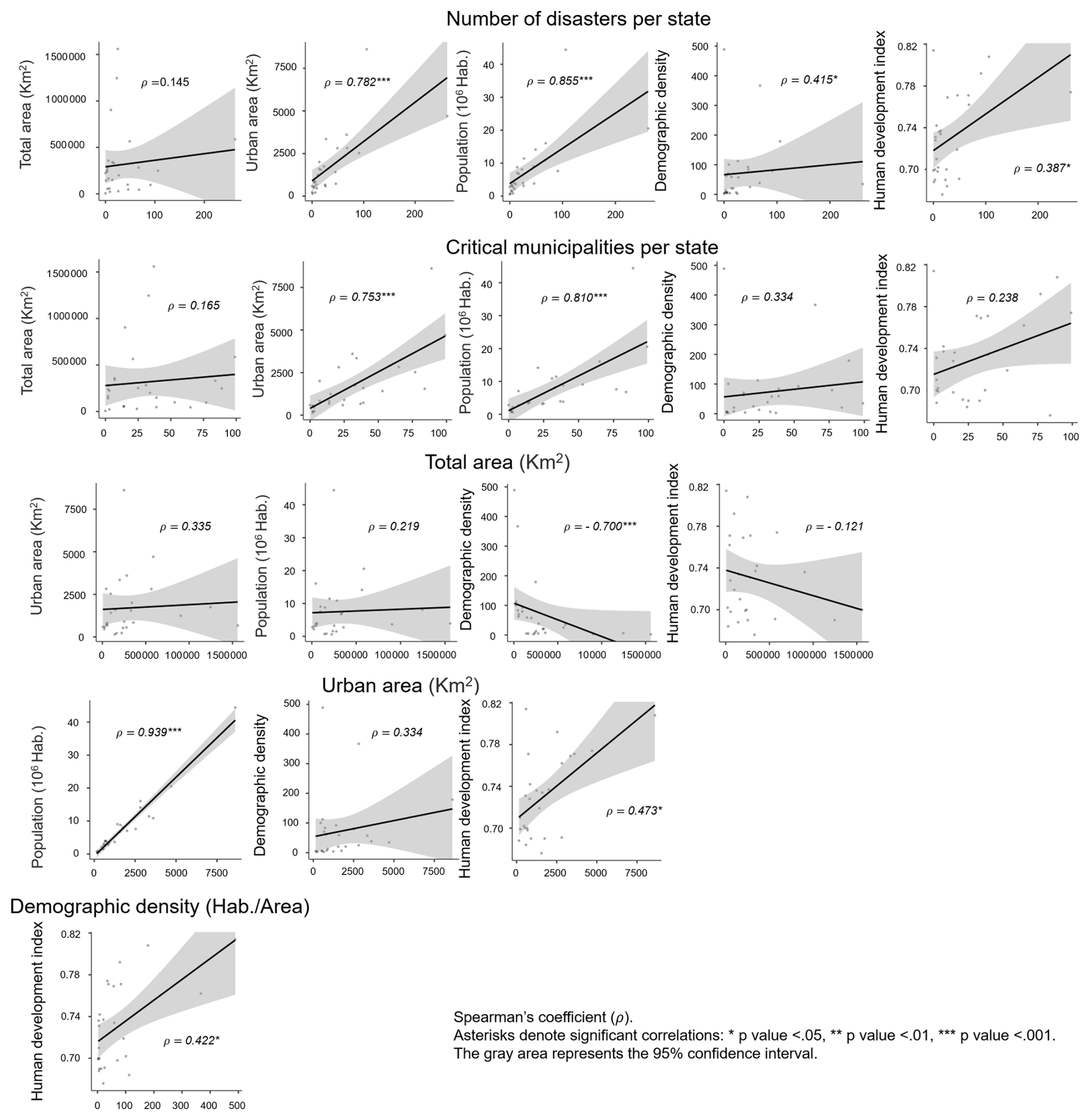
Figure 1Correlation analysis between disasters and critical municipalities by state, considering geopolitical, demographic, and socio-economic variables, based on MDR (2012), IBGE (2021, 2022), and Brasil (2023).
Our analysis revealed significant correlations that aid in understanding disaster risk (Fig. 1). For example, a robust positive correlation exists between population and the occurrence of disasters (ρ=0.855), suggesting that higher population densities are associated with a greater frequency of disasters. Similarly, urban area size shows a strong positive correlation with both the number of disasters (ρ=0.782) and critical municipalities (ρ=0.753), indicating that larger urban areas are more susceptible to disasters, likely owing to increased population density, infrastructure complexity, and economic activities.
Additionally, demographic density exhibits a moderate positive correlation with disasters (ρ=0.415), underscoring the role of population concentration in disaster occurrence. Interestingly, the HDI moderately correlates with disaster incidence (ρ=0.387), and this correlation may reflect the dual role of socio-economic development in enhancing disaster reporting and response capabilities while increasing the number of assets at risk.
4.1.1 Risk assessment before 2010
Following a series of significant SRD events in the states of Rio de Janeiro (1966, 1967, 1988, 1996) and São Paulo (1967), as documented by De Ploey and Cruz (1979), Schuster et al. (2002), Vieira and Fernandes (2004), and Avelar et al. (2013), a variety of regional methodologies gained prominence in the 1990s (Pimentel et al., 2020). By the mid-2000s, Brazil began developing systematic strategies for managing its impacts (Giustina, 2019). The government opted for a national-level unified risk assessment approach. In 2003, the first nationwide survey was started, and the PMRR was designed (Brasil, 2006) to promote strategic planning instruments to assess risks and propose structural solutions for mitigation (Sect. 2, Table 1).
Table 1Summary of the key findings of the Brazilian surveys for disaster prevention.
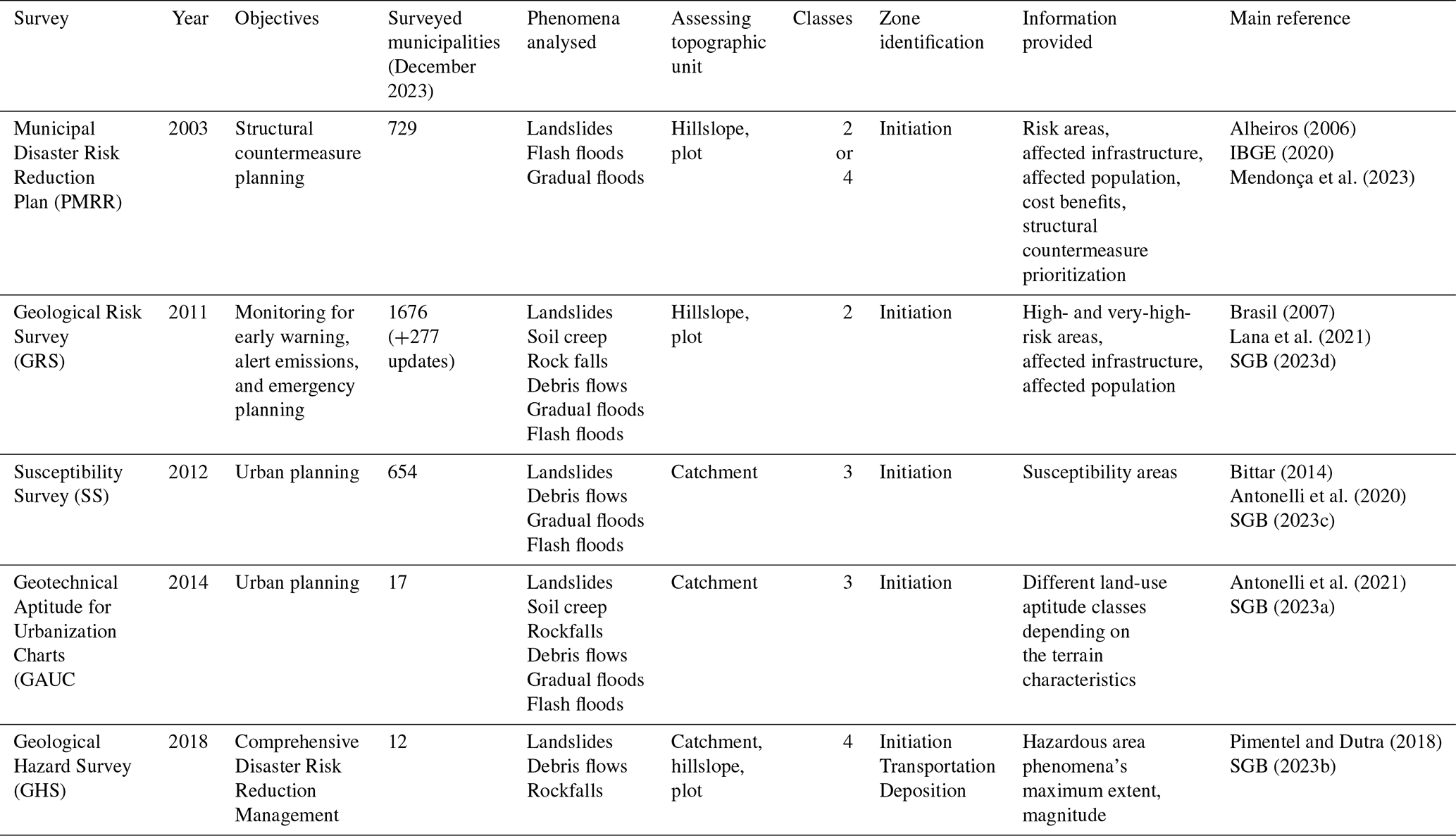
4.1.2 Mega-disaster of the mountainous region of Rio de Janeiro in 2011
In January 2011, Brazil experienced the most catastrophic disaster in its recorded history, namely the mega-disaster of the mountainous region of Rio de Janeiro (Dourado et al., 2012). This calamity was induced by torrential rainfall (241.8 mm / 24 h; peak intensity of 61.8 mm / 1 h). The total rainfall recorded between 1 and 12 January was 573.6 mm (Netto et al., 2013). The impact was a series of destructive debris flows, mudflows, and a substantial number of landslides (approximately 3600) (Fonseca and Cataldi, 2021). The official records indicate 947 fatalities, more than 400 missing people, and over 50 000 left homeless (Dourado et al., 2012). The financial cost was approximately USD 2.5 billion (World Bank Group, 2012).
After this event, the government promptly implemented measures to address sediment disasters. In the same year, Brazil established the National Plan for Risk Management and Response to Natural Disasters (MDR, 2012). Additionally, the government endorsed Law No. 12 608/2012 (Brasil, 2012), establishing the National Policy of Protection and Civil Defense, National System of Protection and Civil Defense, National Council of Protection and Civil Defense, National Plan for Risk Management and Response to Natural Disasters (NPRMRND), and National Center for Monitoring and Alerts of Natural Disasters. This law constitutes Brazil's most comprehensive legislative instrument for disaster risk reduction, integrating multiple policy mechanisms to mitigate the impacts of socio-economic disasters. As part of the NPRMRND, the GRS survey was launched in 2011, targeting 821 critical municipalities (Sect. 2, Table 1) (SGB, 2023d).
4.1.3 Last decade
Another NPRMRND component was the launch of two additional surveys focusing on urban planning. These surveys aimed to develop a progressive assessment framework and enhance preventive strategies, mainly providing strategic information for the municipality's decision-makers to optimize land-use management. Thus, the SS was developed in 2012, followed by the launch of the GAUC in 2014 (Table 1; SGB, 2023a, c). Between 2013 and 2017, the governments of Brazil and Japan engaged in a bilateral cooperation initiative known as the GIDES Project, which ultimately led to the development of GHS in 2018 (Sect. 2, Table 1) (Pimentel et al., 2020).
4.1.4 Correlation analysis of surveys with geopolitical and socio-economic variables
Figure 2 shows a strong-to-moderate correlation between these surveys and geopolitical, demographic, and socio-economic variables. GAUC and GHS were excluded from this figure due to the small number of municipalities implemented (17 and 12, respectively). The surveys showed strong positive correlations with the occurrence of disasters (PMRR, ρ = 0.896; GRS, ρ = 0.686; SS, ρ = 0.759) and critical municipalities (PMRR, ρ = 0.792; GRS, ρ = 0.749; SS, ρ = 0.691), indicating that these surveys effectively target municipalities with higher disaster incidences and heightened vulnerability. Population size (PMRR, ρ = 0.872; GRS, ρ = 0.646; SS, ρ = 0.624) and urban area size (PMRR, ρ = 0.841; GRS, ρ = 0.582; SS, ρ = 0.613) also play significant roles, suggesting the prioritization of larger, more densely populated urban areas.
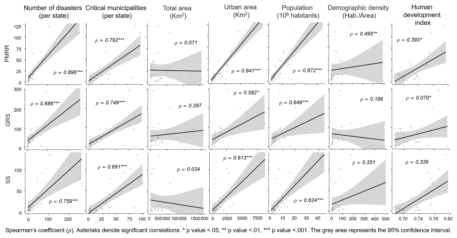
Figure 2Correlation analysis of geopolitical, demographic, and socio-economic variables with DRR assessment surveys. Analysis based on IBGE (2020) and SGB (2023c, d).
4.2 Risk assessment methodologies
4.2.1 General description
The Geological Survey of Brazil conducts GRS, SS, GAUC, and GHS surveys, employing standardized and unified methods throughout the entire national territory (Pozzobon et al., 2018). Although PMRRs adhere to federal basic guidelines, the method varies considerably depending on local specifics and survey entities (Mendonça et al., 2023).
All methods employ heuristic-based analyses to identify hillslopes and catchments where landslides and debris flows are likely to occur and qualify as prone areas (Table 2). GRS is purely qualitative and relies only on expert judgement to distinguish between high and very high classes (Lana et al., 2021). The other surveys provide probabilistic evaluations through empirical approaches. For instance, SS uses the relief unit's landslide density index. This approach helps to distinguish and categorize areas into high or moderate classes based on their landslide density (Antonelli et al., 2020). GAUC prioritizes moderate-to-low susceptibility areas for evaluation, deliberately excluding areas classified as highly susceptible. Environmental protected areas are also omitted. The characterization of geotechnical units is defined by a combination of the underlying lithological substrate and the overlying unconsolidated covering data (SGB, 2023a). GHS applies an empirical approach based on statistical analyses of the damage caused by past events (SGB, 2023b). Furthermore, none of these methods relies on deterministic analyses.
Table 2Comparative analysis of survey methods in Brazil. Analysis based on Alheiros (2006), Lana et al. (2021), Antonelli et al. (2020, 2021), and Pimentel and Dutra (2018).
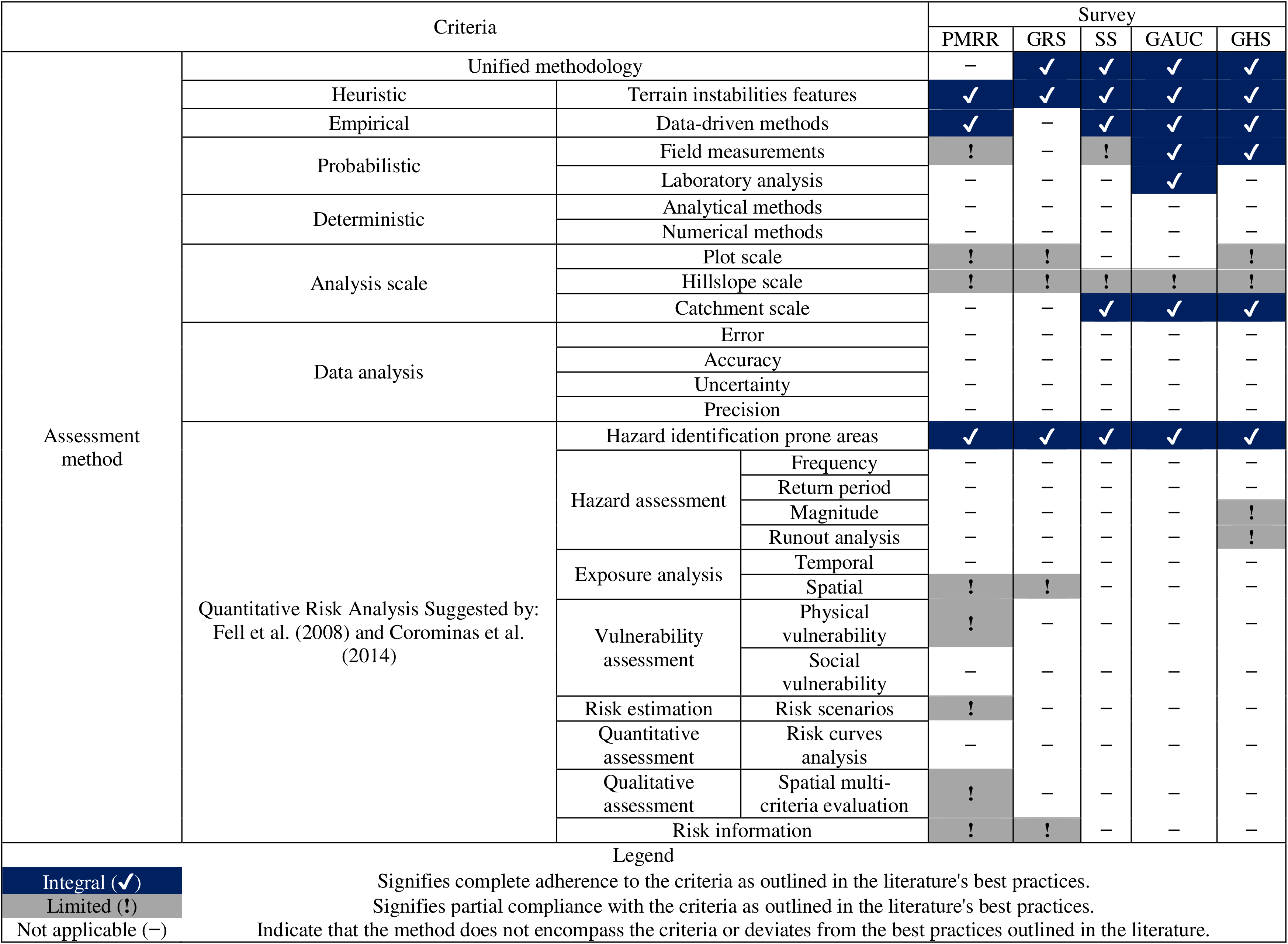
The GRS method integrates a heuristic approach for exposure analysis and risk area delimitation (Lana et al., 2021). On the contrary, Mendonça et al. (2023) noted that only a limited number of PMRRs partially fulfilled the criteria for exposure analysis, physical vulnerability assessment, risk estimation, multi-criteria spatial evaluation, and risk information. For example, despite being advocated in the guidelines, social participation does not occur effectively. The authors emphasized that only 6 % of PMRRs adopted multi-criteria analyses. Merely 4 % considered cost–benefit ratios as a prioritization criterion for structural measures. Usually, prioritization focuses on risk classes and the number of households at risk.
The topographic units used to assess risk vary depending on the purpose of each survey. The SS, GAUC, and GHS surveys conduct catchment (>10 ha) analyses (Table 1, Fig. 3). In some instances, GHS also conducts plot-scale (1–100 m2) analyses. On the other hand, PMRR and GRS employ partial plot (100–500 m2) and hillslope (>500 m2–10 ha) examinations. None of these surveys assesses the correlation between landslide incidents and rainfall patterns. Data analysis was conspicuously absent in all the surveys (Table 2). In addition, all the surveys considered hazard-prone areas. Notably, none of the surveys consider hazard assessment criteria such as frequency and return period, except for GHS, which incorporates limited analysis of magnitude and runout distance (Pimentel and Dutra, 2018).
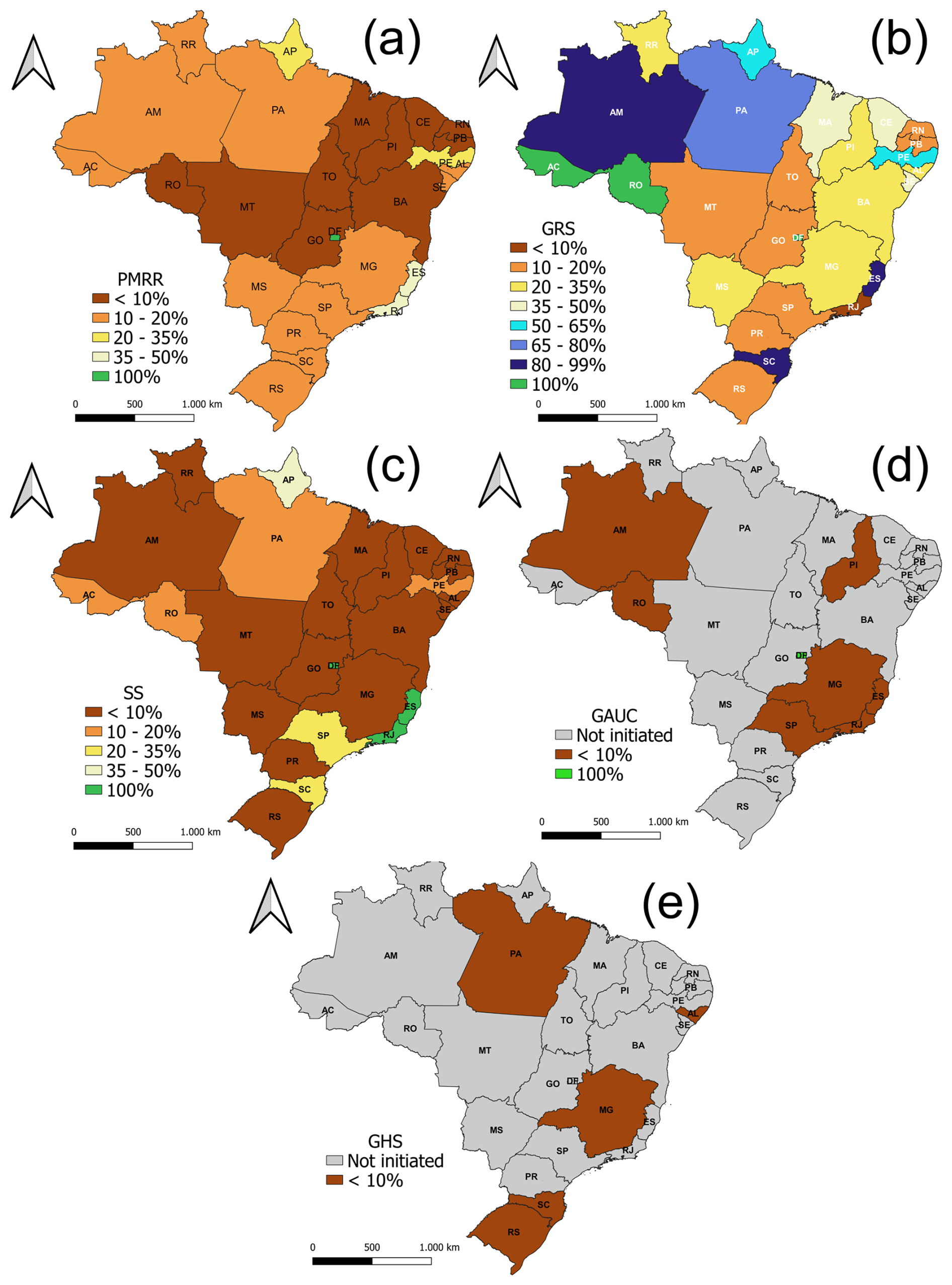
Figure 3Coverage of state-level DRR surveys. Analysis based on IBGE (2020) and SGB (2023a–d). The current status refers to December 2023.
4.2.2 Input data and data collection
The surveys mainly relied on the inventory of past disasters and topographic input data (Table 3). For instance, all surveys considered the role of slope gradients (e.g. usually ≥25° for shallow landslides) (e.g. Pimentel and Dutra, 2018). Other topographical parameters are not included, except for GHS, which considers the roles of elevation, slope length, shape, and direction (e.g. slope height ≥5 m for landslide-prone areas). Usually, landslide inventory and topographic parameter data are collected through field inspection or aerial orthophotos and satellite imagery interpretations (SGB, 2023d). Recently, an emerging trend has involved the adoption of drones and uncrewed aerial vehicles to acquire high-resolution imagery and updated topographic data (SGB, 2023c).
Table 3Comparative analysis of the input data per survey in Brazil. Analysis based on Alheiros (2006), Lana et al. (2021), Antonelli et al. (2020, 2021), and Pimentel and Dutra (2018).
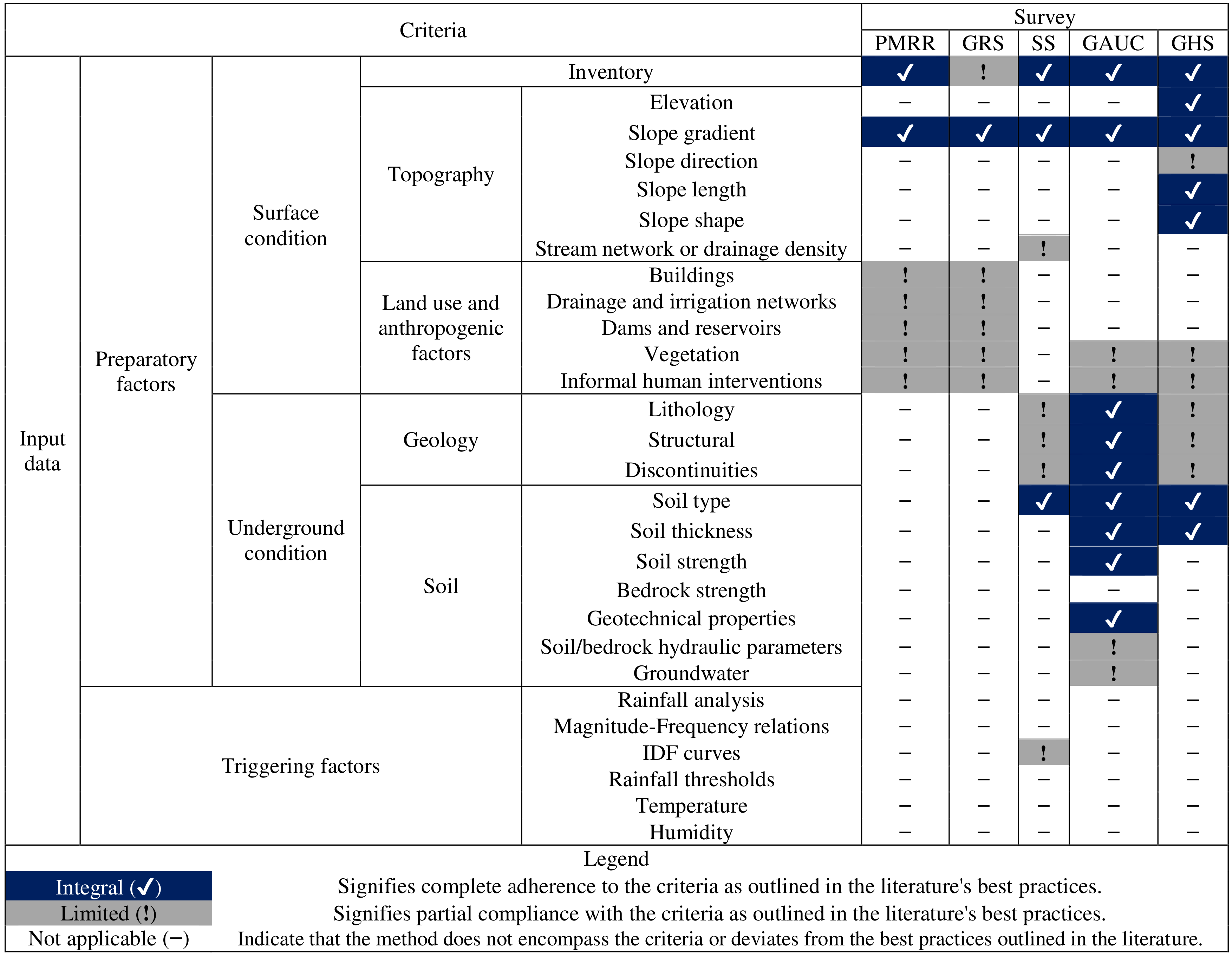
Various additional data are used for each risk assessment. PMRR and GRS heuristically incorporate land-use and human-impact variables, such as irrigation and drainage networks, cut-fill, and dams (Table 3). These surveys use census data, such as population and building material type (i.e. masonry and wood), to correct data about land use and human impacts (Mendonça et al., 2023; SGB, 2023d). The SS, GAUC, and GHS surveys partially incorporated controls related to subsurface factors, such as geological data and soil characteristics (Table 3). To assess disaster risk, these surveys used spatial correlations between phenomena, i.e. landslides, debris flow occurrences, lithology, and soil types (Pimentel et al., 2020). SS establishes a correlation between the occurrence of geological discontinuities, such as faults or fractures (discontinuity density index) and the frequency of landslides in a given area. This approach enables a more accurate categorization (Antonelli et al., 2020). GAUC evaluates soil properties using a combination of field and laboratory measurements (SGB, 2023a). Field tests involve a tactile–visual examination and a determination of the soil's bearing capacity under vertical loading. The laboratory tests conducted include consistency limit (or Atterberg limit) tests to determine the soil's liquid, plastic, and shrinkage limits, as well as particle size distribution (granulometry) tests (Antonelli et al., 2021). In contrast, GHS utilizes measurements of soil thickness to define the maximum extent of potential phenomena (Pimentel and Dutra, 2018). However, none of these surveys considered triggering factors, such as rainfall, precipitation, or thresholds, for assessing critical areas.
4.2.3 Outcomes and output data
The information provided depends on the objective of the investigation. Furthermore, except for the PMRR, all other survey results are readily accessible online (SGB, 2023a–d). Generally, these datasets encompass technical reports (except for SS), thematic charts, and GIS data. Most surveys classify sensitive areas into two to four levels, except for GAUC, wherein the number of classes varies depending on the municipality's complexity (Table 1).
All these surveys provide data concerning sediment-related phenomena, including landslides, debris flow, and rockfall (Table 4). All surveys also identified the potential initiation zone. GHS also provided a potential area for sediment transport and deposition. The first two surveys, PMRR and GRS, aim to support structural and non-structural countermeasures planning (Table 1), providing information about the impact on infrastructure and affected populations. Specifically, PMRR offers an inventory of SC tailored to mitigate risks and cost–benefit estimations.
Table 4Comparative analysis of the output data per survey in Brazil. Analysis based on Alheiros (2006), Lana et al. (2021), Antonelli et al. (2020, 2021), and Pimentel and Dutra (2018).
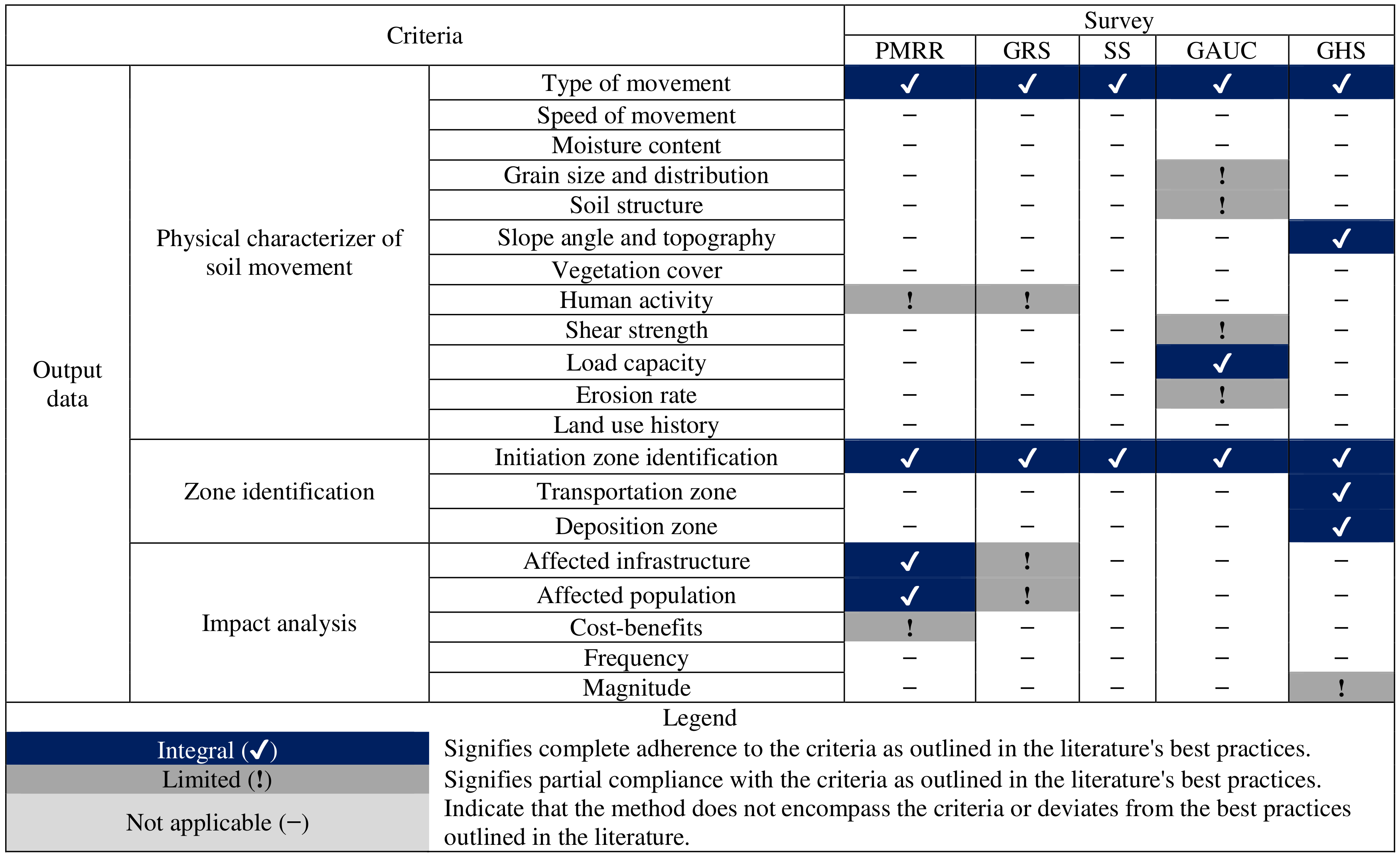
Moreover, SS provides a legend with detailed descriptions and illustrative representations of distinct classes explicitly tailored to urban planning. The GAUC survey categorizes terrain into three primary aptitude classes (high, moderate, and low), which are subdivided into specific geotechnical units, offering detailed insights and recommendations for each unit's land-use planning. It also presents supplementary maps and strongly emphasizes information related to aptitude classes and soil characteristics. GHS focuses on topographic data, providing hazardous-prone areas, delineating potential maximum extents, and distinguishing them into critical and dispersion areas (Table 4).
In addition, Rocha et al. (2021) evaluated the effectiveness of the SS, GHS, and GAUC methods in the municipality of Nova Friburgo by assessing landslides triggered during the 2011 mega-event in the mountainous region of Rio de Janeiro. The study found that the GHS method outperformed the others, achieving a 95 % match between mapped hazard zones and areas destroyed by the disaster, indicating strong performance in identifying true positives. However, the authors also reported that 47 % of areas were classified as hazardous by GHS, suggesting that there were also many slopes that were deemed dangerous but did not collapse. In contrast, the SS and GAUC methods yielded an accuracy of 55 % and were considerably less effective in detecting the affected areas.
5.1 Implemented status of surveys
These surveys are still in progress in 2024 and have not yet achieved nationwide coverage. Based on information from IBGE (2020), the PMRR was carried out in 729 municipalities (Fig. 3a). However, a comprehensive national repository for these data is currently unavailable. Espírito Santo and Rio de Janeiro are the only states with around 40 % of their municipalities surveyed. In Amapá and Pernambuco, surveying has been done for approximately one-quarter of their municipalities. The remaining states have less than 20 % of their municipalities surveyed.
The GRS method was conducted in 1676 municipalities, with 277 subsequent updates implemented (Table 1, Fig. 3b). According to the SGB (2023d), Acre, Rondônia, and Distrito Federal have been thoroughly surveyed. Amazonas, Santa Catarina, and Espírito Santo covered over 90 % of the state. Several states have achieved significant progress, covering over 50 % of their territory, notably in Amapá, Pará, Pernambuco, and Roraima. In contrast, other states are still in the initial phases of surveying, with less than 20 % coverage, including Goiás, Minas Gerais, Paraíba, Paraná, Piauí, Rio de Janeiro, Rio Grande do Norte, Rio Grande do Sul, São Paulo, Sergipe, and Tocantins. Notably, the Department of Mineral Resources of the state of Rio de Janeiro (DRM-RJ) surveyed 87 % of the state using a different methodology for assessing imminent geological risk, which was not evaluated in this study (DRM, 2023).
The number of municipalities surveyed for SS is relatively similar to PMRR. According to the SGB (2023c), the surveying processes in Distrito Federal, Espírito Santo, and Rio de Janeiro have been completed, followed by Amapá (43 %), Santa Catarina (34 %), and São Paulo (20 %), which are at more advanced stages of survey completion (Fig. 3c). Conversely, the remaining states demonstrate less than 20 % coverage. Furthermore, more recent surveys, such as GAUC and GHS, have assessed only 17 and 12 municipalities, respectively (SGB, 2023a, b). GAUC's efforts are primarily concentrated in Rio de Janeiro state, achieving 5 % of coverage (Fig. 3d). In contrast, GHS is focused on Santa Catarina, with 2 % coverage (Fig. 3e).
5.2 Examining the correlation between risk assessment surveys and the implementation of disaster reduction countermeasures
Risk assessment surveys are vital resources for various risk management initiatives. Therefore, the effectiveness of these surveys can be evaluated by examining the activities and initiatives developed from the basic information provided by them. Figure 4 illustrates the distribution of municipalities across the Brazilian states that have adopted various DRR initiatives, such as master plans (MPs), landslide-specific laws (SLs), land use and land occupation laws (LULOLs), early warning systems (EWSs), emergency response plans (ERPs), and structural countermeasures (SCs). The regional distribution of DRR initiatives across Brazilian states reveals notable contrasts in implementation levels. First, the Federal District was excluded because it contains only one municipality, which could distort the overall analysis. The results showed that among Brazil's 5570 municipalities, only about 15 % on average have implemented MPs. This low implementation rate is consistent across most states. The south-eastern and southern regions demonstrate higher implementation levels (Fig. 4), while the northern and mid-western regions show considerably lower levels. Rio de Janeiro (33 %), Espírito Santo (27 %), and Santa Catarina (23 %) lead in MP implementation, whereas states such as Tocantins (4 %), Rondônia, Amazonas, Amapá, Piauí, and Paraíba (6 %) fall below the national average. The implementation of landslide-specific laws (LSLs) remains notably low across all states. Only Rio de Janeiro and Pará exceed the 5 % threshold, standing out as the exceptions in this category. In the northern region, most states exhibit a relatively low adoption of DRR measures (Fig. 4). However, Amazonas, Pará, and Amapá present higher percentages in specific indicators in this region. Amazonas, for instance, shows considerable efforts in implementing ERPs (23 %) and EWSs (11 %). Pará demonstrates moderate values across all initiatives, particularly in MPs (13 %) and LULOLs (12 %). Amapá also stands out, with 31 % of municipalities having ERPs and 19 % implementing LULOLs. In contrast, Roraima and Tocantins register the lowest levels in the region, with most indicators below 5 % and a complete absence of EWSs, emergency plans, and SCs in Roraima. In the north-eastern region, the implementation pattern is more heterogeneous (Fig. 4). States such as Pernambuco and Alagoas lead in most indicators. Pernambuco exhibits significant adoption of MPs (20 %), ERPs (25 %), and SCs (11 %), while Alagoas shows high percentages in EWSs (14 %) and ERPs (18 %). Other states, such as Ceará and Bahia, demonstrate moderate values across all initiatives. In contrast, Piauí and Paraíba appear among the least engaged in the region, with consistently low percentages for specific plans, EWSs, and SCs. In the mid-western region, results vary significantly (Fig. 4). The Federal District represents a clear outlier, reporting 100 % implementation for all DRR categories except for SCs. Mato Grosso do Sul follows with a comparatively high adoption of master plans (13 %), LULOLs (14 %), and EWSs (8 %). Meanwhile, Mato Grosso and Goiás exhibit limited implementation, with most indicators – particularly EWSs, ERPs, and SCs – remaining below 5 %.
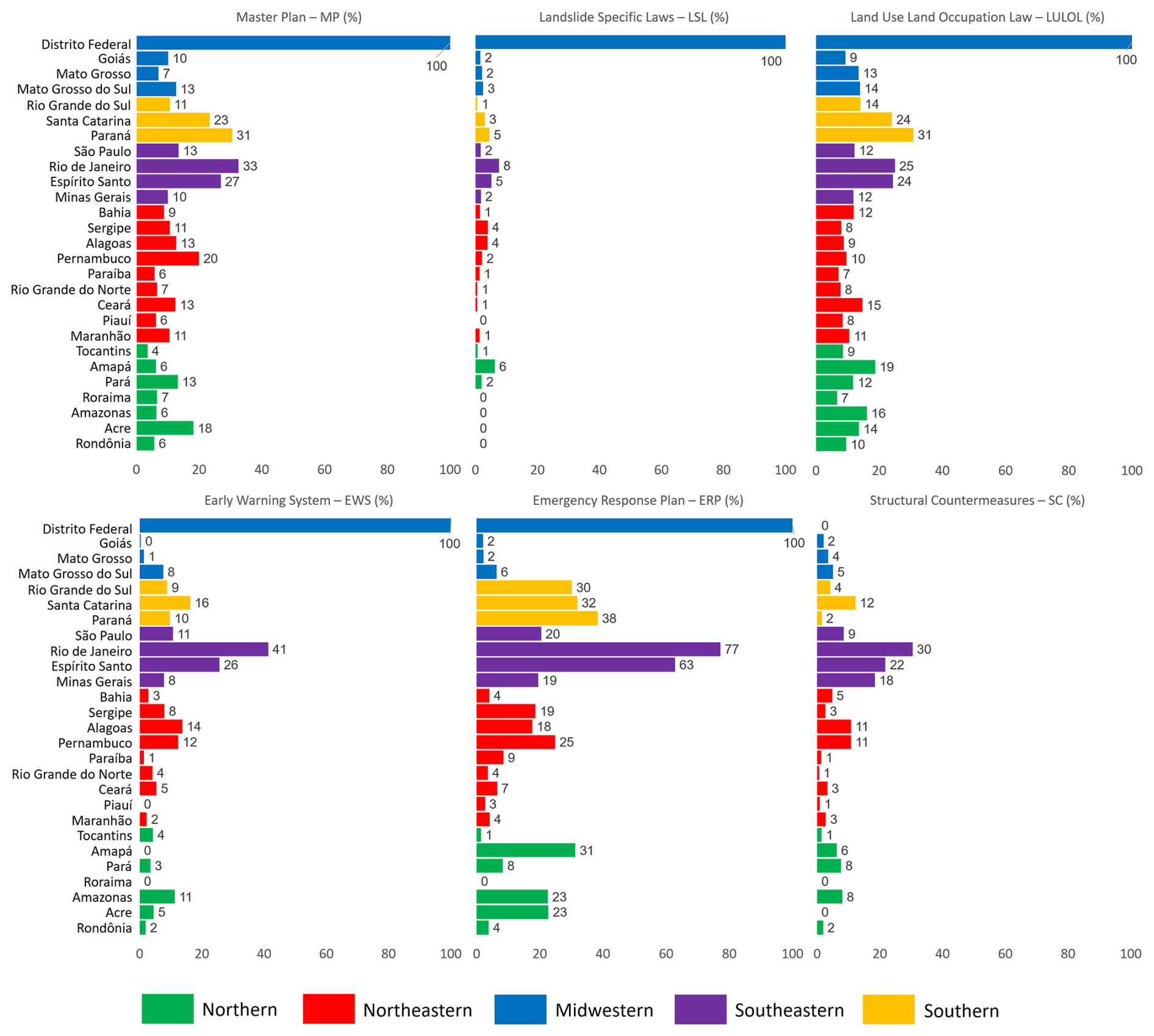
Figure 4Percentage of municipalities implementing sediment-related DRR initiatives in each Brazilian state. Values represent the proportion of municipalities (%) per state. Data source: IBGE (2020) DRR dataset. Bars are colour coded by Brazil's five macro-regions.
The south-eastern region stands out as the most advanced in DRR implementation (Fig. 4). Rio de Janeiro and Espírito Santo lead the country, with exceptionally high percentages across nearly all indicators. Rio de Janeiro, for example, reports 77 % of municipalities with ERPs, 41 % with EWSs, and 30 % with SCs. Espírito Santo shows similar results, including 63 % with ERPs and 26 % with EWSs. São Paulo and Minas Gerais also demonstrate widespread adoption, with São Paulo exceeding 10 % in all indicators and Minas Gerais registering 20 % for ERPs and 18 % for SCs. In the southern region, DRR measures are generally well adopted (Fig. 4). Paraná shows the highest percentages for MPs (31 %) and LULOLs (31 %) among all states in the region. Santa Catarina also performs well, particularly in EWSs (16 %) and ERPs (32 %). Rio Grande do Sul, while displaying lower values compared to its southern counterparts, still achieves notable implementation for ERPs (30 %). Overall, the south-eastern and southern regions exhibit the highest concentration of municipalities with DRR measures, while the northern and mid-western regions – excluding the Federal District – tend to lag behind, with considerable disparities within and between regions.
The effectiveness of these surveys was evaluated using Spearman's rank correlation coefficient to assess the association between adopting specific DRR strategies across 5570 municipalities and the outcomes from the corresponding risk assessment surveys. As shown in Fig. 5, the analysis considers absolute counts of municipalities per state for risk assessment surveys and DRR initiatives, providing a robust measure of their association. Because GAUC and GHS have low implementation levels, they were removed from this analysis.
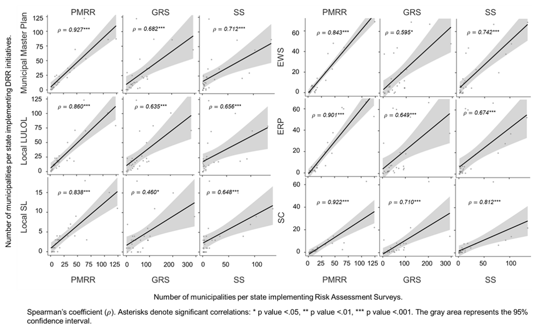
Figure 5Spearman's rank correlation between the number of municipalities per state implementing risk assessment surveys (PMRR, GRS, SS) and the number of municipalities per state adopting specific DRR strategies (municipal master plan, local LULOL, local SL, EWS, ERP, SC). The analysis includes 5570 Brazilian municipalities based on IBGE (2020) and SGB (2023c, d).
The PMRR survey showed a remarkably strong correlation with most DRR initiatives, indicating a robust interconnection between comprehensive DRR strategies and PMRR. The strongest correlation was observed with MP (ρ = 0.927, p < 0.001), SC (ρ = 0.922, p < 0.001), ERP (ρ = 0.901, p < 0.001), and EWS (ρ = 0.843, p < 0.001). In addition, GRS shows a significant correlation with SC (ρ = 0.710, p < 0.001), ERP (ρ = 0.649, p < 0.001), MP (ρ = 0.642, p <0.001), and LULOL (ρ = 0.635, p < 0.001) and shows moderate for other initiatives. Further, SS also shows a strong correlation with SC (ρ = 0.812, p < 0.001), ERP (ρ = 0.674, p < 0.001), and EWS (ρ = 0.742, p < 0.001). It has a moderately high correlation with other initiatives.
The positive correlation between surveys and DRR strategies indicates that adopting risk assessment surveys enhances municipalities' implementation of comprehensive DRR strategies. The McDonald's omega (ω) analysis, yielding a value of 0.964, was conducted to ensure the reliability of the results. It demonstrated excellent internal consistency, thereby supporting the validity of our Spearman's correlation findings and ensuring the robustness and credibility of the collected data.
5.3 Applicability for disaster reduction initiatives
To complement the operational analysis presented in Sect. 5.2, a relevance matrix (Fig. 6) was developed to explore the applicability of federal risk assessment surveys across multiple dimensions of disaster risk reduction. While the previous section focused on the implementation status of key DRR initiatives based on official indicators from the municipal profiles (IBGE, 2020), the matrix presented here evaluates the suitability of these DRR initiatives derived from internationally recognized methodological frameworks (Hungr et al., 2005; Fell et al., 2008; Corominas et al., 2014). The matrix displays the degree to which each survey supports different DRR elements, using a gradient scale from dark-blue (0 – not applicable) to dark-red (4 – fully applicable). This classification reflects the functional alignment of each survey with best practices for its respective scale, taking into account its defined scope and the extent to which it is integrated into formal governance practices. The resulting overview highlights distinct differences in applicability among the methodologies.
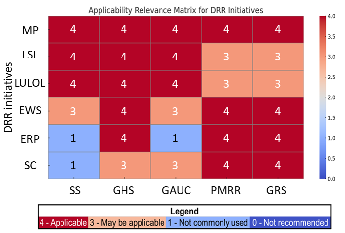
Figure 6Brazilian DRR assessment relevance matrix based on applicability recommendations from Hungr et al. (2005), Fell et al. (2008), and Corominas et al. (2014).
The matrix reveals a clear differentiation in the breadth and depth of applicability among the five federal risk assessment methodologies. PMRR and GRS exhibit consistently high applicability across a range of DRR initiatives, particularly in emergency response plans (ERPs), early warning systems (EWSs), and structural countermeasures (SCs). Their operational versatility enables integration into a broad set of initiatives; however, their role in shaping legislative frameworks – particularly LSL and LULOL – remains limited. In contrast, GAUC demonstrates strong alignment with legal instruments, although its contribution to ERP appears comparatively constrained. SS similarly supports the legislative dimension, but its applicability is markedly lower in ERP and SC. Finally, GHS stands out as the most applicable methodology, achieving either full (score of 4) or substantial (score of 3) relevance across all DRR categories. Its balanced integration emphasizes its utility as a comprehensive tool for multi-level risk governance.
5.4 Cost per beneficiary analysis
Table 5 provides an overview of Brazilian surveys implemented in a medium-sized municipality, with notable variations in cost–beneficiary ratios. The PMRR survey exhibits a high cost per beneficiary of USD 6.66, indicating inefficiencies that may benefit from an updated review. The initial phase, involving mapping risk areas, requires at least 8 months to complete (IPPLAN, 2016). Despite the lack of public data availability for subsequent phases, the study was reported to exceed 1 year. According to Mendonça et al. (2023), the duration and costs vary by municipality, indicating a flexible approach that accounts for territorial extent and inherent complexity. Conversely, the GRS method ranked second in the evaluation, demonstrating a strong balance between efficiency and cost-effectiveness. Notably, GRS is faster and less resource intensive than the PMRR method, achieving a cost per beneficiary of USD 1.309. This result highlights the practical applicability and economic advantages of this approach in disaster risk reduction efforts.
Table 5Cost per beneficiary's attributes of Brazilian DRR surveys.
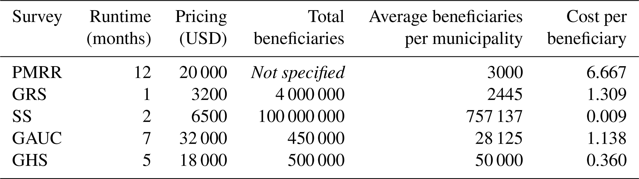
The SS method achieved the highest position, securing the maximum average number of beneficiaries per municipality owing to its low average runtime and pricing, as detailed in Table 5. In addition, this survey stood out with an exceptionally low cost of USD 0.0009 per beneficiary, demonstrating highly effective resource use. Meanwhile, the GAUC and GHS surveys showed mixed results. GAUC showed higher costs, longer execution durations, and a cost–beneficiary ratio of 0.1429. Notably, despite being established 4 years before GHS (Table 1), GAUC shows a smaller average number of beneficiaries. GHS features a reasonable average implementation time and costs, indicated by a reasonable cost of USD 0.36 per beneficiary, holding the third position.
Based on the results, we structured the discussion into three key questions. (1) Are any elements lacking in the current landslide risk assessments? Referencing Sect. 4, we debate these techniques and their feasibility, identifying deficiencies and indicating potential enhancements based on global best practices. (2) What is the reason for the low implementation rate of risk assessments? Drawing from insights in Sects. 4 and 5 and literature references, we discuss the existing DRR framework and examine the potential reasons behind Brazil's low implementation rate of these assessments. (3) Does risk assessment effectively contribute to initiatives related to sediment disaster prevention? Based on the findings in Sects. 4 and 5, we explore the effectiveness of risk assessment surveys in contributing to sediment disaster prevention initiatives.
6.1 Are there any elements lacking in the current sediment-related risk assessment surveys?
6.1.1 Specific deficiencies and recommendations
Current risk assessment methodologies in Brazil exhibit substantial limitations, redundant efforts, and significant challenges (Tables 2–4). This underscores the urgent need for methodological improvements and the adoption of more comprehensive quantitative approaches. The SS and GRS methods are well established and cover many surveyed municipalities. Nevertheless, they are subject to several limitations. Thorough updates and refinements may face significant implementation challenges. Despite the impressive national coverage of PMRR, an update accompanied by thorough and unified procedural guidelines is clearly needed, as demonstrated by Mendonça et al. (2023). Given the restricted coverage, the GAUC and GHS surveys were considered the most suitable for methodological improvements. Recognizing the complementary nature of the five surveys, we propose a nuanced, systematic, and progressive multi-level approach to risk assessment that aligns with global best practices and considers local specifics (e.g. Fell et al., 2008; Corominas et al., 2014).
Absence of data collection and updates
Disaster database and data analysis
Effective DRR management relies heavily on high-quality and consistent data. Guzzetti et al. (2012) emphasized the need for practical working definitions and optimal inventory databases, while Guzzetti et al. (1999) highlighted the importance of uniform terminology for consistent technical databases. Fell et al. (2008) also noted that the efficacy of DRR management is deeply linked to data quality. Despite significant investments, Brazil still lacks unified and standardized disaster databases and inventories, leading to significant challenges in subsequent efforts. Therefore, as recommended by Froude and Petley (2018), UNDRR (2020), and Corominas et al. (2023), Brazil needs to adopt standardized terminology for sediment-related phenomena and establish a unified national technical database. Guzzetti et al. (2006) also confirmed no consensus on validating the surveys. The current data analysis processes of Brazilian assessments are solely based on heuristic subjective field inspections (Dias et al., 2021). Therefore, incorporating an analysis of the models' accuracy based on inventories of past events, as suggested by Fell et al. (2008), is highly recommended.
Demographic data
The PMRR and GRS methods estimate potentially affected populations and damaged areas (Tables 2 and 4) based on 2010 census data (Mendonça et al., 2023). However, rapid urban sprawling leads to underestimations due to outdated information (Silva-Rosa et al., 2015). Consequently, these assessments may not accurately reflect current risk stages but represent conditions from almost 15 years ago. However, recognizing communal efforts that assess and monitor the occupation and migration patterns of Brazil's population is essential. To address this challenge, a semi-quantitative approach is recommended for accurate and consistent analysis. Souza et al. (2019) combined 2010 census data with GRS survey outcomes to develop BATER (the Statistical Territorial Risk Base), providing insightful data on at-risk population exposure. Alternatively, Emberson et al. (2020) adjusted the world-gridded population dataset with the local population density index to estimate population exposure and used OpenStreetMap to evaluate infrastructure exposure. Integrating these procedures with the 2022 demographic census data (IBGE, 2022) would enhance accuracy and provide updated population exposure estimates, particularly in the GRS survey.
Site-condition data
These surveys rely heavily on topographic parameters (e.g. Reichenbach et al., 2018; Dias et al., 2021) and underground conditions (Table 3). Nevertheless, most data utilized as input typically date back at least 5 years ago, making it challenging to properly evaluate terrain modifications due to human activities. A coherent approach includes continuously updating topographic data to ensure these assessments remain relevant and accurate. Due to similar challenges faced with demographic data, regular updating at the national level is complex to implement. To overcome this issue, establishing a shared database with relevant stakeholders is advisable for a more precise evaluation. For instance, Junichi and Naoki (2020) mentioned the public–private consortium as a systematic approach to leveraging advanced technologies and expertise in Japan.
The GAUC survey's accuracy in assessing soil characteristics can be enhanced by integrating global best practices in geotechnical testing and statistical analysis. Enhancements such as standard and cone penetration tests (Uchida et al., 2009), geophysical techniques (Bortolozo et al., 2019), rock quality designation analysis (Zheng et al., 2018), and building information modelling (Khan et al., 2021) provide detailed subsurface analysis and a better understanding of soil and bedrock properties. Infiltration modelling improves knowledge of water dynamics (Failache and Zuquette, 2018), and statistical methods like fuzzy clustering reduce subjectivity in geotechnical classifications (Hossein Morshedy et al., 2019).
Lack of output data
Frequency and magnitude
Evaluations of frequency and magnitude are crucial for creating accurate quantitative risk assessments and informing decision-making processes (Corominas and Moya, 2008), particularly in regions like Brazil, where the absence of temporal context restricts the predictive accuracy of the likelihood of events – a gap that becomes increasingly problematic in the climate change context (Marengo et al., 2021). Incorporating frequency analyses and enhancing magnitude assessments are crucial for improving the GHS survey and advancing the overall effectiveness of quantitative risk assessment and prediction across the other surveys (Table 2). Temporal and spatial analyses can be performed using a variety of statistical techniques (e.g. Guzzetti et al., 1999, 2005; Guthrie and Evans, 2004; Ayalew and Yamagishi, 2005). Incorporating these elements into the SS survey would provide more detailed information for stakeholders (Segoni et al., 2018).
Runout area
The runout area evaluation allows a more precise prediction of sediment-related events' trajectory, extent, and impact (Rickenmann, 2005; Corominas et al., 2014). Grasping the potential reach and force of material movement allows planners and decision-makers to more effectively foresee an event's possible consequences and intensity, facilitating the development of customized strategies (Fell et al., 2008). Although all surveys assessed initiation-prone areas, only GHS provided a limited understanding of runout distances (Table 2). However, its reliance on national parameters limits applicability to local contexts, underscoring the need for improvement that reflects specific regional conditions (McDougall and Hungr, 2004; McDougall, 2017). Incorporating power-law equations and an empirical–probabilistic approach has been demonstrated to yield satisfactory outcomes, as evidenced by Corominas (1996), Rickenmann (1999), Guzzetti et al. (2002), Legros (2002), Kimura et al. (2014), Brideau et al. (2021), and Di Napoli et al. (2021).
Data on socio-economic impacts
Socio-economic indicators are essential for building resilience and providing a solid foundation for adaptive mitigation strategies (Fell et al., 2008). Historically, risk analysis in Brazil has primarily focused on physical vulnerabilities (Mendonça et al., 2023), as evidenced by Sect. 4.2.1. While disasters arise from the interplay between physical and societal factors (Veyret, 2007), extensive disaster research has consistently demonstrated that impacts vary significantly across different societal segments (e.g. Sutley and Hamideh, 2020). Addressing this issue requires integrating GRS and PMRR vulnerability societal indicators (Wisner, 2016). These criteria should include educational levels, risk perception, demographic details such as age and the needs of special groups, and economic conditions such as income levels and local economic disparities. These parameters enable the creation of detailed thematic risk maps and tailored strategies (Miguez et al., 2017; Sim et al., 2022). For instance, Fox et al. (2024) integrated socio-economic factors with traditional risk models to provide a more holistic vulnerability analysis. As a suggestion, the IBGE (2022) data contain numerous socio-economic features that can be used to refine the accuracy and effectiveness of vulnerability assessments.
6.2 What are the reasons for the low implementation rate of risk assessments?
Figure 2 confirms the strategic approach that aims to maximize the number of beneficiaries and mitigate extensive damage in areas with larger populations and more significant infrastructure. However, despite the strong correlations identified, the surveys exhibited low implementation rates (Fig. 3). Therefore, we analysed the potential challenges contributing to these low rates and gain insights into areas that warrant improvements to enhance national coverage.
6.2.1 Political issues
The results showed a strong positive correlation between disasters and urban areas (ρ = 0.782) as well as the population (ρ = 0.855), indicating a significant impact on urban populations (Fig. 1). The political landscape greatly influences the implementation of DRR strategies, especially in regions with unstable governance or chronic political instability (Veyret, 2007; Nogueira et al., 2014). Such instability often leads to a lack of sustained commitment to DRR policies, with political priorities shifting with leadership changes, resulting in inconsistent support and funding (Almeida, 2015). Resource allocation often competes with other political agendas, marginalizing DRR initiatives (Ganem, 2012). The results highlighted low adherence to master plan implementation, with approximately 15 % of Brazil's 5570 municipalities reporting implementation (Fig. 4). The strong correlation between legislative prevention mechanisms (MP, LULOL, SL) and surveys (Fig. 5) indicates a general trend towards implementing legal measures across municipalities, which may be partly influenced by higher implementation rates in disaster-affected areas. However, adoption rates for local land use and occupation (LULOL) and sediment disaster prevention (SL) laws are still low, at 14 % and 2 %, respectively, highlighting a lack of political commitment to disaster risk management. The low engagement and discontinuity in subsequent initiatives underscore the significant impact of political dynamics on the DRR cycle, consistent with Silva's (2022) findings. Another contributing factor is public managers' general lack of awareness or underestimation (Londe et al., 2015). Henrique and Batista (2020) suggested that many officials may not fully recognize the value of these surveys in preventing sediment-related disasters, leading to their lower priority. Challenges in implementing an PMRR arise from decentralizing government resources and varied execution by different entities, leading to inconsistent outcomes (Mendonça et al., 2023). Such decentralization requires active participation and financial investment from municipal administrators, thus limiting effective risk mitigation (Raposo, 2019).
6.2.2 Demographic issues
Brazil's demographic dynamics pose significant challenges to the effective implementation of DRR strategies. Correlating data from IBGE (2020, 2022) demonstrates a strong positive association between population size and the occurrence of disasters (ρ=0.855), indicating that areas with higher population densities, especially urban areas (ρ=0.782), are more prone to frequent disasters (Fig. 1). These observations align with global trends, reported by Maes et al. (2017), and Brazilian trends, highlighted by Alvalá et al. (2019). According to Ozturk et al. (2022), rapid urbanization further compounds these vulnerabilities, as more people live in hazard-prone areas lacking sufficient infrastructure, thereby complicating the implementation and effectiveness of DRR initiatives. Urban sprawl frequently causes disjointed and unplanned development, leading to significant gaps in the coverage and accuracy of risk assessment data (Bozzolan et al., 2023). Consequently, these data often become outdated or incomplete.
6.2.3 Socio-economic issues
The results demonstrated a weak positive correlation between the HDI and disaster incidence (ρ = 0.387) (Fig. 1). This correlation suggests a dual phenomenon: municipalities with higher socio-economic development have better disaster reporting, DRR infrastructure, and improved capabilities (Ozturk et al., 2022). Conversely, increased economic activities and asset accumulation elevate potential losses and recovery costs. Socio-economic disparities influence public and political engagement. Thus, municipalities with lower HDI may struggle with effective DRR strategies due to limited resources and infrastructure (Lin et al., 2023). Data show that municipalities with higher HDI scores tend to implement more PMRRs (Fig. 2; ρ = 0.393). As PMRR implementation is driven by direct municipal demand, regions with higher socio-economic development may likely adopt advanced disaster management solutions. This assumption corroborates findings from Londe et al. (2015), who emphasized that local capacities vary markedly depending on resource allocation and institutional support. The moderate positive correlation with SS (ρ = 0.339) may suggest that the Geological Survey of Brazil targets municipalities with basic financial resources. Further, the strong correlation between SS and PMRR (ρ = 0.76) may indicate that municipalities with SS surveys are likely to implement PMRRs, underscoring the importance of progressive surveying. Conversely, the very weak correlation with GRS (ρ = 0.070) implies that socio-economic status minimally influences the implementation of this survey, indicating a standardized approach across diverse HDI rates.
6.2.4 Specific reasons
Fell et al. (2008) observed that evaluations predominantly involve basic or intermediate assessments due to data scarcity and cost limitations. The extent of national coverage varied significantly based on the launch year, methodological complexity (Table 1), and financial costs (Table 5). Furthermore, the results reveal a trade-off between the costs, execution time, and breadth. The applicability relevance matrix (Fig. 6) analyses the aggregated significance of each survey in the DRR framework. According to Lana et al. (2021), the GRS survey, launched in 2011, uses only simple field heuristic analysis to identify risk areas, estimates vulnerable buildings with satellite imagery, and extrapolates the affected population by multiplying the number of houses by 4, the average household size in Brazil. In contrast, PMRR, established in 2004, involves a complex multi-stage process involving risk mapping, proposing countermeasures, estimating costs, confirming priorities, and securing funding, as Alheiros (2006) explained. The analysis indicates that GRS ranks as the cheapest survey. Conversely, PMRR registers the highest costs. This disparity is evident in the coverage statistics: GRS encompasses 1676 municipalities, whereas PMRR, despite being launched 8 years before GRS, covers only 729 (Table 1). Established in 2012, the SS method is characterized by a simple and well-consolidated methodological procedure (Antonelli et al., 2020) that has gained broad acceptance among practitioners and provides an excellent cost per beneficiary. Despite these strengths, the applicability of SS is considered moderate to low compared to other surveys (Fig. 6). Notably, PMRR and GRS rank high in applicability. In contrast, while demonstrating moderate potential, GAUC, introduced in 2014, serves a distinct purpose focused on urban planning in non-consolidated safety areas, which may limit its performance in DRR-specific strategies. Finally, GHS, launched in 2018, exhibits the highest applicability in DRR initiatives. However, GAUC and GHS present challenges, including moderate execution times and inherent costs and require more detailed analyses (Antonelli et al., 2021; Pimentel and Dutra, 2018). Due to these complexities, they incur moderate to high costs per beneficiary and show relatively low adherence among practitioners.
6.3 Do risk assessment surveys effectively contribute to initiatives related to sediment disaster prevention?
The IBGE (2020) data analysis confirmed a lack of integration between surveys and urban planning, indicating a missed opportunity for embedding proactive risk management in urban development. Brazilian municipalities with smaller populations (up to 50 000 residents, 87.8 %) face significant challenges in implementing effective DRR countermeasures, as discussed in Sect. 5.2. In contrast, municipalities with higher population densities (12.2 %) generally adopt a more comprehensive approach. Moreover, integrating these survey outcomes into municipal MPs is methodologically complex and resource intensive, requiring specialized skills and adequate funding (Londe et al., 2023). This complexity can deter municipalities from effectively utilizing survey data for planning (Amaral, 2019; Bonelli et al., 2022).
The data show a predominant focus on emergency response plans (ERPs) over preventive measures (MP, LULOL, SP, EWS) and mitigation actions (SCs), indicating a reactive stance in disaster risk governance (Fig. 4). Low adherence to risk assessment surveys hampers the implementation of essential risk reduction countermeasures. This trend aligns with the observations by Maes et al. (2017) in other tropical countries. However, states such as Rio de Janeiro, Espírito Santo, Santa Catarina, and the Federal District, where over 80 % of risk mitigation initiatives are concentrated, also exhibit the highest survey coverage. This suggests an indirect correlation between the number of surveys conducted and the implementation of subsequent DRR initiatives. The correlation analysis (Fig. 5) confirms the importance of these surveys in enhancing sediment disaster reduction measures, particularly PMRR and SS, which highly correlate with MPs, LULOLs, SCs, and ERPs. McDonald's omega analysis validates the reliability of the results, reinforcing the foundational role of these surveys in DRR initiatives.
Brazil's extensive DRR efforts reflect a robust approach to managing sediment-related hazards. The country employs five national risk assessment surveys: PMRR, GRS, SS, GAUC, and GHS. These diverse methodologies collectively enhance the understanding of geohazards and support subsequent disaster management strategies. Our analysis confirms that these surveys improve sediment disaster management by enabling targeted evidence-based strategies. However, prevention strategies are critically under-implemented, particularly in smaller municipalities. Despite legal mandates, 87 % of municipalities have not integrated DRR into their MPs; this discrepancy reveals a gap between legislative intent and administrative practice, highlighting the need for more effective and comprehensive policies. While significant progress has been made on these surveys, challenges remain – including achieving expressive national coverage, improving data collection, enhancing output information, and incorporating cutting-edge technologies. A standardized synergistic framework is essential for effective risk management, and essential recommendations include developing a unified technical database, refining survey methodologies, enhancing data collection, and focusing on uncertainty analysis. Adopting probabilistic models and leveraging data analytics will strengthen management capabilities. Additionally, the analysis of event frequency, magnitude, rainfall thresholds, and physical and socio-economic vulnerability assessment integration are crucial. The analysis of applicability and cost per beneficiary revealed that the GRS and SS surveys were the most cost-effective despite their restricted applications. Furthermore, PMRR encounters considerable challenges related to reproducibility, costs, and execution time. Although unique, GAUC is costly and less representative nationally, requiring methodological improvements before widespread adoption. GHS excels in delimiting runout hazardous areas and provides crucial information for planning and response, especially for climate change adaptation. Despite its balanced cost per beneficiary, its limited representativeness requires legislative endorsement and methodological refinement to ensure practical application in DRR strategies. Enhancing these methods will improve Brazil's resilience to potential hazards and readiness for climate change impacts. Finally, given the complementary nature of these surveys, we recommend an integrated, progressive, and strategic approach.
All datasets used in this study are publicly available from official repositories and open-access sources. Disaster data were obtained from the Brazilian Atlas of Natural Disasters (Brasil, 2023) at http://atlasdigital.mdr.gov.br/paginas/mapa-interativo.xhtml (last access: 25 June 2023). Demographic and socio-economic datasets were retrieved from the Brazilian Institute of Geography and Statistics (IBGE, 2020, 2021, 2022), available at https://www.ibge.gov.br/estatisticas/sociais/educacao/19879-suplementos-munic2.html?edicao=18296&t=downloads (last access: 2 January 2024) and https://censo2022.ibge.gov.br/ (last access: 18 March 2024). Federal risk assessment survey data were obtained from the Geological Survey of Brazil (SGB, 2023a–d), available at https://rigeo.sgb.gov.br/ (last access: 18 May 2023) and https://www.sgb.gov.br/prevencao-de-desastres (last access: 18 May 2023). All figures and tables were produced by the authors using these public data sources.
TDdS was responsible for initial conceptualization, data curation, formal analysis, investigation, methodology design, and preparation of the paper's original draft. TU provided supervision and validation, methodology design enhancement, and writing (review and editing) of the paper.
The contact author has declared that neither of the authors has any competing interests.
Publisher's note: Copernicus Publications remains neutral with regard to jurisdictional claims made in the text, published maps, institutional affiliations, or any other geographical representation in this paper. While Copernicus Publications makes every effort to include appropriate place names, the final responsibility lies with the authors. Views expressed in the text are those of the authors and do not necessarily reflect the views of the publisher.
We express our gratitude to the Japan International Cooperation Agency (JICA) for supporting the PhD scholar grant through the Knowledge Co-Creation Program, Tiago Antonelli (chief of the Disaster Management Division), and the Geological Survey of Brazil for providing invaluable information on the financial and administrative resources related to the risk assessment surveys. We also express our gratitude for financial support from the Sabo Frontier Foundation. We thank the handling editor, Filippo Catani, and the two anonymous reviewers for their time and thoughtful reviews.
This research was supported by the Japan International Cooperation Agency (JICA) under the SDGs Global Leader Scholarship Program and by the Sabo Frontier Foundation (Japan).
This paper was edited by Filippo Catani and reviewed by two anonymous referees.
Aleotti, P. and Chowdhury, R.: Landslide hazard assessment: Summary review and new perspectives, Bull. Eng. Geol. Environ., 58, 21–44, https://doi.org/10.1007/s100640050066, 1999.
Alheiros, M. M.: O Plano Municipal de Redução de Risco, in: Prevenção de riscos de deslizamentos em encostas: guia para elaboração de políticas municipais, edited by: Carvalho, C. S., Galvão, T., Ministério das Cidades, Brasília, Brazil, ISBN 978-85-60133-41-3, 2006 (in Portuguese).
Almeida, P. E. G. de: A Política Nacional de Proteção e Defesa Civil: os desastres como problema político, in: 1° Seminário Internacional De Ciência Política, Anais..., Porto Alegre, Brazil, https://www.ufrgs.br/sicp/wp-content/uploads/2015/09/ALMEIDA-Paula-Emà lia-G.-A-Polà tica-Nacional-de-Proteção-e-Defesa-Civil-desastres-como-um-problema (last access: 9 October 2023), 2015 (in Portuguese).
Alvalá, R. C. S., Assis Dias, M. C., Saito, S., Stenmner, C., Franco, C., Amadeu, P., Ribeiro, J., Souza de Moraes Santana, Rodrigo, A., and Nobre, C. A.: Mapping characteristics of at-risk population, Int. J. Disaster Risk Reduc., 41, 101326, https://doi.org/10.1016/j.ijdrr.2019.101326, 2019.
Amaral, S. S. D.: Planejamento urbano e defesa civil: uma análise horizontal e perfunctória, in: Redução de riscos de desastres: métodos e práticas, edited by: Prandel, J. A., 1st ed., Atena Editora, Ponta Grossa, Brazil, 150–165, https://doi.org/10.22533/at.ed.5931915014, 2019 (in Portuguese).
Antonelli, T., Jesus, D., Dantas, M. E., Silva, D. R. A., and Silva, S. F. (Orgs.): Guia de procedimentos técnicos do Departamento de Gestão Territorial: volume 1 – cartas municipais de suscetibilidade a movimentos gravitacionais de massa e inundações (versão 1), CPRM, Brasília, Brazil, https://rigeo.cprm.gov.br/handle/doc/21969 (last access: 22 May 2023), 2020 (in Portuguese).
Antonelli, T., Menezes, I. P., Bispo Filho, I., Silva, D. R., Conceição, R. A. C., Jesus, D., Ferreira, C. E. O. (Orgs.): Guia de procedimentos técnicos do Departamento de Gestão Territorial: Cartas Geotécnicas de Aptidão para Urbanização, CPRM, Brasília, Brazil, https://rigeo.cprm.gov.br/handle/doc/22307 (last access: 22 May 2023), 2021 (in Portuguese).
Augusto Filho, O.: Caracterização geológico-geotécnica voltada à estabilização de encostas: uma proposta metodológica, in: Conferência Brasileira Sobre Estabilidade De Encostas, 1., 1992, Rio de Janeiro, Anais..., Rio de Janeiro, Brazil, 721–733, 1992 (in Portuguese).
Avelar, A. S., Netto, A. L. C., Lacerda, W. A., Becker, L. B., and Mendonça, M. B.: Mechanisms of the Recent Catastrophic Landslides in the Mountainous Range of Rio de Janeiro, Brazil, in: Landslide Science and Practice, edited by: Margottini, C., Canuti, P., and Sassa, K., Springer, Berlin, Heidelberg, Germany, https://doi.org/10.1007/978-3-642-31337-0_34, 2013.
Ayalew, L. and Yamagishi, H.: The application of GIS-based logistic regression for landslide susceptibility mapping in the Kakuda-Yahiko Mountains, Central Japan, Geomorphology, 65, 15–31, https://doi.org/10.1016/j.geomorph.2004.06.010, 2005.
Bittar, O. Y. (Coord.): Cartas de suscetibilidade a movimentos gravitacionais de massa e inundações – 1:25.000: nota técnica explicativa, IPT, São Paulo, and CPRM, Brasília, 42 pp., https://rigeo.cprm.gov.br/handle/doc/16588 (last access: 15 March 2024), 2014 (in Portuguese).
Bonelli, M. D. G., Damacena, F., Silveira Viana, A., Gambardella, A. D., and Marchezini, V.: Challenges for professionalism in civil defense and protection, Disaster Prevention and Management: An International Journal, 31, 565–580, https://doi.org/10.1108/DPM-03-2022-0057, 2022.
Bortolozo, C. A., Motta, M. F. B., Andrade, M. R. M. D., Lavalle, L. V. A., Mendes, R. M., Simões, S. J. C., Mendes, T. S. G., and Pampuch, L. A.: Combined analysis of electrical and electromagnetic methods with geotechnical soundings and soil characterization as applied to a landslide study in Campos do Jordão City, Brazil, Journal of Applied Geophysics, 161, 1–14, https://doi.org/10.1016/j.jappgeo.2018.11.017, 2019.
Bozzolan, E., Holcombe, E. A., Pianosi, F., Marchesini, I., Alvioli, M., and Wagener, T.: A mechanistic approach to include climate change and unplanned urban sprawl in landslide susceptibility maps, Science of The Total Environment, 858, 159412, https://doi.org/10.1016/j.scitotenv.2022.159412, 2023.
Brasil: Law No. 10 257, of 10 July 2001. Statute of the City, Official Gazette of the Union, Brasília, DF, 11 July 2001, https://www.planalto.gov.br/ccivil_03/leis/leis_2001/l10257.htm (last access: 25 August 2023), 2001.
Brasil: Prevenção de Riscos de Deslizamentos em Encostas: Guia para Elaboração de Políticas Municipais, edited by: Carvalho, C. S. and Galvão, T., Ministério das Cidades and Cities Alliance, Brasília, https://www.cidades.gov.br/images/stories/ArquivosSNPU/Biblioteca/PrevencaoErradicacao/Livro_Curso_Capacitacao_Tecnicos_Municipais.pdf (last access: 15 March 2024), 2006 (in Portuguese).
Brasil: Mapeamento de Riscos em Encostas e Margem de Rios, edited by: Carvalho, C. S., Macedo, E. S., and Ogura, A. T., Ministério das Cidades and Instituto de Pesquisas Tecnológicas – IPT, Brasília, http://planodiretor.mprs.mp.br/arquivos/mapeamento.pdf (last access: 12 March 2024), 2007 (in Portuguese).
Brasil: Law No. 12 608, of 10 April 2012. Establishes the National Policy on Protection and Civil Defense, provides for the National System of Protection and Civil Defense and the National Council on Protection and Civil Defense, and authorizes the creation of a disaster information and monitoring system, Official Gazette of the Union, Brasília, DF, 11 April 2012, http://www.planalto.gov.br/ccivil_03/_Ato2011-2014/2012/Lei/L12608.htm#art30 (last access: 23 June 2023), 2012.
Brasil: Atlas Digital de Desastres no Brasil, Ministério do Desenvolvimento Regional, Secretaria de Proteção e Defesa Civil, Universidade Federal de Santa Catarina, Centro de Estudos e Pesquisas em Engenharia e Defesa Civil, Brasília: MDR, http://atlasdigital.mdr.gov.br/paginas/mapa-interativo.xhtml, last access: 25 June 2023 (in Portuguese).
Brideau, M.-A., De Vilder, S., Massey, C., Mitchell, A., McDougall, S., and Aaron, J.: Empirical Relationships to Estimate the Probability of Runout Exceedance for Various Landslide Types, in: Understanding and Reducing Landslide Disaster Risk, edited by: Guzzetti, F., Mihalić Arbanas, S., Reichenbach, P., Sassa, K., Bobrowsky, P. T., and Takara, K., Springer International Publishing, 321–327, https://doi.org/10.1007/978-3-030-60227-7_36, 2021.
Cascini, L.: Applicability of landslide susceptibility and hazard zoning at different scales, Engineering Geology, 102, 164–177, https://doi.org/10.1016/j.enggeo.2008.03.016, 2008.
Chen, G., Li, X., Chen, W., Cheng, X., Zhang, Y., and Liu, S.: Extraction and application analysis of landslide influential factors based on LiDAR DEM: A case study in the Three Gorges area, China, Natural Hazards, 74, 509–526, https://doi.org/10.1007/s11069-014-1192-6, 2014.
COBRADE –- Codificação Brasileira de Desastres: Instrução Normativa n° 02/2012, Classificação e Codificação Brasileira de Desastres, Ministério da Integração Nacional, Secretaria Nacional de Defesa Civil, Brasília, Brazil, https://www.defesacivil.pr.gov.br/sites/defesa-civil/arquivos_restritos/files/documento/2018-12/Cobrade_comsimbologia.pdf (last access: 12 July 2023), 2012 (in Portuguese).
Colombo, A., Lanteri, L., Ramasco, M., and Troisi, C.: Systematic GIS-based landslide inventory as the first step for effective landslide-hazard management, Landslides, 2, 291–301, https://doi.org/10.1007/s10346-005-0025-9, 2005.
Corominas, J.: The angle of reach as a mobility index for small and large landslides, Canadian Geotechnical Journal, 33, 260–271, https://doi.org/10.1139/t96-005, 1996.
Corominas, J. and Moya, J.: A review of assessing landslide frequency for hazard zoning purposes, Engineering Geology, 102, 193–213, https://doi.org/10.1016/j.enggeo.2008.03.018, 2008.
Corominas, J., Copons, R., Vilaplana, J. M., Altimir, J., and Amigó, J.: Integrated landslide susceptibility analysis and hazard assessment in the Principality of Andorra, Natural Hazards, 30, 421–435, 2003.
Corominas, J., van Westen, C. J., Frattini, P., Cascini, L., Malet, J. P., Fotopoulou, S., Catani, F., van den Eeckhaut, M., and Mavrouli, O.: Recommendations for the quantitative analysis of landslide risk, Bulletin of Engineering Geology and the Environment, 73, 209–263, https://doi.org/10.1007/s10064-013-0538-8, 2014.
Corominas, J., Guzzetti, F., Lan, H., Macciotta, R., Marunteranu, C., McDougall, S., and Strom, A.: Revisiting landslide risk terms: IAEG commission C-37 working group on landslide risk nomenclature, Bulletin of Engineering Geology and the Environment, 82, 450, https://doi.org/10.1007/s10064-023-03474-z, 2023.
Cruden, D. M. and Varnes, D. J.: Landslide Types and Processes, in: Landslides: Investigation and Mitigation, edited by: Turner, A. K. and Schuster, R. L., Transportation Research Board, National Research Council, Special Report 247, 36–75, ISBN 978-0-309-06151-3, 1996.
Dai, F., Lee, C. F., and Ngai, Y. Y.: Landslides on natural terrain, Mountain Research and Development, 22, 40–47, https://doi.org/10.1016/S0169-555X(01)00087-3, 2002.
Davies, T.: Landslide Hazards, Risks, and Disasters, in: Landslide Hazards, Risks, and Disasters, edited by: Shroder, J. and Davies, T., Elsevier, 1–16, https://doi.org/10.1016/B978-0-12-396452-6.00001-X, 2015.
Debortoli, N. S., Camarinha, P. I. M., Marengo, J. A., and Rodrigues, R. R.: An index of Brazil's vulnerability to expected increases in natural flash flooding and landslide disasters in the context of climate change, Natural Hazards, 86, 557–582, https://doi.org/10.1007/s11069-016-2705-2, 2017.
De Ploey, J. and Cruz, O.: Landslides in the Serra do Mar, Brazil, Catena, 6, 111–122, https://doi.org/10.1016/0341-8162(79)90001-8, 1979.
Dias, H. C., Hölbling, D., and Grohmann, C. H.: Landslide Susceptibility Mapping in Brazil: A Review, Geosciences, 11, 425, https://doi.org/10.3390/geosciences11100425, 2021.
Di Napoli, M., Di Martire, D., Bausilio, G., Calcaterra, D., Confuorto, P., Firpo, M., Pepe, G., and Cevasco, A.: Rainfall-Induced Shallow Landslide Detachment, Transit and Runout Susceptibility Mapping by Integrating Machine Learning Techniques and GIS-Based Approaches, Water, 13, 488, https://doi.org/10.3390/w13040488, 2021.
Dourado, F., Coutinho Arraes, T., and Fernandes Silva, M.: O Megadesastre da Região Serrana do Rio de Janeiro–as Causas do Evento, os Mecanismos dos Movimentos de Massa e a Distribuição Espacial dos Investimentos de Reconstrução no Pós-Desastre, Anuário do Instituto de Geociências, https://doi.org/10.11137/2012_2_43_54, 2012 (in Portuguese).
DRM –- Departamento de Recursos Minerais do Estado do Rio de Janeiro: [Risco Geológico Iminente], https://www.drm.rj.gov.br/node/162 (last access: 9 January 2024), 2023 (in Portuguese).
Emberson, R., Kirschbaum, D., and Stanley, T.: New global characterisation of landslide exposure, Nat. Hazards Earth Syst. Sci., 20, 3413–3424, https://doi.org/10.5194/nhess-20-3413-2020, 2020.
Facuri, G. G. and De Lima Picanço, J.: Evaluations and proposals for the debris flow hazard mapping method of the GIDES Project, Landslides, 18, 339–352, https://doi.org/10.1007/s10346-020-01480-w, 2021.
Failache, M. F. and Zuquette, L. V.: Geological and geotechnical land zoning for potential Hortonian overland flow in a basin in southern Brazil, Engineering Geology, 246, 107–122, https://doi.org/10.1016/j.enggeo.2018.09.032, 2018.
Fell, R., Ho, K. K., Lacasse, S., and Leroi, E.: A framework for landslide risk assessment and management, in: Landslide Risk Management, edited by: Hungr, O., Fell, R., Couture, R., and Eberhardt, E., CRC Press, 3–25, https://doi.org/10.1201/9781439833711, 2005.
Fell, R., Corominas, J., Bonnard, C., Cascini, L., Leroi, E., and Savage, W. Z.: Guidelines for landslide susceptibility, hazard and risk zoning for land use planning, Engineering Geology, 102, 85–98, https://doi.org/10.1016/j.enggeo.2008.03.022, 2008.
Fonseca, A. L. and Cataldi, M.: Social and environmental vulnerability in southeast Brazil associated with the South Atlantic convergence zone, Natural Hazards, 109, 2423–2437, https://doi.org/10.1007/s11069-021-04926-z, 2021.
Fox, S., Agyemang, F., Hawker, L., and Neal, J.: Integrating social vulnerability into high-resolution global flood risk mapping, Nature Communications, 15, 3155, https://doi.org/10.1038/s41467-024-47394-2, 2024.
Froude, M. J. and Petley, D. N.: Global fatal landslide occurrence from 2004 to 2016, Nat. Hazards Earth Syst. Sci., 18, 2161–2181, https://doi.org/10.5194/nhess-18-2161-2018, 2018.
Ganem, R. S.: Gestão de desastres no Brasil, Estudo, Consultoria Legislativa, Câmara dos, https://bd.camara.leg.br/bd/ (last access: 28 March 2024), 2012 (in Portuguese).
Giustina, Y. R. D.: Project for Strengthening National Strategy of Integrated Natural Disaster Risk Management, GIDES Project, in Brazil, International Journal of Erosion Control Engineering, 11, 50–53, https://doi.org/10.13101/ijece.11.51, 2019.
Guthrie, R. H. and Evans, S. G.: Magnitude and frequency of landslides triggered by a storm event, Loughborough Inlet, British Columbia, Nat. Hazards Earth Syst. Sci., 4, 475–483, https://doi.org/10.5194/nhess-4-475-2004, 2004.
Guzzetti, F., Carrara, A., Cardinali, M., and Reichenbach, P.: Landslide hazard evaluation: a review of current techniques and their application in a multi-scale study, Central Italy, Geomorphology, 31, 181–216, https://doi.org/10.1016/S0169-555X(99)00078-1, 1999.
Guzzetti, F., Malamud, B. D., Turcotte, D. L., and Reichenbach, P.: Power-law correlations of landslide areas in central Italy, Earth and Planetary Science Letters, 195, 169–183, https://doi.org/10.1016/S0012-821X(01)00589-1, 2002.
Guzzetti, F., Reichenbach, P., Cardinali, M., Galli, M., and Ardizzone, F.: Probabilistic landslide hazard assessment at the basin scale, Geomorphology, 72, 272–299, https://doi.org/10.1016/j.geomorph.2005.06.002, 2005.
Guzzetti, F., Reichenbach, P., Ardizzone, F., Cardinali, M., and Galli, M.: Estimating the quality of landslide susceptibility models, Geomorphology, 81, 166–184, https://doi.org/10.1016/j.geomorph.2006.04.007, 2006.
Guzzetti, F., Mondini, A. C., Cardinali, M., Fiorucci, F., Santangelo, M., and Chang, K. T.: Landslide inventory maps: New tools for an old problem, Earth-Science Reviews, 112, 42–66, https://doi.org/10.1016/j.earscirev.2012.02.001, 2012.
Henrique, A. and Batista, M.: A politização dos desastres naturais: alinhamento partidário, declarações de emergência e a alocação de recursos federais para os municípios no Brasil, Opinião Pública, 26, 522–555, https://doi.org/10.1590/1807-01912020263522, 2020 (in Portuguese).
Heo, B.-Y. and Heo, W.-H.: Integrated approach analysis of the effectiveness of disaster prevention projects, International Journal of Disaster Risk Reduction, 69, 102732, https://doi.org/10.1016/j.ijdrr.2021.102732, 2022.
Hossein Morshedy, A., Torabi, S. A., and Memarian, H.: A hybrid fuzzy zoning approach for 3-dimensional exploration geotechnical modeling: A case study at Semilan dam, southern Iran, Bulletin of Engineering Geology and the Environment, 78, 691–708, https://doi.org/10.1007/s10064-017-1133-1, 2019.
Hungr, O.: Dynamics of Rapid Landslides, in: Progress in Landslide Science, edited by: Sassa, K., Fukuoka, H., Wang, F., and Wang, G., Springer Berlin Heidelberg, 47–57, https://doi.org/10.1007/978-3-540-70965-7_4, 2007.
Hungr, O., Evans, S., Bovis, M., and Hutchinson, J. N.: Review of the classification of landslides of the flow type, Environmental and Engineering Geoscience, 7, 221–238, https://doi.org/10.2113/gseegeosci.7.3.221, 2001.
Hungr, O., Corominas, J., and Eberhardt, E.: Estimating landslide motion mechanism, travel distance, and velocity, in: Landslide Risk Management, edited by: Hungr, O., Fell, R., Couture, R., and Eberhardt, E., Balkema, Rotterdam, 99–128, https://doi.org/10.1201/9781439833711, 2005.
Hungr, O., Leroueil, S., and Picarelli, L.: The Varnes classification of landslide types, an update, Landslides, 11, 167–194, https://doi.org/10.1007/s10346-013-0436-y, 2014.
Hungr, O., Clague, J., Morgenstern, N. R., VanDine, D., and Darren, S.: A review of landslide risk acceptability practices in various countries, in: Landslides: Engineering Slopes for Experiments, Theory, and Practice, Proceedings of the 12th International Symposium on Landslides, edited by: Aversa, S., Cascini, L., Picarelli, L., and Scavia, C., CRC Press, 1121–1128, https://doi.org/10.1201/9781315375007, 2016.
IAEG – The International Geotechnical Societies' UNESCO Working Party on World Landslide Inventory: A suggested method for reporting a landslide, Bulletin of the International Association of Engineering Geology, 41, 5–12, https://doi.org/10.1007/BF02590201, 1990.
IBGE – Instituto Brasileiro de Geografia e Estatística: Diretoria de Pesquisas, Coordenação de População e Indicadores Sociais, Pesquisa de Informações Básicas Municipais [data set], https://www.ibge.gov.br/estatisticas/sociais/educacao/19879-suplementos-munic2.html?edicao=18296&t=downloads (last access: 2 January 2024), 2020 (in Portuguese).
IBGE – Instituto Brasileiro de Geografia e Estatística: Pesquisa de Informações Básicas Municipais [data set], https://www.ibge.gov.br/estatisticas/sociais/educacao/19879-suplementos-munic2.html?edicao=18296&t=downloads (last access: 2 January 2024), 2021 (in Portuguese).
IBGE – Instituto Brasileiro de Geografia e Estatística: 2022 Demographic Census [data set], https://censo2022.ibge.gov.br/ (last access: 18 March 2024), 2022 (in Portuguese).
IPCC – Intergovernmental Panel on Climate Change: Climate Change 2022 – Impacts, Adaptation and Vulnerability: Working Group II Contribution to the Sixth Assessment Report of the Intergovernmental Panel on Climate Change, Cambridge University Press, https://doi.org/10.1017/9781009325844, 2023.
IPPLAN – Instituto de Pesquisa, Administração e Planejamento: PMRR Avaliação de Áreas de Risco do Município de São José dos Campos, Relatório Completo do Plano Municipal de Redução de Risco (PMRR) FASE I e FASE II, Produto Final, Prefeitura Municipal de São José dos Campos, São José dos Campos, Brazil, https://www.sjc.sp.gov.br/servicos/governanca/portal-da-transparencia/plano-municipal-de-reducao-de-riscos/ (last access: 22 September 2023), 2016 (in Portuguese).
Iverson, R. M.: Landslide triggering by rain infiltration, Water Resources Research, 36, 1897–1910, https://doi.org/10.1029/2000WR900090, 2000.
Iverson, R. M., George, D. L., Allstadt, K., Reid, M. E., Collins, B. D., Vallance, J. W., Schilling, S. P., Godt, J. W., Cannon, C. M., Magirl, C. S., Baum, R. L., Coe, J. A., Schulz, W. H., and Bower, J. B.: Landslide mobility and hazards: Implications of the 2014 Oso disaster, Earth and Planetary Science Letters, 412, 197–208, https://doi.org/10.1016/j.epsl.2014.12.020, 2015.
Jamovi: The Jamovi project, Jamovi, Version 2.5, jamovi.org [software], Sydney, Australia, https://www.jamovi.org (last access: 1 June 2024), 2024.
Junichi, K. and Naoki, I.: Outline of measures for sediment disaster by the Sabo department of MLIT, Japan, Landslides, 17, 2503–2513, https://doi.org/10.1007/s10346-020-01554-9, 2020.
Khan, M. S., Park, J., and Seo, J.: Geotechnical Property Modeling and Construction Safety Zoning Based on GIS and BIM Integration, Applied Sciences, 11, 4004, https://doi.org/10.3390/app11094004, 2021.
Kimura, T., Hatada, K., Maruyama, K., and Noro, T.: A probabilistic approach to predicting landslide runout based on an inventory of snowmelt-induced landslide disasters in Japan, International Journal of Erosion Control Engineering, 7, 9–18, https://doi.org/10.13101/ijece.7.9, 2014.
Kuhn, C. E., Reis, F. A., Oliveira, V. G., Cabral, V. C., Gabelini, B. M., and Veloso, V. Q.: Evolution of public policies on natural disasters in Brazil and worldwide, Anais da Academia Brasileira de Ciências, 94, https://doi.org/10.1590/0001-3765202220210869, 2022.
Lamberty, D. and Binotto, R. B.: Setorização de áreas de risco geológico: São Vendelino, Rio Grande do Sul, CPRM, Porto Alegre, https://rigeo.sgb.gov.br/handle/doc/22699 (last access: 22 May 2023), 2022.
Lana, J. C., Jesus, D., and Antonelli, T.: Guia de procedimentos técnicos do Departamento de Gestão Territorial: setorização de áreas de risco geológico, CPRM, Brasília, v. 3, https://rigeo.cprm.gov.br/handle/doc/22262 (last access: 22 May 2023), 2021 (in Portuguese).
Legros, F.: The mobility of long-runout landslides, Engineering Geology, 63, 301–331, https://doi.org/10.1016/S0013-7952(01)00090-4, 2002.
Li, Y. and Mo, P.: A unified landslide classification system for loess slopes: A critical review, Geomorphology, 340, 67–83, https://doi.org/10.1016/j.geomorph.2019.04.020, 2019.
Lin, Q., Steger, S., Pittore, M., Zhang, Y., Zhang, J., Zhou, L., Wang, L., Wang, Y., and Jiang, T.: Contrasting Population Projections to Induce Divergent Estimates of Landslides Exposure Under Climate Change, Earth's Future, 11, e2023EF003741, https://doi.org/10.1029/2023EF003741, 2023.
Linardos, V., Drakaki, M., Tzionas, P., and Karnavas, Y.: Machine Learning in Disaster Management: Recent Developments in Methods and Applications, Machine Learning and Knowledge Extraction, 4, 446–473, https://doi.org/10.3390/make4020020, 2022.
Londe, L. D. R., Soriano, E., and Coutinho, M. P.: Capacidades das instituições municipais de Proteção e Defesa Civil no Brasil: Desafios e perspectivas, Geography Department University of Sao Paulo, 30, 77, https://doi.org/10.11606/rdg.v30i0.98715, 2015 (in Portuguese).
Londe, L. R., Loose, E. B., Marchezini, V., and Saito, S. M.: Communication in the Brazilian civil defense system, International Journal of Disaster Risk Reduction, 95, 103869, https://doi.org/10.1016/j.ijdrr.2023.103869, 2023.
Lorentz, J. F., Calijuri, M. L., Marques, E. G., and Baptista, A. C.: Multicriteria analysis applied to landslide susceptibility mapping, Nat. Hazards 83, 41–52, https://doi.org/10.1007/s11069-016-2300-6, 2016.
Maes, J., Kervyn, M., De Hontheim, A., Dewitte, O., Jacobs, L., Mertens, K., Vanmaercke, M., Vranken, L., and Poesen, J.: Landslide risk reduction measures: A review of practices and challenges for the tropics, Progress in Physical Geography: Earth and Environment, 41, 191–221, https://doi.org/10.1177/0309133316689344, 2017.
Marchezini, V., de Mendonça, M. B., Sato, A. M., da Silva Rosa, T. C., and Abelheira, M.: Educação para redução de riscos e desastres: experiências formais e não formais no Estado do Rio de Janeiro, Anuário do Instituto de Geociências, 42, 102–117, https://doi.org/10.11137/2019_4_102_117, 2019 (in Portuguese).
Marengo, J. A., Camarinha, P. I., Alves, L. M., Diniz, F., and Betts, R. A.: Extreme Rainfall and Hydro-Geo-Meteorological Disaster Risk in 1.5, 2.0, and 4.0 °C Global Warming Scenarios: An Analysis for Brazil, Frontiers in Climate, 3, 610433, https://doi.org/10.3389/fclim.2021.610433, 2021.
Matsuo, P. M., de Oliveira, S. A., Silva, R. L. F., and Trajber, R.: Redução de riscos de desastres na produção sobre educação ambiental: um panorama das pesquisas no Brasil, Pesquisa em Educação Ambiental, 14, 57–71, https://doi.org/10.18675/2177-580X.2019-14275, 2019 (in Portuguese).
McColl, S. T.: Landslide causes and triggers, in: Landslide Hazards, Risks, and Disasters, edited by: Davies, T., Rosser, N., and Shroder, J. F., Elsevier, 13–41, https://doi.org/10.1016/B978-0-12-818464-6.00011-1, 2022.
McDonald, R. P.: Test Theory: A Unified Treatment, Lawrence Erlbaum Associates, https://doi.org/10.4324/9781410601087 1999.
McDougall, S.: 2014 Canadian Geotechnical Colloquium: Landslide runout analysis – current practice and challenges, Canadian Geotechnical Journal, 54, 605–620, https://doi.org/10.1139/cgj-2016-0104, 2017.
McDougall, S. and Hungr, O.: A model for the analysis of rapid landslide motion across three-dimensional terrain, Canadian Geotechnical Journal, 41, 1084–1097, https://doi.org/10.1139/t04-052, 2004.
MDR -– Ministério do Desenvolvimento Regional, Secretaria Nacional de Proteção e Defesa Civil: Lista dos 821 Municípios Prioritários para a Gestão de Riscos, https://www.gov.br/mdr/pt-br/assuntos/emendasparlamentares/PUBL_relatorios_004_821_municipios_prioritarios.pdf (last access: 18 July 2023), 2012 (in Portuguese).
MDR -– Ministério do Desenvolvimento Regional, Secretaria Nacional de Mobilidade e Desenvolvimento Regional e Urbano (SMDRU): Guia para elaboração e revisão dos planos diretores, edited by Klintowitz, D. C., Moreira, F. de F., Carvalho, H. R. de S., Almeida, I. M. de, Ferreira, L. I. C., Uemura, M. M., Menegon, N. M., and Nisida, V. C., 918 pp., Brasília, Brazil, https://polis.org.br/publicacoes/guia-para-elaboracao-e-revisao-dos-planos-diretores/ (last access: 16 January 2024), 2021 (in Portuguese).
MDR – Ministério do Desenvolvimento Regional – Secretaria Nacional de Proteção e Defesa Civil: Lista dos 821 municípios prioritários para a gestão de riscos, https://www.gov.br/mdr/pt-br/assuntos/emendasparlamentares/PUBL_relatorios_004_821_municipios_prioritarios.pdf (last access: 18 July 2023), 2012 (in Portuguese).
MDR – Ministério do Desenvolvimento Regional, Secretaria Nacional de Mobilidade e Desenvolvimento Regional e Urbano – SMDRU: Guia para elaboração e revisão dos planos diretores, edited by: Klintowitz, D. C., Moreira, F. de F., Carvalho, H. R. de S., Almeida, I. M. de, Ferreira, L. I. C., Uemura, M. M., Menegon, N. M., and Nisida, V. C., 918 pp., https://polis.org.br/publicacoes/guia-para-elaboracao-e-revisao-dos-planos-diretores/, last access: 16 January 2024 (in Portuguese).
Mello, L. F. D., Zanetti, V., and Papali, M. A.: Brasil, éden desmoronado: desastres naturais no Brasil contemporâneo, Ambiente & Sociedade, 17, 95–116, https://doi.org/10.1590/1809-4422ASOC984V1742014, 2014 (in Portuguese).
Mendonça, M. B. and Gullo, F. T.: Landslide risk perception survey in Angra dos Reis (Rio de Janeiro, southeastern Brazil): A contribution to support the planning of non-structural measures, Land Use Policy, 91, 104415, https://doi.org/10.1016/j.landusepol.2019.104415, 2020.
Mendonça, M. B. D., Gregorio, L. T. D., and Alfradique, C. D. O. S.: Diagnóstico e discussão sobre Planos Municipais de Redução de Riscos no Brasil, Ambiente & Sociedade, 26, e02072, https://doi.org/10.1590/1809-4422asoc20210207r1vu2023L2AO, 2023.
Miguez, M., Veról, A., and Di Gregorio, L. T.: Gestão de riscos e desastres hidrológicos, Elsevier Brasil, ISBN 85-352-8799-X, 2017.
Netto, A. L. C., Sato, A. M., de Souza Avelar, A., Vianna, L. G. G., Araújo, I. S., Ferreira, D. L., and Silva, R. P.: January 2011: The Extreme Landslide Disaster in Brazil, in: Landslide Science and Practice, edited by: Margottini, C., Canuti, P., and Sassa, K., Springer, Berlin, Heidelberg, https://doi.org/10.1007/978-3-642-31319-6_51, 2013.
Nogueira, F. R., Oliveira, V. E. de, and Canil, K.: Políticas públicas regionais para gestão de riscos: O processo de implementação no ABC, SP, Ambiente & Sociedade, 17, 177–194, 2014 (in Portuguese).
Ozturk, U., Bozzolan, E., Holcombe, E. A., Shukla, R., Pianosi, F., and Wagener, T.: How climate change and unplanned urban sprawl bring more landslides, Nature, 608, 262–265, https://doi.org/10.1038/d41586-022-02141-9, 2022.
Pascarelli, L., Lançone, R., Costa, R., Pires, L., Macedo, E., Mirandola, F., Checchinato, F., and Canil, K.: Mapping geological at-risk areas in the city of São Paulo: issues and results from the largest risk survey in Brazil, in: Landslide Science and Practice, edited by: Margottini, C., Canuti, P., and Sassa, K., Springer Berlin Heidelberg, 349–355, https://doi.org/10.1007/978-3-642-31319-6_47, 2013.
Picarelli, L., Oboni, F., Evans, S. G., Mostyn, G., and Fell, R.: Hazard characterization and quantification, in: Landslide Risk Management, edited by: Hungr, O., Fell, R., Couture, R., and Eberhardt, E., CRC Press, 37–72, ISBN 041538043X, 2005.
Pimentel, J. and Dutra, T. (Org.): Manual de Mapeamento de Perigo e Riscos a Movimentos Gravitacionais de Massa – Projeto de Fortalecimento da Estratégia Nacional de Gestão Integrada de Desastres Naturais – Projeto GIDES, CPRM/SGB – Serviço Geológico do Brasil, Rio de Janeiro, 212 pp., ISBN 978-85-7499-448-2, https://www.jica.go.jp/brazil/portuguese/office/publications/index.html (last access: 23 June 2023), 2018 (in Portuguese).
Pimentel, J., Dutra, T., Ribeiro, R. S., Dos Santos Pfaltzgraff, P. A., Brenny, M. E. R., Peixoto, D., and Nishimura, T.: Risk assessment and hazard mapping technique in the project for strengthening national strategy of integrated natural disaster risk management, International Journal of Erosion Control Engineering, 13, 35–47, https://doi.org/10.13101/ijece.13.35, 2020.
Polivanov, H., Velloso Barroso, E., Da Silva Ramos, R., Hilquias Silva Alves, V. A., Ottoni, F., and Lucas Porto, R.: Geotechnical Cartography Applied to Territorial Planning: A Pedo-Geotechnical Approach, Anuário Do Instituto de Geociências, 48, https://doi.org/10.11137/1982-3908_2025_48_63135, 2025.
Pozzobon, M., Pimentel, J., Silva, S. F., Dutra, T., Pfaltzgraff, P., Peixoto, D. D., Rodrigues, D., and Brenny, M. E.: A evolução recente das metodologias de mapeamento de perigo e riscos a movimentos gravitacionais de massa no Brasil, in: Desastre de 2008+10 Vale do Itajaí: Água, Gente e Política – Aprendizados, edited by: Mattedi, M., Ludwig, L., and Rossi Avila, M. R., Edifurb, Blumenau, SC, 91–114, https://desastrefurb.wixsite.com/portal/2008-10-o-que-aprendemos (last access: 22 February 2024), 2018 (in Portuguese).
Price, R.: Cost-effectiveness of disaster risk reduction and adaptation to climate change, Environmental Science, Economics, https://api.semanticscholar.org/CorpusID:54914400 (last access: 3 March 2024.), 2018.
Raposo, L. C. M. M. D. M.: Desastres políticos após desastres naturais: Uma análise comparativa da governança em desastres entre as cidades de Teresópolis – Brasil e Áquila – Itália, in: Redução de Riscos de Desastres: Métodos e Práticas, edited by: Prandel, J. A., Atena Editora, 66–76, ISBN 978-85-7247-259-3, 2019.
Reichenbach, P., Rossi, M., Malamud, B. D., Mihir, M., and Guzzetti, F.: A review of statistically-based landslide susceptibility models, Earth-Science Reviews, 180, 60–91, https://doi.org/10.1016/j.earscirev.2018.03.001, 2018.
Rezaei, S., Shooshpasha, I., and Rezaei, H.: Empirical correlation between geotechnical and geophysical parameters in a landslide zone (case study: Nargeschal Landslide), Earth Sciences Research Journal, 22, 195–204, https://doi.org/10.15446/esrj.v22n3.69491, 2018.
Ribeiro, R. S. and Dias, G. P.: Carta geotécnica de aptidão à urbanização de Cataguases (MG): levantamento do histórico de ocupação territorial e proposta para a expansão urbana, Anuário do Instituto de Geociências – UFRJ, 43, 189–198, https://doi.org/10.11137/2020_2_189_198, 2020.
Ribeiro, R. S., Alves, V. A. H. S., and Santos, T. D. dos: Mapeamento de perigo a movimentos gravitacionais de massa no município de Santo Amaro da Imperatriz, Santa Catarina, Brasil, Informe Técnico-Científico de Prevenção de Desastres e Ordenamento Territorial, 2, 1, https://rigeo.sgb.gov.br/handle/doc/22274 (last access: 5 May 2024), 2021.
Rickenmann, D.: Empirical relationships for debris flows, Natural Hazards, 19, 47–77, https://doi.org/10.1023/A:1008064220727, 1999.
Rickenmann, D.: Runout prediction methods, in: Debris-flow Hazards and Related Phenomena, edited by: Jakob, M. and Hungr, O., Springer, Berlin, Heidelberg, 305–324, https://doi.org/10.1007/3-540-27129-5_13, 2005.
Rocha, L. P., Dourado, F., da Silva, A. F., and dos Santos, T. D.: Risco Geológico: Uma Abordagem Integrada entre Métodos de Mapeamento Geotécnico Analisados em Nova Friburgo, RJ, Anuário do Instituto de Geociências, 44, https://doi.org/10.11137/1982-3908_2021_44_37686, 2021 (in Portuguese).
Schuster, R. L., Salcedo, D. A., and Valenzuela, L.: Overview of catastrophic landslides of South America in the twentieth century, in: Catastrophic Landslides, edited by: Evans, S. G. and Degraff, J. V., Geological Society of America, https://doi.org/10.1130/REG15-p1, 2002.
Segoni, S., Piciullo, L., and Gariano, S. L.: A review of the recent literature on rainfall thresholds for landslide occurrence, Landslides, 15, 1483–1501, https://doi.org/10.1007/s10346-018-0966-4, 2018.
SGB – Serviço Geológico do Brasil: Cartas de Geotecnicas de Aptidao a Urbanizacao, http://www.cprm.gov.br/publique/Gestao-Territorial/Prevencao-de-Desastres/Cartas-Geotecnicas-de-Aptidao-a-Urbanizacao-5368.html, last access: 18 May 2023a.
SGB – Serviço Geológico do Brasil: Cartas de Perigo a Movimentos Gravitacionais de Massa e Inundações, http://www.cprm.gov.br/publique/Gestao-Territorial/Prevencao-de-Desastres/Saiba-Mais---Cartas-de-Perigo-Geologico-5388.html, last access: 18 May 2023b.
SGB – Serviço Geológico do Brasil: Cartas de Suscetibilidade a Movimentos Gravitacionais de Massa e Inundações, http://www.cprm.gov.br/publique/Gestao-Territorial/Prevencao-de-Desastres/Produtos-por-Estado—Cartas-de-Suscetibilidade-a-Movimentos-Gravitacionais-de-Massa-e-Inundacoes-5384.html, last access: 18 May 2023c.
SGB – Serviço Geológico do Brasil: Setorização de Riscos Geológicos, http://www.cprm.gov.br/publique/Gestao-Territorial/Prevencao-de-Desastres/Setorizacao-de-Riscos-Geologicos-5389.html, last access: 18 May 2023d.
Shreve, C. M. and Kelman, I.: Does mitigation save? Reviewing cost-benefit analyses of disaster risk reduction, International Journal of Disaster Risk Reduction, 10, 213–235, https://doi.org/10.1016/j.ijdrr.2014.08.004, 2014.
Silva, A. R. da and Santos, V. M. N. dos: O papel da participação social na redução de riscos de desastres no Brasil, Labor E Engenho, 16, e022012, https://doi.org/10.20396/labore.v16i00.8670353, 2022 (in Portuguese).
Silva, C. G. T.: Análise dos projetos para a redução dos riscos de desastres ambientais efetivados pelo governo federal entre 2011 e 2015 e daqueles que estão atualmente em atividade, Brazilian Journal of Animal and Environmental Research, 5, 1775–1798, https://doi.org/10.34188/bjaerv5n2-026, 2022.
Silva-Rosa, T., Mendonça, M. B., Monteiro, T. G., Souza, R., and Lucena, R.: A educação ambiental como estratégia para a redução de riscos socioambientais, Ambiente & Sociedade, 18, 211–230, https://doi.org/10.1590/1809-4422ASOC1099V1832015, 2015 (in Portuguese).
Sim, K. B., Lee, M. L., and Wong, S. Y.: A review of landslide acceptable risk and tolerable risk, Geoenvironmental Disasters, 9, 3, https://doi.org/10.1186/s40677-022-00205-6, 2022.
Souza, D. B., De Souza, P. A., Ribeiro, J. V. M., De Moraes Santana, R. A. S., De Assis Dias, M. C., Saito, S. M., and Alvalá, R. C. D. S.: Utilização de dados censitários para a análise de população em áreas de risco, Revista Brasileira de Geografia, 64, 122–135, https://doi.org/10.21579/issn.2526-0375_2019_n1_122-135, 2019.
Souza, L. A. D., Nogueira, F. R., and Cerri, L. E. D. S.: Aplicação da geologia de engenharia na redução de risco geológico urbano em Itapecerica da Serra – SP: Estudo de caso, Rem: Revista Escola de Minas, 61, 121–128, https://doi.org/10.1590/S0370-44672008000200003, 2008.
Sun, W., Bocchini, P., and Davison, B. D.: Applications of artificial intelligence for disaster management, Natural Hazards, 103, 2631–2689, https://doi.org/10.1007/s11069-020-04124-3, 2020.
Sutley, E. J. and Hamideh, S.: Postdisaster Housing Stages: A Markov Chain Approach to Model Sequences and Duration Based on Social Vulnerability, Risk Analysis, 40, 2675–2695, https://doi.org/10.1111/risa.13576, 2020.
Tominaga, L. K.: Desastres naturais: por que ocorrem?, in: Desastres naturais: conhecer para prevenir, edited by: Tominaga, L. K., Santoro, J., and Amaral, R. do, Instituto Geológico, São Paulo, 11–23, ISBN 978-85-87235-09-1, 2012 (in Portuguese).
Uchida, T., Nishimoto, H., Osanai, N., and Shimizu, T.: Countermeasures for sediment-related disasters in Japan using hazard maps, International Journal of Erosion Control Engineering, 2, 46–53, https://doi.org/10.13101/ijece.2.46, 2009.
Uchida, T., Yokoyama, O., Suzuki, R., Tamura, K., and Ishizuka, T.: A New Method for Assessing Deep Catastrophic Landslide Susceptibility, International Journal of Erosion Control Engineering, 4, 32–42, https://doi.org/10.13101/ijece.4.32, 2011.
UFSC – Universidade Federal de Santa Catarina: Plano Municipal de Redução de Riscos de Florianópolis, https://redeplanejamento.pmf.sc.gov.br/pt-BR/planos/plano-municipal-de-reducao-de-riscos (last access: 18 July 2023), 2007 (in Portuguese).
UNDRR – United Nations Office for Disaster Risk Reduction: Terminology on disaster risk reduction, https://www.undrr.org/terminology (last access: 20 July 2023), 2017.
UNDRR – United Nations Office for Disaster Risk Reduction: Hazard Definition and Classification Review: Technical Report, United Nations, Geneva, Switzerland, http://www.undrr.org/quick/12955 (last access: 14 August 2023), 2020.
Van Westen, C. J., Castellanos, E., and Kuriakose, S. L.: Spatial data for landslide susceptibility, hazard, and vulnerability assessment: An overview, Engineering Geology, 102, 112–131, https://doi.org/10.1016/j.enggeo.2008.03.010, 2008.
Varnes, D. J.: Slope movement types and processes, in: Landslides: Analysis and Control, edited by: Schuster, R. L. and Krizek, R. J., Transportation Research Board, National Academy of Sciences, Washington, D. C., 11–33, ISBN 0309028043, 1978.
Veyret, Y.: Os riscos: O homem como agressor e vítima do meio ambiente, in: Os riscos: O homem como agressor e vítima do meio ambiente, 320 pp., ISBN 9788572443548, 2007.
Vieira, B. C. and Fernandes, N. F.: Landslides in Rio de Janeiro: the role played by variations in soil hydraulic conductivity, Hydrological Processes, 18, 791–805, https://doi.org/10.1002/hyp.1363, 2004.
Wisner, B.: Vulnerability as Concept, Model, Metric, and Tool, in: Oxford Research Encyclopedia of Natural Hazard Science, Oxford University Press, https://doi.org/10.1093/acrefore/9780199389407.013.25, 2016.
World Bank Group: Avaliação de Perdas e Danos: Inundações e Deslizamentos na Região Serrana do Rio de Janeiro – Janeiro de 2011, edited by: Toro, J., Moura, F. S., Pedroso, F. F., and Marques, F., 63 pp., CID: 20.500.12592/qgb3d6, https://policycommons.net/artifacts/1507960/brazil-avaliacao-de-perdas-e-danos/2174163/, (last access: 13 October 2023), 2012 (in Portuguese).
Zheng, J., Yang, X., Lü, Q., Zhao, Y., Deng, J., and Ding, Z.: A new perspective for the directivity of Rock Quality Designation (RQD) and an anisotropy index of jointing degree for rock masses, Engineering Geology, 240, 81–94, https://doi.org/10.1016/j.enggeo.2018.04.013, 2018.
- Abstract
- Introduction
- Overview of federal risk assessment surveys in Brazil
- Materials and methods
- Sediment disaster risk assessment surveys in Brazil
- Evaluation results of risk assessment surveys
- Discussion
- Conclusions
- Data availability
- Author contributions
- Competing interests
- Disclaimer
- Acknowledgements
- Financial support
- Review statement
- References