the Creative Commons Attribution 4.0 License.
the Creative Commons Attribution 4.0 License.
 | 31 Jan 2024
The communication strategy for the release of the first European Seismic Risk Model and the updated European Seismic Hazard Model
Michèle Marti
Nadja Valenzuela
Helen Crowley
Jamal Dabbeek
Laurentiu Danciu
Simone Zaugg
Fabrice Cotton
Domenico Giardini
Rui Pinho
John F. Schneider
Céline Beauval
António A. Correia
Olga-Joan Ktenidou
Päivi Mäntyniemi
Marco Pagani
Vitor Silva
Graeme Weatherill
Stefan Wiemer
To design user-centred and scientifically high-quality outreach products to inform about earthquake-related hazards and the associated risk, a close collaboration between the model developers and communication experts is needed. In this contribution, we present the communication strategy developed to support the public release of the first openly available European Seismic Risk Model and the updated European Seismic Hazard Model. The backbone of the strategy was the communication concept in which the overall vision, communication principles, target audiences (including personas), key messages, and products were defined. To fulfil the end-users' needs, we conducted two user testing surveys: one for the interactive risk map viewer and one for the risk poster with a special emphasis on the European earthquake risk map. To further ensure that the outreach products are not only understandable and attractive for different target groups but also adequate from a scientific point of view, a two-fold feedback mechanism involving experts in the field was implemented. Through a close collaboration with a network of communication specialists from other institutions supporting the release, additional feedback and exchange of knowledge was enabled. Our insights, gained as part of the release process, can support others in developing user-centred products reviewed by experts in the field to inform about hazard and risk models.
- Article
(4397 KB) - Full-text XML
-
Supplement
(2500 KB) - BibTeX
- EndNote


How should we render scientifically developed models relevant and useful for society? The short answer is that model developers, communication experts, and societal stakeholders must collaborate on and co-design the products (Pohl et al., 2021). The comprehensive answer is presented in this paper, offering an illustrative example of the communication strategy developed and implemented through a transdisciplinary approach to support the launch of the European seismic hazard and risk models. This strategy consisted of the preparation phase (communication concept, end-user testing, expert feedback rounds, outreach specialist network), the public release (information materials and model data, events, distribution channels), and the rework processes (requests, follow-ups).
This communication strategy was used for the public release of the latest generation of the European Seismic Hazard Model and the first European Seismic Risk Model, which are currently the only harmonised, peer-reviewed, fully open access datasets (Crowley et al., 2020, 2021, 2023; Danciu et al., 2021; Romão et al., 2021) in this domain that are available at the European level. Elaborated and documented by research teams across Europe, they offer all interested users a valuable reference upon which to base mitigation decisions for future earthquakes in the Euro-Mediterranean region. These models are critical input for professional users involved in the definition and/or implementation of seismic design codes, as well as those elaborating transnational insurance solutions or disaster risk mitigation strategies. However, to be able to make a difference and improve Europe's preparedness for earthquakes, political and societal support is required. Therefore, the models' launch targeted a broad set of audiences.
Our insights and recommendations in this paper thus can support other institutions or groups in charge of releasing regional, national, European, or international hazard and risk models and their related products to interested users, the scientific community, and society.
1.1 The European seismic hazard and risk models
The European Seismic Hazard Model 2020 (ESHM20; Danciu et al., 2021) is an update of the earthquake hazard assessment in the Euro-Mediterranean region, following the 2013 (Woessner et al., 2015) and the 2002 (Jiménez et al., 2001) models. The hazard assessment is based on the knowledge of past earthquakes, geology, tectonics, and site effects based on the local soil conditions. To develop the updated hazard model, state-of-the-art procedures were consistently used for the entire pan-European region, avoiding country-border limitations on data, source delineation, or model implementation. In several regional workshops, feedback from scientists and experts was gathered, and public webinars were organised to inform the wider scientific community about the ongoing efforts, thus giving them the chance to provide feedback, review, and contribute with insights of local knowledge. The probabilistic ground-shaking estimates across the region indicate that the countries with the highest chances of experiencing significant ground shaking due to earthquakes are Türkiye, Greece, Albania, Italy, and Romania (Danciu et al., 2021). Further, the ESHM20 (Danciu et al., 2021) is the basis to inform different applications such as the European seismic design code (EC8; Eurocode 8, 2023) or the first open-access European Seismic Risk Model (Crowley et al., 2021). The European Facilities for Earthquake Hazard and Risk (EFEHR) Consortium will continuously update these models, in collaboration with the Global Earthquake Model (GEM) Foundation and the European Plate Observing System (EPOS).
The European Seismic Risk Model 2020 (ESRM20) is the first harmonised, openly available, and reproducible seismic risk assessment for Europe (Crowley et al., 2021). Earthquake risk consists of four factors: earthquake hazard, site amplification, vulnerability, and exposure. The model shows that, as expected, the highest risk and thus the most severe consequences are expected in urban areas situated in regions with a high earthquake hazard, including the cities of Istanbul, Catania, and Athens (Crowley et al., 2021). Moreover, many European countries have not yet developed a national earthquake risk model (Crowley et al., 2021); thus policy makers can use the insights from the ESRM20 to inform their disaster management plans and define prevention measures (e.g. retrofitting, insurances). The model will continue to be updated based on future improvements of the component models and feedback from the scientific and professional risk communities.
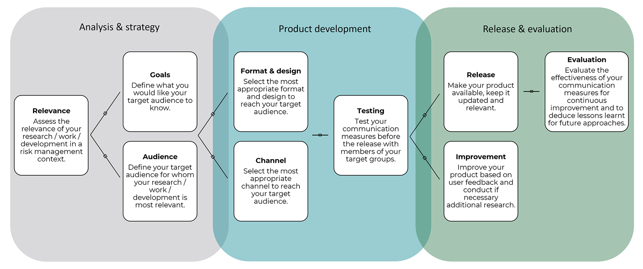
Figure 1Flowchart visualising the principle process steps to adhere to when designing communication products. Adapted from Marti et al. (2020).
1.2 The process for the release
Developing as well as updating seismic hazard and risk models is primarily a scientific task. Making the results accessible to a wider audience is, however, a joint effort of model developers and stakeholders, IT specialists, and communication experts. We based our approach for the launch of the two models (i.e. ESHM20 and ESRM20) on the schema depicted in Fig. 1.
An interdisciplinary core team structured the work accordingly and jointly developed the strategy as well as the communication products. The progresses and different product versions were regularly presented to a larger group of experts in seismic hazard and risk assessment, who provided detailed feedback. The virtual meetings were planned thoroughly, allowing the assimilation of feedback from such a large group as efficiently as possible. We often worked with virtual collaboration tools and regularly conducted short surveys inviting everyone to contribute.
The first step of the schema foresees assessing the relevance of the information to be distributed. As illustrated in the introduction, political and societal support is needed to advance earthquake mitigation strategies, which are informed by the results of the models. In the following, the subsequent steps leading to the launch of the models are shown.
1.2.1 The communication concept
Besides the data, codes, and models that are openly available on a public GitLab repository (https://gitlab.seismo.ethz.ch/efehr, last access: 30 January 2024) (Crowley et al., 2020, 2021, 2023; Danciu et al., 2021; Romão et al., 2021; Weatherill, 2023a, b), further products were needed for the public release of the model (e.g. maps; Fig. 5). To this end, the model developers at the EUCENTRE and the Swiss Seismological Service (SED) at ETH Zurich and the communication team at SED joined forces and developed products tailored to the target audiences' needs and knowledge; thus, this core team was responsible for the corporate communication (Christensen and Cornelissen, 2013) by managing all communications related to the ESHM20 and ESRM20.
The basis of these efforts was the elaborated communication concept, which follows the theoretical frameworks of Zerfaß and Piwinger (2014). In this concept, we defined the communication strategy, the realisation plan, and the controlling and evaluation mechanisms. Regarding the controlling mechanism, we on the one hand checked to what extent the formulated objectives are achieved through the realised communication activities (result control) and, on the other hand, whether the project is on schedule or if actions are necessary (process control); see specific examples later in the paper.
More precisely, the communication concept defined the overall vision, the communication principles and goals, the target audiences, the products, and the dissemination channels and activities. Regarding the target audiences, we created the so-called “personas”. Personas are characters that represent a subgroup for whom specific communication products are designed and created. The definition of the personas includes the professional background, interests, expertise, and specific use of the product (Smith, 2012). This concept has already been used in other contexts where international communication products were developed (Getto and Amant, 2015). Regarding the communication goals, we identified which goals address end-users' hazard and risk awareness, their attitudes, and their actual behaviours (Bruhn and Herbst, 2016).
1.2.2 The design and testing of the products
To design user-centred products, testing is indispensable (Dallo et al., 2022a; Karjack et al., 2022; Marti et al., 2023; Schneider et al., 2023a). The earthquake hazard and risk maps of Europe were two of the main products that were also integrated into many other products (e.g. flyers, posters). Maps are commonly used to communicate spatial hazard and risk but are only an appropriate format if they are well designed (Marti et al., 2019; Schneider et al., 2023a). Experiences show that colour scales are often chosen based on subjective preferences and not empirical evidence (Thompson et al., 2015).
The consequences of unsuitable colour scales are manifold: (i) manipulation or distortion of data (Crameri et al., 2020), (ii) inaccessibility for people with a colour-vision deficiency (Crameri et al., 2020), (iii) impossible colour discriminability (Bujack et al., 2018), (iv) misunderstandings of the actual hazard especially by non-scientific users (Dasgupta et al., 2020), and (v) loss of meaning when printed in black and white (Crameri et al., 2020). Thus, the colour scale is a critical element on the map especially because it is considered pre-attentive, which means that the eye extracts information intuitively and rapidly (Sherman-Morris et al., 2015).
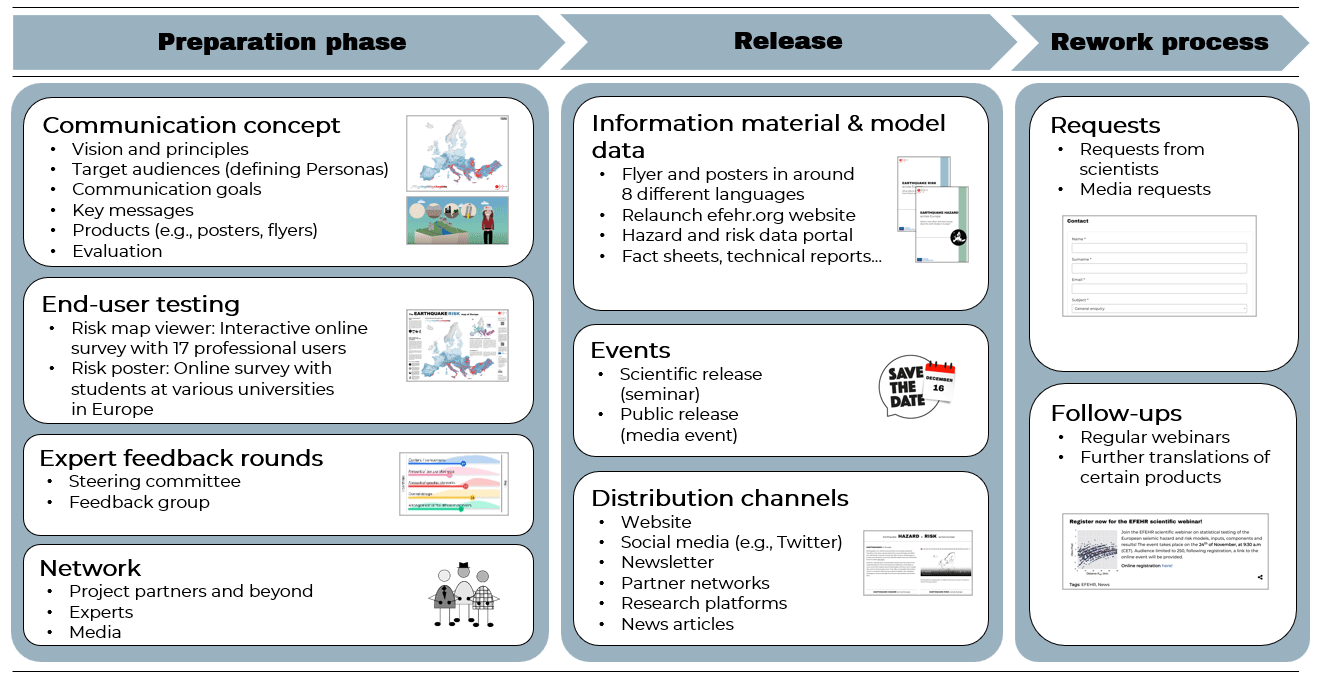
Figure 2Overview of the communication strategy for the public release of the ESRM20 and ESHM20.
But there are solutions for these challenges. Crameri et al. (2020) offer various colour palettes that are colour-blind-friendly such as the batlow palette. Robertson and O'Callaghan (1986) further recommend using linear progressions in colour lightness across the entire scale in order to guarantee perceptual uniformity (i.e. a unit increase in data value corresponds to a unit increase in the perception of change between colours). Schneider et al. (2023a) additionally provide a criteria-based framework for the design of hazard maps demonstrated by the design of the German seismic hazard map (Grünthal et al., 2018). However, for cross-country maps one must also take into account that what people associate with specific colours is culture-specific (Wang et al., 2014).
Besides the colour scale, also the map-related elements such as the legend, title, or textual explanations matter. For example, Edler et al. (2020), from a cartographic perspective, recommend positioning the legend on the right side of the map since this can lead to a faster processing of the information. Further, to increase end-users' trust and confidence in the products, the source should be indicated and well visible (Sullivan-Wiley and Short Gianotti, 2017; Wood et al., 2018). Moreover, pictograms and icons trigger people to take action and allow persons not speaking the language in which the information is written to grasp the context (e.g. key messages, or what they should do) (Dallo et al., 2022b). Further, people prefer a combination of textual and visual information (Becker et al., 2018; Dallo et al., 2020), which also ensures that people with different cognitive abilities can look at the format that is understandable for them.
For the ESRM20 and ESHM20, we decided to test the interactive risk web viewer and the risk poster including the corresponding map. For both products we conducted an online survey, once with professional users and once with students from European universities. We argue that the insights from the surveys are also valid for the wider public since several studies have shown that well-educated and trained people (e.g. non-technical audiences) have no advanced abilities in interpreting scientific graphs (McMahon et al., 2015; Maltese et al., 2015).
1.3 The scope of the paper
Figure 2 shows the overview of our communication strategy for the public release of the ESRM20 and ESHM20: from the preparation phase over the release to the rework process. In this paper, we focus on the preparation phase, namely the communication concept (Sect. 2), the user testing (Sect. 3), the expert feedback mechanisms (Sect. 4), and the networking with outreach specialists (Sect. 5).
As mentioned in Sect. 1.2.1, our communication concept followed the structure of Zerfaß and Piwinger (2014). In the following, we describe the core elements of the concept.
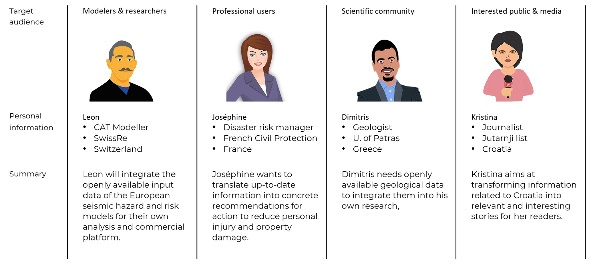
Figure 3The four personas who represent the target audiences of the ESRM20 and ESHM20. Icons created by Pixabay.
2.1 Vision and principles
As a first step, it is crucial to define the vision and the principles of the project in order to guarantee that all project members work towards common goals and communicate according to the same principles. This allows one to build a shared overall vision of what should be achieved with the release of the models. The overall vision of the project was to provide cross-border harmonised hazard and risk models for Europe. Regarding the principles, we, for example, committed to (i) communicate transparently and openly, (ii) guarantee consistency and continuity, (iii) provide comprehensive knowledge on earthquake hazard and risk, and (iv) support cooperation among the internal project group and foster engagement with external stakeholders.
2.2 Target audiences and personas
The second step was the definition of the target audiences of our communications. As the models were of great interest to many stakeholders, we first compiled a list with all of them. Together with the involved partners, we then categorised the target audiences into four groups, each of which we defined a persona for (Fig. 3). Personas are fictional characters representing a subset of the target audiences (Getto and Amant, 2015), summarising typical requirements (e.g. interests) of the subset as comprehensively as possible (Smith, 2012). In our case, we summarised their interests and needs regarding the release of the earthquake hazard and risk models. The benefit is to reduce complexity, better tailor the products to the target audiences' needs, and to re-check decisions throughout the product designing process.
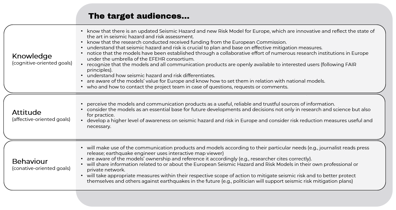
Figure 4The communication goals aligned to the three dimensions knowledge, attitude, and behaviour. Adapted from Bruhn and Herbst (2016).
2.3 Communication goals
We defined 15 communication goals that indicated what we aimed to achieve with our communication efforts. The goals were further grouped into three dimensions that build on each other: knowledge (i.e. cognitive-oriented), attitude (i.e. affective-oriented), and behaviour (i.e. conative-oriented) (Bruhn and Herbst, 2016); see Fig. 4. This differentiation makes sure that not only general information is communicated but that the target audiences' perception and actual use of the products are addressed by the communication efforts.
2.4 Key messages
The next step in the communication concept was to derive key messages based on the target audiences and communication goals (Röttger, 2016). Insights from the testing (see Sect. 3) served as valuable inputs in the definition of the messages. In total, we defined a set of 33 key messages, whereas 5 of them were defined as overarching key messages: The 2020 European Seismic Risk Model is the first openly available earthquake risk assessment at a European level presenting the potential consequences earthquakes may have on the built environment.
The other 28 key messages were clustered into eight sub-topics: (i) importance of the models, (ii) hazard model, (iii) risk model, (iv) relation to national models, (v) joint development, (vi) access to data, (vii) citation, and (viii) additional materials. The key messages were used to integrate the content and thus to ensure that the messages are consistent across different products or platforms. However, not all these messages were always used in each product. Depending on the context (e.g. product, communication goals, and target groups), different aspects were emphasised content-wise and therefore only particular messages were used.
The key messages were aligned with the communication goals to ensure that all goals are addressed. To this end, we checked which communication goals are reached by each of the eight key message sub-topics. For example, one communication goal was to have two clear citations – one for the risk model and one for the hazard model – which researchers and the media should use to refer to the models. This is crucial to measure the impact of the models. One related key message thus was as follows: Whenever making use of scientific products or when distributing visualisations of Europe's earthquake hazard and risk models, please cite the respective technical reports: [citation risk & citation hazard].
This key message was indicated on each communication product and mentioned in several places on the EFEHR website as well as on the map viewers of both hazard (http://hazard.efehr.org/en/home/, last access: 30 January 2024) and risk (http://risk.efehr.org/, last access: 30 January 2024) web services. By doing so, it allowed us to minimise the problem that emerged for the release of the ESHM13 (Woessner et al., 2015), where the model was cited in various ways; thus, it was impossible to measure the outreach of the model and acknowledge the developers appropriately.
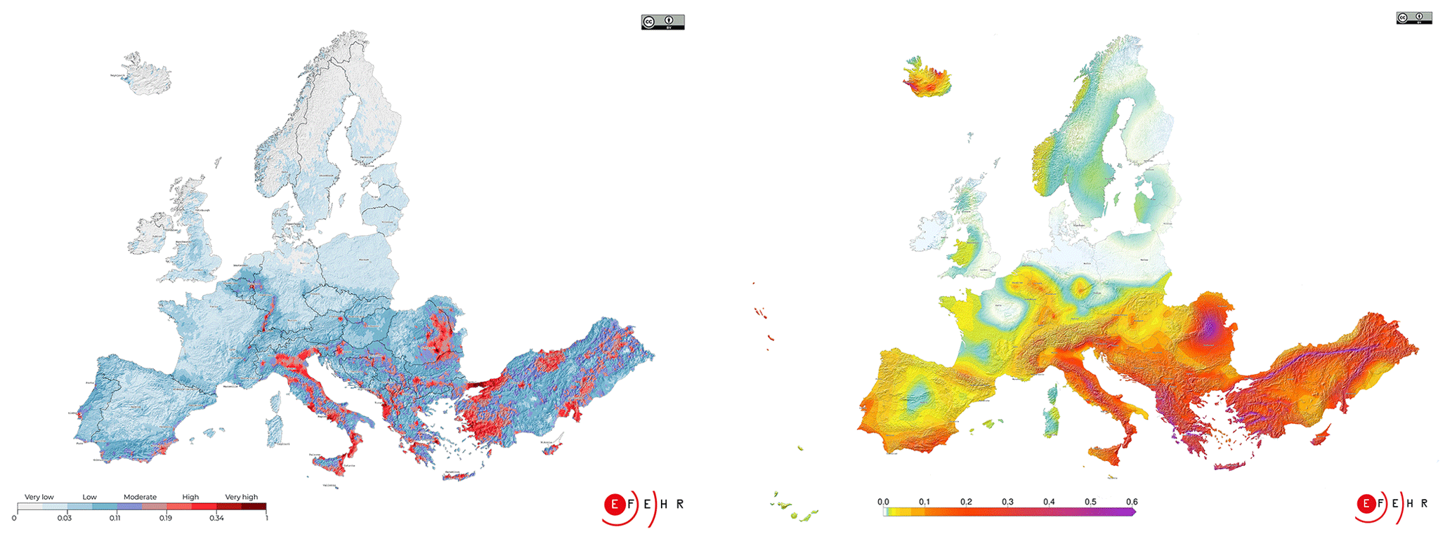
Figure 5The European seismic risk (on the left) and hazard map (on the right). The seismic risk map shows the risk index which combines the average annual economic loss and the average annual loss of life. The seismic hazard map shows the expected level of ground shaking, measured as peak ground acceleration (http://www.efehr.org/explore/Downloads-information-material/, last access: 30 January 2024).
Table 1Overview of the products and their target audiences (Fig. 3) for the public release of the two models, which are available under http://www.efehr.org/explore/Downloads-information-material/ (last access: 30 January 2024).
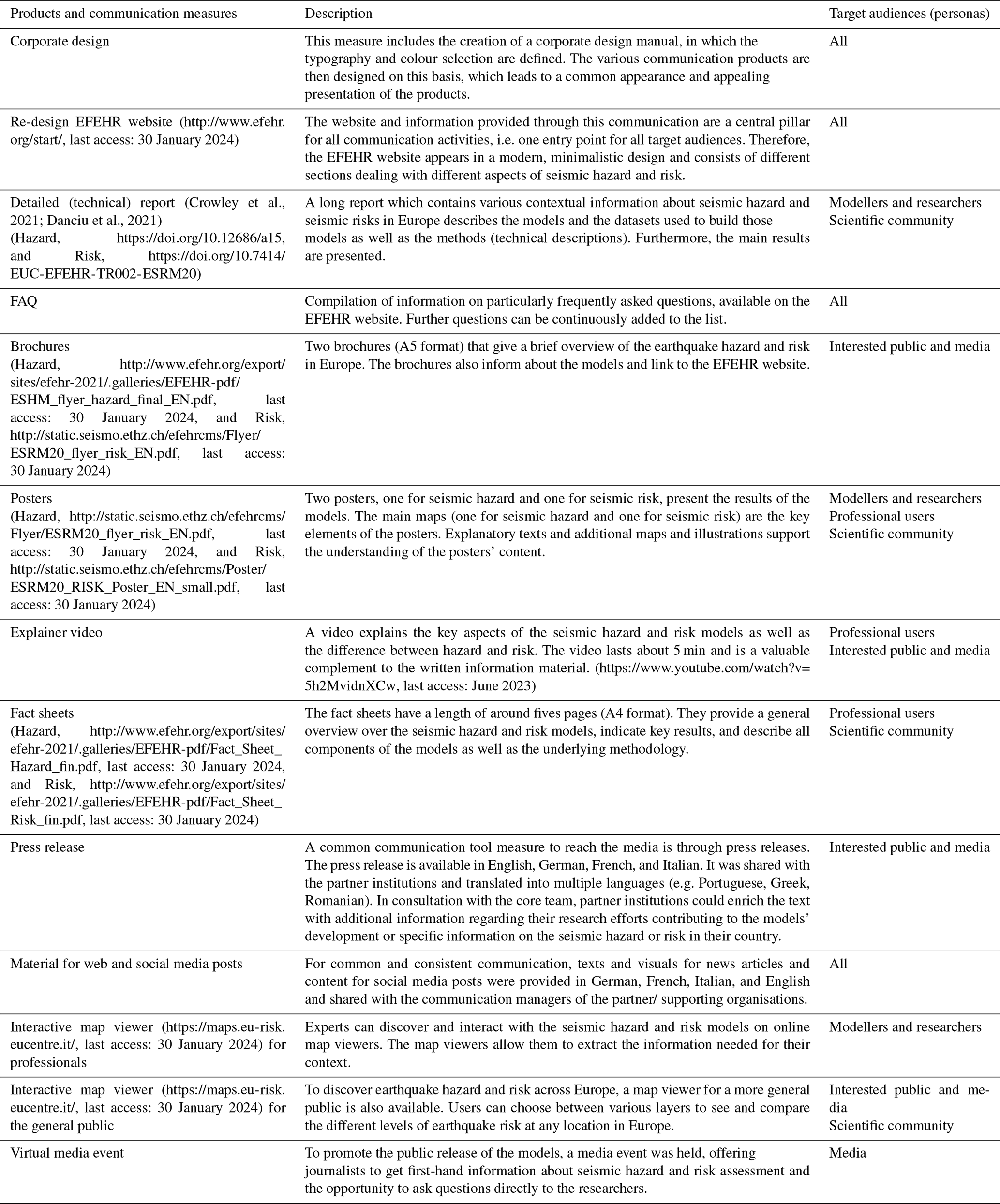
2.5 Products
Next, the products for the public release of the two models were defined. The development of these products was iterative; the core team always created a first draft, collected feedback from the feedback groups or did testing, and then adjusted and finalised the products. In Table 1, we provide an overview of all products with a short description and their primary target audiences, and in Fig. 5 we show the final risk and hazard map of ESRM20 and ESHM20, respectively. All products are available on the EFEHR website (http://www.efehr.org/explore/Downloads-information-material/, last access: June 2023). Some products, such as the detailed technical reports or the fact sheets, are available in English, and others such as the official poster or flyer are available even in several languages (e.g. English, German, French, Italian, Greek, Portuguese, Romanian). Partner institutions in the respective countries provided the translations.
2.6 Evaluation
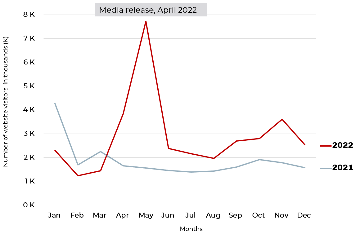
To control the usefulness and effectiveness of our communication efforts, we had various evaluation mechanisms. On the one hand, we collected the web statistics and compared them with previous years (e.g. website visitors, product downloads). For example, we had on average 1880 website visitors per month in 2021 and about 1000 more in 2022 (2890 visitors per month). In Fig. 6, the increase after the public release at the end of April 2022 is visible, with a total of 7721 visitors in May. Even in the months following this peak due to the release, the numbers remained at a higher level than before. Furthermore, the EFEHR website is highly accessed after severe events, such as the devastating Türkiye–Syria earthquake on 6 February 2023 demonstrated, when more than 32 000 persons accessed the EFEHR website.
On the other hand, we have collected the news articles which provide information about the models. To this end, we prepared a joint Excel file where the outreach specialists from our established partner network (see Sect. 5) were asked to add their articles and those they came/come across. Our outreach efforts worked well, as the various articles in newspapers or online magazines (∼ 37), articles on websites or newsletters (∼ 14), as well as numerous posts on social media channels, and a few TV/radio interviews showed (as at November 2022). The news articles were published by different media outlets across Europe, e.g. EuroNews, Neue Zürcher Zeitung (Switzerland), Daily Express (UK), Greek Reporter, SOL (Portugal), Critic National Romania, and ANSA (Italy).
We decided to test two different products: the interactive risk web viewer for professional users (http://risk.efehr.org/, last access: 30 January 2024) and the official risk poster with a special focus on the risk map. For both products, we conducted an online survey to assess the correct comprehension, perceived usefulness, and design and content preferences. For the risk poster, we further did a between-subject experiment to identify which colour scale and shading work best. In Sects. 3.1 and 3.2, we describe the two testing studies in detail and summarise the main practical insights.
The hazard web platform and hazard map were not tested within this effort. However, the hazard poster consists of the same design elements as the risk poster, thus applying the lessons learnt from the user testing described below. In addition, the hazard map was adapted to the colour bar recommendation and reviewed and approved by the feedback group.
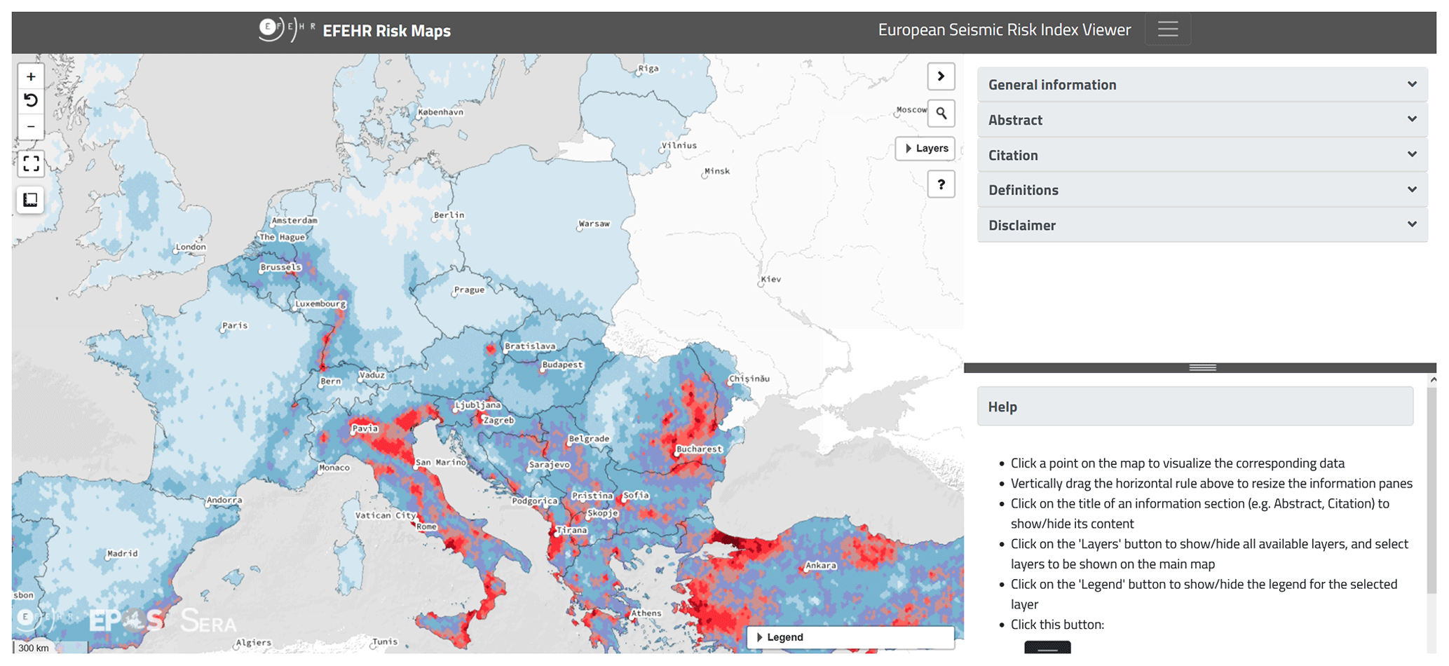
Figure 7EFEHR interactive seismic risk map viewer (https://maps.eu-risk.eucentre.it/map/european-seismic-risk-index-viewer/#4/52.64/5.05, last access: 30 January 2024).
3.1 Web viewer of the risk model
In December 2020, we conducted an interactive online survey with 17 professional users of the risk web viewer (Fig. 7), representing researchers, civil engineers, cat risk modellers, and civil protection (Fig. S1 in the Supplement). The aim of the survey was to assess the user needs with respect to the information presented on the web viewer, i.e. its relevance, usability, understandability, user friendliness, and completeness.
In four question blocks (QBs), we assessed the user needs. In QB1, before seeing the beta version of the web viewer, participants had to indicate what information they would expect on the map viewer. This allowed us to validate whether participants' expectations were in line with the actual content. In QB2, we assessed participants' correct interpretation of the information provided, map and layer preferences, and additional information needs. In QB3, we let them evaluate the design, and, in QB4, they had the chance to provide final comments. The entire questionnaire is listed in Supplement S1. The survey was set up with Unipark at ETH Zurich, and the results were statistically analysed with the software SPSS.
Table 2Summary of the practical implications for designing an interactive web viewer for risk models. All descriptive results are listed in Supplement S2.
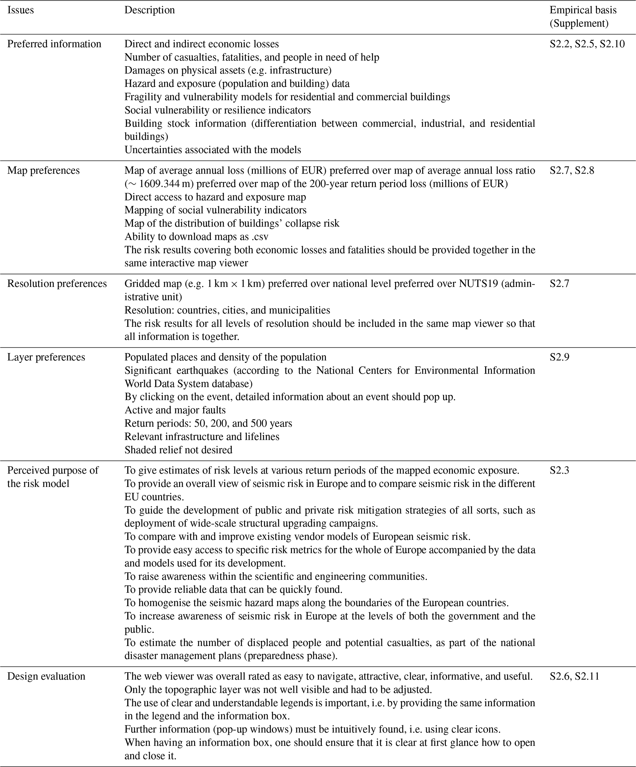
In Table 2, we summarise the practical implications from the survey results that we used to improve the clarity of the web viewer and the additional information requested by the users. Overall, the two primary benefits of the ESRM20 are the enhancement of existing services/products and the development of new ones as stated by the participants (Figs. S2 and S3 in the Supplement). All descriptive results are listed in Supplement S2.
3.2 Risk poster and risk map
We conducted an online survey with 83 students across Europe to test the risk poster in July 2021. The aims were to assess (i) whether the communication goals are reached with the information on the poster; (ii) whether the risk information on the poster is understood correctly, perceived as useful and well designed, and complete; and (iii) what influence the design (colour scale) and participants' characteristics – numeracy skills, colour blindness, field of study, university, age, gender, and living place – have on these factors.

Figure 8The three risk map versions we tested alone and integrated in the poster. The feature that was varied was the colour scale.
We developed three versions of the risk map with three different colour scales (see Fig. 8). We thus tested three versions of the risk poster by replacing the map in the middle (Table S8 in the Supplement), whereas all the other poster elements stayed the same. To test which version works best, we conducted a between-subject experiment; thus participants were randomly assigned to one of the three poster versions but responded to the same questions. The same was done for the risk map only.
The survey consisted of three question blocks (QBs). In QB1, participants saw one of the three risk poster versions (between-subject experiment), and we assessed participants' first impression, correct interpretation, personal use, and design preferences. In QB2, participants then only saw one of the three risk map versions (between-subject experiment), and we again asked about their first impression, correct interpretation, and design preferences. Furthermore, we tested different shading and contour variations by always showing two maps side by side and letting participants choose which one they prefer. In QB3, we assessed participants' characteristics to analyse whether these have an influence on their preferences, perceived usefulness, and correct interpretation. The entire questionnaire is listed in Table S9 in the Supplement.
In total, 83 students with a mean age of 30.8 (SD = 10.2) filled in the survey; 59 % of the participants were female and 41 % male, and the majority lived in Switzerland, Romania, Italy, or France. The majority has either a master's degree (37.3 %) or a bachelor's degree (27.7 %), mainly in the fields of engineering (44.6 %), earth sciences (16.9 %), geophysics (7.2 %), architecture (7.2 %), or environmental sciences (6.0 %). All characteristics are listed in Table S10 in the Supplement. The sample characteristics did not differ significantly across the experimental groups (Tables S11 and S12 in the Supplement).
Table 3Practical implications for designing comprehensive, useful, and well-perceived risk maps and posters. All descriptive results of the survey are listed in Supplement S6.
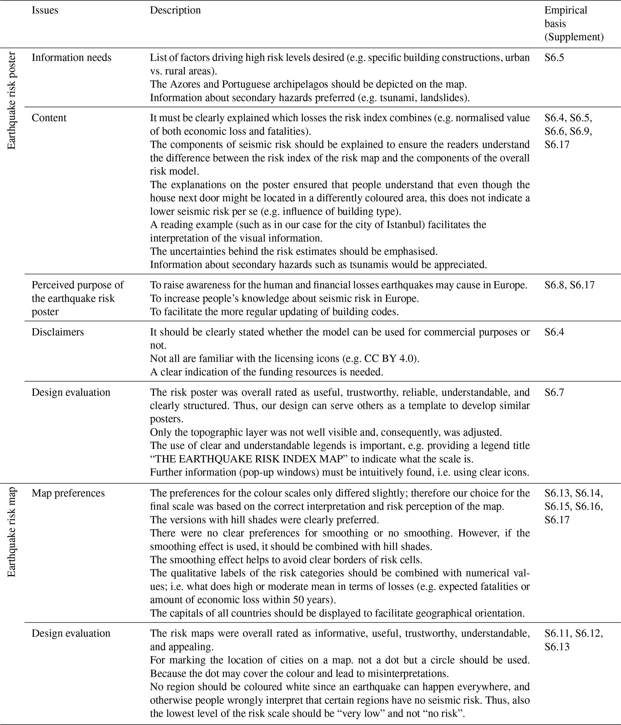
In Table 3, we summarise the main practical implications that we used to adjust the map and poster design to the users' needs, preferences, and comprehension skills. Overall, the participants correctly grasped from the risk posters that earthquakes pose a serious threat to Europe and that certain regions in Italy, Greece, and Türkiye face especially high earthquake risk (Supplement S6.3). When looking only at the risk map, participants recognised that southern Europe (including Italy and Türkiye) is most affected (Supplement S6.10). Further, they indicated that they learned something new about earthquakes in Europe, which shows the successful knowledge transfer via the risk poster (M = 3.46, SD = 1.12; Supplement S6.8). Moreover, the majority is also motivated to share the gained information with their colleagues (M = 3.39, SD = 1.14; Supplement S6.8). All descriptive results of the survey are listed in Supplement S6.
Regarding the design, we here discuss the aspects relevant for the final choice of the colour scale and risk index. First, our decision is ground in choosing a colour scale that ensures that people correctly interpret the map (Table S14 in the Supplement). Second, with the selected colour scale, people better understood that although the house next door might be located in a differently coloured area, this does not indicate a lower seismic risk per se (e.g. influence of building type). An effective visual technique for conveying this information involved incorporating a gradient or fading of colours. Third, we explicitly state on the poster and other products that the map illustrates a risk index, representing the average annual economic loss and the average annual loss of life. In the case of the Swiss earthquake risk map, we went one step further by clearly indicating the risk index and its two underlying components in the legend too, a measure proven to improve public comprehension of the map (Dallo et al., 2024).
The model developers and the communication experts built the core team (the authors) and took the lead in the product development and the scientific as well as public release of the models. Meetings were held fortnightly and in the final phase even weekly, among other things, to discuss preliminary product versions and the status of the project plan and prepare presentations for the wider expert group and release.
To guarantee high-quality products, we created two expert groups, namely the “feedback group” and “steering committee”. The feedback group consisted of persons who were involved in the development of the hazard and risk models, most of which are also part of the EFEHR Executive Committee. The steering committee contained four persons (i.e. EFEHR's Consortium Chair, SERA and RISE project coordinators, GEM's Secretary General). We met monthly with both groups, and they had the chance to give their inputs to all products. To this end, we had a collaborative online repository where they could provide feedback in parallel while seeing what the others had already commented on or changed. For the feedback rounds during the meetings, we used Mentimeter (https://www.mentimeter.com, last access: 30 January 2024), which allowed us to directly show their preferences and opinions, discuss disagreements, and take final decisions in which direction to go. Moreover, since not all were able to join every meeting, we always sent the meeting notes and presentations to everyone, collected written feedback, or offered bilateral meetings if needed.
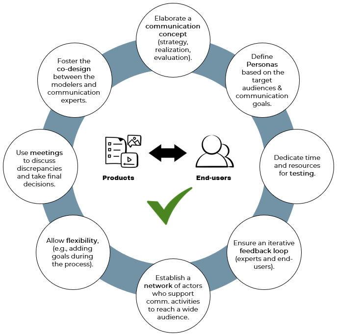
Figure 9Overview of practical recommendations (in the circles) on how to achieve products accessible for and effectively used by the end-users. Icons created by smashingstocks – Flaticon.
In preparation for the public release of the model, three issues were relevant. First, we had to establish a network with outreach specialists of project partners and beyond. We used our personal networks and actively reached out to other stakeholders and the media.
Second, we created a virtual media kit to share various communication materials (e.g. press release, high-resolution maps) with the journalists, so that they could use them for their news articles or TV contributions. This media kit was also provided to all outreach specialists of our established network.
Third, we appointed so called EFEHR ambassadors. These “EFEHR ambassadors” were earthquake hazard or risk experts from different European countries who were available to answer media requests in the respective language of the country and who were familiar with local conditions. These contact persons received instructions and information materials (e.g. key messages, key facts) to be ready to answer specific questions, making sure that they communicated consistent information.
6.1 Key practical recommendations
Figure 9 provides an overview of practical recommendations for the design of (inter)national outreach activities to support the release of updated or newly developed hazard and risk models. To this end, each step of the communication strategy is relevant: (i) the preparation phase including the communication concept, end-user testing, expert feedback rounds, and the outreach specialists network; (ii) the release of the information materials and model data at events and via the distribution channels; and (iii) the rework process to answer requests, offer training and webinars, and evaluate the outreach activities.
Thereby, the backbone of a communication strategy is the communication concept, in which the vision, communication goals, target audiences, key messages, products, and communication measures are defined. To reduce complexity when aiming at targeting a wide range of target audiences, we recommend the use of personas. Personas represent typical characteristics of the target audiences. The communication concept should further be flexible and adjustable since new insights (e.g. from product testing) may emerge throughout the process, and, consequently, communication goals or key messages may have to be revised.
The testing of key products is seen as an indispensable part of the communication strategy to ensure that they fulfil end-users' needs and preferences. Consequently, best practices in communicating seismic hazard and risk information need to be adopted, evaluated, and considered for the product design. To this end, model developers and communication experts must closely collaborate and consider inclusive design approaches. Such an iterative design process is elaborate and time-consuming, two factors that must be accounted for when defining resources and timelines.
Additionally, to ensure that the products are also coherent and correct in terms of content, feedback from experts in the respective fields is needed. A challenge thereby is to find the right balance between expert requirements and user needs. To support joint decision taking, we used an interactive tool during meetings with the experts, which allowed us to visualise (different) viewpoints and come to an agreement. To obtain written feedback, we recommend using a virtual platform, where experts can in parallel add comments, observe what others have already changed, and directly react to certain aspects.
With a clear strategy, an interdisciplinary team, and the involvement of the target audiences, communication products can be designed that are valuable and useful to support decision taking. Thereby, it is important that not only the technical data, but also all outreach materials are openly available and easily accessible, which we for example ensured via the EFEHR website for the European seismic hazard and risk models. We are convinced that the chosen approach is not only useful in this context, but also could be applied to any domain, where complex scientific findings should be made accessible to diverse target audiences.
The effectiveness of the approach's transferability is, for instance, demonstrated through its successful application in developing Switzerland's first publicly available earthquake risk model (Dallo et al., 2023; Marti et al., 2023) or in redesigning the seismic hazard map for Germany (Schneider et al., 2023a). A transdisciplinary approach is currently also used by the United States Geological Survey (USGS) to design products for aftershock forecasts in various countries (Schneider et al., 2023b). They have already used user testing for the evaluation of the rapid impact assessment they release after significant earthquakes (Karjack et al., 2022). This approach is also partially utilised and under consideration for the future development of socially relevant assets within the framework of the European Plate Observing System (EPOS; Marti et al., 2022).
6.2 Closing words
This paper provides insights on how to co-define a communication strategy – including a communication concept, user testing, and expert feedback mechanisms – for cross-country hazard and risk models to ensure user-centred, high-quality products for the target audiences (scientific community and societal stakeholders). The insights from our strategy should support future efforts on national and international levels, such as the ongoing process to develop European operational earthquake forecasts (Han et al., 2023) and international aftershock forecasts (Schneider et al., 2023). We emphasise that a close collaboration between the model developers and communication experts as well as an iterative development process is key to the success and the long-term relevance of the models, which, in our case, was again proven by the high access rates of the ESHM and ESRM products after the devastating Türkiye–Syria earthquake on 6 February 2023.
The code mentioned in this study is openly available on the GitHub repository (https://gitlab.seismo.ethz.ch/efehr/eshm20_gmms, Weatherill, 2023a and https://gitlab.seismo.ethz.ch/efehr/esrm20_sitemodel, Weatherill, 2023b).
The datasets mentioned in this study are openly available on the repositories GitLab (https://doi.org/10.5281/zenodo.5728008, Crowley et al., 2023) and Zenodo (https://doi.org/10.5281/zenodo.4062044, Crowley et al., 2020 and https://doi.org/10.5281/zenodo.4062410, Romão et al., 2021).
The supplement related to this article is available online at: https://doi.org/10.5194/nhess-24-291-2024-supplement.
We use the CRediT contributor roles taxonomy to categorise author contributions. Conceptualisation (communication strategy and user testing): ID, MM (lead), NV, HC, LD, JD, SZ. Resources (developing communication products): MM, NV, HC, LD, JD, SZ. Feedback on communication products: ID, FC, DG, RP, JS, CB, AAC, OJK, PM, MP, VS, GW, SW. Methodology (communication concept and related issues): MM, NV, HC, LD, JD. Investigation (user testing: data collection and analysis): ID. Writing – original draft: ID, NV. Writing – review and editing: MM, HC, JD, LD, SZ, FC, DG, RP, JS, CB, AAC, OJK, PM, MP, VS, GW, SW. Funding: DG, SW. Project investigators; DG, SW. Core team leading the communication strategy and doing the user testing: ID, MM, NV, HC, JD, LD, SZ. Steering committee: FC, DG, RP, JS, SW. Feedback group: AAC, OJK, PM, MP, VS, GW.
The contact author has declared that none of the authors has any competing interests.
Publisher's note: Copernicus Publications remains neutral with regard to jurisdictional claims made in the text, published maps, institutional affiliations, or any other geographical representation in this paper. While Copernicus Publications makes every effort to include appropriate place names, the final responsibility lies with the authors.
This article is part of the special issue “Harmonized seismic hazard and risk assessment for Europe”. It is not associated with a conference.
The authors would like to thank the EFEHR ambassadors (Josip Atalić, Philippe Gueguen, Gottfried Grünthal, Kyriazis Pitilakis, Vassilis Karastathis, Benedikt Halldórsson, Sevgi Ozcebe, Radmila Salic Makreska, Mathilde B. Sørensen, Radu Vacareanu, and Constantin Ionescu) for supporting the outreach of the communication products and release of the models. Further, we thank all participants for filling in the survey on the interactive web viewer or the risk poster. The authors also thank the two reviewers for their valuable comments, which strongly improved the clarity of our article.
Opinions expressed in this paper solely reflect the authors' view; the EU is not responsible for any use that may be made of information it contains.
This research has been supported by the Horizon 2020 (grant nos. 730900, 821115, and 101021746).
This paper was edited by Mathilde Sørensen and reviewed by two anonymous referees.
Becker, J. S., McBride, S. K., Potter, S. H., Gerstenberger, M. C., and Christophersen, A.: Effective communication of Operational Earthquake Forecasts (OEF): findings from a New Zealand workshop, Lower Hutt, NZ, GNS Science report 2016/45, GNS Science, p. 49, https://doi.org/10.21420/G2DH00, 2018.
Bruhn, M. and Herbst, U.: Kommunikation für Nonprofit-Organisation, in: Handbuch Instrumente der Kommunikation, edited by: Bruhn, M., Esch, F.-R., and Langner, T., Springer Fachmedien Wiesbaden, Wiesbaden, 605–622, https://doi.org/10.1007/978-3-658-04655-2_29, 2016.
Bujack, R., Turton, T. L., Samsel, F., Ware, C., Rogers, D. H., and Ahrens, J.: The good, the bad, and the ugly: a theoretical framework for the assessment of continuous colormaps, IEEE T. Vis. Comput. Gr., 24, 923–933, https://doi.org/10.1109/TVCG.2017.2743978, 2018.
Christensen, L. T. and Cornelissen, J.: Bridging corporate and organizational communication: review, development and a look to the future, in: Organisationskommunikation und Public Relations, edited by: Zerfaß, A., Rademacher, L., and Wehmeier, S., Springer Fachmedien Wiesbaden, Wiesbaden, 43–72, https://doi.org/10.1007/978-3-531-18961-1_3, 2013.
Crameri, F., Shephard, G. E., and Heron, P. J.: The misuse of colour in science communication, Nat. Commun., 11, 5444, https://doi.org/10.1038/s41467-020-19160-7, 2020.
Crowley, H., Despotaki, V., Rodrigues, D., Silva, V., Costa, C., Toma-Danila, D., Riga, E., Karatzetzou, A., Fotopoulou, S., Sousa, L., Ozcebe, S., Gamba, P., Dabbeek, J., Romão, X., Pereira, N., Castro, J. M., Daniell, J., Veliu, E., Bilgin, H., Adam, C., Deyanova, M., Ademović, N., Atalic, J., Bessason, B., Shendova, V., Tiganescu, A., Zugic, Z., Akkar, S., Hancilar, U., and Exposure Contributors: European Exposure Model Data Repository (Version 1.0) [Data set], Zenodo [data set], https://doi.org/10.5281/zenodo.4062044, 2020.
Crowley, H., Dabbeek, J., Despotaki, V., Rodrigues, D., Martins, L., Silva, V., Romão, X., Pereira, N., Weatherill, G., and Danciu, L.: European Seismic Risk Model (ESRM20), EFEHR Technical Report 002, V1.0.1., EFEHR, https://doi.org/10.7414/EUC-EFEHR-TR002-ESRM20, 2021.
Crowley, H., Dabbeek, J., Danciu, L., Kalakonas, P., Riga, E., Silva, V., Veliu, E., and Weatherill, G.: Earthquake Scenario Loss Testing Repository (Version 1.1) [Data set], Zenodo [data set], https://doi.org/10.5281/zenodo.5728008, 2023.
Dallo, I., Stauffacher, M., and Marti, M.: What defines the success of maps and additional information on a multi-hazard platform?, Int. J. Disast. Risk Re., 49, 101761, https://doi.org/10.1016/j.ijdrr.2020.101761, 2020.
Dallo, I., Stauffacher, M., and Marti, M.: Actionable and understandable? Evidence-based recommendations for the design of (multi-)hazard warning messages, Int. J. Disast. Risk Re., 74, 102917, https://doi.org/10.1016/j.ijdrr.2022.102917, 2022a.
Dallo, I., Marti, M., Clinton, J., Böse, M., Massin, F., and Zaugg, S.: Earthquake early warning in countries where damaging earthquakes only occur every 50 to 150 years – The societal perspective, Int. J. Disast. Risk Re., 83, 103441, https://doi.org/10.1016/j.ijdrr.2022.103441, 2022b.
Dallo, I., Schnegg, L. N., Marti, M., Fulda, D., Papadopoulos, A. N., Roth, P., Danciu, L., Valenzuela, N., Wenk, S. R., Bergamo, P., Haslinger, F., Fäh, D., Kästli, P., and Wiemer, S.: Designing understandable, action-oriented, and well-perceived earthquake risk mapsthe Swiss case study, Front. Commun., 8, 1306104, https://doi.org/10.3389/fcomm.2023.1306104, 2024.
Danciu, L., Nandan, S., Reyes, C., Basili, R., Weatherill, G., Beauval, C., Rovida, A., Vilanova, S., Sesetyan, K., Bard, P.-Y., Cotton, F., Wiemer, S., and Giardini, D.: The 2020 update of the European Seismic Hazard Model: Model Overview, EFEHR Technical Report 001, v1.0.0, EFEHR, https://doi.org/10.12686/A15, 2021.
Dasgupta, A., Poco, J., Rogowitz, B., Han, K., Bertini, E., and Silva, C. T.: The effect of color scales on climate scientists' objective and subjective performance in spatial data analysis tasks, IEEE T. Vis. Comput. Gr., 26, 1577–1591, https://doi.org/10.1109/TVCG.2018.2876539, 2020.
Edler, D., Keil, J., Tuller, M.-C., Bestgen, A.-K., and Dickmann, F.: Searching for the `Right' legend: the impact of legend position on legend decoding in a cartographic memory task, Cartogr. J., 57, 6–17, https://doi.org/10.1080/00087041.2018.1533293, 2020.
Eurocode 8: Eurocode 8 – Design of structures for earthquake resistance – Part 1-1: General rules and seismic action, FprEN 1998-1-1 (draft), European Committee for Standardization (CEN), https://www.confinedmasonry.org/wp-content/uploads/2009/09/Eurocode-8-1-Earthquakes-general.pdf (last access: 30 January 2024), 2023.
Getto, G. and Amant, K. St.: Designing globally, working locally: using personas to develop online communication products for international users, Commun. Des. Q. Rev., 3, 24–46, https://doi.org/10.1145/2721882.2721886, 2015.
Grünthal, G., Stromeyer, D., Bosse, C., Cotton, F., and Bindi, D.: The probabilistic seismic hazard assessment of Germany – version 2016, considering the range of epistemic uncertainties and aleatory variability, B. Earthq. Eng., 16, 4339–4395, https://doi.org/10.1007/s10518-018-0315-y, 2018.
Han, M., Mizrahi, L., Dallo, I., and Wiemer, S.: Sequence-specific updating of European ETAS model: Application to the 2023 Türkiye-Syria earthquake sequence, EGU General Assembly 2023, Vienna, Austria, 24–28 Apr 2023, EGU23-17634, https://doi.org/10.5194/egusphere-egu23-17634, 2023.
Jiménez, M. J., Giardini, D., Grünthal, G., and SESAME Working Group: Unified seismic hazard modelling throughout the Mediterranean region, B. Geofis. Teor. Appl., 42, 3–18, 2001.
Karjack, S., Brudzinski, M. R., and Shipley, T. F.: Assessment of the general public's understanding of rapidly produced earthquake information products ShakeMap and PAGER, Seismol. Res. Lett., 93, 2891–2905, https://doi.org/10.1785/0220210318, 2022.
Maltese, A. V., Harsh, J. A., and Svetina, D.: Data visualization literacy: investigating data interpretation along the novice—expert continuum, Journal of College Science Teaching, 45, 84–90, 2015.
Marti, M., Stauffacher, M., and Wiemer, S.: Difficulties in explaining complex issues with maps: evaluating seismic hazard communication – the Swiss case, Nat. Hazards Earth Syst. Sci., 19, 2677–2700, https://doi.org/10.5194/nhess-19-2677-2019, 2019.
Marti, M., Stauffacher, M., and Wiemer, S.: Anecdotal evidence is an insufficient basis for designing earthquake preparedness campaigns, Seismol. Res. Lett., 91, 1929–1935, https://doi.org/10.1785/0220200010, 2020.
Marti, M., Haslinger, F., Peppoloni, S., Di Capua, G., Glaves, H., and Dallo, I.: Addressing the challenges of making data, products, and services accessible: an EPOS perspective, Ann. Geophys., 65, DM212, https://doi.org/10.4401/ag-8746, 2022.
Marti, M., Dallo, I., Roth, P., Papadopoulos, A. N., and Zaugg, S.: Illustrating the impact of earthquakes: Evidence-based and user-centered recommendations on how to design earthquake scenarios and rapid impact assessments, Int. J. Disast. Risk Re., 90, 103674, https://doi.org/10.1016/j.ijdrr.2023.103674, 2023.
McMahon, R., Stauffacher, M., and Knutti, R.: The unseen uncertainties in climate change: reviewing comprehension of an IPCC scenario graph, Climatic Change, 133, 141–154, https://doi.org/10.1007/s10584-015-1473-4, 2015.
Pohl, C., Klein, J. T., Hoffmann, S., Mitchell, C., and Fam, D.: Conceptualising transdisciplinary integration as a multidimensional interactive process, Environ. Sci. Policy, 118, 18–26, https://doi.org/10.1016/j.envsci.2020.12.005, 2021.
Robertson, P. K. and O'Callaghan, J. F.: The generation of color sequences for univariate and bivariate mapping, IEEE Comput. Graph., 6, 24–32, https://doi.org/10.1109/MCG.1986.276688, 1986.
Romão, X., Pereira, N., Castro, J. M., Crowley, H., Silva, V., Martins, L., and De Maio, F.: European Building Vulnerability Data Repository (v2.1) [Data set], Zenodo [data set], https://doi.org/10.5281/zenodo.4062410, 2021.
Röttger, U.: Einsatz der Public Relations im Rahmen der Unternehmenskommunikation, in: Handbuch Instrumente der Kommunikation. Grundlagen, innovative Ansätze, praktische Umsetzungen (2. Aufl.), edited by: Bruhn, M., Esch, F. R., and Langner, T., Springer Reference Wirtschaft, Wiesbaden, https://doi.org/10.1007/978-3-658-05261-4, 2016.
Schneider, M., Cotton, F., and Schweizer, P.-J.: Criteria-based visualization design for hazard maps, Nat. Hazards Earth Syst. Sci., 23, 2505–2521, https://doi.org/10.5194/nhess-23-2505-2023, 2023a.
Schneider, M., Wein, A., van der Elst, N., McBride, S. K., Becker, J., Castro, R., Diaz, M., Gonzalez-Huizar, H., Hardebeck, J., Michael, A., Mixco, L., Page, M., and Palomo, J.: Visual Communication of Aftershock Forecasts Based on User Needs: A Case Study of the United States, Mexico and El Salvador, OSF, https://doi.org/10.31219/osf.io/5qam4, 2023b.
Sherman-Morris, K., Antonelli, K. B., and Williams, C. C.: Measuring the effectiveness of the graphical communication of hurricane storm surge threat, Weather Clim. Soc., 7, 69–82, https://doi.org/10.1175/WCAS-D-13-00073.1, 2015.
Smith, J.: Defining and applying Personas to UX Design, Web Design Envato Tuts+, https://webdesign.tutsplus.com/defining-and-applying-personas-to-ux-design--webdesign-7561a (last access: 30 January 2024), 2012.
Sullivan-Wiley, K. A. and Short Gianotti, A. G.: Risk perception in a multi-hazard environment, World Dev., 97, 138–152, https://doi.org/10.1016/j.worlddev.2017.04.002, 2017.
Thompson, M. A., Lindsay, J. M., and Gaillard, J. C.: The influence of probabilistic volcanic hazard map properties on hazard communication, J. Appl. Volcanol., 4, 6, https://doi.org/10.1186/s13617-015-0023-0, 2015.
Wang, T., Shu, S., and Mo, L.: Blue or red? The effects of colour on the emotions of Chinese people, Asian J. Soc. Psychol., 17, 152–158, https://doi.org/10.1111/ajsp.12050, 2014.
Weatherill, G.: ESHM20 Ground Motion Models – Python Module [Code], GitLab [code], https://gitlab.seismo.ethz.ch/efehr/eshm20_gmms (last access: 30 January 2024), 2023a.
Weatherill, G.: Exposure to Site Tool – User Manual and Technical Guide [Code], GitLab [code], https://gitlab.seismo.ethz.ch/efehr/esrm20_sitemodel (last access: 30 January 2024), 2023b.
Woessner, J., Laurentiu, D., Giardini, D., Crowley, H., Cotton, F., Grünthal, G., Valensise, G., Arvidsson, R., Basili, R., Demircioglu, M. B., Hiemer, S., Meletti, C., Musson, R. W., Rovida, A. N., Sesetyan, K., Stucchi, M., and The SHARE consortium: The 2013 European Seismic Hazard Model: key components and results, B. Earthq. Eng., 13, 3553–3596, https://doi.org/10.1007/s10518-015-9795-1, 2015.
Wood, M. M., Mileti, D. S., Bean, H., Liu, B. F., Sutton, J., and Madden, S.: Milling and public warnings, Environ. Behav., 50, 535–566, https://doi.org/10.1177/0013916517709561, 2018.
Zerfaß, A. and Piwinger, M. (Eds.): Handbuch Unternehmenskommunikation: Strategie – Management – Wertschöpfung, Springer Fachmedien Wiesbaden, Wiesbaden, https://doi.org/10.1007/978-3-8349-4543-3, 2014.
- Abstract
- Introduction
- The communication concept
- User testing – the two online surveys
- Expert feedback rounds
- Networking with outreach specialists
- Conclusions
- Code availability
- Data availability
- Author contributions
- Competing interests
- Disclaimer
- Special issue statement
- Acknowledgements
- Financial support
- Review statement
- References
- Supplement