
Articles | Volume 26, issue 11
https://doi.org/10.5194/nhess-26-5647-2026
© Author(s) 2026. This work is distributed under
the Creative Commons Attribution 4.0 License.
the Creative Commons Attribution 4.0 License.
https://doi.org/10.5194/nhess-26-5647-2026
© Author(s) 2026. This work is distributed under
the Creative Commons Attribution 4.0 License.
the Creative Commons Attribution 4.0 License.
Research article
| 
05 Nov 2026
Research article |
| 05 Nov 2026
| 05 Nov 2026
Towards improved integration of hydrological uncertainty and hydraulic model sensitivity in flood hazard mapping

Chair of Hydrology and Hydraulic Engineering, Faculty of Civil and Geodetic Engineering, University of Ljubljana, Jamova 2, 1000 Ljubljana, Slovenia
Jasna Donevska
Chair of Hydrology and Hydraulic Engineering, Faculty of Civil and Geodetic Engineering, University of Ljubljana, Jamova 2, 1000 Ljubljana, Slovenia
Protim Ržišnik Perc Ltd., Ljubljana, Slovenia
Matjaž Mikoš
Chair of Hydrology and Hydraulic Engineering, Faculty of Civil and Geodetic Engineering, University of Ljubljana, Jamova 2, 1000 Ljubljana, Slovenia
Related authors
No articles found.
Nejc Bezak, Panos Panagos, Leonidas Liakos, and Matjaž Mikoš
Nat. Hazards Earth Syst. Sci., 23, 3885–3893, https://doi.org/10.5194/nhess-23-3885-2023, https://doi.org/10.5194/nhess-23-3885-2023, 2023
Short summary
Short summary
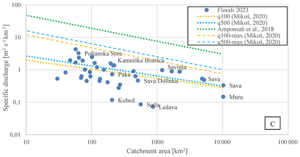
Extreme flooding occurred in Slovenia in August 2023. This brief communication examines the main causes, mechanisms and effects of this event. The flood disaster of August 2023 can be described as relatively extreme and was probably the most extreme flood event in Slovenia in recent decades. The economic damage was large and could amount to well over 5 % of Slovenia's annual gross domestic product; the event also claimed three lives.
Cited articles
Agopian, A., Hino, M., Siders, A. R., Samoray, C., and Mach, K. J.: A Nationwide Analysis of Community-Level Floodplain Development Outcomes and Key Influences, Earth's Future, 12, e2024EF004585, https://doi.org/10.1029/2024EF004585, 2024.
Aitken, G., Beevers, L., and Christie, M. A.: Advanced Uncertainty Quantification for Flood Inundation Modelling, Water, 16, 1309, https://doi.org/10.3390/w16091309, 2024.
Alfonso, L., Mukolwe, M., and Di Baldassarre, G.: Probabilistic Flood Maps to support decision-making: Mapping the Value of Information, Water Resour. Res., 52, 1026–1043, https://doi.org/10.1002/2015wr017378, 2016.
Annis, A., Nardi, F., Volpi, E., and Fiori, A.: Quantifying the relative impact of hydrological and hydraulic modelling parameterizations on uncertainty of inundation maps, Hydrol. Sci. J., 65, 507–523, https://doi.org/10.1080/02626667.2019.1709640, 2020.
Apel, H., Merz, B., and Thieken, A. H.: Quantification of uncertainties in flood risk assessments, Int. J. River Basin Manag., 6, 149–162, https://doi.org/10.1080/15715124.2008.9635344, 2008.
Arrighi, C., Pregnolato, M., and Castelli, F.: Indirect flood impacts and cascade risk across interdependent linear infrastructures, Nat. Hazards Earth Syst. Sci., 21, 1955–1969, https://doi.org/10.5194/nhess-21-1955-2021, 2021.
ARSO: Report on the high-water situation from 29–31 March 2009, National Hydrological Service of the Republic of Slovenia, Environmental Agency of the Republic of Slovenia, Ljubljana, 2009 (in Slovenian).
ARSO: Hydrological report on the flood event from 17–21 September 2010, National Hydrological Service of the Republic of Slovenia, Environmental Agency of the Republic of Slovenia, Ljubljana, 2010 (in Slovenian).
ARSO: Hydrological report on the floods between 27 and 28 October 2012, National Hydrological Service of the Republic of Slovenia, Environmental Agency of the Republic of Slovenia, Ljubljana, 2012 (in Slovenian).
ARSO: Assessment of climate change in Slovenia until the end of the 21st century, Environmental Agency of the Republic of Slovenia, 152 pp., ISBN 978-961-6024-80-8, 2018 (in Slovenian).
Barinas, G., Good, S. P., and Tullos, D.: Continental scale assessment of variation in floodplain roughness with vegetation and flow characteristics, Geophys. Res. Lett., 51, e2023GL105588, https://doi.org/10.1029/2023GL105588, 2024.
Bates, P.: Flood Inundation Prediction, Annu. Rev. Fluid Mech., 54, 287–315, https://doi.org/10.1146/annurev-fluid-030121-113138, 2022.
Beven, K., Leedal, D., and McCarthy, S.: Framework for assessing uncertainty in fluvial flood risk mapping, CIRIA Report C721, CIRIA, London, UK, ISBN 978-0-86017-724-1, 2014.
Bezak, N., Brilly, M., and Šraj, M.: Comparison between the peaks-over-threshold method and the annual maximum method for flood frequency analysis, Hydrol. Sci. J., 59, 959–977, https://doi.org/10.1080/02626667.2013.831174, 2014.
Bhola, P. K., Leandro, J., and Disse, M.: Reducing uncertainties in flood inundation outputs of a two-dimensional hydrodynamic model by constraining roughness, Nat. Hazards Earth Syst. Sci., 19, 1445–1457, https://doi.org/10.5194/nhess-19-1445-2019, 2019.
Bodoque, J. M., Esteban-Muñoz, Á., and Ballesteros-Cánovas, J. A.: Overlooking probabilistic mapping renders urban flood risk management inequitable, Commun. Earth Environ., 4, https://doi.org/10.1038/s43247-023-00940-0, 2023.
Casas, A., Lane, S. N., Yu, D., and Benito, G.: A method for parameterising roughness and topographic sub-grid scale effects in hydraulic modelling from LiDAR data, Hydrol. Earth Syst. Sci., 14, 1567–1579, https://doi.org/10.5194/hess-14-1567-2010, 2010.
Dimitriadis, P., Tegos, A., Oikonomou, A., Pagana, V., Koukouvinos, A., Mamassis, N., and Efstratiadis, A.: Comparative evaluation of 1D and quasi-2D hydraulic models based on benchmark and real-world applications for uncertainty assessment in flood mapping, J. Hydrol., 534, 478–492, https://doi.org/10.1016/j.jhydrol.2016.01.020, 2016.
Dimond, J., Roose, W., and Beevers, L.: Making Different Decisions: Demonstrating the Influence of Climate Model Uncertainty on Adaptation Pathways, Water, 17, 1366, https://doi.org/10.3390/w17091366, 2025.
Donevska, J.: Analysis of uncertainties in the process of flood hazard maps elaboration, MSc thesis, University of Ljubljana, Faculty of Civil and Geodetic Engineering, Ljubljana, https://repozitorij.uni-lj.si/IzpisGradiva.php?id=141740&lang=slv (last access: 12 April 2026), 2022.
Fraehr, N., Wang, Q. J., Wu, W., and Nathan, R.: Assessment of surrogate models for flood inundation: The physics-guided LSG model vs. state-of-the-art machine learning models, Water Res., 2024, https://doi.org/10.1016/j.watres.2024.121202, 2024.
Geodetska uprava Republike Slovenije (GURS): Ortofoto (DOF025), https://podatki.gov.si/dataset/ortofoto (last access: 16 October 2026), 2025.
Glas, H., Deruyter, G., De Maeyer, P., Mandal, A., and James-Williamson, S.: Analyzing the sensitivity of a flood risk assessment model towards its input data, Nat. Hazards Earth Syst. Sci., 16, 2529–2542, https://doi.org/10.5194/nhess-16-2529-2016, 2016.
Greiving, S., Wolf, S., Michalski, D., and Fleischhauer, M.: Flood Risk Mitigation by Spatial Planning – Lessons Learned From Municipal Consultation, J. Flood Risk Manag., 18, e70066, https://doi.org/10.1111/jfr3.70066, 2025.
Hashimoto, M., Kawaike, K., Deguchi, T., Haque, S., Paul, A., Salehin, M., and Nakagawa, H.: Multi-scale flooding hazards evaluation using a nested flood simulation model: case study of Jamuna River, Bangladesh, Int. J. River Basin Manag., 21, 167–179, https://doi.org/10.1080/15715124.2021.1935977, 2023.
Herman, J. D., Kollat, J. B., Reed, P. M., and Wagener, T.: Technical Note: Method of Morris effectively reduces the computational demands of global sensitivity analysis for distributed watershed models, Hydrol. Earth Syst. Sci., 17, 2893–2903, https://doi.org/10.5194/hess-17-2893-2013, 2013.
Herrera, P. A., Marazuela, M. A., and Hofmann, T.: Parameter estimation and uncertainty analysis in hydrological modeling, Wiley Interdiscip. Rev., 9, e1569, https://doi.org/10.1002/wat2.1569, 2022.
Hosking, J. R. M. and Wallis, J. R.: Some statistics useful in regional frequency analysis, Water Resour. Res., 29, 271–281, https://doi.org/10.1029/92WR01980, 1993.
Jelovčan, M. and Šraj, M.: Comprehensive low-flow analysis of the Vipava river, Acta Geogr. Slov., 62, 7–22, https://doi.org/10.3986/AGS.9399, 2022.
Khosh Bin Ghomash, S., Yeste, P., Apel, H., and Nguyen, V. D.: Monte Carlo-based sensitivity analysis of the RIM2D hydrodynamic model for the 2021 flood event in western Germany, Nat. Hazards Earth Syst. Sci., 25, 975–990, https://doi.org/10.5194/nhess-25-975-2025, 2025.
Kobold, M.: Comparison of the September 2010 flood with documented historical flood events, Ujma, 25, 31–37, 2011 (in Slovenian).
Kundzewicz, Z. W., Su, B., Wang, Y., Wang, G., Wang, G., Huang, J., and Jiang, T.: Flood risk in a range of spatial perspectives – from global to local scales, Nat. Hazards Earth Syst. Sci., 19, 1319–1328, https://doi.org/10.5194/nhess-19-1319-2019, 2019.
Lamichhane, N. and Sharma, S.: Effect of input data in hydraulic modeling for flood warning systems, Hydrol. Sci. J., 63, 938–956, https://doi.org/10.1080/02626667.2018.1464166, 2018.
Li, D., Ju, Q., Jiang, P., Huang, P., Xu, X., Wang, Q., Hao, Z., and Zhang, Y.: Sensitivity analysis of hydrological model parameters based on improved Morris method with the double-Latin hypercube sampling, Hydrol. Res., 54, 220–232, https://doi.org/10.2166/nh.2023.109, 2023.
Lim, N. J., Brandt, S. A., and Seipel, S.: Assessment of how uncertainty representation in flood maps can affect geographic-based decisions, Discover Water, 4, 120, https://doi.org/10.1007/s43832-024-00170-1, 2024.
Machado, M. J., Botero, B. A., López, J., Francés, F., Díez-Herrero, A., and Benito, G.: Flood frequency analysis of historical flood data under stationary and non-stationary modelling, Hydrol. Earth Syst. Sci., 19, 2561–2576, https://doi.org/10.5194/hess-19-2561-2015, 2015.
Magjar, M., Suhadolnik, P., Šantl, S., Vrhovec, Š., Krivograd Klemenčič, A., and Smolar-Žvanut, N.: Vipava River Basin Adaptation Plan, BeWater project, Institute for Water of the Republic of Slovenia, Ljubljana, Slovenia, Zenodo, https://doi.org/10.5281/zenodo.439502, 2016.
Maranzoni, A., D'Oria, M., and Rizzo, C.: Quantitative flood hazard assessment methods: A review, J. Flood Risk Manag., 16, https://doi.org/10.1111/jfr3.12855, 2023.
Mehedi, M. A. A., Saki, S., Patel, K., Shen, C., Cohen, S., Smith, V., Rajib, A., Anagnostou, E., Bindas, T., and Lawson, K.: Spatiotemporal variability of channel roughness and its substantial impacts on flood modeling errors, Earth's Future, 12, https://doi.org/10.1029/2023EF004257, 2024.
Merz, B., Aerts, J., Arnbjerg-Nielsen, K., Baldi, M., Becker, A., Bichet, A., Blöschl, G., Bouwer, L. M., Brauer, A., Cioffi, F., Delgado, J. M., Gocht, M., Guzzetti, F., Harrigan, S., Hirschboeck, K., Kilsby, C., Kron, W., Kwon, H.-H., Lall, U., Merz, R., Nissen, K., Salvatti, P., Swierczynski, T., Ulbrich, U., Viglione, A., Ward, P. J., Weiler, M., Wilhelm, B., and Nied, M.: Floods and climate: emerging perspectives for flood risk assessment and management, Nat. Hazards Earth Syst. Sci., 14, 1921–1942, https://doi.org/10.5194/nhess-14-1921-2014, 2014.
Merz, B. and Thieken, A. H.: Separating natural and epistemic uncertainty in flood frequency analysis, J. Hydrol., 309, 114–132, https://doi.org/10.1016/j.jhydrol.2004.11.015, 2005.
Meylan, P., Favre, A.-C., and Musy, A.: Predictive Hydrology: A Frequency Analysis Approach, CRC Press, Boca Raton, USA, 180 pp., https://doi.org/10.1201/b11832, 2012.
Ministrstvo za kmetijstvo, gozdarstvo in prehrano (MKGP): Evidenca dejanske rabe kmetijskih in gozdnih zemljišč (RABA), https://rkg.gov.si/vstop/ (last access: 16 October 2026), 2025.
Mishra, A., Mukherjee, S., Merz, B., Singh, V. P., Wright, D. B., Villarini, G., Paul, S., Kumar, D. N., Khedun, C. P., Niyogi, D., Schumann, G., and Stedinger, J. R.: An overview of flood concepts, challenges, and future directions, J. Hydrol. Eng., 27, 03122001, https://doi.org/10.1061/(ASCE)HE.1943-5584.0002164, 2022.
MKGP: Rules on the register of actual agricultural and forest land use, Ministry of Agriculture, Forestry and Food of the Republic of Slovenia, Ljubljana, Slovenia, Official Gazette of the Republic of Slovenia, No. 122/08, 2008 (in Slovenian).
MKGP: Register of actual agricultural and forest land use, Ministry of Agriculture, Forestry and Food of the Republic of Slovenia, Ljubljana, Slovenia, https://rkg.gov.si/vstop/, last access: January 2026.
Mosquera-Machado, S., Ahmad, S. Flood hazard assessment of Atrato River in Colombia, Water Resour. Manag., 21, 591–609, https://doi.org/10.1007/s11269-006-9032-4, 2007.
Nabi, S., Ahanger, M. A., and Dar, A. Q.: Investigating the potential of Morris algorithm for improving the computational constraints of global sensitivity analysis, Environ. Sci. Pollut. R., 28, 60900–60912, https://doi.org/10.1007/s11356-021-14994-0, 2021.
NOAA: Office for Coastal Management. C-CAP Regional Land Cover and Change, https://coast.noaa.gov/digitalcoast/data/ccapregional.html (last access: 22 February 2026), 2016.
Okoli, K., Mazzoleni, M., Breinl, K., and Di Baldassarre, G.: A systematic comparison of statistical and hydrological methods for design flood estimation, Hydrol. Res., 50, 1665–1678, https://doi.org/10.2166/nh.2019.188, 2019.
Pasquier, U., He, Y., Hooton, S., Goulden, M., and Hiscock, K. M.: An integrated 1D–2D hydraulic modelling approach to assess the sensitivity of a coastal region to compound flooding hazard under climate change, Nat. Hazards, 98, 915–937, https://doi.org/10.1007/s11069-018-3462-1, 2019.
Paulik, R., Zorn, C., Wotherspoon, L., and Harang, A.: Model parameter influence on probabilistic flood risk analysis, Int. J. Disast. Risk Re., 100, 104215, https://doi.org/10.1016/j.ijdrr.2023.104215, 2024.
Pavesi, L., Volpi, E., and Fiori, A.: Flood risk assessment through large-scale modeling under uncertainty, Nat. Hazards Earth Syst. Sci., 24, 4507–4522, https://doi.org/10.5194/nhess-24-4507-2024, 2024.
Piry, M.: Analysis of design discharge considering uncertainty, MSc thesis, University of Ljubljana, Faculty of Civil and Geodetic Engineering, Ljubljana, Slovenia, thesis no. 70/II. VOI, https://repozitorij.uni-lj.si/IzpisGradiva.php?id=123334&lang=slv (last access: 22 October 2026), 2020 (in Slovenian).
Polese, M., Tocchi, G., Babič, A., Dolšek, M., Faravelli, M., Quaroni, D., Borzi, B., Rebora, N., Ottonelli, D., Wernhart, S., Pejovic, J., Serdar, N., Lebar, K., Rusjan, S., Masi, R., Resch, C., Kern, H., Cipranic, I., Ostojic, M., and Prota, A.: Multi-risk assessment in transboundary areas: A framework for harmonized evaluation considering seismic and flood risks, Int. J. Disast. Risk Re., 101, 104275, https://doi.org/10.1016/j.ijdrr.2024.104275, 2024.
Praskievicz, S., Carter, S., Dhondia, J., and Follum, M.: Flood-inundation modeling in an operational context: sensitivity to topographic resolution and Manning's n, J. Hydroinform., 22, 1338–1350, https://doi.org/10.2166/hydro.2020.005, 2020.
Rebolho, C., Andréassian, V., and Le Moine, N.: Inundation mapping based on reach-scale effective geometry, Hydrol. Earth Syst. Sci., 22, 5967–5985, https://doi.org/10.5194/hess-22-5967-2018, 2018.
Rahman, A. S., Haddad, K., Ahsan, A., Imteaz, M. A., and Monzur Zaman, M. A.: A study on selection of probability distributions for at-site flood frequency analysis in Australia, Nat. Hazards, 69, 1803–1813, https://doi.org/10.1007/s11069-013-0775-y, 2013.
Rusjan, S. and Donevska, J.: Observed inundation and hydrodynamic simulation data, Zenodo [data set], https://doi.org/10.5281/zenodo.22275184, 2026.
Rusjan, S., Vidmar, A., and Brilly, M.: The transboundary Soča and Vipava river flood problems, 4th EGU Leonardo Conference: Hydrology and Society, Torino, Italy, 14–16 November 2012, 2012.
Sanchez, G. M., Petrasova, A., Skrip, M. M., Collins, E. L., Lawrimore, M. A., Vogler, J. B., Terando, A., Vukomanovic, J., Mitasova, H., and Meentemeyer, R. K.: Spatially interactive modeling of land change identifies location-specific adaptations most likely to lower future flood risk, Sci. Rep., 13, 18869, https://doi.org/10.1038/s41598-023-46195-9, 2023.
Simões, N., Ochoa-Rodríguez, S., Wang, L.-P., Pina, R., Marques, A., Onof, C., and Leitão, J.: Stochastic Urban Pluvial Flood Hazard Maps Based upon a Spatial–Temporal Rainfall Generator, Water 7, 3396–3406, https://doi.org/10.3390/w7073396, 2015.
Siripatana, A., Wilson, A. L., and Beevers, L.: Uncertainty quantification for multi-input fluvial flood inundation using GPR- and PCE-based surrogates, Water Resour. Res., 61, e2024WR039668, https://doi.org/10.1029/2024WR039668, 2025.
Smart, G. M.: Improving flood hazard prediction models, Int. J. River Basin Manag., 16, 449–456, https://doi.org/10.1080/15715124.2017.1411923, 2018.
Steinbakk, G. H., Thorarinsdottir, T. L., Reitan, T., Schlichting, L., Hølleland, S., and Engeland, K.: Propagation of rating curve uncertainty in design flood estimation, Water Resour. Res., 52, 6897–6915, https://doi.org/10.1002/2015WR018516, 2016.
Stephens, T. A. and Bledsoe, B. P.: Probabilistic mapping of flood hazards: Depicting uncertainty in streamflow, land use, and geomorphic adjustment, Anthropocene, 29, 100231, https://doi.org/10.1016/j.ancene.2019.100231, 2020.
Stephens, T. A. and Bledsoe, B. P.: Flood Protection Reliability: The Impact of Uncertainty and Nonstationarity, Water Resour. Res., 59, e2021WR031921, https://doi.org/10.1029/2021WR031921, 2023.
Sun, Q., Fang, J., Dang, X., Xu, K., Fang, Y., Li, X., and Liu, M.: Multi-scenario urban flood risk assessment by integrating future land use change models and hydrodynamic models, Nat. Hazards Earth Syst. Sci., 22, 3815–3829, https://doi.org/10.5194/nhess-22-3815-2022, 2022.
Šraj, M. and Bezak, N.: Modifying Design Standards: The 2023 Extreme Flood's Impact on Design Discharges in Slovenia, Water, 17, 2198, https://doi.org/10.3390/w17152198, 2025.
Šraj, M., Bezak, N., Begelj, Ž., and Lebar, K.: Expert basis related to the preparation of flood-frequency analysis (FFA): final report, University of Ljubljana, Faculty of Civil and Geodetic Engineering, Chair of Hydrology and Hydraulic Engineering, Ljubljana, Slovenia, 59 pp., COBISS.SI-ID 246512899, 2025 (in Slovenian).
Ullah, A., Haider, S., and Farooq, R.: Sensitivity analysis of a 2D flood inundation model. A case study of Tous Dam, Environ. Earth Sci., 83, 213, https://doi.org/10.1007/s12665-024-11500-w, 2024.
USACE: HEC-RAS 2D User's Manual, https://www.hec.usace.army.mil/confluence/rasdocs/r2dum/latest (last access: 8 August 2025), 2022a.
USACE: HEC-RAS User's Manual, https://www.hec.usace.army.mil/confluence/rasdocs/rasum/latest (last access: 8 August 2025), 2022b.
USDA-NRCS: Manning's n values for various land covers to use for dam breach analyses by NRCS in Kansas, U.S. Department of Agriculture, Natural Resources Conservation Service, Kansas, USA, https://rashms.com/wp-content/uploads/2021/01/Mannings-n-values-NLCD-NRCS.pdf (last access: 28 June 2026), 2016.
Van der Most, H., Asselman, N., and Slager, K.: Experiences in developing and applying decision support systems for strategic flood risk management, Int. J. River Basin Manag., 16, 371–378, https://doi.org/10.1080/15715124.2017.1411925, 2018.
Warmink, J. J., Straatsma, M. W., and Huthoff, F.: The effect of hydraulic roughness on design water levels in river models, in: Comprehensive Flood Risk Management: Research for Policy and Practice, edited by: Klijn, F. and Schweckendiek, T., Taylor & Francis Group, London, UK, 157–164, ISBN 978-0-415-62144-1, 2013.
Winter, B., Schneeberger, K., Huttenlau, M., and Stötter, J.: Sources of uncertainty in a probabilistic flood risk model, Nat. Hazards, 91, 431–446, https://doi.org/10.1007/s11069-017-3135-5, 2018.
Wright, K. A., Goodman, D. H., Som, N. A., Alvarez, J., Martin, A., and Hardy, T. B.: Improving hydrodynamic modelling: An analytical framework for assessment of two-dimensional hydrodynamic models, River Res. Appl., 33, 170–181, https://doi.org/10.1002/rra.3067, 2017.
Yang, Q., Wu, W., Wang, Q. J., and Vaze, J.: A 2D hydrodynamic model-based method for efficient flood inundation modelling, J. Hydroinform., 24, 1004–1019, https://doi.org/10.2166/hydro.2022.133, 2022.
Yu, J., Li, Y., Huang, X., and Ye, X.: Data quality and uncertainty issues in flood prediction: a systematic review, Int. J. Digit. Earth, 18, 2495738, https://doi.org/10.1080/17538947.2025.2495738, 2025.
Zahidi, I., Yusuf, B., Cope, M., Ahmed Mohamed, T., and Mohd Shafri, H. Z.: Effects of depth-varying vegetation roughness in two-dimensional hydrodynamic modelling, Int. J. River Basin Manag., 16, 413–426, https://doi.org/10.1080/15715124.2017.1394313, 2018.
Zahmatkesh, Z., Han, S., and Coulibaly, P.: Understanding Uncertainty in Probabilistic Floodplain Mapping in the Time of Climate Change, Water, 13, 1248, https://doi.org/10.3390/w13091248, 2021.
Zhou, X., Ma, W., Echizenya, W., and Yamazaki, D.: The uncertainty of flood frequency analyses in hydrodynamic model simulations, Nat. Hazards Earth Syst. Sci., 21, 1071–1085, https://doi.org/10.5194/nhess-21-1071-2021, 2021.
Short summary
Flood hazard maps often show a single "line" of inundation, but the real flooded area can change because inputs are uncertain and flood conditions evolve over time. We tested how the flood hazard maps change when the characteristics of floods varies and when the hydraulic conditions of river channel and floodplains change. We show that channel changes can substantially enlarge flood‑prone areas, and we provide a supporting map of where flooding is most likely to guide safer land‑use planning.
Flood hazard maps often show a single "line" of inundation, but the real flooded area can change...


Altmetrics
Final-revised paper
Preprint