
Articles | Volume 26, issue 11
https://doi.org/10.5194/nhess-26-5507-2026
© Author(s) 2026. This work is distributed under
the Creative Commons Attribution 4.0 License.
the Creative Commons Attribution 4.0 License.
https://doi.org/10.5194/nhess-26-5507-2026
© Author(s) 2026. This work is distributed under
the Creative Commons Attribution 4.0 License.
the Creative Commons Attribution 4.0 License.
Research article
| 
02 Nov 2026
Research article |
| 02 Nov 2026
| 02 Nov 2026
Unravelling information on impactful geo-hydrological hazard events with HazMiner, a multilingual text mining method developed through a global scale coverage application
Bram Valkenborg
CORRESPONDING AUTHOR

Cartography and GIS Research Group, Department of Geography, Vrije Universiteit Brussel, Brussels, 1050, Belgium
Natural Hazards and Cartography Service, Department of Earth Sciences, Royal Museum for Central Africa, Tervuren, 3080, Belgium
Invited contribution by Bram Valkenborg, recipient of the EGU Inter- and Transdisciplinary Sessions Outstanding Student and PhD candidate Presentation Award 2025.
Olivier Dewitte
Natural Hazards and Cartography Service, Department of Earth Sciences, Royal Museum for Central Africa, Tervuren, 3080, Belgium
I Wayan Gita Krishna Dananjaya
Cartography and GIS Research Group, Department of Geography, Vrije Universiteit Brussel, Brussels, 1050, Belgium
Benoît Smets
Cartography and GIS Research Group, Department of Geography, Vrije Universiteit Brussel, Brussels, 1050, Belgium
Natural Hazards and Cartography Service, Department of Earth Sciences, Royal Museum for Central Africa, Tervuren, 3080, Belgium
Related authors
No articles found.
Derrick Muheki, Koen Hufkens, Kim Jacobsen, Hans Verbeeck, Pascal Boeckx, Dominique Kankonde Ntumba, Olivier Kapalay Moulasa, Bas Vercruysse, Julie M. Birkholz, Christophe Verbruggen, Ed Hawkins, Seppe Lampe, Emmanuel Kasongo Yakusu, Fils Makanzu Imwangana, José Mbifo, Théophile Besango Likwela, Félicien Meunier, Olivier Dewitte, Peter Thorne, and Wim Thiery
Earth Syst. Dynam., 17, 1455–1511, https://doi.org/10.5194/esd-17-1455-2026, https://doi.org/10.5194/esd-17-1455-2026, 2026
Short summary
Short summary
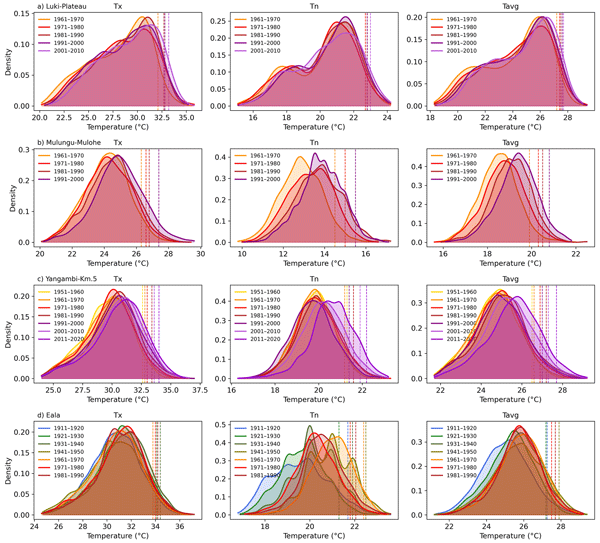
The Congo Basin is one of the least studied regions for climate change due to limited accessible data, despite large volumes of historical records stored on paper in archives. In this study, we digitised over 9000 sheets from 37 stations in the Democratic Republic of the Congo, producing more than one million daily weather observations. The results show clear warming since the 1960s, with more hot days and fewer cold days, highlighting the importance of data rescue in data-sparse regions.
Antoine Dille, Olivier Dewitte, Jente Broeckx, Koen Verbist, Andile Sindiso Dube, Jean Poesen, and Matthias Vanmaercke
Nat. Hazards Earth Syst. Sci., 26, 2561–2577, https://doi.org/10.5194/nhess-26-2561-2026, https://doi.org/10.5194/nhess-26-2561-2026, 2026
Short summary
Short summary
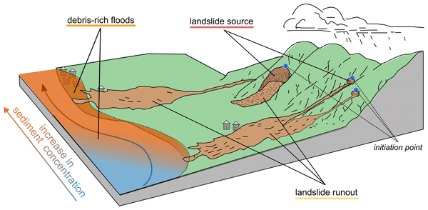
In mountain regions, intense rainfall can trigger thousands of landslides within hours. Yet, while most efforts focus on where landslides start, the worst impacts often occur far downstream because slope material can mix with large runoffs. Studying Cyclone Idai’s impacts in eastern Zimbabwe, we found that landslide sources explain only one-fifth of total population exposure, highlighting the need to consider the full landslide–flood continuum to better protect people and plan safer landscapes.
Eric Lutete Landu, Guy Ilombe Mawe, Elise Dujardin, Fils Makanzu Imwangana, Charles Bielders, Olivier Dewitte, Jean Poesen, Caroline Michellier, Aurélia Hubert, and Matthias Vanmaercke
EGUsphere, https://doi.org/10.5194/egusphere-2026-1774, https://doi.org/10.5194/egusphere-2026-1774, 2026
Short summary
Short summary
Urban gullies are a major problem in Kinshasa, caused by poor planning, fragile soils, and heavy rainfall. They destroy homes, disrupt services, and reduce land value, increasing poverty. A study of 802 households near 183 gullies and 12 brokers shows severe damage and high costs, with property losses estimated at 979 million dollars. Many people underestimate risks, and local solutions are often ineffective, highlighting the urgent need for better planning, prevention and coordinated action.

Jean-Claude Maki Mateso, Charles L. Bielders, Elise Monsieurs, Arthur Depicker, Benoît Smets, Théophile Tambala, Luc Bagalwa Mateso, and Olivier Dewitte
Nat. Hazards Earth Syst. Sci., 23, 643–666, https://doi.org/10.5194/nhess-23-643-2023, https://doi.org/10.5194/nhess-23-643-2023, 2023
Short summary
Short summary
This research highlights the importance of human activities on the occurrence of landslides and the need to consider this context when studying hillslope instability patterns in regions under anthropogenic pressure. Also, this study highlights the importance of considering the timing of landslides and hence the added value of using historical information for compiling an inventory.
Axel A. J. Deijns, Olivier Dewitte, Wim Thiery, Nicolas d'Oreye, Jean-Philippe Malet, and François Kervyn
Nat. Hazards Earth Syst. Sci., 22, 3679–3700, https://doi.org/10.5194/nhess-22-3679-2022, https://doi.org/10.5194/nhess-22-3679-2022, 2022
Short summary
Short summary
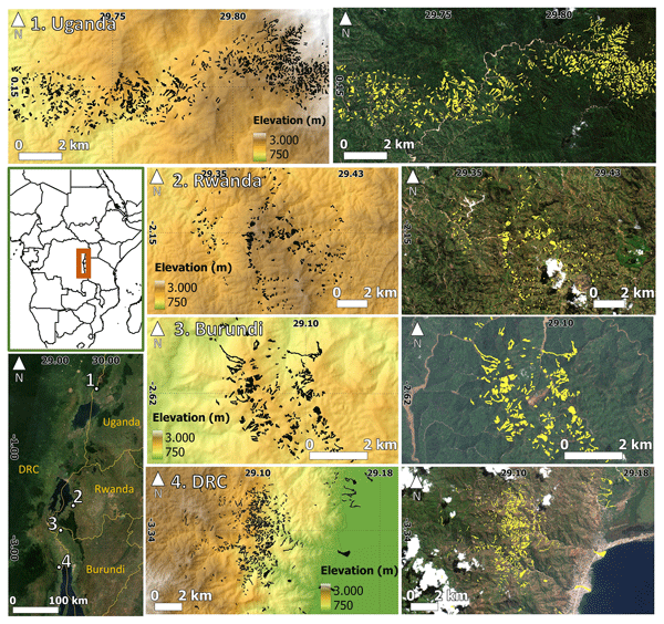
Landslides and flash floods are rainfall-induced processes that often co-occur and interact, generally very quickly. In mountainous cloud-covered environments, determining when these processes occur remains challenging. We propose a regional methodology using open-access satellite radar images that allow for the timing of landslide and flash floods events, in the contrasting landscapes of tropical Africa, with an accuracy of up to a few days. The methodology shows potential for transferability.
Cited articles
Acheson, E., De Sabbata, S., and Purves, R. S.: A quantitative analysis of global gazetteers: Patterns of coverage for common feature types, Comput. Environ. Urban, 64, 309–320, https://doi.org/10.1016/j.compenvurbsys.2017.03.007, 2017.
Allcott, H. and Gentzkow, M.: Social Media and Fake News in the 2016 Election, J. Econ. Perspect., 31, 211–236, https://doi.org/10.1257/jep.31.2.211, 2017.
Ankerst, M., Breunig, M. M., Kriegel, H.-P., and Sander, J.: OPTICS: ordering points to identify the clustering structure, SIGMOD Rec., 28, 49–60, https://doi.org/10.1145/304181.304187, 1999.
Avcıoğlu, A., Demir, O., and Görüm, T.: An automated approach for developing geohazard inventories using news: integrating natural language processing (NLP), machine learning, and mapping, Nat. Hazards Earth Syst. Sci., 25, 2421–2435, https://doi.org/10.5194/nhess-25-2421-2025, 2025.
Avvenuti, M., Cimino, M. G. C. A., Cresci, S., Marchetti, A., and Tesconi, M.: A framework for detecting unfolding emergencies using humans as sensors, SpringerPlus, 5, https://doi.org/10.1186/s40064-016-1674-y, 2016.
Bailon, H., Boersma, K., Orellana-Rodriguez, C., and Van Den Homberg, M.: Framing of disaster impact in online news media: a case study from Malawi on flood risk management, Front. Commun., 10, 1519357, https://doi.org/10.3389/fcomm.2025.1519357, 2025.
Battistini, A., Segoni, S., Manzo, G., Catani, F., and Casagli, N.: Web data mining for automatic inventory of geohazards at national scale, Appl. Geogr., 43, 147–158, https://doi.org/10.1016/j.apgeog.2013.06.012, 2013.
Berlemann, M. and Thomas, T.: The distance bias in natural disaster reporting – empirical evidence for the United States, Appl. Econ. Lett., 26, 1026–1032, https://doi.org/10.1080/13504851.2018.1528332, 2019.
Blomeier, E., Schmidt, S., and Resch, B.: Drowning in the Information Flood: Machine-Learning-Based Relevance Classification of Flood-Related Tweets for Disaster Management, Information, 15, 149, https://doi.org/10.3390/info15030149, 2024.
Borga, M., Anagnostou, E. N., Blöschl, G., and Creutin, J.-D.: Flash flood forecasting, warning and risk management: the HYDRATE project, Environ. Sci. Policy, 14, 834–844, https://doi.org/10.1016/j.envsci.2011.05.017, 2011.
Brown, T. B., Mann, B., Ryder, N., Subbiah, M., Kaplan, J., Dhariwal, P., Neelakantan, A., Shyam, P., Sastry, G., Askell, A., Agarwal, S., Herbert-Voss, A., Krueger, G., Henighan, T., Child, R., Ramesh, A., Ziegler, D. M., Wu, J., Winter, C., Hesse, C., Chen, M., Sigler, E., Litwin, M., Gray, S., Chess, B., Clark, J., Berner, C., McCandlish, S., Radford, A., Sutskever, I., and Amodei, D.: Language Models are Few-Shot Learners, arXiv [preprint], https://doi.org/10.48550/arXiv.2005.14165, 2020.
Burrows, K., Walters, R. J., Milledge, D., Spaans, K., and Densmore, A. L.: A New Method for Large-Scale Landslide Classification from Satellite Radar, Remote Sens.-Basel, 11, 237, https://doi.org/10.3390/rs11030237, 2019.
Calcaterra, D., Parise, M., and Palma, B.: Combining historical and geological data for the assessment of the landslide hazard: a case study from Campania, Italy, Nat. Hazards Earth Syst. Sci., 3, 3–16, https://doi.org/10.5194/nhess-3-3-2003, 2003.
Calvello, M. and Pecoraro, G.: FraneItalia: a catalog of recent Italian landslides, Geoenviron. Disasters, 5, 13, https://doi.org/10.1186/s40677-018-0105-5, 2018.
Casagli, N., Intrieri, E., Tofani, V., Gigli, G., and Raspini, F.: Landslide detection, monitoring and prediction with remote-sensing techniques, Nat. Rev. Earth Environ., 4, 51–64, https://doi.org/10.1038/s43017-022-00373-x, 2023.
Cervone, G., Sava, E., Huang, Q., Schnebele, E., Harrison, J., and Waters, N.: Using Twitter for tasking remote-sensing data collection and damage assessment: 2013 Boulder flood case study, Int. J. Remote Sens., 37, 100–124, https://doi.org/10.1080/01431161.2015.1117684, 2016.
Chan, B., Möler, T., Pietsch, M., and Soni, T.: deepset/roberta-base-squad2, https://huggingface.co/deepset/roberta-base-squad2 (last access: 22 May 2025), 2020.
Conneau, A., Khandelwal, K., Goyal, N., Chaudhary, V., Wenzek, G., Guzmán, F., Grave, E., Ott, M., Zettlemoyer, L., and Stoyanov, V.: Unsupervised Cross-lingual Representation Learning at Scale, arXiv [preprint], https://doi.org/10.48550/arXiv.1911.02116, 2019.
De Bruijn, J. A., De Moel, H., Jongman, B., De Ruiter, M. C., Wagemaker, J., and Aerts, J. C. J. H.: A global database of historic and real-time flood events based on social media, Sci. Data, 6, 311, https://doi.org/10.1038/s41597-019-0326-9, 2019.
Deijns, A. A. J., Dewitte, O., Thiery, W., d'Oreye, N., Malet, J.-P., and Kervyn, F.: Timing landslide and flash flood events from SAR satellite: a regionally applicable methodology illustrated in African cloud-covered tropical environments, Nat. Hazards Earth Syst. Sci., 22, 3679–3700, https://doi.org/10.5194/nhess-22-3679-2022, 2022.
Deijns, A. A. J., Michéa, D., Déprez, A., Malet, J.-P., Kervyn, F., Thiery, W., and Dewitte, O.: A semi-supervised multi-temporal landslide and flash flood event detection methodology for unexplored regions using massive satellite image time series, ISPRS J. Photogramm., 215, 400–418, https://doi.org/10.1016/j.isprsjprs.2024.07.010, 2024.
Delforge, D., Wathelet, V., Below, R., Sofia, C. L., Tonnelier, M., Van Loenhout, J. A. F., and Speybroeck, N.: EM-DAT: the Emergency Events Database, Int. J. Disast. Risk Re., 124, 105509, https://doi.org/10.1016/j.ijdrr.2025.105509, 2025.
Depicker, A., Jacobs, L., Delvaux, D., Havenith, H.-B., Maki Mateso, J.-C., Govers, G., and Dewitte, O.: The added value of a regional landslide susceptibility assessment: The western branch of the East African Rift, Geomorphology, 353, 106886, https://doi.org/10.1016/j.geomorph.2019.106886, 2020.
Depicker, A., Jacobs, L., Mboga, N., Smets, B., Van Rompaey, A., Lennert, M., Wolff, E., Kervyn, F., Michellier, C., Dewitte, O., and Govers, G.: Historical dynamics of landslide risk from population and forest-cover changes in the Kivu Rift, Nat. Sustain., 4, 965–974, https://doi.org/10.1038/s41893-021-00757-9, 2021a.
Depicker, A., Govers, G., Jacobs, L., Campforts, B., Uwihirwe, J., and Dewitte, O.: Interactions between deforestation, landscape rejuvenation, and shallow landslides in the North Tanganyika–Kivu rift region, Africa, Earth Surf. Dynam., 9, 445–462, https://doi.org/10.5194/esurf-9-445-2021, 2021b.
Devlin, J., Chang, M.-W., Lee, K., and Toutanova, K.: BERT: Pre-training of Deep Bidirectional Transformers for Language Understanding, arXiv [preprint], https://doi.org/10.48550/arXiv.1810.04805, 2019.
Devoli, G., Morales, A., and Høeg, K.: Historical landslides in Nicaragua – collection and analysis of data, Landslides, 4, 5–18, https://doi.org/10.1007/s10346-006-0048-x, 2007.
Domínguez Cuesta, M. J., Jiménez Sánchez, M., and Rodríguez García, A.: Press archives as temporal records of landslides in the North of Spain: relationships between rainfall and instability slope events, Geomorphology, 30, 125–132, https://doi.org/10.1016/S0169-555X(99)00049-5, 1999.
Eisensee, T. and Stromberg, D.: News Droughts, News Floods, and U. S. Disaster Relief, Q. J. Econ., 122, 693–728, https://doi.org/10.1162/qjec.122.2.693, 2007.
El Ouadi, A. and Beskow, D.: Comparison of Common Crawl News & GDELT, in: 2024 IEEE International Systems Conference (SysCon), 2024 IEEE International Systems Conference (SysCon), 1–3, https://doi.org/10.1109/SysCon61195.2024.10553540, 2024.
Emberson, R., Kirschbaum, D., and Stanley, T.: New global characterisation of landslide exposure, Nat. Hazards Earth Syst. Sci., 20, 3413–3424, https://doi.org/10.5194/nhess-20-3413-2020, 2020.
Ester, M., Kriegel, H.-P., Sander, J., and Xu, X.: A density-based algorithm for discovering clusters in large spatial databases with noise, in: Proceedings of the Second International Conference on Knowledge Discovery and Data Mining, Portland, Oregon, 226–231, 1996.
European Commission. Joint Research Centre.: GHSL data package 2023, Publications Office, LU, https://doi.org/10.2760/098587, 2023.
Fan, C., Wu, F., and Mostafavi, A.: A Hybrid Machine Learning Pipeline for Automated Mapping of Events and Locations From Social Media in Disasters, IEEE Access, 8, 10478–10490, https://doi.org/10.1109/ACCESS.2020.2965550, 2020.
Ferrer, J. V., Samprogna Mohor, G., Dewitte, O., Pánek, T., Reyes-Carmona, C., Handwerger, A. L., Hürlimann, M., Köhler, L., Teshebaeva, K., Thieken, A. H., Tsou, C., Urgilez Vinueza, A., Demurtas, V., Zhang, Y., Zhao, C., Marwan, N., Kurths, J., and Korup, O.: Human Settlement Pressure Drives Slow-Moving Landslide Exposure, Earth's Future, 12, e2024EF004830, https://doi.org/10.1029/2024EF004830, 2024.
Fetzer, T. and Garg, P.: Uneven patterns of cross-border media coverage following natural disasters, Nat. Hum. Behav., https://doi.org/10.1038/s41562-026-02512-6, 2026.
Franceschini, R., Rosi, A., Catani, F., and Casagli, N.: Exploring a landslide inventory created by automated web data mining: the case of Italy, Landslides, 19, 841–853, https://doi.org/10.1007/s10346-021-01799-y, 2022.
Franceschini, R., Rosi, A., Catani, F., and Casagli, N.: Detecting information from Twitter on landslide hazards in Italy using deep learning models, Geoenviron. Disasters, 11, 22, https://doi.org/10.1186/s40677-024-00279-4, 2024.
Froude, M. J. and Petley, D. N.: Global fatal landslide occurrence from 2004 to 2016, Nat. Hazards Earth Syst. Sci., 18, 2161–2181, https://doi.org/10.5194/nhess-18-2161-2018, 2018.
Fu, S., Lyu, H., Wang, Z., Hao, X., and Zhang, C.: Extracting historical flood locations from news media data by the named entity recognition (NER) model to assess urban flood susceptibility, J. Hydrol., 612, 128312, https://doi.org/10.1016/j.jhydrol.2022.128312, 2022.
Gall, M., Borden, K. A., and Cutter, S. L.: When Do Losses Count?: Six Fallacies of Natural Hazards Loss Data, B. Am. Meteorol. Soc., 90, 799–810, https://doi.org/10.1175/2008BAMS2721.1, 2009.
Ghosh, S., Maji, S., and Desarkar, M. S.: GNoM: Graph Neural Network Enhanced Language Models for Disaster Related Multilingual Text Classification, in: 14th ACM Web Science Conference 2022, WebSci '22: 14th ACM Web Science Conference 2022, 55–65, https://doi.org/10.1145/3501247.3531561, 2022.
Gill, J. C. and Malamud, B. D.: Reviewing and visualizing the interactions of natural hazards: Interactions of Natural Hazards, Rev. Geophys., 52, 680–722, https://doi.org/10.1002/2013RG000445, 2014.
Gómez, D., García, E. F., and Aristizábal, E.: Spatial and temporal landslide distributions using global and open landslide databases, Nat. Hazards, 117, 25–55, https://doi.org/10.1007/s11069-023-05848-8, 2023.
Gourley, J. J., Hong, Y., Flamig, Z. L., Arthur, A., Clark, R., Calianno, M., Ruin, I., Ortel, T., Wieczorek, M. E., Kirstetter, P.-E., Clark, E., and Krajewski, W. F.: A Unified Flash Flood Database across the United States, B. Am. Meteorol. Soc., 94, 799–805, https://doi.org/10.1175/bams-d-12-00198.1, 2013.
Graham, M. and De Sabbata, S.: Mapping information wealth and poverty: the geography of gazetteers, Environ. Plann. A, 47, 1254–1264, https://doi.org/10.1177/0308518X15594899, 2015.
Grilli, S. T., Tappin, D. R., Carey, S., Watt, S. F. L., Ward, S. N., Grilli, A. R., Engwell, S. L., Zhang, C., Kirby, J. T., Schambach, L., and Muin, M.: Modelling of the tsunami from the 22 December 2018 lateral collapse of Anak Krakatau volcano in the Sunda Straits, Indonesia, Sci. Rep.-UK, 9, https://doi.org/10.1038/s41598-019-48327-6, 2019.
Guerreiro, N. M., Alves, D. M., Waldendorf, J., Haddow, B., Birch, A., Colombo, P., and Martins, A. F. T.: Hallucinations in Large Multilingual Translation Models, Transactions of the Association for Computational Linguistics, 11, 1500–1517, https://doi.org/10.1162/tacl_a_00615, 2023.
Guzzetti, F., Cardinali, M., and Reichenbach, P.: The AVI project: A bibliographical and archive inventory of landslides and floods in Italy, Environ. Manage., 18, 623–633, https://doi.org/10.1007/BF02400865, 1994.
Guzzetti, F., Mondini, A. C., Cardinali, M., Fiorucci, F., Santangelo, M., and Chang, K.-T.: Landslide inventory maps: New tools for an old problem, Earth-Sci. Rev., 112, 42–66, https://doi.org/10.1016/j.earscirev.2012.02.001, 2012.
Guzzetti, F., Gariano, S. L., Peruccacci, S., Brunetti, M. T., Marchesini, I., Rossi, M., and Melillo, M.: Geographical landslide early warning systems, Earth-Sci. Rev., 200, 102973, https://doi.org/10.1016/j.earscirev.2019.102973, 2020.
Harris, A. J. L. and Villeneuve, N.: Newspaper reporting of the April 2007 eruption of Piton de la Fournaise part 1: useful information or tabloid sensationalism?, J. Appl. Volcanol., 7, 4, https://doi.org/10.1186/s13617-018-0073-1, 2018.
Hungr, O., Leroueil, S., and Picarelli, L.: The Varnes classification of landslide types, an update, Landslides, 11, 167–194, https://doi.org/10.1007/s10346-013-0436-y, 2014.
Ibsen, M.-L. and Brunsden, D.: The nature, use and problems of historical archives for the temporal occurrence of landslides, with specific reference to the south coast of Britain, Ventnor, Isle of Wight, Geomorphology, 15, 241–258, https://doi.org/10.1016/0169-555X(95)00073-E, 1996.
IPCC: Climate Change 2022 – Impacts, Adaptation and Vulnerability: Working Group II Contribution to the Sixth Assessment Report of the Intergovernmental Panel on Climate Change, 1st edn., Cambridge University Press, https://doi.org/10.1017/9781009325844, 2022.
Jacobs, L., Kabaseke, C., Bwambale, B., Katutu, R., Dewitte, O., Mertens, K., Maes, J., and Kervyn, M.: The geo-observer network: A proof of concept on participatory sensing of disasters in a remote setting, Sci. Total Environ., 670, 245–261, https://doi.org/10.1016/j.scitotenv.2019.03.177, 2019.
Ji, Z., Lee, N., Frieske, R., Yu, T., Su, D., Xu, Y., Ishii, E., Bang, Y. J., Madotto, A., and Fung, P.: Survey of Hallucination in Natural Language Generation, ACM Comput. Surv., 55, 1–38, https://doi.org/10.1145/3571730, 2023.
Joshi, P., Santy, S., Budhiraja, A., Bali, K., and Choudhury, M.: The State and Fate of Linguistic Diversity and Inclusion in the NLP World, arXiv [preprint], https://doi.org/10.48550/arXiv.2004.09095, 2020.
Joye, S.: The hierarchy of global suffering: A critical discourse analysis of television news reporting on foreign natural disasters, Journal of International Communication, 15, 45–61, https://doi.org/10.1080/13216597.2009.9674750, 2009.
Kanyiginya, V., Twongyirwe, R., Kagoro-Rugunda, G., Mubiru, D., Sekajugo, J., Mutyebere, R., Deijns, A. A. J., Kervyn, M., and Dewitte, O.: Inventories of natural hazards in under-reported regions: a multi-method insight from a tropical mountainous landscape, African Geographical Review, 43, 827–846, https://doi.org/10.1080/19376812.2023.2280589, 2024.
Kirschbaum, D. and Stanley, T.: Satellite-Based Assessment of Rainfall-Triggered Landslide Hazard for Situational Awareness, Earth's Future, 6, 505–523, https://doi.org/10.1002/2017EF000715, 2018.
Kirschbaum, D. B., Adler, R., Hong, Y., Hill, S., and Lerner-Lam, A.: A global landslide catalog for hazard applications: method, results, and limitations, Nat. Hazards, 52, 561–575, https://doi.org/10.1007/s11069-009-9401-4, 2010.
Kirschbaum, D., Stanley, T., and Zhou, Y.: Spatial and temporal analysis of a global landslide catalog, Geomorphology, 249, 4–15, https://doi.org/10.1016/j.geomorph.2015.03.016, 2015.
Kreuzer, T. M. and Damm, B.: Automated digital data acquisition for landslide inventories, Landslides, 17, 2205–2215, https://doi.org/10.1007/s10346-020-01431-5, 2020.
Kwak, H. and An, J.: A First Look at Global News Coverage of Disasters by Using the GDELT Dataset, in: Social Informatics, vol. 8851, edited by: Aiello, L. M. and McFarland, D., Springer International Publishing, Cham, 300–308, https://doi.org/10.1007/978-3-319-13734-6_22, 2014.
Lai, H., Han, S., Li, Y., Yu, Z., and Guo, Z.: Evaluating the Translation Performance of Multilingual Large Language Models: A Case Study on Southeast Asian Languages, in: Communications in Computer and Information Science, Springer Nature Singapore, Singapore, 27–47, https://doi.org/10.1007/978-981-96-2292-4_3, 2025.
Laurer, M., Van Atteveldt, W., Casas, A., and Welbers, K.: Less Annotating, More Classifying: Addressing the Data Scarcity Issue of Supervised Machine Learning with Deep Transfer Learning and BERT-NLI, Polit. Anal., 32, 84–100, https://doi.org/10.1017/pan.2023.20, 2024.
Lehner, B. and Grill, G.: Global river hydrography and network routing: baseline data and new approaches to study the world's large river systems, Hydrol. Process., 27, 2171–2186, https://doi.org/10.1002/hyp.9740, 2013.
Li, F.-F., Fergus, R., and Perona, P.: One-shot learning of object categories, IEEE T. Pattern Anal., 28, 594–611, https://doi.org/10.1109/TPAMI.2006.79, 2006.
Li, L., Bensi, M., Cui, Q., Baecher, G. B., and Huang, Y.: Social media crowdsourcing for rapid damage assessment following a sudden-onset natural hazard event, Int. J. Inform. Manage., 60, 102378, https://doi.org/10.1016/j.ijinfomgt.2021.102378, 2021.
Li, N., Thiery, W., Zahra, S., Madruga De Brito, M., Worou, K., Kurfali, M., Lampe, S., Munoz, P., Flynn, C., Trigoso, C., Nivre, J., Zscheischler, J., and Messori, G.: Wikimpacts 1.0: A new global climate impact database based on automated information extraction from Wikipedia, https://doi.org/10.5194/egusphere-egu25-8954, 2025.
MacEachren, A. M., Jaiswal, A., Robinson, A. C., Pezanowski, S., Savelyev, A., Mitra, P., Zhang, X., and Blanford, J.: SensePlace2: GeoTwitter analytics support for situational awareness, in: 2011 IEEE Conference on Visual Analytics Science and Technology (VAST), 2011 IEEE Conference on Visual Analytics Science and Technology (VAST), 181–190, https://doi.org/10.1109/VAST.2011.6102456, 2011.
Madruga de Brito, M., Sodoge, J., Kreibich, H., and Kuhlicke, C.: Comprehensive Assessment of Flood Socioeconomic Impacts Through Text-Mining, Water Resour. Res., 61, e2024WR037813, https://doi.org/10.1029/2024WR037813, 2025a.
Madruga de Brito, M., Rotaru, A. M., Wang, J., Gesualdo, G., Hasbini, L., Severino, L., and Nunes Carvalho, T. M.: Developing a multi-hazard impact and response dataset for the Global South, EGU General Assembly 2025, Vienna, Austria, 27 Apr–2 May 2025, EGU25-17817, https://doi.org/10.5194/egusphere-egu25-17817, 2025b.
Maes, J., Kervyn, M., De Hontheim, A., Dewitte, O., Jacobs, L., Mertens, K., Vanmaercke, M., Vranken, L., and Poesen, J.: Landslide risk reduction measures: A review of practices and challenges for the tropics, Prog. Phys. Geogr., 41, 191–221, https://doi.org/10.1177/0309133316689344, 2017.
Mawe, G. I., Landu, E. L., Dujardin, E., Imwangana, F. M., Bielders, C., Hubert, A., Michellier, C., Nzolang, C., Poesen, J., Dewitte, O., and Vanmaercke, M.: Mapping urban gullies in the Democratic Republic of the Congo, Nature, 644, 952–959, https://doi.org/10.1038/s41586-025-09371-7, 2025.
Mayo, R., Zlydenko, O., Bootbool, M., Fronman, S., Gilon, O., Hassidim, A., Kratzert, F., Loike, G., Matias, Y., Nakar, Y., Nearing, G., Sayag, R., Sicherman, A., Zemach, I., and Cohen, D.: Groundsource: A Dataset of Flood Events from News, https://doi.org/10.31223/X5RR2K, 10 March 2026, 2026.
Merz, B., Blöschl, G., Vorogushyn, S., Dottori, F., Aerts, J. C. J. H., Bates, P., Bertola, M., Kemter, M., Kreibich, H., Lall, U., and Macdonald, E.: Causes, impacts and patterns of disastrous river floods, Nat. Rev. Earth Environ., 2, 592–609, https://doi.org/10.1038/s43017-021-00195-3, 2021.
Metreau, E., Elizabeth, K., and Eapen, S.: Understanding country income: World Bank Group income classifications for FY26 (1 July 2025–June, 2026), https://blogs.worldbank.org/en/opendata/understanding-country-income–world-bank-group-income-classifica#one (last access: 8 July 2026), 2025.
Middleton, S. E. and Krivcovs, V.: Geoparsing and Geosemantics for Social Media: Spatiotemporal Grounding of Content Propagating Rumors to Support Trust and Veracity Analysis during Breaking News, ACM T. Inform. Syst., 34, 1–26, https://doi.org/10.1145/2842604, 2016.
Middleton, S. E., Middleton, L., and Modafferi, S.: Real-Time Crisis Mapping of Natural Disasters Using Social Media, IEEE Intell. Syst., 29, 9–17, https://doi.org/10.1109/MIS.2013.126, 2014.
Middleton, S. E., Kordopatis-Zilos, G., Papadopoulos, S., and Kompatsiaris, Y.: Location Extraction from Social Media: Geoparsing, Location Disambiguation, and Geotagging, ACM T. Inform. Syst., 36, 1–27, https://doi.org/10.1145/3202662, 2018.
Monsieurs, E., Jacobs, L., Michellier, C., Basimike Tchangaboba, J., Ganza, G. B., Kervyn, F., Maki Mateso, J.-C., Mugaruka Bibentyo, T., Kalikone Buzera, C., Nahimana, L., Ndayisenga, A., Nkurunziza, P., Thiery, W., Demoulin, A., Kervyn, M., and Dewitte, O.: Landslide inventory for hazard assessment in a data-poor context: a regional-scale approach in a tropical African environment, Landslides, 15, 2195–2209, https://doi.org/10.1007/s10346-018-1008-y, 2018.
Muñoz-Torrero Manchado, A., Allen, S., Ballesteros-Cánovas, J. A., Dhakal, A., Dhital, M. R., and Stoffel, M.: Three decades of landslide activity in western Nepal: new insights into trends and climate drivers, Landslides, 18, 2001–2015, https://doi.org/10.1007/s10346-021-01632-6, 2021.
Murthy, D. and Longwell, S. A.: Twitter and disasters: The uses of Twitter during the 2010 Pakistan floods, Information, Communication & Society, 16, 837–855, https://doi.org/10.1080/1369118X.2012.696123, 2013.
Nsabimana, J., Henry, S., Ndayisenga, A., Kubwimana, D., Dewitte, O., Kervyn, F., and Michellier, C.: Geo-Hydrological Hazard Impacts, Vulnerability and Perception in Bujumbura (Burundi): A High-Resolution Field-Based Assessment in a Sprawling City, Land, 12, 1876, https://doi.org/10.3390/land12101876, 2023.
Nunes Carvalho, T. M., Zscheischler, J., Kuhlicke, C., and Madruga de Brito, M.: A global database of natural hazards impacts reported in the scientific literature, EGU General Assembly 2024, Vienna, Austria, 14–19 April 2024, EGU24-19940, https://doi.org/10.5194/egusphere-egu24-19940, 2024.
Ofli, F., Imran, M., Qazi, U., Roch, J., Pennington, C., Banks, V., and Bossu, R.: Landslide detection in real-time social media image streams, Neural Comput. Appl., 35, 17809–17819, https://doi.org/10.1007/s00521-023-08648-0, 2023.
OpenStreetMap contributors: Planet dump retrieved from https://planet.osm.org (last access: 2 November 2025), 2017.
Ou-Yang, L.: Newspaper3k: Article scraping & curation, GitHub repository [code], https://github.com/codelucas/newspaper (last access: 5 September 2025), 2014
Owuor, I., Hochmair, H. H., and Cvetojevic, S.: Tracking Hurricane Dorian in GDELT and Twitter, AGILE GIScience Ser., 1, 1–18, https://doi.org/10.5194/agile-giss-1-19-2020, 2020.
Ozturk, U., Bozzolan, E., Holcombe, E. A., Shukla, R., Pianosi, F., and Wagener, T.: How climate change and unplanned urban sprawl bring more landslides, Nature, 608, 262–265, https://doi.org/10.1038/d41586-022-02141-9, 2022.
Poblete, B., Guzman, J., Maldonado, J., and Tobar, F.: Robust Detection of Extreme Events Using Twitter: Worldwide Earthquake Monitoring, IEEE T. Multimedia, 20, 2551–2561, https://doi.org/10.1109/TMM.2018.2855107, 2018.
Porter, J. J. and Evans, G.: Unreported world: A critical analysis of UK newspaper coverage of post-disaster events, Geogr. J., 186, 327–338, https://doi.org/10.1111/geoj.12353, 2020.
Qian, F., Gong, C., Sharma, K., and Liu, Y.: Neural User Response Generator: Fake News Detection with Collective User Intelligence, in: Proceedings of the Twenty-Seventh International Joint Conference on Artificial Intelligence, Twenty-Seventh International Joint Conference on Artificial Intelligence IJCAI-18, 13–19 July 2018, 3834–3840, https://doi.org/10.24963/ijcai.2018/533, 2018.
Radford, A., Narasimhan, K., Salimans, T., and Sutskever, I.: Improving language understanding by generative pre-training, OpenAI, 12 pp, https://cdn.openai.com/research-covers/language-unsupervised/language_understanding_paper.pdf (last access: 29 October 2025), 2018.
Robinson, N. R., Ogayo, P., Mortensen, D. R., and Neubig, G.: ChatGPT MT: Competitive for High- (but not Low-) Resource Languages, arXiv [preprint], https://doi.org/10.48550/arXiv.2309.07423, 2023.
Rodrigo-Ginés, F.-J., Carrillo-de-Albornoz, J., and Plaza, L.: A systematic review on media bias detection: What is media bias, how it is expressed, and how to detect it, Expert Syst. Appl., 237, 121641, https://doi.org/10.1016/j.eswa.2023.121641, 2024.
Rodrigues, S. G., Silva, M. M., and Alencar, M. H.: A proposal for an approach to mapping susceptibility to landslides using natural language processing and machine learning, Landslides, 18, 2515–2529, https://doi.org/10.1007/s10346-021-01643-3, 2021.
Rogers, A., Kovaleva, O., and Rumshisky, A.: A Primer in BERTology: What We Know About How BERT Works, Transactions of the Association for Computational Linguistics, 8, 842–866, https://doi.org/10.1162/tacl_a_00349, 2020.
Rogers, A., Gardner, M., and Augenstein, I.: QA Dataset Explosion: A Taxonomy of NLP Resources for Question Answering and Reading Comprehension, ACM Comput. Surv., 55, 1–45, https://doi.org/10.1145/3560260, 2023.
Rossi, C., Acerbo, F. S., Ylinen, K., Juga, I., Nurmi, P., Bosca, A., Tarasconi, F., Cristoforetti, M., and Alikadic, A.: Early detection and information extraction for weather-induced floods using social media streams, Int. J. Disast. Risk Re., 30, 145–157, https://doi.org/10.1016/j.ijdrr.2018.03.002, 2018.
Rossi, M., Witt, A., Guzzetti, F., Malamud, B. D., and Peruccacci, S.: Analysis of historical landslide time series in the Emilia-Romagna region, northern Italy, Earth Surf. Proc. Land., 35, 1123–1137, https://doi.org/10.1002/esp.1858, 2010.
Sanh, V., Debut, L., Chaumond, J., and Wolf, T.: DistilBERT, a distilled version of BERT: smaller, faster, cheaper and lighter, arXiv [preprint], https://doi.org/10.48550/arXiv.1910.01108, 2019.
Schlögl, M., Fuchs, S., Scheidl, C., and Heiser, M.: Trends in torrential flooding in the Austrian Alps: A combination of climate change, exposure dynamics, and mitigation measures, Climate Risk Management, 32, 100294, https://doi.org/10.1016/j.crm.2021.100294, 2021.
Sekajugo, J., Kagoro-Rugunda, G., Mutyebere, R., Kabaseke, C., Namara, E., Dewitte, O., Kervyn, M., and Jacobs, L.: Can citizen scientists provide a reliable geo-hydrological hazard inventory? An analysis of biases, sensitivity and precision for the Rwenzori Mountains, Uganda, Environ. Res. Lett., 17, 045011, https://doi.org/10.1088/1748-9326/ac5bb5, 2022.
Shabir, W., Amirov, E., and Sadurski, A.: dateparser: Python parser for human readable dates (1.2.2), https://github.com/scrapinghub/dateparser (last access: 15 October 2025), 2025.
Sirén-Heikel, S., Leppänen, L., Lindén, C.-G., and Bäck, A.: Unboxing news automation: Exploring imagined affordances of automation in news journalism, Nord. J. Med. Stud., 1, 47–66, https://doi.org/10.2478/njms-2019-0004, 2019.
Smith, A., Bates, P. D., Wing, O., Sampson, C., Quinn, N., and Neal, J.: New estimates of flood exposure in developing countries using high-resolution population data, Nat. Commun., 10, https://doi.org/10.1038/s41467-019-09282-y, 2019.
Sodoge, J., Kuhlicke, C., and De Brito, M. M.: Automatized spatio-temporal detection of drought impacts from newspaper articles using natural language processing and machine learning, Weather and Climate Extremes, 41, 100574, https://doi.org/10.1016/j.wace.2023.100574, 2023.
Solman, P. and Henderson, L.: Flood disasters in the United Kingdom and India: A critical discourse analysis of media reporting, Journalism, 20, 1648–1664, https://doi.org/10.1177/1464884918762363, 2019.
Stanley, T. and Kirschbaum, D. B.: A heuristic approach to global landslide susceptibility mapping, Nat. Hazards, 87, 145–164, https://doi.org/10.1007/s11069-017-2757-y, 2017.
Stein, L., Mukkavilli, S. K., Pfitzmann, B. M., Staar, P. W. J., Ozturk, U., Berrospi, C., Brunschwiler, T., and Wagener, T.: Wealth Over Woe: Global Biases in Hydro-Hazard Research, Earth's Future, 12, e2024EF004590, https://doi.org/10.1029/2024EF004590, 2024.
Sun, A. Y. and Scanlon, B. R.: How can Big Data and machine learning benefit environment and water management: a survey of methods, applications, and future directions, Environ. Res. Lett., 14, 073001, https://doi.org/10.1088/1748-9326/ab1b7d, 2019.
Tang, Y., Tran, C., Li, X., Chen, P.-J., Goyal, N., Chaudhary, V., Gu, J., and Fan, A.: Multilingual Translation with Extensible Multilingual Pretraining and Finetuning, arXiv [preprint], https://doi.org/10.48550/arXiv.2008.00401, 2020.
Taylor, F. E., Malamud, B. D., Freeborough, K., and Demeritt, D.: Enriching Great Britain's National Landslide Database by searching newspaper archives, Geomorphology, 249, 52–68, https://doi.org/10.1016/j.geomorph.2015.05.019, 2015.
Tellman, B., Sullivan, J. A., Kuhn, C., Kettner, A. J., Doyle, C. S., Brakenridge, G. R., Erickson, T. A., and Slayback, D. A.: Satellite imaging reveals increased proportion of population exposed to floods, Nature, 596, 80–86, https://doi.org/10.1038/s41586-021-03695-w, 2021.
Tiedemann, J., Aulamo, M., Bakshandaeva, D., Boggia, M., Grönroos, S.-A., Nieminen, T., Raganato, A., Scherrer, Y., Vázquez, R., and Virpioja, S.: Democratizing neural machine translation with OPUS-MT, Lang. Resour. Eval., 58, 713–755, https://doi.org/10.1007/s10579-023-09704-w, 2024.
Tounsi, A. and Temimi, M.: A systematic review of natural language processing applications for hydrometeorological hazards assessment, Nat. Hazards, 116, 2819–2870, https://doi.org/10.1007/s11069-023-05842-0, 2023.
Tradowsky, J. S., Philip, S. Y., Kreienkamp, F., Kew, S. F., Lorenz, P., Arrighi, J., Bettmann, T., Caluwaerts, S., Chan, S. C., De Cruz, L., De Vries, H., Demuth, N., Ferrone, A., Fischer, E. M., Fowler, H. J., Goergen, K., Heinrich, D., Henrichs, Y., Kaspar, F., Lenderink, G., Nilson, E., Otto, F. E. L., Ragone, F., Seneviratne, S. I., Singh, R. K., Skålevåg, A., Termonia, P., Thalheimer, L., Van Aalst, M., Van Den Bergh, J., Van De Vyver, H., Vannitsem, S., Van Oldenborgh, G. J., Van Schaeybroeck, B., Vautard, R., Vonk, D., and Wanders, N.: Attribution of the heavy rainfall events leading to severe flooding in Western Europe during July 2021, Climatic Change, 176, 90, https://doi.org/10.1007/s10584-023-03502-7, 2023.
Tunstall, L., Reimers, N., Jo, U. E. S., Bates, L., Korat, D., Wasserblat, M., and Pereg, O.: Efficient Few-Shot Learning Without Prompts, arXiv [preprint], https://doi.org/10.48550/arXiv.2209.11055, 2022.
UNDRR: Sendai Framework for Disaster Risk Reduction 2015–2030, https://www.undrr.org/publication/sendai-framework-disaster-risk-reduction-2015-2030 (last access: 29 July 2025), 2015.
United Nations Office for Disaster Risk Reduction: The Sendai Framework Terminology on Disaster Risk Reduction, https://www.undrr.org/terminology/hazardous-event (last access: 14 July 2025), 2017.
Valenzuela, P., Domínguez-Cuesta, M. J., Mora García, M. A., and Jiménez-Sánchez, M.: A spatio-temporal landslide inventory for the NW of Spain: BAPA database, Geomorphology, 293, 11–23, https://doi.org/10.1016/j.geomorph.2017.05.010, 2017.
Valero, A. T., Montes, M., Pineda Villaseñor, G., and Pineda Villaseñor, L.: Using Machine Learning for Extracting Information from Natural Disaster News Reports, Computación y Sistemas, 13, 33–44, 2009.
Valkenborg, B., Dewitte, O., and Smets, B.: HazMiner dataset (v2), Zenodo [data set], https://doi.org/10.5281/zenodo.21965363, 2026a.
Valkenborg, B., Dewitte, O., and Smets, B.: HazMiner code (v2), Zenodo [code], https://doi.org/10.5281/zenodo.21965339, 2026b.
Valkenborg, B., Dewitte, O., and Smets, B.: all-MiniLM-L12-v2_HazMiner_nonevents, HuggingFace Hub [code], https://doi.org/10.57967/HF/9762, 2026c.
Van Den Eeckhaut, M. and Hervás, J.: State of the art of national landslide databases in Europe and their potential for assessing landslide susceptibility, hazard and risk, Geomorphology, 139–140, 545–558, https://doi.org/10.1016/j.geomorph.2011.12.006, 2012.
Vaswani, A., Shazeer, N., Parmar, N., Uszkoreit, J., Jones, L., Gomez, A. N., Kaiser, L., and Polosukhin, I.: Attention Is All You Need, arXiv [preprint], https://doi.org/10.48550/arXiv.1706.03762, 2017.
Vogler, D., Udris, L., and Eisenegger, M.: Measuring Media Content Concentration at a Large Scale Using Automated Text Comparisons, Journalism Stud., 21, 1459–1478, https://doi.org/10.1080/1461670X.2020.1761865, 2020.
Walter, D., Sheafer, T., Nir, L., and Shenhav, S.: Not All Countries Are Created Equal: Foreign Countries Prevalence in U. S. News and Entertainment Media, Mass Commun. Soc., 19, 522–541, https://doi.org/10.1080/15205436.2016.1170853, 2016.
Wang, W., Wei, F., Dong, L., Bao, H., Yang, N., and Zhou, M.: MiniLM: Deep Self-Attention Distillation for Task-Agnostic Compression of Pre-Trained Transformers, arXiv [preprint], https://doi.org/10.48550/arXiv.2002.10957, 2020.
Wang, Z., Ye, X., and Tsou, M.-H.: Spatial, temporal, and content analysis of Twitter for wildfire hazards, Nat. Hazards, 83, 523–540, https://doi.org/10.1007/s11069-016-2329-6, 2016.
Ward, P. J., Blauhut, V., Bloemendaal, N., Daniell, J. E., de Ruiter, M. C., Duncan, M. J., Emberson, R., Jenkins, S. F., Kirschbaum, D., Kunz, M., Mohr, S., Muis, S., Riddell, G. A., Schäfer, A., Stanley, T., Veldkamp, T. I. E., and Winsemius, H. C.: Review article: Natural hazard risk assessments at the global scale, Nat. Hazards Earth Syst. Sci., 20, 1069–1096, https://doi.org/10.5194/nhess-20-1069-2020, 2020.
Wei, J., Wang, X., Schuurmans, D., Bosma, M., Ichter, B., Xia, F., Chi, E., Le, Q. V., and Zhou, D.: Chain-Of-Thought Prompting Elicits Reasoning in Large Language Models, in: Advances in Neural Information Processing Systems 35, Adv. Neural Info. Process. Syst. 35, 24824–24837, https://doi.org/10.52202/068431-1800, 2022.
Wei, J., Tay, Y., Bommasani, R., Raffel, C., Zoph, B., Borgeaud, S., Yogatama, D., Bosma, M., Zhou, D., Metzler, D., Chi, E. H., Hashimoto, T., Vinyals, O., Liang, P., Dean, J., and Fedus, W.: Emergent Abilities of Large Language Models, arXiv [preprint], https://doi.org/10.48550/arXiv.2206.07682, 2022b.
Wiegmann, M., Kersten, J., Senaratne, H., Potthast, M., Klan, F., and Stein, B.: Opportunities and risks of disaster data from social media: a systematic review of incident information, Nat. Hazards Earth Syst. Sci., 21, 1431–1444, https://doi.org/10.5194/nhess-21-1431-2021, 2021.
Yagoub, M. M., Alsereidi, A. A., Mohamed, E. A., Periyasamy, P., Alameri, R., Aldarmaki, S., and Alhashmi, Y.: Newspapers as a validation proxy for GIS modeling in Fujairah, United Arab Emirates: identifying flood-prone areas, Nat. Hazards, 104, 111–141, https://doi.org/10.1007/s11069-020-04161-y, 2020.
Yang, T., Xie, J., Li, G., Zhang, L., Mou, N., Wang, H., Zhang, X., and Wang, X.: Extracting Disaster-Related Location Information through Social Media to Assist Remote Sensing for Disaster Analysis: The Case of the Flood Disaster in the Yangtze River Basin in China in 2020, Remote Sens.-Basel, 14, 1199, https://doi.org/10.3390/rs14051199, 2022.
Yin, W., Hay, J., and Roth, D.: Benchmarking Zero-shot Text Classification: Datasets, Evaluation and Entailment Approach, arXiv [preprint], https://doi.org/10.48550/arXiv.1909.00161, 2019.
Zêzere, J. L., Pereira, S., Tavares, A. O., Bateira, C., Trigo, R. M., Quaresma, I., Santos, P. P., Santos, M., and Verde, J.: DISASTER: a GIS database on hydro-geomorphologic disasters in Portugal, Nat. Hazards, 72, 503–532, https://doi.org/10.1007/s11069-013-1018-y, 2014.
The GDELT Project, https://www.gdeltproject.org/, last access: 24 July 2025.
Short summary
Data gaps in datasets on floods, landslides, and flash floods influence our understanding of these hazards. We present HazMiner, a new method to extract their location, timing, and impacts from online news articles. We applied HazMiner at the global scale to 6,366,905 news articles published from 2017 through 2024. This resulted in the detection of 15,313 floods, 6,836 landslides and 2,258 flash floods. HazMiner outperforms current hazard datasets, especially in data-scarce regions.
Data gaps in datasets on floods, landslides, and flash floods influence our understanding of...


Altmetrics
Final-revised paper
Preprint