the Creative Commons Attribution 4.0 License.
the Creative Commons Attribution 4.0 License.
 | 26 Jan 2026
Review article: Deep learning for potential landslide identification: data, models, applications, challenges, and opportunities
Pan Jiang
Zhengjing Ma
Gang Mei
As global climate change and human activities escalate, the frequency and severity of landslide hazards have been increasing. Early identification, as an important prerequisite for monitoring, evaluation, and prevention, has become increasingly critical. Deep learning, as a powerful tool for data interpretation, has demonstrated remarkable potential in advancing landslide identification, particularly through the automated analysis of remote sensing, geological, and topographic data. This review systematically examines and synthesizes over 400 studies, with a primary focus on literature from the last six years (2020–2025), alongside key foundational works. It provides a comprehensive overview of recent advancements in the utilization of deep learning for potential landslide identification. First, the sources and characteristics of landslide-related data are summarized, including satellite observation data, airborne remote sensing data, and ground-based observation data. Next, commonly used deep learning models are classified based on their roles in potential landslide identification, such as image analysis and time series analysis. Then, the role of deep learning in identifying rainfall-induced landslides, earthquake-induced landslides, human activity-induced landslides, and multi-factor-induced landslides is summarized. Although deep learning has achieved considerable success in landslide identification, it still faces several challenges, including data imbalance, limited model generalization, and the inherent complexity of landslide mechanisms. Finally, future research directions in this field are discussed. It is suggested that integrating knowledge-driven and data-driven approaches for potential landslide identification will further enhance the applicability of deep learning, offering broad prospects for future research and practice.
- Article
(8400 KB) - Full-text XML
- BibTeX
- EndNote


Landslides are complex geological hazards triggered by both natural processes and human activities, involving intricate interactions among geological, hydrological, topographic, and meteorological factors (Fidan et al., 2024). Globally, landslides cause significant loss of life and property each year, particularly in mountainous areas with intense rainfall, seismic activity, and fragile geological conditions (Askarinejad et al., 2018; Ehsan et al., 2025; Marín-Rodríguez et al., 2024). According to United Nations Office for Disaster Risk Reduction (2023), more than 1000 landslide-related disasters occur annually, resulting in thousands of fatalities and substantial economic damage. With the intensification of climate change, extreme weather events are becoming more frequent, further increasing global landslide risks (Wang et al., 2023c).
Faced with these escalating threats, the focus of landslide risk management should shift from post-disaster response toward proactive identification and prevention. Potential landslides refer to slopes that exhibit early signs of instability and may evolve into landslides under external triggers such as rainfall or earthquakes. They represent the precursor stage of landslide development (Lin et al., 2024; Yang et al., 2020). Timely identification and monitoring of such slopes are crucial for disaster prevention and risk mitigation (Strzabala et al., 2024).
However, the inherent uncertainty and dynamic nature of potential landslides make their identification challenging. On the one hand, it is not possible to determine that a landslide will definitely occur just because there are signs of deformation on the slope (Peres and Cancelliere, 2014; Zhang et al., 2019). Multiple factors need to be comprehensively considered to assess the possibility of its instability. On the other hand, the uncertainty of external factors increases the difficulty of judgment. Sudden events such as heavy rainfall and earthquakes may instantly change the stress state of the slope and trigger signs of deformation (Yang et al., 2024c). Given the dynamic characteristics of potential landslides, it is also essential to conduct long-term monitoring of the landslides with potential hazards after identification (Lakhote et al., 2025).
Conventional approaches to potential landslide identification, including field surveys, geological analysis, and interferometric radar techniques, have contributed substantially to hazard assessment but remain costly, time-consuming, and limited in spatial coverage (Akosah et al., 2024; Zhao and Lu, 2018). Machine learning has partially improved efficiency but still depends heavily on manual feature engineering, requiring expert knowledge to design relevant predictors (Sheng et al., 2023). These limitations restrict the scalability and adaptability of conventional approaches in complex geospatial environments.
In contrast, deep learning provides an effective data-driven alternative for landslide research. As a subfield of machine learning, deep learning performs hierarchical feature extraction through multiple nonlinear transformations (Janiesch et al., 2021; Nava et al., 2023). By leveraging large-scale, multi-source data, deep learning models can automatically extract representative features, capture nonlinear dependencies, and conduct pattern recognition in high-dimensional datasets (Aslam et al., 2021; Wang et al., 2023a; Zhou et al., 2023). These capabilities make deep learning particularly suitable for identifying and characterizing potential landslides across diverse spatial and temporal scales (Nava et al., 2021; Yang et al., 2024d).
Within this research context, potential landslide identification can be broadly categorized into two main types. The first focuses on post-event regional assessments, which are conducted after major rainfall or earthquakes but prior to large-scale slope failures, using remote sensing data to detect deformation, topographic changes, or vegetation anomalies. The second involves retrospective analyses of historical landslides to establish relationships between triggering factors and failure characteristics, thereby identifying other slopes that exhibit similar instability patterns. Despite their differing temporal focuses, both types share common methodological foundations and depend on the integration of multi-source environmental data for reliable assessment.
Building on these foundations, this review aims to provide a comprehensive synthesis of deep learning applications in the field of potential landslide identification. Specifically,
-
we categorize commonly used heterogeneous data into three major types to support research on potential landslide identification. These data sources form the foundation for applying deep learning in this field.
-
we introduce the roles and mechanisms of widely used deep learning models in potential landslide identification, and conduct a comparative analysis of their respective advantages and limitations.
-
we examine the performance of these models across different application scenarios through representative case studies, highlighting their adaptability and effectiveness in potential landslide detection.
-
we summarize the key challenges currently faced in applying deep learning to potential landslide identification and outline emerging opportunities and promising future directions for further advancement.
Through our analysis, we identified several key trends in the application of deep learning to potential landslide identification. First, researchers are increasingly adopting multi-source data fusion approaches, integrating information from diverse sources to construct a more comprehensive representation of the geological environment (Guo et al., 2025; Liu et al., 2020b; Wang et al., 2024d). Second, deep learning models have been successfully applied across multiple scales, ranging from large-scale landslide susceptibility mapping with Convolutional Neural Networks (CNNs) to real-time slope deformation monitoring with Recurrent Neural Networks (RNNs) (Azarafza et al., 2021; Soni et al., 2025; Xie et al., 2024; Zhao et al., 2024f). Despite these advances, the field continues to face critical challenges that will shape its future trajectory. Addressing these challenges requires a paradigm shift, future research is expected to place greater emphasis on integrating physical knowledge with data-driven approaches, thereby advancing the field from conventional, reactive post-disaster responses toward intelligent, proactive pre-disaster risk management.
Accurate identification of potential landslides is the primary step in effectively preventing and mitigating the impacts of landslide hazards. Data sources are the cornerstone of achieving this objective. Different types of data provide indispensable information for potential landslide identification from various perspectives, and drive ongoing advancements in related research and practices.
In potential landslide identification, the richness and reliability of data sources directly determine the accuracy and effectiveness of research. Data sources not only provide fundamental information to outline the landslide environments, but also enable dynamic monitoring and precise analysis. This section will comprehensively review the critical roles played by three main types of data sources: satellite observation data, airborne remote sensing data, and ground-based observation data (see Fig. 1).
2.1 Satellite Observation Data
Since the launch of Landsat-1, the first Earth observation satellite dedicated to surface research and monitoring, on 23 July 1972, satellite data have become widely accessible. Their applications have long extended beyond single-purpose analysis or results (Wulder et al., 2022). With the continuous development of satellite observation, its immense potential for application in landslide research has become evident (Liu et al., 2021d). At present, satellite observation data mainly include space-borne Synthetic Aperture Radar (SAR) and optical remote sensing data, both of which are widely used as inputs for deep learning models in landslide identification.
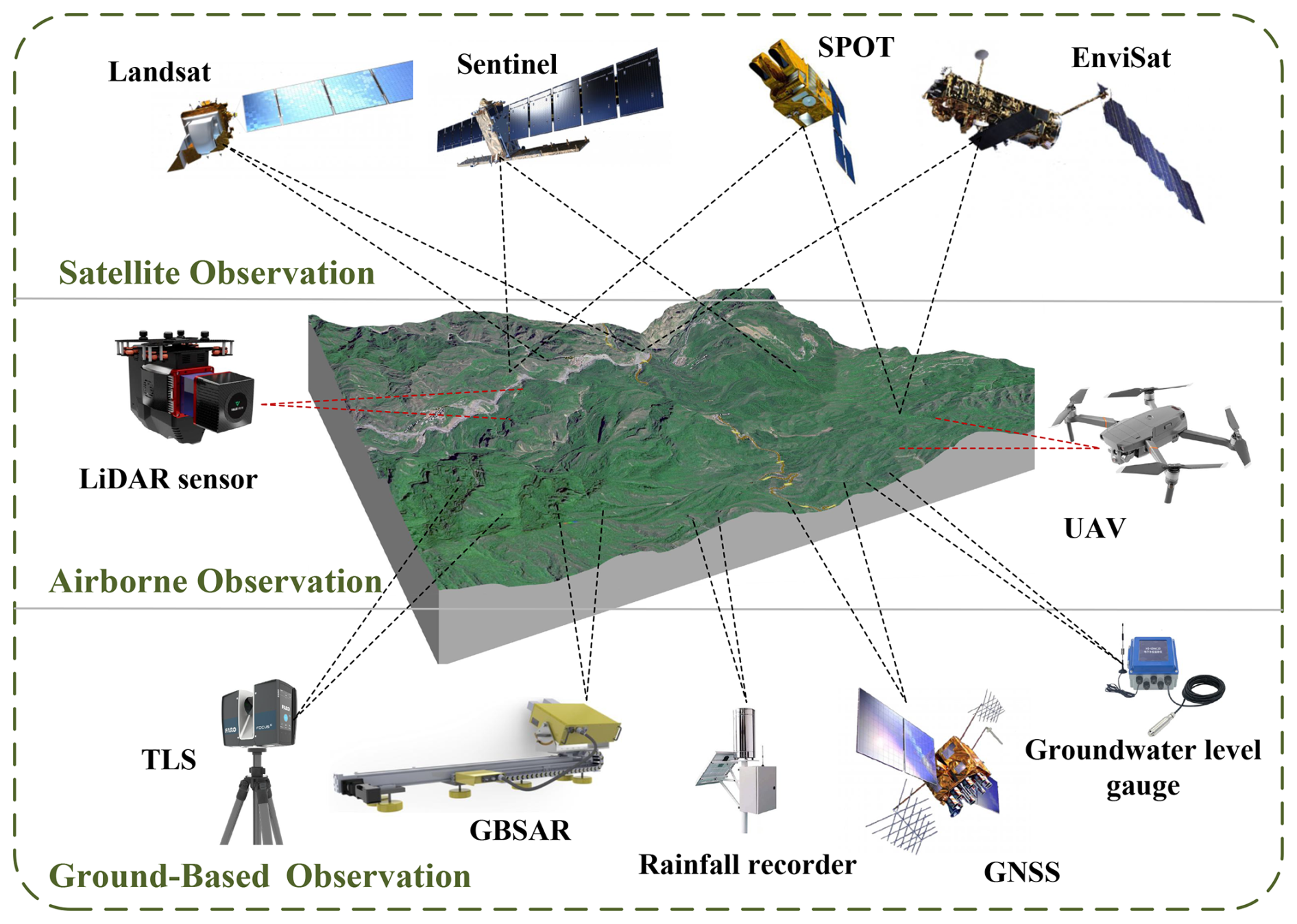
Figure 1Data sources for potential landslide identification. Satellite observations (e.g., Landsat, Sentinel, SPOT, and Envisat) provide optical and radar imagery with varying spatial resolutions for detecting and mapping landslides. Airborne observations (LiDAR, UAV) deliver high-resolution topographic and photographic data, while ground-based observations (TLS, GBSAR, GNSS, rainfall and groundwater sensors) offer continuous in-situ monitoring of slope dynamics.
2.1.1 Space-borne SAR
SAR is an active microwave remote sensing system (Franceschetti and Lanari, 2018). It is not only capable of acquiring data on demand by actively emitting microwave signals but also facilitates partial penetration of vegetation cover through its longer wavelength bands (such as the L-band), thereby allowing the retrieval of surface deformation information beneath vegetated areas.
A critical operational advantage of SAR lies in its capacity to image regardless of illumination (day or night) and weather conditions (Koukiou, 2024). The continuous, unimpeded time series data this provides is essential for serving as input to deep learning models, allowing these models to be trained to identify long-term patterns of terrain change. For this reason, SAR is widely employed for the crucial task of continuous monitoring in high-risk environments, where cloud cover and the timing of a disaster are unpredictable.
Notably, the NASA-ISRO SAR Mission (NISAR), jointly developed by the National Aeronautics and Space Administration (NASA) and the Indian Space Research Organisation (ISRO), was successfully launched in 2025 (Indian Space Research Organisation, 2025; NASA, 2025). The satellite carries both L-band and S-band SAR systems, enabling more precise and frequent measurements of surface deformation. With a revisit period of approximately 12 d, it delivers globally consistent coverage with a balanced spatial and temporal resolution. This capability provides researchers with abundant and continuous observations, supporting large-scale, high spatiotemporal resolution landslide early detection and dynamic monitoring.
Interferometric SAR (InSAR) has been developed based on the principle of measuring phase differences between two or more SAR images of the same area (Dai et al., 2022; Ma et al., 2023b; Zeng et al., 2024). By coherently processing these images, InSAR obtains high-precision surface elevation information and can be further applied to detect ground deformation.
In contrast, SAR mainly provide backscatter information of ground objects. Although some features of ground objects can be identified according to the scattering characteristics, their ability to obtain topographic elevation information is relatively weak. InSAR, on the other hand, can directly generate topographic elevation data, which is of great significance for analyzing the topography and geomorphology in the identification of potential landslides, and determining key elements such as the topographic undulation and slope of potential landslide areas.
When screening for potential landslides over a large area, InSAR has higher efficiency (Dun et al., 2021; Tang et al., 2025; Zhang et al., 2021). When monitoring large potential landslide areas such as mountainous regions, InSAR can quickly obtain topographic deformation information over a large area, promptly detect potential areas with potential landslides, and reduce the workload and blind spots of manual inspections.
Recent studies have integrated InSAR-derived deformation velocity fields with deep learning models to automatically detect slow-moving or latent landslides. For example, Liu et al. (2022d) employed an InSAR-CNN framework to map active landslides in the Eastern Tibet Plateau area, achieving a detection accuracy of over 90 %. Similarly, Zhang et al. (2022d) proposed a two-stage detection deep learning network (InSARNet) for detecting anomalous deformation areas in Maoxian County, Sichuan Province, with a recognition accuracy of 93.88 %. Targeting the complex deformation mechanisms of multi-type landslides in Zigui County, Three Gorges Reservoir Area, Hu et al. (2025b) used InSAR time-series displacement as the core data, develop a deep learning architecture based on the integrated framework of EMD and GRU, break through the limitations of conventional models such as single-type, single-target, and low-accuracy, and achieve dual-accurate prediction of displacement and failure time for multi-type landslides.
Differential InSAR (D-InSAR) is an advancement of InSAR that eliminates topographic phase through differential processing, focusing specifically on deformation information extraction (Shen et al., 2022). The emergence of D-InSAR not only enables the transition from mixed deformation-topography signals to pure deformation signal extraction but also extends its applicability from detecting discrete deformation events to identifying slow-moving landslide processes, significantly enhancing the reliability of landslide monitoring (Zhong et al., 2024).
2.1.2 Optical Remote Sensing
Optical remote sensing refers to the acquisition of surface information through sensors that measure reflected solar radiation. Its application in geological hazard investigations dates back to the 1970s (Fu et al., 2024; Liu and Wu, 2016).
Optical remote sensing offers high resolution, currently capable of achieving spatial resolutions as fine as 0.3 m or better. For example, Maxar's WorldView-3 delivers 0.31 m panchromatic imagery (Hu et al., 2016; Longbotham et al., 2014), while India's Cartosat-3 satellite achieves panchromatic imagery with a resolution of up to 0.25 m (Gupta et al., 2024). In potential landslide identification, it not only facilitates the retrieval of detailed surface textures and color characteristics using rich spectral data but also enables the direct identification of morphological features and object contours via visual interpretation of imagery (Cheng and Han, 2016; Li et al., 2022b; Ma and Wang, 2025).
Landslide formation typically follows a progressive process from deformation to failure, accompanied by precursor indicators such as tensile cracks, stepped scarps, and localized collapses. These indicators exhibit distinct spectral signatures in optical imagery compared to their surroundings, enabling both manual interpretation and automated detection. In deep learning applications, multispectral optical images have been widely used to train CNN-based models for potential landslide identification. Lu et al. (2023a) developed a method for achieving accurate landslide mapping using medium-resolution remote sensing images and DEM data, which has the potential for deployment in large-scale landslide detection. Jiang et al. (2022a) proposed a TL-Mask R-CNN for identifying a small number of old landslide samples in the area along the Sichuan-Tibet Transportation Corridor. The results show that the pixel accuracy of segmentation for new landslides and old landslides can reach 87.71 % and 75.86 % respectively.
In vegetated mountainous regions, surface vegetation often undergoes detectable changes before a landslide event. Optical remote sensing leverages multispectral data, particularly red and near-infrared bands, to monitor vegetation health and identify potential landslide zones (Coluzzi et al., 2025; Fiorucci et al., 2018). Furthermore, the calculation of the Normalized Difference Vegetation Index (NDVI) facilitates the evaluation of vegetation health in potential landslide regions, providing critical insights into potential landslide precursors (Verrelst et al., 2015).
However, the broad spectral bands of multispectral sensors limit their ability to detect more subtle, diagnostically specific precursory signals. The advancement beyond broad-band multispectral imaging to hyperspectral imaging has opened new avenues for landslide precursor detection (Kilgore and Restrepo, 2025; Ye et al., 2019). Hyperspectral sensors capture hundreds of contiguous spectral bands, enabling the identification of specific mineralogies (e.g., expansive clays like smectite that influence slope stability) and subtle geochemical alterations on slope surfaces. For instance, the shifting absorption features in the short-wave infrared region can signal changes in soil water content and mineral composition that often precede failure (Thimsen et al., 2017). The integration of these rich spectral datasets with deep learning architectures has significantly advanced automated landslide analysis (Huang et al., 2022c; Shahabi et al., 2021). These models excel at learning complex patterns from high-dimensional spectral-spatial information, enabling highly accurate detection of landslide scars and even precursory features like cracks and seepage zones that are otherwise challenging to identify.
While both space-borne SAR and optical remote sensing are pivotal for large-area landslide screening, they offer complementary capabilities and have distinct limitations. Optical remote sensing provides intuitive visual interpretation of geomorphological features but is rendered useless by cloud cover and darkness. In contrast, space-borne SAR, with its all-weather, day-and-night imaging capability, excels in detecting millimeter-to-centimeter-scale surface deformation through InSAR techniques, which is a direct precursor to landslide failure. However, InSAR performance can be degraded in heavily vegetated areas due to temporal decorrelation and in steep terrain due to geometric distortions (Lin et al., 2022; Yan et al., 2024), areas where optical stereo imaging for DEM generation might be less affected. Therefore, the integration of SAR-derived deformation maps and optical-based geomorphological maps is considered a best practice for regional-scale landslide inventory mapping and preliminary hazard assessment (Xun et al., 2022).
2.2 Airborne Remote Sensing Data
Airborne remote sensing data, typically acquired by manned aircrafts, provide high-resolution imagery of localized areas. Advanced airborne platforms equipped with oblique photogrammetry and, more recently, close-range photogrammetry technologies enable millimeter-level accuracy in 3D photogrammetry, facilitating the observation of subtle surface deformations, rock mass structures, and the construction of highly detailed 3D models of terrain and above-ground infrastructure (Macciotta and Hendry, 2021; Xu et al., 2023). Among these technologies, airborne photogrammetry and airborne radar are the most commonly used.
2.2.1 Airborne Light Detection and Ranging (LiDAR)
LiDAR has been used for landslide and other geological hazard investigations in many regions since the late 1990s. As an active remote sensing system, LiDAR can laterally scan a range of 60° and capture 400 000 points per second, enabling large-scale 3D scanning of terrain, structures, and vegetation within a short period (Mallet and Bretar, 2009). It offers centimeter-level accuracy in both horizontal and vertical dimensions.
Airborne LiDAR is irreplaceable in capturing 3D details and penetrating vegetation, particularly in densely vegetated areas where conventional aerial photography faces significant limitations. Airborne LiDAR not only acquires high-resolution Digital Surface Models (DSMs) from laser point cloud data but also generates high-accuracy DEMs by removing vegetation contributions (Fang et al., 2022; Jaboyedoff et al., 2012; Yan et al., 2023), thereby revealing concealed hazard features such as mountain fractures, loose deposits, and landslide masses under vegetation cover.
Point cloud data obtained from airborne LiDAR can monitor dynamic changes in mountainous terrain by detecting deformations such as subsidence, displacement, and uplift, while also facilitating the construction of 3D landslide models to simulate sliding directions and impact areas. Through intuitive visualization of slope morphology and structure from multiple perspectives, LiDAR enables researchers to conduct a comprehensive assessment of slope conditions and identify subtle hazard features that may not be easily discernible in 2D imagery.
These high-precision DEMs and point clouds serve as critical inputs for deep learning models. For instance, Wei et al. (2023) proposed the Dynamic Attentive Graph Network (DAG-Net) model to construct dynamic edge features for enhancing point cloud representations, achieving the highest mean Intersection over Union (mIoU) of 0.743 and an F1-score of 0.786. Based on the advanced PointNet and PointNet architectures, Farmakis et al. (2022) developed deep neural networks for 3D point cloud learning. The best-performing model achieved accuracies of approximately 89 % and 84 % during the final and shortest monitoring campaigns, respectively. These examples demonstrate that airborne LiDAR data are not only suitable but have been effectively applied in deep learning-based landslide analysis.
2.2.2 Unmanned Aerial Vehicle (UAV)
UAV aerial photogrammetry provides outstanding maneuverability and high-precision measurements. Traversing over steep slopes and valleys, UAVs are able to monitor areas that are often inaccessible to satellites and manned aerial platforms (Niethammer et al., 2012), thus addressing critical observational limitations.
In large-scale and topographically complex regions, UAVs can perform efficient aerial inspections, overcoming the limitations of ground-based inspections in inaccessible or visually obstructed regions. By rapidly scanning mountain slopes, embankments, and gullies, UAVs provide a comprehensive understanding of the geological conditions and enable timely identification of macro-scale geomorphic anomalies. However, given cost-effectiveness constraints, UAVs are currently more commonly used for periodic and continuous monitoring in localized areas. They are particularly well-suited for rapid and dynamic monitoring of landslides in high-priority zones.
With the rapid advancement of UAVs, centimeter-level vertical and oblique aerial photogrammetry is now achievable (Fan et al., 2020). The high-definition cameras mounted on UAVs are able to capture the subtle cracks on the surface of the mountain. These cracks may be early signs of a landslide (Sun et al., 2024a). By conducting a comparative analysis of the images taken at different times, the development and changes of the cracks can be monitored, including the increase in the length, width and depth of the cracks, as well as the changes in the crack orientation.
In some mountainous areas or valleys, there may be a large number of loose accumulations. These accumulations may trigger landslides under specific conditions. Aerial photography by UAVs can clearly identify information such as the distribution range, accumulation quantity and accumulation shape of these loose accumulations, and assess their potential threats to the surrounding environment. This capability is leveraged in deep learning applications, where time-series UAV imagery is processed using RNNs or 3D CNNs to monitor the spatiotemporal evolution of these cracks, providing a data-driven approach for early warning (Xu et al., 2025; Sandric et al., 2024).
Airborne platforms bridge the gap between satellite and ground-based observations. LiDAR is unparalleled in generating high-precision DEM, revealing concealed paleo-landslides and subtle topographic features critical for hazard mapping. However, its deployment is costly and logistically complex. UAVs, as a flexible and cost-effective alternative, have democratized high-resolution data acquisition. They can be equipped with various sensors (e.g., optical, multispectral, and even lightweight LiDAR) to conduct rapid response surveys following triggering events such as earthquakes or heavy rainfall (Han et al., 2023). While UAV-derived models have ultra-high resolution, their coverage is limited per sortie compared to airborne campaigns. The choice between them often involves a trade-off between coverage, cost, operational flexibility, and the specific requirement for vegetation penetration.
By equipping UAVs with LiDAR sensors to effectively remove vegetation from the data, this integrated approach combines the strengths of photogrammetry and LiDAR (Mandlburger et al., 2020; Wallace et al., 2012). It allows researchers to reveal landslide boundaries, crack patterns, and other deformation features hidden beneath vegetation cover, enabling rapid deployment and targeted area monitoring while mitigating vegetation-related challenges in landslide assessment.
2.3 Ground-based Observation Data
Satellite observation and airborne remote sensing are mainly employed for identifying potential landslides based on surface morphology. However, these approaches are often affected by vegetation cover, viewing geometry, and atmospheric noise, which may lead to misclassification or omission (Almalki et al., 2022; Dubovik et al., 2021). Therefore, ground-based observation techniques play a critical complementary role, offering higher temporal resolution, accuracy, and localized verification for potential landslide identification. In recent years, data collected from ground-based monitoring instruments have not only been used for field validation but also increasingly incorporated into deep learning frameworks to improve temporal continuity and physical interpretability in landslide detection and forecasting.
2.3.1 Ground-based Synthetic Aperture Radar (GB-SAR)
GB-SAR is an active ground-based microwave remote sensing system that has been developed over the past decade, effectively integrating the principles of SAR imaging with electromagnetic wave interferometry. By leveraging precise measurements of sensor system parameters, attitude parameters, and geometric relationships between orbits, GB-SAR quantifies spatial positions and subtle changes at specific surface points, allowing for the measurement of surface deformations with millimeter or even sub-millimeter precision.
Compared with spaceborne SAR, GB-SAR can adjust the incidence and azimuth angles of radar waves, thereby avoiding phase decorrelation caused by terrain-induced occlusion in spaceborne observations. Consequently, they are particularly suitable for monitoring steep slopes, canyons, and other areas with limited line-of-sight coverage from satellites (Noferini et al., 2007).
During landslide movement, the ground experiences noticeable subsidence, displacement, or cracking. GB-SAR can be configured for high-resolution, continuous observation to capture instantaneous deformations during the landslide creep phase and generate corresponding displacement maps (Liu et al., 2021a; Xiao et al., 2021). For example, Long et al. (2018) proposed a GBSAR persistent scatterer point selection method based on the mean coherence coefficient, amplitude dispersion index, estimated signal-to-noise ratio, and displacement accuracy index. Han et al. (2022) proposed an LSTM-based approach for processing GB-InSAR time series data.
For small-scale regional monitoring, GB-SAR can establish customized geometric configurations specifically designed for target areas. Utilizing mobile rail systems or multi-antenna setups, GB-SAR reconstructs 3D deformation vector fields of landslide masses (Shi et al., 2025), identifying sliding directions and potential failure surfaces.
2.3.2 Terrestrial Laser Scanning (TLS)
TLS emerged in the mid-1990s. It plays a unique role in local refined monitoring by emitting laser pulses and measuring their reflection time (Stumvoll et al., 2021; Teza et al., 2007).
The landslide often manifests as a sharp change in the ground surface. TLS can provide data with sufficient accuracy, assisting researchers in identifying the features of these landslides (Abellán et al., 2009; Teng et al., 2022).
By quickly and massively collecting spatial point position information, TLS can automatically splice and rapidly obtain the appearance of the measured object. It can be used to construct high-precision surface models and appearance models of buildings and structures. The 3D model can display the shape and structure of the mountain and the detailed features of the ground surface from different angles and in all directions (Zhou et al., 2024a), enabling geological experts and engineers to have a more intuitive understanding of the overall situation of the landslide area. For example, the cracks in the mountain, the loose accumulations, and the degree of weathering of the rocks can be clearly seen, providing richer information for the identification of potential landslide hazards.
In the context of deep learning, TLS-derived 3D point clouds have become critical inputs for morphological feature extraction and automatic landslide identification. For example, Senogles et al. (2022) integrated TLS point cloud data to assess surface displacements induced by landslide movements. Wang et al. (2025) provided a practical and adaptable solution for landslide monitoring by integrating TLS point clouds with embedded RGB imagery.
These examples confirm that TLS data are not only suitable but already actively used in deep learning-based landslide recognition, providing precise geometric constraints for multi-source fusion frameworks that combine DEM, optical, and InSAR information.
Ground-based techniques provide the highest precision for monitoring a specific slope of interest. GB-SAR and TLS are both non-contact remote sensing methods, but they operate on different principles. GB-SAR offers continuous, all-weather, mm-level deformation monitoring over a large area (several km2) from a single station, making it ideal for early warning. Its drawback is the need for a stable, opposing installation point with a clear line-of-sight (Monserrat et al., 2013). TLS, on the other hand, provides mm-to-cm-level 3D point clouds of the slope surface, excellent for quantifying volume changes and detailed geometric changes. However, it is typically used for periodic surveys rather than continuous monitoring and has occlusion shadows (Huang et al., 2019).
2.3.3 Ground-based Sensor Devices
Compared to the aforementioned data sources, ground-based sensors offer key advantages, including high precision, real-time capabilities, and multi-parameter fusion (Dai et al., 2023). They can address the limitations of remote sensing and provide critical ground-based dynamic information for potential landslide identification.
Ground-based sensing devices are highly diverse, and the data they acquire directly reflect the state of landslide masses. These datasets provide foundational inputs for deep learning models, enabling multi-dimensional analysis and interpretation of potential landslide conditions. For example, ground sensors (e.g., GNSS receivers and crack meters) can collect parameters like displacement and tilt angle at frequencies ranging from minutes to seconds, capturing transient, anomalous signals just prior to landslide events, thereby filling the temporal resolution gap in remote sensing (see Fig. 1). These data are often used as input sources for RNN models and their variants (Bai et al., 2022; Wang et al., 2021a). By integrating time series data with SAR imagery, deep learning models can be trained to uncover correlation patterns between surface deformations and subsurface parameters (Jiang et al., 2022b). Instruments such as piezometers and soil pressure gauges can directly monitor key parameters like pore water pressure and soil stress on the sliding surface. By combining the obtained subsurface data with geomechanical equations, the position of the sliding surface or geotechnical strength parameters can be inferred.
Therefore, GB-SAR, TLS, and ground-based sensors are not only auxiliary observation techniques but are increasingly serving as key data sources for deep learning-driven landslide identification. Their integration into CNN, LSTM, and Generative Adversarial Network (GAN) frameworks enables high-resolution spatial-temporal modeling of slope behavior, bridging the gap between field-scale monitoring and large-scale hazard prediction.
2.4 Summary of Data Source for Potential Landslide Identification
In summary, no single data source is sufficient for a comprehensive potential landslide identification framework. Regional-scale satellite data, particularly InSAR, is optimal for the early detection of pre-landslide deformations over vast areas. Airborne platforms, such as UAVs, then provide high-resolution optical and LiDAR data to characterize the precise geometry and activity of identified potential landslides. Finally, ground-based and in-situ sensors enable site-specific, real-time monitoring of high-risk slopes, validating remote sensing findings and supporting early warning systems. The strategic integration of these multi-platform data is crucial for transitioning from regional screening to mechanistic understanding and risk mitigation.
Beyond these general data modalities, recent years have also witnessed the emergence of benchmark datasets that serve as standardized testbeds for developing and evaluating deep learning methods in landslide identification. Such datasets are essential for ensuring reproducibility, enabling fair comparison across models, and accelerating methodological advances. Representative examples include the CAS Landslide Dataset, a large-scale, multi-sensor dataset explicitly designed for deep-learning-based landslide mapping (Xu et al., 2024); the Landslide4Sense (L4S) benchmark, developed within an international competition, which provides multi-source satellite image patches (Ghorbanzadeh et al., 2022b); and the Diverse Mountainous Landslide Dataset (DMLD), which emphasizes high-resolution instances from complex mountainous terrains (Chen et al., 2024a). In addition, slope-unit-based benchmark datasets have been constructed to support susceptibility mapping and regional-scale comparisons (Martinello et al., 2021).
These datasets serve as valuable resources for pixel-level segmentation and slope-unit-based susceptibility modeling. However, in practice, the compilation of landslide inventories faces considerable challenges, making it difficult to obtain comprehensive and accurate records (Kong et al., 2025; Lee et al., 2018). Consequently, data scarcity remains a common issue in landslide hazard identification, particularly in remote regions or areas with limited accessibility. Therefore, it is necessary to further expand their geographical coverage and establish standardized evaluation protocols.
The effectiveness of deep learning in potential landslide identification largely depends on selecting an appropriate model architecture suited to the data type and specific task. While all deep learning models excel at automated feature extraction, their internal architectures predispose them to excel in different aspects of the overall workflow. Therefore, this section does not merely list models, but organizes them based on their primary function in the potential landslide identification pipeline. We analyze several commonly used deep learning models by categorizing them into five functional roles: image analysis and processing, time series analysis, data generation, anomaly detection, and data fusion.
3.1 Models for Image Analysis and Processing in Potential Landslide Identification
Image data plays a critical role in potential landslide identification, especially through remote sensing, satellite, and UAV imagery. These images enable the acquisition of large-scale terrain data, encompassing complex geographical features, vegetation coverage, and ground fissures, which often serve as potential precursors to landslide occurrences. The adoption of deep learning has facilitated a shift from conventional manual visual interpretation to automated high-precision segmentation.
CNNs, owing to their inherent capability to learn hierarchical and multi-scale spatial features (Kattenborn et al., 2021; LeCun et al., 1998; Liu et al., 2022b), have become the core methodological framework for most image-based deep learning applications in landslide research (see Fig. 2). This capability directly addresses a long-standing limitation of conventional classifiers, which struggle to simultaneously capture fine-scale precursors (e.g., narrow ground fissures) and large-scale landslide morphology within a unified framework. Multi-scale convolutional feature extraction has been shown to significantly enhance the sensitivity of landslide detection across a wide range of spatial extents (Hussain et al., 2019; Shi et al., 2020; Yao et al., 2021). For example, small convolutional kernels are particularly effective in identifying subtle surface disturbances, such as localized soil texture variations and ground cracks, which often precede slope failure. Hamaguchi et al. (2018) and Wang et al. (2024a) demonstrated that CNN-based models can detect extremely small and subtle features, including cracks as narrow as 0.05 m, a level of detail that is difficult to achieve using conventional texture-based methods.
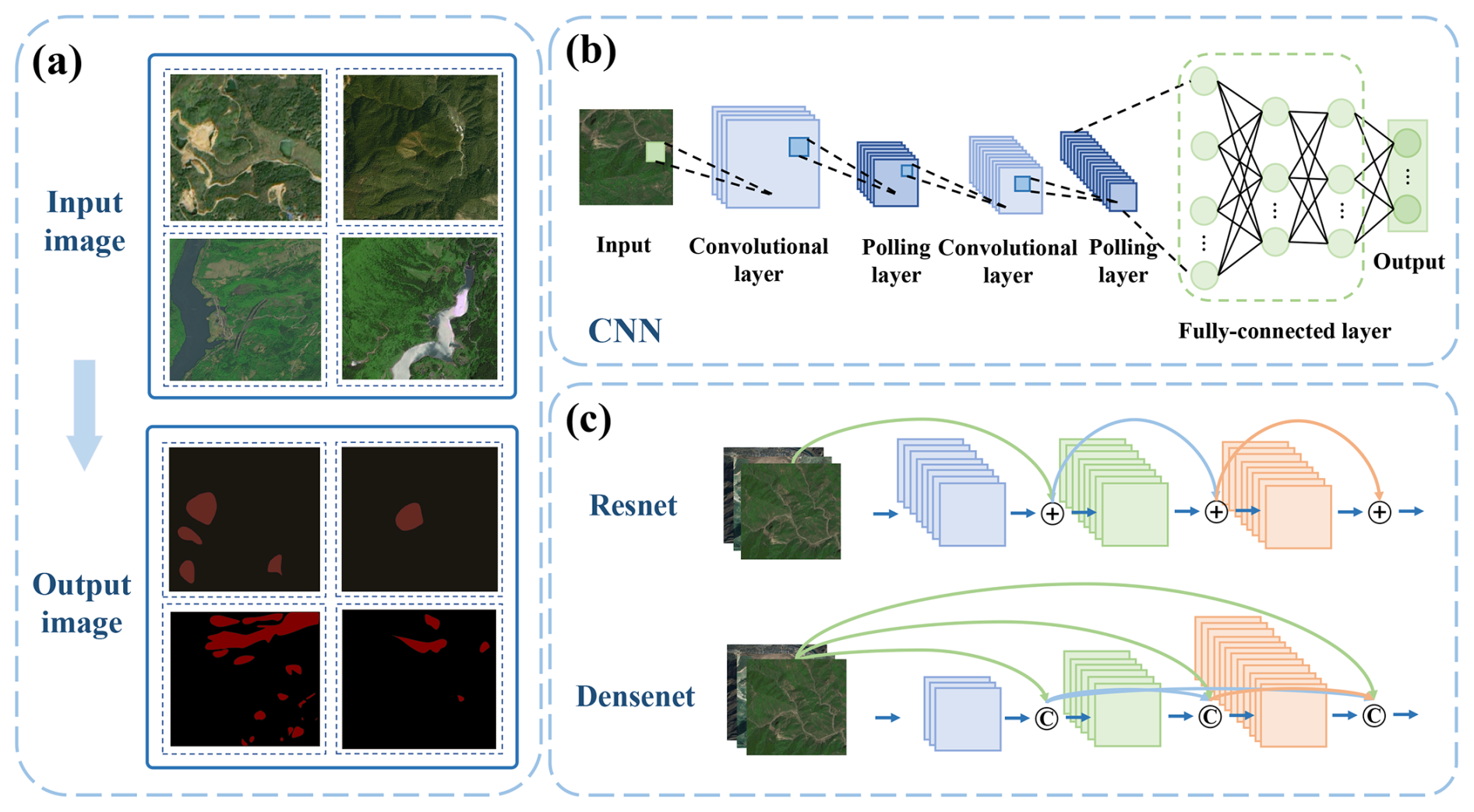
Figure 2Functional pipeline of CNN-based models for image analysis and processing. (a) Semantic mapping process: demonstrating the transition from optical input to binary classification for target identification. (b) Segmentation performance: visualizing the model's capability to delineate precise landslide boundaries (binary masks) from optical imagery. (c) Optimization strategies: comparing skip-connections and dense connectivity for enhancing gradient flow and feature reuse.
Conversely, larger convolutional kernels and multi-scale fusion strategies enhance the identification of overall landslide morphology and scar boundaries, which are critical for accurate inventory mapping. Ding et al. (2022) showed that larger kernels improve the shape bias of CNNs, facilitating the recognition of large-scale structural patterns, while Li et al. (2025b) demonstrated that scale-adaptive kernel fusion improves global perception of landslide extents and contextual background information. By integrating multi-scale feature extraction within a single model, CNN-based approaches outperform conventional machine-learning classifiers that depend on fixed-scale descriptors and often exhibit reduced generalization in heterogeneous terrain.
Beyond feature extraction, architectural innovations such as residual and dense connections have substantially improved the trainability and data efficiency of deep networks in landslide applications (He et al., 2016). Deep networks with increased depth generally exhibit stronger representational capacity but are prone to optimization difficulties and overfitting, particularly under limited training samples (Ebrahimi and Abadi, 2021).
Residual Networks (ResNet) address these challenges through shortcut connections (Qi et al., 2020; Yang et al., 2022), enabling stable training of very deep models and improved discrimination between landslide scars and surrounding vegetation or bare soil in complex terrains (see Fig. 2). However, deeper architectures also incur higher computational costs, which may constrain their practical deployment in large-scale or near-real-time mapping scenarios (Hasanah et al., 2023).
Dense Convolutional Networks (DenseNet) further enhance feature reuse and gradient flow through dense connectivity, reducing parameter redundancy and improving performance under limited training data conditions (Huang et al., 2017; Liu et al., 2021c). This property is particularly relevant for landslide studies, where high-quality labeled samples are often scarce and spatially clustered. Empirical studies indicate that DenseNet-based models can effectively extract multi-scale landslide features in complex terrain while maintaining computational efficiency (Cai et al., 2021; Li et al., 2021a; Ullo et al., 2021).
With the maturation of CNN backbones, semantic segmentation has emerged as the dominant paradigm for landslide detection, as it enables dense, pixel-level delineation of landslide extents that is essential for inventory construction and hazard assessment (Guo et al., 2018; Lu et al., 2023b; Zhou et al., 2024b). Among these models, U-Net and its variants have become benchmarks due to their encoder–decoder structure and skip connections, which preserve spatial detail and improve boundary delineation (Chandra et al., 2023; Chen et al., 2022; Meena et al., 2022; Ronneberger et al., 2015). U-Net-based models have demonstrated strong performance in challenging conditions, such as cloud-covered or topographically complex regions using SAR imagery (Nava et al., 2022).
However, U-Net's relatively limited receptive field can restrict its ability to capture long-range contextual information in heterogeneous geological settings. DeepLab addresses this limitation by incorporating dilated convolutions and Atrous Spatial Pyramid Pooling (ASPP), enabling effective fusion of local texture and global contextual cues without sacrificing spatial resolution (Chen et al., 2017; Huang et al., 2024). This multi-scale contextual modeling has been shown to reduce false positives and improve detection consistency in geologically complex environments, highlighting a key advantage of advanced deep segmentation models over simpler pixel-based or object-based approaches (Niu et al., 2018; Sandric et al., 2024).
Beyond static mapping, deep learning also facilitates multi-temporal change detection and dynamic hazard monitoring. By comparing segmentation outputs across time or directly processing multi-temporal image stacks, CNN-based models can characterize the spatial evolution of landslides and identify active deformation zones (Amankwah et al., 2022). Wang (2023) demonstrates that 3D CNNs enable joint modeling of spatial and temporal dependencies, producing both change hotspot maps and temporal evolution curves that capture landslide initiation and progression. Some studies even have integrated attention mechanisms into conventional CNN architectures to enhance the analysis of multi-temporal remote sensing imagery, thereby enabling the identification of landslide hazard evolution over time. For example, Meng et al. (2024) proposed a framework based on CNN and optimized Bidirectional Gated Recurrent Unit (BiGRU) with an attention mechanism, designed to forecast landslide displacement with a step-like curve. Dong et al. (2022) proposed L-Unet which combines multi-scale feature fusion with attention modules to improve landslide segmentation performance, particularly at boundaries.
Overall, image-based deep learning models represent a substantial methodological advance over traditional machine-learning classifiers in terms of multi-scale feature representation, mapping completeness, and robustness to complex backgrounds. Nevertheless, their performance remains contingent on data quality, sample representativeness, and computational resources, and they generally lack the explicit physical interpretability of process-based models. These limitations motivate increasing interest in hybrid framework.
3.2 Models for Time Series Analysis in Potential Landslide Identification
Landslide occurrence is inherently a time-dependent process, driven by the cumulative and often delayed effects of environmental forcing such as rainfall, groundwater fluctuation, reservoir operation, and seismic disturbance. Time series data describing slope displacement, pore-water pressure, rainfall intensity, or surface deformation provide critical information for identifying potential instability and forecasting landslide evolution. Unlike static susceptibility mapping, time series analysis directly targets the dynamic behavior of slopes and therefore plays a central role in early warning and short-term prediction (see Fig. 3).
Conventional statistical and physically based approaches have been widely used to analyze landslide-related time series. Statistical models typically assume linear or weakly nonlinear relationships and often require strong prior assumptions, while physically based models rely on simplified representations of hydromechanical processes and detailed parameterization that is difficult to obtain at scale. Deep learning-based temporal models offer a complementary data-driven alternative by automatically learning nonlinear dependencies, cumulative effects, and delayed responses directly from observations, without requiring explicit process equations.
RNNs represent the earliest class of deep learning models designed for sequential data, enabling the modeling of short-term temporal dependencies through recursive information flow (Elman, 1990; Ngo et al., 2021; Zaremba et al., 2014). In landslide studies, RNNs have been applied to displacement time series influenced by rainfall and groundwater variation, demonstrating their ability to capture short-term deformation trends prior to failure (Chen et al., 2015; Zhang et al., 2022c). However, standard RNNs often struggle with long-term dependencies and cumulative effects, which are common in landslide processes driven by prolonged or intermittent forcing (see Fig. 3).
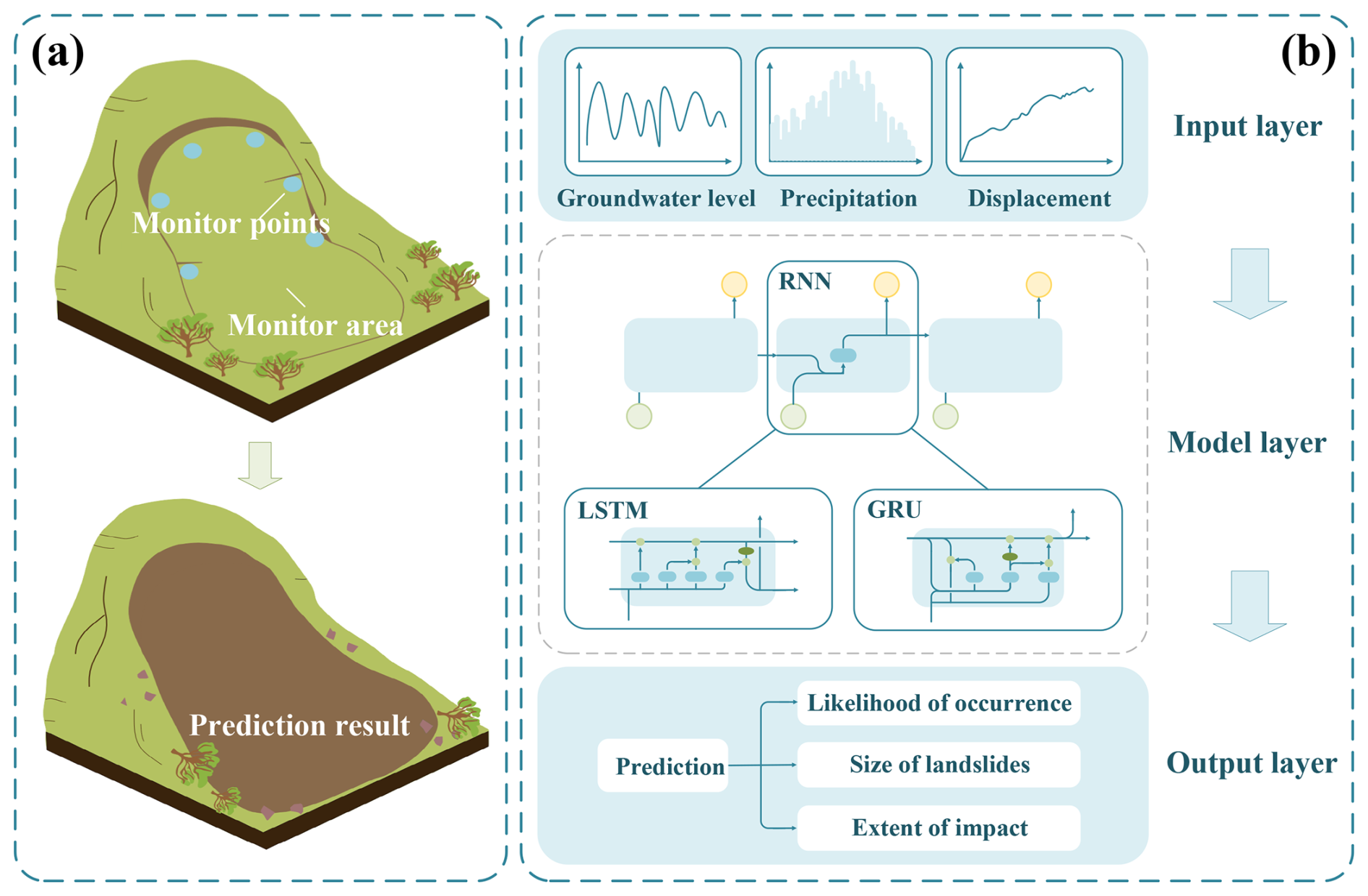
Figure 3Analytical framework of RNN-based models for time series analysis. (a) From field monitoring to predictive insight: outlining the transformation of multi-source field monitoring data into predictive landslide intelligence. (b) Processing temporal dependencies: illustrating the recursive logic of RNN, LSTM, and GRU in processing sequential variables.
To overcome the vanishing gradient problem inherent in RNNs, LSTM introduces memory cells and gating mechanisms that selectively retain relevant temporal information (Graves, 2012; Landi et al., 2021; Sherstinsky, 2020; Smagulova and James, 2019; Staudemeyer and Morris, 2019; Yu et al., 2019). This capability is particularly well aligned with landslide dynamics, where delayed and cumulative responses to rainfall or reservoir level fluctuations are critical precursors of instability. Empirical studies consistently demonstrate that LSTM-based models outperform conventional regression and shallow machine-learning approaches in displacement prediction and early warning tasks. For example, Yang et al. (2019) analyzed the relationships among landslide deformation, rainfall, and reservoir water levels, and found that compared with static models, the LSTM approach more accurately captured the dynamic characteristics of landslides and effectively leveraged historical information. Xu and Niu (2018) used a LSTM model to predict the displacement evolution of the Baijiabao landslide using rainfall and hydrological level data, achieving a higher correlation compared with traditional regression models. In another study focused on shallow landslides, Xiao et al. (2022) used a week-ahead LSTM model, which exhibited stable performance and improved prediction accuracy in short-term prediction scenarios. Additionally, Gidon et al. (2023) constructed a Bi-LSTM model and achieved a detection accuracy of 93 % in the Mawiongrim area.
Despite their strong performance, LSTM models are computationally demanding and may be prone to overfitting when training data are limited. GRUs provide a streamlined alternative by simplifying the gating structure while maintaining comparable predictive accuracy (Cho et al., 2014). This balance between model complexity and performance makes GRU-based models particularly attractive for real-time landslide monitoring and operational early warning systems, where computational efficiency and rapid updating are critical (Chung et al., 2014; Rawat and Barthwal, 2024; Zhang et al., 2022e). Recent studies indicate that GRUs can effectively identify acceleration phases in displacement time series, enabling earlier detection of rainfall- or earthquake-induced slope instability (Chang et al., 2025; Yang et al., 2025).
More recently, Transformer-based architectures have emerged as powerful alternatives for time series modeling by leveraging self-attention mechanisms to capture long-range temporal dependencies in parallel (Vaswani et al., 2017). Compared with recurrent models, Transformers are particularly effective at modeling long-term and non-local temporal relationships, which are often present in landslide processes influenced by multi-seasonal rainfall or complex hydrological regimes. In landslide-related applications, Transformers can adaptively learn latent temporal features across diverse scenarios and outperform conventional RNN-based models in capturing complex temporal patterns (Esser et al., 2021; Huang and Chen, 2023; Wang et al., 2024b; Zerveas et al., 2021).
However, a key drawback of the standard Transformer is its quadratic computational complexity with respect to sequence length, which becomes prohibitive for very long sequences (Zhuang et al., 2023). This also complicates the interpretation of how the model extracts features and makes decisions from large amounts of landslide data, posing challenges for practical deployment. It is worth noting that mitigating this quadratic complexity is an active research area, with many efficient Transformer variants being developed. For example, Zhao et al. (2024f) combined the strengths of CNN and Transformer architectures, selecting and analyzing nine landslide-conditioning factors to successfully achieve accurate landslide localization and detailed feature capture. Ge et al. (2024) proposed the LiteTransNet model based on the Transformer framework, effectively capturing and interpreting the varying importance of historical information during the prediction process. Therefore, while powerful, the vanilla Transformer may not be the optimal choice for all practitioners, and its computational demands should be carefully considered.
In summary, deep learning-based time series models represent a significant advancement over conventional statistical approaches by enabling data-driven learning of nonlinear, delayed, and cumulative deformation patterns that are difficult to encode explicitly in physical models. RNNs and LSTMs remain effective and interpretable for short- to medium-term prediction tasks, while GRUs offer computationally efficient solutions for operational systems (Li et al., 2021b; Wang et al., 2020b). Transformer-based models provide superior capacity for long-term dependency modeling but require careful consideration of data availability, computational resources, and interpretability. These trade-offs highlight the importance of selecting temporal architectures based on specific monitoring objectives, data characteristics, and operational constraints.
3.3 Models for Data Generation in Potential Landslide Identification
A fundamental challenge in potential landslide identification lies in the scarcity, imbalance, and spatial clustering of labeled landslide samples. Landslide inventories are often incomplete, biased toward large or easily detectable events, and unevenly distributed in space and time. These limitations significantly constrain the performance and generalization ability of both traditional machine-learning classifiers and deep learning-based models, particularly in data-hungry settings. Data generation aims to alleviate these issues by learning the underlying data distribution and synthesizing new samples that are statistically consistent with observed landslide patterns (Kingma et al., 2014; Moreno-Barea et al., 2020; Shorten and Khoshgoftaar, 2019).
Conventional data augmentation techniques (e.g., rotation, flipping, noise injection) provide limited diversity and do not fundamentally address class imbalance or morphological variability in landslide datasets. Deep generative models represent a major methodological advance by explicitly modeling the latent distribution of geospatial features, thereby enabling the creation of realistic and diverse synthetic landslide samples (Alam et al., 2018; Karras et al., 2020; Ma et al., 2024; Xu et al., 2015). Unlike discriminative models, generative models capture probabilistic representations of terrain, deformation, or image features, making them particularly suitable for addressing uncertainty, rarity, and heterogeneity in landslide data. Commonly used deep generative models include GANs, Variational Autoencoders (VAEs), and diffusion models (see Fig. 4).
GANs are among the most widely adopted generative models for landslide-related data augmentation, particularly in remote sensing imagery. Through adversarial training between a generator and a discriminator, GANs can produce visually realistic synthetic samples that closely resemble real landslide images (Goodfellow et al., 2014; Gui et al., 2021; Saxena and Cao, 2021). In potential landslide identification, this capability can address the shortage of labeled image samples that limits the performance of segmentation and classification models. For example, Feng et al. (2024) achieved the first implementation of using a GAN to generate synthetic high-quality landslide images, aiming to address the data scarcity issue that undermines the performance of landslide segmentation models. Al-Najjar and Pradhan (2021) proposed a novel approach that employs a GAN to generate synthetic inventory data. The results indicate that additional samples produced by the proposed GAN model can enhance the predictive performance of Decision Trees (DT), Random Forest (RF), Artificial Neural Network (ANN), and Bagging ensemble models.
Despite their effectiveness, GAN-based approaches exhibit notable limitations. Mode collapse may reduce sample diversity, particularly for rare landslide types or extreme morphologies, and training instability often necessitates careful hyperparameter tuning and substantial computational resources (Fang et al., 2020). Such constraints can limit their applicability in operational or real-time hazard assessment. Recent architectural refinements, including Conditional GAN (CGAN) (Kim and Lee, 2020; Loey et al., 2020; Mirza and Osindero, 2014), image-to-image translation with GAN (Pix2Pix) (Isola et al., 2017; Qu et al., 2019), and Wasserstein GAN (WGAN) (Arjovsky et al., 2017; Wang et al., 2019), partially mitigate these issues by improving training stability and enabling conditional or controlled sample generation. As a result, GANs are increasingly viable for high-resolution landslide image synthesis and remote sensing–based susceptibility analysis, particularly when visual realism is a primary requirement.
As a probabilistic variant of AEs, VAEs introduce latent-space regularization through variational inference (see Fig. 4). Compared with GANs, VAEs prioritize distributional coverage and uncertainty representation over visual sharpness (Hinton and Salakhutdinov, 2006; Kingma and Welling, 2013), making them well suited for probabilistic modeling of landslide processes. For instance, Cai et al. (2024) demonstrated that a VAE-GRU framework can generate narrow predictive intervals while maintaining high coverage probabilities, representing a substantial improvement over the state-of-the-art methods. Such probabilistic outputs are particularly valuable for risk-informed decision-making and early warning applications (Islam et al., 2021; Oliveira et al., 2022).
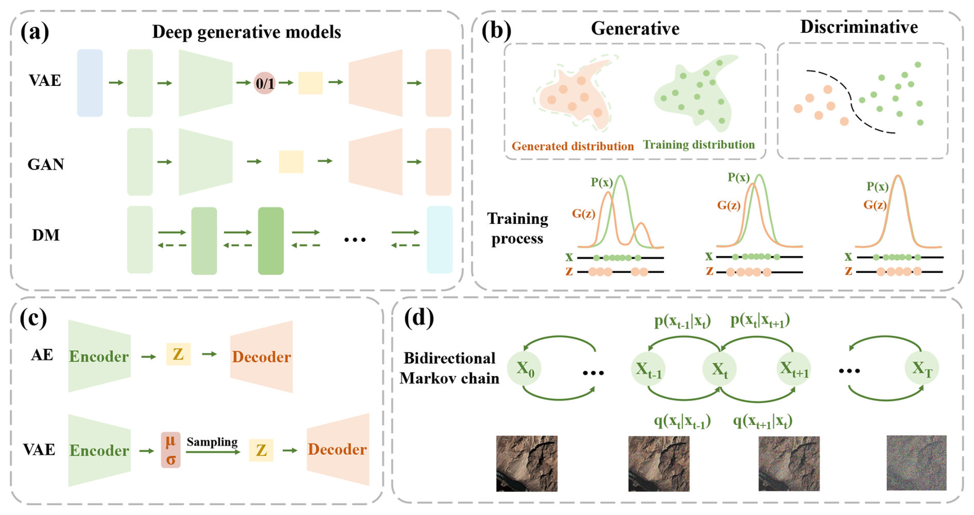
Figure 4Comparative mechanisms of deep generative models for data generation. (a) Contrasting fundamental training objectives: VAE (maximizing variational lower bounds), GAN (adversarial gaming), and Diffusion models (iterative noise reversal). (b) Adversarial learning: function of the generator-discriminator competition in improving sample fidelity. (c) Latent space modeling: highlighting the probabilistic sampling layer in VAEs that enables diverse sample generation compared to standard AEs. (d) Iterative denoising: the mechanism of reconstructing high-resolution imagery through reverse diffusion.
Compared with GANs, VAEs produce more diverse but slightly less detailed samples, due to their structured latent space constraints. This characteristic is particularly beneficial for exploring a wide range of potential landslide morphologies and for augmenting training datasets used in susceptibility prediction. However, VAEs may still struggle with highly imbalanced datasets, as their probabilistic reconstruction tends to favor majority classes. Integrating VAEs with stratified sampling or cost-sensitive learning could help overcome this limitation and further enhance landslide prediction performance.
When computational resources and training time permit, diffusion models provide a powerful alternative for generating high-quality, diverse, and stable data (Croitoru et al., 2023; Ho et al., 2020; Yang et al., 2023a; Zhu et al., 2023a). These models learn the data distribution by gradually adding noise to real samples (forward diffusion) and then reconstructing clean data through a reverse denoising process (see Fig. 4). The resulting models can sample new, realistic data points that reflect complex terrain and geophysical variability. For example, Lo and Peters (2024) proposed a Terrain-Feature-Guided Diffusion Model (TFDM) to fill gaps in DEM data. Similarly, Zhao et al. (2024b) employed a Denoising Diffusion Probabilistic Model (DDPM) conditioned on incomplete DEMs, which serves as a transitional kernel during diffusion reversal to progressively reconstruct sharp and accurate DEM.
Despite their successful applications in image synthesis, denoising, and remote-sensing image enhancement (Leher et al., 2025; Sui et al., 2024; Xiao et al., 2023; Zou et al., 2024), diffusion models have not yet been widely applied directly to the identification of potential landslides and remain in the exploratory stage. Nonetheless, our optimism for their application is grounded in their potential to address key challenges such as limited labeled data through generative augmentation and, more importantly, to provide uncertainty quantification in predictions, which is vital for risk assessment.
In summary, deep generative models provide an essential complement to discriminative deep learning and conventional machine-learning approaches in potential landslide identification. Among them, GANs are effective for generating visually realistic imagery and data augmentation; VAEs capture probabilistic geomorphic transitions; and diffusion models ensure stability and fidelity in high-resolution terrain synthesis. Rather than replacing predictive models, generative approaches primarily enhance data quality, diversity, and uncertainty representation, thereby strengthening the robustness and generalization of landslide identification and forecasting frameworks.
3.4 Models for Anomaly detection in Potential Landslide Identification
Anomaly detection provides a complementary perspective to supervised landslide classification by focusing not on what constitutes a landslide, but on when and where a slope begins to deviate from its normal state. In potential landslide identification, this paradigm is particularly valuable because catastrophic failures are often preceded by subtle, progressive, and spatially heterogeneous signals. Typical anomalies include unexpected acceleration in surface displacement, coherence loss in InSAR observations, or irregular fluctuations in multi-sensor monitoring data, which may emerge well before visible slope failure (Deijns et al., 2020; Jiang et al., 2020).
Compared with conventional anomaly detection approaches based on empirical thresholds or predefined statistical rules, deep learning-based methods offer a critical advantage: they can learn complex, nonlinear “normality patterns” directly from data, without requiring explicit assumptions about failure modes. This shift is especially important in landslide-prone environments, where background variability driven by rainfall, vegetation dynamics, and sensor noise often masks early instability signals. By modeling high-dimensional spatiotemporal dependencies, deep learning enables a more adaptive and context-aware identification of abnormal slope behavior.
AEs constitute the most widely adopted framework for unsupervised anomaly detection in landslide monitoring. Rather than explicitly detecting failures, AEs are trained to reconstruct normal system states, such as stable slope displacement time series or radar backscatter signatures (Sakurada and Yairi, 2014; Zhou and Paffenroth, 2017). When exposed to abnormal inputs (such as sudden deformation acceleration or coherence degradation) the reconstruction error increases, providing an implicit indicator of potential instability. This reconstruction-based logic is particularly attractive in landslide applications, where labeled failure data are scarce or incomplete. For instance, Shakeel et al. (2022) developed an InSAR deformation anomaly detector based on an AE-LSTM architecture. Experimental analyses using synthetic deformation test scenarios achieved an overall performance accuracy of 91.25 %.
However, deterministic AEs implicitly assume that “normal” patterns can be represented by a single compact manifold, which may be insufficient for landslide systems characterized by multiple deformation regimes. VAEs address this limitation by explicitly modeling uncertainty in the latent space through probabilistic inference (Kumar et al., 2024; Pol et al., 2019). By learning a distribution rather than a single representation of normal slope behavior, VAEs are better suited to capture the intrinsic variability of environmental and geotechnical conditions (Kingma and Welling, 2013; Li et al., 2020; Park et al., 2018). Recent studies indicate that VAEs outperform conventional AEs when anomaly detection involves multivariate inputs combining displacement, rainfall, and hydrological factors, enabling a more robust identification of transitional instability stages (Nawaz et al., 2024; Han et al., 2025). Nevertheless, the probabilistic nature of VAEs also introduces practical challenges, including higher data requirements and the need for operationally meaningful thresholding strategies.
GANs offer an alternative perspective on anomaly detection by exploiting the discriminator's ability to differentiate between learned “normal” patterns and unfamiliar inputs (Kang et al., 2024; Xia et al., 2022). In landslide monitoring, GAN-based approaches learn the distribution of stable slope features, while deviations from this distribution are interpreted as anomalies (Radoi, 2022). Extensions such as AnoGAN further adapt this adversarial framework by explicitly embedding anomaly scoring mechanisms into the latent space (Lin et al., 2023; Thomine et al., 2023). While GAN-based methods have shown promise in detecting subtle deviations in complex data distributions, their training instability and sensitivity to hyperparameters remain practical limitations, particularly for operational early-warning systems.
Temporal models, including RNNs, LSTMs, and GRUs, play a distinct yet complementary role in anomaly detection by emphasizing when abnormal behavior emerges. These models learn expected temporal evolution patterns in displacement or rainfall time series and flag deviations from predicted trajectories (Zamanzadeh Darban et al., 2024; Zhang et al., 2022a). In landslide early-warning scenarios, this temporal sensitivity is crucial for identifying acceleration phases rather than static anomalies. Hybrid architectures that integrate temporal models with AEs or GANs further enhance anomaly detection by jointly capturing spatial reconstruction errors and temporal inconsistencies, enabling multi-source consistency checks across monitoring networks. For instance, Geiger et al. (2020) demonstrated a growing trend of utilizing LSTM networks as both the generator and discriminator within GAN frameworks for time-series anomaly detection. Similarly, Whitaker (2023) illustrated the application of LSTM-GAN architectures in identifying temporal anomalies.
Deep learning-based anomaly detection shifts landslide identification from static classification toward dynamic state monitoring, making it particularly suitable for early recognition of slope instability under evolving environmental conditions. Although these methods do not directly predict landslide occurrence, they provide an essential early-warning layer by highlighting abnormal system behavior that warrants further physical interpretation or intervention.
3.5 Models for Data Fusion in Potential Landslide Identification
In practical applications, the identification of potential landslide hazards is a complex task that influences by multiple factors (Zhang et al., 2018). These factors are often reflected through different data sources. We can roughly divide heterogeneous data into four categories: image data, time series data, structured data, and textual data. Given this heterogeneity, data fusion is essential for the accurate identification of potential landslides (see Fig. 5).
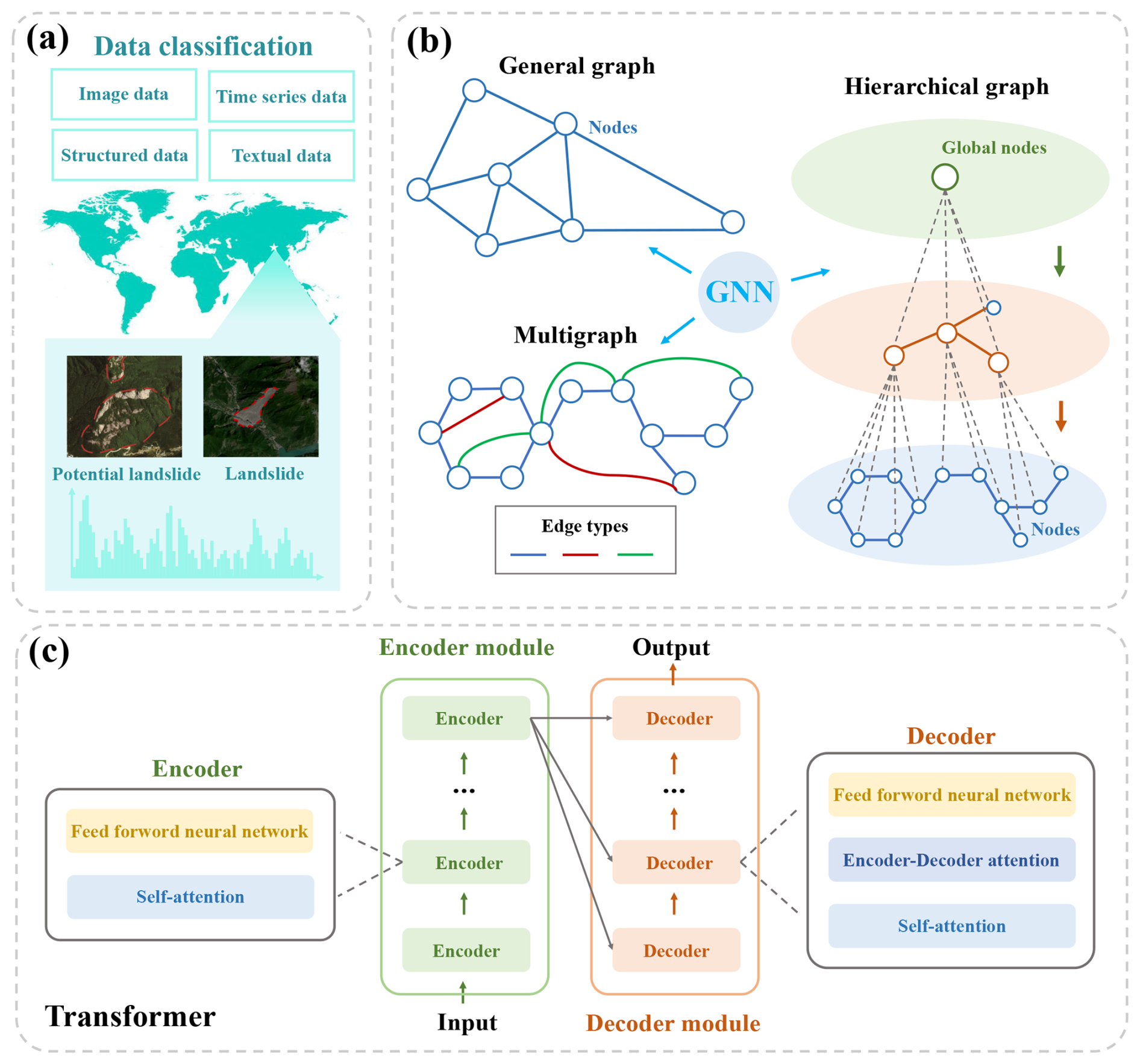
Figure 5Integrated framework of GNNs and Transformers for data fusion. (a) Multi-source integration: the architectural flow for synthesizing heterogeneous datasets (spatial images, time-series, and structured data) to support robust decision-making. (b) Topology modeling: GNN mechanisms designed to aggregate spatial dependencies across general, multi-graph, and hierarchical slope networks. (c) Global contextual attention: the Transformer architecture utilizing self-attention mechanisms to capture long-range dependencies in sequence-based or flattened spatial features.
Conventional data fusion approaches in landslide studies (such as feature concatenation, weighted linear combination, or statistical multivariate analysis) generally rely on predefined assumptions regarding variable independence or linear interactions. While these methods are computationally efficient, they struggle to capture the nonlinear, scale-dependent, and cross-modal relationships that characterize real-world landslide processes. In contrast, deep learning-based data fusion models provide a data-driven means to automatically learn high-order feature interactions across heterogeneous inputs, thereby offering a more flexible and expressive framework for potential landslide identification.
Among existing architectures, Graph Neural Networks (GNNs) have attracted increasing attention due to their ability to explicitly represent non-Euclidean spatial relationships. Landslide-related terrain units (e.g. slope units, grid cells, or monitoring stations) are inherently interconnected through topography, hydrological pathways, and geological continuity (see Fig. 5). Conventional CNN-based fusion models, which operate on regular grids, are limited in capturing such irregular spatial dependencies. By contrast, GNNs represent spatial entities as nodes and their geospatial, hydrological, or geological relationships as edges, enabling the propagation of information across topologically connected units (Scarselli et al., 2008; Ying et al., 2018; Zeng et al., 2022).
In landslide identification and forecasting, this graph-based representation allows geomorphic and hydrological signals to be explicitly transmitted between adjacent or functionally connected units, thereby better reflecting slope interaction mechanisms. For example, Kuang et al. (2022) proposed an innovative landslide forecasting model based on GNNs, in which graph convolutions are employed to aggregate spatial correlations among different monitoring sites. Ren et al. (2025) introduced a novel GNN framework with conformal prediction (GNN-CF) for landslide deformation interval forecasting, addressing the limitations of conventional models in handling predictive uncertainty.
According to the differences in message passing and aggregation methods, GNNs have derived various variants. For example, Graph Convolutional Network (GCN) is generated by generalizing the convolutional operation to graph-structured data (Kipf and Welling, 2016; Sharma et al., 2022; Wang et al., 2020a), and Graph Attention Network (GAT) dynamically weights the importance of neighboring nodes by introducing the attention mechanism (Veličković et al., 2017; Yuan et al., 2022; Zhou and Li, 2021). The emergence of these new architectures makes GNN variants more targeted than conventional GNNs and suitable for modeling heterogeneous relationships. Currently, they are often used for weighted analysis of the impacts of different geographical factors on landslides (Kuang et al., 2022; Li et al., 2025d; Zhang et al., 2024e).
Beyond graph-based models, Transformer architectures have emerged as a unifying framework for multimodal data fusion in landslide studies. As highlighted in Sect. 3.2, the Transformer's self-attention mechanism and modular architecture make it a universal framework for processing sequential data and enabling multimodal fusion (see Fig. 5).
In this context, the core advantage of the Transformer lies in its ability to integrate diverse input data (e.g., satellite imagery, GPS time series, and geological maps). It achieves this by employing independent embedding layers to convert each modality into a unified vector representation, which is then fused through the self-attention mechanism. This mechanism computes the interactions and correlations among all elements across different modalities, thereby enabling the model to capture cross-modal dependencies and extract joint feature representations within a unified framework. This capability makes the Transformer particularly suitable for landslide studies (Li et al., 2025c). For example, Piran et al. (2024) enhanced short-term precipitation forecasting by applying transfer learning with a pre-trained Transformer model. Zhang et al. (2024e) incorporated Transformer modules to build a graph-Transformer model that integrates global contextual information for the generation and analysis of Landslide Susceptibility Maps (LSMs).
In conclusion, deep learning-based data fusion provides a flexible and unified framework for integrating heterogeneous landslide-related data, including spatial, temporal, and topological information. By enabling joint representation learning across multiple data modalities, fusion-oriented architectures such as GNNs and Transformers have substantially enhanced the capability of potential landslide identification to capture complex environmental interactions that cannot be adequately represented by single-source or loosely coupled models. As a result, data fusion has become a critical methodological component in contemporary deep learning-based landslide hazard studies.
The preceding sections have laid the groundwork by discussing the data prerequisites and model architectures fundamental to deep learning in potential landslide research. Building upon that foundation, this section turns to the practical applications of deep learning for identifying potential landslides across diverse real-world scenarios.
Given that landslides are triggered by different dominant factors, the mechanisms, data characteristics, and monitoring strategies vary substantially among different types. To provide a systematic and targeted analysis, this section organizes the applications according to four major triggering categories: rainfall-induced landslides, earthquake-induced landslides, human activity-induced landslides, and multi-factor-induced landslides (see Fig. 6). For each category, we briefly outline its geological characteristics, summarize representative deep learning applications, and discuss model adaptability and monitoring considerations. This structure allows for a comprehensive understanding of how deep learning frameworks can be tailored to the unique challenges posed by different landslide-inducing mechanisms.
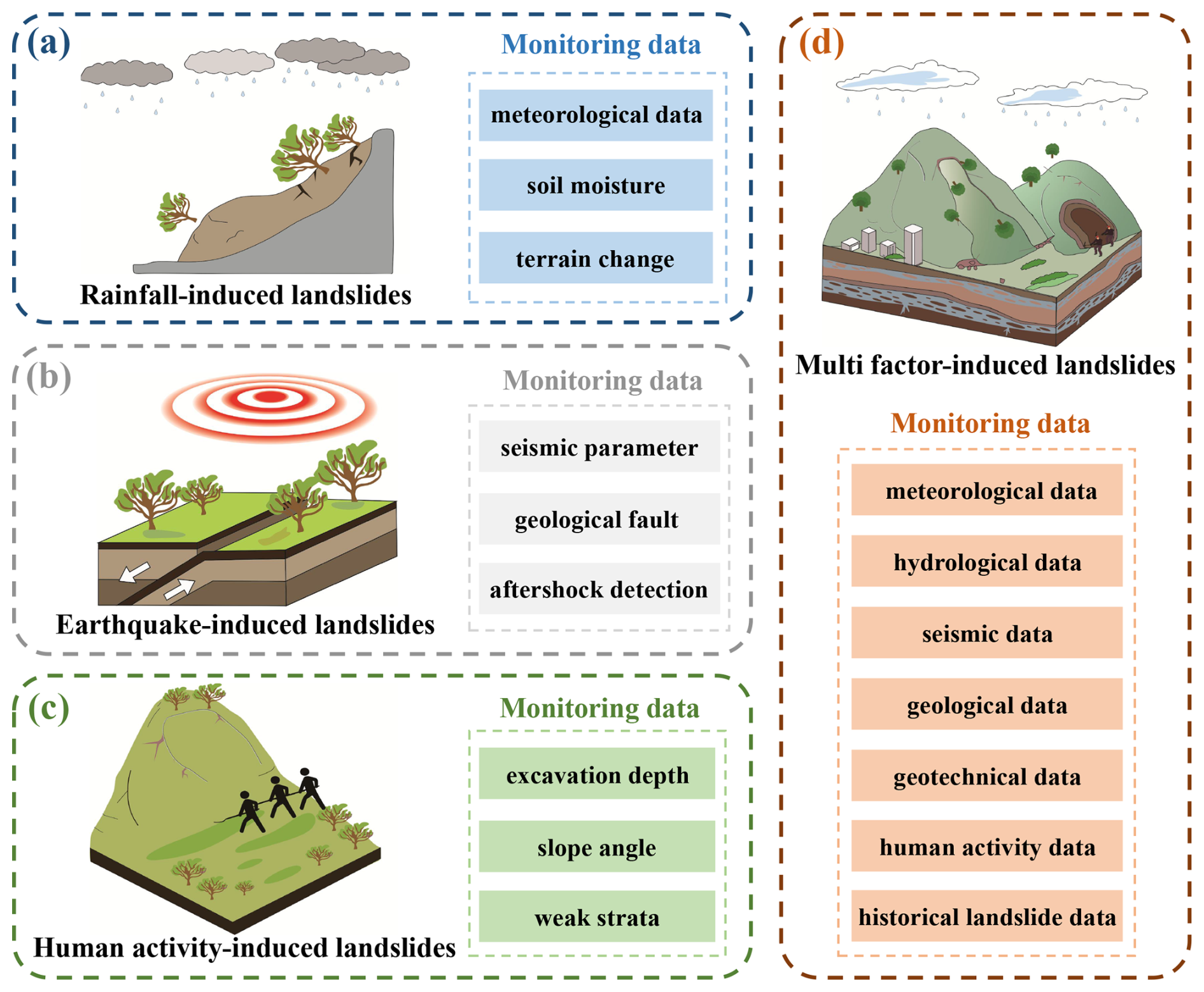
Figure 6Selection of monitoring data for different types of landslides (a) Rainfall-induced landslides. (b) Earthquake-induced landslides. (c) Human activity-induced landslides. (d) Multi-factor-induced landslides.
4.1 Application of Deep Learning in the Identification of Rainfall-induced Landslides
Rainfall stands as the predominant global trigger for landslides. Intense and short-duration rainfall events (lasting from a few hours to several days) often induce shallow landslides (Ma and Wang, 2024), whereas prolonged rainfall (lasting from several weeks to months) can lead to deeper and larger landslides, with depths ranging from 5 to 20 m (Casagli et al., 2023). Consequently, rainfall intensity, cumulative precipitation, and rainfall duration constitute critical triggering parameters for rainfall-induced landslides (Mondini et al., 2023).
Sustained or intense rainfall elevates slope unit weight and moisture content, alters pore water pressure regimes, and reduces shear strength via the principle of effective stress, thereby initiating surface instability. This hydro-mechanical coupling establishes a pronounced positive correlation between rainfall patterns and slope deformation (Li et al., 2022a).
Temporally, landslides exhibit both abrupt failure and delayed responses to rainfall. Pre-existing fractures act as preferential pathways for rainwater infiltration, yet the time required for percolation to reach slip zones introduces a hysteresis effect in slope deformation relative to precipitation events (Jiang et al., 2023; Liu et al., 2022c). During wet seasons, intense rainfall elevates groundwater tables, inducing fully saturated conditions in slope materials. This saturation amplifies shear strain rates, triggering rapid acceleration of landslide movement. Post-rainfall, groundwater levels remain elevated for extended periods (weeks to months), resulting in sustained but decelerated sliding velocities rather than complete stabilization. Consequently, despite concentrated rainfall during wet seasons, numerous landslides occur in subsequent dry periods (Ren et al., 2023), highlighting the delayed destabilization governed by lingering pore pressure dynamics. The hysteresis phase reflects progressive energy accumulation toward critical thresholds, while abrupt failure signifies rapid energy release during instability. This transition is typically characterized by a near-instantaneous shift from stable to unstable states when pore water pressures or soil moisture content exceed critical thresholds, with minimal intermediate deformation phases.
The spatial clustering of rainfall-induced landslides fundamentally arises from the coupling of moisture transport efficiency and geotechnical strength degradation within specific geomorphic units (Wicki et al., 2020; Yu et al., 2021). Spatially, such landslides are concentrated in high-rainfall zones and permeable lithologies, where hydro-mechanical feedback dominates slope destabilization. High-rainfall zones, characterized by frequent and intense precipitation, impose dual hydrological stresses on slopes: surface runoff erodes toe regions, while infiltration elevates pore pressures, collectively acting as external drivers of failure. Highly permeable strata, characterized by high porosity or interconnected fractures, accelerate water migration. Combined with high permeability, these properties regulate water retention time within the slope and control the efficiency of pressure transmission, forming an internal transport network that facilitates landslide progression. The superposition of these mechanisms drives slope stability beyond critical thresholds over short timescales, culminating in abrupt failure.
What determines the critical threshold for rainfall-induced landslides? First, it is essential to define the critical threshold as the minimum amount of rainfall required to trigger a landslide under specific geological and topographic conditions (Naidu et al., 2018; Segoni et al., 2018b). This threshold is typically classified into two types: empirical thresholds, which are derived from statistical relationships between historical landslide events and rainfall data, and physically based thresholds, which incorporate hydromechanical models. Both approaches assume rainfall as the primary destabilizing driver. To operationalize these thresholds for landslide prediction, monitoring systems integrate rain gauge and remote sensing to assess proximity to critical saturation levels (Li et al., 2023a; Piciullo et al., 2018). Moreover, the relationship between rainfall and landslides is often nonlinear and influenced by multiple factors. Deep learning models enable data-driven determination of context-specific critical rainfall values across diverse geological and topographical settings (Sala et al., 2021; Segoni et al., 2018a). For example, Badakhshan et al. (2025) incorporated the role of soil strength. Soares et al. (2022) utilized the U-Net model, reveals that the inclusion of a normalized vegetation index layer enhances model balance and significantly improves segmentation accuracy.
Following the development of rainfall threshold models, real-time monitoring of historically rainfall-induced landslides is imperative. First, continuous surveillance enables early detection of subtle deformations and precursory anomalies (Guzzetti et al., 2020; Zhu et al., 2023b), facilitating timely reactivation warnings to mitigate secondary hazards to lives and infrastructure. Second, by continuously monitoring rainfall, soil moisture, and groundwater levels, we can support dynamic recalibration of threshold parameters. This data assimilation enhances model adaptability to evolving hydrogeological conditions, ensuring operational relevance across heterogeneous terrains.
While the physical mechanisms governing rainfall-induced slope failures have been well studied (Arnone et al., 2011; Xiong et al., 2024), recent advances in deep learning have significantly improved our ability to automatically identify and predict such events using heterogeneous data.
In the context of rainfall-induced landslides, spatiotemporal data (e.g., rainfall intensity, cumulative precipitation, soil moisture, and slope displacement time series) are the primary inputs. Deep learning models are selected according to data characteristics and task objectives. For instance, CNNs are commonly used to extract spatial rainfall-topography features and delineate susceptible zones from remote sensing images (Peng and Wu, 2024; Xu et al., 2022a; Zhang et al., 2022b). The encoder-decoder architecture, such as U-Net, enables pixel-level segmentation of rainfall-induced landslides (Bhatta et al., 2025), with the inclusion of vegetation or soil moisture layers improving feature discrimination.
When temporal evolution is essential, RNNs and LSTMs effectively model sequential dependencies between rainfall and slope deformation (Biniyaz et al., 2022; Liu et al., 2025). These models are capable of learning hysteretic responses and time lags between precipitation events and ground displacement, enabling early warning through time-series forecasting.
Deep learning also facilitates data-driven rainfall threshold estimation. Instead of relying solely on empirical or physically based thresholds, models such as Fully Connected Neural Networks (FNNs) and attention-based transformers can derive adaptive rainfall thresholds from multi-year rainfall-landslide records, capturing regional nonlinearities (Wu et al., 2023).
4.2 Application of Deep Learning in the Identification of Earthquake-induced Landslides
Earthquakes not only trigger landslides during the seismic phase but also increase the susceptibility of post-earthquake landslides by weakening slope materials or forming co-seismic landslide deposits (Zhang et al., 2024a; Zhao et al., 2024a). On the one hand, the seismic vibrations can loosen the structure of the rock and soil mass on the slope, reducing the cementation between particles. The originally intact rock mass may develop cracks, and the density of the soil decreases, thus reducing the overall stability of the slope and making it more prone to landslides after the earthquake. On the other hand, the landslides that have occurred during the earthquake process will generate a large volume of deposits. These co-seismic landslide deposits are usually accumulated at positions such as the lower part of the slope or in valleys. They are in a relatively unstable state themselves, providing a material basis for subsequent re-sliding (Fan et al., 2019; Yao et al., 2024).
So, what is the temporal relationship between earthquake-induced landslides and seismic events? When an earthquake occurs, landslides may be triggered instantaneously by seismic ground motion, typically within seconds to minutes after the earthquake. Such landslides are mainly triggered by the Peak Ground Acceleration (PGA) or Peak Ground Velocity (PGV) of the seismic ground motion (Kargel et al., 2016; Zhao et al., 2023). When these values reach a certain level, they are sufficient to enable the rock and soil masses on the slope to overcome the frictional force and shear strength, thus leading to the occurrence of landslides.
Earthquake-induced landslides are typically concentrated in areas of high seismic intensity, particularly on steep slopes or within loose accumulations (Li et al., 2024b). A fault is a place where the rocks in the earth's crust break and undergo relative displacement. Its existence destroys the continuity and integrity of the rock mass, making it more prone to deformation and damage under the action of seismic forces. On the hanging wall of a reverse fault, the compressive force usually causes the rock blocks to break, and mountain landslides are likely to occur during seismic events. In contrast, on the footwall of a normal fault, the tensile force may cause the rock blocks to fracture and loosen, thus increasing the risk of mountain landslides.
The Newmark model is a commonly used basic model in the research of earthquake-induced landslides (Jibson, 2007; Newmark, 1965). Based on a simplified assumption, it regards the rock and soil masses on the slope as rigid blocks. When these rigid blocks are affected by seismic vibrations, they slide on the slope surface. By calculating the cumulative downhill displacement of the rigid blocks caused by the continuous increase of seismic vibrations, the stability of the slope under the action of an earthquake is measured. In other words, the greater the cumulative downslope displacement, the more unstable the slope is during the earthquake, and the higher the likelihood of a landslide occurring. However, Newmark's model exhibits critical limitations: (1) dependence on oversimplified soil or rock strength assumptions, and (2) inadequate integration of high-resolution seismic motion data. Deep learning models address these gaps by processing massive real-time datasets, filtering noise from obscured remote sensing imagery (Wang et al., 2024e), and fusing seismic parameters with multispectral satellite data through cross-modal architectures (Dahal et al., 2024).
Within hours to days post-main shock, aftershocks can further destabilize already loosened slope structures, triggering secondary landslides clustered near co-seismic failure zones or aftershock epicenters (Sun et al., 2024b; Zhang et al., 2024c). These landslides are often concentrated around the mainshock-induced landslide bodies or the epicentral region of aftershocks, potentially forming disaster chains (e.g., landslides blocking rivers, leading to the formation and subsequent failure of landslide dams, which may trigger flooding). Even years post-earthquake, relic landslide deposits may reactivate through gradual creep or extreme climatic forcing, necessitating long-term spatiotemporal monitoring and dynamic risk reassessment (Jones et al., 2021; Li et al., 2021c). Moreover, earthquake-induced landslides are often associated with complex 3D topographic changes, which are difficult to capture using conventional 2D analyses. Deep learning frameworks enable precise reconstruction of landslide geometries by processing LiDAR-derived or UAV-derived 3D point clouds, capturing volumetric deformation patterns critical for mechanistic modeling.
Current applications of deep learning in earthquake-induced landslides primarily focus on semantic segmentation and change detection (Chowdhuri et al., 2022; Huang et al., 2023b; Liu et al., 2020a; Yang et al., 2024b). Liu et al. (2021b) employed Graph Isomorphism Networks (GIN) to model long-range dependencies among high-level features extracted by ResNet-50. Zi et al. (2021) utilized a hybrid architecture combining GATs and channel self-attention mechanisms enhances the modeling of feature interdependencies from ResNet-50. Yang et al. (2023b) incorporated a spatial attention module to capture contextual dependencies and extract rich non-local spatial features, proposing a novel semantic segmentation network, EGCN, to enhance landslide recognition accuracy.
Both physics-based and data-driven model calibration rely on earthquake-induced landslides inventories (Bhuyan et al., 2023; Tanyaş et al., 2017). Despite increased inventory availability, persistent issues of representativeness and completeness limit model generalizability and mechanistic fidelity.
4.3 Application of Deep Learning in the Identification of Human Activity-induced Landslides
Human activity-induced landslides typically arise unintentionally during construction activities, where initial slope equilibrium is disrupted by slope toe excavation or water infiltration into exposed fractures (Zhao et al., 2022). Compared to natural landslides, human activity-induced failures are often more controllable, underscoring the critical importance of pre-disaster identification for risk mitigation. These landslides are characterized by localized micro-deformation and subsurface disturbances, necessitating integrated monitoring systems that combine high-resolution remote sensing data with ground-based sensors for early anomaly detection.
Current predominant anthropogenic triggers include mining and loading (Ma et al., 2023a; Xu et al., 2022b). These activities induce severe surficial damage, with stratigraphic movement and surface deformation leading to the formation of ground fissures. Such fissures compromise surface ecosystems and vegetation, while also penetrating subsurface mining cavities, posing grave risks to operational safety. Consequently, deep learning models are essential for automated ground fracture extraction to enable real-time hazard mapping and preventive interventions (Huangfu et al., 2024).
Moreover, the triggers of human activity-induced landslides are not only related to natural conditions but also closely associated with dynamic human activities. Consequently, their analysis necessitates the integration of multimodal and cross-scale data to capture coupled environmental and behavioral drivers (see Fig. 6). In engineering operations such as mining or road construction, factors including proximity to potential landslide zones, excavation depth, and slope angles must be rigorously evaluated through geohazard risk assessments. During excavation phases, geotechnical investigations are imperative to identify weak lithological strata or fracture-dense zones predisposed to instability. Continuous slope stability monitoring requires deploying IoT-enabled sensors to track temporal variations in surface fissure dimensions and subsurface displacement vectors. Monitoring data from these sensors can be integrated into deep learning models for multimodal analytics, enabling dynamic risk prediction and adaptive mitigation planning.
For spatial mapping and fissure extraction, CNNs and U-Net-based segmentation models have demonstrated strong capability in identifying artificial slope features from optical or SAR imagery. CNN-based models can capture high-level semantic information on excavation scars, road cuts, and spoil heaps that indicate anthropogenic disturbance. Tao et al. (2024) employed the DRs-U-Net model to investigate the use of deep learning for UAV-based crack identification, the developmental patterns of fissures, and the feedback interactions between underground mining progress and corresponding surface conditions. Wu et al. (2021) proposed the PU-Net model for detecting and mapping localized rapid subsidence induced by mining activities. Meng et al. (2025) introduced the GF-Former model to achieve precise segmentation of ground fissures in remote sensing imagery.
When surface deformation time series or micro-displacement data from GB-InSAR, InSAR, or IoT sensors are available, RNN-based models are applied to model the temporal evolution of slope deformation (Han et al., 2022; Li et al., 2025a). These models are particularly effective in detecting precursory motion trends caused by progressive excavation or loading activities.
To mitigate misclassification between anthropogenic signatures and natural terrain, integrating multispectral data with topographic elevation data enhances discriminative capacity (Meng et al., 2021; Selamat et al., 2023). For instance, in mountainous regions, DEMs revealing artificially excavated steep slopes combined with fractured geological strata from structural maps provide preliminary evidence of human influence on landslide susceptibility (Lian et al., 2024).
In fact, landslides induced solely by human activities are relatively rare. Single human activities are typically insufficient to independently trigger landslides, with natural factors often acting in conjunction with human activities. Furthermore, the prohibitive cost of acquiring subsurface disturbance data results in sparse historical landslide samples for specific engineering scenarios, limiting data-driven model training.
4.4 Application of Deep Learning in the Identification of Multi-factor-induced Landslides
Multi-factor-induced landslides result from the synergistic interaction of multiple natural and anthropogenic factors (Hao et al., 2023). Their triggering mechanisms involve the dynamic spatiotemporal coupling of these factors, driving progressive destabilization of geomaterials through cumulative strength degradation. The formation of such landslides may involve various types of movements, including collapse, creep, and flow phenomena. They often exhibit characteristics such as complexity, nonlinearity, and suddenness. Therefore, their identification is markedly more complex compared to landslides induced by singular factors.
Unlike simpler landslide types, identifying composite landslides necessitates multimodal data fusion to holistically assess predisposing conditions (Li, 2025; Yin et al., 2023). It further requires disentangling the nonlinear superposition effects of multiple factors and quantifying their relative contributions to failure initiation.
In multi-factor-induced landslides, earthquakes and rainfall often interact with other factors (Dou et al., 2019). During heavy rainfall, the rate of landslide formation after an earthquake may be higher, possibly driven by the removal of excessively steep slopes, changes in vegetation and groundwater, and alterations in the mechanical properties of the bedrock and weathered layers in the earthquake-induced landslides canopy. This necessitates systematic investigation of multi-hazard coupling effects to quantify emergent risks.
In addition to constructing physics-based models that account for multiple factors and quantify their interactions through the solution of governing equations, GNNs can also be employed (Lei et al., 2025). These models are capable of capturing the spatiotemporal dependencies and nonlinear couplings among various triggering factors. For example, Ren et al. (2025) employed a GNN to capture and model the complex spatiotemporal dependencies among multiple monitoring locations during landslide deformation. Zeng et al. (2022) used the graphical representation capability of the GNN model to analyze environmental relationships within a study region, where nodes were defined as geographic units delineated by terrain surface approximations, and edges captured the interactions between node pairs. Zhang et al. (2024d) constructed a geographically constrained relational graph based on node features representing environmental similarity and employed a cosine similarity approach to associate landslides with their surrounding geographic environments.
Cross-attention mechanisms can also be integrated into the model to capture spatiotemporal dependencies among contributing factors. For instance, Hu et al. (2025a) integrated global landslide feature vectors with local feature maps through a cross-attention mechanism to enhance the discriminative capability between landslides and background geomorphology. Another noteworthy fusion strategy is the gated fusion unit. Inspired by the gating structures in recurrent neural networks (Arevalo et al., 2017; Kumar and Vepa, 2020; Tsai et al., 2019), this mechanism learns dynamic weights (typically implemented through gating functions such as Sigmoid) to adaptively regulate the information flow of features from different modalities, thereby emphasizing salient features and suppressing noise. Compared with cross-attention, the gated fusion mechanism is generally more lightweight and provides an alternative approach for multimodal feature fusion (Yang et al., 2024a). For instance, Liu et al. (2022a) proposed a gated fusion unit module for multimodal remote sensing image semantic classification, enabling early fusion of heterogeneous modality features.
With the accumulation of new data and the dynamic variations in multi-factor-induced landslides, regular model updates are critical to ensuring identification accuracy and adaptability. Existing studies predominantly apply deep learning methods based on comprehensive historical landslide datasets. However, when new data becomes available, a naive approach is to retrain the model from scratch, which is computationally inefficient and fails to capture the connections between new observations and historical knowledge. A common strategy from the machine learning literature to address this is fine-tuning, where a model pre-trained on a historical dataset is further trained on new data (Süalp and Rezaei, 2025). While this avoids full retraining, standard fine-tuning can still lead to catastrophic forgetting of previously learned patterns.
Table 1Typical correspondences among data source, deep learning models, and applications in potential landslide identification
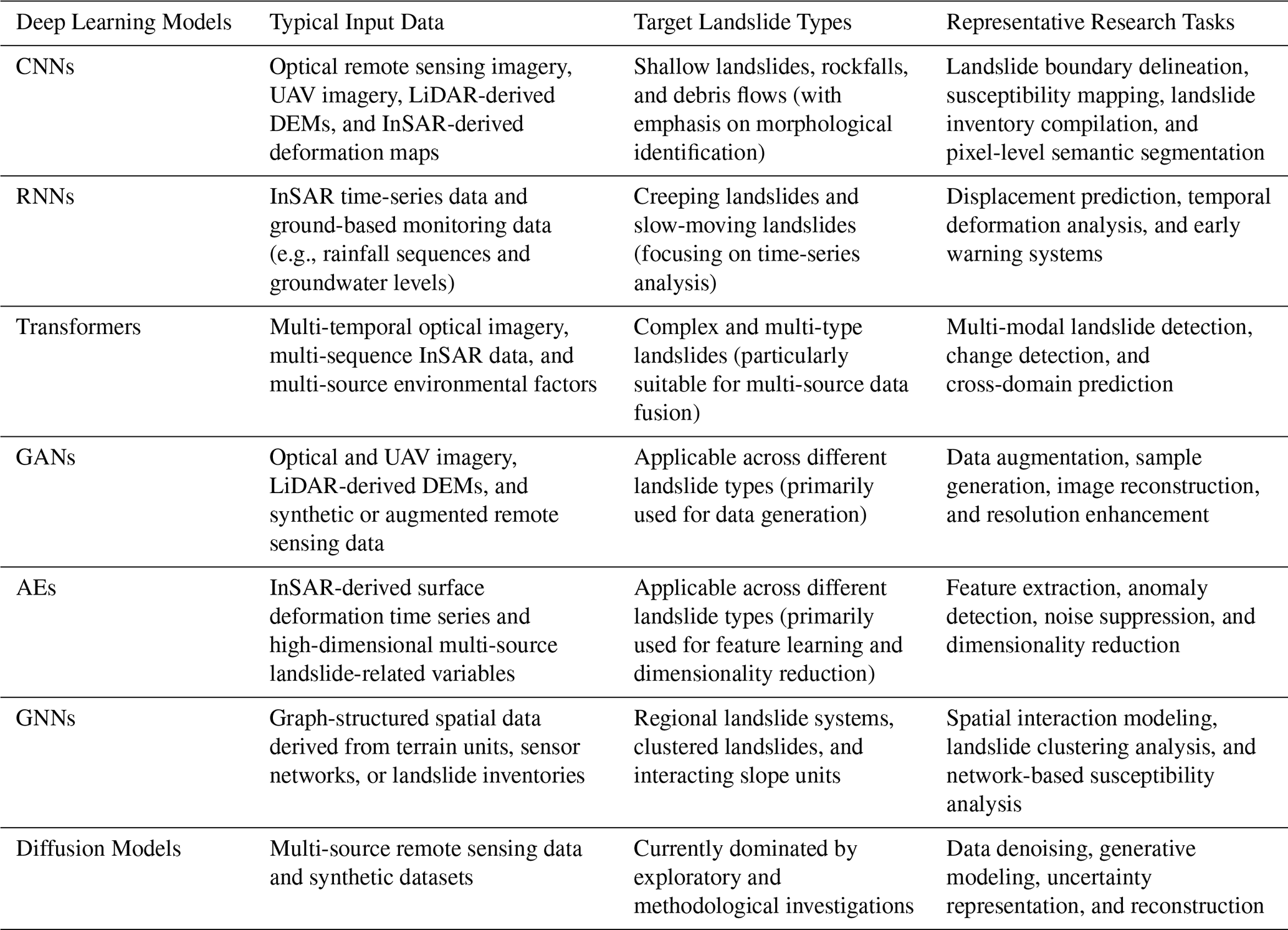
To better accommodate the dynamic nature of landslides, incremental learning methods offer a more advanced and promising solution (Huang et al., 2022a; Wang et al., 2024c). These methods enable the model to continuously learn from new data streams, gradually optimizing parameters while striving to preserve knowledge from previous tasks. Compared to models that require retraining or basic fine-tuning (Zhao et al., 2024c), models integrated with incremental learning can more effectively leverage historical data and adaptively incorporate new information, thereby enhancing long-term adaptability (Zhen et al., 2025).
The diverse applications discussed in this section demonstrate that the selection and effectiveness of a deep learning model are fundamentally governed by the interplay between available data types, inherent model capabilities, and specific task objectives. To synthesize these critical relationships and provide a clear reference framework, Table 1 maps the typical correspondences between predominant deep learning architectures, their compatible data source, suited landslide phenomena, and representative application tasks. This synthesis underscores that there is no universally optimal model; rather, a strategic alignment across the data-model-application pipeline is key to successful implementation.
4.5 Summary on the Applications of Deep Learning for Potential Landslide Identification
In general, the process of the applications of deep learning for potential landslide identification involves data collection, preprocessing, model construction, training, and validation, followed by deploying the trained model to identify potential landslides. Variations arise in data sources, trigger mechanisms, and model handling approaches specific to each landslide type. For rainfall-induced landslides, the model prioritizes rainfall-related data, with particular emphasis on simulating rainfall infiltration effects. Earthquake-induced landslides require prioritization of seismic data, including earthquake magnitude and post-seismic geological alterations. Human activity-induced landslides demand focused analysis of the relationship between engineering activities and geological changes. In contrast, multi-factor-induced landslides necessitate models that integrate multiple triggering mechanisms and perform a comprehensive assessment of the cumulative effects of diverse contributing factors.
Whether landslides are triggered by rainfall or earthquakes, gravity remains the dominant driving force (She et al., 2024). The primary role of triggering factors lies in reducing slope stability or amplifying gravitational effects. Before and during landslide occurrence, deformation of slope geomaterials constitutes the most observable phenomenon (Zhou et al., 2025). This deformation often manifests as the formation and expansion of cracks.
Since landslide deformation is a dynamic process, ranging from initial minor changes to eventual large-scale sliding, each stage exhibits distinct characteristics. Therefore, landslides can be classified into distinct stages based on their deformation characteristics, enabling more accurate identification of impending disaster warning signals (Zhang et al., 2024b). Here, we categorize landslide evolution into three phases: (1) creep deformation stage, (2) intermediate development stage, and (3) progressive failure stage (see Fig. 7).
In the creep deformation stage, the slope gradually deforms under the influence of various factors, though surface manifestations may not be readily observable. Small, discontinuous cracks with limited width may emerge on the slope surface or crest. High-precision measuring instruments can detect localized minor displacements or deformations (Zhan et al., 2024). Vegetation on the slope may exhibit tilting or leaning patterns, with tree orientations potentially aligning in consistent directions. In the intermediate development stage, slope deformation progresses at a relatively stable rate. Initially observed surface cracks gradually widen and elongate, eventually interconnecting to form larger fracture networks. Crack widths may expand from a few centimeters to tens of centimeters or more, accompanied by displacement between soil or rock blocks. Monitoring systems can record slope displacements at a relatively constant rate. Slope deformation disrupts pre-existing groundwater flow paths, resulting in alterations to groundwater levels, volume, or quality within the landslide mass and surrounding areas. The progressive collapse stage predominantly reflects pre-sliding slope deformation characteristics and is critical for identifying imminent landslides (Cascini et al., 2022; Chen et al., 2024b). In progressive landslides, the potential sliding surface gradually evolves into a continuous failure plane. In sudden landslides, due to their abrupt evolutionary process, no distinct sliding surface is evident, making it necessary to rely on other indicators for identification. Physical phenomena such as crack widening and deepening, formation of enclosed boundaries by cracks and drainage holes, increased displacement at the rear edge of the slope, bulging at the slope's toe, increased seepage at the slope foot, an increase in slope angle, and reverse tilting of the slope collectively aid in identifying potential landslides.
Theoretically, the unique identification markers of each stage can serve as input features for deep learning models, enabling direct classification of landslides into distinct stages. This facilitates the implementation of more targeted mitigation measures for each stage. Since slope changes ultimately result from displacement variations, we propose that a landslide identification method based on deformation characteristics as indicative factors holds great potential.
After classifying landslide stages based on deformation characteristics, different mitigation strategies should be applied to each phase. In the creep deformation stage, the focus should be placed on landslide triggering factors, with risk reduction measures such as drainage systems and slope cutting. In the intermediate development stage, monitoring should be intensified alongside temporary reinforcement measures. In the progressive collapse stage, emergency evacuation and stabilization of the potential landslide mass must be prioritized.
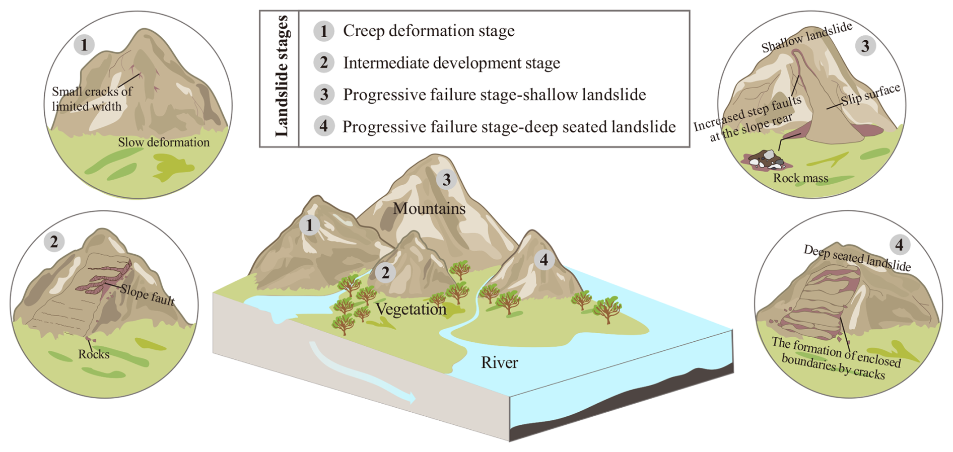
Figure 7The development of landslides is divided into three stages with distinctive identification markers.
5.1 Data Quality and Availability
In potential landslide identification, the performance of deep learning models is critically dependent on both data quality and availability (Alzubaidi et al., 2023; Gaidzik and Ramírez-Herrera, 2021; Whang et al., 2023). Low-quality or unreliable data directly impair the models' feature extraction capabilities, while insufficient data availability constrains their generalization capacity and real-time monitoring efficacy (Azarafza et al., 2021; Xiao and Zhang, 2023).
In the natural environment, non-landslide states are the norm, while the landslide state is relatively rare (see Fig. 8). This leads to the data collected mainly consisting of normal geological conditions, with much less data representing potential landslides. Such a severe skewness in the class distribution results in a serious imbalance in the data, that is, there is a huge difference in quantity between the minority class (landslide samples) and the majority class (non-landslide samples) (Jiang et al., 2024). Gupta and Shukla (2023) demonstrated that this data imbalance can cause learning algorithms to be biased towards the majority class, perform poorly on the minority class. This bias impedes the predictive ability of the learning algorithms, and ultimately lead to the final model's poor performance in identifying and predicting the minority class of landslide samples.
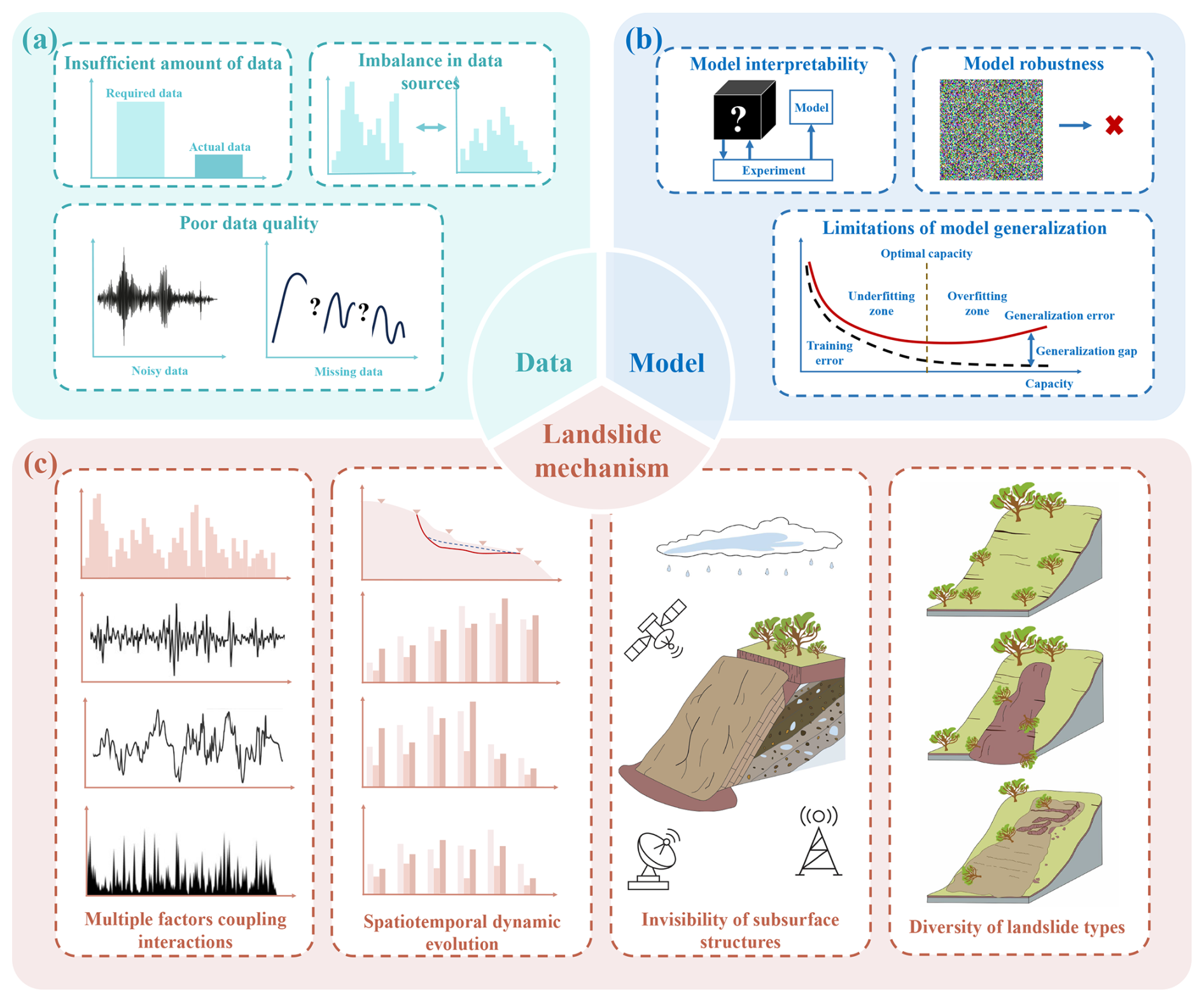
Figure 8Challenges of deep learning in potential landslide identification. (a) Data quality and availability. (b) Limitations of deep learning models. (c) Complexity of landslide mechanisms.
Even if some landslide inventory data have been collected, it is often difficult for these data to represent the real landslide situations within the study area. There may be issues such as omissions and biases, which greatly reduce the credibility of the results derived from these data (Woodard and Mirus, 2025; Zêzere et al., 2017).
The presence of irrelevant input dimensions within the data necessitates larger training datasets for deep learning models to achieve satisfactory generalization performance. This can be attributed to the models' tendency to overfit to noise or spurious patterns within extraneous features, thereby failing to capture task-relevant characteristics. Such overfitting diminishes adaptability to unseen data, reduces prediction accuracy, and ultimately degrades data efficiency (D'Amario et al., 2022). As a result, deep learning models may exhibit inaccurate recognition or even failure when confronted with novel, complex scenarios outside the training distribution.
Different types of features vary in terms of data format, dimensions, and semantics, posing a key challenge in achieving high-level feature fusion for complementary and synergistic information integration (Liu et al., 2023b). For example, different sensor data exhibit significant differences in physical meaning and data structure (Ghorbanzadeh et al., 2022a). Optical imagery (RGB matrices) reflects surface coverage but is susceptible to cloud interference. SAR data (complex phase) can capture deformation information but contains speckle noise. LiDAR point clouds (3D coordinates) provide high-precision terrain data but have limited coverage. Ground sensors (temporal scalars) enable real-time monitoring of subsurface parameters but are spatially sparse. Direct fusion of such multi-modal data induces feature space incompatibility, hindering cross-modal correlation extraction (Cai et al., 2021; Jin et al., 2022). Zhang et al. (2023) highlights that even remote sensing data exhibits high heterogeneity in imaging mechanisms, illumination conditions, and spectral characteristics.
Furthermore, multiple types of heterogeneous data will increase model complexity, potentially leading to prolonged training times, excessive computational demands, and overfitting risks. Simple combination of low-level detail features with high-level semantic features may introduce contextual noise, compromising feature robustness and semantic coherence (Ji et al., 2020). When designing densely connected convolutional networks, a balance must be struck between model complexity and generalization capacity to mitigate overfitting on training data and ensure robust performance on unseen scenarios (see Fig. 8).
5.2 Limitations of Deep Learning Models
Although deep learning models have achieved success in landslide identification (Meena et al., 2022; Su et al., 2021; Yi and Zhang, 2020), they are plagued by several inherent limitations. Among these, the most critical challenge is their lack of interpretability (Li et al., 2025e), which refers to the difficulty in explaining the internal decision-making processes behind their predictions.
Deep learning architectures typically contain a large number of parameters and layers, making it challenging to intuitively interpret their internal weights and feature representations. It is often unclear whether the model's predictions are based on key geological features (e.g., slope gradient, lithological structure, fracture distribution) or influenced by irrelevant factors such as vegetation color or image noise. In potential landslide identification, a common issue is that models may mistakenly classify shadows or cloud cover as potential landslides, yet the underlying causes of such misclassifications remain opaque. When multimodal data are integrated for landslide detection, it is also challenging to clarify how the model weights different data sources.
The abstract features extracted by these models also lack a clear correspondence to interpretable geological indicators (see Fig. 8). Even when the model successfully identifies potential landslides based on texture patterns in remote sensing imagery, it remains unclear whether these patterns correspond to actual geomechanical parameters or physical processes.
Moreover, the probability values output by the models often lack physical meaning and therefore cannot effectively represent geological uncertainty. In practice, high-risk areas predicted by the model may conflate “uncertainty caused by data absence” with “risk of the geological conditions themselves” (Achu et al., 2023; Feng et al., 2022). Even experienced geologists may struggle to validate the geological plausibility of such features, thereby constraining the adoption of deep learning results in practical engineering applications.
Compounding these issues, there also exists an inherent inconsistency between data-driven feature learning and the complexity of real-world geological processes. Deep learning models tend to capture superficial statistical patterns rather than the governing physical mechanisms that are generalizable across different regions and environmental conditions. Consequently, in potential landslide identification, substantial manual annotation efforts are often required when transferring models across regions or sensors.
Despite the availability of diverse datasets, the lack of standardized, high-quality annotated benchmarks has severely hindered the development and fair comparison of deep learning models (Fang et al., 2024). Current models are often trained and validated on independent, task-specific datasets, thereby preventing an objective assessment of state-of-the-art performance and limiting our ability to evaluate their true generalization capacity across varying geological settings and triggering factors.
5.3 Complexity of Landslide Mechanisms
5.3.1 Multiple Factors Coupling Interactions
The formation of landslides involves the dynamic coupling of multiple factors such as geological structures, geotechnical mechanics, hydrological conditions, topography, meteorological factors, vegetation coverage, and human activities (Scheingross et al., 2020; Yi et al., 2022). Therefore, the triggering mechanisms are inherently multiscale, ranging from microscopic interparticle friction to macroscopic slope instability, and encompassing both transient dynamic responses and long-term temporal evolution (see Fig. 8).
For example, geotechnical materials and structural features of the geological setting influence soil stability, while hydrological factors such as rainfall infiltration and groundwater fluctuations alter soil mass properties, critically weakening shear strength due to pore pressure variations. Extreme meteorological events can alter slope stress regimes, while topographic parameters define geomorphic susceptibility thresholds. Human activities further influence slope stability. The interactions among these factors are highly nonlinear and temporally variable, making them difficult to characterize through simple mathematical formulations.
This implies that variations in individual factors may induce cascading effects rather than linear responses. For example, rainfall-induced landslides exhibit threshold-dependent behavior governed by coupled hydro-mechanical processes. When rainfall intensity or duration exceeds critical thresholds, the rapid rise of the groundwater table increases pore water pressure, thereby reducing effective stress and weakening shear strength according to the principle of effective stress. Such hydro-mechanical feedback often culminates in abrupt slope failure.
5.3.2 Spatiotemporal Dynamic Evolution
The inducing factors of landslides are not only extremely complex in spatial distribution but also highly dynamic in terms of time (Gao et al., 2023). This variability makes the research process of the landslide mechanism more difficult.
From the perspective of temporal dynamics, landslide formation is not instantaneous but evolves through prolonged stages, each governed by distinct mechanisms (see Fig. 7). This dynamic progression across different timescales creates a fundamental modeling challenge: since the numerical simulation of long-term creep requires a long-time step, while the dynamic process of short-term abrupt changes requires a time resolution in the microsecond level, it is difficult to establish a unified model for these two situations. This will further intensify the conflict of time scales.
In terms of spatial heterogeneity, the influence scope of landslides usually involves geological structures ranging from the microscopic structure of geotechnical particles to the regional scale. Moreover, there are differences in the stratum structure, slope morphology, vegetation coverage, water content, which makes the effects of the same inducing factor vary in different regions. For example, in loose soil layers, heavy rainfall may lead to shallow landslides, while on rocky slopes with well-developed joints, earthquakes or water level fluctuations may trigger deep-seated landslides.
Through the interaction of factors at different temporal and spatial scales, positive or negative feedback affects the evolutionary trend of landslides, making the triggering, evolution and reactivation of landslides more complex and increasing the uncertainty of prediction (Huang et al., 2022b; Li et al., 2023b).
5.3.3 Invisibility of Subsurface Structures
Landslide occurrence is intrinsically linked to subsurface structures. However, due to their invisibility, obtaining comprehensive geological information directly is challenging, adding significant complexity to the study of landslide mechanisms (Li et al., 2021d).
The occurrence of landslides is not merely linked to surficial phenomena but more critically governed by subsurface geological structures and hydrogeological characteristics. Subterranean features such as faults and folds directly influence the mechanical properties and stability of rock and soil masses. However, the inherent opacity of subsurface systems limits the accuracy of delineating these structures' spatial distribution, scale, and orientation through surface surveys or sparse borehole sampling, often yielding fragmented insights. Groundwater dynamics play a critical role in modulating slope stability. Fluctuations in the water table alter pore water pressure and effective stress within geomaterials, leading to a reduction in shear strength according to the principle of effective stress. Yet, direct monitoring of hydraulic head variations is inherently challenging, particularly in heterogeneous subsurface environments where localized aquifers exhibit divergent responses to hydrological forcing. Despite advancements in geophysical imaging and hydrological monitoring, the structural anisotropy and permeability heterogeneity of subsurface formations perpetuate ambiguities in mechanistic interpretations, risking oversights in landslide hazard assessments.
The invisibility of subsurface structures makes it difficult to monitor the specific processes and critical points of these dynamic changes in real time. Consequently, researchers can only infer these processes based on surface manifestations or limited monitoring data. This results in ambiguity and uncertainty in the analysis and interpretation of acquired indirect data. Even when model outputs exhibit qualitative agreement with field observations, the validity of underlying assumptions and parameterizations cannot be definitively verified.
5.3.4 Diversity of Landslide Types
Landslides exhibit considerable typological variation, with distinct instability mechanisms and evolutionary pathways governed by geological settings, triggering factors, and kinematic behaviors. Based on material composition, landslides can be classified into rock landslides, soil landslides, debris flow landslides, and composite landslides, each exhibiting distinct variations in physical properties as well as failure modes (McColl and Cook, 2024; Yu et al., 2024). For instance, rock landslides dominated by brittle fracture differ fundamentally from soil landslides governed by plastic shear. Kinematic categorization further distinguishes translational sliding, toppling, creep, and flow-like movements, each involving divergent mechanical processes and triggering thresholds (Shu et al., 2021).
Due to the diversity of landslide types, with each type having different characteristics and influencing factors, it is very difficult to establish a universal research model for the mechanism of landslides. For different types of landslides, corresponding models need to be established according to their specific characteristics and main influencing factors (Milledge et al., 2022). This not only requires a large amount of on-site observation data and experimental research to determine the model parameters, but also requires consideration of the applicability and limitations of the models.
Furthermore, cross-typological interactions among landslides amplify predictive challenges. For example, collapsed debris may transition into debris flows, a process that is governed by hydromechanical coupling and granular-fluid dynamics. Such multi-typological and multi-process couplings resist comprehensive characterization via single-theory frameworks. Instead, they necessitate multi-scale numerical simulations to accurately reproduce the entire process. Consequently, the diversity of landslide phenomena requires interdisciplinary integration across solid mechanics, fluid dynamics, and multi-physics couplings. This task substantially increases the dimensionality and complexity of mechanistic studies, demanding hybrid modeling frameworks and cross-domain validation protocols.
6.1 Multi-source Data Fusion
Different methods specialize in identifying specific types of landslides, and no single method can address all potential landslide types. Therefore, research on potential landslide identification should gradually shift from using single-source data toward multi-temporal, multi-source integrated analysis (Chen et al., 2023b; Ge et al., 2022; Xu et al., 2021).
Multi-source data can comprehensively represent complex influencing factors by integrating various datasets, thereby enhancing information completeness. For instance, topographic and geological data reveal slope stability, remote sensing captures surface deformations, meteorological and hydrological data describe triggering conditions, and ground monitoring provides high-precision dynamic information. Integrating these data enables the construction of a complete feature system covering landslide-causing factors, prone environments, and inducing conditions, while avoiding the one-sidedness inherent to single-source observations.
In the identification of potential landslides, multi-source data fusion specifically refers to the integration of raw data from different sources before feature extraction. Each data source has unique strengths in resolution, coverage, and observation scale, and their fusion achieves complementarity and cross-verification (Liu et al., 2020b; Wang et al., 2021a). For example, combining satellite and UAV data allows both large-scale screening and detailed crack detection (Xia et al., 2021), while merging geological surveys with InSAR time-series deformation distinguishes stable slopes from creeping zones. This cross-validation effectively reduces noise and misjudgment caused by data uncertainty.
Integrating multi-source data fusion with deep learning enables the coupling of data and model advantages (Chen et al., 2023a; Zheng et al., 2021). The fusion reduces uncertainty through comprehensive data representation, while deep learning extracts nonlinear features and captures hidden correlations. Together, they improve the accuracy of potential landslide identification and promote a shift from experience-driven to intelligence-driven hazard monitoring. In the future, the development of cross-modal pre-trained models and edge intelligence will further enhance real-time early warning and hazard simulation, forming the backbone of an integrated “aerial-space-ground-subsurface” monitoring framework.
To advance this paradigm, we advocate for a community-driven benchmark that embodies the multi-modal philosophy. Such a benchmark should include co-registered data from optical, SAR, LiDAR, DEM, and ground-based sensors, reflecting the integrated monitoring reality. Establishing this benchmark is a crucial step toward translating data fusion capabilities into reliable and reproducible AI solutions for global landslide risk reduction.
6.2 Model Ensemble
Model performance depends significantly on the nature of tasks, data characteristics, and specific requirements. Despite its ability to capture specific feature dimensions, a single deep learning model is susceptible to limited generalization, model bias, and overfitting when confronted with data noise and scene heterogeneity (Kavzoglu et al., 2021; Lv et al., 2022). Given these differences, model ensemble provides an effective approach to optimization and generalization.
In the identification of potential landslides, model ensemble essentially achieves a synergistic effect through the aggregation of diversity. While avoiding the limitations and vulnerabilities of individual models, it also unleashes the complementary potential of multiple models through designed mechanisms (Zhou et al., 2022).
This approach can be implemented through several pathways. Feature-level integration involves processing different data features with specialized models and fusing the results. A more common tactic is heterogeneous model combination, which refers to combining various types of models to improve the accuracy of potential landslide identification. Each model can exert its advantages in different feature spaces (Fang et al., 2021), thus forming a powerful predictive combination. A prominent example is the CNN-LSTM hybrid, which capitalizes on CNNs' spatial feature extraction and LSTMs' temporal dependency modeling, making it particularly suited for rainfall-terrain coupled landslide prediction (Gao et al., 2024). Furthermore, advanced architectures like stacking enable deeper model coupling. For instance, Guo et al. (2024) employed a stacked framework integrating 1D-CNN, RNN, and LSTM to form a CRNN-LSTM ensemble, achieving significant performance gains.
Therefore, model ensemble is not a mere technical aggregation but a systematic solution to core challenges like poor generalization, feature bias, and learning from small samples. It transforms the local advantages of multiple models into a global optimum at the system level, achieving comprehensive breakthroughs in identification accuracy and engineering applicability. It is important to note, however, that these performance gains come with increased computational cost and complexity, a necessary trade-off in practice.
6.3 Knowledge-data Dually Driven Paradigm for Potential Landslide Identification
Conventional knowledge-driven methods, grounded in physical mechanics, rely on precise prior knowledge of geological structures and hydrological conditions. However, landslides are influenced by complex, coupled multi-factor interactions, characterized by high parameter uncertainty, making it challenging to comprehensively address such scenarios (Roy and Saha, 2019). Purely data-driven approaches, though capable of extracting patterns from massive datasets, lack physical interpretability, are susceptible to noise interference, and struggle to establish causal relationships in prediction outcomes (Qi et al., 2024). A critical challenge and opportunity, therefore, lies in bridging the gap between data-driven predictive capabilities and a physically interpretable understanding of landslide processes.
To bridge this critical gap, a fundamental shift towards a knowledge-data dually driven paradigm is imperative. This paradigm moves beyond simple combination to a deep integration, where physical principles actively constrain and inform the deep learning architecture. Future research should focus on developing novel frameworks capable of explicitly incorporating landslide typologies and physical laws. For instance, Physics-Informed Neural Networks (PINNs) can embed governing equations directly into the model's loss function, while knowledge graphs can structurally represent the complex relationships between predisposing factors and failure mechanisms.
This synergy, aligned with future concepts like “digital twin” and “smart Earth”, establishes a closed-loop “theory-practice” verification mechanism (Chen et al., 2024c; Das et al., 2024; Huang et al., 2023a; Riahi et al., 2022; Sukor et al., 2019; Zhao et al., 2024e). The ultimate goal is to advance landslide identification from mere pattern recognition towards physically interpretable, causally-aware forecasting, thereby transforming geological hazard mitigation from passive response to proactive prevention.
The overall workflow of this knowledge-data dually driven paradigm for potential landslide identification is conceptually summarized in Fig. 9.
In the first stage, multi-source data are systematically collected, organized, and integrated into a comprehensive dataset through feature extraction and spatiotemporal alignment.
In potential landslide identification, data sources are highly diverse. Thus, the initial step involves systematically collecting heterogeneous data and centralizing their management. This approach mitigates the limitations of single-source data, facilitating a more comprehensive and robust characterization of potential landslides. These data include high-dimensional feature information essential for data-driven models, as well as key parameters necessary for knowledge-based analytical frameworks.
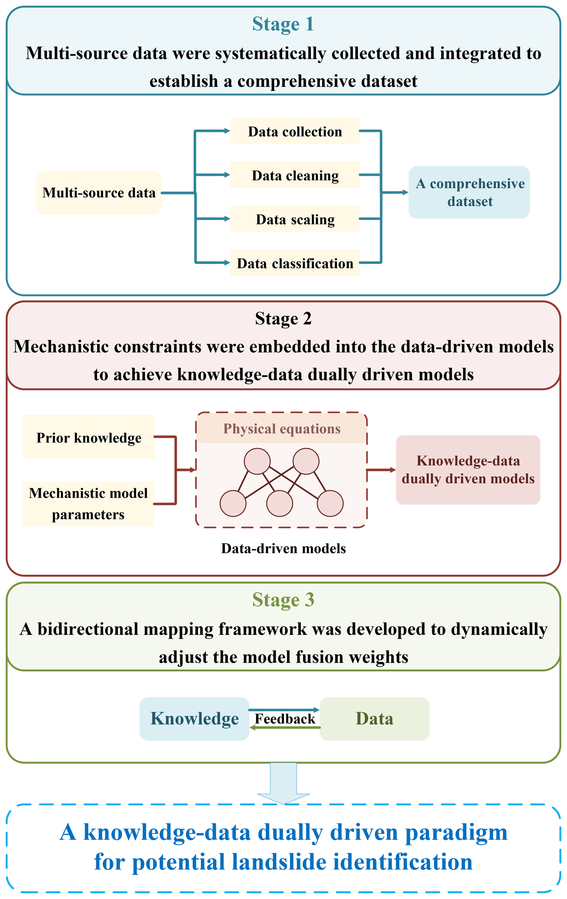
Figure 9Flowchart of knowledge-data dually driven paradigm for potential landslide identification.
Furthermore, since multi-source data may differ in acquisition time and spatial coverage, spatiotemporal alignment is required to ensure interoperability and facilitate synergistic analysis. The collected data should be preprocessed, including cleaning (removal of errors and outliers), standardization (unit homogenization), and classification (based on data type or region). These steps ensure that the data retain inherent physical significance and maintain consistent scales before being input into models, thereby establishing a reliable foundation for subsequent knowledge-data integration.
If the objective extends beyond identifying landslide locations to distinguishing their types and scales, the dataset must encompass information that captures these characteristics. During dataset construction, feature extraction and annotation methods should be chosen to emphasize these distinctions. For instance, combining texture analysis of remote sensing imagery with slope and aspect analysis of terrain data enables the extraction of features correlated with landslide types and magnitudes. Explicit annotations indicating each sample's landslide type and scale are incorporated during labeling.
In the second stage, mechanistic constraints are integrated into the data-driven model to achieve knowledge-data dually driven fusion.
Prior knowledge can be derived from external sources, including domain expertise, historical records, and physical principles, or mechanistic models can be employed to preprocess raw monitoring data. These outputs serve as a foundation for initializing parameters in data-driven models, which is crucial because the choice of initial values substantially affects both training efficiency and final performance (Cui et al., 2024; Liu et al., 2023a; Ma and Mei, 2025).
Beyond initialization, knowledge embedding involves translating landslide physics into model constraints to guide learning and optimization (Dahal and Lombardo, 2025; Liu et al., 2024). At the architectural level, physical equations can be structurally encoded as differentiable network layers, enabling gradient-based optimization. At the loss function level, physical constraints can be directly incorporated into the training objective, ensuring that predictions remain consistent with established principles.
A representative example of this paradigm is the PINN framework (Raissi et al., 2019). PINNs embed governing equations (such as partial differential equations describing slope hydrology or stress-strain processes) into the neural network training objective, thereby constraining the learning process with domain knowledge. This approach not only reduces dependence on large annotated datasets but also enhances interpretability and cross-regional transferability (Karniadakis et al., 2021). Although applications of PINNs in landslide research remain limited (Moeineddin et al., 2023), they provide a promising avenue for bridging purely data-driven approaches with physically grounded mechanisms (Wu et al., 2022).
In the third phase, a bidirectional mapping framework for knowledge-data dually driven is established to facilitate dynamic collaborative optimization.
The model's performance is periodically evaluated using real-time monitoring data, enabling the reverse calibration of knowledge analysis parameters to achieve bidirectional feedback. Through this feedback mechanism, knowledge-data dually driven models undergo mutual verification and iterative refinement.
In practical applications, model validation can be performed using historical or field monitoring data to evaluate predictive accuracy. While optimizing model parameters for region-specific geological conditions, fusion weights are dynamically adjusted based on different stages of landslide evolution. During the initial phase of a landslide, knowledge analysis is more effective in identifying underlying factors and developmental trends, justifying a higher fusion weight for knowledge components. Conversely, during the acceleration or sliding phases, real-time monitoring data becomes crucial, and data-driven models excel at capturing dynamic changes, requiring a higher weight for data-driven components. This dynamic weight adjustment knowledge maximizes the integration of mechanistic and data-driven approaches, enhancing the model's ability to identify landslide risks across different evolutionary stages.
The knowledge-data dually driven paradigm, operating through an iterative “theory-guided data assimilation and data-informed theoretical refinement” mechanism, has advanced potential landslide identification from empirical reliance to scientifically quantifiable methodologies.
Furthermore, the spatial analysis capabilities of Geographic Information System (GIS) were integrated into the practical identification workflow, enabling the study area to be partitioned into distinct landslide risk categories. This risk stratification considers the combined influence of region-specific factors, ensuring scientifically robust and practically viable classifications.
In high-risk areas, detailed investigations can be carried out using spatial remote sensing technologies, including high-resolution optical satellite image change detection and InSAR deformation analysis. Multi-temporal high-resolution optical satellite imagery is analyzed using image change detection algorithms to identify anomalous surface alterations. SAR enables precise measurement of millimeter-scale surface displacements, facilitating early detection of slope deformation precursors. Then, UAVs and airborne LiDAR can then be employed for further identification of high-risk areas. High-resolution imagery can be acquired through UAV-mounted sensors. Image interpretation and analysis facilitate the identification of potential landslide indicators, including irregular slope geometries, soil loosening patterns, and anomalous vegetation growth. LiDAR enables the rapid acquisition of high-precision 3D point cloud data, which accurately captures topographic changes and penetrates vegetation canopies to reveal concealed ground surfaces, aiding in the detection of vegetation-obscured landslide precursors. Ground-based observations are subsequently integrated to validate findings and acquire real-time dynamic information of landslide bodies. A comprehensive assessment, combining expert knowledge with field-derived practical experience, is conducted to finalize the screening and confirmation of potential landslides. Critical parameters including location, scale, hazard level, and potential sliding direction are determined, providing an empirical foundation for subsequent landslide mitigation strategies.
In this review, we summarized the latest advancements in the applications of deep learning for potential landslide identification, as well as the challenges and opportunities for the future. First, we examined seven major heterogeneous data sources available for potential landslide identification. Next, we introduced the five common roles of deep learning models in potential landslide identification. Then, we reviewed the applications of deep learning in the analysis of four typical landslides and discussed the common-used monitoring methods. Finally, we analyzed the current challenges and future research directions.
Several key conclusions are drawn. (1) Single data source often fail to ensure the accuracy of identification, whereas multi-source data fusion can address this issue to some extent. (2) Deep learning models have been widely applied in potential landslide identification, but they still face challenges in terms of interpretability and complexity. Future research should focus on further enhancing the structure and algorithms of deep learning models. (3) Knowledge-data dually driven paradigm for potential landslide identification can improve its accuracy on both theoretical and practical levels.
This review article does not use or generate any original software code.
This review article does not use or generate any original research data.
P.J. and G.M. conceived the review topic and designed the systematic literature framework, defining key research domains for potential landslide identification. P.J. conducted the comprehensive literature search and categorized them into thematic sections. Z.M. provided senior supervision, refining the logical structure. G.M. conducted the final review and editing, enhancing clarity and coherence. All authors approved the submitted version and agree to be accountable for all aspects of the work.
The contact author has declared that none of the authors has any competing interests.
Publisher's note: Copernicus Publications remains neutral with regard to jurisdictional claims made in the text, published maps, institutional affiliations, or any other geographical representation in this paper. The authors bear the ultimate responsibility for providing appropriate place names. Views expressed in the text are those of the authors and do not necessarily reflect the views of the publisher.
We acknowledge the use of GPT (OpenAI) for language refinement during the preparation of this manuscript.
This research has been supported by the China Postdoctoral Science Foundation (grant no. 2024T170859), the Postdoctoral Fellowship Program of CPSF (grant no. GZB20230685) and the National Natural Science Foundation of China (grant no. 42277161).
This paper was edited by Bayes Ahmed and reviewed by three anonymous referees.
Abellán, A., Jaboyedoff, M., Oppikofer, T., and Vilaplana, J. M.: Detection of millimetric deformation using a terrestrial laser scanner: experiment and application to a rockfall event, Nat. Hazards Earth Syst. Sci., 9, 365–372, https://doi.org/10.5194/nhess-9-365-2009, 2009. a
Achu, A. L., Aju, C. D., Di Napoli, M., Prakash, P., Gopinath, G., Shaji, E., and Chandra, V.: Machine-learning based landslide susceptibility modelling with emphasis on uncertainty analysis, Geosci. Front., 14, 101657, https://doi.org/10.1016/j.gsf.2023.101657, 2023. a
Akosah, S., Gratchev, I., Kim, D. H., and Ohn, S. Y.: Application of artificial intelligence and remote sensing for landslide detection and prediction: Systematic review, Remote Sens., 16, 2947, https://doi.org/10.3390/rs16162947, 2024. a
Al-Najjar, H. A. H. and Pradhan, B.: Spatial landslide susceptibility assessment using machine learning techniques assisted by additional data created with generative adversarial networks, Geosci. Front., 12, 625–637, https://doi.org/10.1016/j.gsf.2020.09.002, 2021. a
Al-Najjar, H. A. H., Pradhan, B., Sarkar, R., Beydoun, G., and Alamri, A.: A new integrated approach for landslide data balancing and spatial prediction based on generative adversarial networks (GAN), Remote Sens., 13, 4011, https://doi.org/10.3390/rs13194011, 2021.
Alam, M., Vidyaratne, L., and Iftekharuddin, K. M.: Novel deep generative simultaneous recurrent model for efficient representation learning, Neural Netw., 107, 12–22, https://doi.org/10.1016/j.neunet.2018.04.020, 2018. a
Almalki, R., Khaki, M., Saco, P. M., and Rodriguez, J. F.: Monitoring and mapping vegetation cover changes in arid and semi-arid areas using remote sensing technology: a review, Remote Sens., 14, 5143, https://doi.org/10.3390/rs14205143, 2022. a
Alzubaidi, L., Bai, J., Al-Sabaawi, A., Santamaría, J., Albahri, A. S., Al-Dabbagh, B. S. N., Fadhel, M. A., Manoufali, M., Zhang, J., Al-Timemy, A. H., and Duan, Y.: A survey on deep learning tools dealing with data scarcity: definitions, challenges, solutions, tips, and applications, J. Big Data, 10, 46, https://doi.org/10.1186/s40537-023-00727-2, 2023. a
Amankwah, S. O. Y., Wang, G., Gnyawali, K., Hagan, D. F. T., Sarfo, I., Zhen, D., Nooni, I. K., Ullah, W., and Duan, Z.: Landslide detection from bitemporal satellite imagery using attention-based deep neural networks, Landslides, 19, 2459–2471, https://doi.org/10.1007/s10346-022-01915-6, 2022. a
Arevalo, J., Solorio, T., Montes-y-Gómez, M., and González, F. A.: Gated multimodal units for information fusion, arXiv Prepr., arXiv:1702.01992, https://doi.org/10.48550/arXiv.1702.01992, 2017. a
Arjovsky, M., Chintala, S., and Bottou, L.: Wasserstein GAN, arXiv Prepr. arXiv:1701.07875, https://doi.org/10.48550/arXiv.1701.07875, 2017. a
Arnone, E., Noto, L. V., Lepore, C., and Bras, R. L.: Physically-based and distributed approach to analyze rainfall-triggered landslides at watershed scale, Geomorphology, 133, 121–131, https://doi.org/10.1016/j.geomorph.2011.03.019, 2011. a
Askarinejad, A., Akca, D., and Springman, S. M.: Precursors of instability in a natural slope due to rainfall: A full-scale experiment, Landslides, 15, 1745–1759, https://doi.org/10.1007/s10346-018-0994-0, 2018. a
Aslam, B., Zafar, A., and Khalil, U.: Development of integrated deep learning and machine learning algorithm for the assessment of landslide hazard potential, Soft Comput., 25, 13493–13512, https://doi.org/10.1007/s00500-021-06105-5, 2021. a
Azarafza, M., Azarafza, M., Akgün, H., Atkinson, P. M., and Derakhshani, R.: Deep learning-based landslide susceptibility mapping, Sci. Rep., 11, 24112, https://doi.org/10.1038/s41598-021-03585-1, 2021. a, b
Badakhshan, E., Vaunat, J., and Scarfone, R.: A hysteretic water retention model incorporating the soil deformability and its application to rainfall-induced landslides, Comput. Geotech., 178, 106912, https://doi.org/10.1016/j.compgeo.2024.106912, 2025. a
Bai, D., Lu, G., Zhu, Z., Tang, J., Fang, J., and Wen, A.: Using time series analysis and dual-stage attention-based recurrent neural network to predict landslide displacement, Environ. Earth Sci., 81, 509, https://doi.org/10.1007/s12665-022-10637-w, 2022. a
Bhatt, N., Bhatt, N., Prajapati, P., Sorathiya, V., Alshathri, S., and El-Shafai, W.: A data-centric approach to improve performance of deep learning models, Sci. Rep., 14, 22329, https://doi.org/10.1038/s41598-024-73643-x, 2024.
Bhatta, S., Roy, A., and Shahandashti, M.: Land cover classification using U-Net for calibration of rainfall-induced slope susceptibility maps, in: International Conference on Transportation and Development 2025, 439–448, https://doi.org/10.1061/9780784486191.039, 2025. a
Bhuyan, K., Tanyaş, H., Nava, L., Puliero, S., Meena, S. R., Floris, M., Van Westen, C., and Catani, F.: Generating multi-temporal landslide inventories through a general deep transfer learning strategy using HR EO data, Sci. Rep., 13, 162, https://doi.org/10.1038/s41598-022-27352-y, 2023. a
Biniyaz, A., Azmoon, B., Sun, Y., and Liu, Z.: Long short-term memory based subsurface drainage control for rainfall-induced landslide prevention, Geosci., 12, p. 64, https://doi.org/10.3390/geosciences12020064, 2022. a
Cai, H., Chen, T., Niu, R., and Plaza, A.: Landslide detection using densely connected convolutional networks and environmental conditions, IEEE J. Sel. Top. Appl. Earth Obs. Remote Sens., 14, 5235–5247, https://doi.org/10.1109/JSTARS.2021.3079196, 2021. a, b
Cai, W., Lan, F., Huang, X., Hao, J., Xia, W., Tang, R., Feng, P., and Li, H.: Generative probabilistic prediction of precipitation-induced landslide deformation with variational autoencoder and gated recurrent unit, Front. Earth Sci., 12, 1394129, https://doi.org/10.3389/feart.2024.1394129, 2024. a
Casagli, N., Intrieri, E., Tofani, V., Gigli, G., and Raspini, F.: Landslide detection, monitoring and prediction with remote-sensing techniques, Nat. Rev. Earth Environ., 4, 51–64, https://doi.org/10.1038/s43017-022-00373-x, 2023. a
Cascini, L., Scoppettuolo, M. R., and Babilio, E.: Forecasting the landslide evolution: from theory to practice, Landslides, 19, 2839–2851, https://doi.org/10.1007/s10346-022-01934-3, 2022. a
Chandra, N., Sawant, S., and Vaidya, H.: An efficient U-Net model for improved landslide detection from satellite images, PFG J. Photogramm. Remote Sens. Geoinf. Sci., 91, 13–28, https://doi.org/10.1007/s41064-023-00232-4, 2023. a
Chang, F., Dong, S., Yin, H., Ye, X., Wu, Z., Zhang, W., and Zhu, H.: 3D displacement time series prediction of a north-facing reservoir landslide powered by InSAR and machine learning, J. Rock Mech. Geotech. Eng., https://doi.org/10.1016/j.jrmge.2024.10.033, 2025. a
Chen, C. and Fan, L.: CNN-LSTM-attention deep learning model for mapping landslide susceptibility in Kerala, India, ISPRS Ann. Photogramm. Remote Sens. Spatial Inf. Sci., 10, 25–30, https://doi.org/10.5194/isprs-annals-X-3-W1-2022-25-2022, 2022.
Chen, H., Zeng, Z., and Tang, H.: Landslide deformation prediction based on recurrent neural network, Neural Process. Lett., 41, 169–178, https://doi.org/10.1007/s11063-013-9318-5, 2015. a
Chen, L. C., Papandreou, G., Kokkinos, I., Murphy, K., and Yuille, A. L.: Deeplab: Semantic image segmentation with deep convolutional nets, atrous convolution, and fully connected CRFs, IEEE Trans. Pattern Anal. Mach. Intell., 40, 834–848, https://doi.org/10.1109/TPAMI.2017.2699184, 2017. a
Chen, X., Yao, X., Zhou, Z., Liu, Y., Yao, C., and Ren, K.: DRs-UNet: a deep semantic segmentation network for the recognition of active landslides from InSAR imagery in the three rivers region of the Qinghai–Tibet Plateau, Remote Sens., 14, 1848, https://doi.org/10.3390/rs14081848, 2022. a
Chen, H., He, Y., Zhang, L., Yang, W., Liu, Y., Gao, B., Zhang, Q., and Lu, J.: A multi-input channel U-Net landslide detection method fusing SAR multisource remote sensing data, IEEE J. Sel. Top. Appl. Earth Obs. Remote Sens., 17, 1215–1232, https://doi.org/10.1109/JSTARS.2023.3339294, 2023a. a
Chen, L., Ge, X., Yang, L., Li, W., and Peng, L.: An improved multi-source data-driven landslide prediction method based on spatio-temporal knowledge graph, Remote Sens., 15, 2126, https://doi.org/10.3390/rs15082126, 2023b. a
Chen, J., Zeng, X., Zhu, J., Guo, Y., Hong, L., Deng, M., and Chen, K.: The diverse mountainous landslide dataset (DMLD): a high-resolution remote sensing landslide dataset in diverse mountainous regions, Remote Sens., 16, 1886, https://doi.org/10.3390/rs16111886, 2024a. a
Chen, J.-X., Liu, H.-D., Guo, Z.-F., Liu, J.-J., Feng, L.-Y., and Liu, S.: Research on failure mechanism of landslide with retaining-wall-like locked segment and instability prediction by inverse velocity method, Sci. Rep., 14, 21359, https://doi.org/10.1038/s41598-024-72154-z, 2024b. a
Chen, M., Qian, Z., Boers, N., Creutzig, F., Camps-Valls, G., Hubacek, K., Claramunt, C., Wilson, J. P., Nativi, S., Jakeman, A. J., and Müller, R. D.: Collaboration between artificial intelligence and Earth science communities for mutual benefit, Nat. Geosci., 17, 949–952, https://doi.org/10.1038/s41561-024-01550-x, 2024c. a
Cheng, G. and Han, J.: A survey on object detection in optical remote sensing images, ISPRS J. Photogramm. Remote Sens., 117, 11–28, https://doi.org/10.1016/j.isprsjprs.2016.03.014, 2016. a
Cho, K., Van Merriënboer, B., Gulcehre, C., Bahdanau, D., Bougares, F., Schwenk, H., and Bengio, Y.: Learning phrase representations using RNN encoder-decoder for statistical machine translation, arXiv Prep. arXiv:1406.1078, https://doi.org/10.48550/arXiv.1406.1078, 2014. a
Choi, J., Kim, S., Jeong, Y., Gwon, Y., and Yoon, S.: ILVR: Conditioning method for denoising diffusion probabilistic models, arXiv Prep. arXiv:2108.02938, https://doi.org/10.48550/arXiv.2108.02938, 2021.
Chowdhuri, I., Pal, S. C., Saha, A., Chakrabortty, R., and Roy, P.: Mapping of earthquake hotspot and coldspot zones for identifying potential landslide hotspot areas in the Himalayan region, Bull. Eng. Geol. Environ., 81, 257, https://doi.org/10.1007/s10064-022-02761-5, 2022. a
Chung, J., Gulcehre, C., Cho, K., and Bengio, Y.: Empirical evaluation of gated recurrent neural networks on sequence modeling, arXiv Prep. arXiv:1412.3555, https://doi.org/10.48550/arXiv.1412.3555, 2014. a
Coluzzi, R., Perrone, A., Samela, C., Imbrenda, V., Manfreda, S., Pace, L., and Lanfredi, M.: Rapid landslide detection from free optical satellite imagery using a robust change detection technique, Sci. Rep., 15, 4697, https://doi.org/10.1038/s41598-025-89542-8, 2025. a
Croitoru, F.-A., Hondru, V., Ionescu, R. T., and Shah, M.: Diffusion models in vision: A survey, IEEE Trans. Pattern Anal. Mach. Intell., 45, 10850–10869, https://doi.org/10.1109/TPAMI.2023.3261988, 2023. a
Cui, H., Tong, B., Wang, T., Dou, J., and Ji, J.: A hybrid data-driven approach for rainfall-induced landslide susceptibility mapping: physically-based probabilistic model with convolutional neural network, J. Rock Mech. Geotech. Eng., https://doi.org/10.1016/j.jrmge.2024.08.005, 2024. a
D'Amario, V., Srivastava, S., Sasaki, T., and Boix, X.: The data efficiency of deep learning is degraded by unnecessary input dimensions, Front. Comput. Neurosci., 16, 760085, https://doi.org/10.3389/fncom.2022.760085, 2022. a
Dahal, A. and Lombardo, L.: Towards physics-informed neural networks for landslide prediction, Eng. Geol., 344, 107852, https://doi.org/10.1016/j.enggeo.2024.107852, 2025. a
Dahal, A., Tanyas, H., and Lombardo, L.: Full seismic waveform analysis combined with transformer neural networks improves coseismic landslide prediction, Commun. Earth Environ., 5, 75, https://doi.org/10.1038/s43247-024-01243-8, 2024. a
Dai, K., Feng, Y., Zhuo, G., Tie, Y., Deng, J., Balz, T., and Li, Z.: Applicability analysis of potential landslide identification by InSAR in Alpine-Canyon terrain – Case study on Yalong River, IEEE J. Sel. Top. Appl. Earth Obs. Remote Sens., 15, 2110–2118, https://doi.org/10.1109/JSTARS.2022.3228948, 2022. a
Dai, K., Li, Z., Xu, Q., Tomas, R., Li, T., Jiang, L., Zhang, J., Yin, T., and Wang, H.: Identification and evaluation of the high mountain upper slope potential landslide based on multi-source remote sensing: the Aniangzhai landslide case study, Landslides, 20, 1405–1417, https://doi.org/10.1007/s10346-023-02044-4, 2023. a
Das, P., Posch, A., Barber, N., Hicks, M., Duffy, K., Vandal, T., Singh, D., van Werkhoven, K., and Ganguly, A. R.: Hybrid physics-AI outperforms numerical weather prediction for extreme precipitation nowcasting, npj Clim. Atmos. Sci., 7, 2024, https://doi.org/10.1038/s41612-024-00834-8. a
Deijns, A. A. J., Bevington, A. R., van Zadelhoff, F., de Jong, S. M., Geertsema, M., and McDougall, S.: Semi-automated detection of landslide timing using harmonic modelling of satellite imagery, Buckinghorse River, Canada, Int. J. Appl. Earth Obs. Geoinf., 84, 101943, https://doi.org/10.1016/j.jag.2019.101943, 2020. a
Ding, X., Zhang, X., Han, J., and Ding, G.: Scaling up your kernels to 31x31: Revisiting large kernel design in CNNs, in: Proc. IEEE/CVF Conf. Comput. Vis. Pattern Recognit., 11963–11975 pp., https://doi.org/10.48550/arXiv.2203.06717, 2022. a
Dong, Z., An, S., Zhang, J., Yu, J., Li, J., and Xu, D.: L-unet: A landslide extraction model using multi-scale feature fusion and attention mechanism, Remote Sens., 14, 2552, https://doi.org/10.3390/rs14112552, 2022. a
Dou, J., Yunus, A. P., Bui, D. T., Sahana, M., Chen, C.-W., Zhu, Z., Wang, W., and Pham, B. T.: Evaluating GIS-based multiple statistical models and data mining for earthquake and rainfall-induced landslide susceptibility using the LiDAR DEM, Remote Sens., 11, 638, https://doi.org/10.3390/rs11060638, 2019. a
Dubovik, O., Schuster, G. L., Xu, F., Hu, Y., Bösch, H., Landgraf, J., and Li, Z.: Grand challenges in satellite remote sensing, Front. Remote Sens., 2, 619818, https://doi.org/10.3389/frsen.2021.619818, 2021. a
Dun, J., Feng, W., Yi, X., Zhang, G., and Wu, M.: Detection and mapping of active landslides before impoundment in the Baihetan Reservoir Area (China) based on the time-series InSAR method, Remote Sens., 13, 3213, https://doi.org/10.3390/rs13163213, 2021. a
Ebrahimi, M. S. and Abadi, H. K.: Study of residual networks for image recognition, in: Intell. Comput., Proc. 2021 Comput. Conf., Vol. 2, 754–763 pp., Springer Int. Publ., https://doi.org/10.1007/978-3-030-80126-7_53, 2021. a
Ehsan, M., Anees, M. T., Bakar, A. F. B. A., and Ahmed, A.: A review of geological and triggering factors influencing landslide susceptibility: Artificial intelligence-based trends in mapping and prediction, Int. J. Environ. Sci. Technol., 1–36, https://doi.org/10.1007/s13762-025-06741-6, 2025. a
Elman, J. L.: Finding Structure in Time, Cogn. Sci., 14, 179–211, https://doi.org/10.1207/s15516709cog1402_1, 1990. a
Esser, P., Rombach, R., and Ommer, B.: Taming transformers for high-resolution image synthesis, in: Proc. IEEE/CVF Conf. Comput. Vis. Pattern Recognit., 12873–12883 pp., 2021. a
Fahlstrom, P. G., Gleason, T. J., and Sadraey, M. H.: Introduction to UAV Systems, John Wiley & Sons, https://www.wiley.com/en-us/9781119802617 (last access: 18 January 2026), 2022.
Fan, X., Scaringi, G., Korup, O., West, A. J., van Westen, C. J., Tanyas, H., Hovius, N., Hales, T. C., Jibson, R. W., Allstadt, K. E., and Zhang, L.: Earthquake-induced chains of geologic hazards: Patterns, mechanisms, and impacts, Rev. Geophys., 57, 421–503, https://doi.org/10.1029/2018RG000626, 2019. a
Fan, B., Li, Y., Zhang, R., and Fu, Q.: Review on the technological development and application of UAV systems, Chin. J. Electron., 29, 199–207, https://doi.org/10.1049/cje.2019.12.006, 2020. a
Fang, B., Chen, G., Pan, L., Kou, R., and Wang, L.: GAN-based Siamese framework for landslide inventory mapping using bi-temporal optical remote sensing images, IEEE Geosci. Remote Sens. Lett., 18, 391–395, https://doi.org/10.1109/LGRS.2020.2979693, 2020. a
Fang, Z., Wang, Y., Peng, L., and Hong, H.: A comparative study of heterogeneous ensemble-learning techniques for landslide susceptibility mapping, Int. J. Geogr. Inf. Sci., 35, 321–347, https://doi.org/10.1080/13658816.2020.1808897, 2021. a
Fang, C., Fan, X., Zhong, H., Lombardo, L., Tanyas, H., and Wang, X.: A novel historical landslide detection approach based on LiDAR and lightweight attention U-Net, Remote Sens., 14, 4357, https://doi.org/10.3390/rs14174357, 2022. a
Fang, C., Fan, X., Wang, X., Nava, L., Zhong, H., Dong, X., Qi, J., and Catani, F.: A globally distributed dataset of coseismic landslide mapping via multi-source high-resolution remote sensing images, Earth Syst. Sci. Data, 16, 4817–4842, https://doi.org/10.5194/essd-16-4817-2024, 2024. a
Farmakis, I., DiFrancesco, P. M., Hutchinson, D. J., and Vlachopoulos, N.: Rockfall detection using LiDAR and deep learning, Eng. Geol., 309, 106836, https://doi.org/10.1016/j.enggeo.2022.106836, 2022. a
Feng, H., Miao, Z., and Hu, Q.: Study on the uncertainty of machine learning model for earthquake-induced landslide susceptibility assessment, Remote Sens., 14, 2968, https://doi.org/10.3390/rs14132968, 2022. a
Feng, X., Du, J., Wu, M., Chai, B., Miao, F., and Wang, Y.: Potential of synthetic images in landslide segmentation in data-poor scenario: a framework combining GAN and transformer models, Landslides, 21, 2211–2226, https://doi.org/10.1007/s10346-024-02274-0, 2024. a
Fidan, S., Tanyas, H., Akbas, A., Lombardo, L., Petley, D. N., and Gorum, T.: Understanding fatal landslides at global scales: A summary of topographic, climatic, and anthropogenic perspectives, Nat. Hazards, 120, 6437–6455, https://doi.org/10.1007/s11069-024-06487-3, 2024. a
Fiorucci, F., Giordan, D., Santangelo, M., Dutto, F., Rossi, M., and Guzzetti, F.: Criteria for the optimal selection of remote sensing optical images to map event landslides, Nat. Hazards Earth Syst. Sci., 18, 405–417, https://doi.org/10.5194/nhess-18-405-2018, 2018. a
Franceschetti, G. and Lanari, R.: Synthetic Aperture Radar Processing, CRC Press, https://doi.org/10.1201/9780203737484, 2018. a
Fu, S., de Jong, S. M., Hou, X., de Vries, J., Deijns, A., and de Haas, T.: A landslide dating framework using a combination of Sentinel-1 SAR and-2 optical imagery, Eng. Geol., 329, 107388, https://doi.org/10.1016/j.enggeo.2023.107388, 2024. a
Gaidzik, K. and Ramírez-Herrera, M. T.: The importance of input data on landslide susceptibility mapping, Sci. Rep., 11, 19334, https://doi.org/10.1038/s41598-021-98830-y, 2021. a
Gao, H., Gao, Y., Li, B., Yin, Y., Yang, C., Wan, J., and Zhang, T.: The dynamic simulation and potential hazards analysis of the Yigong landslide in Tibet, China, Remote Sens., 15, 1322, https://doi.org/10.3390/rs15051322, 2023. a
Gao, B., He, Y., Chen, X., Chen, H., Yang, W., and Zhang, L.: A deep neural network framework for landslide susceptibility mapping by considering time-series rainfall, IEEE J. Sel. Top. Appl. Earth Obs. Remote Sens., https://doi.org/10.1109/JSTARS.2024.3370218, 2024. a
Ge, X., Yang, Y., Chen, J., Li, W., Huang, Z., Zhang, W., and Peng, L.: Disaster prediction knowledge graph based on multi-source spatio-temporal information, Remote Sens., 14, 1214, https://doi.org/10.3390/rs14051214, 2022. a
Ge, Q., Li, J., Wang, X., Deng, Y., Zhang, K., and Sun, H.: LiteTransNet: An interpretable approach for landslide displacement prediction using transformer model with attention mechanism, Eng. Geol., 331, 107446, https://doi.org/10.1016/j.enggeo.2024.107446, 2024. a
Geiger, A., Liu, D., Alnegheimish, S., Cuesta-Infante, A., and Veeramachaneni, K.: TadGAN: Time series anomaly detection using generative adversarial networks, in: 2020 IEEE Int. Conf. Big Data (Big Data), 33–43, IEEE, https://doi.org/10.1109/BigData50022.2020.9378139, 2020. a
Ghorbanzadeh, O., Shahabi, H., Crivellari, A., Homayouni, S., Blaschke, T., and Ghamisi, P.: Landslide detection using deep learning and object-based image analysis, Landslides, 19, 929–939, https://doi.org/10.1007/s10346-021-01843-x, 2022a. a
Ghorbanzadeh, O., Xu, Y., Zhao, H., Wang, J., Zhong, Y., Zhao, D., Zang, Q., Wang, S., Zhang, F., Shi, Y., and Zhu, X. X.: The outcome of the 2022 landslide4sense competition: advanced landslide detection from multisource satellite imagery, IEEE J. Sel. Top. Appl. Earth Obs. Remote Sens., 15, 9927–9942, https://doi.org/10.1109/JSTARS.2022.3220845, 2022b. a
Gidon, J. S., Borah, J., Sahoo, S., Majumdar, S., and Fujita, M.: Bidirectional LSTM model for accurate and real-time landslide detection: A case study in Mawiongrim, Meghalaya, India, IEEE Internet Things J., 11, 3792–3800, https://doi.org/10.1109/JIOT.2023.3326203, 2023. a
Goodfellow, I. J., Pouget-Abadie, J., Mirza, M., Xu, B., Warde-Farley, D., Ozair, S., Courville, A., and Bengio, Y.: Generative adversarial nets, Adv. Neural Inf. Process. Syst., 27, https://proceedings.neurips.cc/paper/2014/hash/f033ed80deb0234979a61f95710dbe25-Abstract.html (last access: 18 January 2026), 2014. a
Graves, A.: Long short-term memory, in: Supervised Sequence Labelling with Recurrent Neural Networks, 37–45, https://doi.org/10.1007/978-3-642-24797-2_4, 2012. a
Gui, J., Sun, Z., Wen, Y., Tao, D., and Ye, J.: A review on generative adversarial networks: Algorithms, theory, and applications, IEEE Trans. Knowl. Data Eng., 35, 3313–3332, https://doi.org/10.1109/TKDE.2021.3130191, 2021. a
Guo, Y., Liu, Y., Georgiou, T., and Lew, M. S.: A review of semantic segmentation using deep neural networks, Int. J. Multimed. Inf. Retr., 7, 87–93, https://doi.org/10.1007/s13735-017-0141-z, 2018. a
Guo, W., Ye, J., Liu, C., Lv, Y., Zeng, Q., and Huang, X.: An approach for predicting landslide susceptibility and evaluating predisposing factors, Int. J. Appl. Earth Obs. Geoinf., 135, 104217, https://doi.org/10.1016/j.jag.2024.104217, 2024. a
Guo, D., Yang, X., Peng, P., Zhu, L., and He, H.: The intelligent fault identification method based on multi-source information fusion and deep learning, Sci. Rep., 15, 6643, https://doi.org/10.1038/s41598-025-90823-5, 2025. a
Gupta, S. K. and Shukla, D. P.: Handling data imbalance in machine learning based landslide susceptibility mapping: a case study of Mandakini River Basin, North-Western Himalayas, Landslides, 20, 933–949, https://doi.org/10.1007/s10346-022-01998-1, 2023. a
Gupta, A., Paul, S., Bhattacharya, A., and Jain, P.: A framework for realistic paired dataset generation for deep learning based restoration of satellite images, in: Proc. IEEE Int. Geosci. Remote Sens. Symp. (IGARSS), 6997–7002, https://doi.org/10.1109/IGARSS53475.2024.10640440, 2024. a
Guzzetti, F., Gariano, S. L., Peruccacci, S., Brunetti, M. T., Marchesini, I., Rossi, M., and Melillo, M.: Geographical landslide early warning systems, Earth-Sci. Rev., 200, 102973, https://doi.org/10.1016/j.earscirev.2019.102973, 2020. a
Hamaguchi, R., Fujita, A., Nemoto, K., Imaizumi, T., and Hikosaka, S.: Effective use of dilated convolutions for segmenting small object instances in remote sensing imagery, in: 2018 IEEE Winter Conf. Appl. Comput. Vis. (WACV), 1442–1450 pp., https://doi.org/10.1109/WACV.2018.00162, 2018. a
Han, J., Yang, H., Liu, Y., Lu, Z., Zeng, K., and Jiao, R.: A deep learning application for deformation prediction from ground-based InSAR, Remote Sens., 14, p. 5067, https://doi.org/10.3390/rs14205067, 2022. a, b
Han, L., Duan, P., Liu, J., and Li, J.: Research on landslide trace recognition by fusing UAV-based lidar dem multi-feature information, Remote Sens., 15, 4755, https://doi.org/10.3390/rs15194755, 2023. a
Han, N., Miao, W., Li, M., Mohamad Ismail, M. A., Hu, Q., Duan, L., and Tang, J.: Integrating multi-source monitoring data and deep convolutional autoencoder technology for slope failure pattern recognition, Front. Earth Sci., 13, 1531857, https://doi.org/10.3389/feart.2025.1531857, 2025. a
Hao, Y., Liu, C., Zhang, W., Liu, X., and Liu, G.: Landslide risk evaluation: rainfall and blast-induced potential soil landslides in an expressway area underneath a railway tunnel, Guangzhou, China, Bull. Eng. Geol. Environ., 82, 420, https://doi.org/10.1007/s10064-023-03449-0, 2023. a
Hasanah, S. A., Pravitasari, A. A., Abdullah, A. S., Yulita, I. N., and Asnawi, M. H.: A deep learning review of ResNet architecture for lung disease identification in CXR image, Appl. Sci., 13, 13111, https://doi.org/10.3390/app132413111, 2023. a
He, K., Zhang, X., Ren, S., and Sun, J.: Deep residual learning for image recognition, in: Proc. IEEE Conf. Comput. Vis. Pattern Recognit., 770–778 pp., https://doi.org/10.1109/CVPR.2016.90, 2016. a
Hinton, G. E. and Salakhutdinov, R. R.: Reducing the dimensionality of data with neural networks, Science, 313, 504–507, https://doi.org/10.1126/science.1127647, 2006. a
Ho, J., Jain, A., and Abbeel, P.: Denoising diffusion probabilistic models, Adv. Neural Inf. Process. Syst., 33, 6840–6851, 2020. a
Ho, J., Saharia, C., Chan, W., Fleet, D. J., Norouzi, M., and Salimans, T.: Cascaded diffusion models for high fidelity image generation, J. Mach. Learn. Res., 23, 1–33, 2022.
Hochreiter, S. and Schmidhuber, J.: Long Short-Term Memory, Neural Comput., 9, 1735–1780, https://doi.org/10.1162/neco.1997.9.8.1735, 1997.
Hu, F., Gao, X. M., Li, G. Y., and Li, M.: DEM extraction from worldview-3 stereo-images and accuracy evaluation, Int. Arch. Photogramm. Remote Sens. Spatial Inf. Sci., 41, 327–332, https://doi.org/10.5194/isprs-archives-XLI-B1-327-2016, 2016. a
Hu, W., Sun, G., Zeng, X., Tong, B., Wang, Z., Wu, X., and Song, P.: Hierarchical cross attention achieves pixel precise landslide segmentation in submeter optical imagery, Sci. Rep., 15, p. 21933, https://doi.org/10.1038/s41598-025-08695-8, 2025a. a
Hu, X., Sun, Z., Wang, Z., Huang, X., Zhou, M., He, S., and Xu, W.: InSAR-based deep learning prediction model for multi-type landslides displacement and failure time in Zigui, Three Gorges Area, China, Landslides, 1–15, https://doi.org/10.1007/s10346-025-02613-9, 2025b. a
Huang, R. and Chen, T.: Landslide recognition from multi-feature remote sensing data based on improved transformers, Remote Sens., 15, 3340, https://doi.org/10.3390/rs15133340, 2023. a
Huang, G., Liu, Z., van der Maaten, L., and Weinberger, K. Q.: Densely connected convolutional networks, in: Proc. IEEE Conf. Comput. Vis. Pattern Recognit., 4700–4708 pp., 2017. a
Huang, R., Jiang, L., Shen, X., Dong, Z., Zhou, Q., Yang, B., and Wang, H.: An efficient method of monitoring slow-moving landslides with long-range terrestrial laser scanning: a case study of the Dashu landslide in the Three Gorges Reservoir Region, China, Landslides, 16, 839–855, https://doi.org/10.1007/s10346-018-1118-6, 2019. a
Huang, F., Ye, Z., Zhou, X., Huang, J., and Zhou, C.: Landslide susceptibility prediction using an incremental learning Bayesian Network model considering the continuously updated landslide inventories, Bull. Eng. Geol. Environ., 81, 250, https://doi.org/10.1007/s10064-022-02748-2, 2022a. a
Huang, H., Xue, R., Zhao, B., Yi, W., Deng, Y., Dong, Z., Liu, Q., Yi, Q., and Zhang, G.: The bedding rock landslide identification in the head area of the Three Gorges Reservoir combined with disaster pregnant mechanism and comprehensive remote sensing method, Acta Geod. Cartogr. Sin., 51, 2056, https://doi.org/10.11947/j.AGCS.2022.20220306, 2022b. a
Huang, L., Luo, R., Liu, X., and Hao, X.: Spectral imaging with deep learning, Light Sci. Appl., 11, 61, https://doi.org/10.1038/s41377-022-00743-6, 2022c. a
Huang, H., Lim, T. C., Wu, J., Ding, W., and Pang, J.: Multitarget prediction and optimization of pure electric vehicle tire/road airborne noise sound quality based on a knowledge-and data-driven method, Mech. Syst. Signal Process., 197, 110361, https://doi.org/10.1016/j.ymssp.2023.110361, 2023a. a
Huang, Y., Zhang, J., He, H., Jia, Y., Chen, R., Ge, Y., Ming, Z., Zhang, L., and Li, H.: MAST: An earthquake-triggered landslides extraction method combining morphological analysis edge recognition with swin-transformer deep learning model, IEEE J. Sel. Top. Appl. Earth Obs. Remote Sens., 17, 2586–2595, https://doi.org/10.1109/JSTARS.2023.3342989, 2023b. a
Huang, J., Song, W., Liu, T., Cui, X., Yan, J., and Wang, X.: Submarine landslide identification based on improved DeepLabv3 with spatial and channel attention, Remote Sens., 16, 4205, https://doi.org/10.3390/rs16224205, 2024. a
Huangfu, W., Qiu, H., Cui, P., Yang, D., Liu, Y., Ullah, M., and Kamp, U.: Automated extraction of mining-induced ground fissures using deep learning and object-based image classification, Earth Surf. Process. Landforms, 49, 2189–2204, https://doi.org/10.1002/esp.5824, 2024. a
Hussain, M., Bird, J. J., and Faria, D. R.: A study on CNN transfer learning for image classification, in: Adv. Comput. Intell. Syst.: Contrib. Presented at 18th UK Workshop Comput. Intell., 191–202 pp., https://doi.org/10.1007/978-3-319-97982-3_16, 2019. a
Islam, Z., Abdel-Aty, M., Cai, Q., and Yuan, J.: Crash data augmentation using variational autoencoder, Accid. Anal. Prev., 151, 105950, https://doi.org/10.1016/j.aap.2020.105950, 2021. a
Isola, P., Zhu, J. Y., Zhou, T., and Efros, A. A.: Image-to-Image Translation with Conditional Adversarial Networks, in: Proc. IEEE Conf. Comput. Vis. Pattern Recognit., 1125–1134 pp., https://doi.org/10.1109/CVPR.2017.632, 2017. a
Indian Space Research Organisation: NISAR – NASA–ISRO Synthetic Aperture Radar Mission, https://www.isro.gov.in/Mission_GSLVF16_NISAR_Home.html (last access: 26 October 2025), 2025. a
Jaboyedoff, M., Oppikofer, T., Abellán, A., Derron, M.-H., Loye, A., Metzger, R., and Pedrazzini, A.: Use of LIDAR in landslide investigations: a review, Nat. Hazards, 61, 5–28, https://doi.org/10.1007/s11069-010-9634-2, 2012. a
Janiesch, C., Zschech, P., and Heinrich, K.: Machine learning and deep learning, Electron. Mark., 31, 685–695, https://doi.org/10.1007/s12525-021-00475-2, 2021. a
Ji, S., Yu, D., Shen, C., Li, W., and Xu, Q.: Landslide detection from an open satellite imagery and digital elevation model dataset using attention boosted convolutional neural networks, Landslides, 17, 1337–1352, https://doi.org/10.1007/s10346-020-01353-2, 2020. a
Jiang, T., Li, Y., Xie, W., and Du, Q.: Discriminative reconstruction constrained generative adversarial network for hyperspectral anomaly detection, IEEE Trans. Geosci. Remote Sens., 58, 4666–4679, https://doi.org/10.1109/TGRS.2020.2965961, 2020. a
Jiang, W., Xi, J., Li, Z., Zang, M., Chen, B., Zhang, C., and Zhu, W.: Deep learning for landslide detection and segmentation in high-resolution optical images along the Sichuan-Tibet transportation corridor, Remote Sens., 14, 5490, https://doi.org/10.3390/rs14215490, 2022a. a
Jiang, Y., Luo, H., Xu, Q., Lu, Z., Liao, L., Li, H., and Hao, L.: A graph convolutional incorporating GRU network for landslide displacement forecasting based on spatiotemporal analysis of GNSS observations, Remote Sens., 14, 1016, https://doi.org/10.3390/rs14041016, 2022b. a
Jiang, X.-D., Hou, T.-S., Guo, S.-L., and Chen, Y.: Influence of cracks on loess collapse under heavy rainfall, Catena, 223, 106959, https://doi.org/10.1016/j.catena.2023.106959, 2023. a
Jiang, Y., Wang, W., Zou, L., Cao, Y., and Xie, W.-C.: Investigating landslide data balancing for susceptibility mapping using generative and machine learning models, Landslides, 1–16, https://doi.org/10.1007/s10346-024-02352-3, 2024. a
Jibson, R. W.: Regression models for estimating coseismic landslide displacement, Eng. Geol., 91, 209–218, https://doi.org/10.1016/j.enggeo.2007.01.013, 2007. a
Jin, Y., Li, X., Zhu, S., Tong, B., Chen, F., Cui, R., and Huang, J.: Accurate landslide identification by multisource data fusion analysis with improved feature extraction backbone network, Geomatics, Nat. Hazards Risk, 13, 2313–2332, https://doi.org/10.1080/19475705.2022.2116357, 2022. a
Jing, R., Duan, F., Lu, F., Zhang, M., and Zhao, W.: Denoising diffusion probabilistic feature-based network for cloud removal in Sentinel-2 imagery, Remote Sens., 15, 2217, https://doi.org/10.3390/rs15092217, 2023.
Jones, N., Manconi, A., and Strom, A.: Active landslides in the Rogun Catchment, Tajikistan, and their river damming hazard potential, Landslides, 18, 3599–3613, https://doi.org/10.1007/s10346-021-01706-5, 2021. a
Kačan, M., Turčinović, F., Bojanjac, D., and Bosiljevac, M.: Deep learning approach for object classification on raw and reconstructed GBSAR data, Remote Sens., 14, 5673, https://doi.org/10.3390/rs14225673, 2022.
Kang, X., Li, Y., Zhang, Y., Ma, N., and Wen, L.: Anomaly detection in concrete dam using memory-augmented autoencoder and generative adversarial network (MemAE-GAN), Autom. Constr., 168, 105794, https://doi.org/10.1016/j.autcon.2024.105794, 2024. a
Kargel, J. S., Leonard, G. J., Shugar, D. H., Haritashya, U. K., Bevington, A., Fielding, E. J., Fujita, K., Geertsema, M., Miles, E. S., Steiner, J., and Anderson, E.: Geomorphic and geologic controls of geohazards induced by Nepal's 2015 Gorkha earthquake, Science, 351, aac8353, https://doi.org/10.1126/science.aac8353, 2016. a
Karniadakis, G. E., Kevrekidis, I. G., Lu, L., Perdikaris, P., Wang, S., and Yang, L.: Physics-informed machine learning, Nat. Rev. Phys., 3, 422–440, https://doi.org/10.1038/s42254-021-00314-5, 2021. a
Karras, T., Aittala, M., Hellsten, J., Laine, S., Lehtinen, J., and Aila, T.: Training generative adversarial networks with limited data, Adv. Neural Inf. Process. Syst., 33, 12104–12114, 2020. a
Kattenborn, T., Leitloff, J., Schiefer, F., and Hinz, S.: Review on Convolutional Neural Networks (CNN) in vegetation remote sensing, ISPRS J. Photogramm. Remote Sens., 173, 24–49, https://doi.org/10.1016/j.isprsjprs.2020.12.010, 2021. a
Kavzoglu, T., Teke, A., and Yilmaz, E. O.: Shared blocks-based ensemble deep learning for shallow landslide susceptibility mapping, Remote Sens., 13, 4776, https://doi.org/10.3390/rs13234776, 2021. a
Kilgore, A. and Restrepo, C.: Integrating hyperspectral imaging, plant functional diversity, and soil-lithology to uncover mountainscape disturbance dynamics induced by landsliding, Remote Sens., 17, 1806, https://doi.org/10.3390/rs17111806, 2025. a
Kim, H.-J. and Lee, D.: Image denoising with conditional generative adversarial networks (CGAN) in low dose chest images, Nucl. Instrum. Methods Phys. Res. A, 954, 161914, https://doi.org/10.1016/j.nima.2019.02.041, 2020. a
Kingma, D. P. and Welling, M.: Auto-encoding variational bayes, arXiv Prep. arXiv:1312.6114, https://doi.org/10.48550/arXiv.1312.6114, 2013. a, b
Kingma, D. P., Mohamed, S., Rezende, D. J., and Welling, M.: Semi-supervised learning with deep generative models, Adv. Neural Inf. Process. Syst., 27, https://doi.org/10.48550/arXiv.1406.5298, 2014. a
Kipf, T. N. and Welling, M.: Semi-Supervised Classification with Graph Convolutional Networks, arXiv preprint arXiv:1609.02907, https://doi.org/10.48550/arXiv.1609.02907, 2016. a
Kong, L., Feng, W., Yi, X., Xue, Z., and Bai, L.: Enhanced landslide susceptibility mapping in data-scarce regions via unsupervised few-shot learning, Gondwana Res., 138, 31–46, https://doi.org/10.1016/j.gr.2024.10.011, 2025. a
Koukiou, G.: SAR Features and Techniques for Urban Planning – A Review, Remote Sens., 16, 1923, https://doi.org/10.3390/rs16111923, 2024. a
Kuang, P., Li, R., Huang, Y., Wu, J., Luo, X., and Zhou, F.: Landslide displacement prediction via attentive graph neural network, Remote Sens., 14, 1919, https://doi.org/10.3390/rs14081919, 2022. a, b
Kumar, A. and Vepa, J.: Gated mechanism for attention based multi modal sentiment analysis, in: Proc. IEEE Int. Conf. Acoust. Speech Signal Process. (ICASSP), 4477–4481 pp., https://doi.org/10.1109/ICASSP40776.2020.9053012, 2020. a
Kumar, P., Priyanka, P., Uday, K. V., and Dutt, V.: Predictive modelling of Himalayan soil movement: addressing imbalance with synthetic variational autoencoder data in Kamand Valley, in: International Congress on Information and Communication Technology, 137–147 pp., Springer Nature Singapore, https://doi.org/10.1007/978-981-97-3299-9_11, 2024. a
Lakhote, A., Chan, Y. C., Lu, C. Y., Kumar, G., and Sun, C. W.: Monitoring slow-moving deep-seated landslide using PSI technique: A case study of a potential sliding slope from southern Taiwan, Landslides, 22, 1677–1692, https://doi.org/10.1007/s10346-024-02453-z, 2025. a
Landi, F., Baraldi, L., Cornia, M., and Cucchiara, R.: Working memory connections for LSTM, Neural Netw., 144, 334–341, https://doi.org/10.1016/j.neunet.2021.08.030, 2021. a
LeCun, Y., Bottou, L., Bengio, Y., and Haffner, P.: Gradient-Based Learning Applied to Document Recognition, Proc. IEEE, 86, 2278–2324, https://doi.org/10.1109/5.726791, 1998. a
Lee, J.-H., Sameen, M. I., Pradhan, B., and Park, H.-J.: Modeling landslide susceptibility in data-scarce environments using optimized data mining and statistical methods, Geomorphology, 303, 284–298, https://doi.org/10.1016/j.geomorph.2017.12.007, 2018. a
Leher, Q. O., Bezerra, E. S., Paixão, T., Palomino-Quispe, F., and Alvarez, A. B.: Denoising Diffusion Probabilistic Models for Cloud Removal and Land Surface Temperature Retrieval From a Single Sample, IEEE Access, https://doi.org/10.1109/ACCESS.2025.3542014, 2025. a
Lei, X., Liu, H., Chen, Z., Li, S., Chen, H., Zeng, S., Wang, X., Bai, W., Li, W., and Picco, L.: Investigating the landslide susceptibility assessment methods for multi-scale slope units based on SDGSAT-1 and Graph Neural Networks, Int. J. Digit. Earth, 18, 2468913, https://doi.org/10.1080/17538947.2025.2468913, 2025. a
Li, Y.: The research on landslide detection in remote sensing images based on improved DeepLabv3+ method, Sci. Rep., 15, 7957, https://doi.org/10.1038/s41598-025-92822-y, 2025. a
Li, L., Yan, J., Wang, H., and Jin, Y.: Anomaly detection of time series with smoothness-inducing sequential variational auto-encoder, IEEE Trans. Neural Netw. Learn. Syst., 32, 1177–1191, https://doi.org/10.1109/TNNLS.2020.2980749, 2020. a
Li, C., Yi, B., Gao, P., Li, H., Sun, J., Chen, X., Zhong, C.: Valuable clues for DCNN-based landslide detection from a comparative assessment in the Wenchuan earthquake area, Sensors, 21, 5191, https://doi.org/10.3390/s21155191, 2021a. a
Li, H., Xu, Q., He, Y., Fan, X., Yang, H., Li, S.: Temporal detection of sharp landslide deformation with ensemble-based LSTM-RNNs and Hurst exponent, Geomatics, Nat. Hazards Risk, 12, 3089–3113, https://doi.org/10.1080/19475705.2021.1994474, 2021b. a
Li, Y., Cui, P., Ye, C., Junior, J. M., Zhang, Z., Guo, J., and Li, J.: Accurate prediction of earthquake-induced landslides based on deep learning considering landslide source area, Remote Sens., 13, 3436, https://doi.org/10.3390/rs13173436, 2021c. a
Li, Y., Utili, S., Milledge, D., Chen, L., and Yin, K.: Chasing a complete understanding of the failure mechanisms and potential hazards of the slow moving Liangshuijing landslide, Eng. Geol., 281, 105977, https://doi.org/10.1016/j.enggeo.2020.105977, 2021d. a
Li, B., Liu, K., Wang, M., He, Q., Jiang, Z., Zhu, W., and Qiao, N.: Global dynamic rainfall-induced landslide susceptibility mapping using machine learning, Remote Sens., 14, 5795, https://doi.org/10.3390/rs14225795, 2022a. a
Li, H., He, Y., Xu, Q., Deng, J., Li, W., Wei, Y.: Detection and segmentation of loess landslides via satellite images: A two-phase framework, Landslides, 19, 673–686, https://doi.org/10.1007/s10346-021-01789-0, 2022b. a
Li, J., Xing, X., and Ou, J.: Locating and characterizing potential rainfall-induced landslides on a regional scale based on SBAS-InSAR technique, Bull. Eng. Geol. Environ., 82, 329, https://doi.org/10.1007/s10064-023-03356-4, 2023a. a
Li, Z., Dai, K., Deng, J., Liu, C., Shi, X., Tang, G., and Yin, T.: Identifying potential landslides in steep mountainous areas based on improved seasonal interferometry stacking-InSAR, Remote Sens., 15(13), 3278, https://doi.org/10.3390/rs15133278, 2023b. a
Li, Q., Yao, C., Yao, X., Zhou, Z., and Ren, K.: Time series prediction of reservoir bank slope deformation based on informer and InSAR: a case study of Dawanzi landslide in the Baihetan Reservoir area, China, Remote Sens., 16, 2688, https://doi.org/10.3390/rs16152688, 2024a.
Li, W. P., Wu, Y. M., Gao, X., Wang, W. M., Yang, Z. H., and Liu, H. J.: The Distribution Pattern of Ground Movement and Co-Seismic Landslides: A Case Study of the 5 September 2022 Luding Earthquake, China, J. Geophys. Res. Earth Surf., 129, e2023JF007534, https://doi.org/10.1029/2023JF007534, 2024b. a
Li, J., Fan, C., Zhao, K., Zhang, Z., and Duan, P.: Landslide displacement prediction using time series InSAR with combined LSTM and TCN: Application to the Xiao Andong landslide, Yunnan Province, China, Nat. Hazards, 121, 3857–3884, https://doi.org/10.1007/s11069-024-06937-y, 2025a. a
Li, J., Li, Q., Lu, J., Zheng, K., Wei, L., and Xiang, Q.: A transfer learning remote sensing landslide image segmentation method based on nonlinear modeling and large kernel attention, Appl. Sci., 15, 3855, https://doi.org/10.3390/app15073855, 2025b. a
Li, W., Hsu, C.Y., Wang, S., Gu, Z., Yang, Y., Rogers, B. M., and Liljedahl, A.: A multi-scale vision transformer-based multimodal GeoAI model for mapping Arctic permafrost thaw, IEEE J. Sel. Top. Appl. Earth Obs. Remote Sens., https://doi.org/10.1109/JSTARS.2025.3564310, 2025c. a
Li, Y., Chen, T., Lv, L., Niu, R., and Plaza, A.: IED-GCN: An Internal and External Decoupled Graph Convolutional Network for Landslide Susceptibility Assessment, IEEE Trans. Geosci. Remote Sens., https://doi.org/10.1109/TGRS.2025.3595205, 2025d. a
Li, Z., Chen, J., Cao, C., Zhang, W., Zhu, K., Bai, J., and Wu, C.: Enhancing long-term prediction of non-homogeneous landslides incorporating spatiotemporal graph convolutional networks and InSAR, Eng. Geol., 107917, https://doi.org/10.1016/j.enggeo.2025.107917, 2025e. a
Lian, X., Li, Y., Wang, X., Shi, L., and Xue, C.: Research on Identification and Location of Mining Landslide in Mining Area Based on Improved YOLO Algorithm, Drones, 8, 150, https://doi.org/10.3390/drones8040150, 2024. a
Lin, Y. N., Chen, Y. C., Kuo, Y. T., and Chao, W. A.: Performance study of landslide detection using multi-temporal SAR images, Remote Sens., 14, 2444, https://doi.org/10.3390/rs14102444, 2022. a
Lin, T., Wang, R., Shi, Y., Jiang, Z., Yi, S., and Wu, Y.: Research on small sample defect detection method based on AnoGAN and U-net, in: 2023 8th Int. Conf. Intell. Inform. Biomed. Sci. (ICIIBMS), 23–25, https://doi.org/10.1109/ICIIBMS60103.2023.10347883, 2023. a
Lin, K., Jiapaer, G., Yu, T., Zhang, L., Liang, H., Chen, B., and Ju, T.: Identification of Potential Landslides in the Gaizi Valley Section of the Karakorum Highway Coupled with TS-InSAR and Landslide Susceptibility Analysis, Remote Sens., 16, 3653, https://doi.org/10.3390/rs16193653, 2024. a
Liu, Y. and Wu, L.: Geological disaster recognition on optical remote sensing images using deep learning, Procedia Comput. Sci., 91, 566–575, https://doi.org/10.1016/j.procs.2016.07.144, 2016. a
Liu, P., Wei, Y., Wang, Q., Chen, Y., and Xie, J.: Research on post-earthquake landslide extraction algorithm based on improved U-Net model, Remote Sens., 12, 894, https://doi.org/10.3390/rs12050894, 2020a. a
Liu, Y., Xu, C., Huang, B., Ren, X., Liu, C., Hu, B., and Chen, Z.: Landslide displacement prediction based on multi-source data fusion and sensitivity states, Eng. Geol., 271, 105608, https://doi.org/10.1016/j.enggeo.2020.105608, 2020b. a, b
Liu, B., He, K., Han, M., Hu, X., Ma, G., and Wu, M.: Application of UAV and GB-SAR in mechanism research and monitoring of Zhonghaicun landslide in Southwest China, Remote Sens., 13, 1653, https://doi.org/10.3390/rs13091653, 2021a. a
Liu, Q., Kampffmeyer, M., Jenssen, R., and Salberg, A.-B.: Self-constructing graph neural networks to model long-range pixel dependencies for semantic segmentation of remote sensing images, Int. J. Remote Sens., 42, 6184–6208, https://doi.org/10.1080/01431161.2021.1936267, 2021b. a
Liu, T., Chen, T., Niu, R., and Plaza, A.: Landslide detection mapping employing CNN, ResNet, and DenseNet in the three gorges reservoir, China, IEEE J. Sel. Top. Appl. Earth Obs. Remote Sens., 14, 11417–11428, https://doi.org/10.1109/JSTARS.2021.3117975, 2021c. a
Liu, X., Zhao, C., Zhang, Q., Lu, Z., Li, Z., Yang, C., Zhu, W., Liu-Zeng, J., Chen, L., and Liu, C.: Integration of Sentinel-1 and ALOS/PALSAR-2 SAR datasets for mapping active landslides along the Jinsha River corridor, China, Eng. Geol., 284, 106033, https://doi.org/10.1016/j.enggeo.2021.106033, 2021d. a
Liu, Q., Kampffmeyer, M., Jenssen, R., and Salberg, A. B.: Multi-modal land cover mapping of remote sensing images using pyramid attention and gated fusion networks, Int. J. Remote Sens., 43, 3509–3535, https://doi.org/10.1080/01431161.2022.2098078, 2022a. a
Liu, R., Yang, X., Xu, C., Wei, L., and Zeng, X.: Comparative study of convolutional neural network and conventional machine learning methods for landslide susceptibility mapping, Remote Sens., 14, 321, https://doi.org/10.3390/rs14020321, 2022b. a
Liu, Y., Qiu, H., Yang, D., Liu, Z., Ma, S., Pei, Y., Zhang, J., and Tang, B.: Deformation responses of landslides to seasonal rainfall based on InSAR and wavelet analysis, Landslides, 19, 1999–2010, https://doi.org/10.1007/s10346-021-01785-4, 2022c. a
Liu, Y., Yao, X., Gu, Z., Zhou, Z., Liu, X., Chen, X., and Wei, S.: Study of the automatic recognition of landslides by using InSAR images and the improved Mask R-CNN model in the Eastern Tibet Plateau, Remote Sens., 14, 3362, https://doi.org/10.3390/rs14143362, 2022d. a
Liu, S., Wang, L., Zhang, W., Sun, W., Fu, J., Xiao, T., and Dai, Z.: A physics-informed data-driven model for landslide susceptibility assessment in the Three Gorges Reservoir Area, Geosci. Front., 14, 101621, https://doi.org/10.1016/j.gsf.2023.101621, 2023a. a
Liu, X., Peng, Y., Lu, Z., Li, W., Yu, J., Ge, D., and Xiang, W.: Feature-fusion segmentation network for landslide detection using high-resolution remote sensing images and digital elevation model data, IEEE Trans. Geosci. Remote Sens., 61, 1–14, https://doi.org/10.1109/TGRS.2022.3233637, 2023b. a
Liu, S., Wang, L., Zhang, W., Sun, W., Wang, Y., and Liu, J.: Physics-informed optimization for a data-driven approach in landslide susceptibility evaluation, J. Rock Mech. Geotech. Eng., 16, 3192–3205, https://doi.org/10.1016/j.jrmge.2023.11.039, 2024. a
Liu, Y., Brezzi, L., Liang, Z., Gabrieli, F., Zhou, Z., and Cola, S.: Image analysis and LSTM methods for forecasting surficial displacements of a landslide triggered by snowfall and rainfall, Landslides, 22, 619–635, https://doi.org/10.1007/s10346-024-02328-3, 2025. a
Lo, K. S. H. and Peters, J.: Diff-DEM: A diffusion probabilistic approach to digital elevation model void filling, IEEE Geosci. Remote Sens. Lett., 21, 1–5, https://doi.org/10.1109/LGRS.2024.3403835, 2024. a
Loey, M., Manogaran, G., and Khalifa, N. E. M.: A deep transfer learning model with classical data augmentation and CGAN to detect COVID-19 from chest CT radiography digital images, Neural Comput. Appl., 33, 2403–2415, https://doi.org/10.1007/s00521-020-05437-x, 2020. a
Long, S., Tong, A., Yuan, Y., Li, Z., Wu, W., and Zhu, C.: New approaches to processing ground-based SAR (GBSAR) data for deformation monitoring, Remote Sens., 10, 1936, https://doi.org/10.3390/rs10121936, 2018. a
Longbotham, N., Pacifici, F., Baugh, B., and Camps-Valls, G.: Prelaunch assessment of worldview-3 information content, in: Proc. 6th Workshop Hyperspectral Image Signal Process. Evol. Remote Sens. (WHISPERS), 1–4, https://doi.org/10.1109/WHISPERS.2014.8077566, 2014. a
Lu, W., Hu, Y., Zhang, Z., and Cao, W.: A dual-encoder U-Net for landslide detection using Sentinel-2 and DEM data, Landslides, 20, 1975–1987, https://doi.org/10.1007/s10346-023-02089-5, 2023a. a
Lu, Z., Peng, Y., Li, W., Yu, J., Ge, D., Han, L., and Xiang, W.: An iterative classification and semantic segmentation network for old landslide detection using high-resolution remote sensing images, IEEE Trans. Geosci. Remote Sens., 61, 1–13, https://doi.org/10.1109/TGRS.2023.3313586, 2023b. a
Lv, L., Chen, T., Dou, J., and Plaza, A.: A hybrid ensemble-based deep-learning framework for landslide susceptibility mapping, Int. J. Appl. Earth Obs. Geoinf., 108, 102713, https://doi.org/10.1016/j.jag.2022.102713, 2022. a
Lv, P., Ma, L., Li, Q., and Du, F.: ShapeFormer: a shape-enhanced vision transformer model for optical remote sensing image landslide detection, IEEE J. Sel. Top. Appl. Earth Obs. Remote Sens., 16, 2681–2689, https://doi.org/10.1109/JSTARS.2023.3253769, 2023.
Ma, Z. and Mei, G.: Deep learning for geological hazards analysis: Data, models, applications, and opportunities, Earth Sci. Rev., 223, 103858, https://doi.org/10.1016/j.earscirev.2021.103858, 2021.
Ma, Z. and Mei, G.: Forecasting landslide deformation by integrating domain knowledge into interpretable deep learning considering spatiotemporal correlations, J. Rock Mech. Geotech. Eng., 17, 960–982, https://doi.org/10.1016/j.jrmge.2024.02.034, 2025. a
Ma, H. and Wang, F.: Inventory of shallow landslides triggered by extreme precipitation in July 2023 in Beijing, China, Sci. Data, 11, 1083, https://doi.org/10.1038/s41597-024-03901-0, 2024. a
Ma, H. and Wang, F.: Factors controlling the formation and movement of clustered shallow landslides triggered by the extreme rainstorm in July 2023 in Beijing, China, Geomorphology, 478, 109728, https://doi.org/10.1016/j.geomorph.2025.109728, 2025. a
Ma, S., Qiu, H., Yang, D., Wang, J., Zhu, Y., Tang, B., Sun, K., and Cao, M.: Surface multi-hazard effect of underground coal mining, Landslides, 20, 39–52, https://doi.org/10.1007/s10346-022-01961-0, 2023a. a
Ma, S., Qiu, H., Zhu, Y., Yang, D., Tang, B., Wang, D., Wang, L., and Cao, M.: Topographic changes, surface deformation and movement process before, during and after a rotational landslide, Remote Sens., 15, 662, https://doi.org/10.3390/rs15030662, 2023b. a
Ma, Z., Mei, G., and Xu, N.: Generative deep learning for data generation in natural hazard analysis: Motivations, advances, challenges, and opportunities, Artif. Intell. Rev., 57, 160, https://doi.org/10.1007/s10462-024-10764-9, 2024. a
Macciotta, R. and Hendry, M. T.: Remote sensing applications for landslide monitoring and investigation in western Canada, Remote Sens., 13, 366, https://doi.org/10.3390/rs13030366, 2021. a
Mallet, C. and Bretar, F.: Full-waveform topographic lidar: State of the art, ISPRS J. Photogramm. Remote Sens., 64, 1–16, https://doi.org/10.1016/j.isprsjprs.2008.09.007, 2009. a
Mandlburger, G., Pfennigbauer, M., Schwarz, R., Flöry, S., and Nussbaumer, L.: Concept and performance evaluation of a novel UAV-borne topo-bathymetric LiDAR sensor, Remote Sens., 12, 986, https://doi.org/10.3390/rs12060986, 2020. a
Marín-Rodríguez, N. J., Vega, J., Zanabria, O. B., González-Ruiz, J. D., and Botero, S.: Towards an understanding of landslide risk assessment and its economic losses: A scientometric analysis, Landslides, 21, 1865–1881, https://doi.org/10.1007/s10346-024-02272-2, 2024. a
Martinello, C., Cappadonia, C., Conoscenti, C., Agnesi, V., and Rotigliano, E.: Optimal slope units partitioning in landslide susceptibility mapping, J. Maps, 17, 152–162, https://doi.org/10.1080/17445647.2020.1805807, 2021. a
McColl, S. T. and Cook, S. J.: A universal size classification system for landslides, Landslides, 21, 111–120, https://doi.org/10.1007/s10346-023-02131-6, 2024. a
Meena, S. R., Soares, L. P., Grohmann, C. H., Van Westen, C., Bhuyan, K., Singh, R. P., Floris, M., and Catani, F.: Landslide detection in the Himalayas using machine learning algorithms and U-Net, Landslides, 19, 1209–1229, https://doi.org/10.1007/s10346-022-01861-3, 2022. a, b
Meng, Z.-J., Ma, P.-H., and Peng, J.-B.: Characteristics of loess landslides triggered by different factors in the Chinese Loess Plateau, J. Mt. Sci., 18, 3218–3229, https://doi.org/10.1007/s11629-021-6880-6, 2021. a
Meng, S., Shi, Z., Peng, M., Li, G., Zheng, H., Liu, L., and Zhang, L.: Landslide displacement prediction with step-like curve based on convolutional neural network coupled with bi-directional gated recurrent unit optimized by attention mechanism, Eng. Appl. Artif. Intell., 133, 108078, https://doi.org/10.1016/j.engappai.2024.108078, 2024. a
Meng, J., Xu, X., Li, P., Zhang, Z., Zhao, W., Ren, J., and Li, Y.: Gf-former: An accurate UAV-based remote sensing image network for high-precision automatic segmentation of ground fissures in mining regions, Int. J. Mach. Learn. Cybern., 1–22, https://doi.org/10.1007/s13042-025-02555-7, 2025. a
Milledge, D. G., Bellugi, D. G., Watt, J., and Densmore, A. L.: Automated determination of landslide locations after large trigger events: advantages and disadvantages compared to manual mapping, Nat. Hazards Earth Syst. Sci., 22, 481–508, https://doi.org/10.5194/nhess-22-481-2022, 2022. a
Mirza, M. and Osindero, S.: Conditional Generative Adversarial Nets, arXiv Prep. arXiv:1411.1784, https://doi.org/10.48550/arXiv.1411.1784, 2014. a
Moeineddin, A., Seguí, C., Dueber, S., and Fuentes, R.: Physics-informed neural networks applied to catastrophic creeping landslides, Landslides, 20, 1853–1863, https://doi.org/10.1007/s10346-023-02072-0, 2023. a
Mondini, A. C., Guzzetti, F., and Melillo, M.: Deep learning forecast of rainfall-induced shallow landslides, Nat. Commun., 14, 2466, https://doi.org/10.1038/s41467-023-38135-y, 2023. a
Monserrat, O., Moya, J., Luzi, G., Crosetto, M., Gili, J. A., and Corominas, J.: Non-interferometric GB-SAR measurement: application to the Vallcebre landslide (eastern Pyrenees, Spain), Nat. Hazards Earth Syst. Sci., 13, 1873–1887, https://doi.org/10.5194/nhess-13-1873-2013, 2013. a
Moreno-Barea, F. J., Jerez, J. M., and Franco, L.: Improving classification accuracy using data augmentation on small data sets, Expert Syst. Appl., 161, 113696, https://doi.org/10.1016/j.eswa.2020.113696, 2020. a
Naidu, S., Sajinkumar, K. S., Oommen, T., Anuja, V. J., Samuel, R. A., and Muraleedharan, C.: Early warning system for shallow landslides using rainfall threshold and slope stability analysis, Geosci. Front., 9, 1871–1882, https://doi.org/10.1016/j.gsf.2017.10.008, 2018. a
NASA Science: Mission overview – NASA–ISRO Synthetic Aperture Radar (NISAR), https://science.nasa.gov/mission/nisar/mission-overview/ (last access: 26 October 2025), 2025. a
Nava, L., Monserrat, O., and Catani, F.: Improving landslide detection on SAR data through deep learning, IEEE Geosci. Remote Sens. Lett., 19, 1–5, https://doi.org/10.1109/LGRS.2021.3127073, 2021. a
Nava, L., Bhuyan, K., Meena, S. R., Monserrat, O., and Catani, F.: Rapid mapping of landslides on SAR data by attention U-Net, Remote Sens., 14, 1449, https://doi.org/10.3390/rs14061449, 2022. a
Nava, L., Carraro, E., Reyes-Carmona, C., Puliero, S., Bhuyan, K., Rosi, A., Monserrat, O., Floris, M., Meena, S. R., Galve, J. P., and Catani, F.: Landslide displacement forecasting using deep learning and monitoring data across selected sites, Landslides, 20, 2111–2129, https://doi.org/10.1007/s10346-023-02104-9, 2023. a
Nawaz, A., Khan, S. S., and Ahmad, A.: Ensemble of autoencoders for anomaly detection in biomedical data: a narrative review, IEEE Access, 12, 17273–17289, https://doi.org/10.1109/ACCESS.2024.3360691, 2024. a
Newmark, N. M.: Effects of earthquakes on dams and embankments, Geotechnique, 15, 139–160, https://doi.org/10.1680/geot.1965.15.2.139, 1965. a
Ngo, P. T. T., Panahi, M., Khosravi, K., Ghorbanzadeh, O., Kariminejad, N., Cerda, A., and Lee, S.: Evaluation of deep learning algorithms for national scale landslide susceptibility mapping of Iran, Geosci. Front., 12, 505–519, https://doi.org/10.1016/j.gsf.2020.06.013, 2021. a
Niethammer, U., James, M. R., Rothmund, S., Travelletti, J., and Joswig, M.: UAV-based remote sensing of the Super-Sauze landslide: Evaluation and results, Eng. Geol., 128, 2–11, https://doi.org/10.1016/j.enggeo.2011.03.012, 2012. a
Niu, Z., Liu, W., Zhao, J., and Jiang, G.: DeepLab-based spatial feature extraction for hyperspectral image classification, IEEE Geosci. Remote Sens. Lett., 16, 251–255, https://doi.org/10.1109/LGRS.2018.2871507, 2018. a
Noferini, L., Pieraccini, M., Mecatti, D., Macaluso, G., Atzeni, C., Mantovani, M., Marcato, G., Pasuto, A., Silvano, S., and Tagliavini, F.: Using GB-SAR technique to monitor slow moving landslide, Eng. Geol., 95, 88–98, https://doi.org/10.1016/j.enggeo.2007.09.002, 2007. a
Oliveira, D. A. B., Diaz, J. G., Zadrozny, B., Watson, C. D., and Zhu, X. X.: Controlling weather field synthesis using variational autoencoders, in: IGARSS 2022 IEEE International Geoscience and Remote Sensing Symposium, 5027–5030, https://doi.org/10.1109/IGARSS46834.2022.9884668, 2022. a
Park, D., Hoshi, Y., and Kemp, C. C.: A multimodal anomaly detector for robot-assisted feeding using an LSTM-based variational autoencoder, IEEE Robot. Autom. Lett., 3, 1544–1551, https://doi.org/10.1109/LRA.2018.2801475, 2018. a
Peng, B. and Wu, X.: Optimizing rainfall-triggered landslide thresholds for daily landslide hazard warning in the Three Gorges Reservoir area, Nat. Hazards Earth Syst. Sci., 24, 3991–4013, https://doi.org/10.5194/nhess-24-3991-2024, 2024. a
Perera, M. V., Nair, N. G., Bandara, W. G. C., and Patel, V. M.: SAR despeckling using a denoising diffusion probabilistic model, IEEE Geosci. Remote Sens. Lett., 20, 1–5, https://doi.org/10.1109/LGRS.2023.3270799, 2023.
Peres, D. J. and Cancelliere, A.: Derivation and evaluation of landslide-triggering thresholds by a Monte Carlo approach, Hydrol. Earth Syst. Sci., 18, 4913–4931, https://doi.org/10.5194/hess-18-4913-2014, 2014. a
Piciullo, L., Calvello, M., and Cepeda, J. M.: Territorial early warning systems for rainfall-induced landslides, Earth-Sci. Rev., 179, 228–247, https://doi.org/10.1016/j.earscirev.2018.02.013, 2018. a
Piran, M. J., Wang, X., Kim, H. J., and Kwon, H. H.: Precipitation nowcasting using transformer-based generative models and transfer learning for improved disaster preparedness, Int. J. Appl. Earth Obs. Geoinf., 132, 103962, https://doi.org/10.1016/j.jag.2024.103962, 2024. a
Pol, A. A., Berger, V., Germain, C., Cerminara, G., and Pierini, M.: Anomaly detection with conditional variational autoencoders, in: Proc. 18th IEEE Int. Conf. Mach. Learn. Appl. (ICMLA), 1651–1657, https://doi.org/10.1109/ICMLA.2019.00270, 2019. a
Qi, W., Wei, M., Yang, W., Xu, C., and Ma, C.: Automatic mapping of landslides by the ResU-Net, Remote Sens., 12, 2487, https://doi.org/10.3390/rs12152487, 2020. a
Qi, X., Meng, H., Xu, N., Mei, G., and Peng, J.: A knowledge-data dually driven paradigm for accurate identification of key blocks in complex rock slopes, J. Rock Mech. Geotech. Eng., https://doi.org/10.1016/j.jrmge.2024.09.034, 2024. a
Qu, Y., Chen, Y., Huang, J., and Xie, Y.: Enhanced pix2pix dehazing network, in: Proc. IEEE/CVF Conf. Comput. Vis. Pattern Recognit., 8160–8168, https://doi.org/10.1109/CVPR.2019.00835, 2019. a
Radoi, A.: Multimodal satellite image time series analysis using GAN-based domain translation and matrix profile, Remote Sens., 14, 3734, https://doi.org/10.3390/rs14153734, 2022. a
Raissi, M., Perdikaris, P., and Karniadakis, G. E.: Physics-informed neural networks: A deep learning framework for solving forward and inverse problems involving nonlinear partial differential equations, J. Comput. Phys., 378, 686–707, https://doi.org/10.1016/j.jcp.2018.10.045, 2019. a
Rawat, P. S. and Barthwal, A.: LANDSLIDE MONITOR: A real-time landslide monitoring system, Environ. Earth Sci., 83, 226, https://doi.org/10.1007/s12665-024-11526-0, 2024. a
Ren, S., Zhang, Y., Li, J., Zhou, Z., Liu, X., and Tao, C.: Deformation behavior and reactivation mechanism of the Dandu ancient landslide triggered by seasonal rainfall: A case study from the East Tibetan Plateau, China, Remote Sens., 15, 5538, https://doi.org/10.3390/rs15235538, 2023. a
Ren, X., Liu, W., Yang, W., Mao, L., and Li, H.: Landslide deformation uncertainty quantification using conformalized graph neural networks: A case study in Sichuan Province, China, IEEE Access, https://doi.org/10.1109/ACCESS.2025.3568273, 2025. a, b
Riahi, S., Bahroudi, A., Abedi, M., Aslani, S., and Lentz, D. R.: Evidential data integration to produce porphyry Cu prospectivity map, using a combination of knowledge and data-driven methods, Geophys. Prospect., 70, 421–437, https://doi.org/10.1111/1365-2478.13169, 2022. a
Ronneberger, O., Fischer, P., and Brox, T.: U-Net: Convolutional networks for biomedical image segmentation, in: Medical Image Computing and Computer-Assisted Intervention – MICCAI 2015: 18th International Conference, Munich, Germany, October 5–9, 2015, Proceedings, Part III, 234–241, https://doi.org/10.1007/978-3-319-24574-4_28, 2015. a
Roy, J. and Saha, S.: Landslide susceptibility mapping using knowledge driven statistical models in Darjeeling District, West Bengal, India, Geoenviron. Disasters, 6, 1–18, https://doi.org/10.1186/s40677-019-0126-8, 2019. a
Sakurada, M. and Yairi, T.: Anomaly detection using autoencoders with nonlinear dimensionality reduction, in: Proc. MLSDA 2014 2nd Workshop Mach. Learn. Sens. Data Anal., 4–11, https://doi.org/10.1145/2689746.2689747, 2014. a
Sala, G., Lanfranconi, C., Frattini, P., Rusconi, G., and Crosta, G. B.: Cost-sensitive rainfall thresholds for shallow landslides, Landslides, 18, 2979–2992, https://doi.org/10.1007/s10346-021-01707-4, 2021. a
Sandric, I., Chitu, Z., Ilinca, V., and Irimia, R.: Using high-resolution UAV imagery and artificial intelligence to detect and map landslide cracks automatically, Landslides, 21, 2535–2543, https://doi.org/10.1007/s10346-024-02295-9, 2024. a, b
Saxena, D. and Cao, J.: Generative adversarial networks (GANs): Challenges, solutions, and future directions, ACM Comput. Surv., 54, 1–42, https://doi.org/10.1145/3446374, 2021. a
Scarselli, F., Gori, M., Tsoi, A. C., Hagenbuchner, M., and Monfardini, G.: The Graph Neural Network Model, IEEE Trans. Neural Netw., 20, 61–80, https://doi.org/10.1109/TNN.2008.2005605, 2008. a
Scheingross, J. S., Limaye, A. B., McCoy, S. W., and Whittaker, A. C.: The shaping of erosional landscapes by internal dynamics, Nat. Rev. Earth Environ., 1, 661–676, https://doi.org/10.1038/s43017-020-0096-0, 2020. a
Segoni, S., Piciullo, L., and Gariano, S. L.: A review of the recent literature on rainfall thresholds for landslide occurrence, Landslides, 15, 1483–1501, https://doi.org/10.1007/s10346-018-0966-4, 2018a. a
Segoni, S., Tofani, V., Rosi, A., Catani, F., and Casagli, N.: Combination of rainfall thresholds and susceptibility maps for dynamic landslide hazard assessment at regional scale, Front. Earth Sci., 6, 85, https://doi.org/10.3389/feart.2018.00085, 2018b. a
Selamat, S. N., Abd Majid, N., Taib, A. M., Taha, M. R., and Osman, A.: The spatial relationship between landslide and land use activities in Langat River Basin: A case study, Phys. Chem. Earth, 129, 103289, https://doi.org/10.1016/j.pce.2022.103289, 2023. a
Senogles, A., Olsen, M. J., and Leshchinsky, B.: SlideSim: 3D landslide displacement monitoring through a physics-based simulation approach to self-supervised learning, Remote Sens., 14, 2644, https://doi.org/10.3390/rs14112644, 2022. a
Shahabi, H., Rahimzad, M., Tavakkoli Piralilou, S., Ghorbanzadeh, O., Homayouni, S., Blaschke, T., Lim, S., and Ghamisi, P.: Unsupervised deep learning for landslide detection from multispectral sentinel-2 imagery, Remote Sens., 13, 4698, https://doi.org/10.3390/rs13224698, 2021. a
Shakeel, A., Walters, R. J., Ebmeier, S. K., and Al Moubayed, N.: ALADDIn: Autoencoder-LSTM-based anomaly detector of deformation in InSAR, IEEE Trans. Geosci. Remote Sens., 60, 1–12, https://doi.org/10.1109/TGRS.2022.3169455, 2022. a
Sharma, R., Almáši, M., Nehra, S. P., Rao, V. S., Panchal, P., Paul, D. R., Jain, I. P., and Sharma, A.: Photocatalytic hydrogen production using graphitic carbon nitride (GCN): A precise review, Renew. Sustain. Energy Rev., 168, 112776, https://doi.org/10.1016/j.rser.2022.112776, 2022. a
She, X., Li, D., Yang, S., Xie, X., Sun, Y., and Zhao, W.: Landslide hazard assessment for Wanzhou considering the correlation of rainfall and surface deformation, Remote Sens., 16, 1587, https://doi.org/10.3390/rs16091587, 2024. a
Shen, Y., Dai, K., Wu, M., Zhuo, G., Wang, M., Wang, T., and Xu, Q.: Rapid and automatic detection of new potential landslide based on phase-gradient DInSAR, IEEE Geosci. Remote Sens. Lett., 19, 1–5, https://doi.org/10.1109/LGRS.2022.3207064, 2022. a
Sheng, Y., Xu, G., Jin, B., Zhou, C., Li, Y., and Chen, W.: Data-driven landslide spatial prediction and deformation monitoring: a case study of Shiyan City, China, Remote Sens., 15, 5256, https://doi.org/10.3390/rs15215256, 2023. a
Sherstinsky, A.: Fundamentals of recurrent neural network (RNN) and long short-term memory (LSTM) network, Physica D: Nonlinear Phenomena, 404, 132306, https://doi.org/10.1016/j.physd.2019.132306, 2020. a
Shi, W., Zhang, M., Ke, H., Fang, X., Zhan, Z., and Chen, S.: Landslide recognition by deep convolutional neural network and change detection, IEEE Trans. Geosci. Remote Sens., 59, 4654–4672, https://doi.org/10.1109/TGRS.2020.3015826, 2020. a
Shi, X., Zhao, Z., Dai, Y., Dai, K., and Ju, A.: Post-Disaster High-Frequency Ground-Based InSAR Monitoring and 3D Deformation Reconstruction of Large Landslides Using MIMO Radar, Remote Sens., 17, 3183, https://doi.org/10.3390/rs17183183, 2025. a
Shorten, C. and Khoshgoftaar, T. M.: A survey on image data augmentation for deep learning, J. Big Data, 6, 1–48, https://doi.org/10.1186/s40537-019-0197-0, 2019. a
Shu, H., Guo, Z., Qi, S., Song, D., Pourghasemi, H. R., and Ma, J.: Integrating landslide typology with weighted frequency ratio model for landslide susceptibility mapping: a case study from Lanzhou city of northwestern China, Remote Sens., 13, 3623, https://doi.org/10.3390/rs13183623, 2021. a
Smagulova, K. and James, A. P.: A survey on LSTM memristive neural network architectures and applications, Eur. Phys. J. Spec. Top., 228, 2313–2324, https://doi.org/10.1140/epjst/e2019-900046-x, 2019. a
Soares, L. P., Dias, H. C., Garcia, G. P. B., and Grohmann, C. H.: Landslide segmentation with deep learning: evaluating model generalization in rainfall-induced landslides in Brazil, Remote Sens., 14, 2237, https://doi.org/10.3390/rs14092237, 2022. a
Song, J., Meng, C., and Ermon, S.: Denoising diffusion implicit models, arXiv Prep. arXiv:2010.02502, https://doi.org/10.48550/arXiv.2010.02502, 2020.
Soni, R., Alam, M. S., and Vishwakarma, G. K.: Prediction of InSAR deformation time-series using improved LSTM deep learning model, Sci. Rep., 15, 5333, https://doi.org/10.1038/s41598-024-83084-1, 2025. a
Staudemeyer, R. C. and Morris, E. R.: Understanding LSTM–a tutorial into long short-term memory recurrent neural networks, arXiv Prep. arXiv:1909.09586, https://doi.org/10.48550/arXiv.1909.09586, 2019. a
Strzabala, K., Cwiakala, P., and Puniach, E.: Identification of landslide precursors for early warning of hazards with remote sensing, Remote Sens., 16, 2781, https://doi.org/10.3390/rs16152781, 2024. a
Stumvoll, M. J., Schmaltz, E. M., and Glade, T.: Dynamic characterization of a slow-moving landslide system–assessing the challenges of small process scales utilizing multi-temporal TLS data, Geomorphology, 389, 107803, https://doi.org/10.1016/j.geomorph.2021.107803, 2021. a
Su, Z., Chow, J. K., Tan, P. S., Wu, J., Ho, Y. K., and Wang, Y. H.: Deep convolutional neural network-based pixel-wise landslide inventory mapping, Landslides, 18, 1421–1443, https://doi.org/10.1007/s10346-020-01557-6, 2021. a
Süalp, E. and Rezaei, M.: Mitigating catastrophic forgetting in continual learning through model growth, arXiv Prepr., arXiv:2509.01213, https://doi.org/10.48550/arXiv.2509.01213, 2025. a
Sui, J., Ma, X., Zhang, X., Pun, M. O., and Wu, H.: Adaptive Semantic-Enhanced Denoising Diffusion Probabilistic Model for Remote Sensing Image Super-Resolution, IEEE J. Sel. Top. Appl. Earth Observ. Remote Sens., https://doi.org/10.1109/JSTARS.2024.3504569, 2024. a
Sukor, A. S. A., Zakaria, A., Rahim, N. A., Kamarudin, L. M., Setchi, R., and Nishizaki, H.: A hybrid approach of knowledge-driven and data-driven reasoning for activity recognition in smart homes, J. Intell. Fuzzy Syst., 36, 4177–4188, https://doi.org/10.3233/JIFS-169976, 2019. a
Sun, J., Yuan, G., Song, L., and Zhang, H.: Unmanned aerial vehicles (UAVs) in landslide investigation and monitoring: a review, Drones, 8, 30, https://doi.org/10.3390/drones8010030, 2024a. a
Sun, X., Chen, G., Yang, X., Xu, Z., Yang, J., Lin, Z., and Liu, Y.: A process-oriented approach for identifying potential landslides considering time-dependent behaviors beyond geomorphological features, J. Rock Mech. Geotech. Eng., 16, 961–978, https://doi.org/10.1016/j.jrmge.2023.05.014, 2024b. a
Tang, X., Tu, Z., Wang, Y., Liu, M., Li, D., and Fan, X.: Automatic detection of coseismic landslides using a new transformer method, Remote Sens., 14, 2884, https://doi.org/10.3390/rs14122884, 2022.
Tang, G., Dai, K., Deng, J., Liu, X., Liu, C., Liu, T., Guo, C., and Fan, X.: An enhanced neighborhood differential method for potential landslide identification from stacking-InSAR results, Measurement, 242, 115921, https://doi.org/10.1016/j.measurement.2024.115921, 2025. a
Tanyaş, H., van Westen, C. J., Allstadt, K. E., Jessee, A. N., Görüm, T., Jibson, R. W., Godt, J. W., Sato, H. P., Schmitt, R. G., Marc, O., and others: Presentation and analysis of a worldwide database of earthquake-induced landslide inventories, J. Geophys. Res. Earth Surf., 122, 1991–2015, https://doi.org/10.1002/2017JF004236, 2017. a
Tao, T., Han, K., Yao, X., Chen, X., Wu, Z., Yao, C., Tian, X., Zhou, Z., and Ren, K.: Identification of ground fissure development in a semi-desert aeolian sand area induced from coal mining: Utilizing UAV images and deep learning techniques, Remote Sens., 16, 1046, https://doi.org/10.3390/rs16061046, 2024. a
Teng, J., Shi, Y., Wang, H., and Wu, J.: Review on the research and applications of TLS in ground surface and constructions deformation monitoring, Sensors, 22, 9179, https://doi.org/10.3390/s22239179, 2022. a
Teza, G., Galgaro, A., Zaltron, N., and Genevois, R.: Terrestrial laser scanner to detect landslide displacement fields: a new approach, Int. J. Remote Sens., 28, 3425–3446, https://doi.org/10.1080/01431160601024234, 2007. a
Thimsen, E., Sadtler, B., and Berezin, M. Y.: Shortwave-infrared (SWIR) emitters for biological imaging: a review of challenges and opportunities, Nanophotonics, 6, 1043–1054, https://doi.org/10.1515/nanoph-2017-0039, 2017. a
Thomine, S., Snoussi, H., and Soua, M.: Fable: fabric anomaly detection automation process, in: 2023 International Conference on Control, Automation and Diagnosis (ICCAD), 1–6, https://doi.org/10.1109/ICCAD57653.2023.10152345, 2023. a
Tian, N., Lan, H., Li, L., Peng, J., Fu, B., and Clague, J. J.: Human activities are intensifying the spatial variation of landslides in the Yellow River Basin, Sci. Bull., 70, 263–272, https://doi.org/10.1016/j.scib.2024.07.007, 2025.
Tran, N., Tran, V., Nguyen, N., Nguyen, T., and Cheung, N.: On data augmentation for GAN training, IEEE Trans. Image Process., 30, 1882–1897, https://doi.org/10.1109/TIP.2021.3049346, 2021.
Tsai, Y. H. H., Bai, S., Liang, P. P., Kolter, J. Z., Morency, L. P., and Salakhutdinov, R.: Multimodal transformer for unaligned multimodal language sequences, in: Proc. Conf. Assoc. Comput. Linguist. (ACL), 2019, 6558, https://doi.org/10.18653/v1/p19-1656, 2019. a
Ullo, S. L., Mohan, A., Sebastianelli, A., Ahamed, S. E., Kumar, B., Dwivedi, R., and Sinha, G. R.: A new mask R-CNN-based method for improved landslide detection, IEEE J. Sel. Top. Appl. Earth Obs. Remote Sens., 14, 3799–3810, https://doi.org/10.1109/JSTARS.2021.3064981, 2021. a
United Nations Office for Disaster Risk Reduction: Global Assessment Report on Disaster Risk Reduction 2023: Mapping Resilience for the Sustainable Development Goals, Stylus Publ., https://doi.org/10.18356/9789210028301, 2023. a
Vaswani, A., Shazeer, N., Parmar, N., Uszkoreit, J., Jones, L., Gomez, A. N., Kaiser, Ł., and Polosukhin, I.: Attention is all you need, Adv. Neural Inf. Process. Syst., 30, https://doi.org/10.48550/arXiv.1706.03762, 2017. a
Veličković, P., Cucurull, G., Casanova, A., Romero, A., Lio, P., and Bengio, Y.: Graph Attention Networks, arXiv Prep. arXiv:1710.10903, https://doi.org/10.48550/arXiv.1710.10903, 2017. a
Verrelst, J., Camps-Valls, G., Muñoz-Marí, J., Rivera, J. P., Veroustraete, F., Clevers, J. G., and Moreno, J.: Optical remote sensing and the retrieval of terrestrial vegetation bio-geophysical properties–a review, ISPRS J. Photogramm. Remote Sens., 108, 273–290, https://doi.org/10.1016/j.isprsjprs.2015.05.005, 2015. a
Wallace, L., Lucieer, A., Watson, C., and Turner, D.: Development of a UAV-LiDAR system with application to forest inventory, Remote Sens., 4, 1519–1543, https://doi.org/10.3390/rs4061519, 2012. a
Wang, C.: A review on 3D convolutional neural network, in: 2023 IEEE 3rd International Conference on Power, Electronics and Computer Applications (ICPECA), 1204–1208, https://doi.org/10.1109/ICPECA56706.2023.10075760, 2023. a
Wang, Q., Zhou, X., Wang, C., Liu, Z., Huang, J., Zhou, Y., Li, C., Zhuang, H., and Cheng, J.: WGAN-based synthetic minority over-sampling technique: Improving semantic fine-grained classification for lung nodules in CT images, IEEE Access, 7, 18450–18463, https://doi.org/10.1109/ACCESS.2019.2896409, 2019. a
Wang, X., Zhu, M., Bo, D., Cui, P., Shi, C., and Pei, J.: AM-GCN: Adaptive multi-channel graph convolutional networks, in: Proc. 26th ACM SIGKDD Int. Conf. Knowl. Discov. Data Min., 1243–1253, 2020a. a
Wang, Y., Fang, Z., Wang, M., Peng, L., and Hong, H.: Comparative study of landslide susceptibility mapping with different recurrent neural networks, Comput. Geosci., 138, 104445, https://doi.org/10.1016/j.cageo.2020.104445, 2020b. a
Wang, H., Zhang, L., Yin, K., Luo, H., and Li, J.: Landslide identification using machine learning, Geosci. Front., 12, 351–364, https://doi.org/10.1016/j.gsf.2020.02.012, 2021a. a, b
Wang, J., Nie, G., Gao, S., Wu, S., Li, H., and Ren, X.: Landslide deformation prediction based on a GNSS time series analysis and recurrent neural network model, Remote Sens., 13, 1055, https://doi.org/10.3390/rs13061055, 2021b.
Wang, L., Wu, C., Yang, Z., and Wang, L.: Deep learning methods for time-dependent reliability analysis of reservoir slopes in spatially variable soils, Comput. Geotech., 159, 105413, https://doi.org/10.1016/j.compgeo.2023.105413, 2023a. a
Wang, L., Xiao, T., Liu, S., Zhang, W., Yang, B., and Chen, L.: Quantification of model uncertainty and variability for landslide displacement prediction based on Monte Carlo simulation, Gondwana Res., 123, 27–40, https://doi.org/10.1016/j.gr.2023.03.006, 2023b.
Wang, X., Wang, Y., Lin, Q., and Yang, X.: Assessing global landslide casualty risk under moderate climate change based on multiple GCM projections, Int. J. Disaster Risk Sci., 14, 751–767, https://doi.org/10.1007/s13753-023-00514-w, 2023c. a
Wang, K., Wei, B., Zhao, T., Wu, G., Zhang, J., Zhu, L., and Wang, L.: An automated approach for mapping mining-induced fissures using CNNs and UAS photogrammetry, Remote Sens., 16, 2090, https://doi.org/10.3390/rs16122090, 2024a. a
Wang, W., Motagh, M., Xia, Z., Plank, S., Li, Z., Orynbaikyzy, A., Zhou, C., and Roessner, S.: A framework for automated landslide dating utilizing SAR-derived parameters time-series, an enhanced transformer model, and dynamic thresholding, Int. J. Appl. Earth Obs. Geoinf., 129, 103795, https://doi.org/10.1016/j.jag.2024.103795, 2024b. a
Wang, X., Nie, W., Xie, W., and Zhang, Y.: Incremental learning–random forest model-based landslide susceptibility analysis: A case of Ganzhou City, China, Earth Sci. Inf., 17, 1645–1661, https://doi.org/10.1007/s12145-024-01229-2, 2024c. a
Wang, X., Wang, D., Liu, C., Zhang, M., Xu, L., Sun, T., Li, W., Cheng, S., and Dong, J.: Refined intelligent landslide identification based on multi-source information fusion, Remote Sens., 16, https://doi.org/10.3390/rs16173119, 2024d. a
Wang, X., Wang, X., Zheng, Y., Liu, Z., Xia, W., Guo, H., and Li, D.: GDSNet: A gated dual-stream convolutional neural network for automatic recognition of coseismic landslides, Int. J. Appl. Earth Obs. Geoinf., 127, 103677, https://doi.org/10.1016/j.jag.2024.103677, 2024e. a
Wang, Z., Li, D., Wu, Y., He, T., Bian, J., and Jiang, R.: Diffusion Models in 3D Vision: A Survey, arXiv preprint arXiv:2410.04738, https://doi.org/10.48550/arXiv.2410.04738, 2024f.
Wang, Z., Butt, J. A., Huang, S., Medic, T., and Wieser, A.: Dense 3D Displacement Estimation for Landslide Monitoring via Fusion of TLS Point Clouds and Embedded RGB Images, arXiv Prepr., arXiv:2506.16265, https://doi.org/10.48550/arXiv.2506.16265, 2025. a
Wei, R., Ye, C., Ge, Y., Li, Y., and Li, J.: Dynamic graph attention networks for point cloud landslide segmentation, Int. J. Appl. Earth Obs. Geoinf., 124, 103542, https://doi.org/10.1016/j.jag.2023.103542, 2023. a
Whang, S. and Lee, J.: Data collection and quality challenges for deep learning, Proc. VLDB Endow., 13, 3429–3432, https://doi.org/10.14778/3415478.3415562, 2020.
Whang, S., Roh, Y., Song, H., and Lee, J.: Data collection and quality challenges in deep learning: A data-centric AI perspective, VLDB J., 32, 791–813, https://doi.org/10.1007/s00778-022-00775-9, 2023. a
Whitaker, T.: LSTM-GAN for enhanced anomaly detection in time series data, J. Comput. Technol. Softw., 2, https://ashpress.org/index.php/jcts/article/view/59 (last access: 19 January 2026), 2023. a
Wicki, A., Lehmann, P., Hauck, C., Seneviratne, S., Waldner, P., and Stähli, M.: Assessing the potential of soil moisture measurements for regional landslide early warning, Landslides, 17, 1881–1896, https://doi.org/10.1007/s10346-020-01400-y, 2020. a
Woodard, J., and Mirus, B.: Overcoming the data limitations in landslide susceptibility modeling, Sci. Adv., 11, eadt1541, https://doi.org/10.1126/sciadv.adt1541, 2025. a
Wu, Z., Wang, T., Wang, Y., Wang, R., and Ge, D.: Deep learning for the detection and phase unwrapping of mining-induced deformation in large-scale interferograms, IEEE Trans. Geosci. Remote Sens., 60, 1–18, https://doi.org/10.1109/TGRS.2021.3121907, 2021. a
Wu, Y., Shao, K., Piccialli, F., and Mei, G.: Numerical modeling of the propagation process of landslide surge using physics-informed deep learning, Adv. Model. Simul. Eng. Sci., 9, 14, https://doi.org/10.1186/s40323-022-00228-6, 2022. a
Wu, S., Li, X., and Chen, D.: A method of rainfall-runoff prediction based on Transformer, in: Proc. 15th Int. Conf. Digit. Image Process., 1–6, https://doi.org/10.1145/3604078.3604095, 2023. a
Wu, H., Niu, J., Li, Y., Wang, Y., and Qiu, D.: Landslide susceptibility prediction based on a CNN–LSTM–SAM–attention hybrid model, Appl. Sci., 15, 7245, https://doi.org/10.3390/app15137245, 2025.
Wulder, M., Roy, D., Radeloff, V., Loveland, T., Anderson, M., Johnson, D., Healey, S., Zhu, Z., Scambos, T., Pahlevan, N., and others: Fifty years of Landsat science and impacts, Remote Sens. Environ., 280, 113195, https://doi.org/10.1016/j.rse.2022.113195, 2022. a
Xia, W., Chen, J., Liu, J., Ma, C., and Liu, W.: Landslide extraction from high-resolution remote sensing imagery using fully convolutional spectral–topographic fusion network, Remote Sens., 13, 5116, https://doi.org/10.3390/rs13245116, 2021. a
Xia, X., Pan, X., Li, N., He, X., Ma, L., Zhang, X., and Ding, N.: GAN-based anomaly detection: A review, Neurocomputing, 493, 497–535, https://doi.org/10.1016/j.neucom.2021.12.093, 2022. a
Xiao, T. and Zhang, L.: Data-driven landslide forecasting: Methods, data completeness, and real-time warning, Eng. Geol., 317, 107068, https://doi.org/10.1016/j.enggeo.2023.107068, 2023. a
Xiao, T., Huang, W., Deng, Y., Tian, W., and Sha, Y.: Long-term and emergency monitoring of Zhongbao landslide using space-borne and ground-based InSAR, Remote Sens., 13, 1578, https://doi.org/10.3390/rs13081578, 2021. a
Xiao, Y., Ju, N., He, C., Xiao, Z., and Ma, Z.: Week-ahead shallow landslide displacement prediction using chaotic models and robust LSTM, Front. Earth Sci., 10, 965071, https://doi.org/10.3389/feart.2022.965071, 2022. a
Xiao, Y., Yuan, Q., Jiang, K., He, J., Jin, X., and Zhang, L.: EDiffSR: An Efficient Diffusion Probabilistic Model for Remote Sensing Image Super-Resolution, IEEE Trans. Geosci. Remote Sens., 62, 1–14, https://doi.org/10.1109/TGRS.2023.3341437, 2023. a
Xie, Y., Meng, X., Wang, J., Li, H., Lu, X., Ding, J., Jia, Y., and Yang, Y.: Enhancing GNSS deformation monitoring forecasting with a combined VMD-CNN-LSTM deep learning model, Remote Sens., 16, 1767, https://doi.org/10.3390/rs16101767, 2024. a
Xiong, J., Pei, T., and Qiu, T.: A novel framework for spatiotemporal susceptibility prediction of rainfall-induced landslides: A case study in Western Pennsylvania, Remote Sens., 16, 3526, https://doi.org/10.3390/rs16183526, 2024. a
Xu, S. and Niu, R.: Displacement prediction of Baijiabao landslide based on empirical mode decomposition and long short-term memory neural network in Three Gorges area, China, Comput. Geosci., 111, 87–96, https://doi.org/10.1016/j.cageo.2017.10.013, 2018. a
Xu, J., Li, H., and Zhou, S.: An overview of deep generative models, IETE Tech. Rev., 32, 131–139, https://doi.org/10.1080/02564602.2014.987328, 2015. a
Xu, Q., Guo, C., Dong, X., Li, W., Lu, H., Fu, H., and Liu, X.: Mapping and characterizing displacements of landslides with InSAR and airborne LiDAR technologies: A case study of Danba County, southwest China, Remote Sens., 13, 4234, https://doi.org/10.3390/rs13214234, 2021. a
Xu, G., Wang, Y., Wang, L., Soares, L. P., and Grohmann, C. H.: Feature-based constraint deep CNN method for mapping rainfall-induced landslides in remote regions with mountainous terrain: An application to Brazil, IEEE J. Sel. Top. Appl. Earth Obs. Remote Sens., 15, 2644–2659, https://doi.org/10.1109/JSTARS.2022.3161383, 2022a. a
Xu, H., Shang, Y., Wang, D., Liu, Z., and Sun, H.: Mechanism analysis of a landslide triggered by filling a gully, Proc. Inst. Civ. Eng. Geotech. Eng., 175, 472–482, https://doi.org/10.1680/jgeen.19.00305, 2022b. a
Xu, Q., Zhao, B., Dai, K., Dong, X., Li, W., Zhu, X., Yang, Y., Xiao, X., Wang, X., Huang, J., and others: Remote sensing for landslide investigations: A progress report from China, Eng. Geol., 321, 107156, https://doi.org/10.1016/j.enggeo.2023.107156, 2023. a
Xu, Y., Ouyang, C., Xu, Q., Wang, D., Zhao, B., and Luo, Y.: CAS landslide dataset: A large-scale and multisensor dataset for deep learning-based landslide detection, Sci. Data, 11, 12, https://doi.org/10.1038/s41597-023-02847-z, 2024. a
Xu, H., Wang, L., Shu, B., Zhang, Q., and Li, X.: Automatic Detection of Landslide Surface Cracks from UAV Images Using Improved U-Network, Remote Sens., 17, 2150, https://doi.org/10.3390/rs17132150, 2025. a
Xun, Z., Zhao, C., Kang, Y., Liu, X., Liu, Y., and Du, C.: Automatic extraction of potential landslides by integrating an optical remote sensing image with an InSAR-derived deformation map, Remote Sens., 14, 2669, https://doi.org/10.3390/rs14112669, 2022. a
Yan, L., Gong, Q., Wang, F., Chen, L., Li, D., and Yin, K.: Integrated methodology for potential landslide identification in highly vegetation-covered areas, Remote Sens., 15, 1518, https://doi.org/10.3390/rs15061518, 2023. a
Yan, L., Xiong, Q., Li, D., Cheon, E., She, X., and Yang, S.: InSAR-driven dynamic landslide hazard mapping in highly vegetated area, Remote Sens., 16, 3229, https://doi.org/10.3390/rs16173229, 2024. a
Yang, B., Yin, K., Lacasse, S., and Liu, Z.: Time series analysis and long short-term memory neural network to predict landslide displacement, Landslides, 16, 677–694, https://doi.org/10.1007/s10346-018-01127-x, 2019. a
Yang, W., Liu, L., and Shi, P.: Detecting precursors of an imminent landslide along the Jinsha River, Nat. Hazards Earth Syst. Sci., 20, 3215–3224, https://doi.org/10.5194/nhess-20-3215-2020, 2020. a
Yang, Z., Xu, C., and Li, L.: Landslide detection based on ResU-Net with transformer and CBAM embedded: Two examples with geologically different environments, Remote Sens., 14, 2885, https://doi.org/10.3390/rs14122885, 2022. a
Yang, L., Zhang, Z., Song, Y., Hong, S., Xu, R., Zhao, Y., Zhang, W., Cui, B., and Yang, M.-H.: Diffusion models: A comprehensive survey of methods and applications, ACM Comput. Surv., 56, 1–39, https://doi.org/10.1145/3626235, 2023a. a
Yang, Q., Wang, X., Zhang, X., Zheng, J., Ke, Y., Wang, L., and Guo, H.: A novel deep learning method for automatic recognition of coseismic landslides, Remote Sens., 15, 977, https://doi.org/10.3390/rs15040977, 2023b. a
Yang, C., Yin, Y., Zhang, J., Ding, P., and Liu, J.: A graph deep learning method for landslide displacement prediction based on global navigation satellite system positioning, Geosci. Front., 15, 101690, https://doi.org/10.1016/j.gsf.2023.101690, 2024a. a
Yang, H., Qu, L., Chen, L., Song, K., Yang, Y., and Liang, Z.: Potential sliding zone recognition method for the slow-moving landslide based on the Hurst exponent, J. Rock Mech. Geotech. Eng., 16, 4105–4124, https://doi.org/10.1016/j.jrmge.2023.08.007, 2024b. a
Yang, W., Zhang, Y., Zhang, L., Bai, G., Wan, B., and An, N.: Comprehensive study on the stability and failure mechanism of landslides under rainfall and earthquake in northwest mountainous areas, Front. Earth Sci., 12, 1470083, https://doi.org/10.3389/feart.2024.1470083, 2024c. a
Yang, X., Chen, D., Dong, Y., Xue, Y., and Qin, K.: Identification of potential landslide in Jianzha county based on InSAR and deep learning, Sci. Rep., 14, 21346, https://doi.org/10.1038/s41598-024-72391-2, 2024d. a
Yang, H., Liu, Y., Han, Q., Xu, L., Zhang, T., Wang, Z., Yan, A., Zhao, S., Han, J., and Wang, Y.: Improved landslide deformation prediction using convolutional neural network–gated recurrent unit and spatial–temporal data, Remote Sens., 17, 727, https://doi.org/10.3390/rs17040727, 2025. a
Yao, G., Zhou, W., Liu, M., Xu, Q., Wang, H., Li, J., and Ju, Y.: An empirical study of the convolution neural networks based detection on object with ambiguous boundary in remote sensing imagery—A case of potential loess landslide, IEEE J. Sel. Top. Appl. Earth Obs. Remote Sens., 15, 323–338, https://doi.org/10.1109/JSTARS.2021.3132416, 2021. a
Yao, S., Lei, Y., Liu, D., and Cheng, D.: Assessment risk of evolution process of disaster chain induced by potential landslide in Woda, Nat. Hazards, 120, 677–700, https://doi.org/10.1007/s11069-023-06214-4, 2024. a
Ye, C., Li, Y., Cui, P., Liang, L., Pirasteh, S., Marcato, J., Goncalves, W. N., and Li, J.: Landslide detection of hyperspectral remote sensing data based on deep learning with constrains, IEEE J. Sel. Top. Appl. Earth Obs. Remote Sens., 12, 5047–5060, https://doi.org/10.1109/JSTARS.2019.2951725, 2019. a
Yi, Y. and Zhang, W.: A new deep-learning-based approach for earthquake-triggered landslide detection from single-temporal RapidEye satellite imagery, IEEE J. Sel. Top. Appl. Earth Obs. Remote Sens., 13, 6166–6176, https://doi.org/10.1109/JSTARS.2020.3028855, 2020. a
Yi, X., Feng, W., Wu, M., Ye, Z., Fang, Y., Wang, P., Li, R., and Dun, J.: The initial impoundment of the Baihetan reservoir region (China) exacerbated the deformation of the Wangjiashan landslide: characteristics and mechanism, Landslides, 19, 1897–1912, https://doi.org/10.1007/s10346-022-01898-4, 2022. a
Yin, A., Zheng, F., Tan, J., and Wang, Y.: An improved variational auto-encoder with reverse supervision for the obstacles recognition of UGVs, IEEE Sens. J., 21, 11791–11798, https://doi.org/10.1109/JSEN.2020.3013668, 2020.
Yin, W., Niu, C., Bai, Y., Zhang, L., Ma, D., Zhang, S., Zhou, X., and Xue, Y.: An adaptive identification method for potential landslide hazards based on multisource data, Remote Sens., 15, 1865, https://doi.org/10.3390/rs15071865, 2023. a
Ying, Z., You, J., Morris, C., Ren, X., Hamilton, W., and Leskovec, J.: Hierarchical graph representation learning with differentiable pooling, Adv. Neural Inf. Process. Syst., 31, https://papers.nips.cc/paper/2018/hash/e77dbaf6759253c7c6d0efc5690369c7-Abstract.html (last access: 20 January 2026), 2018. a
Yu, Y., Si, X., Hu, C., and Zhang, J.: A review of recurrent neural networks: LSTM cells and network architectures, Neural Comput., 31, 1235–1270, https://doi.org/10.1162/neco_a_01199, 2019. a
Yu, X., Zhang, K., Song, Y., Jiang, W., and Zhou, J.: Study on landslide susceptibility mapping based on rock–soil characteristic factors, Sci. Rep., 11, 15476, https://doi.org/10.1038/s41598-021-94936-5, 2021. a
Yu, L., Wang, Y., and Pradhan, B.: Enhancing landslide susceptibility mapping incorporating landslide typology via stacking ensemble machine learning in Three Gorges Reservoir, China, Geosci. Front., 15, 101802, https://doi.org/10.1016/j.gsf.2024.101802, 2024. a
Yuan, J., Cao, M., Cheng, H., Yu, H., Xie, J., and Wang, C.: A unified structure learning framework for graph attention networks, Neurocomputing, 495, 194–204, https://doi.org/10.1016/j.neucom.2022.01.064, 2022. a
Zamanzadeh Darban, Z., Webb, G. I., Pan, S., Aggarwal, C., and Salehi, M.: Deep learning for time series anomaly detection: A survey, ACM Comput. Surv., 57, 1–42, https://doi.org/10.1145/3691338, 2024. a
Zaremba, W., Sutskever, I., and Vinyals, O.: Recurrent neural network regularization, arXiv Prepr. arXiv:1409.2329, https://doi.org/10.48550/arXiv.1409.2329, 2014. a
Zeng, H., Zhu, Q., Ding, Y., Hu, H., Chen, L., Xie, X., Chen, M., and Yao, Y.: Graph neural networks with constraints of environmental consistency for landslide susceptibility evaluation, Int. J. Geogr. Inf. Sci., 36, 2270–2295, https://doi.org/10.1080/13658816.2022.2103819, 2022. a, b
Zeng, P., Feng, B., Dai, K., Li, T., Fan, X., and Sun, X.: Can satellite InSAR innovate the way of large landslide early warning?, Eng. Geol., 342, 107771, https://doi.org/10.1016/j.enggeo.2024.107771, 2024. a
Zerveas, G., Jayaraman, S., Patel, D., Bhamidipaty, A., and Eickhoff, C.: A transformer-based framework for multivariate time series representation learning, in: Proc. 27th ACM SIGKDD Conf. Knowl. Discov. Data Min., 2114–2124, 2021. a
Zêzere, J. L., Pereira, S., Melo, R., Oliveira, S. C., and Garcia, R. A. C.: Mapping landslide susceptibility using data-driven methods, Sci. Total Environ., 589, 250–267, https://doi.org/10.1016/j.scitotenv.2017.02.188, 2017. a
Zhan, J., Sun, Y., Yu, Z., Meng, H., Zhu, W., and Peng, J.: Characterization of pre- and post-failure deformation and evolution of the Shanyang landslide using multi-temporal remote sensing data, Landslides, 21, 1659–1672, https://doi.org/10.1007/s10346-024-02257-1, 2024. a
Zhang, L., Xie, Y., Luan, X., and Zhang, X.: Multi-source heterogeneous data fusion, in: Proc. Int. Conf. Artif. Intell. Big Data (ICAIBD), 47–51, https://doi.org/10.1109/ICAIBD.2018.8396165, 2018. a
Zhang, J., van Westen, C. J., Tanyas, H., Mavrouli, O., Ge, Y., Bajrachary, S., Gurung, D. R., Dhital, M. R., and Khanal, N. R.: How size and trigger matter: analyzing rainfall- and earthquake-triggered landslide inventories and their causal relation in the Koshi River basin, central Himalaya, Nat. Hazards Earth Syst. Sci., 19, 1789–1805, https://doi.org/10.5194/nhess-19-1789-2019, 2019. a
Zhang, L., Dai, K., Deng, J., Ge, D., Liang, R., Li, W., and Xu, Q.: Identifying potential landslides by stacking-InSAR in southwestern China and its performance comparison with SBAS-InSAR, Remote Sens., 13, 3662, https://doi.org/10.3390/rs13183662, 2021. a
Zhang, C., Hu, D., and Yang, T.: Anomaly detection and diagnosis for wind turbines using long short-term memory-based stacked denoising autoencoders and XGBoost, Reliab. Eng. Syst. Saf., 222, 108445, https://doi.org/10.1016/j.ress.2022.108445, 2022a. a
Zhang, D., Wei, K., Yao, Y., Yang, J., Zheng, G., and Li, Q.: Capture and prediction of rainfall-induced landslide warning signals using an attention-based temporal convolutional neural network and entropy weight methods, Sensors, 22, 6240, https://doi.org/10.3390/s22166240, 2022b. a
Zhang, D., Yang, J., Li, F., Han, S., Qin, L., and Li, Q.: Landslide risk prediction model using an attention-based temporal convolutional network connected to a recurrent neural network, IEEE Access, 10, 37635–37645, https://doi.org/10.1109/ACCESS.2022.3165051, 2022c. a
Zhang, T., Zhang, W., Cao, D., Yi, Y., and Wu, X.: A new deep learning neural network model for the identification of InSAR anomalous deformation areas, Remote Sens., 14, 2690, https://doi.org/10.3390/rs14112690, 2022d. a
Zhang, W., Li, H., Tang, L., Gu, X., Wang, L., and Wang, L.: Displacement prediction of Jiuxianping landslide using gated recurrent unit (GRU) networks, Acta Geotech., 17, 1367–1382, https://doi.org/10.1007/s11440-022-01495-8, 2022e. a
Zhang, X., Yu, W., Pun, M., and Shi, W.: Cross-domain landslide mapping from large-scale remote sensing images using prototype-guided domain-aware progressive representation learning, ISPRS J. Photogramm. Remote Sens., 197, 1–17, https://doi.org/10.1016/j.isprsjprs.2023.01.018, 2023. a
Zhang, A., Wang, X., Pedrycz, W., Yang, Q., Wang, X., and Guo, H.: Near real-time spatial prediction of earthquake-triggered landslides based on global inventories from 2008 to 2022, Soil Dyn. Earthq. Eng., 185, 108890, https://doi.org/10.1016/j.soildyn.2024.108890, 2024a. a
Zhang, J., Tang, H., Li, C., Gong, W., Zhou, B., and Zhang, Y.: Deformation stage division and early warning of landslides based on the statistical characteristics of landslide kinematic features, Landslides, 21, 717–735, https://doi.org/10.1007/s10346-023-02192-7, 2024b. a
Zhang, P., Xu, C., Chen, X., Zhou, Q., Xiao, H., and Li, Z.: Study of earthquake landslide hazard by defining potential landslide thickness using excess topography: a case study of the 2014 Ludian earthquake area, China, Remote Sens., 16, 2951, https://doi.org/10.3390/rs16162951, 2024c. a
Zhang, Q., He, Y., Zhang, L., Lu, J., Gao, B., Yang, W., Chen, H., and Zhang, Y.: A landslide susceptibility assessment method considering the similarity of geographic environments based on graph neural network, Gondwana Res., 132, 323–342, https://doi.org/10.1016/j.gr.2024.04.013, 2024d. a
Zhang, Q., He, Y., Zhang, Y., Lu, J., Zhang, L., Huo, T., Tang, J., Fang, Y., and Zhang, Y.: A graph-transformer method for landslide susceptibility mapping, IEEE J. Sel. Top. Appl. Earth Obs. Remote Sens., https://doi.org/10.1109/JSTARS.2024.3437751, 2024e. a, b
Zhao, C. and Lu, Z.: Remote sensing of landslides: A review, Remote Sens., 10, 279, https://doi.org/10.3390/rs10020279, 2018. a
Zhao, H., Jiang, L., Jia, J., Torr, P. H. S., and Koltun, V.: Point transformer, in: Proc. IEEE/CVF Int. Conf. Comput. Vis., 16259–16268, https://doi.org/10.1109/ICCV48922.2021.01595, 2021a.
Zhao, Z., Wu, Z., Zheng, Y., and Ma, P.: Recurrent neural networks for atmospheric noise removal from InSAR time series with missing values, ISPRS J. Photogramm. Remote Sens., 180, 227–237, https://doi.org/10.1016/j.isprsjprs.2021.08.009, 2021b.
Zhao, B., Yuan, L., Geng, X., Su, L., Qian, J., Wu, H., Liu, M., and Li, J.: Deformation characteristics of a large landslide reactivated by human activity in Wanyuan City, Sichuan Province, China, Landslides, 19, 1131–1141, https://doi.org/10.1007/s10346-022-01853-3, 2022. a
Zhao, B., Su, L., Xu, Q., Li, W., Xu, C., and Wang, Y.: A review of recent earthquake-induced landslides on the Tibetan Plateau, Earth-Sci. Rev., 244, 104534, https://doi.org/10.1016/j.earscirev.2023.104534, 2023. a
Zhao, B., Su, L., Qiu, C., Lu, H., Zhang, B., Zhang, J., Geng, X., Chen, H., and Wang, Y.: Understanding of landslides induced by 2022 Luding earthquake, China, J. Rock Mech. Geotech. Eng., https://doi.org/10.1016/j.jrmge.2024.07.006, 2024a. a
Zhao, J., Yuan, Y., Dong, Y., Li, Y., Shao, C., and Yang, H.: Void filling of digital elevation models based on terrain feature-guided diffusion model, Remote Sens. Environ., 315, 114432, https://doi.org/10.1016/j.rse.2024.114432, 2024b. a
Zhao, L., Zhang, X., Yan, K., Ding, S., and Huang, W.: SAFE: Slow and fast parameter-efficient tuning for continual learning with pre-trained models, Adv. Neural Inf. Process. Syst., 37, 113772–113796, 2024c. a
Zhao, S., Chen, Z., Xiong, Z., Shi, Y., Saha, S., and Zhu, X. X.: Beyond grid data: exploring graph neural networks for Earth observation, IEEE Geosci. Remote Sens. Mag., https://doi.org/10.1109/MGRS.2024.3493972, 2024d.
Zhao, T., Wang, S., Ouyang, C., Chen, M., Liu, C., Zhang, J., Yu, L., Wang, F., Xie, Y., Li, J., and Wang, F.: Artificial intelligence for geoscience: progress, challenges and perspectives, Innov., https://doi.org/10.1016/j.xinn.2024.100691, 2024e. a
Zhao, Z., Chen, T., Dou, J., Liu, G., and Plaza, A.: Landslide susceptibility mapping considering landslide local-global features based on CNN and transformer, IEEE J. Sel. Top. Appl. Earth Obs. Remote Sens., 17, 7475–7489, https://doi.org/10.1109/JSTARS.2024.3379350, 2024f. a, b
Zhen, J., Lai, F., Shiau, J. S., Huang, M., Lu, Y., and Lin, J.: An unsupervised incremental learning model to predict geological conditions for earth pressure balance shield tunneling, J. Rock Mech. Geotech. Eng., https://doi.org/10.1016/j.jrmge.2024.12.018, 2025. a
Zheng, X., He, G., Wang, S., Wang, Y., Wang, G., Yang, Z., Yu, J., and Wang, N.: Comparison of machine learning methods for potential active landslide hazards identification with multi-source data, ISPRS Int. J. Geo-Inf., 10, 253, https://doi.org/10.3390/ijgi10040253, 2021. a
Zhong, J., Li, Q., Zhang, J., Luo, P., and Zhu, W.: Risk assessment of geological landslide hazards using D-InSAR and remote sensing, Remote Sens., 16, 345, https://doi.org/10.3390/rs16020345, 2024. a
Zhou, A. and Li, Y.: Structural attention network for graph, Appl. Intell., 51, 6255–6264, https://doi.org/10.1007/s10489-021-02214-8, 2021. a
Zhou, C. and Paffenroth, R. C.: Anomaly detection with robust deep autoencoders, in: Proc. 23rd ACM SIGKDD Int. Conf. Knowl. Discov. Data Min., 665–674, https://doi.org/10.1145/3097983.3098052, 2017. a
Zhou, S., Ouyang, C., and Huang, Y.: An InSAR and depth-integrated coupled model for potential landslide hazard assessment, Acta Geotech., 17, 3613–3632, https://doi.org/10.1007/s11440-021-01429-w, 2022. a
Zhou, H., Dai, K., Tang, X., Xiang, J., Li, R., Wu, M., Peng, Y., and Li, Z.: Time-series InSAR with deep-learning-based topography-dependent atmospheric delay correction for potential landslide detection, Remote Sens., 15, 5287, https://doi.org/10.3390/rs15225287, 2023. a
Zhou, J.-W., Jiang, N., and Li, H.-B.: Automatic discontinuity identification and quantitative monitoring of unstable blocks using terrestrial laser scanning in large landslide during emergency disposal, Landslides, 21, 607–620, https://doi.org/10.1007/s10346-023-02169-6, 2024a. a
Zhou, N., Hong, J., Cui, W., Wu, S., and Zhang, Z.: A multiscale attention segment network-based semantic segmentation model for landslide remote sensing images, Remote Sens., 16, 1712, https://doi.org/10.3390/rs16101712, 2024b. a
Zhou, C., Ye, M., Xia, Z., Wang, W., Luo, C., and Muller, J.-P.: An interpretable attention-based deep learning method for landslide prediction based on multi-temporal InSAR time series: a case study of Xinpu landslide in the TGRA, Remote Sens. Environ., 318, 114580, https://doi.org/10.1016/j.rse.2024.114580, 2025. a
Zhu, Y., Li, Z., Wang, T., He, M., and Yao, C.: Conditional text image generation with diffusion models, in: Proc. IEEE/CVF Conf. Comput. Vis. Pattern Recognit., 14235–14245, https://doi.org/10.1109/CVPR52729.2023.01368, 2023a. a
Zhu, Y., Qiu, H., Cui, P., Liu, Z., Ye, B., Yang, D., and Kamp, U.: Early detection of potential landslides along high-speed railway lines: a pressing issue, Earth Surf. Process. Landf., 48, 3302–3314, https://doi.org/10.1002/esp.5697, 2023b. a
Zhuang, B., Liu, J., Pan, Z., He, H., Weng, Y., and Shen, C.: A survey on efficient training of transformers, arXiv Prep. arXiv:2302.01107, https://doi.org/10.48550/arXiv.2302.01107, 2023. a
Zi, W., Xiong, W., Chen, H., Li, J., and Jing, N.: SGA-Net: self-constructing graph attention neural network for semantic segmentation of remote sensing images, Remote Sens., 13, 4201, https://doi.org/10.3390/rs13214201, 2021. a
Zou, X., Li, K., Xing, J., Zhang, Y., Wang, S., Jin, L., and Tao, P.: DiffCR: A fast conditional diffusion framework for cloud removal from optical satellite images, IEEE Trans. Geosci. Remote Sens., 62, 1–14, https://doi.org/10.1109/TGRS.2024.3365806, 2024. a
- Abstract
- Introduction
- Deep Learning for Potential Landslide Identification: Data Source
- Deep Learning for Potential Landslide Identification: Models
- Deep Learning for Potential Landslide Identification: Applications
- Deep Learning for Potential Landslide Identification: Challenges
- Deep Learning for Potential Landslide Identification: Opportunities
- Conclusions
- Code availability
- Data availability
- Author contributions
- Competing interests
- Disclaimer
- Acknowledgements
- Financial support
- Review statement
- References