the Creative Commons Attribution 4.0 License.
the Creative Commons Attribution 4.0 License.
 | 25 Jun 2026
Managing glacial and periglacial hazards in the Alps: a geohistorical approach
Juliette Bazin
Ludovic Ravanel
Sandrine Caroly
Glacial and periglacial hazards such as ice or rock avalanches, glacial lake outburst floods, and debris flows have caused severe damage in populated Alpine mountain regions throughout history. The objective of this research is to investigate how risk management methods have evolved over time and across different countries in the European Alps. Through a geo-historical study, we compile an inventory of events that have triggered risk management actions over the past centuries. This management is analysed using eight guiding pillars: hazard understanding, preventive information, land-use planning, monitoring and surveillance, hazard-vulnerability-exposure mitigation, crisis management preparedness, response, and resilience.
Certain events, such as the discharge of the water pocket of the Tête Rousse glacier (FR) in 1892 or the collapse of the Allalin glacier (CH) in 1965, represent key turning points that mark a shift or renewal in how risks are perceived and addressed. Today, glacial and periglacial risk management benefits from a better understanding of both hazards and vulnerabilities. Our geo-historical analysis highlights that the inclusion of the local populations in crisis management has become an increasingly significant factor in decision-making processes. However, current risk management practices remain limited and would benefit from more participatory approaches, which in turn partly depend on the perception of hazards and their integration into management practices.
- Article
(7194 KB) - Full-text XML
- BibTeX
- EndNote


Rock and ice mass movements in high mountain areas pose significant risks to populations and infrastructure. Numerous past events show how glacial and periglacial processes can deeply affect Alpine valleys through large-scale and/or cascading phenomena (e.g., Haeberli et al., 2016; Magnin et al., 2023). Their frequency and volume appear to be increasing (Ravanel and Deline, 2008, 2015; Jacquemart et al., 2024) as illustrated by recent disasters in Bondo (Graubünden, CH) in August 2017 (Walter et al., 2019), La Bérarde (Isère, FR) in June 2024 (Mainieri et al., 2025), and Blatten (Valais, CH) in May 2025 (Büntgen et al., 2025).
This study focuses on major hazards affecting valley floors: ice, rock, and mixed avalanches, glacial lake outburst floods (GLOFs) and periglacial debris flows. These hazards are defined as natural phenomena impacting Alpine territories (Moles, 1972; Bisquert et al., 2025). A process becomes a risk when it threatens lives, economic assets, or the environment. The notion of an event is useful for historians as it marks “a cut, a discontinuity”, something “interesting”, sufficiently “important” or “new” to be “told or enacted” (Dosse, 2010; Giacona et al., 2017). Issues are thus the exposed elements with varying vulnerabilities to each hazard (Defossez et al., 2018).
Permafrost warming and/or glacial debuttressing are contributing factors to rockfalls and rock avalanches (Fischer et al., 2006; Gruber and Haeberli, 2007; Huggel et al., 2010; Fischer et al., 2012). They may directly impact valley areas or provide material that triggers debris flows (Walter et al., 2019).
An ice avalanche occurs when a glacier section detaches and moves quickly downwards (Alean, 1985; Richard, 2005; Faillettaz et al., 2015), destroying infrastructure, forests and lives, as illustrated by the collapse of the Allalin glacier (CH) onto worker accommodations during the construction of the Mattmark dam in 1965 (Dalban Canassy et al., 2011). Indirectly, they can trigger snow avalanches (Margreth and Funk, 1999) or debris flows when ice temporarily dams a stream (Richard, 2005).
GLOFs arise when a glacial lake or another water body suddenly drains, releasing large volumes of water that can evolve into debris flows if sufficient amounts of sediment are available (Richard, 2005; Huss et al., 2007; Carrivick and Tweed, 2016; Ancey et al., 2019). Their impacts can devastate entire valleys, as seen in the Bagnes valley below the Giétro glacier (CH) in 1595 and 1818 (Vincent et al., 2010b; Ancey et al., 2019).
Integrated management of these risks (Prudent-Richard et al., 2008; Stoffel et al., 2014; Jacquemart et al., 2024) is essential for prevention because it allows for a holistic, coordinated approach that anticipates, mitigates, and adapts to complex, interconnected climate and emerging risks before they escalate into crises. We base our approach on the key components of risk management: hazard, exposure, and vulnerability (Niggli et al., 2024).
The database developed in this study documents glacial and periglacial events across the European Alps over the past two centuries that required risk management. Prevention measures from a political perspective are not uniform across Alpine countries. We have chosen to primarily present examples from France, Switzerland and Italy. Although Austria is also cited according to the sources we collected. The authors acknowledge the limitations of this study, particularly the challenges associated with obtaining comprehensive data; nevertheless, it is conceived as an exploratory approach. As such, it may serve as an initial step toward the development of a broader collaborative framework. The purpose is not only to provide a detailed account of the risk management measures implemented, but also to assess the frequency and intensity of such events and to trace historical management trends. An historical approach enables the analysis of change processes in risk management (Giacona et al., 2017, 2019), beyond mere event description (Girard and Rivière-Honegger, 2015).
We thus seek to understand how Alpine glacial and periglacial hazards have shaped scientific knowledge and risk management practices.
The paper first outlines the theoretical and historical framework of risk management, followed by the methods used to construct the database and apply the eight pillars of risk management which we have identified. The results describe the spatial and temporal distribution of events and corresponding management actions. Finally, we discuss the limitations of the data and the challenges of future prevention under a changing climate.
The concepts used here require clarification to frame our approach. A risk refers to the probability of damage resulting from interactions between a physical process (the hazard), exposure, and vulnerability (Pigeon, 2002). The hazards we study occur at high altitudes (> 2000–2500 ) and may reach valley floors, threatening infrastructure, livelihoods, ecosystems, and populations (IPCC, 2023). Mountain valleys are thus considered vulnerable due to their exposure to such hazards, a condition reinforced by the concentration of people and infrastructure, which increases susceptibility to cascading effects (IPCC, 2023; Niggli et al., 2024). Vulnerability also depends on resilience and sensitivity, i.e. the system's ability to absorb shocks and the degree of damage it can sustain Schneiderbauer and Ehrlich, 2004; Defossez et al., 2018). Exposure reflects the spatial and social proximity between hazard sources and affected communities (IPCC, 2022).
The continued expansion of urban areas in high Alpine valleys, driven by tourism and socioeconomic development (Hock and Rasul, 2022), combined with climate-induced changes in the cryosphere, increases potential losses (Huggel et al., 2015) and underscores the need for effective risk management (Allen et al., 2017). The latter encompasses strategies to anticipate, reduce, and respond to hazards (Leone et al., 2021) and aims to reduce uncertainty through scientific advances (Margreth et al., 2011, 2017). While comparable to other Alpine hazards, glacial and periglacial processes evolve rapidly under climate change and can reach extreme magnitudes (Haeberli et al., 1999; Richard, 2005). Anticipation remains difficult because these hazards co-evolve with a rapidly changing cryosphere: glacier retreat, de-icing of rock faces, permafrost warming and associated slope movements, formation or disappearance of glacial lakes, and changes in glacier thermal regimes (Mainieri et al., 2025). High erosion rates in recently deglaciated or warming permafrost areas further increase debris-flow susceptibility (Huggel et al., 2015).
As historical experience shows, approaches based solely on hazard characterisation (Richard, 2005) are necessary but not sufficient (Allen et al., 2017). Analysing past events improves understanding of processes and supports better risk mitigation (Carrivick and Tweed, 2016). Rather than compiling exhaustive inventories, this study focuses is on lessons learned from major events, particularly how societies have managed risks over time.
Building a historical database requires a diachronic approach, inspired by diachronic monographs (Girard and Rivière-Honegger, 2015). This perspective (e.g. Desailly, 1990; Mendez, 2010) uses time to explain current territorial and risk dynamics. Such an approach allows the identification of geohistorical trajectories and rupture points in hazard evolution (Valette and Carozza, 2019; Hugerot et al., 2021). We adopt this framework to analyse long-term risk management, local practices, and the evolution of risk culture (Dollfus and D'Ercole, 1996). Studies such as Favier (2006) and Fournier (2010) on avalanches and floods in the Grenoble basin (FR), or Niggli et al. (2024) on GLOFs, illustrate how mountain societies have experienced and managed hazards.
Adopting a diachronic perspective also requires careful source selection (biases are discussed in Sect. 5.2). Archival records complement narrative sources (Fournier, 2010). Since the 19th century, historical reconstructions have supported risk anticipation. However, exhaustive chronologies remain unattainable, as many small or frequent events leave no archival trace (Giacona et al., 2019).
To address this limitation, historical approaches prioritise the analysis of processes and mechanisms over completeness. Our study thus provides a synthetic view of Alpine risk management. Similar approaches, such as the temporal analysis of rockfalls in the Mont-Blanc massif (Ravanel and Deline, 2008; Ravanel et al., 2020), reveal long-term dynamics.
Long-term monitoring initiatives also demonstrate the sensitivity of mountain environments to climate change, such as the EU-PACE project (Permafrost and Climate in Europe), which highlights the role of permafrost in slope stability and geohazards (Harris et al., 2001; Etzelmüller et al., 2020).
3.1 Inventory of major glacial and periglacial events in the Alps
3.1.1 Criteria used to identify events to be included in the database
Building a comprehensive long-term database is challenging as data availability before the 20th century largely depends on societal vulnerability and record-keeping (Giacona et al., 2019).
We adopted a qualitative approach, retaining events that significantly marked local history or the environment, living traces in archives or collective memory. Our criteria are grouped into four categories.
Extreme events
We focused on rare, high-magnitude events exceeding several thousand cubic metres or causing serious damage (Bourrelier and Dunglas, 2009; Field et al., 2012). Quantitatively, these correspond to the upper end of the frequency–intensity spectrum.
Events with feedback
We include events that led to in-depth post-event analyses aimed at improving process understanding, beyond simple observation (e.g. the Giétro glacier collapse in 1818; Wiegandt and Lugon, 2008).
Repeated events
We consider events repeatedly occurring within the same watershed, focusing on major one. For example, the Bockkarkees hanging glacier (AT) has produced > 70 ice avalanches since 1933, including events reaching 5 × 10⁶ m3 in 1945 and 2–3 × 10⁶ m3 in 1964 and 1975 (Gridabase – Glaciorisk, 2025; Kellerer-Pirklbauer et al., 2012).
Change in risk perception
Events that significantly influenced risk perception are included, even if they do not meet the previous criteria. Risk culture varies across Alpine countries and is shaped by historical events. Event memory differs by context, making risk perception a social and political issue. The Mattmark disaster marked a major policy shift, moving away from the legally criticized notion that natural hazards are inherently unpredictable toward a more predictive approach to hazard analysis, as reflected in the Federal Government's establishment of a glacier hazard working group (Capozzi, 2011; Joris, 2025). Similarly, the Tête Rousse disaster (FR) established in France the idea of glaciers as internal, hidden, yet predictable hazards (Vincent et al., 2010a). The Marmolada glacier (IT) collapse in 2022 (Francese et al., 2024), although limited to high-altitude impacts, caused 11 fatalities and strongly influenced public opinion, highlighting the need to better identify glacial hazards (Chiarle et al., 2022). It also led to the creation of a national working group and the publication of guidelines (Dipartimento della Protezione Civile, 2025).
We initially intended to start our inventory in 1985–1990, marking the first visible signs of the climate crisis in the Alps (Ravanel, 2009; Ravanel et al., 2020), up to 2025. However, earlier key events such as the 1892 Tête Rousse outburst (Mougin et Bernard, 1922) were too significant to omit. We therefore extended the analysis back to the early 19th century, where reliable sources exist.
For each event, we collected the following data: location (country, region, mountain range, orientation, glacier or summit name), rupture date(s), causes, mobilised volumes, runout distance, cascading effects, damage and casualties, monitoring methods, crisis management, and sources.
This method was applied to three hazard types: ice avalanches, torrential hazards (including GLOFs and debris flows), and rockfalls/rock-ice avalanches.
For cascading processes, we record the most impactful downstream process. For example, if a serac fall triggers lake overflow, the torrential process is retained. If permafrost degradation destabilises a moraine dam, we document the resulting breach and downstream propagation.
3.1.2 Data sources
We used the Gridabase inventory produced as part of the European research project (“Gridabase – Glaciorisk”, s. d., 2001–2003). This database compiles 501 documented events across Austria, France, Italy, and Switzerland, including floods, GLOFs, and ice avalanches (Richard, 2005). The aim of Gridabase was to preserve as comprehensively as possible the memory and trace of glacial events (Peissier and Courtray, 2012), including those of modest importance (excluded here according to our criteria). However, investigations initiated by the Swiss Parliament highlighted that changing environmental conditions exceeded historical empirical references, requiring broader system assessments (Rickenmann and Zimmermann, 1993). Gridabase therefore presents a retrospective and partial perspective, which we accounted for in our analysis. In addition, for Italian Alps, we used the GeoClimAlp cartographic inventory (Nigrelli et al., 2024; GeoClimAlp, 2026), which contains > 700 mass movements > 1500 between 2000 and 2022.
Other sources include local databases such as the RTM Database or the regional Catasto Dissesti. The former is a French database developed by the Restauration des Terrains de Montagne (RTM) public service of the Office National des Forêts. Since the late 19th century, it has recorded a wide range of geomorphic processes, including avalanches, gully erosion, subsidence, landslides, rockfalls and debris flows (Bisquert et al., 2025). The Catasto Dissesti is a regional mapped inventory of hydrogeological and gravitational phenomena in Aosta Valley, enriched since the 1990s and regularly updated for risk prevention (Giardino et al., 2010). We retained from both databases glacial and periglacial events, including rock glacier ruptures, permafrost-related rockfalls and debris flows generated by cascading processes.
The RTM has also produced numerous technical reports on glacial and periglacial events. These documents, sometimes, unpublished, describes causes, trajectories, volumes, damage, and process histories within catchment. They also document risk management actions, from modelling and early warning to operational interventions (e.g. Patinoire lake in 1964; Étançons torrent in 2024 (Cathala et al., 2021; Demolis et al., 2021; Mainieri et al., 2025)) and crisis management through operational measures (e.g. artificial draining of Rochemelon lake, FR, in 2005 (Vincent et al., 2010b; Cathala et al., 2021)).
Many events documented by Swiss authorities were also included, such as the flood protection measures implemented at the Gruben glacier (Haeberli et al., 2001).
Scientific papers constitute a major part of our dataset, providing detailed analyses of hazard mechanisms and management strategies. Individual events are often studied by multiple teams using complementary approaches. The Whymper hanging glacier and the Planpincieux glacier (IT) illustrate this: studies address monitoring systems, rupture scenarios, hazard assessment, and evacuation strategies (Margreth and Funk, 1999; Margreth et al., 2011; Schindelegger, 2019; Dematteis et al., 2021; Troilo et al., 2025).
The inventories of Chiarle et al. (2007, 2022), Jacquemart et al. (2024), and Niggli et al. (2024) were used to cross-check and validate our dataset.
Ministerial reports (e.g. Lacroix et al., 2022), the study of Magnin et al. (2023), and output from the Pôle Alpin des Risques Naturels (PARN), provide insights into how Alpine countries manage glacial and periglacial risks. They document research projects, monitoring strategies, prevention measures, and crisis management practices (e.g. Glaciorisk, PERMAdataROC, PermaNET, GlariskAlp, GLAMOS, PERMOS, Prevrisk-CC, PermaRisk, SAMCO, etc.). The PAPROG initiative fosters multidisciplinary collaboration between researchers and practitioners to improve knowledge and management of glacial risks. Similarly, GEORESEARCH, coordinates projects on monitoring, cryospheric dynamics, and quantitative risk analysis in the Alps (FROST.INI, Futurelakes, GlacierRocks, AlpSenseRely, etc.).
The World Glacier Monitoring Service (WGMS) provides global data on glacier fluctuations (1959–2010), including notable hazard events.
Finally, the local press provides insights into the societal impact of mass movements and associated management responses. However, this source requires careful critical interpretation, as it may reflect biases and lack technical accuracy (Joffe and Orfali, 2005). Despite these limitations, it remains valuable for analysing societal risk perception.
3.2 Types of glacial and periglacial risk management
3.2.1 Definition of the eight pillars of risk management
Based on Alpine risk management systems (from local to national levels) and scientific literature, Kienholz et al. (2004) and Link and Stötter (2015) developed a classification of risk prevention and management methods. More recently, the Risk Management Cycle (RMC) – or Disaster Risk Management (DRM) – has been conceptualised. It encompasses all policies, strategies, and actions aimed at preventing, reducing, and managing disaster risks, as well as preparing for, responding to, and recovering from their impacts (Tagarev et al., 2021). In Switzerland and Nordic countries, since the 1980s, natural hazard management has followed the principles of “Risk Minimisation” and “Integral Risk Management” (Nyberg et al., 2026), which aim to reduce risks to acceptable levels through assessment, prevention, mitigation, and preparedness, rather than eliminate them. Post-crisis phases focus on learning to improve future measures.
In France, similar principles are embedded in public policy and summarized by the PARN for glacial and periglacial risk prevention (Boudières and Peisser, 2013). In Italy, the Dipartimento della Protezione Civile (2025) has produced a methodological framework defining objectives for understanding glacial and periglacial phenomena. It outlines key pillars such as monitoring, public information, and crisis resilience.
All these principles were used to classify the management strategies identified in our database.
Pillar 1: Hazards, phenomena, and risks understanding
This pillar improves knowledge through past-events analysis, archives, monitoring, modelling, and experience feedback (Villeneuve et al., 2010; Faillettaz et al., 2015). It includes inventories and vulnerability assessments (e.g. GlaRiskAlp project; (Lucchesi et al., 2014; Nigrelli et al., 2013). Within DRM, this corresponds to risk identification and preparedness (Tagarev et al., 2021).
Pillar 2: Preventive information
This pillar promotes risk culture through public information and education (Beccera and Peltier, 2011), enabling citizens to actively contribute to preparedness and crisis response (OECD, 2018).
Pillar 3: Integration into land-use planning
Risk is integrated into planning tools such as hazard maps and preventive plans to reduce exposure and vulnerability (Schneiderbauer and Ehrlich, 2004). These tools combine modelling and spatial analysis to support decision-making (Allen et al., 2022).
Pillar 4: Monitoring and surveillance
Monitoring at-risk sites (cf.: Pillar 1) enables early detection and warning (Giordan et al., 2020; Cathala et al., 2024), supporting emergency preparedness. For example, Gornersee lake (CH) is monitored using cameras, depth measurements, and seismic sensors to anticipate GLOF hazards (WGMS, 1993; Huss et al., 2007). In Italy, glaciers such as Freney, Brenva, Grandes Jorasses, and Planpincieux are monitored using time-lapse imagery to assess flow velocity (Dematteis et al., 2024). Satellite observations complement field monitoring, especially for remote or large-scale events, though in the Alps they are often used post-event to analyse processes (e.g. Marmolada glacier collapse in 2022; (Bondesan and Francese, 2023; Olivieri and Bettanini, 2023; Francese et al., 2024) or to monitor supraglacial lakes hazards (e.g. Lys glacier or the Forni glacier, IT; (Davide et al., 2021; Fugazza et al., 2018). However, field-based observation remains central in the Alpine context. Field observations and human-based warning systems remain central, including observer networks such as “Regards d'Altitude” (ONF-RTM, 2025).
Pillar 5: Reducing hazard, exposure, and vulnerability
This central pillar in risk/disaster risk management encompasses measures aimed at reducing three interconnected components of risk: hazard, exposure, and vulnerability. These three components are addressed together here because, in practice, risk managers and decision-makers rarely operate by formally distinguishing between them. Mitigation strategies typically combine technical interventions and community capacity-building within integrated action plans. Artificially separating them would not reflect the reality of operational risk management. This is also consistent with the approach taken in this study, where the analysed policies and measures were designed and implemented in an integrated manner, making it difficult to disentangle the contribution of each component independently.
In mountain contexts specifically, hazards can almost never be fully avoided; the focus therefore lies on limiting their frequency, magnitude, or spatial extent (at the source or along their path). Mitigation measures are commonly divided into two broad categories. Structural (or engineering) measures involve physical interventions. Non-structural measures include early warning systems, evacuation protocols, risk communication for examples. Together, these measures aim to reduce potential damage by acting on the hazard itself, on the elements exposed to it, or on the ability of communities and systems to cope with and recover from adverse events (Vincent et al., 2010b; Tagarev et al., 2021).
For GLOFs, measures include drainage, water-level regulation, and structural stabilisation (Niggli et al., 2024). Exposure is reduced through channel management and protective structures, while vulnerability is lowered by improving preparedness and response capacities.
Pillar 6: Crisis management preparedness
This pillar corresponds to measures taken to improve response capacity (Tagarev et al., 2021). It includes planning, training, and coordination measures implemented before crises, such as contingency plans, simulations, and risk integration into training (Einhorn and Peisser, 2011; Link and Stötter, 2015).
Pillar 7: Response
Response refers to immediate actions during or after an event to manage impacts, save lives, and ensure safety (OECD, 2018). It includes emergency assistance and implementation of crisis plans (Tagarev et al., 2021).
Pillar 8: Resilience
Resilience is defined as a system's ability to absorb shocks and recover, involving resistance, adaptation, and reorganisation (Reghezza et al., 2006; Dauphiné and Provitolo, 2013). The objective is not full recovery but achieving a new acceptable equilibrium (Einhorn, 2017). This phase also provides opportunities to improve future risk reduction measures (Tagarev et al., 2021).
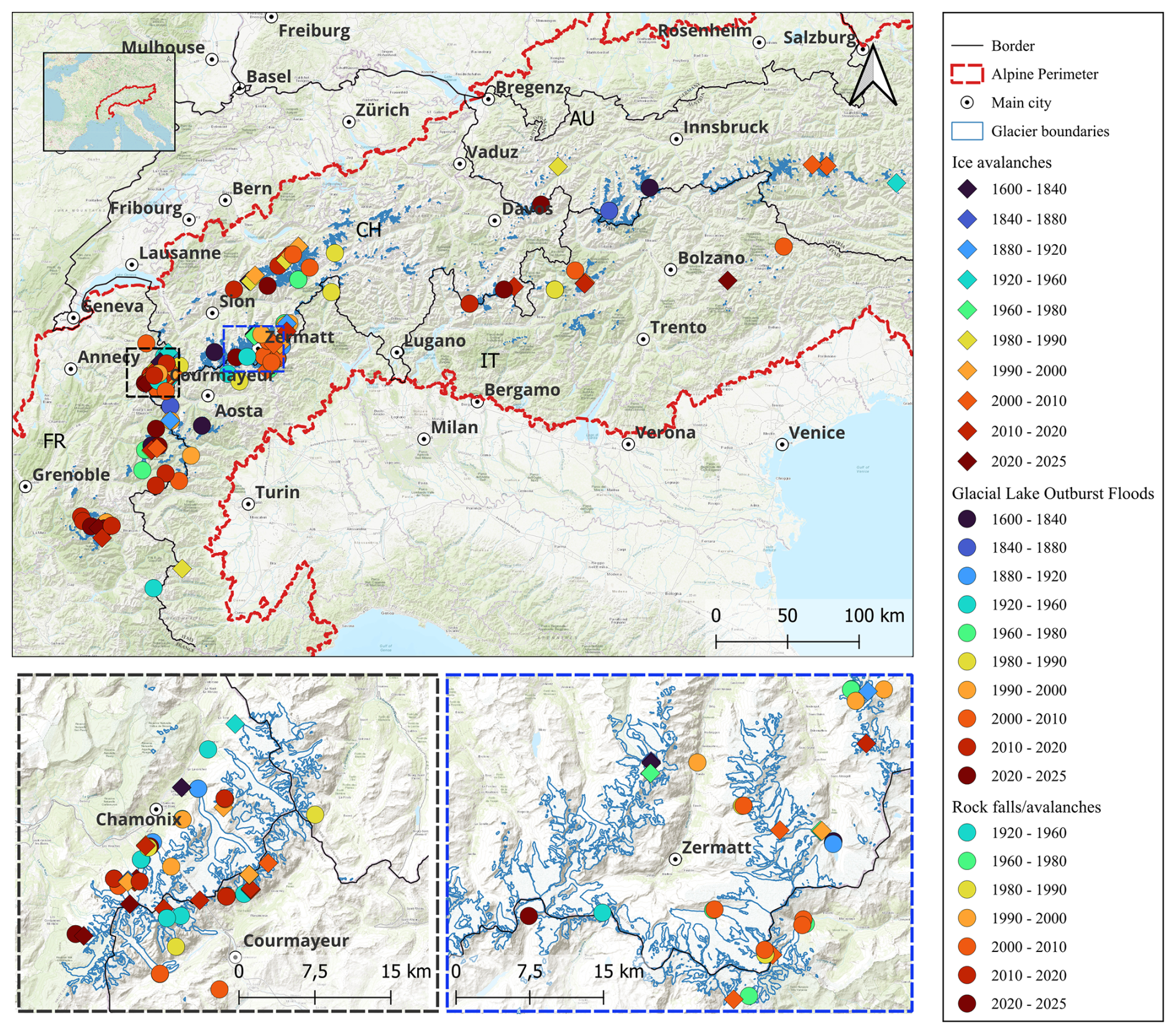
Figure 1Distribution of major glacial and periglacial events inventoried in the Alps. Maps data: ©European Space Agency (2024). Copernicus Global Digital Elevation Model. Distributed by OpenTopography.
3.2.2 Distribution of events according to the eight pillars typology
Once the typology has been established, each event was assigned to the relevant management pillars mobilised in response. Events were then grouped by decade (or by 5-year intervals for rock hazards) to improve temporal readability. This approach highlights changes in management practices over time while limiting visual discontinuities associated with rare events.
This study identifies 200 glacial and periglacial events across 109 Alpine catchment areas in France, Switzerland, Italy, and Austria. These events were selected based on their magnitude, impacts, or influence on the evolution of glacial and periglacial risk management practices.
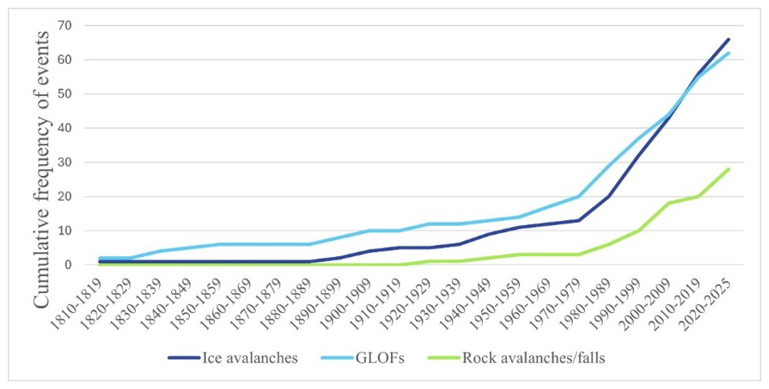
Figure 2Cumulative frequencies of inventoried glacial and periglacial events requiring risk management in the Alps.
4.1 Spatial and temporal distribution of the events
Distribution of the events across the Alps
The spatial distribution of events (Fig. 1) shows a marked concentration in certain areas, highlighting particularly exposed or dynamically active zones. The Mont-Blanc massif (mainly its French and Italian sides) clearly emerges as the most densely affected area, across all hazard types. It is followed by the Valais Alps (CH). GLOFs are also more frequent in the western Alps.
The western Alps high elevations, steep slopes, and extensive glacier cover, making them particularly prone to mass movements. The Mont-Blanc massif and the Valais Alps are among the most monitored and instrumented regions, which may introduce a “visibility bias” (cf. Sect. 5.2). High population density and tourism further enhance event detection and documentation, potentially amplifying their perceived significance.
Figure 1 presents major events that occurred between the 17th century and today, revealing the long-term dynamics of these hazards. They are not isolated events but part of long-term, sometimes recurring trajectories. This representation shows that multiple hazard types coexist within the same Alpine massifs, increasing the complexity of risk management.
4.2 Distribution of management pillars over time
4.2.1 Phenomena intensification
Keeping in mind potential source and event biases (cf. Sect. 5), we nevertheless observe an intensification of hazardous glacial and periglacial events since the 1980s across all Alpine countries (Fig. 2). This trend is based solely on events that required risk management and contributed to hazard understanding.
4.2.2 Evolution over time of the pillars used
This section examines how risk management and prevention methods have evolved over time through significant glacial or periglacial events. Events are analysed according to the management pillars mobilised at the time.
For the three types of events, Pillars 2 (Preventive information) and 3 (Land use planning) appear only from the 1990s onward, while Pillar 6 (Crisis preparedness) has been implemented more recently. Pillar 1 (Hazard understanding) remains the most consistently used. It also continues to be applied retrospectively, as past events are reanalysed to improve risk knowledge.
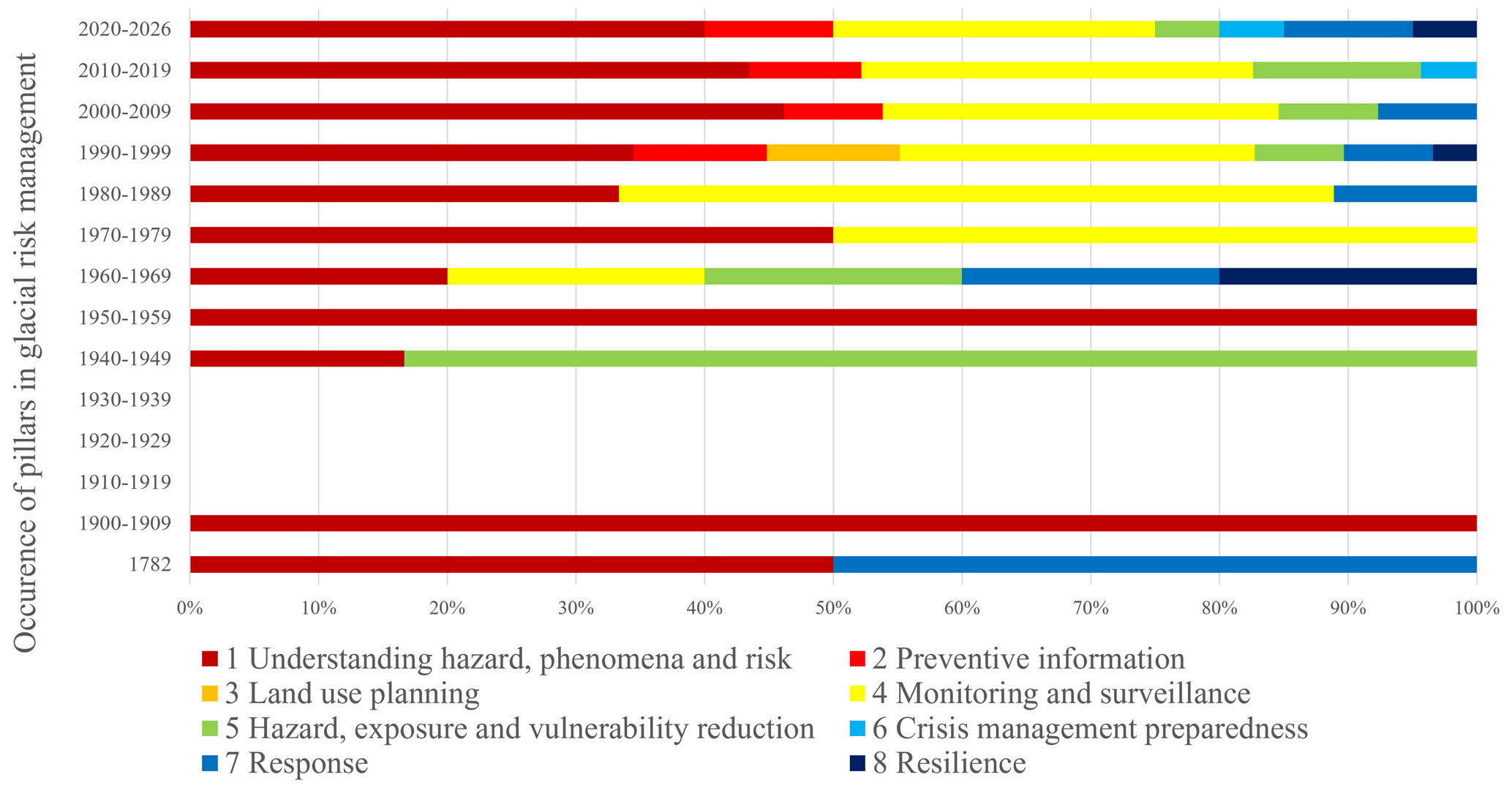
The evolution over time of risk management associated with major ice avalanche events in the Alps is presented in Fig. 3. The graph shows two main phases: a long period (1597–1950) dominated almost exclusively by Pillar 1 (Understanding hazard), followed by a gradual and accelerating diversification of management approaches from the 1950s and 1960s onwards.
The Altels ice avalanche (CH) in 1895 marked a turning point in the recognition of the need to understand high-altitude hazards. This avalanche was of exceptional size, with 4 × 10⁶ m3 of ice breaking away, killing six people and burying 170 cattle over an area of 1 km2 (Du Pasquier, 1896). For a long time, this event served as a benchmark for ice avalanches. “To what extent can we predict such disasters, and to what degree will we be able to prevent them from happening again? Many Alpine glaciers give rise to avalanches or ruinous debacles. (…) The same glaciers periodically give rise to the same phenomena, so it is above all empirical knowledge of these phenomena that we need to acquire. (…) An accurate knowledge of the dangerous points and the phenomena that occur there is absolutely necessary. The era of independent personal research is over; it has produced all it could in this field (…). What is needed now is more coordination, more method, more consistency in research” (Du Pasquier, 1896).
The predominance of Pillar 1 over several centuries should not be interpreted as a lack of institutional response to glacial and periglacial hazards. It rather reflects the fact that, within the epistemic and institutional context of the time, the production of knowledge and the documentation of phenomena constituted the primary and legitimate form of risk management. At that time, management was largely confined to the academic sphere (naturalists, cartographers, scientific academies), long before it became integrated into engineering and spatial planning. This observation suggests that contemporary categories of risk management should not be retrospectively applied to these periods. If preventive information (Pillar 2) appears late, this indicates that decision-makers only gradually began to communicate simplified risk information to exposed populations. This development is closely linked to the emergence of crisis preparedness (Pillar 6). It also raises the question of the role assigned to local communities in risk management, which has long remained expert-driven, with limited structured communication with residents. The example of the Val Ferret (IT), where the terminal tongue of the Planpincieux glacier has been monitored since 2014, illustrates this evolution. Monitoring is coupled with rapid civil protection responses and public information measures (Giordan et al., 2020; Dematteis et al., 2024). The aim is to continuously track glacier dynamics, and detect instability, and activate procedures such as road closures or village evacuation.
This study also integrates avalanche hazard maps, such as the Carte de Localisation des Phénomènes d'Avalanche (CLPA; Avalanche Phenomenon Location Maps) in France, Catasto valanghe in Aosta valley (Italy), Indication of avalanche hazards (ATH) for Switzerland, Wildbach und Lawinenverbauung (WLV) for Austria, into land-use planning (Pillar 3), even though they primarily address snow avalanches. These maps first emerged in the 1970s, but events such as those at the Bourgeat glacier (FR) in 1984 and 1993 show that ice avalanches can trigger snow avalanches (RTM-ONF, 2000). We therefore consider these mapping tools as addressing combined snow-ice hazards.
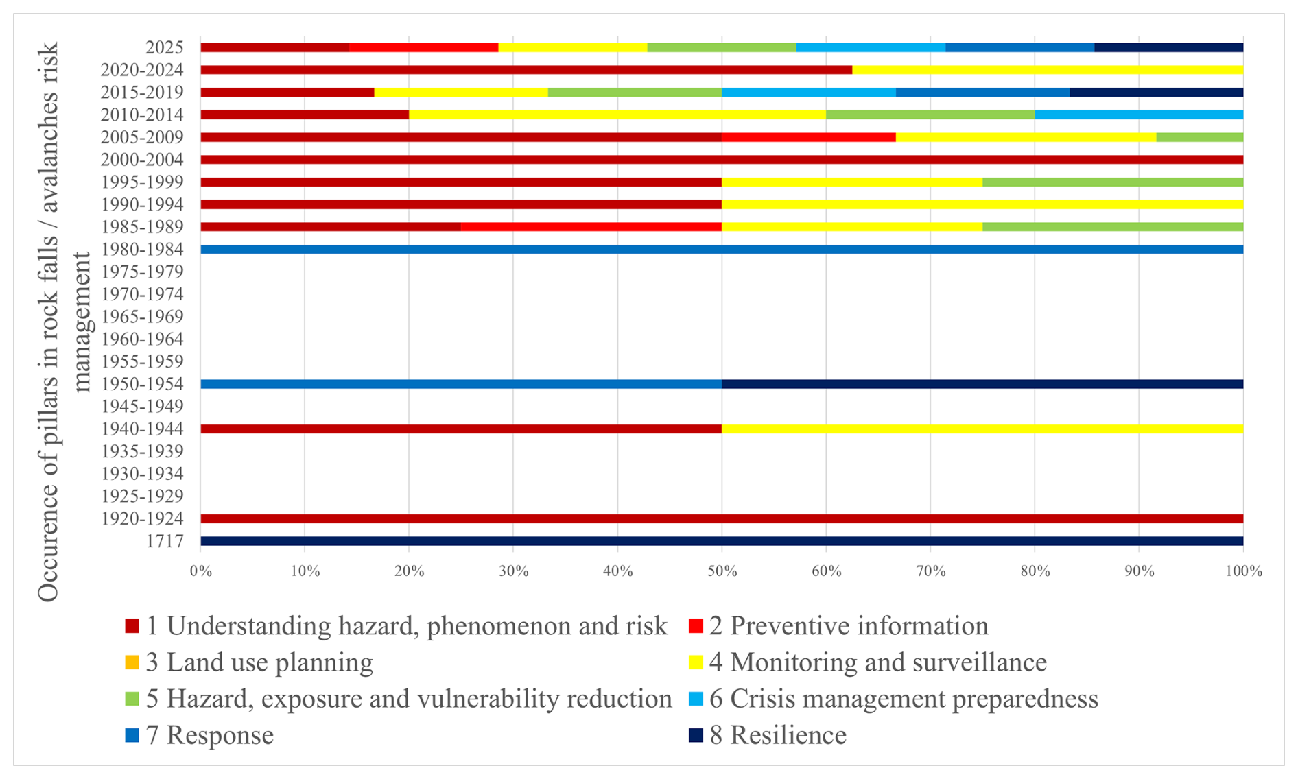
The evolution over time of risk management for major rockfall and rock avalanche events in the Alps is presented in Fig. 4. It is divided into five-year intervals to better highlight recent dynamics, as most rockfall events have occurred since 1980.
The reduction in vulnerability, exposure, and hazard (Pillar 5) is particularly evident in these events. For example, the 1987 Val Pola rockslide (CH; 30 × 106 m3) involved preventive evacuation, illustrating proactive risk management (Chardon, 1990). In 2011, at Piz Cengalo/Bondo (1.5 × 10⁶ m3), preventive measures included public alerts, trail closures, evacuation of alpine buildings, and installation of protective structures (Bohnenblust, 2017).
Monitoring unstable rock faces is a key management tool (Pillar 4). Initially sporadic (1940–1944), it became more systematic from the mid-1980s. Its increasing prominence in recent years (especially 2020–2024) reflects growing investment in instrumental monitoring systems, driven by both the perceived intensification of hazards and advances in measurement technologies. Since 1986, the eastern face of Monte Rosa (IT) has been regularly monitored due to increasing mass movements (Fischer et al., 2006). Other emblematic sites have since been equipped, including Aiguille du Midi (FR) since 2005, the Matterhorn south face (IT) and Les Drus (FR) since 2007.
Finally, projects such as the EU AlpinSpace PermaNET program and the PACE project have contributed to structuring knowledge on Alpine permafrost, through harmonised datasets and coordinated monitoring across the Alps (Harris et al., 2001; Mair et al., 2011).
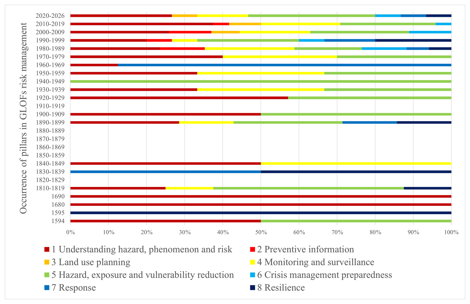
The evolution over time of risk management for major GLOF events in the Alps is presented in Fig. 5. Unlike other hazards, GLOFs are documented as early as the 16th century, reflecting their high visibility and destructing impacts in populated valleys. Their severity ensured systematic recording in administrative and local archives, especially as their transformation into debris flows amplifies downstream damage. The Bagnes valley and the Giétro glacier, for example, generated extensive records from the 16th century onwards due to the scale of the destruction (Ancey et al., 2019).
The period 1850–1889 is absent from the graph, which is paradoxical from a climatic perspective. Although post-Little Ice Age warming favoured lake formation and potentially increased GLOF occurrence, this gap likely reflects missing data rather than reduced activity.
Efforts to reduce vulnerability and exposure appear earlier for GLOFs than for other hazards. Efforts to reduce vulnerability and exposure appear earlier for GLOFs than for other hazards. Early responses relied on direct engineering interventions (drainage, tunnels, dykes) in densely populated valleys, preceding formalised risk management frameworks. This reflects a pragmatic, engineering-driven approach shaped by local socio-economic constraints. Thus, from the late 16th century, recurrent outbursts of the Margherita glacial lake (Rutor glacier, IT) prompted studies commissioned by the Duke of Savoy (12 events between 1430 and 1680; discharge of 5 × 10⁶ m3 in 1751). Technical solutions such as dam and drainage tunnels were already considered in the 19th century (Vergnano et al., 2023).
Another notable example is the Giétro glacier event in 1818. A tunnel was constructed to drain the ice-dammed lake, thereby reducing the magnitude of the floods and preventing major downstream damage (Wiegandt and Lugon, 2008). Also, at the foot of the Gruben Glacier, flood prevention work was carried out at two lakes after the 1970 outburst. For the proglacial lakes, the moraine dams were reinforced with concrete injections; and the thermokarst lake was drained through an artificial channel in 1995 (Haeberli et al., 2001).
These recurrent events progressively led to diversified measures, including dykes, dams, storage basins, subglacial drilling, siphoning, lake drainage, and moraine stabilisation, as well as warning systems. In parallel, glacier monitoring became increasingly formalised, notably through photogrammetric surveys of the Vernagtferner (AU), one of the best-documented glaciers due to its frequent GLOFs, the most notable of which dates back to 1848 (Braun, 1995; Gridabase – Glaciorisk, s. d.).
However, the integration of populations through preventive information is more recent. For instance, the 1986 Arsine proglacial lake case (FR) marked one of the first instances where scientific warning led to coordinated crisis preparedness involving local populations (Laïly and Demolis, 2019).
4.2.3 Disruptive events that have improved the glacial and periglacial risk management and understanding
The construction of a timeline tracing risk management responses to past events has enabled the identification of key turning points marking disruptions and/or the emergence of new approaches. Selected examples correspond to first documented implementations of new management practices (prediction, monitoring, mitigation, and coordinated crisis response).
Scale change
Risk management has shifted from local (village-scale) responses to national frameworks. The Giétro glacier disaster in 1818 illustrates this transition (Ancey et al., 2019). At that time, glaciology was still emerging, yet the event demonstrated that improved process understanding could support more effective interventions. Scientific advances progressively supported the development of preventive measures and favoured the emergence of regional and national policies, replacing earlier reactive local approaches (Wiegandt and Lugon, 2008). The disaster also marked a shift in risk perception, as hazards began to be understood as natural processes rather than divine punishment (Carrivick and Tweed, 2016).
Monitoring and surveillance
The first known glacier inventory in the Alps dates back to the late 19th century (Vernagtferner), an area characterised by frequent GLOFs over the past 400 years (Hoinkes, 1969). Systematic photogrammetric surveys over a century enabled the first detailed analyses of glacier dynamics (Braun, 1995). Monitoring intensified during the 20th century; the Giétro glacier has been monitored since the 1960s, including measurements of flow velocity, structure, and mass balance. More recently, heavily instrumented sites such as the Matterhorn have integrated multi-sensor monitoring systems (Weber et al., 2025) following recurrent instabilities (Occhiena and Pirulli, 2012).
Multidisciplinary network
The 1892 Tête Rousse disaster was a foundational event in glacier risk management. The debris flow has affected several villages downstream, causing 175 victims (Mougin and Bernard, 1922; Cauliez, 2024). It led to the formation of multidisciplinary teams combining engineers, glaciologists, and foresters to investigate causes and implement mitigation measures (Marco et al., 2012; Sirop et al., 2022).
Similarly, the 1965 Allalin glacier collapse at Mattmark (88 fatalities; Vivian, 1966) triggered coordinated scientific and engineering responses (Dalban Canassy et al., 2011). This led to the creation of a national working group on glacier hazards in Switzerland and the development of systematic hazard assessment methods (Haeberli, 1983; Haeberli et al., 2004). A coalition of scientists has irrevocably advanced the understanding of the mechanism of phased glacial rupture and sparked discussion on practical methods of risk assessment at the international level (Huggel et al., 2004).
The Rochemelon lake case further illustrates this coordination. Cross-border collaboration enabled monitoring, risk assessment, public warning, and controlled drainage of the lake (Vincent et al., 2010b). This case highlighted the need for continuity between scientific knowledge, decision-making, and operational action (Marco et al., 2012, unpublished).
Reduction of exposure and vulnerability (evacuations, works, etc.)
The first known organised evacuations for gravitational hazards occurred in 1987 (Val Pola rockslide; 30 × 106 m3; Dramis et al., 1995). Early warnings based on slope instability enabled preventive evacuation (Chardon, 1990). For glacial hazards, evacuations such as Planpincieux (1997) were based on scenario modelling and monitoring data (Margreth and Funk, 1999; Margreth et al., 2011). These approaches marked the emergence of anticipatory risk management. Engineering measures also developed, as illustrated by the Belvedere glacier (IT) and the Effimero lake crisis (2002), where combined strategies (monitoring, mapping, evacuation planning, and artificial drainage) were implemented (Haeberli et al., 2002).
Predictive study
In 1973, the first successful glacier collapse prediction was achieved at Weisshorn (CH) (Röthlisberger, 1981). Scientists observed an acceleration of the upper part of the glacier, accompanied by warnings from local mountain guides (Faillettaz and Funk, 2013). Subsequent advances enabled short-term predictions based on displacement monitoring, such as the Whymper glacier collapse forecast 10 d in advance (Faillettaz et al., 2016). Authorities adapted responses accordingly, restricting access while avoiding unnecessary evacuation. These decisions increasingly relied on modelling and scenario-based approaches (Schindelegger, 2019).
These developments are part of broader research programmes (e.g. Glaciorisk, PERMAdataROC, GlariskAlp, PAPROG), aimed at improving hazard understanding and management.
Institutional risk understanding
Swiss National Research Programmes (NRPs), significantly contributed to the institutionalisation of risk knowledge. Projects under NRP 31, 48, and 61 advanced understanding of climate-driven hazards, spatial planning tools, and emerging glacial lakes (Haeberli et al., 1999, 2016; Rothenbühler, 2006). More broadly, Alpine risk management has evolved from “hazard protection” to “hazard management” and ultimately to “risk management” (Link and Stötter, 2015).
Before 1950, strategies focused on structural protection (protective works) and exposure reduction (legislation). There are numerous traces of such works in 19th century archives. For example, galleries were excavated within the ice of the Allalingletscher glacier in 1834 to lower the level of its lake (dammed by the glacier tongue) and reduce the already high frequency of ice break-offs (Mariétan, 1959). Between 1589 and 1850, documents report 26 major sudden outburst events (Raymond et al., 2003).
After 1950, improved process understanding led to hazard mapping (Link and Stötter, 2015) and probabilistic approaches; this was the age of hazard management.
Since the late 20th century, risk management has adopted a holistic perspective (Link and Stötter, 2015), integrating vulnerability and risk acceptance. Before the 2000s, hazard management was considered in response to an event. Recent approaches increasingly consider cascading processes (e.g. Evans et al., 2009) and multiple scenarios, reflecting the growing complexity of cryospheric hazards under climate change (Allen et al., 2022).
Historically, the scope of hazard assessment has progressively expanded from glacier-related processes to include permafrost degradation and emerging landforms such as proglacial lakes. Current frameworks now adopt integrated, forward-looking approaches that account for long-term cryosphere evolution and cascading risks (Allen et al., 2017).
4.2.4 Proactive vs. reactive management
Our typology of glacial and periglacial risk management distinguishes between proactive and reactive approaches. Management is considered proactive when it relies on anticipatory measures to prevent potential risks. Within the Disaster Risk Management (DRM) framework, prevention, mitigation (including spatial planning, protection measures), long-term adaptation to natural and socioeconomic changes, and the development of response and recovery capacities are all proactive strategies (Tagarev et al., 2021).
Management is reactive when it occurs during or after an event, aiming to manage the emergency, analyse impacts, and improve future risk reduction measures (Tagarev et al., 2021).
The different principles of glacial and periglacial hazards management can operate independently but are often combined. For instance, Monitoring and Surveillance (Pillar 4) is frequently coupled with Exposure, Vulnerability or Hazard Mitigation (Pillar 5).
Regarding torrential hazards associated with glacial lakes, a proactive example is the 1985 warming on the Arsine proglacial lake, which led to partial artificial drainage (Peissier and Courtray, 2012). Similarly, an early warning system installed in 2008 at the Grindelwaldgletscher glacial lake (CH) based on pressure sensors, enabled automatic alerts and proved effective during a drainage event (Bauder, 2017). Or the artificial lowering of the water level of Lake delle Locce and the construction of dams on the main torrent downstream of the Belvedere Glacier (Haeberli and Epifani, 1986).
Conversely, the 1964 overflow of the Patinoire lake (FR), which caused damage downstream as far as the village of Pralognan, prompted a reactive response. Post-event analyses included field surveys, susceptibility studies, and impact modelling, leading to its later designation as a priority monitoring site (Cathala et al., 2021).
The Whymper hanging glacier illustrates proactive management: in 1997, displacement measurements enabled prediction of an imminent collapse, prompting evacuation of Planpincieux (Margreth and Funk, 1999). Continuous monitoring and preparedness measures have since been implemented (Faillettaz et al., 2015, 2016). Similarly, the Forni glacier is monitored using satellite and terrestrial laser scanning to detect instabilities (Fugazza et al., 2018).
In contrast, the 1965 Mattmark disaster (Allalin glacier) exemplifies reactive management. Authorities focused on emergency response and post-event investigation. The event later triggered political debate and highlighted the limits of predictability at the time (Ricciardi, 2016).
For rock avalanches, the Piz Cengalo case illustrates the transition from reactive to proactive management. Following a first event in 2011, monitoring systems and protective infrastructure were implemented (Walter et al., 2019). These included a storage basin, protective barriers, and early warning systems enabling rapid evacuation (Bohnenblust, 2017). Legal proceedings are still ongoing regarding the safety precautions taken prior to the event (Joris, 2025).
In 2017, a major rock avalanche and subsequent debris flows (3.1 × 10⁶ m3 ) affected the Val Bondasca. Despite underestimation of flow magnitude, early warning systems and protective measures significantly reduced damage (OECD, 2018). This case demonstrates the effectiveness of combining past-event analysis, monitoring, and preparedness, although some casualties still occurred (Walter et al., 2019).
5.1 Cascading processes affecting increasingly vulnerable populations
As shown by the events documented in this study, chain reactions in glacial and periglacial environments tend to amplify beyond their initial triggering processes (OECD, 2018; Jacquemart et al., 2024), posing increasing challenges for risk management. This trend is closely linked to rising exposure in Alpine region. Mountain valleys have experienced significant urbanisation and infrastructure development in recent decades, increasing pressure on historically exposed areas (Hock and Rasul, 2022). This growing exposure is compounded by systemic vulnerability due to infrastructure interdependence: the destruction of a road, bridge, or energy network during a cascading event can isolate communities and hinder response capacities, as illustrated by La Bérarde in 2024 (Blanc et al., 2024). Risk management systems have long treated hazards separately, but this segmented approach is increasingly inadequate for complex, interacting phenomena affecting multiple components of populated territories. There is therefore a need for integrated and future/scenario-based approaches (Allen et al., 2017, 2022) that model process interactions while accounting for the spatial distribution of populations and infrastructure (Tacnet et al., 2010; Nyberg et al., 2026). These challenges are further intensified by climate change, which increases the likelihood of cascading processes in densely populated Alpine valleys.
5.2 Biases linked to difficulties in compiling an exhaustive inventory of events
Compiling an inventory that aims to be exhaustive according to defined selection criteria entails limitations and requires contextualisation of each event.
5.2.1 The data source effect
The apparent increase in events over time partly reflects biases related to data availability (e.g. Giacona et al., 2017). This data source effect is closely linked to the nature and distribution of information sources. As Giacona et al. (2019) notes, the spatial and temporal distribution of events depends strongly on the structure of the documentary corpus. Each recorded event therefore depends on the quality and diversity of available sources. Scarcity of historical records limits traceability in earlier periods, whereas recent data abundance increases event detection.
The data source effect thus requires careful consideration of variations in documentation volume. For instance, technological advances such as webcam monitoring (e.g. Gornergletscher) generate continuous and detailed observations, increasing the number of recorded events (Huss et al., 2007).
5.2.2 Land use and the event prism
The presence or absence of sources is also influenced by human occupation. The growing presence of people in high mountains – through mountaineering (Mourey et al., 2023) and valley urbanisation (Vannier et al., 2016) – has significantly increased observation capacity. Conversely, abandoned settlements and pastures were once important witnesses to past hazards.
Even when hazards occur, their recognition depends on societal perception. An event may remain unrecorded if it is not perceived as significant. As Giacona et al. (2019) argues, an event gains social existence only when it is perceived as a disruption. Risk perception evolves over time and is shaped by collective experience, knowledge, and social context (Granet-Abisset, 2012). Increasing attention to high-mountain hazards also reflects rising societal expectations for safety and accountability, which in turn drive the production and diversification of information sources.
5.3 Resilience and response as late-developed concepts rather than absent practices
The emergence of Pillar 8 (Resilience) from the 1980s–90s onwards, and its consolidation after 2000, should be interpreted cautiously. It does not indicate a prior absence of resilience from Alpine communities, but rather the late institutionalisation of the concept in scientific and policy frameworks. Post-event reconstruction dynamics existed well before this period, but were not conceptualised within this framework, introducing an interpretative bias in diachronic analysis.
Similarly, Pillar 7 (Response) appears from the 1950s and remains present thereafter, without becoming dominant. Its consistent but limited representation suggests that emergency response has always existed but is less documented due to lower formalisation, leading to potential under-representation in the database.
The use of a ninth separate pillar representing “Experience feedback” was considered, since the experience gained from an event enables a “structured process of capitalising on and utilising knowledge resulting from the analysis of positive and/or negative events” (Villeneuve et al., 2010).
Feedback is the very condition for an event's existence in archives: its narration and memory make it historically visible. It therefore applies to every event, and would have created a bias in relation to the other pillars. Therefore, it is implicitly included in Pillar 1.
5.4 National discrepancies in prevention
The study highlights that risk reduction measures are not uniform across Alpine countries and reveals a geographical bias towards France, Switzerland, and Italy. This heterogeneity reflects significant differences in legislative, institutional, and cultural frameworks for risk management. International cooperation and governance initiatives such as GAPHAZ exist to try to bridge these differences (Allen et al., 2022).
In France, spatial planning relies on binding national regulations, and scientific action plans are also defined at the national level. In Switzerland, management is largely devolved to the cantons, encouraging locally adapted approaches but potentially generating inequalities depending on available resources. In Italy, administrative fragmentation and regional disparities hinder the implementation of coherent policies at the scale of catchments.
These governance differences affect both data comparability and the ability to derive cross-cutting insights. More broadly, they highlight the need for stronger transnational Alpine governance. Given that hazards transcend political borders, enhanced institutional coordination is essential for effective and equitable risk prevention.
This study moves beyond traditional approaches that focus primarily on post-event causes or hazards characterization, and instead examines management practices. While event inventories inform on frequency, they rarely capture organisational dynamics or adaptative capacities. Our analysis addresses these dimensions.
By analysing 200 events since the early 19th century (some even earlier, though less frequent), we observe both an intensification of events and a progressive formalisation of management practices, reflected in archival records. The growing number of simultaneously mobilised pillars in recent years indicates a shift from single-discipline approaches to multi-actor, multi-scale governance. Beyond increased event reporting, this reflects the maturation of institutional Alpine risk management frameworks. Although all high-altitude massifs are affected, our data highlights a concentration of major events in France and western Switzerland, particularly for glaciers, new lakes and permafrost-affected/glacially de-buttressed rock faces. The completeness of this long-term inventory remains constrained by sources and perception biases.
Risk management has evolved in response to both major events and improved process understanding. It continues to rapidly change far beyond historical and empirical antecedence. Forecasting, instrumentation, and monitoring of unstable zones have expanded, alongside contingency planning and evacuation strategies. Measures to reduce exposure and vulnerability increasingly account for evolving hazards and urbanisation pressures. Since the early 21st century, scientific initiatives aimed at anticipating high-mountain mass movements that have multiplied. Knowledge exchange across borders has intensified, supporting more integrated and holistic risk management approaches. Hazards are now increasingly analysed as interconnected or cascading phenomena. As risk management grows more complex, the social sciences emerge as an indispensable complement to natural sciences, bringing to the fore dimensions – community vulnerability, risk perception, territorial identity, institutional dynamics – that physical approaches alone cannot capture.
Switzerland appears as a leading actor in the institutionalisation of monitoring and hazard assessment, particularly for glaciers and rock faces. Multidisciplinary collaboration and international knowledge exchange are rapidly advancing.
Across many regions worldwide, glacial and permafrost environments now differ markedly from the conditions under which settlements and infrastructure developed. Historical and empirical knowledge alone is therefore insufficient to anticipate future glacier- and permafrost-related risks. This calls for integrated, forward-looking approaches, based on continuous observation, repeated expert assessments, and rapidly evolving technologies. Risk analysis must adopt a systemic perspective, covering the full chain from hazard sources to socio-economic impacts.
Raw inventory data is available on data.InDoRES (https://doi.org/10.48579/PRO/JA5PDT, Bazin, 2026).
JB, LR and SC designed the study and JB carried it out. JB prepared the manuscript with contributions from all co-authors.
The contact author has declared that none of the authors has any competing interests.
Publisher's note: Copernicus Publications remains neutral with regard to jurisdictional claims made in the text, published maps, institutional affiliations, or any other geographical representation in this paper. The authors bear the ultimate responsibility for providing appropriate place names. Views expressed in the text are those of the authors and do not necessarily reflect the views of the publisher.
We would like to thank the reviewers of this article, whose assistance has been crucial in enabling us to expand the scope of our research, as well as for the numerous references that have helped to support and clarify our arguments. We would also like to thank the European ALCOTRA 2021–2027 Interreg VI-A PrévRisk-CC project, as well as the French National Research Agency (ANR) through the IRIMONT programme (ANR-22-EXIR-0003), for their support.
This research was funded by Foresee CAPACITES and FEDER PACA Regard d’Altitude 2.
This paper was edited by Yves Bühler and reviewed by Wilfried Haeberli, Christian Huggel, and Fabrizio Troilo.
Alean, J.: Ice Avalanches: Some Empirical Information about their Formation and Reach, J. Glaciol., 31, 324–333, https://doi.org/10.3189/S0022143000006663, 1985.
Allen, S., Frey, H., and Huggel, C.: Assessment of Glacier and Permafrost Hazards in Mountain Regions, Technical Guidance Document, Swiss Agency Dev. Coop. SDCCOSUDE, https://doi.org/10.13140/RG.2.2.26332.90245, 2017.
Allen, S., Frey, H., Haeberli, W., Huggel, C., Chiarle, M., and Geertsema, M.: Assessment Principles for Glacier and Permafrost Hazards in Mountain Regions, in: Oxford Research Encyclopedia of Natural Hazard Science, Oxford University Press, https://doi.org/10.1093/acrefore/9780199389407.013.356, 2022.
Ancey, C., Bardou, E., Funk, M., Huss, M., Werder, M. A., and Trewhela, T.: Hydraulic Reconstruction of the 1818 Giétro Glacial Lake Outburst Flood, Water Resour. Res., 55, 8840–8863, https://doi.org/10.1029/2019WR025274, 2019.
Bauder, A.: The Swiss Glaciers 2013/14 and 2014/15 – Glaciological Report No. 135/136, VAW ETH Zür., Cryospheric Commission (EKK) of the Swiss Academy of Sciences (SCNAT), 145 pp., https://doi.org/10.18752/GLREP_135-136, 2017.
Bazin, J.: Risk management for major glacial and periglacial events in the Alps over the past two centuries, Version V1, data.InDoRES [data set], https://doi.org/10.48579/PRO/JA5PDT, 2026.
Beccera, S. and Peltier, A.: L'information préventive pour réduire la vulnérabilité aux risques d'inondation, élaboration et efficacité d'une réponse sociale, Chang. Clim. Métarisque À Méta-Gouv., 35–53, https://shs.hal.science/halshs-00957904v1/file/Becerra_Peltier_in_Labranche_metarisque_2011.pdf (last access: 18 June 2025), 2011.
Bisquert, A., Mainieri, R., Carladous, S., Robert, Y., Giacona, F., Verry, P., and Eckert, N.: La base de données événementielles RTM pour la connaissance des risques naturels en montagne: L'exemple du département de l'Isère (France), J. Alp. Res. Rev. Géographie Alp., https://doi.org/10.4000/137kf, 2025.
Blanc, A., Misset, C., Mainieri, R., and Llamas, B.: Rétro-analyse de la crue du torrent des Etançons du 21 juin 2024, RTM, https://hal.science/hal-04865442/document (last access: 18 June 2025), 2024.
Bohnenblust, S.: Radar system monitors Pizzo Cengalo, Bondo, GEOPRÆVENT AG – Electron. Monit. Nat. Hazards, https://www.geopraevent.ch/radar-system-monitor-piz-cengalo-bondo/?lang=en (last access: 18 June 2025), 2017.
Bondesan, A. and Francese, R. G.: The climate-driven disaster of the Marmolada Glacier (Italy), Geomorphology, 431, 108687, https://doi.org/10.1016/j.geomorph.2023.108687, 2023.
Boudières, V. and Peisser, C.: Prévention des Risques d'Origine Glaciaire et Périglaciaire (ROGP) – Synthèse des connaissances et des pratiques, PARN, https://risknat.org/wp-content/uploads/2021/08/Synthese_ROGP_PARN_2013.pdf (last access: 18 June 2025), 2013.
Bourrelier, P.-H. and Dunglas, J.: Des événements naturels extrêmes aux figures de la catastrophe, Ann. Mines – Responsab. Environ., 56, 41–47, https://doi.org/10.3917/re.056.0041, 2009.
Braun, L. N.: Les résultats principaux de 100 ans de recherche au Vernagtferner, Oetztal (Autriche), Houille Blanche, 81, 109–110, https://doi.org/10.1051/lhb/1995054, 1995.
Büntgen, U., Oppenheimer, C., Farinotti, D., Nahtz, T., and Esper, J.: The 2025 Blatten disaster in the Swiss Alps followed exceptional warming and highlights the vulnerability of people and heritage in glaciated landscapes, Commun. Earth Environ., 6, 994, https://doi.org/10.1038/s43247-025-02994-8, 2025.
Capozzi, C.: Mémoire de master en histoire – La catastrophe de Mattmark par la presse, Université de Franche-Comté, 2011.
Carrivick, J. L. and Tweed, F. S.: A global assessment of the societal impacts of glacier outburst floods, Global Planet. Change, 144, 1–16, https://doi.org/10.1016/j.gloplacha.2016.07.001, 2016.
Cathala, M., Magnin, F., Linsbauer, A., and Haeberli, W.: Modelling and characterizing glacier-bed overdeepenings as sites for potential future lakes in the deglaciating French Alps, Géomorphologie, 27, 19–36, https://doi.org/10.4000/geomorphologie.15255, 2021.
Cathala, M., Bock, J., Abdulsamad, F., Deline, P., Josnin, J.-Y., Ravanel, L., Revil, A., Richard, J., Verroust, F., and Magnin, F.: Assessing the role of permafrost in the preconditioning and triggering factors of the September 2020 Crête des Grangettes rockfall (southern French Alps), Géomorphologie, 30, https://doi.org/10.4000/12yqn, 2024.
Cauliez, R.: Mémoire M2 – Au-delà des eaux glacées. Pouvoirs gestionnaires et expériences populaires sous le glacier de Tête-Rousse, Ecole Normale Supérieure, 229 pp., 2024.
Chardon, M.: Les catastrophes naturelles de l'été 1987 en Lombardie: crues,inondations, écroulement de Val Pola, Rev. Géographie Alp., 78, 59–87, https://doi.org/10.3406/rga.1990.2767, 1990.
Chiarle, M., Iannotti, S., Mortara, G., and Deline, P.: Recent debris flow occurrences associated with glaciers in the Alps, Global Planet. Change, 56, 123–136, https://doi.org/10.1016/j.gloplacha.2006.07.003, 2007.
Chiarle, M., Viani, C., Mortara, G., Deline, P., Tamburini, A., and Nigrelli, G.: Large glacier failures in the Italian Alps over the last 90 years, Geogr. Fis. E Din. Quat., 45, 19–40, https://doi.org/10.4461/GFDQ.2022.45.2, 2022.
Dalban Canassy, P., Bauder, A., Dost, M., Fäh, R., Funk, M., Margreth, S., Müller, B., and Sugiyama, S.: Hazard assessment investigations due to recent changes in Triftgletscher, Bernese Alps, Switzerland, Nat. Hazards Earth Syst. Sci., 11, 2149–2162, https://doi.org/10.5194/nhess-11-2149-2011, 2011.
Dauphiné, A. and Provitolo, D.: Risques et catastrophes, Armand Colin, https://doi.org/10.3917/arco.dauph.2013.01, 2013.
Davide, F., Antonella, S., Roberto Sergio, A., Carlo, D., Daniele, C. B., Luca, M., Fabiano, V., Claudio, S., and Guglielmina Adele, D.: Variations of Lys Glacier (Monte Rosa Massif, Italy) from the Little Ice Age to the Present from Historical and Remote Sensing Datasets, in: Glaciers and the Polar Environment, edited by: Kanao, M., Godone, D., and Dematteis, N., IntechOpen, https://doi.org/10.5772/intechopen.91202, 2021.
Defossez, S., Vinet, F., and Leone, F.: Diagnostiquer la vulnérabilité face aux inondations: progrès et limites, in: Inondations 1: la connaissance du risque, https://hal.science/hal-03171204v1 (last access: 18 June 2025), 2018.
Dematteis, N., Giordan, D., Troilo, F., Wrzesniak, A., and Godone, D.: Ten-Year Monitoring of the Grandes Jorasses Glaciers Kinematics. Limits, Potentialities, and Possible Applications of Different Monitoring Systems, Remote Sens., 13, 3005, https://doi.org/10.3390/rs13153005, 2021.
Dematteis, N., Troilo, F., Scotti, R., Colombarolli, D., Giordan, D., and Maggi, V.: The use of terrestrial monoscopic time-lapse cameras for surveying glacier flow velocity, Cold Reg. Sci. Technol., 222, 104185, https://doi.org/10.1016/j.coldregions.2024.104185, 2024.
Demolis, B., Kuss, D., and Serrano, C.: Etude du lac de la Patinoire à Pralognan la Vanoise (73), ONF-RTM INRAE, 2021.
Desailly, B.: Crues et inondations en Roussillon: le risque, le discours et l'aménagement, Rev. Géographique Pyrén. Sud-Ouest, 61, 515–519, https://doi.org/10.3406/rgpso.1990.3229, 1990.
Dipartimento della Protezione Civile: Rischio glaciale e periglaciale in ambiente alpino: un quadro metodologico, Prima, 126 pp., https://www.protezionecivile.gov.it/it/pubblicazione/rischio- glaciale-e-periglaciale-ambiente-alpino-un-quadro-metodologico/ (last access: 18 June 2025), 2025.
Dollfus, O. and D'Ercole, R.: Les mémoires des catastrophes au service de la prévision et de la prévention des risques naturels, Economica, 7–18, 1996.
Dosse, F.: Renaissance de l'événement, 1r 'ed., Presses Universitaires de France, https://doi.org/10.3917/puf.dosse.2010.01, 2010.
Dramis, F., Govi, M., Guglielmin, M., and Mortara, G.: Mountain Permafrost and Slope Instability in the Italian Alps: the Val Pola Landslide, Permafrost Periglac. Process., 6, 73–82, 1995.
Du Pasquier, L.: L'avalanche du glacier de l'Altels le 11 septembre 1895, Ann. Géographie, 5, 458–468, https://doi.org/10.3406/geo.1896.5954, 1896.
Einhorn, B.: Changement climatique et risques naturels – Prévention, Gestion intégrée, Adaptation, https://risknat.org/wp-content/uploads/2021/08/2017_Einhorn_Atelier_Risques_ADAMONT_PARN.pdf (last access: 18 June 2025), 2017.
Einhorn, B. and Peisser, C.: Gestion intégrée du risque généré par les poches d’eau du glacier de Tête Rousse – De la tragédie de 1892 à la gestion de crise de 2010, Pôle Alpin d’Etude et de Recherches pour la Prévention des Risques Naturels, Grenoble, https://risknat.org/wp-content/uploads/2021/08/Actes_Tete-Rousse_20-04-2011-2.pdf (last access: 18 June 2025), 2011.
Etzelmüller, B., Guglielmin, M., Hauck, C., Hilbich, C., Hoelzle, M., Isaksen, K., Noetzli, J., Oliva, M., and Ramos, M.: Twenty years of European mountain permafrost dynamics—the PACE legacy, Environ. Res. Lett., 15, 104070, https://doi.org/10.1088/1748-9326/abae9d, 2020.
Evans, S. G., Tutubalina, O. V., Drobyshev, V. N., Chernomorets, S. S., McDougall, S., Petrakov, D. A., and Hungr, O.: Catastrophic detachment and high-velocity long-runout flow of Kolka Glacier, Caucasus Mountains, Russia in 2002, Geomorphology, 105, 314–321, https://doi.org/10.1016/j.geomorph.2008.10.008, 2009.
Faillettaz, J. and Funk, M.: Instabilités glaciaires et prédiction, Société Vaudoise Sci. Nat., 159–174, https://wp.unil.ch/risk/files/2013/11/13_Failletaz_MemSVSN2013_C_Li.pdf (last access: 18 June 2025), 2013.
Faillettaz, J., Funk, M., and Vincent, C.: Avalanching glacier instabilities: Review on processes and early warning perspectives, Rev. Geophys., 53, 203–224, https://doi.org/10.1002/2014RG000466, 2015.
Faillettaz, J., Funk, M., and Vagliasindi, M.: Time forecast of a break-off event from a hanging glacier, The Cryosphere, 10, 1191–1200, https://doi.org/10.5194/tc-10-1191-2016, 2016.
Favier, R.: Sociétés urbaines et culture du risque. Les inondations dans la France d'Ancien Régime, F. Walter, B. Fantini et P. Delvaux. Les cultures du risque (XVIe-XXIe siècle), Genève, Presses d'histoire suisse, 49–86, https://shs.hal.science/halshs-00140935v1 (last access: 18 June 2025), 2006.
Field, C., Barros, V., Stocker, T., and Dahe, Q.: Managing the risks of extreme events and disasters to advance climate change adaption, Cambridge University Press, New York, 582 pp., ISBN 978-1-107-02506-6, 2012.
Fischer, L., Kääb, A., Huggel, C., and Noetzli, J.: Geology, glacier retreat and permafrost degradation as controlling factors of slope instabilities in a high-mountain rock wall: the Monte Rosa east face, Nat. Hazards Earth Syst. Sci., 6, 761–772, https://doi.org/10.5194/nhess-6-761-2006, 2006.
Fischer, L., Purves, R. S., Huggel, C., Noetzli, J., and Haeberli, W.: On the influence of topographic, geological and cryospheric factors on rock avalanches and rockfalls in high-mountain areas, Nat. Hazards Earth Syst. Sci., 12, 241–254, https://doi.org/10.5194/nhess-12-241-2012, 2012.
Fournier, M.: Le riverain introuvable! La gestion du risque d'inondation au défi d'une mise en perspective diachronique: une analyse menée à partir de l'exemple de la Loire, Aménagement de l'Espace et Urbanisme, Université François-Rabelais, Tours, 432 pp., https://www.researchgate.net/publication/305389406_Le_riverain_introuvable_La_gestion_du_risque_d'inondation_au_defi_d'une_mise_en_perspective_diachronique_Une_analyse_menee_a_partir_de_l'exemple_la_Loire (last access: 18 June 2025), 2010.
Francese, R. G., Valentino, R., Haeberli, W., Bondesan, A., Giorgi, M., Picotti, S., Pettenati, F., Sandron, D., Ramponi, G., and Valt, M.: Failure of Marmolada Glacier (Dolomites, Italy) in 2022: data-based back analysis of possible collapse mechanisms, Nat. Hazards Earth Syst. Sci., 25, 3027–3053, https://doi.org/10.5194/nhess-25-3027-2025, 2025.
Fugazza, D., Scaioni, M., Corti, M., D'Agata, C., Azzoni, R. S., Cernuschi, M., Smiraglia, C., and Diolaiuti, G. A.: Combination of UAV and terrestrial photogrammetry to assess rapid glacier evolution and map glacier hazards, Nat. Hazards Earth Syst. Sci., 18, 1055–1071, https://doi.org/10.5194/nhess-18-1055-2018, 2018.
GeoClimAlp: Inventory of High-Altitude Mass Movements in the Italian Alps, GeoClimAlp Research Group, https://geoclimalp.irpi.cnr.it/landslide-inventory/#6/43.659/13.554, last access: 4 March 2026.
Giacona, F., Eckert, N., and Martin, B.: A 240-year history of avalanche risk in the Vosges Mountains based on non-conventional (re)sources, Nat. Hazards Earth Syst. Sci., 17, 887–904, https://doi.org/10.5194/nhess-17-887-2017, 2017.
Giacona, F., Martin, B., Eckert, N., and Desarthe, J.: Une méthodologie de la modélisation en géohistoire: de la chronologie (spatialisée) des événements au fonctionnement du système par la mise en correspondance spatiale et temporelle, Physio-Géo, 14, 171–199, https://doi.org/10.4000/physio-geo.9186, 2019.
Giardino, M., Ratto, S., Alberto, W., Armand, M., Cignetti, M., and Navillod, E.: Regional and local risk assessments of alluvial fans by combination of historical and geomorphological data on debris flows, the most damaging natural hazard in the Aosta Valley Region (NW-Italy), EGU General Assembly, Vienna, Austria, 2–7 May 2010, Vol. 12, 2010.
Giordan, D., Dematteis, N., Allasia, P., and Motta, E.: Classification and kinematics of the Planpincieux Glacier break-offs using photographic time-lapse analysis, J. Glaciol., 66, 188–202, https://doi.org/10.1017/jog.2019.99, 2020.
Girard, S. and Rivière-Honegger, A.: Le choix et la pratique de la monographie diachronique. Contribution à l’étude de l’efficacité environnementale de la territorialisation de la politique de l’eau., in: Environnement, politiques publiques et pratiques locales, Harmattan, 359–384, ISBN 978-2-343-06657-8, 2015.
Granet-Abisset, A.-M.: L'historien, les risques et l'environnement: un regard sur la nature et les hommes, in: 23èmes Journées Scientifiques de l'Environnement – Risques environnementaux: détecter, comprendre, s'adapter, https://hal.science/hal-00797134 (last access: 18 June 2025), 2012.
Gridabase – Glaciorisk: SMS/Nimbus, Glaciorisk European Project, https://www.nimbus.it/glaciorisk/gridabasemainmenu.asp, last access: 27 May 2025.
Gruber, S. and Haeberli, W.: Permafrost in steep bedrock slopes and its temperature-related destabilization following climate change, J. Geophys. Res.-Earth, 112, 2006JF000547, https://doi.org/10.1029/2006JF000547, 2007.
Haeberli, W.: Frequency and Characteristics of Glacier Floods in the Swiss Alps, Ann. Glaciol., 4, 85–90, https://doi.org/10.3189/S0260305500005280, 1983.
Haeberli, W. and Epifani, F.: Mapping the Distribution of Buried Glacier Ice – An Example From Lago Delle Locce, Monte Rosa, Italian Alps, Ann. Glaciol., 8, 78–81, https://doi.org/10.3189/S026030550000118X, 1986.
Haeberli, W., Kääb, A., Hoelzle, M., Bösch, H., Funk, M., Mühll, D., and Keller, F.: Eisschwund und Naturkatastrophen im Hochgebirge, vdf Hochschulverlag an der ETH Zürich, Zürich, 190 pp., ISBN: 978-3-7281-2617-7, 1999.
Haeberli, W., Kääb, A., Mühll, D. V., and Teysseire, P.: Prevention of outburst floods from periglacial lakes at Grubengletscher, Valais, Swiss Alps, J. Glaciol., 47, 111–122, https://doi.org/10.3189/172756501781832575, 2001.
Haeberli, W., Kääb, A., Paul, F., Chiarle, M., Mortara, G., Mazza, A., Deline, P., and Richardson, S.: A surge-type movement at Ghiacciaio del Belvedere and a developing slope instability in the east face of Monte Rosa, Macugnaga, Italian Alps, Nor. Geogr. Tidsskr. – Nor. J. Geogr., 56, 104–111, https://doi.org/10.1080/002919502760056422, 2002.
Haeberli, W., Huggel, C., Kääb, A., Gruber, S., Noetzli, J., and Zgraggen-Oswald, S.: Development and perspectives of applied research on glacier and permafrost hazards in high-mountain regions – the example of Switzerland, “High mountain hazard prevention”, 2004.
Haeberli, W., Buetler, M., Huggel, C., Friedli, T. L., Schaub, Y., and Schleiss, A. J.: New lakes in deglaciating high-mountain regions – opportunities and risks, Climatic Change, 139, 201–214, https://doi.org/10.1007/s10584-016-1771-5, 2016.
Harris, C., Haeberli, W., Vonder Mühll, D., and King, L.: Permafrost monitoring in the high mountains of Europe: the PACE Project in its global context, Permafr. Periglac., 12, 3–11, https://doi.org/10.1002/ppp.377, 2001.
Hock, R. and Rasul, G.: The Ocean and Cryosphere in a Changing Climate: Special Report of the Intergovernmental Panel on Climate Change, 1st edn., Cambridge University Press, https://doi.org/10.1017/9781009157964, 2022.
Hoinkes, H. C.: Surges of the Vernagtferner in the Ötztal Alps since 1599, Can. J. Earth Sci., 6, 853–861, https://doi.org/10.1139/e69-086, 1969.
Hugerot, T., Astrade, L., Gauchon, C., and Ployon, E.: De la carte diachronique à la trajectoire géohistorique: modélisation du changement paysager d'un cône torrentiel, Mappemonde, 132, https://doi.org/10.4000/mappemonde.6704, 2021.
Huggel, C., Haeberli, W., Kääb, A., Bieri, D., and Richardson, S.: An assessment procedure for glacial hazards in the Swiss Alps, Can. Geotech. J., 41, 1068–1083, https://doi.org/10.1139/t04-053, 2004.
Huggel, C., Fischer, L., Schneider, D., and Haeberli, W.: Research advances on climate-induced slope instability in glacier and permafrost high-mountain environments, Geogr. Helv., 65, 146–156, https://doi.org/10.5194/gh-65-146-2010, 2010.
Huggel, C., Carey, M., Clague, J. J., and Kääb, A.: The high-mountain cryosphere: environmental changes and human risks, Cambridge University Press, Cambridge, United Kingdom, 363 pp., ISBN 978-1-107-06584-0, 2015.
Huss, M., Bauder, A., Werder, M., Funk, M., and Hock, R.: Glacier-dammed lake outburst events of Gornersee, Switzerland, J. Glaciol., 53, 189–200, https://doi.org/10.3189/172756507782202784, 2007.
Intergovernmental Panel On Climate Change (IPCC) (Ed.): Annex I: Glossary, in: Climate Change 2022 – Mitigation of Climate Change, Cambridge University Press, 1793–1820, https://doi.org/10.1017/9781009157926.020, 2023.
IPCC: Global Warming of 1.5 °C: IPCC Special Report on Impacts of Global Warming of 1.5 °C above Pre-industrial Levels in Context of Strengthening Response to Climate Change, Sustainable Development, and Efforts to Eradicate Poverty, 1st edn., Cambridge University Press, https://doi.org/10.1017/9781009157940, 2022.
IPCC: Climate Change 2022 – Impacts, Adaptation and Vulnerability: Working Group II Contribution to the Sixth Assessment Report of the Intergovernmental Panel on Climate Change, 1st edn., Cambridge University Press, https://doi.org/10.1017/9781009325844, 2023.
Jacquemart, M., Weber, S., Chiarle, M., Chmiel, M., Cicoira, A., Corona, C., Eckert, N., Gaume, J., Giacona, F., Hirschberg, J., Kaitna, R., Magnin, F., Mayer, S., Moos, C., Van Herwijnen, A., and Stoffel, M.: Detecting the impact of climate change on alpine mass movements in observational records from the European Alps, Earth-Sci. Rev., 258, 29, https://doi.org/10.1016/j.earscirev.2024.104886, 2024.
Joffe, H. and Orfali, B.: De la perception à la représentation du risque: le rôle des médias, Hermès, 41, 121, https://doi.org/10.4267/2042/8962, 2005.
Joris, E.: Mattmark 1965: Erinnerungen, Gerichtsurteile, italienisch-schweizerische Verflechtungen, 1. Auflage., Rotpunktverlag, Zürich, ISBN 978-3-03973-072-8, 2025.
Kellerer-Pirklbauer, A., Slupetzky, H., and Avian, M.: Ice-avalanche impact landforms: the event in 2003 at the glacier nördliches bockkarkees, hohe tauern range, austria, Geogr. Ann. Ser. Phys. Geogr., 94, 97–115, https://doi.org/10.1111/j.1468-0459.2011.00446.x, 2012.
Kienholz, H., Krummenacher, B., Kipfer, A., and Perret, S.: Aspects of Integral Risk Management in Practice – Considerations with Respect to Mountain Hazards in Switzerland, Österreichische Wasser-und Abfallwirtschaft, 45–50, 2004.
Lacroix, D., Mayet, L., and Roche, P.-A.: Risques d'origine glaciaire et périglaciaire – Elements en soutien à un plan d'action, IGEDD – IGA – IGESR, https://www.enseignementsup-recherche.gouv.fr/sites/default/files/2023-08/rapport-21-22-315a-28938.pdf (last access: 18 June 2025), 2022.
Laïly, B. and Demolis, B.: Glaciers blancs à risques – Retours d'expériences sur certaines crises, ONF-RTM, 2019.
Leone, F., Meschinet de Richemond, N., and Freddy, V.: Aléas naturels et gestion des risques, Presses Universitaires de France, 288 pp., 2021.
Link, S. and Stötter, J.: The development of mountain risk governance: challenges for application, Nat. Hazards Earth Syst. Sci. Discuss., 3, 429–455, https://doi.org/10.5194/nhessd-3-429-2015, 2015.
Lucchesi, S., Fioraso, G., Bertotto, S., and Chiarle, M.: Little Ice Age and contemporary glacier extent in the Western and South-Western Piedmont Alps (North-Western Italy), J. Maps, 10, 409–423, https://doi.org/10.1080/17445647.2014.880226, 2014.
Magnin, F., Ravanel, L., Ben-Asher, M., Bock, J., Cathala, M., Duvillard, P.-A., Jean, P., Josnin, J.-Y., Kaushik, S., Revil, A., and Deline, P.: De l'observation des écroulements aux solutions opérationnelles: près de deux décennies d'études sur les risques cryo-gravitaires dans le massif du Mont-Blanc, Rev. Géographie Alp., 111–2, https://doi.org/10.4000/rga.11644, 2023.
Mainieri, R., Blanc, A., Astrade, L., Baratier, A., Berthet, J., Deline, P., Le Roy, M., Misset, C., De Montety, F., Robert, Y., and Schoeneich, P.: Les aspects géomorphologiques de la crue torrentielle du torrent des Étançons à la Bérarde du 21 juin 2024, Géomorphologie, 31, https://doi.org/10.4000/14ipc, 2025.
Mair, V., Zischg, A., Lang, K., Tonidandel, D., Krainer, K., Kellerer-Pirklbauer, A., Deline, P., Schoeneich, P., Cremonese, E., Pogliotti, P., Gruber, S., and Böckli, L.: PermaNET – Réseau d'observation du permafrost sur le long terme – Rapport de synthèse, Interpraevent, Klagenfurt, ISBN: 978-3-901164-14-9, 2011.
Marco, O., Laily, B., and Charles, F.: Mesures de protection et contraintes d'ingénierie en milieu glaciaire: expérience des services intervenus sur les cas récents, ONF-RTM, https://risknat.org/wp-content/uploads/2012/03/Synthese_Seminaire_ROGP_PARN1.pdf (last access: 18 June 2025), 2012.
Margreth, S. and Funk, M.: Hazard mapping for ice and combined snowrice avalanches — two case studies from the Swiss and Italian Alps, Cold Reg. Sci. Technol., 30, 159–173, https://doi.org/10.1016/S0165-232X(99)00027-0, 1999.
Margreth, S., Faillettaz, J., Funk, M., Vagliasindi, M., Diotri, F., and Broccolato, M.: Safety concept for hazards caused by ice avalanches from the Whymper hanging glacier in the Mont Blanc Massif, Cold Reg. Sci. Technol., 69, 194–201, https://doi.org/10.1016/j.coldregions.2011.03.006, 2011.
Margreth, S., Funk, M., Tobler, D., Dalban, P., Meier, L., and Lauper, J.: Analysis of the hazard caused by ice avalanches from the hanging glacier on the Eiger west face, Cold Reg. Sci. Technol., 144, 63–72, https://doi.org/10.1016/j.coldregions.2017.05.012, 2017.
Mariétan, I.: Note de sciences naturelles sur la vallée de Saas, Bull. de la Murithienne, 76, 88–102, 1959.
Mendez, A.: Processus: concepts et méthode pour l'analyse temporelle en sciences sociales, Academia Bruylant, Louvain-la-Neuve, ISBN 978-2-87209-984-9, 2010.
Moles, A.: Notes pour une typologie des événements, Communications, 18, 90–96, https://doi.org/10.3406/comm.1972.1261, 1972.
Mougin, P. and Bernard, C.: Étude sur le glacier de Tête-Rousse. Les avalanches en Savoie, Tome, 4, 3–90, 1922.
Mourey, J., Clivaz, C., and Bourdeau, P.: Analyser l’évolution des pratiques sportives en montagne peu aménagée à partir des données de fréquentation des cabanes. Application aux Alpes Valaisannes, Rev. Géographie Alp., 111-1, https://doi.org/10.4000/rga.11110, 2023., 2023.
Niggli, L., Allen, S., Frey, H., Huggel, C., Petrakov, D., Raimbekova, Z., Reynolds, J., and Wang, W.: GLOF Risk Management Experiences and Options: A Global Overview, in: Oxford Research Encyclopedia of Natural Hazard Science, Oxford University Press, https://doi.org/10.1093/acrefore/9780199389407.013.540, 2024.
Nigrelli, G., Chiarle, M., Nuzzi, A., Perotti, L., Torta, G., and Giardino, M.: A web-based, relational database for studying glaciers in the Italian Alps, Comput. Geosci., 51, 101–107, https://doi.org/10.1016/j.cageo.2012.07.027, 2013.
Nigrelli, G., Paranunzio, R., Turconi, L., Luino, F., Mortara, G., Guerini, M., Giardino, M., and Chiarle, M.: First national inventory of high-elevation mass movements in the Italian Alps, Comput. Geosci., 184, 105520, https://doi.org/10.1016/j.cageo.2024.105520, 2024.
Nyberg, L., Cedergren, A., De Herve, M. D. G., Gustavsson, J., Hassel, H., Tehler, H., and Wester, M.: What do we mean with integrated risk management? – A research profiling comparing DRM and other fields of risk management, Int. J. Disast. Risk Re.., 132, 105942, https://doi.org/10.1016/j.ijdrr.2025.105942, 2026.
Occhiena, C. and Pirulli, M.: Analysis of Climatic Influences on Slope Microseismic Activity and Rockfalls: Case Study of the Matterhorn Peak (Northwestern Alps), J. Geotech. Geoenvironmental Eng., 138, 1012–1021, https://doi.org/10.1061/(ASCE)GT.1943-5606.0000662, 2012.
OECD: Progress towards an all-hazards approach to emergency preparedness and response, Nuclear Energy Organisation for Economic Cooperation and Development, Paris, https://www. oecd.org/content/dam/oecd/en/publications/reports/2018/01/tow ards-an-all-hazards-approach-to-emergency-preparedness-and-response_g1g8938d/9789264289031-en.pdf (last access: 18 June 2025), 2018.
Olivieri, L. and Bettanini, C.: Preliminary observation of Marmolada glacier collapse of July 2022 with space-based cameras, Remote Sens. Lett., 14, 21–29, https://doi.org/10.1080/2150704X.2022.2152754, 2023.
ONF-RTM: Revue annuelle des phénomènes d'origines glaciaire et périglaciaire de l'année 2024 Massif des Ecrins – Grandes Rousses, https://hal.science/hal-05443654v1 (last access: 18 June 2025), 2025.
Peissier, C. and Courtray, V.: Séminaire technique – Synthèse et conclusions: Gestion des risques d'origine glaciaire et périglaciaire – PARN, Ministère de l'Ecologie, du Développement Durable, des Transports et du Logement – Direction Générale de la Prévention des Risques, Grenoble – World Trade Center, https://risknat.org/wp-content/uploads/2021/08/Synthese_Seminaire_ROGP_PARN.pdf (last access: 18 June 2025), 2012.
Pigeon, P.: Réflexions sur les notions et les méthodes en géographie des risques dits naturels, Ann. Géographie, 111, 452–470, https://doi.org/10.3406/geo.2002.21624, 2002.
Prudent-Richard, G., Gillet, M., Vengeon, J.-M., and Descotes-Genon, S.: Changements climatiques dans les Alpes: Impacts et risques naturels, ClimCHAlp – Interreg III B Alpine Space, 2008.
Ravanel, L.: Évolution géomorphologique de la haute montagne alpine dans le contexte actuel de réchauffement climatique, Collection EDYTEM. Cahiers de géographie, 8, 113–124, https://doi.org/10.3406/edyte.2009.1078, 2009.
Ravanel, L. and Deline, P.: La face ouest des Drus (massif du Mont-Blanc): évolution de l'instabilité d'une paroi rocheuse dans la haute montagne alpine depuis la fin du petit âge glaciaire, Géomorphologie, 14, 261–272, https://doi.org/10.4000/geomorphologie.7444, 2008.
Ravanel, L. and Deline, P.: Rockfall Hazard in the Mont Blanc Massif Increased by the Current Atmospheric Warming, in: Engineering Geology for Society and Territory – Volume 1, edited by: Lollino, G., Manconi, A., Clague, J., Shan, W., and Chiarle, M., Springer International Publishing, Cham, 425–428, https://doi.org/10.1007/978-3-319-09300-0_81, 2015.
Ravanel, L., Magnin, F., Gallach, X., and Deline, P.: Évolution des parois rocheuses gelées de haute montagne sous forçage climatique, La Météorologie, 111, 34–40, https://doi.org/10.37053/lameteorologie-2020-0090, 2020.
Raymond, M., Wegmann, M., and Funk, M.: Inventar gefãhrlicher Gletscher in der Schweiz, Versuchsanstalt für Wasserbau Hydrologie und Glaziologie der Eidgenõssischen Technischen Hochschule Zürich, Mitteilungen 182, https://ethz.ch/content/dam/ethz/special-interest/baug/vaw/vaw-dam/documents/das-institut/mitteilungen/2000-2009/182.pdf (last access: 18 June 2025), 2003.
Reghezza, M., Leone, F., and Vinet, F.: La vulnérabilité: un concept problématique, in: La vulnérabilité des sociétés et des territoires face aux menaces naturelles – Analyses géographiques, vol. 1, Montpellier III, 35–40, ISBN: 2-84269-727-8, 2006.
Ricciardi, T.: Mattmark, 30 August 1965: A catastrophe that changed Switzerland's perception of Italian migrants, Schweiz. Z. Für Gesch., 66, 401–419, 2016.
Richard, D.: Caractérisation et gestion des risques d'origine glaciaire, CEMAGREF – Unité de recherche ETNA, Grenoble, 2005.
Rickenmann, D. and Zimmermann, M.: The 1987 debris flows in Switzerland: documentation and analysis, Geomorphology, 8, 175–189, https://doi.org/10.1016/0169-555X(93)90036-2, 1993.
Rothenbühler, C.: GISALP – räumlich-zeitliche Modellierung der klimasensitiven Hochgebirgslandschaft des Oberengadins, PhD thesis, University of Zurich, 2006.
Röthlisberger, H.: Eislawinen und Ausbrüche von Gletscherseen, Gletsch. Klima – Glaciers Clim. Jahrb. Schweiz. Naturforschenden Ges. Wiss. Teil, 170–212, https://ethz.ch/content/dam/ethz/special-interest/baug/vaw/vaw-dam/documents/forschung/glaziologie/gletscher-naturgefahren/monitoring-changes-of-allalingletscher/roethlisberger1981.pdf (last access: 18 June 2025), 1981.
RTM-ONF: Révision partielle du Plan de Prévention des Risques Naturels Prévisibles, ONF-RTM, Chamonix-Mont-Blanc, https://www.chamonix.fr/wp-content/uploads/2024/10/ppri_rapport.pdf (last access: 18 June 2025), 2000.
Schindelegger, A.: Natural hazard risk governance – Report on the state of the Alps, Alpine Convention, https://www.alpconv.org/fileadmin/user_upload/Publications/RSA/RSA7_EN.pdf (last access: 18 June 2025), 2019.
Schindelegger, A. and Kanonier, A.: Natural Hazard Risk Governance: Status Quo in the EUSALP Region, EUSALP Action Group 8, Wien, https://risknat.org/wp-content/uploads/2021/08/natural_hazard_risk_governance_study_EUSALP_GA8-1.pdf (last access: 18 June 2025), 2019.
Schneiderbauer, S. and Ehrlich, D.: Risk, hazard and people's vulnerability to natural hazards - a review of definitions, concepts and data, European Comission, https://www.researchgate.net/publication/268149143_Risk_Hazard_and_People's_Vulnerability_to_Natural_Hazards_a_Review_of_Definitions_Concepts_and_Data (last access: 18 June 2025), 2004.
Sirop, M., Gagliardini, O., Serbource, P., and Bouvier, P.: La prévention des risques du glacier de Tête Rousse: une action pluri-acteurs, Risques Infos, 27–29, 2022.
Stoffel, M., Tiranti, D., and Huggel, C.: Climate change impacts on mass movements — Case studies from the European Alps, Sci. Total Environ., 493, 1255–1266, https://doi.org/10.1016/j.scitotenv.2014.02.102, 2014.
Tacnet, J. M., November, V., Richard, D., and Batton-Hubert, M.: Expertise, décision et incertitude: jusqu'où une approche interdisciplinaire est-elle possible dans le cadre de la gestion intégrée des risques naturels en montagne?, in: Conférence Outils Pour Décider Ensemble 2010 (OPDE), 18 pp., https://hal.science/hal-00558875 (last access: 18 June 2025), 2010.
Tagarev, T., Papadopoulos, G. A., Hagenlocher, M., Sliuzas, R., Ischiwatari, M., and Gallego, E.: Integrating the risk management cycle, in: Science for disaster risk management 2020: acting today, protecting tomorrow, Publications Office, LU, https://doi.org/10.2760/571085, 2021.
Troilo, F., Lodigiani, M., Nicora, M., Perret, P., Christille, J.-M., Calabrese, M., Salvemini, C. B., and Sartor, S.: Monitoring Cryospheric Environment at a Regional Scale: Big Data from Sensor Networks and Experimental AI Applications in the Framework of the Glarisk-cc FESR Project, 2nd Workshop “New Frontiers in Big Data and Artificial Intelligence” (BDAI 2025), https://ceur-ws.org/Vol-4031/14_regular.pdf (last access: 18 June 2025), 2025.
Valette, P. and Carozza, J.-M.: Géohistoire de l'environnement et des paysages, CNRS éditions, Paris, ISBN: 978-2-271-11920-9, 2019.
Vannier, C., Lefebvre, J., Longaretti, P.-Y., and Lavorel, S.: Patterns of landscape change in a rapidly urbanizing mountain region, Cybergeo, 791, https://doi.org/10.4000/cybergeo.27800, 2016.
Vergnano, A., Oggeri, C., and Godio, A.: Geophysical–geotechnical methodology for assessing the spatial distribution of glacio-lacustrine sediments: The case history of Lake Seracchi, Earth Surf. Proc. Land., 48, 1374–1397, https://doi.org/10.1002/esp.5555, 2023.
Villeneuve, E., Pérès, F., and Geneste, L.: An approach to improve risk assessment using experience feedback, in: Proceedings of IFIP Doctoral Spring Workshop “Product and Asset Lifecycle Management”, 1–5, https://hal.science/hal-03757994 (last access: 18 June 2025), 2010.
Vincent, C., Garambois, S., Thibert, E., Lefèbvre, E., Le Meur, E., and Six, D.: Origin of the outburst flood from Glacier de Tête Rousse in 1892 (Mont Blanc area, France), J. Glaciol., 56, 688–698, https://doi.org/10.3189/002214310793146188, 2010a.
Vincent, C., Auclair, S., and Meur, E. L.: Outburst flood hazard for glacier-dammed Lac de Rochemelon, France, J. Glaciol., 56, 91–100, https://doi.org/10.3189/002214310791190857, 2010b.
Vivian, R.: La catastrophe du glacier Allalin, Rev. Géographie Alp., 54, 97–112, https://doi.org/10.3406/rga.1966.3248, 1966.
Walter, F., Amann, F., Kos, A., Kenner, R., Phillips, M., De Preux, A., Huss, M., Tognacca, C., Clinton, J., Diehl, T., and Bonanomi, Y.: Direct observations of a three million cubic meter rock-slope collapse with almost immediate initiation of ensuing debris flows, Geomorphology, 351, 106933, https://doi.org/10.1016/j.geomorph.2019.106933, 2019.
Weber, S., Beutel, J., Dietze, M., Bast, A., Kenner, R., Phillips, M., Leinauer, J., Mühlbauer, S., Pfluger, F., and Krautblatter, M.: Progressive destabilization of a freestanding rock pillar in permafrost on the Matterhorn (Swiss Alps): Hydro-mechanical modeling and analysis, Earth Surf. Dynam., 13, 1157–1179, https://doi.org/10.5194/esurf-13-1157-2025, 2025.
Wiegandt, E. and Lugon, R.: 3 Challenges of Living with Glaciers in the Swiss Alps, Past and Present, in: Darkening Peaks, edited by: Orlove, B., Wiegandt, E., and Luckman, B. H., University of California Press, 33–48, https://doi.org/10.1525/9780520934245-004, 2008.
World Glacier Monitoring Service (WGMS): Fluctuations of glaciers 1985–1990, IAHS (ICSI) – UNEP – UNESCO, https://wgms.ch/downloads/wgms_1993_fogVI.pdf (last access: 18 June 2025), 1993.