the Creative Commons Attribution 4.0 License.
the Creative Commons Attribution 4.0 License.
 | 05 Mar 2026
Mitigating Mazuku hazards: implementation and effectiveness of local dry-gas degassing measures in the Goma area (Virunga Volcanic Province)
Blaise Mafuko-Nyandwi
Mitigation of carbon dioxide diffuse degassing hazards remains underexplored in comparison to other volcanic hazards such as eruptions, despite their persistent and deadly impacts on communities living in active volcanic regions. This study uses a mixed-methods approach – combining quantitative surveys and qualitative interviews – to assess household perceptions of the implementation and effectiveness of risk mitigation measures against mazuku, a locally known hazard caused by emissions of carbon dioxide in the western part of Goma, Virunga Volcanic Province. Data were collected across three sampling zones, capturing demographic characteristics, eruption risk experiences, and perceptions regarding the implementation of mazuku risk mitigation measures.
Findings reveal three locally recognised categories of mitigation measures: (1) emission-limiting measures, such as blocking gas with waste materials; (2) adaptive measures, such as house ventilation or living on upper floors; and (3) awareness measures based on orally transmitted local knowledge such as avoiding mazuku zone early morning. Financial resources, gender and prior risk experience – often linked to length of residence – emerged as significant positive determinants of both motivation and perceived efficacy for the first two categories. Perceptions of awareness measures showed no significant variation across zones even between demographic profile groups. Spatial patterns in perceived implementation and perceived efficacy appear to reflect collective community mitigation implementation rather than based on individual risk mitigation assessment, with some measures perceived as effective despite limited physical evidence of reduced gas concentration.
The study supports the importance of co-creating mitigation strategies with local communities, adapting interventions to socio-economic realities and avoiding the importation of external mitigation measures that may lack contextual relevance. It also calls for complementary research measuring the actual effectiveness of these measures through physical monitoring of mazuku concentrations. These insights, grounded in a Global South context – characterised by rapid uncontrolled urbanisation, offer a valuable perspective for the development of inclusive and effective strategies of carbon dioxide diffuse degassing risk management.
- Article
(9536 KB) - Full-text XML
- Companion paper
- BibTeX
- EndNote


Volcanic hazards are the surface manifestations of Earth's internal activity. They can be short-lived, such as eruptions, or long-term, like carbon dioxide (CO2) diffuse degassing and hydrothermal activities (Loughlin et al., 2015). Despite the dangers posed by these hazards, numerous societies have settled near active volcanoes (Brown and Jenkins, 2017), including in areas with intense CO2 diffuse degassing. Exposition to CO2 diffuse degassing represents a significant threat to human health and safety (Edmonds et al., 2017; Hansell and Oppenheimer, 2004). The CO2, an odourless and colourless gas, acts as an inert asphyxiant and displace oxygen in the air down to dangerously low levels. Lethal concentrations – exceeding 10 vol % – cause rapid loss of consciousness, asphyxiation, and death of human and nonhuman beings (Viveiros and Silva, 2024).
The short-term exposure limit for CO2 is set at 3 vol %, while the permissible limit for an 8 h exposure is 0.5 vol % (Hansell and Oppenheimer, 2004). When these thresholds are exceeded, specific symptoms may appear depending on the concentration level and duration of exposure. These include accelerated breathing and increased heart rate, followed by dyspnoea and headaches, and in more severe cases sweating, dizziness, ringing in the ears, vertigo, vomiting, and muscular weakness (Viveiros et al., 2016). Viveiros and Silva (2024) note that although CO2 diffuse degassing is often considered a neglected natural hazard, it has caused the deaths of more than 2000 people over the past decades. Considering the potential impact of CO2 on human health and its silent infiltration into buildings in diffuse degassing areas, studies on their mitigation measures are crucial to inform disaster risk mitigation programs.
This paper examines the diffuse CO2 degassing (called mazuku) in the Goma area in eastern Democratic Republic of the Congo (DR Congo), located within the Virunga Volcanic Province. Locally in Goma, the term mazuku is derived from Swahili and translates as “evil wind” (or “evil wind that spreads and kills during the night”). It is used to refer both to the diffused CO2-rich gas and the areas where it is emitted. The hazardous gas accumulates in low-lying depressions where they become concentrated due to their heavier-than-air nature (Wauthier et al., 2018). CO2 concentrations in Mazuku can largely exceed the minimum exposure limits for humans or fauna, reaching high concentration ranging from 45 vol % to 80 vol %, with diurnal–nocturnal fluctuations of up to 80 % (Balagizi et al., 2018). The rapid growth of Goma, as observed in many cities of the Global South (Quesada-Román, 2022), has been driven largely by intense migration linked to recurrent armed conflicts in the region and the search for professional opportunities (Pech et al., 2018; Pech and Lakes, 2017). This expansion has extended the city westward into areas highly concentrated in mazuku, thereby exposing a large population.
However, previous mazuku related studies in the region have focused primarily on hazard assessments, including its formation, vent locations, and the geographical distribution of its concentrations (Kasereka et al., 2017; Smets et al., 2010; Wauthier et al., 2018), or evaluating the changes in its magnitude following a volcanic eruption (Vaselli et al., 2003). To date, mazuku mitigation measures are poorly studied. In addition, it has been observed in the region that while official awareness campaigns encourage people to avoid high-risk areas by installing warning panels that call people to avoid settling in mazuku, these signs are frequently removed. Residents continue to stay or others to come and settle in known hazardous zones and subsequently they develop their own local mitigation strategies.
In this perspective, this study seeks to examine household representatives' perceptions regarding the implementation of local mazuku mitigation measures, focusing on their perceived efficacy, associated costs, extent of implementation, and motivations for adoption. To achieve this, the research employs a mixed-methods approach. Qualitative data were collected through 32 interviews and three focus group discussions, identifying, describing, and categorizing 12 principal local mitigation measures. Additionally, a large-scale survey of over 500 households was conducted to evaluate quantitatively public perceptions regarding the implementation of these measures.
This study provides a new perspective on volcanic disaster risk management, highlighting that in a context of scarcity of risk information and mitigation strategies, exposed population developed their own mitigation measures. This makes individual mitigation an imperative if there are no other options for where to live. It means, for instance, when the necessity of settling in volcanic areas with high concentrations of mazuku outweighs the risks of living in regions around Goma affected by armed conflict, the local population seeks to work out practical strategies to mitigate the mazuku hazard and therefore resettle or remain in these high-risk zones. Consequently, hazard mitigation strategies that incorporate local practices prove more effective than those imported from outside (Lutete Landu et al., 2023).
After this introduction, this article provides a detailed overview of mazuku within the human, geological, and geographical context of the Goma region. Then it presents the used methodology and the results followed by a discussion both on the challenges and successes in implementing local mazuku mitigation measures. The paper concludes with key insights and recommendations to strengthen volcanic risk mitigation measures among local communities, drawing on evidence from this case study of Goma.
Goma is located in eastern DR Congo on the northern shore of Lake Kivu (∼ 1460 m a.s.l.), at the international border with Rwanda (Gisenyi), within the Virunga Volcanic Province (VVP) of the western branch of the East African Rift System (Smets, 2016; Vlassenroot and Büscher, 2011). The city is built entirely on the active lava field of Mount Nyiragongo (3470 m a.s.l.), situated about 18 km north of Goma inside Virunga National Park (Fig. 1). Nyiragongo is a rift-controlled stratovolcano with a summit crater of about 1.2 km width and a semi-persistent lava lake (Barrière et al., 2022). Fractures and eruptive fissures on its southern flank strongly control lava pathways (Kervyn et al., 2024). Historical flank eruptions (1977, 2002 and 2021) produced highly fluid lava flows directed towards Goma and the Lake Kivu basin (Kervyn et al., 2024; Smets, 2016). In addition to lava flows, the region is exposed to other volcanic hazards. These include persistent SO2-rich plumes that can degrade air quality and promote acid deposition (Smets et al., 2017), diffuse CO2 degassing (Smets et al., 2010), and recurrent seismicity (Subira Muhindo, 2024) and ground deformation linked to magma intrusions along rift structures (Geirsson et al., 2017; Smittarello et al., 2022). Furthermore, lake Kivu contains large amounts of dissolved carbon dioxide (CO2) and methane (CH4), which represent a potential limnic gas-release hazard in case of lake destabilisation (Hirslund and Morkel, 2020).
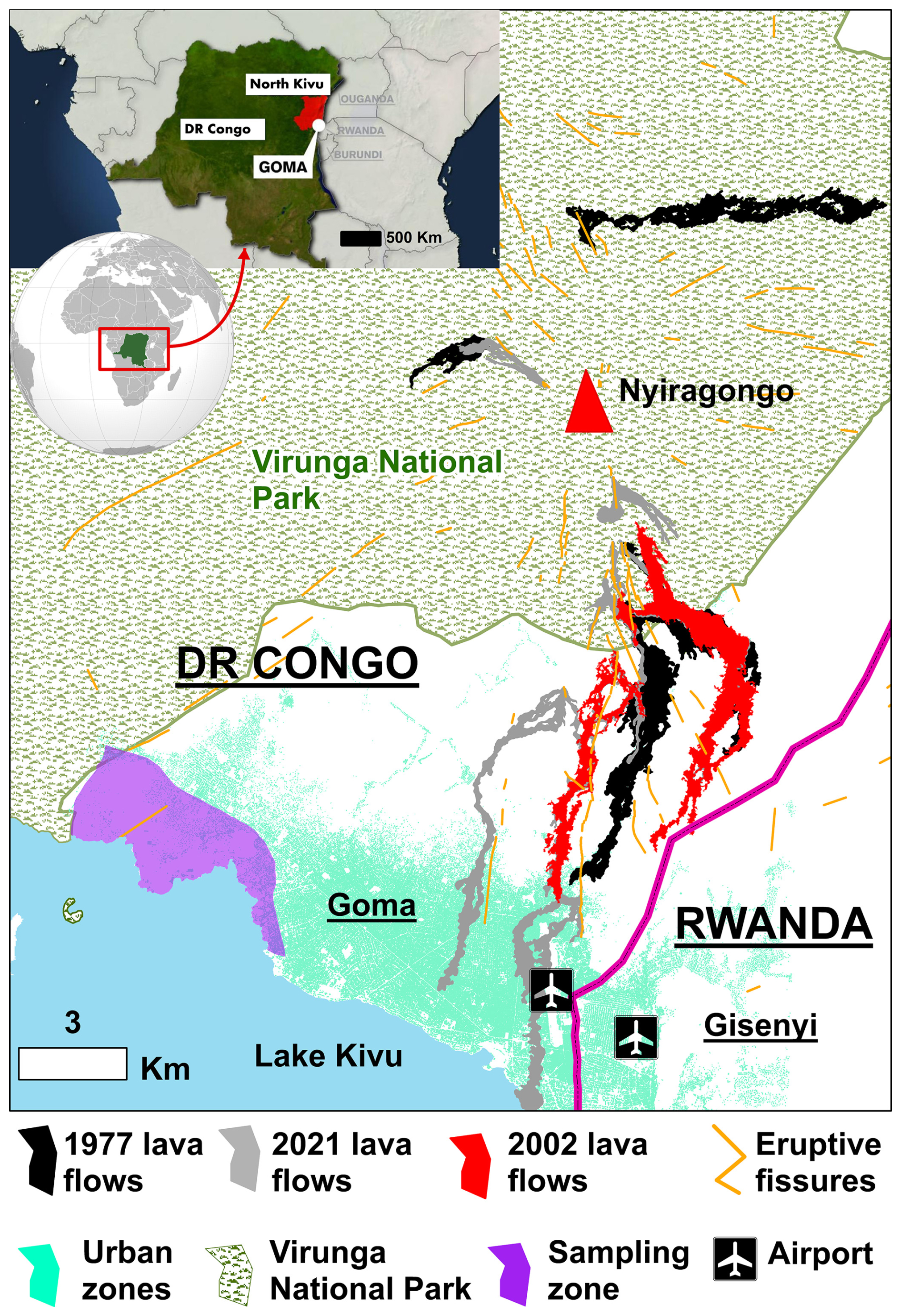
Figure 1Study area of the mazuku zone within the Nyiragongo lava flows (Goma, eastern DR Congo). The map shows the extent of the 1977, 2002 and 2021 lava flows, eruptive fissures, urban areas, and the sampling zone investigated in this study. Part of shapefiles credit: GeoRiskA (https://georiska.africamuseum.be/, last access: 24 May 2025).
Despite its exposure to multiple natural hazards, Goma is a rapidly expanding border city whose urban development has been strongly shaped by ongoing conflict, the presence of the humanitarian sector, and cross-border trade – including natural-resource economics (Pech et al., 2018; Vlassenroot and Büscher, 2009). Populations repeatedly seek refuge mostly from insecurity affecting surrounding areas of eastern DRC. These dynamics have contributed to intense and largely informal urbanisation (Pech et al., 2018). Between 2002 and 2020, the city's population doubled from around half a million to more than 1 million inhabitants, increasing settlement density and demand for housing and services (Adalbert et al., 2021). At the same time, the city's physical expansion is strongly constrained by Lake Kivu to the south, Virunga National Park to the northwest and the Rwanda border to the east, forcing growth northwards towards Nyiragongo's flanks and recent lava fields even in mazuku-affected area (Fig. 1),
The Mazuku-affected area under study, which is now inhabited (Fig. 1), was unoccupied three decades ago (Pech et al., 2018). At that time, the region was covered by an open woodland typical of the area. According to testimonies gathered from local elders, people used to cross it at dusk to reach the lake Kivu for fishing, or early in the morning when returning with their catch. It also served as a hunting ground for Gambian rats and as pastureland for livestock before it was settled. These activities mostly took place in the evening or early morning when the mazuku concentration is high. Therefore, many people, as well as livestock, lost their lives asphyxiated, which was then regarded as an evil wind – one that had neither a smell nor a visible form (Vaselli et al., 2003). Today, the area is inhabited by new residents and Internally Displaced Persons (IDP) with a more urban lifestyle than the earlier inhabitants and the term was kept.
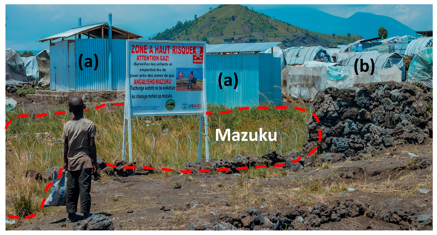
Figure 2Picture of warning panel. The Mazuku emission zone is outlined with red dotted lines, and in the middle stands a warning panel located within an IDP camp. The inscriptions on the warning panel are in French, with a Swahili translation, reading: “High-risk zone. Beware of gas. Watch over and prevent children from playing near gas areas.” Nearby, we can also observe (a) public latrines with uncemented septic pits, and (b) small tent shelters occupied by the IDPs (photo credit: Blaise Mafuko-Nyandwi).
Mazuku denotes depressions into which dense CO2 – heavier than air – emanates and accumulates (Fig. 2). Such phenomena also occur in other volcanic areas around the globe, including Mammoth Mountain (USA), Royat (France), and the Siena Graben (Italy); however, they differ in terms of both gas origin mechanisms and patterns of human occupancy(Edmonds et al., 2017; Hansell and Oppenheimer, 2004). Despite their long-standing recognition, the formation mechanisms of these gases remain poorly understood and widely debated (Williams-Jones and Rymer, 2015).
In the VPP they are common in the vicinity of Goma – particularly between Lake Kivu and the west part of lava flow fields of Nyiragongo and Nyamuragira (Smets et al., 2010). Wauthier et al. (2018) explain that these occur where a deep magmatic CO2 source connects to the surface via a network of fractures, and where topographical depressions enable the gas to settle. The expansion of Goma has led to the occupation of lakeshore areas in the west of the city, along Lake Kivu (Büscher and Vlassenroot, 2010; Pech et al., 2018), where theses mazuku are highly concentrated. The official mitigation strategy involves mapping gas-emission zones and installing warning panels. Nonetheless, these mazuku continue to cause fatalities over extended periods, and livestock asphyxiation remains a frequent occurrence.
3.1 Data collection
This study adopted a sequential mixed-methods design integrating qualitative and quantitative approaches (Fig. 3). We first conducted semi-structured interviews in neighbourhoods previously identified by the Goma Volcanological Observatory (GVO) as mazuku emission zones to document local experiences and identify existing mitigation measures. We then organised three focus group discussions (with community representatives, street leaders, and manual septic-pit diggers) to validate, clarify, and categorise the measures and refine contextual understanding of their implementation. Finally, insights from these qualitative steps informed the construction of a questionnaire survey, which was administered at scale to quantitatively assess household perceptions of the identified measures, particularly regarding perceived effectiveness, costs, levels of implementation, and motivations for adoption. In this study, street leaders refer to locally recognised neighbourhood-level representatives who coordinate 10 households and facilitate communication between residents and local authorities.
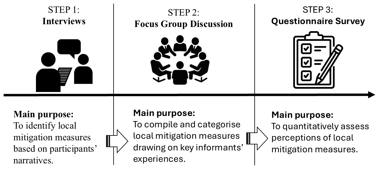
Figure 3Sequential mixed-methods design showing the intersections between qualitative interviews, focus group discussions, and the questionnaire survey used to identify, validate, categorise, and quantitatively assess local mazuku mitigation measures. Icons credit: Shutterstock (https://www.shutterstock.com/, last access: 24 December 2025).
3.1.1 The interviews
The interviews were conducted between 1 and 10 October 2024. We interviewed 32 individuals – 17 women and 15 men – focusing exclusively on adult household heads. Participants were selected at random, with an aim of interviewing three people per main street: one at the beginning, one in the middle, and one at the end. The entire area identified by the Goma Volcanological Observatory as a high-risk mazuku zone was covered. Verbal consent was obtained from all participants prior to the interviews. The interviews were structured and addressed the following themes: (1) the respondent's experience of volcanic risk in Goma; (2) their knowledge of the existence and formation of mazuku; (3) indicators used to identify areas with high mazuku concentrations; (4) impacts recorded as a result of mazuku exposure; and (5) mitigation measures against mazuku-related risks.
3.1.2 Focus groups
In addition to the interviews, we organised three focus group discussions (FGD) towards the end of October 2024. The FGDs covered the same themes as the interviews but adopted a debate-based approach among participants to identify the spatial and daily temporal variations in the occurrence of mazuku. The first FGD brought together 10 participants, including 5IDPs and local residents. The aim was to capture differences in perception between the various social groups living in the same area. The second FGD comprised 8 men who manually dig septic pits. They work in the area extracting stones for sale as well as digging toilet septic pits. They are familiar with the history of land occupation and are well aware of the areas with high gas concentrations, although without any scientific assessment of the levels. This discussion enabled the oral history of the area's occupation to be reconstructed.
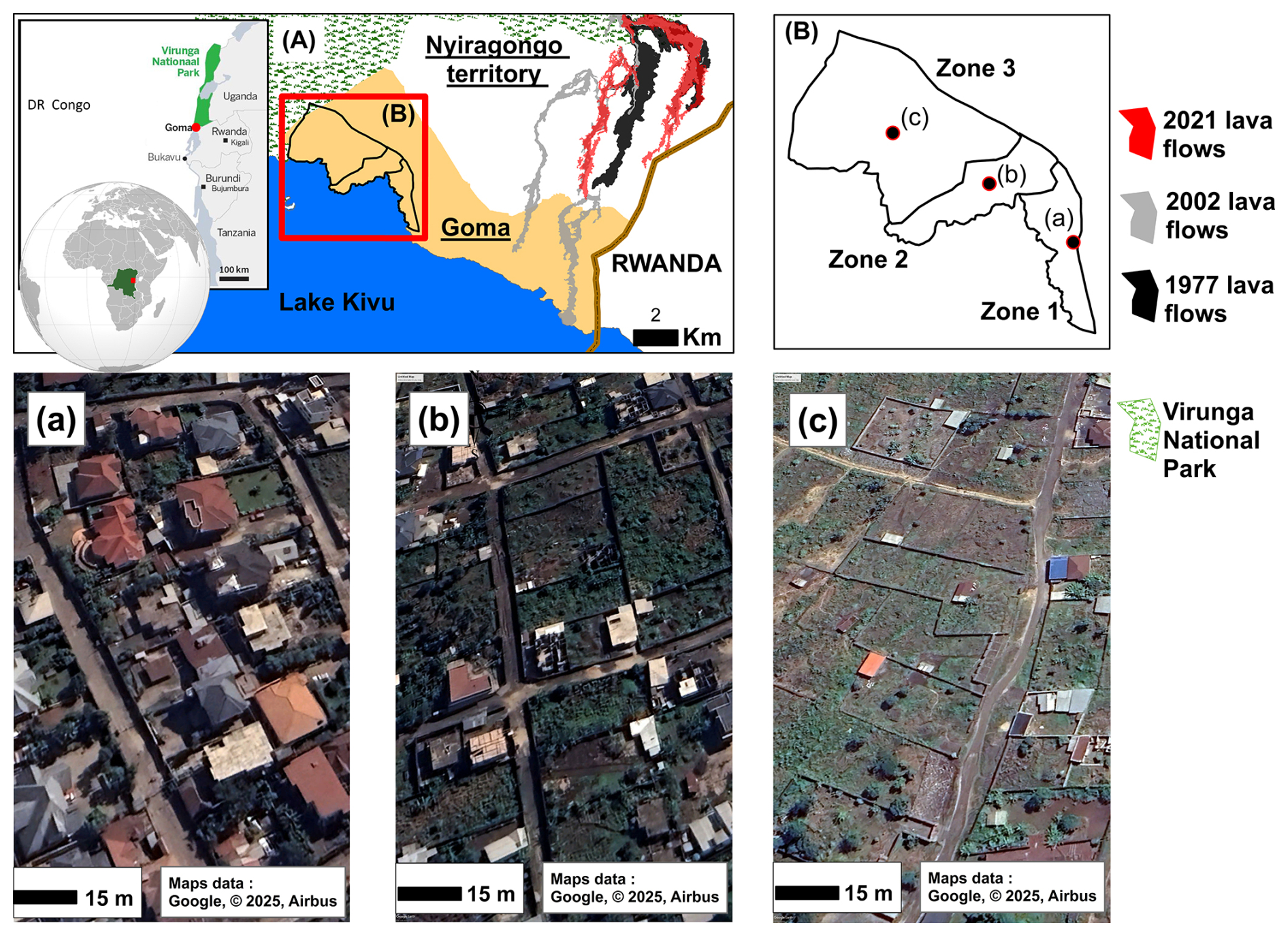
Figure 4Maps of the Study Area: map (A) shows the location of the city of Goma, and the lava flows from the last three eruptions of Nyiragongo. Map (B) indicates the three sampling zones and the pattern of housing structures, derived from Google Earth.
Finally, we brought together 9 street leaders to discuss the same themes, with a stronger focus on local mechanisms for managing this risk. The FGDs concluded with a walk-through in the area for observations involving 4 street leaders, 3 diggers, and 3 community members who were available. This exercise allowed us to distinguish 3 types of land occupation according to the nature of the houses and the period of settlement (Fig. 4): a highly urbanised area occupied by high-income residents; a transitional area undergoing urbanisation with sporadic permanent constructions; and a rural area mainly inhabited by indigenous populations and IDPs.
3.1.3 Questionnaire survey
The data gathered from qualitative evaluations enabled us to describe and classify 12 risk mitigation measures (Mafuko Nyandwi, 2025). Subsequently, we conducted a large-scale survey – carried out by trained enumerators – to assess population perception regarding the implementation of these measures.
The questionnaire focused on:
-
Demographic profile: including participants' age, gender, experience with risk, household size, monthly household income, number of rooms in the house, duration of residence, and residential status.
-
Perceptions of measure implementation: covering respondents' individual motivation to implement each mazuku mitigation measure over the next 6 months; the perceived efficacy of each measure in reducing risk across within their neighbourhood; the perceived cost of implementation; and finally, how they perceived the current level of implementation of each measure within their neighbourhood.
The sample size was determined based on the population of the Goma targeted neighbourhoods (Kyeshero and Lac Verts). With an estimated population of approximately 100 000 – according to data collected from the respective neighbourhoods offices during our survey – our sample of 573 individuals at a 95 % confidence level far exceeded the minimum required for statistical representativeness (Morgan, 1970).
We randomly distributed around 600 sampling points over a Landsat image from Google Earth, across the identified high-risk mazuku zone, maintaining an approximately equidistant spacing of 40 m between points. Enumerators were instructed to survey the household closest to each sampling point, following a previous developed protocol (Mafuko Nyandwi et al., 2023a). We targeted only adult household heads as respondents.
3.2 Data analysis
The qualitative data were analysed using content analysis to list all mazuku mitigation measures, followed by thematic analysis to identify recurring patterns and key themes related to their implementation and categorisation. We then employed descriptive statistics to characterise the measures by evaluating the proportion of the population at each level of perception. Cronbach's alpha was used to measure internal consistency across the three categories of mitigation measures, enabling us to aggregate motivation and perceived efficacy within each group. Aggregation was performed using the mean when the coefficient of variation (CV) was less than 25 %, and the median when the CV was 25 % or higher – the CV, being the ratio of standard deviation to the mean, provides a standardised measure of variability.
Non-parametric tests were applied to assess how motivation for implementation varied across demographic variables. Statistically significant variations were represented on boxplots. Pairwise Spearman's rank-order correlations were calculated to evaluate the strength and direction of monotonic relationships between ranked variables – motivation, perceived efficacy, and perceived cost – and the results were visualised using bar charts that display the correlation coefficient for each pair. Finally, chi-square tests were conducted to evaluate spatial variations in aggregated efficacy and the level of implementation of each measure across the three sampling zones.
4.1 Demographic profile of participants
Our survey targeted only adult household heads (Table 1). The majority of these heads were under 45 years of age (77.31 %), with the majority of respondents being women (61.78 %). Households are large. Over 80 % have between 4 and 10 members. Despite this large household size, the average monthly income per household remains very low, with 58.12 % of households living on around USD 150 per month and 28.97 % on an income of between USD 151 and 300. This situation is even more pronounced in zone 3, where almost all households (91.5 %) live on less than USD 150 per month. Zone 3 is more unusual in that it is home to more displaced people from the wars than the other zones. Zone 1, which is located further east, i.e. on the city centre side, has the lowest proportion of war-displaced people (8.9 %). Generally speaking, the western part of Goma that we surveyed had a high rate of new arrivals. 62.13 % had lived there for less than 5 years and 22.16 % for between 6 and 11 years.
4.2 Description of mitigation measures
Through the analysis of interview discourse, we identified 12 key local strategies for mazuku risk mitigation. Additionally, follow-up focus group discussions, held in a participatory manner, enabled the classification of these measures into three categories based on whether they aim to prevent mazuku, reduce its impact, or inform the population of it occurrences.
For preventing mazuku emission, on the one hand, local residents explained that they use household waste mixed with mud to cover areas emitting mazuku (measure 1), hoping to reduce gas emission. On the other hand, households with sufficient financial means tend to cement all potential emission points within their plots with concrete, such as house floors (measure 2), courtyards (measure 3), and septic systems (measure 4).
We use household waste mixed with mud to cover the mazuku areas, hoping to reduce the emissions, especially when the mazuku is located in a public area … These zones are already known to us, so we organise regularly community works to prevent or reduce the mazuku emissions.
(Elderly man, street leader, 16 years living in a mazuku zone)
Some houses have uncemented floors, so mazuku emissions can occur in bedrooms or living rooms … When households have the financial means, they cement all potential emission sources like septic tanks or backyards. But for public spaces, we mostly use household waste.
(27-year-old woman, born, raised, and now married in the same mazuku area)
When it is not possible to prevent the emission of mazuku, local communities have developed adaptive strategies and or convey local knowledge – passed down orally from generation to generation and also between long-time residents to newcomers – to help avoid high-risk areas within neighbourhoods or in public areas.
To cope with high concentrations of mazuku within their homes, residents elevate beds (measure 1), live on upper floors when available (measure 2), or improve ventilation by enlarging windows and keeping them open during the day or sometimes at night (measure 3). In cold conditions, certain households reported heating courtyards or indoor areas to facilitate the dispersion of mazuku (measure 4). In addition, to keep the wider community informed about mazuku occurrences, residents raise awareness about avoiding known mazuku zones. They are encouraged to work together with officials from the volcanic observatory and civil protection to install warning signs and follow their instructions (measure 1). Furthermore, based on experience, it is best to avoid mazuku particularly in the early morning (measure 2) or after rainfall (measure 3). For those raising livestock or poultry, it is recommended that animals be kept in very well-ventilated areas (measure 4). Descriptive statistics further characterise these measures by examining individual perceived motivation, response efficacy, associated costs, and levels of implementation.
4.2.1 Level of perception of blocking gas emission measures
Measures aimed at blocking mazuku emissions that require greater financial resources – such as cementing different parts of the household environment – were evaluated similarly by the population (Fig. 5). The majority perceive these measures as costly, although nearly all agree that they are effective or very effective. Their perceived high cost may explain the mixed views when it comes to households to evaluate their motivation for their implementation. Among this group of measures, the highest proportion (53 %) of respondents reporting a high or very high motivation to implement relates to the use of household waste – a measure which, as expected, is perceived by the majority (68 %) as having low or very low cost and perceived to be largely implemented in the zone
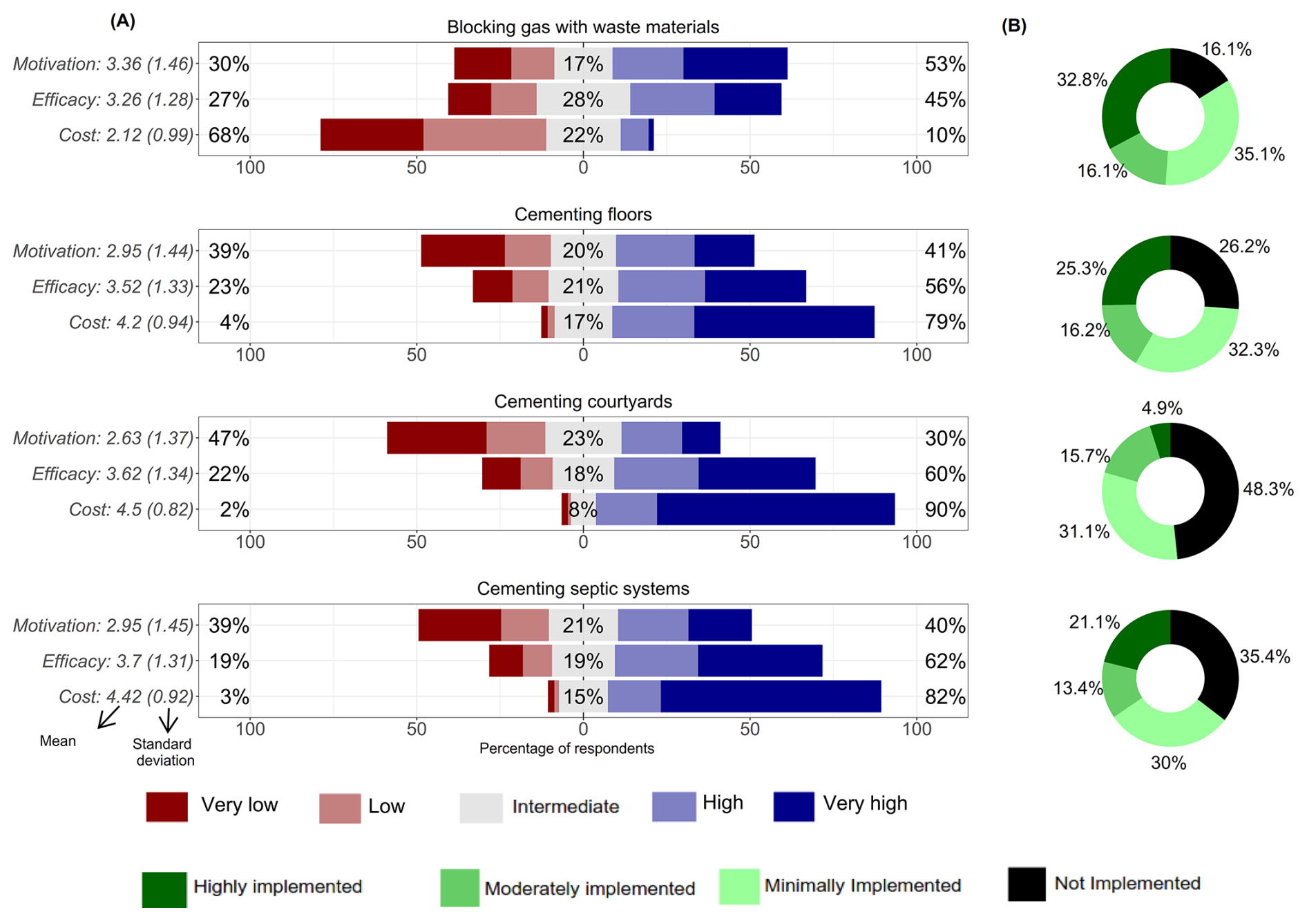
Figure 5(A) Level of perceptions of different indicators for blocking gas mitigation measure. The percentages on the left indicate the proportion who perceived this likelihood as low or very low, while the middle percentages represent those with a moderate perception of likelihood. (B) The level of implementation.
4.2.2 Level of perception of adaptive mitigation measures
Opinions are divided when it comes to evaluating the motivation, perceived efficacy, and even the cost associated with measures such as raising the bed level or improving house ventilation (Fig. 6). Yet, among these adaptation strategies, these two are the most widely implemented in the region. The least implemented are heating the courtyard or living upstairs. An elder from the neighbourhood offers insight into why:
We burn dry grass or sometimes cardboard boxes from nearby shops – especially when the cold persists for over 24 h – to help evaporate the mazuku. Living upstairs is certainly better, but not everyone can afford it. My neighbour, who has an upper-floor dwelling, told me that all the bedrooms are upstairs to avoid being caught unawares at night by a high mazuku concentration. On particularly cold days, he said that his family decide outright not to stay on the ground floor at all.
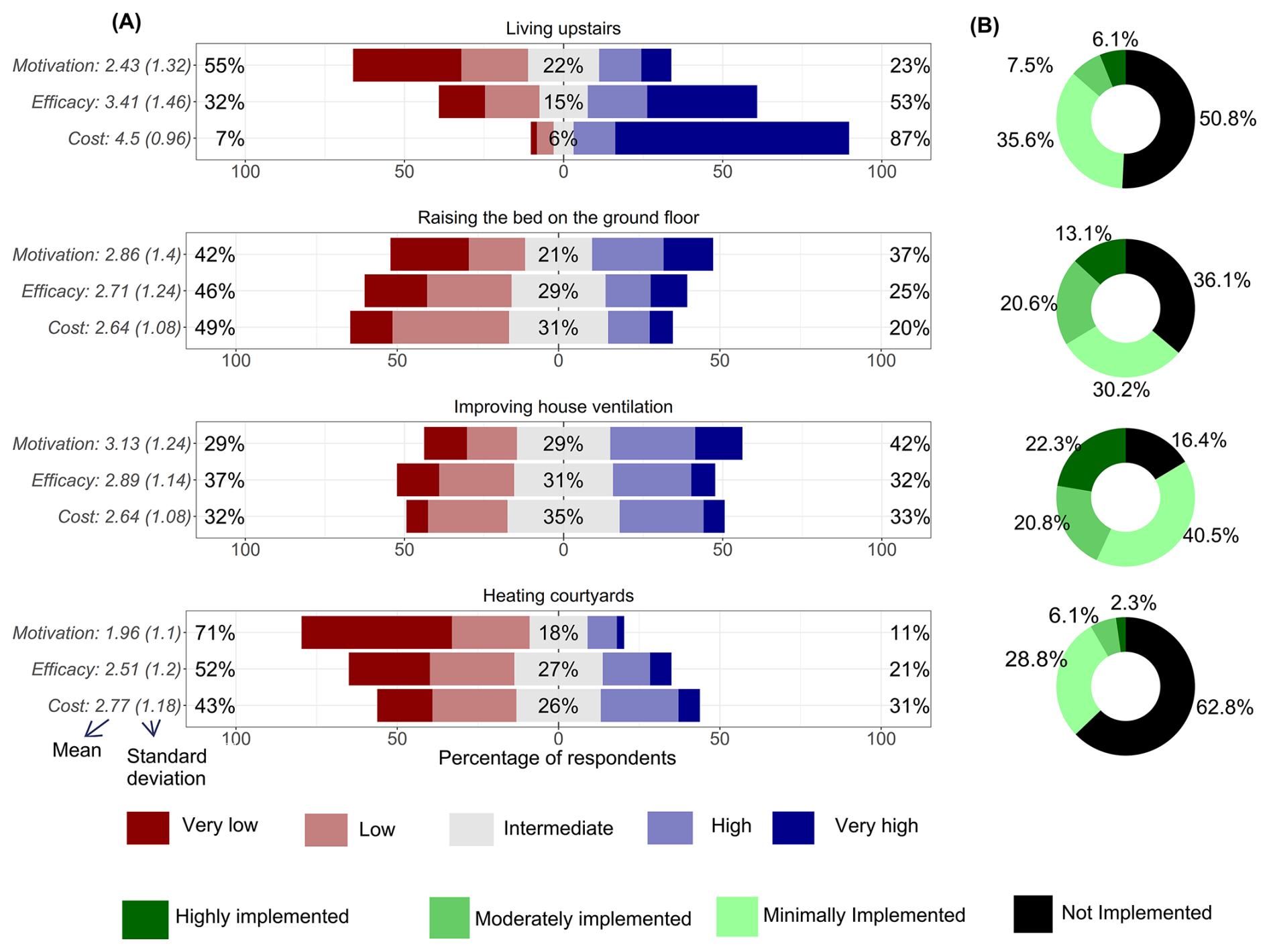
Figure 6(A) Level of perceptions of different indicators for adaptative mitigation measure. (B) The level of perceived implementation within the neighbourhood.
4.2.3 Level of perception of community based awareness measures
Knowing which areas have high concentrations of mazuku – so as to avoid them in the early morning, during rain, or simply when temperatures drop during the day – is among the most widely implemented measures (Fig. 7). Approximately 85 % of the population report that these two measures are effective and they are motivated to implement them. As might be expected, nearly everyone surveyed – around 90 % – perceive their implementation cost to be very low, which may explain why they are so frequently adopted.
Mazuku incidents tend to be more concentrated in the evening or early morning, and when the temperature is low especially during the rainy seasons. You cannot see the mazuku or detect any odour, but sometimes, on a path, you suddenly feel suffocated as though someone were pressing on your chest, and you cannot breathe. At that moment you must act quickly and leave the area while you still have strength ….
Just after the dry season – at the beginning of September when children return to school – the first critical period begins and lasts until December. It is followed by a second critical period during the second rainy season, from February to May every year. These periods are particularly hazardous because they coincide with the school term, when children have to leave home early for classes.
In this context, we do our best to inform our children, newcomers or everyone in the neighbourhood, about the locations of these mazuku zones: we encourage them to identify them and to stay well away from them, especially when it is cold.
(A mother of 4 children at primary school, 13 years of residence in the area)
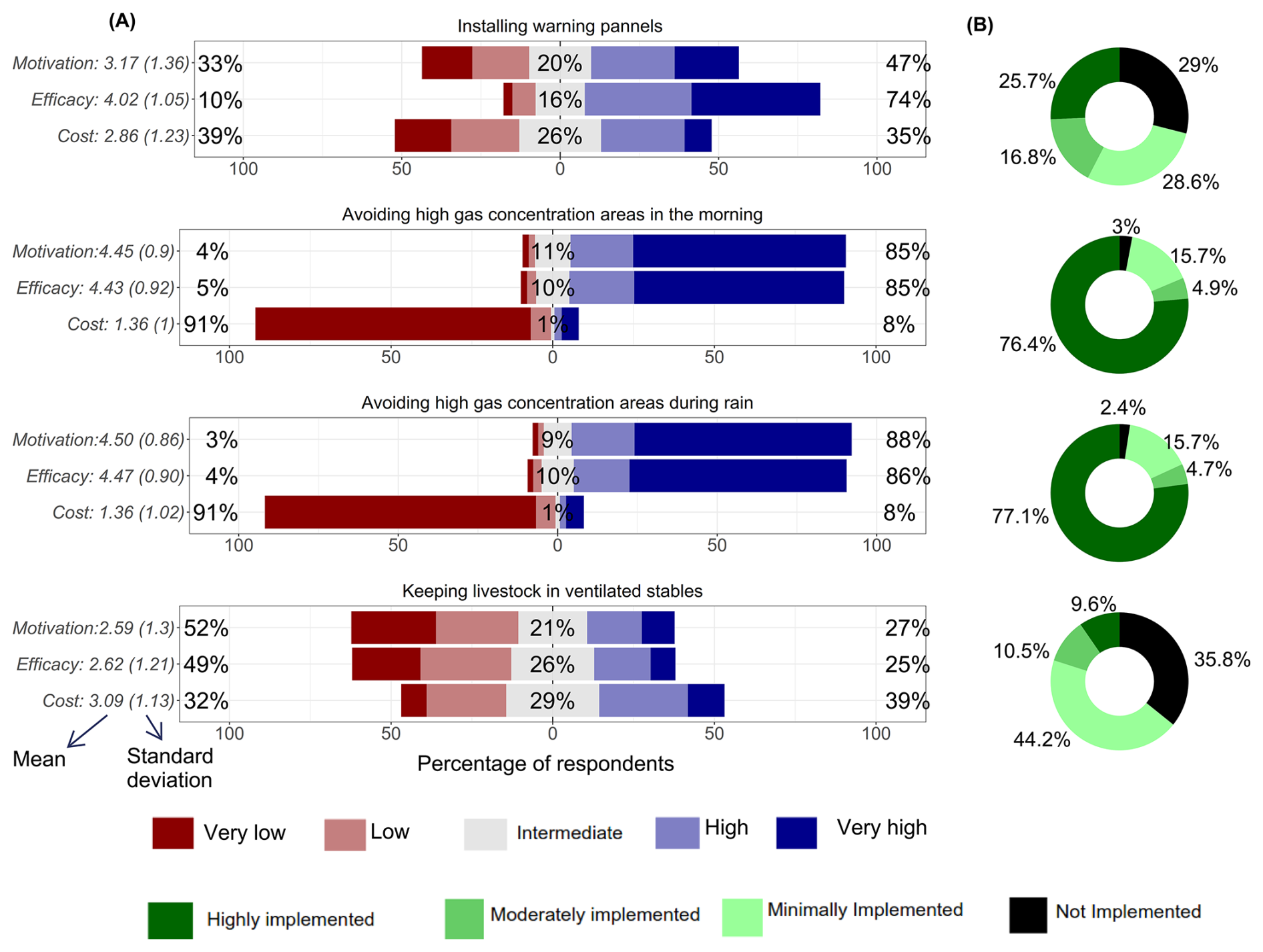
Figure 7(A) Level of perceptions of different indicators for Community based awareness measures. (B) The level of perceived implementation within the neighbourhood.
A significant proportion of respondents (75 %) believe that installing panels is effective in reducing the risk of mazuku exposure; however, opinions remain divided when it comes to motivation to implement or the cost of installation. Similarly, views are mixed regarding the measure of keeping livestock or poultry in well-ventilated spaces.
4.3 Factors of the motivation for implementing mitigation measures
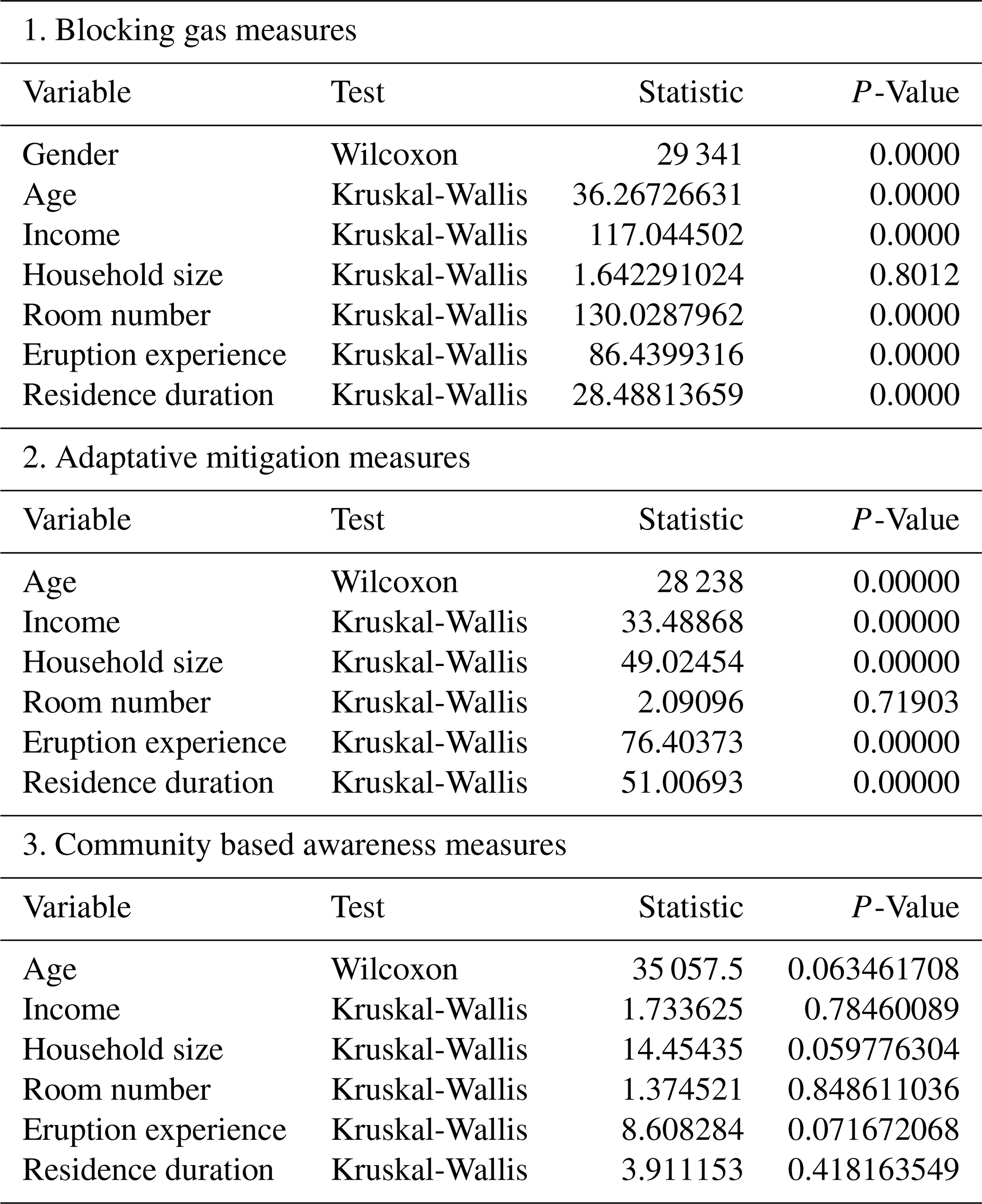
Only the aggregated indicators for motivation to implement preventive mazuku emission measures and adaptive strategies showed statistically significant variation across demographic groups (Appendix A). No significant differences were found in overall motivation levels based on local awareness measures. Financial conditions – specifically household monthly income and the number of rooms in a dwelling – were positively associated with motivation to implement both types of measures (Fig. 8).
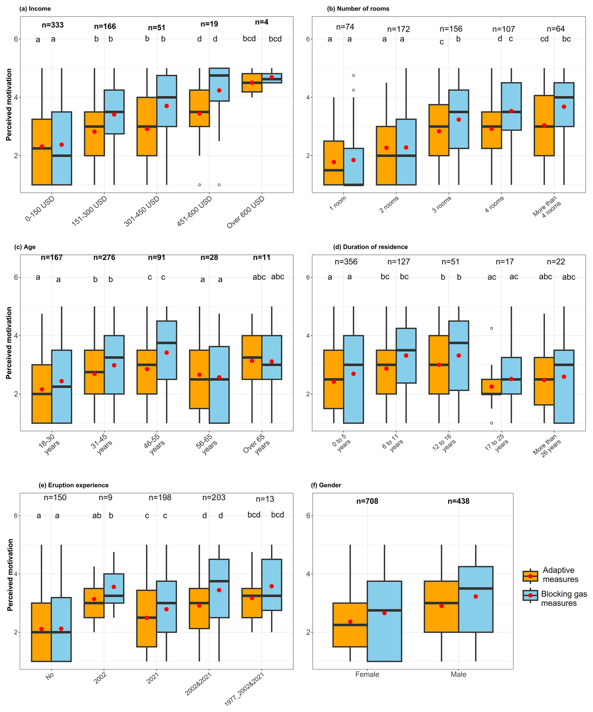
Figure 8The level of perceptions of the aggregated indicator according to significant determining factors. Perceptions are expressed on a numerical scale from 1 (very low) to 5 (very high). In each boxplot, the horizontal bold line represents the median, the red dot indicates the mean, and the small circles represent outliers. The letter on top on boxplots represents the post-hoc test results between groups of the same aggregate indicator not between the same group between two indicators.
Motivation levels for both preventive and adaptive measure increased with age and length of residence, but only up to a certain point. Beyond approximately 46 years of age, or after more than 17 years living in the area, motivation declined and then plateaued. Men exhibited higher motivation to implement these measures than women. Furthermore, individuals who had not previously experienced volcanic risk showed lower implementation willingness; however, their willingness increased with the number of personal experiences of Nyiragongo eruption risk.
4.4 Correlations
Pairwise Spearman's rank-order correlations indicate that perceived efficacy is a stronger driver of motivation than cost perceptions, although cost can either reinforce or hinder motivation depending on the type of measure. Figure 9A shows that most measures have a strong and statistically significant positive correlation between efficacy and motivation, particularly for measures such as blocking gas with waste materials or raising beds to adapt to gas emissions. This suggests that higher perceived effectiveness is consistently associated with a stronger willingness to implement these measures. However, there is no relationship between motivation and perceived efficacy for the measure of installing warning panels, which may be due to the fact that this intervention depends on disaster risk authorities rather than the community.
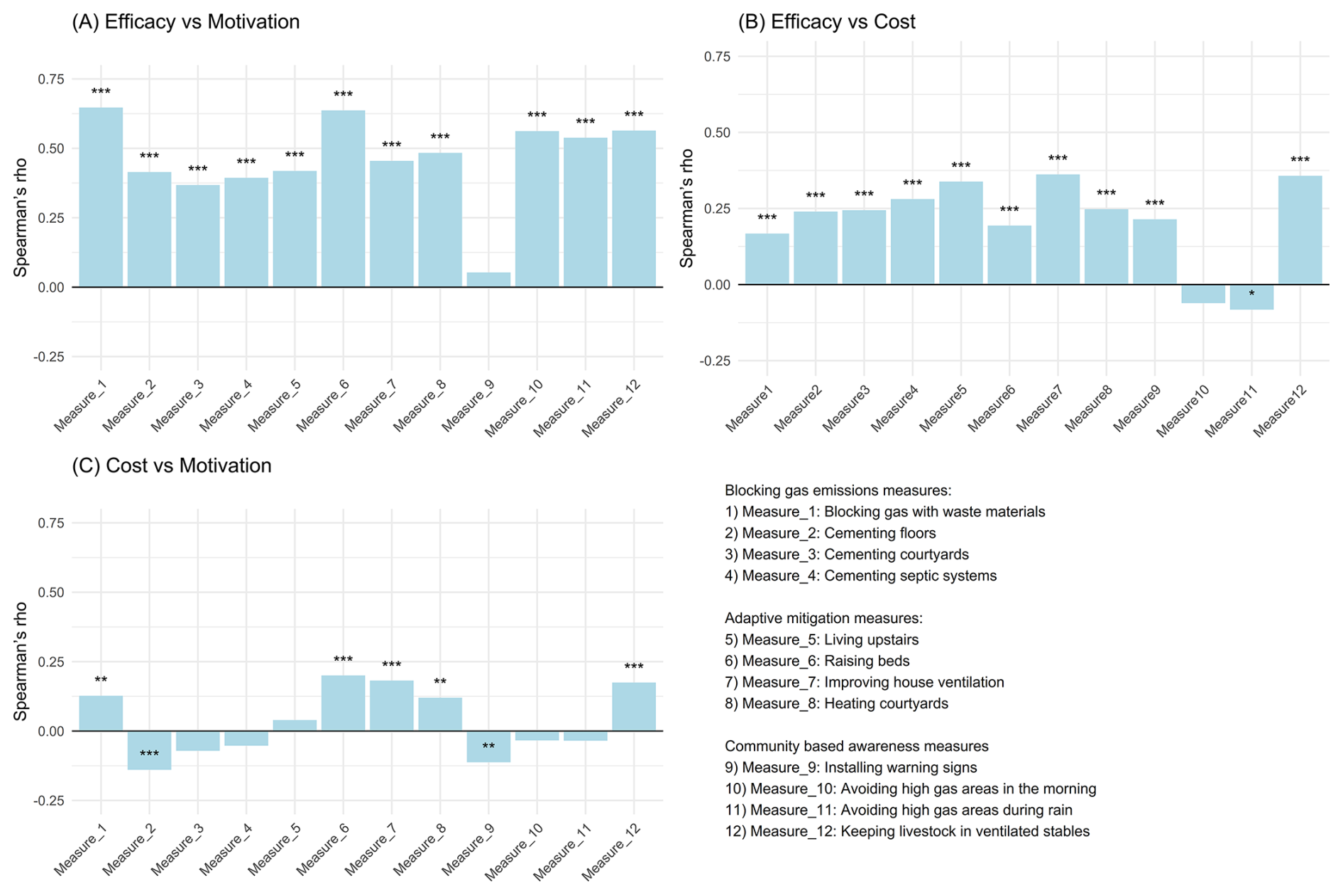
Figure 9Pairwise Spearman's rank-order correlations. p value < 0.001, p value < 0.01 and ∗ p value < 0.1.
Figure 9B also shows that there are mostly positive, though generally weak, relationships between perceived efficacy and cost. Notably, for the awareness measures of avoiding high gas areas in the early morning or after rainfall, there is no association between perceived efficacy and cost. Figure 9C reveals a more mixed pattern between cost and motivation: while certain adaptive and awareness measures (Measures 5, 6, 7, and 12) display a significant positive association, some blocking measures (e.g., Measure 2) are negatively correlated, indicating that higher perceived costs may discourage willingness to implement those interventions.
4.5 Spatial variation
Figure 10 presents the variation in the population's perceptions of efficacy across the sampling zones. It shows that aggregated efficacy is perceived very differently across the three sampling zones, with statistically significant differences. Zone 2 hosts a large proportion of the population who consider both awareness measures and those limiting mazuku emissions to be effective or even very effective. In contrast, zone 3 is home to the majority of people who regard emission-limiting or adaptation measures as ineffective. When grouping together those who perceive the measures as effective and those who consider them very effective, we find almost the same proportion of the population in Zone 3 regardless of the type of measure.
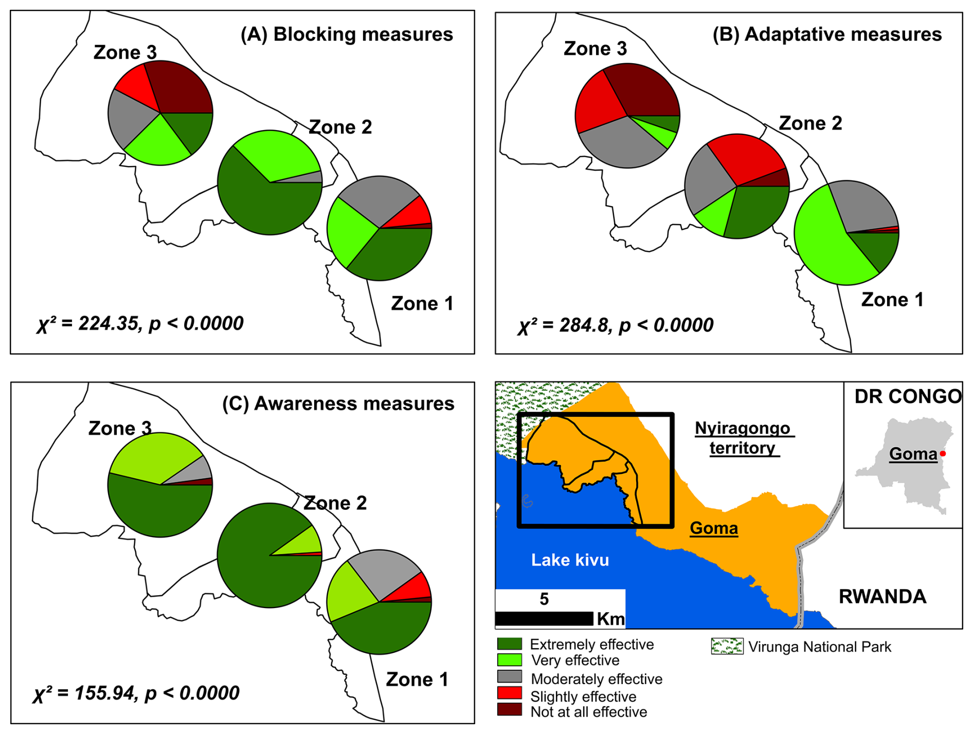
Figure 10Spatial variation of perceived efficacy across different sampling zones.
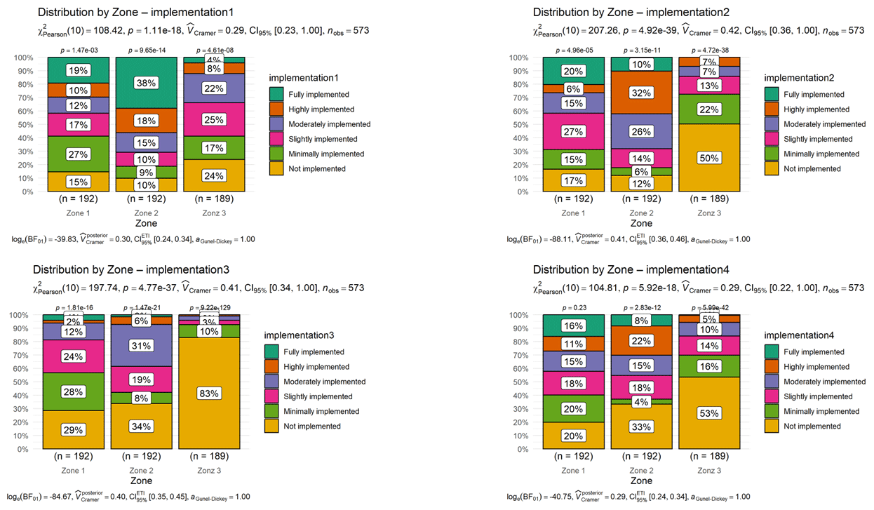
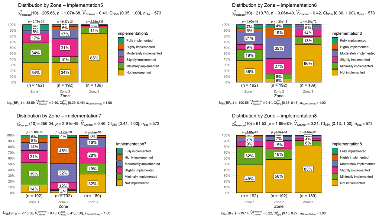
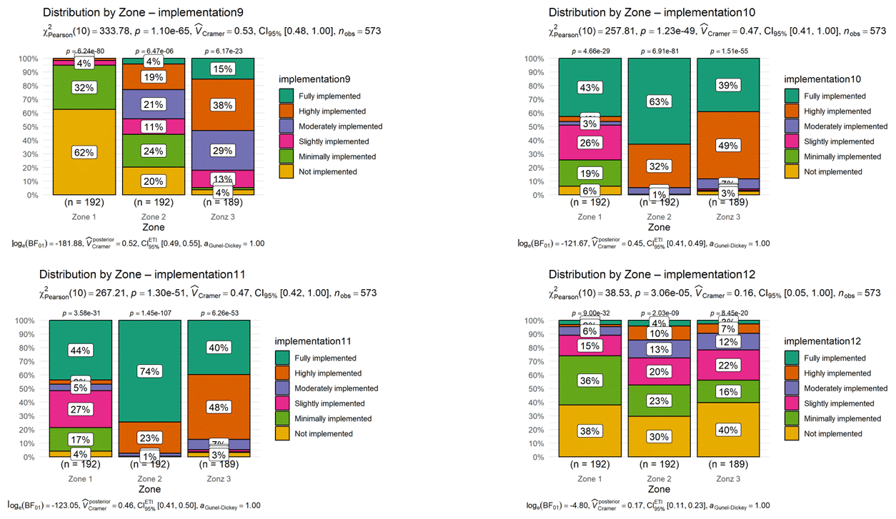
We also assessed the variation in the perceived level of implementation for each measure within each sampling zone (Appendix B). It is evident that measures requiring substantial resources, regardless of their category, are perceived as not implemented by a large proportion of the population in Zone 3 (over 65 % to 85 %). This is the case, for example, for heating or cementing courtyards, living on upper floors or raising bed heights. In contrast, for the measure involving the use of waste materials to limit mazuku emissions, only 24 % of the population in Zone 3 perceive it as not implemented. Awareness measures, such as identifying mazuku-prone areas for avoiding them during cold periods (in the morning or after rainfall), are the most widely perceived as implemented across all three zones, although the proportions of the population in their perception category vary by zone.
5.1 Passive Risk Acceptance: Motivation and Efficacy Constrained by Limited Living Options and resources scarcity
By 2019, one billion people were already living within 100 km of active volcanoes, with the density of human activities continuing to increase (Brown et al., 2015; Freire et al., 2019). In CO2 diffused degassing zones not restricted as parks or reserves (Williams-Jones and Rymer, 2015), people may choose to reside in areas with CO2 high-concentrations (Edmonds et al., 2017; Hansell and Oppenheimer, 2004), as in the present case study. This may reflect a risk acceptance. However, our findings indicate a more specific form of passive risk acceptance (Wachinger et al., 2013, 2018). Indeed, people are well aware of the risk posed by mazuku and claim to know where they are located, yet many still choose to live close to, or even on them. This could suggest that they have no other options left. Indeed, in Goma – a city already extremely densely populated (Pech et al., 2018; Pech and Lakes, 2017) – people often settle in these risky areas because, despite the volcanic hazards, Goma is perceived as safer than the conflict-affected surrounding regions (Mafuko Nyandwi et al., 2023a, b). Therefore, people have developed local mitigation measures to compensate for the insufficiency of the official advice to simply avoiding the area, as indicated on warning panels.
Wachinger et al. (2013) describe this as the risk-mitigation paradox – a situation in which people consciously choose to live exposed to hazards, and the choices of mitigation measures being controlled by resource availability. In such contexts, most participants report being motivated to identify high-concentration areas in order to avoid them during critical times, such as early mornings or after rainfall, when mazuku concentration is high. Being less resource-intensive, awareness-based measures were widely considered effective by the majority, particularly among low-income households, who also felt these measures had been largely implemented. Therefore, mazuku are perceived as a daily threat that can be controlled – through preventive measures, awareness of high-risk zones and times of day, or by adapting the environment (for example improved ventilation) to reduce its magnitude. It suggests that living in a zone prone to mazuku gives rise to a widespread, yet often unrecognised, acceptance of risk. Inhabitants develop everyday routines and coping practices in response to repeated exposure (Walshe et al., 2023), and over time these behaviours become internalised and incorporated into the community's habitus – defined by Bourdieu (1990) as the set of structured dispositions through which individuals perceive the hazardous environment and act in it. In effect, what begins as a mitigation strategy gradually solidifies into a socialised readiness to `live with' the hazard rather than to challenge or transform it (Vergara-Pinto and Marín, 2023; Walshe et al., 2023). This suggests that mazuku becomes embedded in the routines of everyday life, gradually normalised, and that the mitigation practices sustaining a perceived sense of “safe exposure” are reproduced through habit rather than being critically questioned or scrutinised.
However, Paton (2008) caution that if people overestimate the effectiveness of some mitigation measures or their ability to respond to a hazard, they may be less inclined to recognise the need for additional mitigation measures and less receptive to new awareness-raising initiatives. This is evident here: residents are less motivated to comply with mazuku warning panels at all times of a day because they believe they already know the “critical periods” (early mornings and after rainfall). Yet, in this region, it has been demonstrated that concentration levels can change suddenly following abrupt magmatic activities or volcanic events or due to diurnal–nocturnal fluctuations (Balagizi et al., 2018; Kasereka et al., 2017; Smets et al., 2010). Therefore, locally contextualised awareness initiatives that build upon people's risk experiences, knowledge, and available resources may prove more effective (Lutete Landu et al., 2023; Mafuko-Nyandwi et al., 2024).
5.2 The Influence of Risk Experience on Mazuku Mitigation
The literature indicates that risk experience influences the perceptions of people living in hazard-prone areas, whether in terms of risk perception or views on the implementation of mitigation measures (Mafuko Nyandwi et al., 2023a; Sattler et al., 2000; Townshend et al., 2015). In this perspective, our results show that the number of times an individual has experienced the risk of a volcanic eruption positively influences both the motivation to implement, and the perceived effectiveness of local mazuku mitigation measures. Moreover, there is evidence of spatial variation in perceptions of efficacy of mitigation measures, despite no comprehensive knowledge of how mazuku concentrations vary across different zones. Instead, variation in perception aligns more closely with historical patterns of land occupation and settlements.
This suggests that these patterns are more reflective of community-level perceptions and shared risk experiences than of an objective individual evaluation of risk mitigation (Becker et al., 2017). Before, the 2021 Nyiragongo eruption, we have observed already a spatial homogenisation in people's perception of volcanic risk across different neighbourhoods of Goma between old residents and newcomers (Mafuko Nyandwi et al., 2023a). This was partly because a long time had passed since the last eruption, and partly because Nyiragongo is an “open volcano” with a persistent reddish gas plume at its summit (Barrière et al., 2022), serving over the years as a continual reminder of the volcanic threat. Meanwhile, the mazuku hazard is silent, permanent, colourless and odourless (Smets et al., 2010). Thus, spatial homogeneity in how people perceive the implementation of mazuku mitigation measures appears to depend heavily on demographic factors, especially monthly income, which segregate populations into different settlement zones. Interviews in the affected area have already revealed three distinct settlement zones: high-income zone, transitional zone with middle-income households, and low-income household zone with high proportion of IDPs.
The spatial homogenisation of risk perception is had been also documented in others context. In an editorial review, Gaillard and Dibben (2008) demonstrated that the spatial dimension of risk perception is closely linked to the memory of past events or previous experiences of fatalities in a given area. This collective memory can shape entire communities residing in hazardous areas, fostering a strong attachment to their environment – as observed among populations in the Southern Andes that have experienced seven eruptions in less than a century (Vergara-Pinto and Marín, 2023; Walshe et al., 2023). This means that it is not individual experience that matters most, but rather the shared history of a community, in which the impacts of past fatalities remain visible (such as the skeletons of animals asphyxiated by mazuku) or are passed down orally from generation to generation, or from long-term residents to newcomers, or even from a neighbour to another one (Gaillard and Dibben, 2008). Moreover, within the same zone, households tend to implement only those measures that are affordable for them. This is the case with cementing house yards or septic pits, which are widely perceived implemented in zone 1, where high-income households live. Thus, the effective implementation of mitigation measures requires empowering local communities through a co-creation approach.
5.3 The Need for Co-Creation with Local Communities and Empowering Them
In a systematic review, Viveiros and Silva (2024) discuss both the environmental and health impacts of volcanic gases and highlight that mitigation strategies vary significantly between volcanic regions. In our study, we also identified mitigation measures that are specific to the Goma context, such as heating fires in courtyards to foster the dispersion of mazuku or using waste materials to block its emission. This highlights the importance of co-creating knowledge and mitigation measures with local communities (Pardo et al., 2015), rather than importing solutions that may not be suited to the local context (Bird et al., 2011). Therefore, understanding the incentives that drive these communities to mitigate mazuku-related risks is essential for effective risk management (Barclay et al., 2008, 2015).
In this perspective, our findings support Barclay et al. (2008), who noted that in many cases the risk is well known to the exposed population, yet they may fail to act due to competing life pressures such as resource constraints, rather than a lack of knowledge. We observed that both the perceived efficacy of risk mitigation measures and their perceived level of implementation vary across zones not because of differences in mazuku concentrations but because of resource limitations. People report being motivated to adopt a mitigation measure if they perceive it as effective and if it is affordable. In other words, even when a measure could be effective – such as cementing courtyards or septic pits – motivation to implement it declines sharply if resources are lacking and, paradoxically, our results indicate that the measure is then judged less effective. Therefore, mitigation measures that align with capacity of specific social groups are likely to be more effective than collective, one-size-fits-all solutions, like the installation of warning panels that are now the only official mitigation measures implemented in Goma. Achieving this requires researchers, decision-makers, and all other stakeholders involved in risk management to learn from local communities practices and collaborate with them in designing mitigation strategies that are locally contextualised.
This study did not assess the actual physical effectiveness of the 12 risk mitigation measures. Furthermore, data collection did not evaluate whether households had already been directly affected by Mazuku, given that the main impact – loss of human life – could raise ethical sensitivities. In addition, we did not assess whether households had individually implemented a given measure but rather enquired about the level of implementation within the neighbourhood as a whole. This approach was taken because, as highlighted during the interviews, the implementation of such measures was considered more as a collective matter at community level, since the sources of CO2 emissions were dispersed across different locations.
This study employed a mixed-methods approach, combining qualitative and quantitative techniques, to assess perceptions of the implementation of risk mitigation measures related to emissions of magmatic dry gases – primarily carbon dioxide – locally known in the study area as mazuku. Research of this kind is essential, given that the number of people living in active volcanic zones has continued to rise over the centuries, and that cases of human fatalities and livestock asphyxiation are regularly recorded in such areas.
The study identified three categories of risk mitigation measures implemented in the western part of Goma, within the Virunga volcanic province: (1) measures aimed at limiting mazuku emissions; (2) adaptive measures to reduce exposure to mazuku; and (3) awareness-related measures based on local knowledge, transmitted orally from generation to generation or from long-term residents to newcomers. Financial resources, along with risk experience – often linked to length of residence – were found to positively influence both motivation and the perceived effectiveness of the first two categories of measures. Perceptions of awareness-related measures showed no significant variations. Moreover, the study highlights spatial variation in both the level of implementation and the perceived effectiveness of these measures, not necessarily based on individual evaluation but rather on community-level knowledge of the local environment.
This study offers novel insights into the implementation of risk mitigation practices addressing volcanic gas emissions in active volcanic zones – such as heating courtyards or blocking gas with household waste – examined through a Global South perspective characterised by rapid and largely uncontrolled urbanisation. It reinforces the call, made by other scholars, for the co-creation of mitigation strategies with local communities, rather than the imposition of externally derived solutions that may not be effective in the local context. Future research could complement these findings by assessing the actual effectiveness of such mitigation measures through physical measurements of mazuku concentrations – not only in public spaces but also within buildings – and by further examining local risk perception. Moreover, volcano monitoring programmes in Goma and the surrounding areas should diversify their focus to include systematic monitoring of mazuku and recognise it as a significant public risk requiring sustained attention.
Table A1Results of test of variations of motivations according to demographic characteristics.
Raw and processed data are available on Zenodo (https://doi.org/10.5281/zenodo.17628103, Mafuko Nyandwi, 2025). Research design and the French questionnaire are available upon request from the corresponding author.
The author has declared that there are no competing interests.
The survey questionnaire and protocol were approved by the academic office of the University of Goma and local authorities at the municipality and neighbourhood levels in Goma. Verbal informed consent was obtained from the survey participants for their anonymized information to be published in this article.
The views expressed in this article are not necessarily those of GDN or AFD.
Publisher's note: Copernicus Publications remains neutral with regard to jurisdictional claims made in the text, published maps, institutional affiliations, or any other geographical representation in this paper. The authors bear the ultimate responsibility for providing appropriate place names. Views expressed in the text are those of the authors and do not necessarily reflect the views of the publisher.
The author gratefully acknowledges the invaluable work of the enumerators who collected the field data for this study, as well as the dedicated support of the University of Goma team involved in the GDN project.
This research has been supported by the Global Development Network (UNIGOM and Agence Française de Développement).
This paper was edited by Amy Donovan and reviewed by Francisca Vergara-Pinto and one anonymous referee.
Adalbert, S. M., François, K., Moritz, L., Eléonore, W., and Caroline, M.: Spatio-temporal location of population: Strengthening the capacities of sudden hazards risk management in Goma, DRC, International Journal of Disaster Risk Reduction, 66, https://doi.org/10.1016/j.ijdrr.2021.102565, 2021.
Balagizi, C. M., Kies, A., Kasereka, M. M., Tedesco, D., Yalire, M. M., and McCausland, W. A.: Natural hazards in Goma and the surrounding villages, East African Rift System, Natural Hazards, 93, 31–66, https://doi.org/10.1007/s11069-018-3288-x, 2018.
Barclay, J., Haynes, K., Mitchell, T., Solana, C., Teeuw, R., Darnell, A., Crosweller, H. S., Cole, P., Pyle, D., Lowe, C., Fearnley, C., and Kelman, I.: Framing volcanic risk communication within disaster risk reduction: Finding ways for the social and physical sciences to work together, Geol. Soc. Spec. Publ., 305, 163–177, https://doi.org/10.1144/SP305.14, 2008.
Barclay, J., Haynes, K., Houghton, B., and Johnston, D.: Social Processes and Volcanic Risk Reduction, 2nd edn., 1203–1214, https://doi.org/10.1016/b978-0-12-385938-9.00069-9, 2015.
Barrière, J., d'Oreye, N., Smets, B., Oth, A., Delhaye, L., Subira, J., Mashagiro, N., Derauw, D., Smittarello, D., and Syavulisembo, A. M.: Intra-crater eruption dynamics at Nyiragongo (DR Congo), 2002–2021, J. Geophys. Res. Solid Earth, 127, e2021JB023858, https://doi.org/10.1029/2021JB023858, 2022.
Becker, J. S., Paton, D., Johnston, D. M., Ronan, K. R., and Mcclure, J.: The role of prior experience in informing and motivating earthquake preparedness, International Journal of Disaster Risk Reduction, 22, 179–193, https://doi.org/10.1016/j.ijdrr.2017.03.006, 2017.
Bird, D. K., Gísladóttir, G., and Dominey-Howes, D.: Different communities, different perspectives: Issues affecting residents' response to a volcanic eruption in southern Iceland, Bull. Volcanol., 73, 1209–1227, https://doi.org/10.1007/s00445-011-0464-1, 2011.
Bourdieu, P.: The logic of practice, Stanford university press, https://doi.org/10.1515/9781503621749, 1990.
Brown, S. K. and Jenkins, S. F.: Global distribution of volcanic threat, Global Volcanic Hazards and Risk, 359–369, https://doi.org/10.1186/s13617-017-0067-4, 2017.
Brown, S. K., Auker, M. R., and Sparks, R. S. J.: Populations around holocene volcanoes and development of a population exposure index, Global Volcanic Hazards and Risk, 223–232, https://doi.org/10.1017/CBO9781316276273.006, 2015.
Büscher, K. and Vlassenroot, K.: Humanitarian presence and urban development: New opportunities and contrasts in Goma, DRC, Disasters, 34, 256–273, https://doi.org/10.1111/j.1467-7717.2010.01157.x, 2010.
Edmonds, M., Grattan, J., and Michnowicz, S.: Volcanic gases: silent killers, in: Observing the volcano world: volcano crisis communication, Springer, 65–83, https://doi.org/10.1007/11157_2015_14, 2017.
Freire, S., Florczyk, A. J., Pesaresi, M., and Sliuzas, R.: An improved global analysis of population distribution in proximity to active volcanoes, 1975–2015, ISPRS Int. J. Geoinf., 8, 341, https://doi.org/10.3390/ijgi8080341, 2019.
Gaillard, J. C. and Dibben, C. J. L.: Volcanic risk perception and beyond, Journal of Volcanology and Geothermal Research, 172, 163–169, https://doi.org/10.1016/j.jvolgeores.2007.12.015, 2008.
Geirsson, H., d'Oreye, N., Mashagiro, N., Syauswa, M., Celli, G., Kadufu, B., Smets, B., and Kervyn, F.: Volcano-tectonic deformation in the Kivu Region, Central Africa: Results from six years of continuous GNSS observations of the Kivu Geodetic Network (KivuGNet), Journal of African Earth Sciences, 134, 809–823, https://doi.org/10.1016/j.jafrearsci.2016.12.013, 2017.
Hansell, A. and Oppenheimer, C.: Health Hazards from Volcanic Gases: A Systematic Literature Review, Arch. Environ. Health, 59, 628–639, https://doi.org/10.1080/00039890409602947, 2004.
Hirslund, F. and Morkel, P.: Managing the dangers in Lake Kivu – How and why, Journal of African Earth Sciences, 161, 103672, https://doi.org/10.1016/j.jafrearsci.2019.103672, 2020.
Kasereka, M. M., Yalire, M. M., Minani, A. S., Samba, C. V, Bisusa, A. K., and Kamate, E. K.: Les risques lies aux mazuku dans la région de Goma, République démocratique du Congo (rift est-africain), Journal of Water Environnement Sciences, 1, 164–174, 2017.
Kervyn, M., Barette, F., Poppe, S., Smets, B., Syavulisembo Muhindo, A., Kambale Makundi, J., Ngunzi Kahashi, Y., Kambale Ndagana, J., Mossoux, S., Kervyn, F., and Michellier, C.: Assessing lava flow susceptibility at neighbouring volcanoes: Nyamulagira and Nyiragongo volcanoes, Virunga Volcanic Province, Journal of Applied Volcanology, 13, 5, https://doi.org/10.1186/s13617-024-00143-y, 2024.
Loughlin, S. C., Vye-Brown, C., Sparks, R. S. J., Brown, S. K., Barclay, J., Calder, E., Cottrell, E., Jolly, G., Komorowski, J. C., Mandeville, C., Newhall, C., Palma, J., Potter, S., and Valentine, G.: An introduction to global volcanic hazard and risk, 1–79, https://doi.org/10.1017/CBO9781316276273.003, 2015.
Lutete Landu, E., Ilombe Mawe, G., Makanzu Imwangana, F., Bielders, C., Dewitte, O., Poesen, J., Hubert, A., and Vanmaercke, M.: Effectiveness of measures aiming to stabilize urban gullies in tropical cities: Results from field surveys across D.R. Congo, International Soil and Water Conservation Research, 11, 14–29, https://doi.org/10.1016/j.iswcr.2022.10.003, 2023.
Mafuko Nyandwi, B.: Data on perception of the implementation and effectiveness of local dry-gas degassing measures in the Goma area (East DRC), Zenodo [data set], https://doi.org/10.5281/zenodo.17628103, 2025.
Mafuko Nyandwi, B., Kervyn, M., Habiyaremye, F. M., Kervyn, F., and Michellier, C.: Differences in volcanic risk perception among Goma's population before the Nyiragongo eruption of May 2021, Virunga volcanic province (DR Congo), Nat. Hazards Earth Syst. Sci., 23, 933–953, https://doi.org/10.5194/nhess-23-933-2023, 2023a.
Mafuko Nyandwi, B., Kervyn, M., Muhashy Habiyaremye, F., Kervyn, F., and Michellier, C.: To go or not to go when the lava flow is coming? Understanding evacuation decisions of Goma inhabitants during the 2021 Nyiragongo eruption crisis, Journal of Volcanology and Geothermal Research, https://doi.org/10.1016/j.jvolgeores.2023.107947, 2023b.
Mafuko-Nyandwi, B., Kervyn, M., Habiyaremye, F. M., Vanwing, T., Kervyn, F., Jacquet, W., Mitengezo, V., and Michellier, C.: Building a prepared community to volcanic risk in the global south: Assessment of awareness raising tools for high school students in Goma, (East DR Congo), Progress in Disaster Science, 24, 100370, https://doi.org/10.1016/j.pdisas.2024.100370, 2024.
Morgan, K.: Sample size determination using Krejcie and Morgan table, Kenya Projects Organization (KENPRO), 38, 607–610, https://doi.org/10.13140/RG.2.2.11445.19687, 1970.
Pardo, N., Wilson, H., Procter, J. N., Lattughi, E., and Black, T.: Bridging Māori indigenous knowledge and western geosciences to reduce social vulnerability in active volcanic regions, Journal of Applied Volcanology, 4, 5, https://doi.org/10.1186/s13617-014-0019-1, 2015.
Paton, D.: Risk communication and natural hazard mitigation: How trust influences its effectiveness, International Journal of Global Environmental Issues, 8, 2–16, https://doi.org/10.1504/IJGENVI.2008.017256, 2008.
Pech, L. and Lakes, T.: The impact of armed conflict and forced migration on urban expansion in Goma: Introduction to a simple method of satellite-imagery analysis as a complement to field research, Applied Geography, 88, 161–173, https://doi.org/10.1016/j.apgeog.2017.07.008, 2017.
Pech, L., Büscher, K., and Lakes, T.: Intraurban development in a city under protracted armed conflict: Patterns and actors in Goma, DR Congo, Polit. Geogr., 66, 98–112, https://doi.org/10.1016/j.polgeo.2018.08.006, 2018.
Quesada-Román, A.: Disaster risk assessment of informal settlements in the Global South, Sustainability, 14, 10261, https://doi.org/10.3390/su141610261, 2022.
Sattler, D. N., Kaiser, C. F., and Hittner, J. B.: Disaster preparedness: Relationships among prior experience, personal characteristics, and distress, J. Appl. Soc. Psychol., 30, 1396–1420, https://doi.org/10.1111/j.1559-1816.2000.tb02527.x, 2000.
Smets, B.: Dynamics of volcanic activity in a youthful extensional setting studied by means of remote sensing and ground-based monitoring techniques - Nyiragongo and Nyamulagira volcanoes – (North Kivu, D.R. Congo), Vrije Universiteit Brussel, 254 pp., https://hdl.handle.net/20.500.14017/66f1ea93-0fc2-4423-81db-d7574f3785ca (last access: 4 March 2026), 2016.
Smets, B., Tedesco, D., Kervyn, F., Kies, A., Vaselli, O., and Yalire, M. M.: Dry gas vents (“mazuku”) in Goma region (North-Kivu, Democratic Republic of Congo): Formation and risk assessment, Journal of African Earth Sciences, 58, 787–798, https://doi.org/10.1016/j.jafrearsci.2010.04.008, 2010.
Smets, B., d'Oreye, N., Kervyn, M., and Kervyn, F.: Gas piston activity of the Nyiragongo lava lake: First insights from a Stereographic Time-Lapse Camera system, Journal of African Earth Sciences, 134, 874–887, https://doi.org/10.1016/j.jafrearsci.2016.04.010, 2017.
Smittarello, D., Barrière, J., d'Oreye, N., Smets, B., Oth, A., Shreve, T., Subira, J., Nyandwi, B. M., Cayol, V., and Grandin, R.: Propagation and arrest of the May 2021 lateral dike intrusion at Nyiragongo (DR Congo), Authorea Preprints, https://doi.org/10.1002/essoar.10509249.1, 2022.
Subira Muhindo, J.: Seismicity and Seismological Models of the Virunga Volcanic Province and Kivu Rift, Democratic Republic of Congo, https://hdl.handle.net/2268/321401 (last access: 4 March 2026), 2024.
Townshend, I., Awosoga, O., Kulig, J., and Fan, H. Y.: Social cohesion and resilience across communities that have experienced a disaster, Natural Hazards, 76, 913–938, https://doi.org/10.1007/s11069-014-1526-4, 2015.
Vaselli, O., Capaccioni, B., Tedesco, D., Tassi, F., and Yalire, M.: The “evil winds” (mazukus) at Nyiragongo Volcano (Democratic Republic of Congo), Acta vulcanologica, Journal of the National Volcanic Group of Italy, 14–15, 123–128, 2003.
Vergara-Pinto, F. and Marín, A.: Stratigraphy of volcanic memory: Sociocultural dimensions of volcanic risk in the Southern Andes, Chile, Journal of Contingencies and Crisis Management, 31, 1018–1033, https://doi.org/10.1111/1468-5973.12474, 2023.
Viveiros, F. and Silva, C.: Hazardous volcanic CO2 diffuse degassing areas – A systematic review on environmental impacts, health, and mitigation strategies, iScience, 27, https://doi.org/10.1016/j.isci.2024.110990, 2024.
Viveiros, F., Gaspar, J. L., Ferreira, T., and Silva, C.: Hazardous indoor CO2 concentrations in volcanic environments, Environmental Pollution, 214, 776–786, 2016.
Vlassenroot, K. and Büscher, K.: The City as Frontier: Urban Development and Identity Processes in Goma, Crisis, 1797, 1–7, 2009.
Vlassenroot, K. and Büscher, K.: The border city of Goma: zone of contestation or laboratory of change?, Poverty in medium and small cities of developing countries, 161–178, https://researchonline.lse.ac.uk/id/eprint/28479 (last access: 4 March 2026), 2011.
Wachinger, G., Renn, O., Begg, C., and Kuhlicke, C.: The Risk Perception Paradox – Implications for Governance and Communication of Natural Hazards, Risk analysis, 33, https://doi.org/10.1111/j.1539-6924.2012.01942.x, 2013.
Wachinger, G., Keilholz, P., and O'Brian, C.: The Difficult Path from Perception to Precautionary Action – Participatory Modeling as a Practical Tool to Overcome the Risk Perception Paradox in Flood Preparedness, International Journal of Disaster Risk Science, 9, 472–485, https://doi.org/10.1007/s13753-018-0203-8, 2018.
Walshe, R., Morin, J., Donovan, A., Vergara-Pinto, F., and Smith, C.: Contrasting memories and imaginaries of Lonquimay volcano, Chile, International Journal of Disaster Risk Reduction, 97, 104003, https://doi.org/10.1016/j.ijdrr.2023.104003, 2023.
Wauthier, C., Smets, B., Hooper, A., Kervyn, F., and D'Oreye, N.: Identification of subsiding areas undergoing significant magmatic carbon dioxide degassing, along the northern shore of Lake Kivu, East African Rift, Journal of Volcanology and Geothermal Research, 363, 40–49, https://doi.org/10.1016/j.jvolgeores.2018.08.018, 2018.
Williams-Jones, G. and Rymer, H.: Hazards of volcanic gases, in: The encyclopedia of volcanoes, Elsevier, 985–992, https://doi.org/10.1016/B978-0-12-385938-9.00057-2, 2015.
- Abstract
- Introduction
- Goma region: socio-environmental setting and mazuku formation
- Methodology
- Results
- Discussions
- Limitations
- Conclusion
- Appendix A
- Appendix B: The spatial variations of level of implementation per sampling zones
- Data availability
- Competing interests
- Ethical statement
- Disclaimer
- Acknowledgements
- Financial support
- Review statement
- References