the Creative Commons Attribution 4.0 License.
the Creative Commons Attribution 4.0 License.
 | 26 Sep 2025
Hillslope torrential hazard cascades in tropical mountains
Maria Isabel Arango-Carmona
Paul Voit
Marcel Hürlimann
Edier Aristizábal
Oliver Korup
Torrential hazards refer to the spectrum of water–sediment flows that include debris flows, debris floods, hyperconcentrated flows, and flash floods. These processes often occur in cascading sequences with landslides and have been particularly highly destructive in tropical and humid subtropical mountains. We compiled a database of 22 cascade events from 2009 to 2024 and analysed their topography, their sediment type, and the intensity and extremity of both antecedent and triggering rainfall to identify common traits. The results showed that only a few cases were linked to the most extreme rainfall recorded, suggesting that other controls, such as sediment availability, may be needed for initiating hazard cascades. Clustering analysis revealed that regions with steeper slopes and finer soils experienced cascades even under lower-intensity rainfall, whereas gentler slopes with coarser material required more extreme triggering rainfall. Cases including both earthquakes and rainfall showed that these triggers can interact across time, such as a rainy season preceding an earthquake or vice versa, or even simultaneously, highlighting the susceptibility of tectonically active tropical regions. Our findings highlight the need to prioritize hazard assessment in tropical mountains and may support the work of researchers and disaster risk agencies in terms of early warning and land use planning in underreported regions like Africa.
- Article
(13590 KB) - Full-text XML
- BibTeX
- EndNote


On 16 December 1999, intense rainfall followed an extraordinarily wet month and triggered shallow landslides and hillslope debris flows across 24 catchments in the mountainous northern Vargas state, Venezuela (García-Martínez and López, 2005). These flows coalesced with flash floods and hyperconcentrated flows and evolved into channelized debris flows that surged downstream through steep, narrow canyons, ultimately reaching the urbanized alluvial fans at high speeds. These highly destructive flows carried boulders up to 10 m in diameter (Larsen et al., 2001), and the sudden onset of the event left many residents trapped in their homes. Within a single day, multiple pulses of debris flows struck urban areas, killing an estimated 15 000 people, though some estimates suggest the toll could have been as high as 50 000 (Stager, 2009). Over 23 000 houses were destroyed, and another 65 000 were damaged. This remains, to date, the deadliest disaster in Venezuela's history and one of the deadliest in Latin America (García-Martínez and López, 2005).
This disaster is one of the most prominent examples of a type of hazard cascade consisting of a sequence of physically linked processes between hillslope and channels involving mixtures of water and sediment. Reports of similarly destructive events have become more frequent in recent years, but despite this growing number of case studies, the literature hardly offers more systematic studies. According to EM-DAT, the world's largest disaster database (https://www.emdat.be/, last access: 1 August 2024), 8 out of the 10 most fatal disasters from 2000 until 2024 in the categories “flash floods, floods, mudslides, wet avalanches, landslides, and rockfalls” hint in their description at hazard cascades, but they are hard to spot given the lack of a consistent reporting protocol. Moreover, given the unsteady and non-uniform flow in many torrential and hillslope hazards, the distinction between processes and their geomorphic evidence is easily blurred, promoting misinterpretation or even confusion of the most dominant or destructive process. Entries in disaster databases hardly separate single landslides or debris flows from hazard cascades, instead listing only the process thought to be the most damaging (Cabral et al., 2023; Dowling and Santi, 2014). For example, Legiman et al. (2023) studied 26 debris flow events from 1995 to 2022 in Malaysia, noting that at least 5 involved combinations of debris flows, debris floods, and mudflows. Kanji et al. (2003) examined 15 debris flow events in Brazil between 1967 and 2000 and concluded that the most destructive were those fed by numerous and simultaneous landslides. Jaapar et al. (2023). compiled 15 debris flow events in Malaysia, many of them hazard cascades, which they called “cascading geological events”, and recognized them as a growing hazard.
Among the disasters recorded in EM-DAT under the categories mentioned before, 273 report more than 100 deaths, with 72 % occurring in the tropics. A global compilation of fatal debris flows that occurred in 2019 highlighted the two most destructive events as part of hazard cascades (Prakash et al., 2024), both occurring in tropical regions, i.e. one triggered by Tropical Cyclone Idai in Chimanimani, Zimbabwe, claiming 344 deaths, and one triggered by monsoon rainfall in Kerala, India, killing 120 people. Other countries affected by major debris flow disasters that year include Zimbabwe, Indonesia, Brazil, India, and China (Prakash et al., 2024).
The tropics cover about one-third of the terrestrial land surface, and their environmental conditions, including high sediment availability, frequent earthquakes, and intense seasonal rainfall events, create optimal conditions for cascading hazards. These natural conditions overlap with the high vulnerability of tropical countries, in many of which low levels of economic development contrast with high levels of vulnerability (Sachs, 2001), offering limited options for hazard and risk management. A more comprehensive analysis of these hazard cascades in tropical mountains is essential to inform risk management and disaster response strategies. Early warning systems, mitigation measures, and land use regulations might strongly benefit from a better understanding of the conditions that lead to hazard cascades.
To address some of the previously mentioned shortcomings and contribute to the knowledge base of hazard cascades of coupled hillslope and torrential processes in the tropics, our goal is to estimate the relative roles of topography characteristics, soil granulometry, and sediment connectivity and the extremeness of antecedent and triggering rainfall. We begin in Sect. 2 with a review of current knowledge on hillslope torrential cascades, focusing particularly on the conditions that favour their occurrence in the tropics. We aim to classify these events based on topographic, granulometric, and rainfall-related variables to identify patterns and distinguish event types. Section 3 describes the methodology and data used for the classification analysis, with the findings presented in Sect. 4, further discussed in Sect. 5, and summarized in Sect. 6.
2.1 Hillslope torrential cascades
Torrential hazards (Fuchs et al., 2019; Schlögl et al., 2021), also known as catastrophic hydrogeomorphic events (Stoffel et al., 2013; Wilford et al., 2005), refer to processes that route mixtures of water and sediment down mountain channels. While intense rainfall is the most frequent trigger, other triggers include volcanic eruptions, earthquakes, and outburst floods caused by glacial, landslide, or human-made dams (Kaitna et al., 2024). Torrential hazards include debris flows, debris floods, hyperconcentrated flows, and flash floods, defined by differing sediment concentrations and flow mechanics (Borga et al., 2014; Iverson, 1997) (Table 1). Despite some measurable differences in sediment concentration, different stages during a single flow may show either hydraulic or rheological characteristics (Borga et al., 2014; Brenna et al., 2020; Costa, 1988; O'Brien and Julien, 1985). Hungr et al. (2014) use the term “debris flow” in a broad sense to encompass a cascading sequence of geomorphic processes that are initiated on hillslopes, such as shallow landslides and debris avalanches, and subsequently propagate along drainage channels as debris flows and floods. This integrated definition emphasizes the slope-to-channel sediment transfer and the coupling between hillslope and fluvial processes at the basin scale as a cascading system of sediment transfer in steep mountain catchments. This cascade is not limited to single events but involves a sequence of interactions, which reinforces the importance of analysing torrential hazards at the scale of the catchment system (Laigle and Bardou, 2022).
Hillslope torrential cascades (HTCs) are a sequence of interconnected processes that begin on hillslopes as landslides and transfer sediment through various torrential hazards, ranging from debris flows to stream water floods. More broadly, cascading hazards refer to the phenomenon where an initial event triggers a chain of subsequent processes, which may interact to generate new, potentially more destructive outcomes (Zhang et al., 2023). HTCs are mostly initiated by rainfall infiltrating and saturating the soil, reducing its shear strength and triggering shallow landslides (Church and Jakob, 2020; Gregoretti and Fontana, 2008; Hungr, 2005; Takahashi, 1981) (Fig. 1). Sometimes, these landslides are triggered as regional events, where up to tens of thousands of shallow landslides happen in the course of several hours over areas up to 20 000 km2. These events were labelled multiple-occurrence regional landslide events (MORLEs) by Crozier (2005). High pore pressure may cause liquefaction and allow the landslide mass to deform like a fluid, creating hillslope debris flows, which reach the channel network if mobile enough (Iverson, 1997; Johnson, 1984). The resulting flow can be a debris flow, debris flood, or hyperconcentrated flow, or it can alternate between them, for example when a channelized debris flow outpaces slower-moving flood waves of lesser sediment content, by bed erosion that causes flow bulking, by an increase in discharge and sediment deposition of the debris flow (Church and Jakob, 2020), by flow blockages caused by woody debris that briefly increase flow momentum, or by a mudflow entering the drainage network (Laigle and Bardou, 2022). Unlike MORLEs, where the deposits are mostly confined to steep slopes or channels without further interaction with fluvial processes (Fig. 2a and b), the sediment entrainment from debris flows into flooded channels allows HTCs to travel longer distances as heavily sediment-laden flows (Figs. 1 and 2d–g), until reaching torrential fans, i.e. cone-shaped sedimentary landforms at major breaks in slope, for example at mountain-range fronts. Torrential fans are often prime sites for residential development and infrastructure that take advantage of gentle gradients, access to water, and unconsolidated sediment as building materials (Stoffel et al., 2013).

Figure 1Example of torrential and hillslope processes and their linkages during HTCs. Orthographic view of the HTCs in West Pokot, Kenya, in 2020 (Event 15, Table A1). Coordinates of the central point: 1°16′26.17′′ N, 35°36′28.21′′ E. Source: Planet Team (2017).
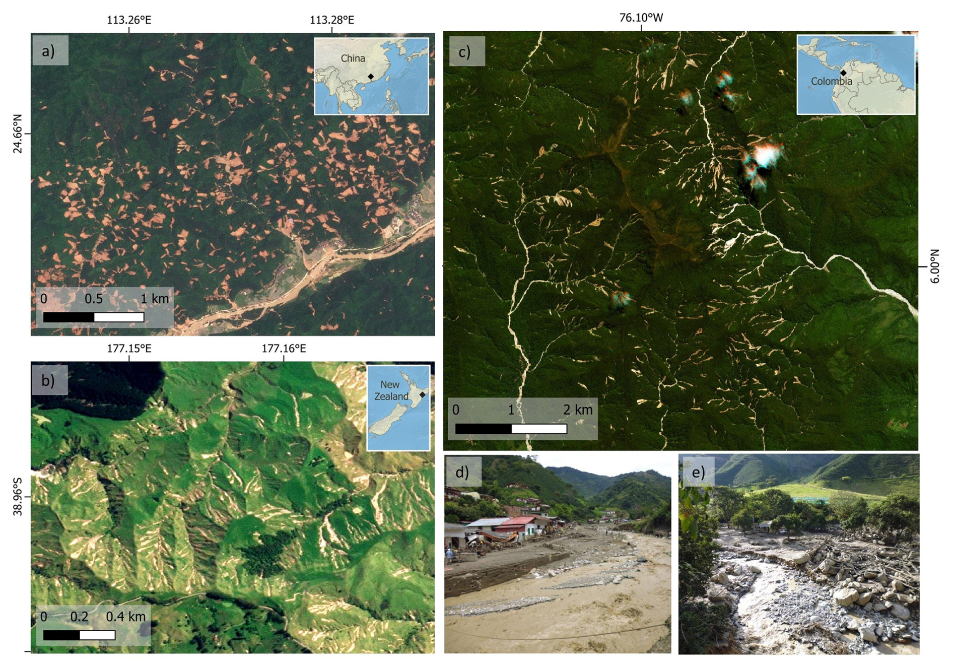
Figure 2Geomorphic evidence of multiple-occurrence regional landslide events (MORLEs), where sediment from landslides is deposited and retained in the lower slope areas, without being transported through channels: (a) Jiangwang, Guandong, China, in 2024 and (b) Wairoa, Aotearoa / New Zealand, in 2022. On the contrary, in HTCs, like the event in Salgar, Colombia, in 2015 (c) (Event 3 in Table A1), sediment entrainment in flooded channels generated rapid channelized debris flows and debris floods (d, e) that destroyed over 60 homes and killed 93 people downstream. Sources: (a–c) Planet Team (2017) and (d, e) images courtesy of Jafed Naranjo Guarín.
2.2 Conditioning and triggering factors of HTCs
Torrential processes depend on three key ingredients: steep slopes, sediment availability, and water (Rickenmann, 2016). The conditioning and triggering factors for individual torrential processes are well understood (Borga et al., 2014; Kaitna et al., 2024), but the controls that promote their coupling with each other and with slope processes, as well as their transformation into a cascade, are less clear. These controls likely include the magnitude and duration of the triggering rainfall and the ratio of sediment and water to generate and maintain highly mobile flows. Also, positive feedbacks might amplify the effects of each process, causing the terrain to cater to both sediment and fluvial connectivity to support the process cascade. The following sections describe the three key conditioning and triggering factors of HTCs: rainfall, topography, and sediment availability and connectivity.
2.2.1 Rainfall
Intense rainstorms trigger HTCs by providing abundant water in a short period to saturate soils or exceed their infiltration capacity, causing excess surface runoff, landslides, and channel erosion. Intense rainfall episodes are created or enhanced by topography in three possible ways: (i) by promoting the vertical motion of air masses, causing condensation (Kaitna et al., 2024); (ii) by developing low-level clouds by the blockage of air masses that are fed by upper clouds and create a seeder–feeder mechanism (Fernández-González et al., 2015); and (iii) by the rapid rise of potentially unstable air masses above the level of free convection (Caracena et al., 1979; Galewsky et al., 2006).
Tropical rainfall is strongly influenced by the Intertropical Convergence Zone (ITCZ), which drives high-intensity rainfall events as part of monsoons and cyclones. The local convergence of air masses along monsoon shear lines, the presence of deep convection zones, and the interaction of factors like the Coriolis force, zonal thermal low-pressure troughs, and the Madden–Julian Oscillation (MJO) all contribute to intense rainstorms in the tropics (Callaghan and Bonell, 2005; Madden and Julian, 1971). Although highly variable, the frequency of high-intensity rainfall events (> 25 mm h−1) is greater in the tropics than in any other region of the world (Encalada et al., 2019), with convective and cyclonic storms significantly contributing to these extreme events (Syvitski et al., 2014).
Antecedent soil saturation and snowmelt can significantly increase terrain susceptibility to torrential hazards by enhancing the likelihood of failure (Prenner et al., 2019). When soils are already moist or saturated due to previous rainfall events, their capacity to absorb additional precipitation decreases markedly, increasing the probability of surface runoff and shallow landsliding. In tropical mountain regions, where precipitation can be both frequent and intense, short intervals between storms often do not allow sufficient time for soils to drain, leading to a cumulative saturation effect. This preconditioning plays a critical role in triggering hillslope failures during subsequent storms, even if rainfall intensities are moderate.
2.2.2 Topography
A common approach to distinguish catchments prone to torrential hazards relies on their morphometric characteristics. Basins that generate debris flows are generally steeper and smaller than those where debris floods or floods occur and have less developed channel networks that generate very high peak discharges upon intense rainfall (de Haas et al., 2024). Catchments dominated by debris flows have values of morphometric variables like catchment area, slope, and drainage length that lie between those dominated by fluvial floods and flash floods and those dominated by gravitational processes (Bertrand et al., 2013; Jackson et al., 1987; Melton, 1957; Welsh and Davies, 2011; Wilford et al., 2004). Yet, catchments may respond by different torrential processes to the same level of rainfall intensity (Borga et al., 2014; Wilford et al., 2004). Moreover, several studies indicate that morphometric characteristics or thresholds derived from higher latitudes may not be applicable to the tropics. For example, catchments prone to torrential hazards in tropical and temperate regions may differ in their Melton index, average fan slope, or debris flow travel distance (Arango-Carmona et al., 2021; Dias et al., 2022b; Lin and Jeng, 2000). Adapting such indices to differing environments is thus problematic because torrential hazards are likely conditioned and triggered by a combination of environmental, geologic, and climatic factors rather than by topographic features only (de Haas et al., 2024).
2.2.3 Sediment availability and connectivity
The availability and type of sediment determine how a mountainous area responds to heavy rainfall, and catchments can be classified as transport-limited or supply-limited (Bovis and Jakob, 1999). Transport-limited watersheds have high amounts of sediment and high recharge rates such that torrential events depend only on sufficient rainfall. Supply-limited watersheds are often bedrock-dominated and tend to have less frequent, but more extreme (i.e. with higher sediment volumes), torrential events compared to transport-limited basins (Bovis and Jakob, 1999; de Haas et al., 2024).
Sediment connectivity refers to the downstream mobility of loose materials within a catchment and estimates the potential for particles to move towards the catchment outlet (Hooke, 2003). A high sediment connectivity can enhance the connection between hillslopes and torrential processes. For example, during Hurricane Maria in Puerto Rico in 2017, Bessette-Kirton et al. (2020) found that coalescing landslides and those entering channels had increased mobility, likely due to sediment entrainment into floodwater and aggregation from various landslide sources. The study noted that even though most landslides were single, coalescing landslides and those entering channels made up most of the affected area. Controls on sediment connectivity include terrain morphology, barriers like stream blockages or dams, catchment shape, drainage density, slope, and surface roughness (Cavalli et al., 2013) and sediment shape, volume, and particle size and land cover (Bracken and Croke, 2007).
We followed a methodology comprising three steps to evaluate the influence of topographic characteristics, soil granulometry, and triggering rainfall in the initiation and propagation of HTCs. First, we compiled a database of documented HTCs, delineating their area of interest (AOI). Then we collected data on rainfall, topography, and sediment characteristics for each event in our database. Finally, we applied a clustering analysis to identify patterns and similarities among study regions based on such characteristics.
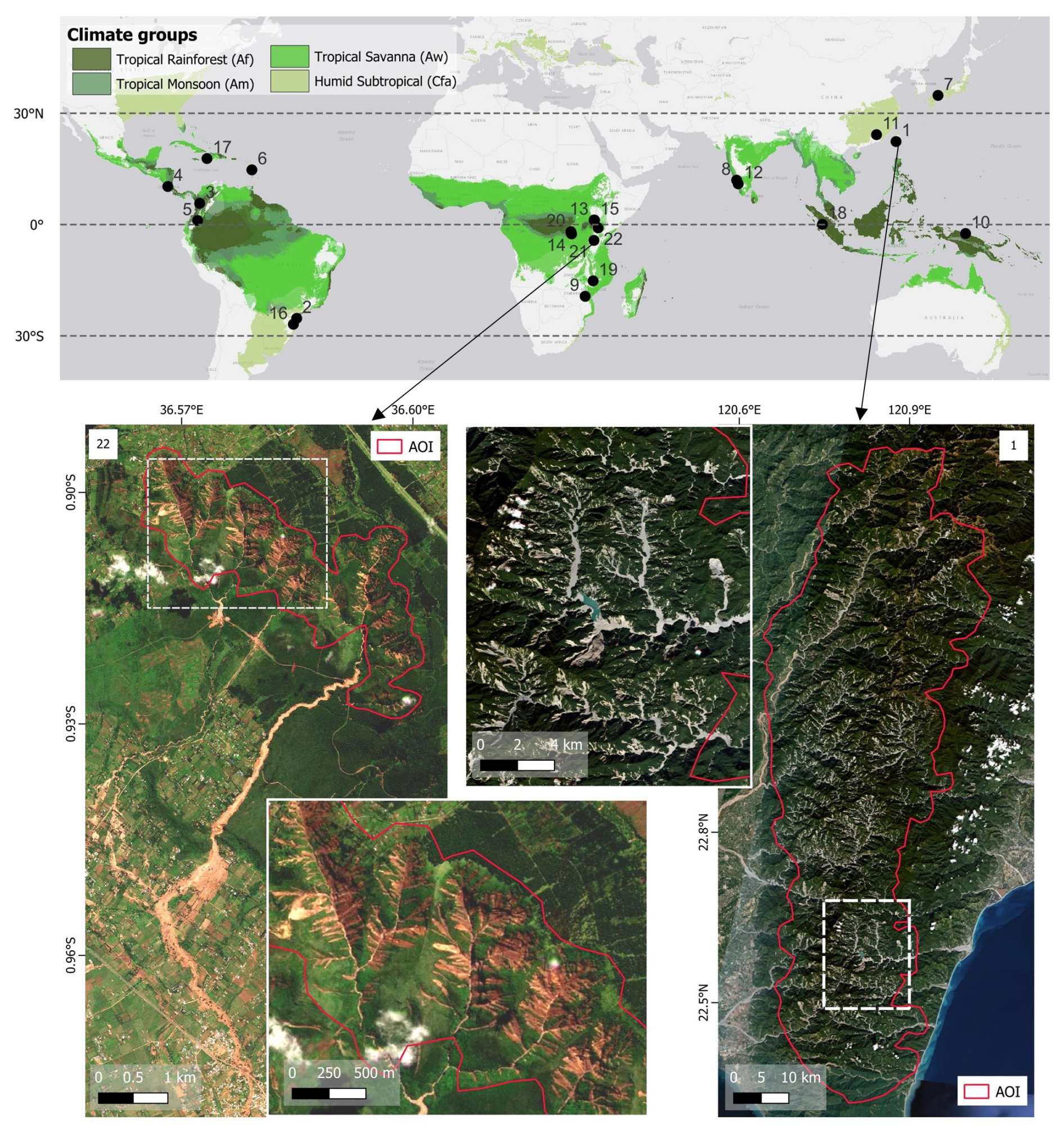
Figure 3Locations of the 22 HTCs compiled in our database in tropical and humid subtropical regions; event numbers correspond to those in Table A1. The largest event was in Taiwan in 2009 (Event 1 in overview map and in Table A1) with an AOI of 3827 km2, and the smallest was in Kenya in 2024 (Event 22) with an area of 6 km2. Satellite images: Planet Team (2017).
3.1 Database compilation
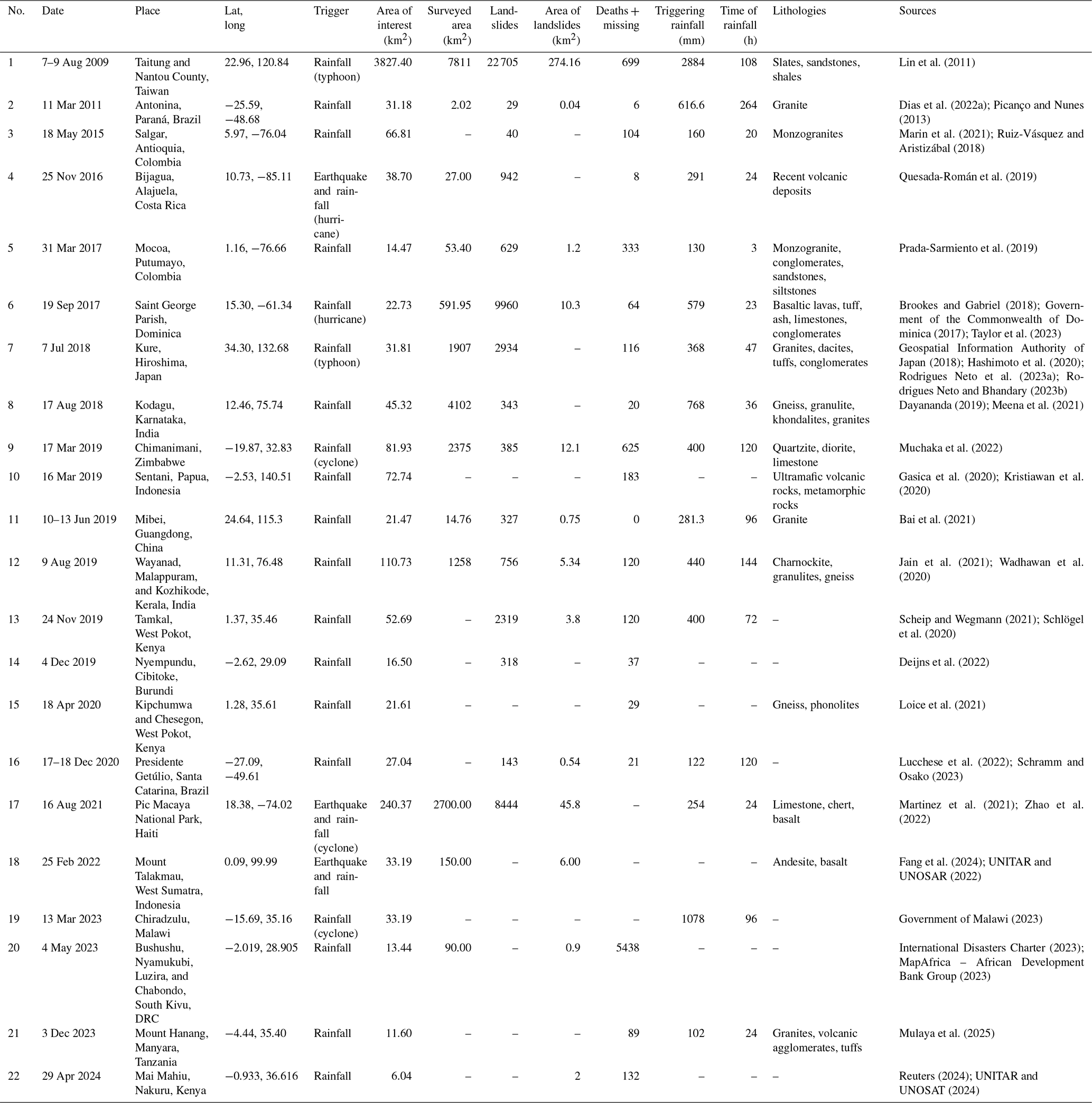
We compiled a database of 22 HTCs that occurred between 2009 and 2024 in tropical or humid subtropical mountains as defined by Peel et al. (2007) (Fig. 3). We consulted multiple sources, including disaster databases such as Desinventar (Desinventar Sendai, 2024), the Landslide Blog (Petley, 2024), and the Disaster Charter (International Charter Space & Major Disasters, 2020); local reports; and optical satellite imagery from Planet (Planet Team, 2017) at a 3 m resolution. We cross-checked all events using the scientific literature and technical reports to compile detailed information, including the number of fatalities, affected area, and number of landslides. The trigger for each event – classified as rainfall or rainfall and earthquake – was adapted from these sources. For rainfall-triggered events, we gathered data on rainfall intensity and reported duration. Where stated, we included information about the dominant lithology of the affected areas (Table A1).
We have delineated an area of interest (AOI) for each event (red polygons in Fig. 3). With a focus on the source areas of cascading hazards instead of their full extent, we excluded areas affected solely by sediment runoff or deposition. Thus, we manually delineated the areas with visible entrainment of hillslope debris flows into channels as AOIs from Planet satellite imagery. We excluded areas without a clear coupling between slopes and channels or those dominated solely by channel or fan processes.
3.2 Terrain, rainfall, and sediment data analysis
3.2.1 Topography and sediment connectivity
We extracted local slope and drainage area from 12.5 m digital elevation models (DEMs) derived from ALOS PALSAR (ASF DAAC, 2014). Soil granulometry data (percentages of clay, silt, and sand) were obtained from the SoilGrids database (Poggio et al., 2021) at a 250 m resolution, averaged for a depth of 2 m, and rescaled to match the DEM resolution. We followed Cavalli et al. (2013) to estimate sediment connectivity from the DEM. The sediment connectivity (IC) is a dimensionless index that estimates the linkage between upslope and downslope components of connectivity. The upslope component depends on the slope gradient and contributing area, while the downslope component is influenced by flow path length and slope at a given location. Sediment connectivity can be assessed relative to specific target locations, such as catchment outlets.
We computed sediment connectivity at two levels: “IC slopes” refers to the connectivity measured in the hillslopes using all pixels located in the drainage network as target locations, and “IC drainages”, which refers to the connectivity of the pixels corresponding to the drainage network, was measured using the basin outlets as the targets. We used the SedInConnect tool (Crema and Cavalli, 2018) to compute the IC values of the two levels.
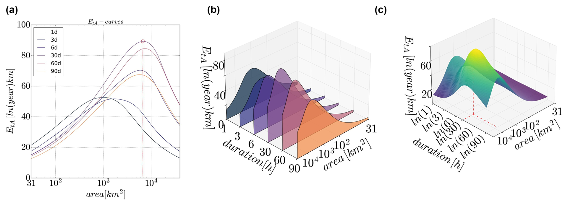
Figure 4(a) EtA curves of rainfall extremity for different durations and areas. (b) EtA curves aligned per duration, normalized with respect to the highest EtA per duration and area. (c) Values from (b) interpolated on a grid of logarithmic values of durations and area. The xWEI is the area under the curve and describes the extremity of the rainfall across duration and extension.
3.2.2 Rainfall analysis
We extracted CHIRPS gridded daily rainfall data (0.05° resolution, i.e. ∼ 5.5 km at the Equator) from 1981 to 2024 to estimate the rainfall intensity and extremeness in HTCs across spatial and temporal scales.
We began by analysing the relationship between the intensity of triggering rainfall and that of antecedent rainfall. To do this, we aggregated daily rainfall records, provided in millimetres per day (mm d−1), defining triggering rainfall as either the rainfall accumulated on the event day alone or the total rainfall accumulated over the event day and the 2 preceding days to account for uncertainty about the date of the event occurrence. Antecedent rainfall is defined as the total rainfall accumulated over the 90 d preceding the event. This 90 d period captures seasonal-scale rainfall accumulation in tropical regions associated with monsoonal or ITCZ dynamics. Furthermore, many authors consider the 90 d window to be a representative and widely used measure of antecedent rainfall in landslide hazard (Cardinali et al., 2006; Zêzere et al., 2005).
To assess how extreme these rainfall events are, we computed the cross-scale Weather Extremity Index (xWEI) (Voit and Heistermann, 2022), which defines extremeness (EtA) as the product of rarity (return periods) and affected area extent (Müller and Kaspar, 2014). A high xWEI indicates extreme rainfall over different durations and a large area (Voit and Heistermann, 2022). For this, we aggregated six different durations (1, 3, 6, 30, 60, and 90 d) and analysed each of them by extracting yearly maxima for each CHIRPS cell and then fitting a duration-dependent generalized extreme value (dGEV) distribution (Koutsoyiannis et al., 1998), which accounts for dependencies across durations. For example, an extreme daily rainfall value is likely also contained in an extreme 3 d rainfall value. To assess which rainfall duration may have influenced the occurrence of the HTCs most, we calculated the extremeness (EtA) for each duration separately (Fig. 4a and b). We used a day search window of 3 times the duration (e.g. 9 d for a 3 d duration) before the event and aggregated the rainfall within this search window by a moving window for each duration. We then computed the extremeness of the entire rainfall event following Müller and Kaspar (2014) (Fig. 4c). We also computed daily xWEI values for the full CHIRPS dataset. The resulting time series helped to identify the antecedent rainfall leading up to HTCs and to undertake comparison with similar past events. To compare the EtA values across different regions, we normalized these values to the maximum EtA found in the whole CHIRPS dataset for each AOI.
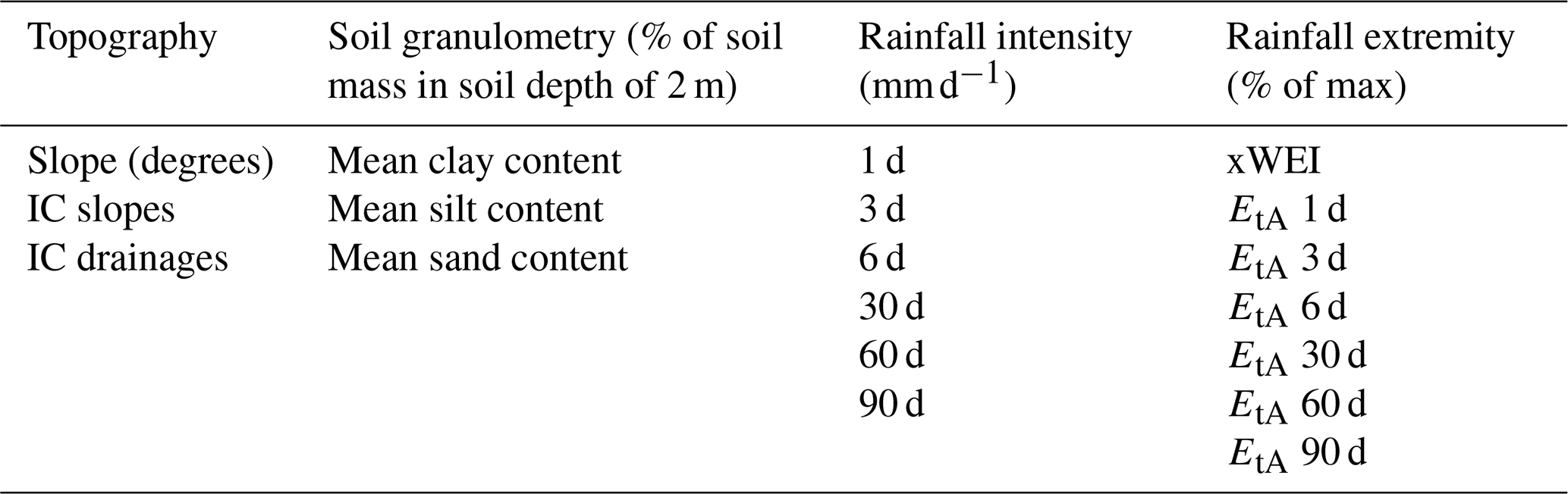
Table 2Variables used in the k-means cluster analysis, divided into the four main ingredients for HTC generation: topography, soil composition, and rainfall, expressed as intensity and extremity.
3.3 Clustering analysis
We performed a k-means clustering analysis to identify patterns and similarities among study regions, using 19 topographic, granulometric, and rainfall variables, which are shown in Table 2. To avoid relying solely on mean values of the variables per AOI, we clustered using CHIRPS pixels as the sample size (∼ 5.5 km resolution). This approach resulted in a variable number of samples per study area, ranging from 2 to 256 pixels, depending on the spatial extent of the different AOIs.
Before clustering, we applied principal component analysis (PCA), which employs singular value decomposition (SVD) to reduce the number of dimensions of the dataset while retaining its variance. We used the prcomp() function from the stats package in R. Before running PCA, we standardized the dataset to ensure all variables had equal weight in the analysis. We selected the first five principal components (PCs), which together explained 87 % of the total variance, as input for the clustering analysis.
To determine the optimal number of clusters, we evaluated the silhouette score, a metric that assesses how well each data point fits within its assigned cluster relative to other clusters. For clustering, we used k-means with Euclidean distance, using the kmeans() function from the stats package in R. After defining the clusters, we examined the distribution of key variables within each group and analysed the PCA loadings that show how original variables contribute to each principal component. This allowed us to identify the commonalities and differences across groups of documented events.
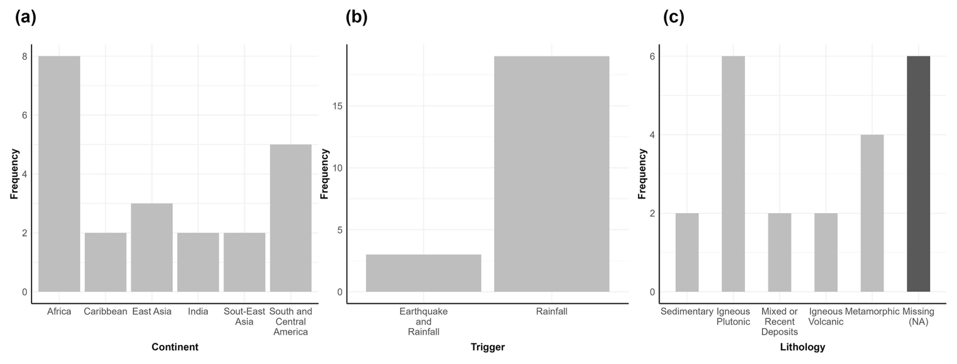
Figure 5Locations, triggers, and dominant lithology in areas affected by a global sample of 22 HTCs.
4.1 General analysis of database
We compiled 22 HTC events across all tropical world regions (Fig. 5a). We refer to each HTC in terms of its AOI followed by its number in parentheses in Table A1. The median size of all the AOIs that we mapped is 33 km2, although their sizes vary greatly. The smallest AOI is Kenya (22); that was triggered by an intense, localized rainstorm and had an area of 6 km2, though the resulting debris flow travelled some 10 km (UNITAR and UNOSAT, 2024). The largest AOI is Taiwan (1), triggered by Typhoon Morakot, with HTCs occurring in an area of > 3800 km2 (Fig. 3). According to Lin et al. (2011), the total affected area, including deposition zones not considered in our AOI, was 7811 km2.
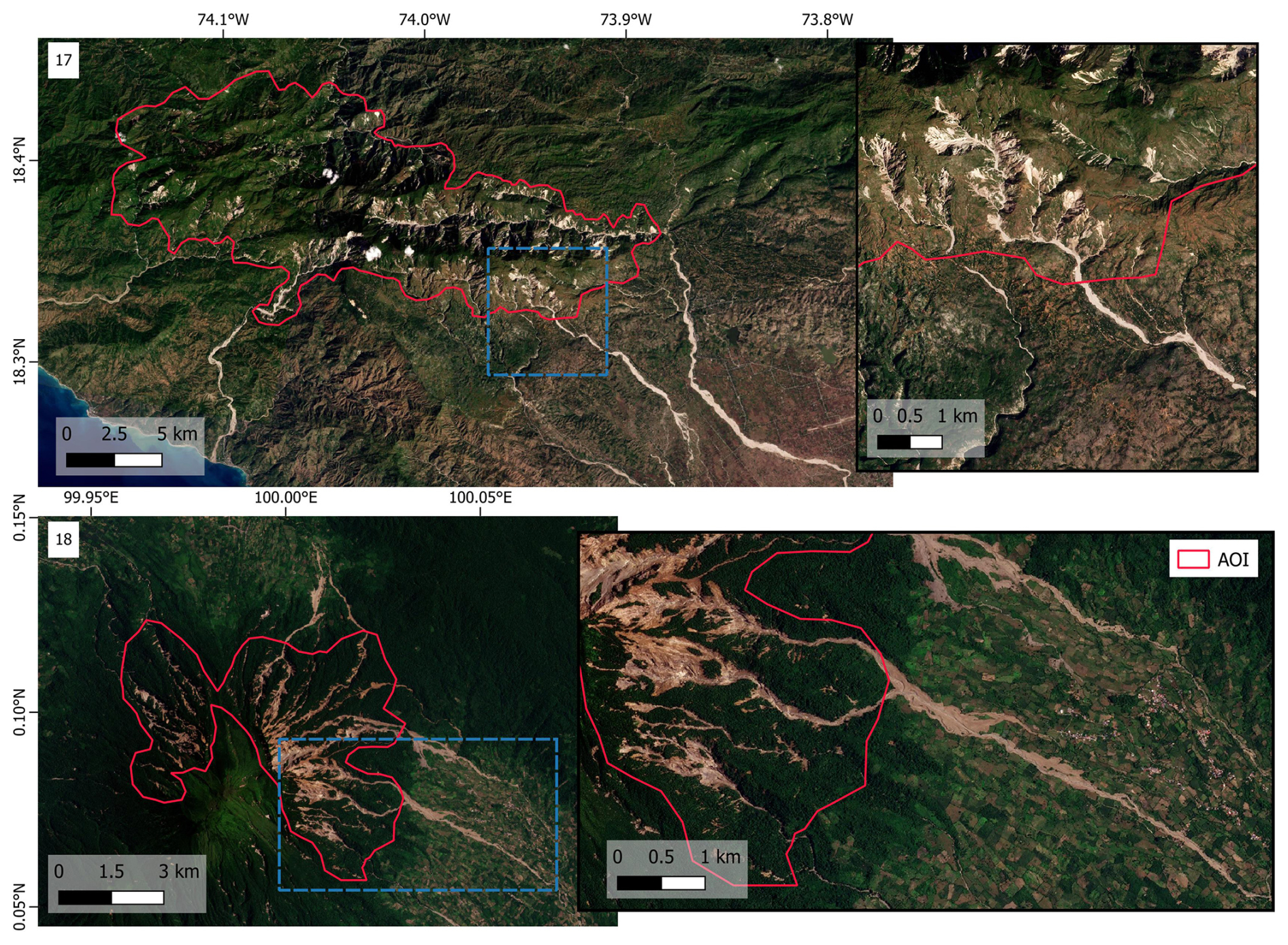
Figure 6Two HTCs reported to be triggered by earthquakes. The long runouts indicate highly mobile flows, suggesting the combined action of the seismic shaking with nearly coincident rainstorms. Top: overview (left) and zoomed-in view (right) of Pic Macaya, Haiti, in 2021 (17); bottom: Mt. Talakmau in Indonesia in 2022 (18). Dashed blue rectangles indicate the zoomed-in areas. Satellite images: Planet Team (2017).
We found that 19 of the 22 documented HTCs were triggered by rainfall, and 5 of these were associated with tropical cyclones. The remaining 3 events were triggered by the combined effects of earthquakes and rainfall (Fig. 5b), although in varying sequences. The 2016 event in Bijagua, Costa Rica (4), was attributed to Hurricane Otto, but the area was shaken by a Mw 5.4 earthquake 4 months before (Quesada-Román et al., 2019). The 2021 event in Pic Macaya, Haiti (17), was described as co-seismic landslides triggered by the Mw 7.2 Nippes earthquake by Martinez et al. (2021) and Zhao et al. (2022). However, both sources report that Tropical Cyclone Grace passed through the region 2 d later. While noting the cyclone, they remain inconclusive about the trigger because of a lack of satellite imagery between the earthquake and subsequent rainfall. Similarly, the 2022 Mont Talakmau event in Indonesia (18) is classified as co-seismic landslides triggered by the 6.2 Mw Sumatra earthquake (Fang et al., 2024), with no explicit links to rainfall. However, some rain had occurred in the days prior and on the day of the event. In both the Haiti and Indonesia cases, the high mobility of the landslides and their transition into channelized debris flows that travelled over 10 km (Fig. 6) indicate some contribution of rainfall. It is likely that both seismic shaking and rainfall played a role in triggering and sustaining the HTCs.
The dominant lithologies for a dozen of the HTCs were grouped into general categories (Fig. 5c), and the results show that plutonic rocks were the most common, followed by metamorphic rocks. For Japan (7), Rodrigues Neto et al. (2023b) highlighted that granitic and granodioritic rocks in the area were more susceptible to landslides than volcanic rocks because the former were weathered into permeable and brittle sand. Similarly, for Colombia (5), García-Delgado et al. (2019) reported that highly tectonically weathered granitic rocks were highly susceptible to landslides, while sedimentary rocks promoted slope failures through water infiltration along weathered shear fractures.
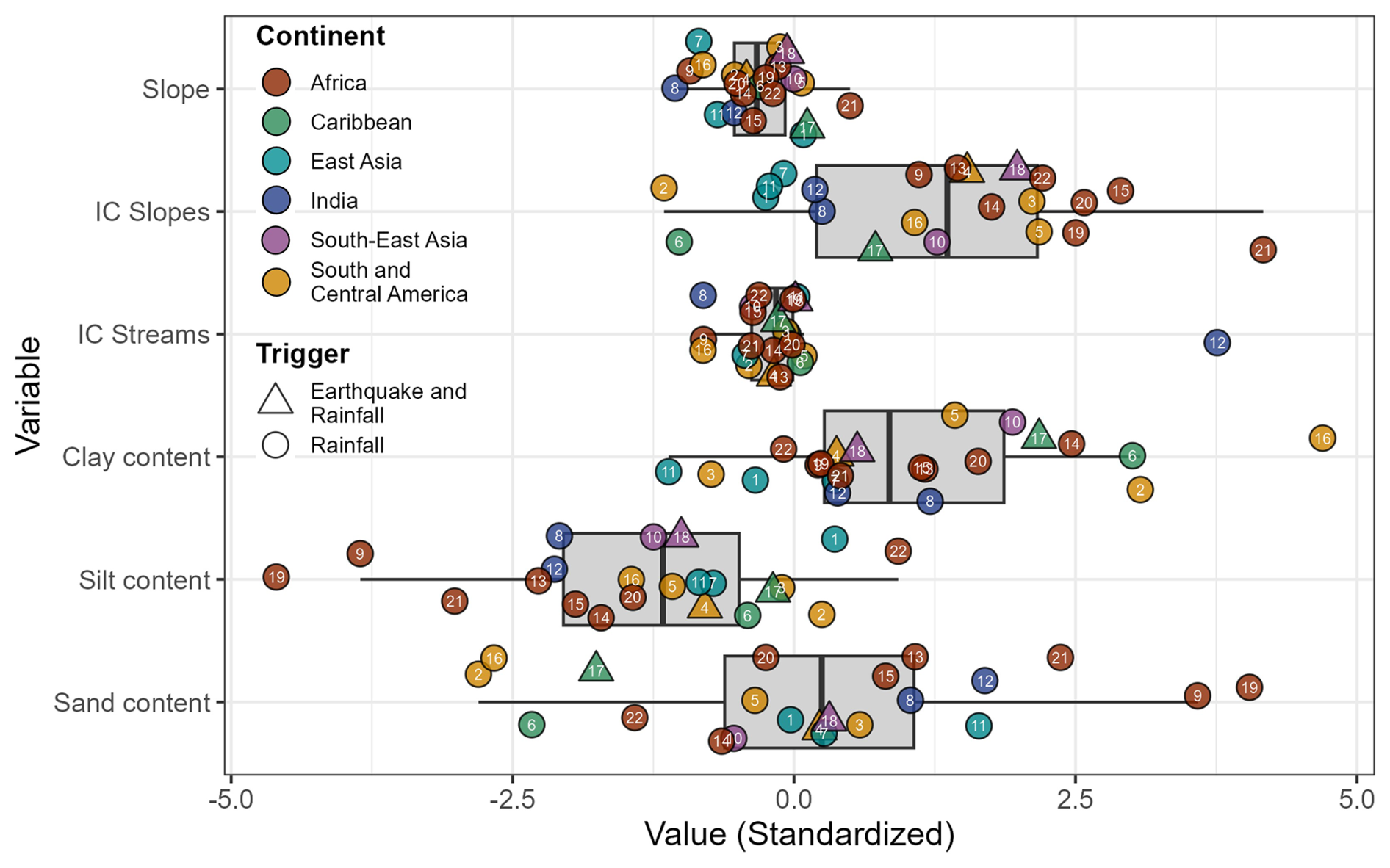
Figure 7Distribution of terrain and sediment granulometry variables of 22 HTCs, standardized to the global mean across all study areas: zero refers to the mean, and units are standard deviations. Circles and triangles are mean values for each study area, and numbers correspond to the event (see Table A1). Box-and-whisker plots show medians as thick vertical lines; boxes span the lower and upper quartiles, and whiskers extend over 1.5 times this interquartile range.
Landslide density varied across events, with 10 events having mapped landslides of different extents. Reported landslide densities thus vary widely, ranging from 0.08 landslides km−2 in India (8), where over 300 large landslides were scattered across the 4100 km2 Kodagu rural district (Meena et al., 2021), to 35 landslides km−2 in Costa Rica (4), where more than 900 small shallow landslides happened over 27 km2 on the slopes of Miravalles volcano (Quesada-Román et al., 2019).
4.2 Topography, sediment, and rainfall characteristics
4.2.1 Topography and sediment characteristics
There is substantial variability in the terrain and sediment characteristics across the AOIs, partly because of the large differences in their size (Fig. 7). The mean slope across the regions had moderate spreads, varying from 14.7 to 37.1° with a median of 26.3°. While sediment connectivity of streams (IC streams) shows only moderate spread, the IC of hillslopes (IC slopes) varies more widely, with a high spatial variability across each AOI. No single granulometric composition dominates across the AOI, as clay, silt, and sand content varies greatly.
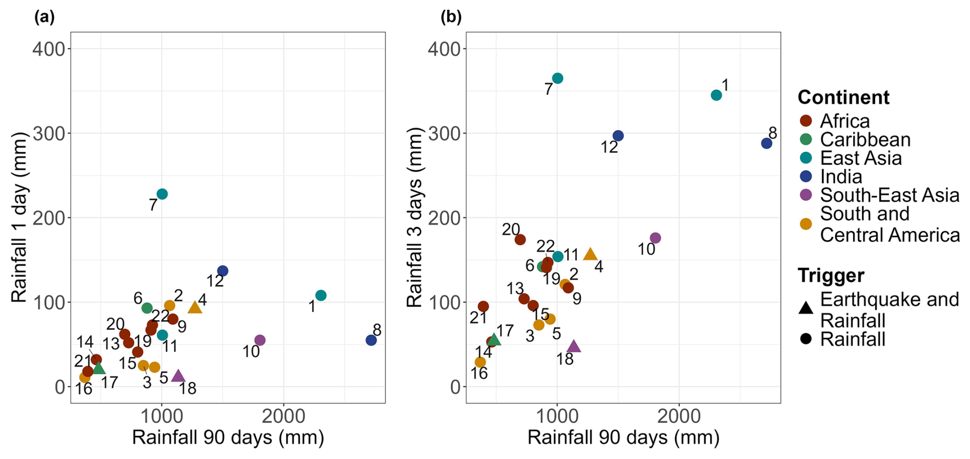
Figure 8Relationship between 90 d antecedent rainfall and triggering rainfall of 1 d (a) and 3 d (b) before the event based on CHIRPS rainfall data for each AOI. The numbers correspond to AOI numbers in Table A1.
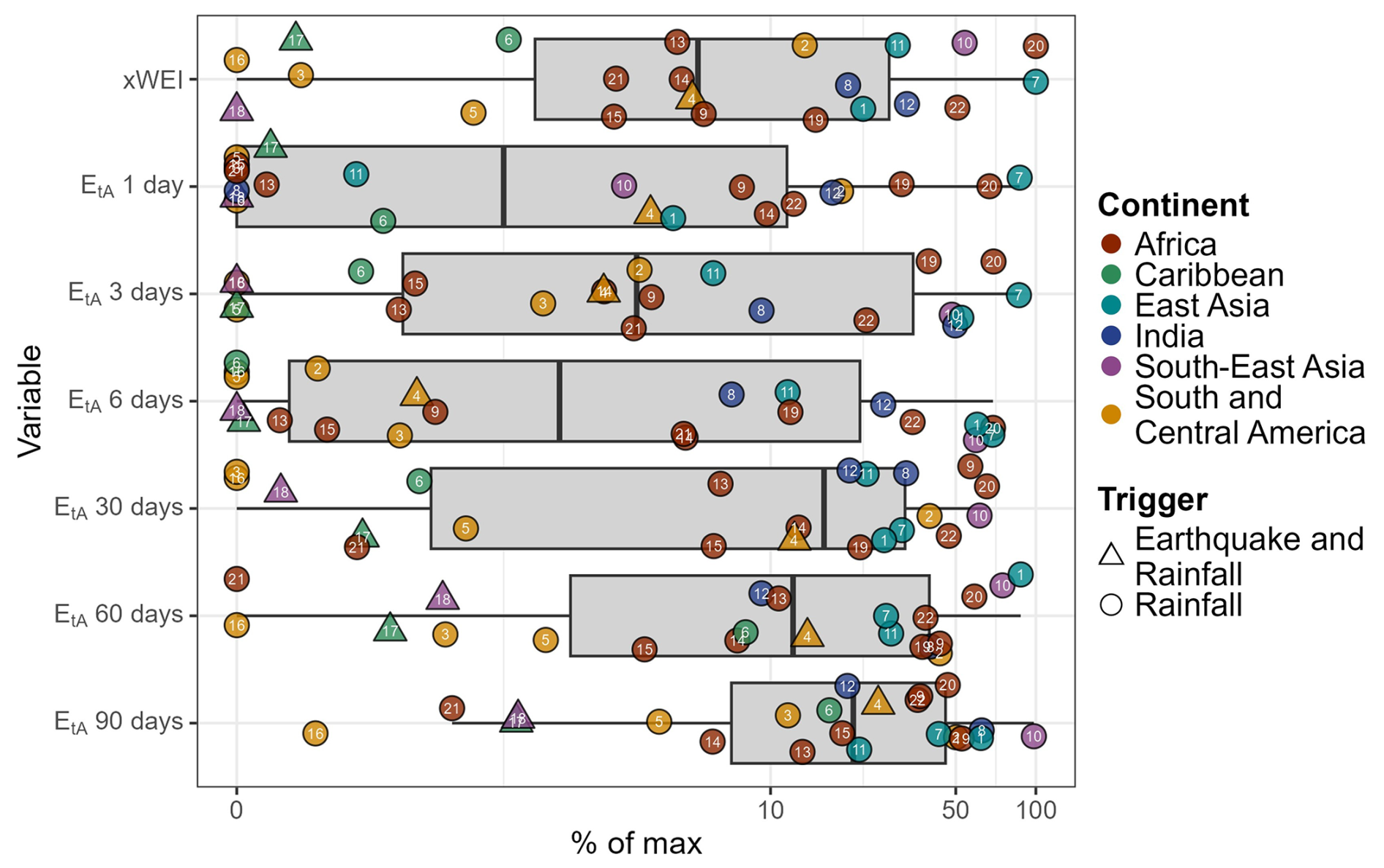
Figure 9Distribution of the xWEI rainfall extremeness index for rainfall of 1 to 90 d duration and various spatial extents, along with the corresponding extremity (EtA). All values are normalized to the maximum recorded for each AOI, such that a value of 100 % is the most intense rainfall observed in the AOI between 2000 and 2024. See Fig. 7 for boxplot explanations and Table A1 for numbers.
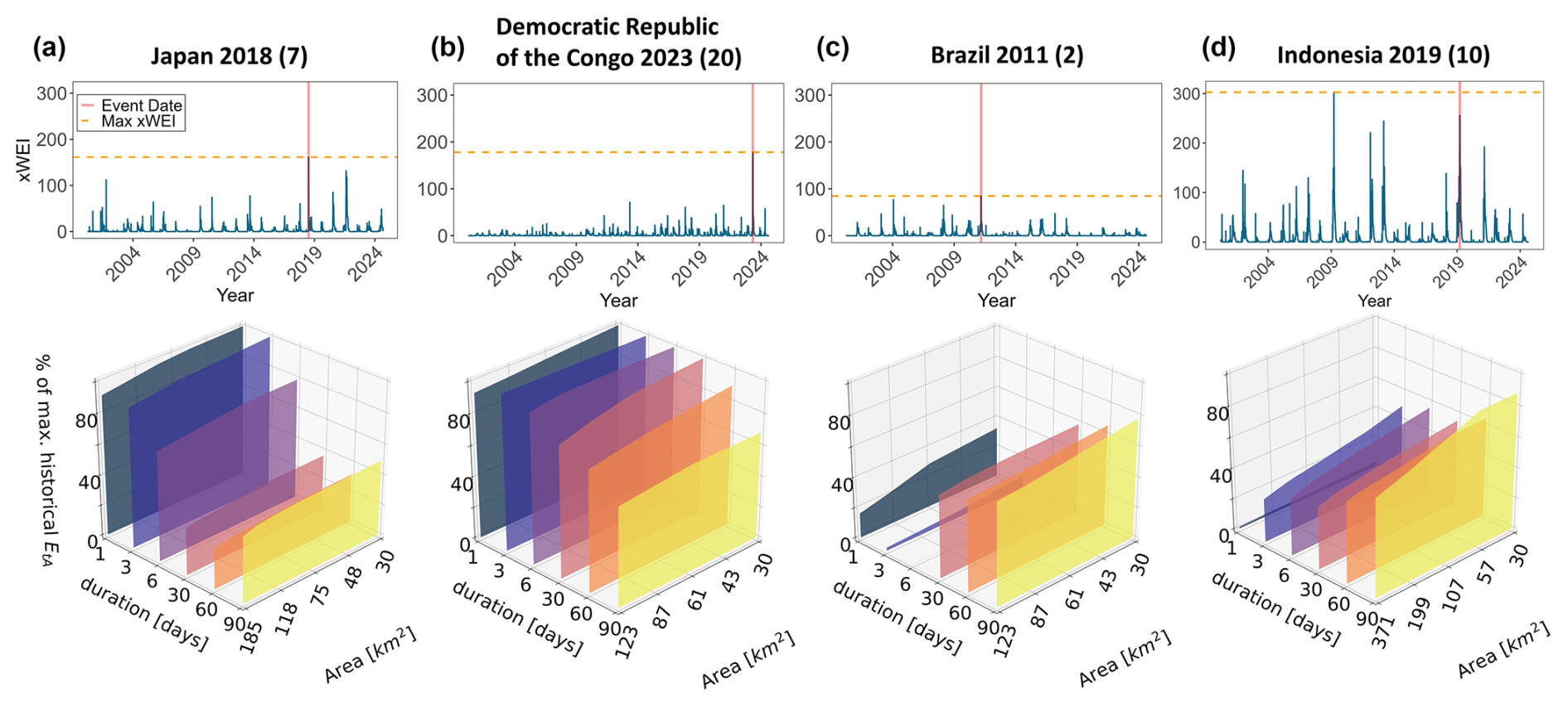
Figure 10Summary of rainfall time series and extremes of four selected HTCs. (a–d) Upper plots show time series of xWEI between 2000 and 2024, with the day of the HTCs highlighted and compared with the highest recorded xWEI; lower plots show triggering rainfall intensity (EtA) of the HTCs across different rainfall durations and extensions. The xWEI values vary in scale across AOIs because of their size and the fitted dGEV distributions. In (a) and (b), short-term rainfall (1–6 d) contributed most to event extremeness, whereas in (c) and (d), long-term rainfall contributed more.
4.2.2 Rainfall characteristics
Rainfall characteristics are analysed in terms of intensity (Fig. 8) and extremity (Figs. 9 and 10). Figure 8 shows the relationship between 1 and 3 d with the 90 d rainfall accumulation for each AOI. The triggering rainfall intensities varied between 10 and 100 mm accumulated on the day of the event, and 90 d accumulated totals were from 700 to 1300 mm. The lowest triggering and antecedent rainfall for a HTC was associated with an event in Brazil (16), with only 11 mm on the event day and 370 mm accumulated over the 90 d before. The data show a weak linear relationship between triggering and antecedent rainfall (Fig. 8, r = 0.31 for 1 d rainfall; r = 0.7 for 3 d rainfall). AOIs in East Asia and India stand out from the rest of the regions due to the intensity of their antecedent and triggering rainfall, especially at the 3 d duration, which is notably higher than in other regions. This includes Taiwan (1), triggered by Typhoon Morakot; India (8 and 12), triggered by intense monsoon rainfalls, with the latter having had a 90 d accumulated rainfall of 2717 mm, the highest of the database; and Japan (7), caused by Typhoon No. 7, which dropped 228 mm in a single day and 355 mm in 3 d, and was the most intense triggering rainfall recorded in the database.
No events were reported following a combination of high antecedent rainfall and low triggering rainfall or following intense short-term rainfall combined with low antecedent rainfall.
In addition, Fig. 9 summarizes the extremity of rainfall events, analysed using the xWEI of each event and the corresponding EtA values for various rainfall durations. Only 2 of the 22 HTCs were triggered by the most extreme recorded rainfall event ever measured in their AOI, i.e. the Democratic Republic of the Congo (20), and Japan (7), both of which had high extremeness in their 1 and 3 d rainfall durations. Only four events were triggered by events with xWEI values at more than half of the most extreme recorded, and half were below 10 % of the most extreme one. Overall, the extremeness of the rainfall that triggered the events in our database is greater in the long term (30, 60, and 90 d) than in the short term (1, 3, and 6 d). Among all the durations, the extremeness in the 1 d duration is the lowest and that in the 90 d duration is the highest. Events triggered by earthquakes and rainfall remain in the region of low–medium to low rainfall accumulation on both axes.
Figure 10 shows the time series of xWEI and rainfall intensity (EtA) across different durations for four HTCs triggered by extreme rainfall events. The events in Japan (7) and the Democratic Republic of the Congo (DRC; 20) coincided with the highest xWEI on record. However, three other events – Indonesia (10), Brazil (2), and Kenya (22) – occurred within 3 d before the peak of another very extreme rainfall episode. These events were triggered before the rainfall reached its maximum intensity, indicated by their lower xWEI values on the day of occurrence. When comparing the xWEI values of all other HTCs with their time series, only 3 fell within the top 100 most extreme events.
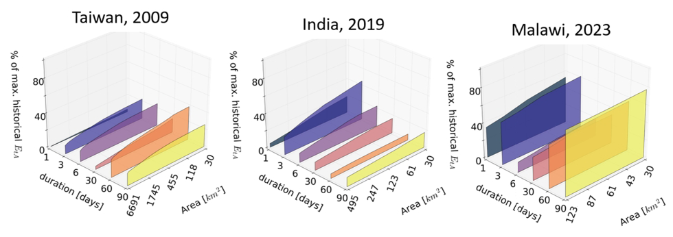
Figure 11Triggering rainfall intensity (EtA) of three HTCs across different rainfall durations, highlighting higher extremity values across smaller areas.
The extremity index xWEI also allows us to underline the localized nature of the rainfall that triggered the HTCs. In all the AOIs, the extremity was higher at the local scale than in the regional one. Figure 11 shows three examples of this: in Taiwan (1), the most extreme rainfall occurred over 3, 6, and 60 d durations, with peak intensities concentrated over 118 km2, or only 2 % of the total affected area. In India (12), the highest extremity was observed over 3 d, with its peak rainfall affecting 25 % of the area. In contrast, in Malawi (19), the most extreme rainfall was over 90 d, with rainfall distributed more evenly across the AOI. However, even in this case, short-term extremes of 1 and 3 d were more localized and detected using CHIRPS data despite their coarse resolution.
4.2.3 Relationships between topography, sediment, and rainfall characteristics
Figure 12 shows the correlation between topographic, sediment, and rainfall values. The rainfall was assessed in terms of both intensity and extremity at the CHIRPS pixel scale (∼ 5.5 km2), where each pixel had different topographic and rainfall values but all pixels from the same AOI had the same EtA and xWEI values (Fig. 12). We stress the lack of correlation between the sediment connectivity (IC) of slopes and the rainfall extremity (xWEI) with all other variables. The ICs of channels and clay content are negatively correlated with both the rainfall intensity and the rainfall extremity of specific rainfall durations, indicating that AOIs with clay-rich soils and higher sediment connectivity in streams are triggered by less intense and less extreme rainfall.
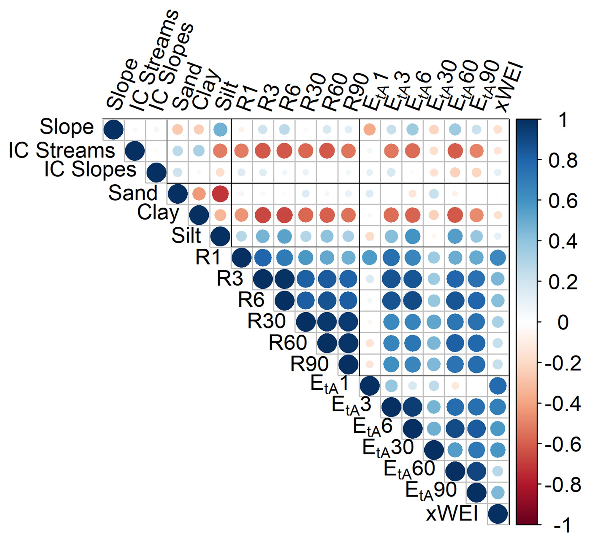
Figure 12Correlation matrix for terrain and rainfall variables measured at the scale of the CHIRPS pixels. The darker lines divide the variables into groups: topography, sediment granulometry, rainfall intensity, and rainfall extremity. Ri variables refer to the accumulated rainfall the corresponding number of days, i, before the HTCs. EtAi refers to the percentage of the extremity of the corresponding rainfall duration in i days, compared to the maximum recorded.
4.3 Cluster analysis
The silhouette scores were used to determine the optimal number of clusters. Although the analysis suggested an optimal number of seven clusters, we chose to limit the data to three groups to prevent overfitting and because of the small sample size. Clusters were defined based on the first five principal components, which together explain 87 % of the total variance.
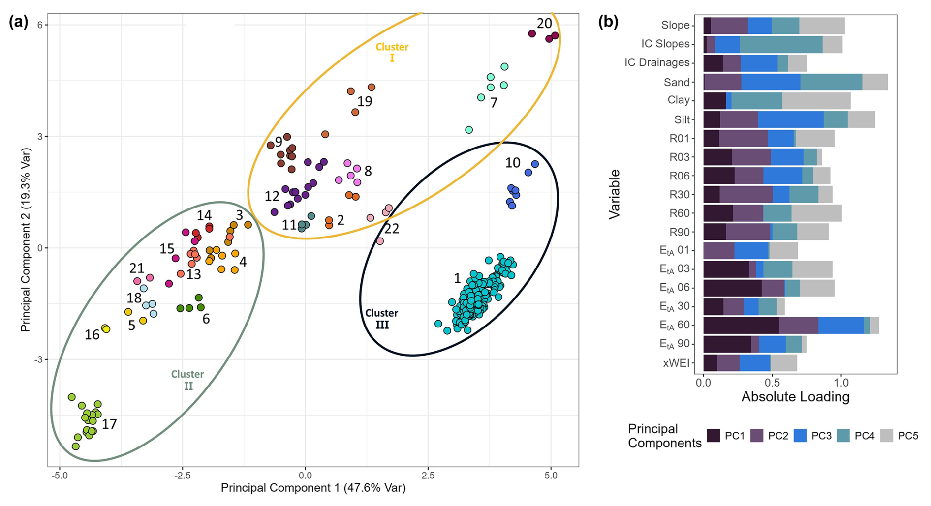
Figure 13(a) Distribution of HTCs based on their first two principal components (PC1 and PC2), with points colour-coded by the area of interest (AOI) and numbered according to Table A1. Ellipses outline the extent of each of the three k-means clusters. (b) Variable loadings of the five principal components used in the clustering analysis, indicating the contribution of each standardized variable to the PCs.
Figure 13a shows a scatterplot of all analysed pixels in the space defined by the first two principal components (PC1 and PC2), which account for 48 % and 19 % of the variance, respectively. Each point represents a pixel, and the ellipses outline the extent of each cluster. Figure 13b shows the variable loadings of each PC, where PC1 is primarily influenced by variables of rainfall extremity across different durations and PC2 is associated with rainfall intensity and terrain characteristics such as soil granulometry and slope.
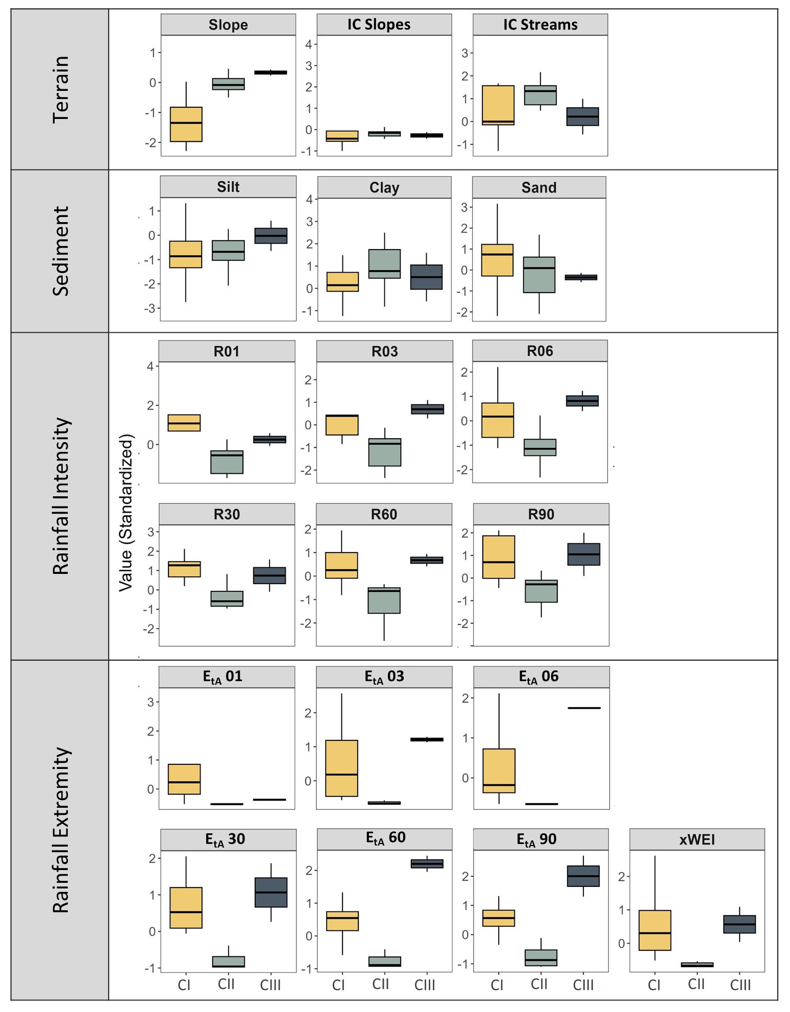
Figure 14Distribution of standardized values for terrain, sediment, and rainfall variables across the three identified clusters (CI, CII, CIII). Boxplot colours and cluster labels match those shown in Fig. 13a.
Figure 14 shows the distribution of all 19 standardized variables across the three clusters, enabling a direct comparison of how variables differ between them. For instance, Cluster I includes nine AOIs, characterized by gentle slopes, sandy and silty soils, and HTCs triggered by intense rainfall, particularly for a 1 d duration. Lithologies are predominantly granitic and metamorphic. Cluster II includes 10 AOIs, including the three events triggered by both rainfall and earthquakes. These AOIs have intermediate to steep slopes, high stream sediment connectivity, and fine-grained soils (silt and clay). These HTCs were mostly triggered by rainfall events of lower intensity and extremity, especially over short durations. Their lithologies include sedimentary rocks, volcanic deposits, gneiss, and granite. Cluster III contains two AOIs with exceptionally steep slopes, high silt content, and HTCs triggered by prolonged and extreme rainfall over 60–90 d.
In this section we aim to explore the key findings from our analysis of 22 hillslope torrential cascades (HTCs) in tropical regions between 2009 and 2023. We focus on understanding the similarities and differences in the rainfall conditions that trigger these events, alongside the susceptibility factors like topography, soil granulometry, and sediment connectivity.
None of the analysed HTC events was triggered solely by intense short- or long-term rainfall; instead, a combination of both played a role. However, rainfall extremeness was greater over longer durations (30, 60, and 90 d) than in the short term. While short-term rainfall contributed to the events, HTCs often followed particularly extreme rainy seasons. This long-term rainfall accumulation may contribute to reducing soil stability, increasing the likelihood, number, and mobility of hillslope debris flows triggered by intense (but not necessarily extreme) rainfall events and increasing runoff due to soil saturation. This is supported by other studies about the role of antecedent rainfall conditions in phenomena like landslides and torrential flows (Guzzetti et al., 2008; Kim et al., 2021; Prenner et al., 2019).
To explore the unusually low rainfall intensities that appeared to trigger some events, we compared CHIRPS rainfall estimates with reported rainfall accumulations in event reports or descriptions. These reported triggering rainfall values ranged from 1 to 43 mm h−1. Yet, comparing these records is difficult as some rely on rain gauge measurements taken far from the event sites, while others use radar-based estimates or satellite imagery. When comparing these reports with CHIRPS estimates, we found large differences, especially for short-term rainfall. For example, Velásquez et al. (2020) reported that the 2015 Colombia event (3) was triggered by a localized convective storm of 180 mm of rain overnight, based on radar data. However, CHIRPS estimated 25 mm on the event day. Similarly, for the 2020 Brazil event (16), CHIRPS estimated 11 mm on the event day, while Michel et al. (2023) reported 124 mm in a single day based on local rain gauge data. These inconsistencies were evident throughout the database, with absolute differences between reported and actual values decreasing as the accumulation period increased. This finding aligns with that by Urrea et al. (2016), who compared CHIRPS rainfall estimates with gauge measurements in Colombia and found that the coarse resolution of CHIRPS tends to underestimate short-term rainfall variability, smoothing localized extremes while performing better at monthly and annual scales, as errors decrease.
Only two HTCs in our database were triggered by the most extreme rainfall recorded in the AOI across all durations from 1 to 90 d; three others occurred just before the peak of very extreme events. Still, most (i.e. 15) HTCs were associated with rainfall that had an extremity index < 25 %. This finding suggests that these events occurred in supply-limited watersheds and thus were a consequence not solely of extreme rainfall, but also of sediment availability. The frequency of torrential events in supply-limited basins depends on the specific sediment recharge rates, producing less frequent but more extreme events than transport-limited basins do, where unlimited sediment supply means torrential events are triggered more by critical rainfall (Jakob and Hungr, 2005). Some observations in temperate mountainous catchments highlight the seasonal nature of cycles of sediment recharge, storage, and flushing, where torrential hazards are triggered by critical discharge, capturing sediment from channel storage zones (Theule et al., 2012). While this recharge–flushing dynamic is established in temperate mountain settings, comparable data are scarce in tropical environments, where the timing and magnitude of sediment recharge cycles remain under-characterized.
Moreover, the tropics have some of the highest rates of biogeochemical weathering (Syvitski et al., 2014). Sustained precipitation and humidity have led to the development of weathered soil profiles tens of metres thick with distinct material contrasts between colluvial layers, saprolitic and residual soils, and bedrock. These contrasts favour slope failure with substantial amounts of poorly consolidated material (Amarasinghe et al., 2023). In tectonically active tropical mountains such as parts of the Andes, the Ethiopian Highlands, or the New Guinea Highlands, physical weathering is also important, while volcanic activity and seismicity provide mobile sediment. These high sediment production rates in the tropics could mean that HTCs can have shorter recurrence periods than in temperate areas.
In three cases, both earthquakes and rainfall coincided as possible triggers. One case involved intense rainfall triggering a HTC in terrain that had been weakened by a previous earthquake, as in Costa Rica (4) (Quesada-Román et al., 2019). In Indonesia (18), a rainy season was followed by an earthquake that triggered the HTCs. A third case features the reworking of earthquake-triggered landslide sediment by subsequent rainfall, i.e. Haiti (17). In all three cases, the long-term rainfall extremity was higher than the short-term one, which was neither extreme nor intense. We infer that the sequence of closely timed earthquakes and rainfall triggers may matter less for triggering HTCs, as long as they follow extended rainy seasons.
Among the different topographical characteristics of the different AOIs, the sediment connectivity (IC) of hillslopes to the drainage network did not show any clear relationship with any other terrain or rainfall variable, most likely due to its high variability within each study area. Still, we think that it would be worth further investigating the relationship between the occurrence of HTCs and the IC of hillslopes on a more detailed scale, specifically by analysing how the IC varies across the terrain within each study area and how it relates to the runout of the HTCs.
In our database, around one-third of the AOIs are in Africa, and they stand out for their steep terrain and particularly coarse soils. However, finding technical and academic information about them was difficult, as most references were limited to news reports (Table A1). The high susceptibility of these regions and the scarcity of detailed data make the situation even more critical, especially considering the recurrence of such events. For example, Jacobs et al. (2016) documented landslides and flash floods in the Rwenzori Mountains, along the border between Uganda and the Democratic Republic of the Congo, from 1929 to 2014. They found that debris-rich flash floods were the second deadliest kind of event in the region but also pointed out the data gaps in tropical Africa, largely due to the coarse resolution of global datasets, which are often the only available sources of information. The susceptibility of tropical Africa is expected to rise as a response to a warming climate: projections suggest that short-term rainfall events in Eastern Africa could become more intense, potentially exceeding long-term rainfall accumulations (Palmer et al., 2023). These findings should serve as a call to increase efforts to understand the occurrence of HTCs in tropical Africa.
Our cluster analysis reveals three groups of HTCs based on their terrain features, their sediment composition, IC, and the intensity and extremity of triggering rainfall. Cluster I includes events triggered by intense rainfall in both the short and the long term, but particularly in the short term, occurring on gentle slopes with predominantly sandy and silty soils. The susceptibility of these areas may be linked to the presence of residual soils derived from granitic rocks. In China (10), Bai et al. (2021) described soils derived from granite, consisting of residual soil overlying completely weathered granite. The upper layer had higher cohesion but was weakened when saturated, while the underlying granite was more permeable. These differences influenced infiltration, pore pressure, and slope stability, with landslides often occurring at their interface. Similarly, in Brazil (2), Picanço et al. (2019) found a transition in granite-derived soils from silty-clay topsoil to sandier horizons near bedrock, forming slip surfaces. In both cases, abrupt changes at weathering boundaries played a key role in slope failure.
Several other studies also highlight the role of weathered granitic rocks in HTC formation. In Puerto Rico, landslides triggered by Hurricane Maria were primarily in areas underlain by intrusive rocks such as (grano)diorites (Bessette-Kirton et al., 2020). In Colombia, the majority of the most destructive HTCs, locally called avenidas torrenciales, occurred in granitic headwater basins (Aristizábal et al., 2020), and a very similar pattern was also noted in Malaysia (Legiman et al., 2023) and Japan (Chigira, 2001; Chigira et al., 2011; Hirata and Chigira, 2019). Additionally, the spheroidal weathering typical of granite rocks provides large boulders, usually carried in the front of the flows, increasing their destructive power (Hirata and Chigira, 2019; Iverson, 1997). We infer that granitic terrains are particularly prone to HTC occurrence under short-term intense rainfall, even in areas with gentle slopes. However, this may be a particular trait of tropical regions with deeply weathered profiles, as de Haas et al. (2024) noted that, for temperate regions, quartz-rich igneous rocks tend to produce sandy and gravelly soils that are less prone to debris flows compared to regoliths containing clay and silt, abundant in sedimentary and fine-textured metamorphic rocks.
The second cluster includes HTCs in terrain with steep slopes, high stream sediment connectivity, and a diverse range of soil types, primarily silty to clayey. Triggering rainfall in this cluster was less extreme and intense compared to the other groups, particularly in the short term. The lithologies were variable, including sedimentary rocks, recent volcanic deposits, andesites, basalts, gneiss, and granites. This cluster also includes the three events triggered by both rainfall and earthquakes. In summary, clusters I and II indicate that, for HTCs to happen, gentler slopes demand higher rainfall and more channel connectivity, whereas steeper, well-connected terrains require significantly less triggering rainfall.
Finally, Cluster III has two HTCs with exceptionally steep slopes and silt content, where the triggering rainfall was particularly intense and extreme, especially in the long term. The combination of steep terrain, high silt content, and prolonged intense rainfall over 60 to 90 d appears to have contributed to the susceptibility of these areas to HTCs.
The present study analyses information about the interplay between rainfall and topographic and sediment characteristics in triggering and propagating hillslope torrential cascades (HTCs) in tropical mountains. Rather than being driven by a single factor, these events result from a combination of interacting drivers. We show that HTCs are not only the result of extreme precipitation events but, more importantly, a consequence of both long- and short-term rainfall. While intense short-term rainfall can initiate HTCs, prolonged wet periods play a role in reducing soil stability and increasing runoff and sediment mobilization. The majority of events were not triggered by the most extreme rainfall recorded, and we infer that these HTCs occurred in supply-limited basins. The high sediment production rates in tropical environments may lead to shorter recurrence intervals for HTCs compared to temperate regions.
Our analysis also recalls the challenge of capturing rainfall patterns in tropical regions. Differences between CHIRPS rainfall estimates and local measurements indicate that coarse global datasets underestimate short-term rainfall variability, especially in localized, intense rainfall episodes, which commonly occur in mountain regions. This limitation is particularly important in areas where data are scarce and hazard assessments rely on global datasets.
The topographic setting of HTCs is very diverse. The role of sediment connectivity may deserve some future work looking into the coupling of hillslopes to channels in more detail. We also find that many HTCs were tied to deeply weathered granite-derived soils, where intense short-term rainfall following a prolonged rainy season destabilized the soil layer even on gentle slopes.
Cluster analysis revealed similarities between slope, rainfall intensity, and sediment granulometry: in regions with gentler slopes and lower connectivity, HTCs require more extreme rainfall events to be triggered and sustained. In contrast, in steeper regions, less extreme rainfall and less connectivity are sufficient for initiation. Beyond rainfall, earthquakes can also prepare and trigger HTCs. Seismic activity can weaken slopes and make them more susceptible to failure when heavy rainfall occurs, trigger slope failures where antecedent rainfall has saturated soils, and deposit excess sediment in channels to be mobilized by subsequent rainstorms.
Overall, our study highlights the importance of analysing HTCs as a whole rather than as a combination of individual phenomena. This approach is essential for improving hazard assessment, eventually leading to risk reduction strategies in vulnerable tropical mountain regions.
Table A1Compilation of torrential hazard cascades in the tropics between 2009 and 2024.
The ALOS PALSAR digital elevation model (Radiometric Terrain Corrected, version 12.5 m) is freely available through the Alaska Satellite Facility (https://doi.org/10.5067/Z97HFCNKR6VA, ASF DAAC, 2014). The CHIRPS rainfall estimates (Climate Hazards Group InfraRed Precipitation with Stations, version 2.0) are available at https://doi.org/10.1038/sdata.2015.66 (Funk et al., 2015). Global soil information (SoilGrids 2.0, ISRIC) is available at https://doi.org/10.5194/soil-7-217-2021 (Poggio et al., 2021).
MIAC, OK, MH, and EA conceptualized this study. MIAC carried out the analysis. PV carried out the rainfall extremity analysis. MIAC and OK led the writing, with contributions from EA, MH, and PV.
The contact author has declared that none of the authors has any competing interests.
Publisher's note: Copernicus Publications remains neutral with regard to jurisdictional claims made in the text, published maps, institutional affiliations, or any other geographical representation in this paper. While Copernicus Publications makes every effort to include appropriate place names, the final responsibility lies with the authors.
We thank Planet Labs for providing satellite imagery through their Education and Research Program.
Maria Isabel Arango-Carmona was funded through the BMBF project 403 BB-KI Chips (grant 16DHBKI020). Paul Voit was funded by the Deutsche Forschungsgemeinschaft (grant no. GRK 2043, project number 251036843). Edier Aristizábal was funded by a Georg Forster Research Fellowship for Experienced Researchers from the Alexander von Humboldt Foundation.
This paper was edited by Roberto Greco and reviewed by two anonymous referees.
Amarasinghe, M. P., Kulathilaka, S. A. S., Robert, D. J., Zhou, A., and Jayathissa, H. A. G.: Risk assessment and management of rainfall – induced landslides in tropical regions: a review, Nat. Hazards, 120, https://doi.org/10.1007/s11069-023-06277-3, 2023.
Arango-Carmona, M. I., Aristizábal, E., and Gómez, F.: Morphometrical analysis of torrential flows-prone catchments in tropical and mountainous terrain of the Colombian Andes by machine learning techniques, Nat. Hazards, 105, https://doi.org/10.1007/s11069-020-04346-5, 2021.
Aristizábal, E., Arango-Carmona, M. I., and García Lopez, I. K.: Definición y clasificación de las avenidas torrenciales y su impacto en los Andes colombianos, Cuadernos de Geografia: Revista Colombiana de Geografia, 29, 242–258, https://doi.org/10.15446/rcdg.v29n1.72612, 2020.
ASF DAAC: ALOS PALSAR High Resolution Radiometric Terrain Corrected Product [data set], NASA Alaska Satellite Facility Distributed Active Archive Center, https://doi.org/10.5067/Z97HFCNKR6VA, 2014.
Bai, H., Feng, W., Yi, X., Fang, H., Wu, Y., Deng, P., Dai, H., and Hu, R.: Group-occurring landslides and debris flows caused by the continuous heavy rainfall in June 2019 in Mibei Village, Longchuan County, Guangdong Province, China, Nat. Hazards, 108, 3181–3201, https://doi.org/10.1007/s11069-021-04819-1, 2021.
Bertrand, M., Liébault, F., and Piégay, H.: Debris-flow susceptibility of upland catchments, Nat. Hazards, 67, 497–511, https://doi.org/10.1007/s11069-013-0575-4, 2013.
Bessette-Kirton, E. K., Coe, J. A., Schulz, W. H., Cerovski-Darriau, C., and Einbund, M. M.: Mobility characteristics of debris slides and flows triggered by Hurricane Maria in Puerto Rico, Landslides, 17, 2795–2809, https://doi.org/10.1007/s10346-020-01445-z, 2020.
Borga, M., Stoffel, M., Marchi, L., Marra, F., and Jakob, M.: Hydrogeomorphic response to extreme rainfall in headwater systems: Flash floods and debris flows, J. Hydrol., 518, 194–205, https://doi.org/10.1016/j.jhydrol.2014.05.022, 2014.
Bovis, M. and Jakob, M.: The role of debris supply conditions in predicting debris flow activity, Earth Surf. Proc. Land., 24, 1039–1054, https://doi.org/10.1002/(SICI)1096-9837(199910)24:11<1039::AID-ESP29>3.0.CO;2-U, 1999.
Bracken, L. J. and Croke, J.: The concept of hydrological connectivity and its contribution to understanding runoff-dominated geomorphic systems, Hydrol. Process., 21, 1749–1763, https://doi.org/10.1002/hyp.6313, 2007.
Brenna, A., Surian, N., Ghinassi, M., and Marchi, L.: Sediment–water flows in mountain streams: Recognition and classification based on field evidence, Geomorphology, 371, https://doi.org/10.1016/j.geomorph.2020.107413, 2020.
Brookes, A. and Gabriel, P.: Dominica Geothermal Development – Non-Technical Summary, https://www.caribank.org/publication_types/documents/environmental-and-social-impact-assessments/dominica-geothermal-development-non-technical-summary (last access: 9 March 2024), 2018.
Cabral, V., Reis, F., Veloso, V., Correa, C., Kuhn, C., and Zarfl, C.: The consequences of debris flows in Brazil: a historical analysis based on recorded events in the last 100 years, Landslides, 20, 511–529, https://doi.org/10.1007/s10346-022-01984-7, 2023.
Callaghan, J. and Bonell, M.: An overview of the meteorology and climatology of the humid tropics, in: Forests, Water and People in the Humid Tropics: Past, Present and Future Hydrological Research for Integrated Land and Water Management, edited by: Bonell, M. and Bruijnzeel, L. A., Cambridge University Press, https://doi.org/10.1017/CBO9780511535666.016, 2005.
Caracena, F., Maddox, R. A., Hoxit, L. R., and Chappell, C. F.: Mesoanalysis of the Big Thompson storm, Mon. Weather Rev., 107, 1–17, 1979.
Cardinali, M., Galli, M., Guzzetti, F., Ardizzone, F., Reichenbach, P., and Bartoccini, P.: Rainfall induced landslides in December 2004 in south-western Umbria, central Italy: types, extent, damage and risk assessment, Nat. Hazards Earth Syst. Sci., 6, 237–260, https://doi.org/10.5194/nhess-6-237-2006, 2006.
Cavalli, M., Trevisani, S., Comiti, F., and Marchi, L.: Geomorphometric assessment of spatial sediment connectivity in small Alpine catchments, Geomorphology, 188, 31–41, https://doi.org/10.1016/j.geomorph.2012.05.007, 2013.
Chigira, M.: Micro-sheeting of granite and its relationship with landsliding specifically after the heavy rainstorm in June 1999, Hiroshima Prefecture, Japan, Eng. Geol., 59, 219–231, https://doi.org/10.1016/S0013-7952(00)00075-2, 2001.
Chigira, M., Mohamad, Z., Sian, L. C., and Komoo, I.: Landslides in Weathered Granitic Rocks in Japan and Malaysia, Bulletin of the Geological Society of Malaysia, 57, 1–6, 2011.
Church, M. and Jakob, M.: What Is a Debris Flood?, Water Resour. Res., 56, 1–17, https://doi.org/10.1029/2020WR027144, 2020.
Costa, J. E.: Rheologic, geomorphic, and sedimentologic differentiation of water floods, hyperconcentrated flows, and debris flows, Flood Geomorphology, 113–122, 1988.
Crema, S. and Cavalli, M.: SedInConnect: a stand-alone, free and open source tool for the assessment of sediment connectivity, Comput. Geosci., 111, 39–45, https://doi.org/10.1016/j.cageo.2017.10.009, 2018.
Crozier, M. J.: Multiple-occurrence regional landslide events in New Zealand: Hazard management issues, Landslides, 2, 247–256, https://doi.org/10.1007/s10346-005-0019-7, 2005.
Dayananda, K. C.: Analysis of August 2018 disaster in Kodagu: an overview, IOSR J. Human Soc. Sci., 24, https://www.iosrjournals.org/iosr-jhss/papers/Vol.%2024%20Issue8/Series-4/E2408044348.pdf, 2019.
de Haas, T., Lau, C. A., and Ventra, D.: Debris-Flow Watersheds and Fans: Morphology, Sedimentology and Dynamics, in: Advances in Debris-flow Science and Practice, edited by: Jakob, M., McDougall, S., and Santi, P., Springer, https://doi.org/10.1007/978-3-031-48691-3_2, 9–73, 2024.
Deijns, A. A. J., Dewitte, O., Thiery, W., d'Oreye, N., Malet, J.-P., and Kervyn, F.: Timing landslide and flash flood events from SAR satellite: a regionally applicable methodology illustrated in African cloud-covered tropical environments, Nat. Hazards Earth Syst. Sci., 22, 3679–3700, https://doi.org/10.5194/nhess-22-3679-2022, 2022.
Desinventar Sendai.: Consolidated disaster loss database, UNDRR, https://www.desinventar.net/DesInventar/download_base.jsp?countrycode=GAR15 (last access: 18 March 2024), 2024.
Dias, V. C., McDougall, S., and Vieira, B. C.: Geomorphic analyses of two recent debris flows in Brazil, J. S. Am. Earth Sci., 113, https://doi.org/10.1016/j.jsames.2021.103675, 2022a.
Dias, V. C., Mitchell, A., Vieira, B. C., and McDougall, S.: Differences in the occurrence of debris flows in tropical and temperate environments: field observations and geomorphologic characteristics in Serra do Mar (Brazil) and British Columbia (Canada), Braz. J. Geol., 52, https://doi.org/10.1590/2317-4889202220210064, 2022b.
Dowling, C. A. and Santi, P. M.: Debris flows and their toll on human life: A global analysis of debris-flow fatalities from 1950 to 2011, Nat. Hazards, 71, 203–227, https://doi.org/10.1007/s11069-013-0907-4, 2014.
Encalada, A. C., Flecker, A. S., Poff, N. L., Suárez, E., Herrera-R, G. A., Ríos-Touma, B., Jumani, S., Larson, E. I., and Anderson, E. P.: A global perspective on tropical montane rivers, Science, 365, 1124–1129, 2019.
Fang, C., Fan, X., Wang, X., Nava, L., Zhong, H., Dong, X., Qi, J., and Catani, F.: A globally distributed dataset of coseismic landslide mapping via multi-source high-resolution remote sensing images, Earth Syst. Sci. Data, 16, 4817–4842, https://doi.org/10.5194/essd-16-4817-2024, 2024.
Fernández-González, S., Valero, F., Sánchez, J. L., Gascón, E., López, L., García-Ortega, E., and Merino, A.: Analysis of a seeder-feeder and freezing drizzle event, J. Geophys. Res., 120, 3984–3999, https://doi.org/10.1002/2014JD022916, 2015.
Fuchs, S., Keiler, M., Ortlepp, R., Schinke, R., and Papathoma-Köhle, M.: Recent advances in vulnerability assessment for the built environment exposed to torrential hazards: Challenges and the way forward, J. Hydrol., 575, 587–595, https://doi.org/10.1016/j.jhydrol.2019.05.067, 2019.
Funk, C., Peterson, P., Landsfeld, M., Pedreros, D., Verdin, J., Shukla, S., Husak, G., Rowland, J., Harrison, L., Hoell, A., and Michaelsen, J.: The climate hazards infrared precipitation with stations–a new environmental record for monitoring extremes, Sci Data 2, 150066, https://doi.org/10.1038/sdata.2015.66, 2015.
Galewsky, J., Stark, C. P., Dadson, S., Wu, C. C., Sobel, A. H., and Horng, M. J.: Tropical cyclone triggering of sediment discharge in Taiwan, J. Geophys. Res.-Earth, 111, 1–16, https://doi.org/10.1029/2005JF000428, 2006.
García-Delgado, H., Machuca, S., and Medina, E.: Dynamic and geomorphic characterizations of the Mocoa debris flow (March 31, 2017), Putumayo Department, southern Colombia, Landslides, 16, 597–609, https://doi.org/10.1007/s10346-018-01121-3, 2019.
García-Martínez, R. and López, J. L.: Debris flows of December 1999 in Venezuela, in: Debris-flow hazards and related phenomena, edited by: Jakob, M. and Hungr, O., Springer, https://doi.org/10.1007/3-540-27129-5_20, 519–538, 2005.
Gasica, T. A., Bioresita, F., and Murtiyoso, A.: Identification of temporary surface water using Sentinel-1 SAR data, case study: Sentani flash flooding, Indonesia, The International Archives of the Photogrammetry, Remote Sensing and Spatial Information Sciences, 43, 55–59, 2020.
Gaume, E., Bain, V., Bernardara, P., Newinger, O., Barbuc, M., Bateman, A., Blaškovièová, L., Blöschl, G., Borga, M., Dumitrescu, A., Daliakopoulos, I., Garcia, J., Irimescu, A., Kohnova, S., Koutroulis, A., Marchi, L., Matreata, S., Medina, V., Preciso, E., Sempere-Torres, D., Stancalie, G., Szolgay, J., Tsanis, L., Velasco, D., Viglione, A.: A compilation of data on European flash floods, J. Hydrol., 367, 70–78, https://doi.org/10.1016/j.jhydrol.2008.12.028, 2009.
Geospatial Information Authority of Japan.: Information on the heavy rains of July 2018, https://www.gsi.go.jp/BOUSAI/H30.taihuu7gou.html (last access: 9 March 2024), 2018.
Government of Malawi: Malawi 2023 Tropical Cyclone Freddy Post-Disaster Needs Assessment, https://malawi.un.org/en/237772-malawi-2023-tropical-cyclone-freddy-post-disaster-needs-assessment (last access: 9 January 2025), 2023.
Government of the Commonwealth of Dominica.: Post-disaster Needs Assessment: Hurricane Maria: September 18, 2017, https://www.gfdrr.org/sites/default/files/publication/Dominica_mp_012418_web.pdf (last access: 9 March 2024), 2017.
Gregoretti, C. and Fontana, G. D.: The triggering of debris flow due to channel-bed failure in some alpine headwater basins of the Dolomites: analyses of critical runoff, Hydrol. Process., 22, 2248–2263, https://doi.org/10.1002/hyp.6821, 2008.
Guzzetti, F., Peruccacci, S., Rossi, M., and Stark, C. P.: The rainfall intensity-duration control of shallow landslides and debris flows: An update, Landslides, 5, 3–17, https://doi.org/10.1007/s10346-007-0112-1, 2008.
Hashimoto, R., Tsuchida, T., Moriwaki, T., and Kano, S.: Hiroshima Prefecture geo-disasters due to Western Japan Torrential rainfall in July 2018, Soils Found., 60, 283–299, https://doi.org/10.1016/j.sandf.2019.11.010, 2020.
Hirata, Y. and Chigira, M.: Landslides associated with spheroidally weathered mantle of granite porphyry induced by 2011 Typhoon Talas in the Kii Peninsula, Japan, Eng. Geol., 260, https://doi.org/10.1016/j.enggeo.2019.105217, 2019.
Hooke, J.: Coarse sediment connectivity in river channel systems: a conceptual framework and methodology, Geomorphology, 56, 79–94, https://doi.org/10.1016/S0169-555X(03)00047-3, 2003.
Hungr, O.: Classificaction and terminology, in: Debris-flow hazards and related phenomena, edited by: Jakob, M. and Hungr, O., Springer, ISBN 978-3-540-27129-1, https://doi.org/10.1007/b138657, 2005.
Hungr, O., Leroueil, S., and Picarelli, L.: The Varnes classification of landslide types, an update, Landslides, 11, 167–194, https://doi.org/10.1007/s10346-013-0436-y, 2014.
International Charter Space and Major Disasters: How the Charter Works – International Disasters Charter, The International Charter Space and Major Disasters, 2020.
International Disasters Charter: Flash Flooding in The Democratic Republic of the Congo, (last access: 9 January 2025), 2023.
Iverson, R. M.: The physics of debris flows, Rev. Geophys., 35, 245–296, https://doi.org/10.1029/97RG00426, 1997.
Jaapar, A. R., Faruq, M., Aripin, S., Komoo, I., Ali, C. A., Ramli, Z., Rahim, A., Bachat, J., Mohamad, Z., Omar, R. C., Razak, K. A., and Lim, C. S.: The Emerging Widespread Debris Flow Disasters in Tropical Terrain of Peninsular Malaysia : Understanding the Risk and Policy Intervention, E3S Web of Conferences, 415, https://doi.org/10.1051/e3sconf/202341505008, 2023.
Jackson, L. E., Kostaschuk, R. A., and MacDonald, G. M.: Identification of debris flow hazard on alluvial fans in the Canadian Rocky Mountains, in: Reviews in Engeneering Geology, Vol. 7, Geol. Soc. Am., 115–124, https://doi.org/10.13140/2.1.2321.1206, 1987.
Jacobs, L., Dewitte, O., Poesen, J., Delvaux, D., Thiery, W., and Kervyn, M.: The Rwenzori Mountains, a landslide-prone region?, Landslides, 13, 519–536, https://doi.org/10.1007/s10346-015-0582-5, 2016.
Jain, N., Martha, T. R., Khanna, K., Roy, P., and Kumar, K. V.: Major landslides in Kerala, India, during 2018–2020 period: an analysis using rainfall data and debris flow model, Landslides, 18, 3629–3645, https://doi.org/10.1007/s10346-021-01746-x, 2021.
Jakob, M. and Hungr, O.: Debris-flow hazard analysis, in: Debris-flow hazards and related phenomena, edited by: Jakob, M. and Hungr, O., Springer, 411–443, ISBN 978-3-540-27129-1, https://doi.org/10.1007/b138657, 2005.
Johnson, A. M., Rodine, J.R.: Debris flows, in: Slope Instability, edited by: Brundsen, D., Prior, D. B., John Wiley & Sons, New York, pp. 257–361, 1984.
Kaitna, R., Palucis, M. C., Marra, F., and Huggel, C.: Causes and Triggers, in: Advances in Debris-flow Science and Practice, edited by: Jakob, M., McDougall, S., and Santi, P., Springer, https://doi.org/10.1007/978-3-031-48691-3_7, 191–217, 2024.
Kanji, M. A., Massad, F., Cruz, T. P., and Cruz, P. T.: Debris flows in areas of residual soils: occurrence and characteristics, International Workshop on Occurrence and Mechanism of Flows in Natural Slopes and Earthfills, Sorrento, Italy, 14–16 May 2003, 2, 1–11, 2003.
Kim, S. W., Chun, K. W., Kim, M., Catani, F., Choi, B., and Seo, J. Il.: Effect of antecedent rainfall conditions and their variations on shallow landslide-triggering rainfall thresholds in South Korea, Landslides, 18, 569–582, https://doi.org/10.1007/s10346-020-01505-4, 2021.
Koutsoyiannis, D., Kozonis, D., and Manetas, A.: A mathematical framework for studying rainfall intensity-duration-frequency relationships, J. Hydrol., 206, 118–135, https://doi.org/10.1016/S0022-1694(98)00097-3, 1998.
Kristiawan, Y., Budianto, A., Santosa, I., and Suryadana, K. M.: Sentani debris flow modelling for emergency response on debris flow disaster in Sentani: a case study in Sereh river, Sentani, Bulletin of Volcanology and Geological Hazard, 14, 13–20, 2020.
Laigle, D. and Bardou, E.: Mass-Movement Types and Processes: Flow-Like Mass Movements, Debris Flows and Earth Flows, in: Treatise on Geomorphology 2nd Edition, edited by: Shroder, J. F., Elsevier, https://doi.org/10.1016/B978-0-12-818234-5.00152-8, 61–84, 2022.
Larsen, M. C., Wieczorek, G. F., Eaton, L. S., and Torres-Sierra, H.: Natural hazards on aluvial fans: the debris flow and flash flood disaster of December 1999, Vargas State, Venezuela, Proceedings of the Sixth Caribbean Islands Water Resources Congress, Mayagüez, Puerto Rico, 22–23 February 2001, 1–7, https://pubs.usgs.gov/publication/70171329 (last access: 12 March 2025), 2001.
Legiman, M. K. A., Mohamad, E. T., Abang Hasbollah, D. Z., Suparmanto, E. K., and Rathinasamy, V.: Contributing factors in initiation of debris flow in Malaysia, Phys. Chem. Earth, 129, https://doi.org/10.1016/j.pce.2022.103301, 2023.
Lin, C. W., Chang, W. S., Liu, S. H., Tsai, T. T., Lee, S. P., Tsang, Y. C., Shieh, C. L., and Tseng, C. M.: Landslides triggered by the 7 August 2009 Typhoon Morakot in southern Taiwan, Eng. Geol., 123, 3–12, https://doi.org/10.1016/j.enggeo.2011.06.007, 2011.
Lin, M. L. and Jeng, F. S.: Characteristics of hazards induced by extremely heavy rainfall in Central Taiwan – Typhoon Herb, Eng. Geol., 58, 191–207, https://doi.org/10.1016/S0013-7952(00)00058-2, 2000.
Loice, K. J., Rop, K. B., and Namwiba, W. H.: Recurrent landslides of Lagam escarpment, Kaben Location, Marakwet East, Kenya, Global Journal of Geological Sciences, 19, 15–28, https://doi.org/10.4314/gjgs.v19i1.2, 2021.
Lucchese, L. V, de Oliveira, G. G., and Pedrollo, O. C.: A hybrid random forests and artificial neural networks bagging ensemble for landslide susceptibility modelling, Geocarto Int., 37, 16492–16511, https://doi.org/10.1080/10106049.2022.2109761, 2022.
Madden, R. A. and Julian, P. R.: Detection of a 40–50 day oscillation in the zonal wind in the tropical Pacific, J. Atmos. Sci., 28, 702–708, 1971.
MapAfrica – African Development Bank Group: Democratic Republic of Congo – Emergency aid for victims of landslides and flooding in Kalehe territory, South Kivu province, https://mapafrica.afdb.org/en/projects/46002-P-CD-AA0-022 (last access: 9 January 2025), 2023.
Marchi, L., Borga, M., Preciso, E., and Gaume, E.: Characterisation of selected extreme flash floods in Europe and implications for flood risk management, J. Hydrol., 394, 118–133, https://doi.org/10.1016/j.jhydrol.2010.07.017, 2010.
Marin, R. J., Velásquez, M. F., and Sánchez, O.: Applicability and performance of deterministic and probabilistic physically based landslide modeling in a data-scarce environment of the Colombian Andes, J. S. Am. Earth Sci., 108, https://doi.org/10.1016/j.jsames.2021.103175, 2021.
Martinez, S. N., Allstadt, K. E., Slaughter, S. L., Schmitt, R. G., Collins, E., Schaefer, L. N., and Ellison, S.: Landslides triggered by the August 14, 2021, magnitude 7.2 Nippes, Haiti, earthquake, Open-File Report 2021–1112, US Geological Survey, http://pubs.er.usgs.gov/publication/ofr20211112 (last access: 15 March 2024), 2021.
Meena, S. R., Ghorbanzadeh, O., van Westen, C. J., Nachappa, T. G., Blaschke, T., Singh, R. P., and Sarkar, R.: Rapid mapping of landslides in the Western Ghats (India) triggered by 2018 extreme monsoon rainfall using a deep learning approach, Landslides, 18, 1937–1950, https://doi.org/10.1007/s10346-020-01602-4, 2021.
Melton, M. A.: An Analysis of the Relations Among Elements of Climate, Surface Properties, and Geomorphology, Office of Naval Research Technical Report No. 11, https://doi.org/10.7916/d8-0rmg-j112, 1957.
Michel, G. P., Schwarz, H., Abatti, B. H., Paul, L. R., Silva, M. A., Zanandrea, F., Salvador, C. G., Censi, G., Biehl, A., and Kobiyama, M.: Relatório Técnico dos Desastres de Dezembro de 2020 nos Municípios de Presidente Getúlio, Ibirama e Rio do Sul – SC, Encontro Nacional de Desastres, Eventos extremos e sociedade sob a perspectiva das mudanças climáticas, Porto Alegre: ABRHidro, 2023.
Muchaka, F. A., Gumindoga, W., Meck, L. M., and Gwitira, I.: Landslide susceptibility modelling in Nyahode and Buzi sub-catchments of Zimbabwe, Water Practice and Technology, 17, 1535–1552, https://doi.org/10.2166/wpt.2022.069, 2022.
Mulaya, E., Gama, R., Kimani, C., Joseph, P., Kazimoto, E., and Mshiu, E.: The triggering factors on the 3rd December 2023 catastrophic landslide in the Hanang area, northern Tanzania, Landslides, 22, 727–738, https://doi.org/10.1007/s10346-024-02386-7, 2025.
Müller, M. and Kaspar, M.: Event-adjusted evaluation of weather and climate extremes, Nat. Hazards Earth Syst. Sci., 14, 473–483, https://doi.org/10.5194/nhess-14-473-2014, 2014.
Nettleton, I., Martin, S., Hencher, S., and Moore, R.: Debris flow types and mechanisms. In: Scottish Road Network Landslides Study, edited by: Winter, M. G., Macgregor, F. & Shackman, L., Trunk Roads: Network Management Division Published Report Series, Edinburgh: The Scottish Executive, 45–67, 2005.
O'Brien, J. and Julien, P.: Physical properties and mechanics of hyperconcentrated sediment flows, Proc. ASCE HD Delineation of Landslides, Flash Flood and Debris Flow Hazards, 260–279, 1985.
Palmer, P. I., Wainwright, C. M., Dong, B., Maidment, R. I., Wheeler, K. G., Gedney, N., Hickman, J. E., Madani, N., Folwell, S. S., and Abdo, G.: Drivers and impacts of Eastern African rainfall variability, Nature Reviews Earth and Environment, 4, 254–270, 2023.
Peel, M. C., Finlayson, B. L., and McMahon, T. A.: Updated world map of the Köppen-Geiger climate classification, Hydrol. Earth Syst. Sci., 11, 1633–1644, https://doi.org/10.5194/hess-11-1633-2007, 2007.
Petley, D.: The Landslide Blog, Eos, https://eos.org/landslide-blog (last access: 1 March 2025), 2024.
Picanço, J. and Nunes, L. H.: A severe convective episode triggered by accumulated precipitation in the coast of Parana State, Brazil, 7th European Conference of Severe Storms, Helsinki, Finland, 3–7 June 2013, 4–14, 2013.
Picanço, J., Mesquita, M. J., and Melo, L. L.: Geotechnical and mineralogical properties of granite regolith related to nucleation mechanisms of debris flows in tropical areas, International Journal of Erosion Control Engineering, 11, 54–62, 2019.
Pierson, T. C.: Hyperconcentrated flow – transitional process between water flow and debris flow, in: Debris-flow hazards and related phenomena, edited by: Jakob, M. and Hungr, O., Springer, 160–196, ISBN: 978-3-540-27129-1, https://doi.org/10.1007/b138657, 2005.
Pierson, T. C. and Costa, J. E.: A rheologic classification of subaerial sediment-water flows, in: Debris Flows/Avalanches: Process, Recognition, and Mitigation, edited by: Costa, J. E. and Wieczorek, G. F., The Geological Society of America, https://doi.org/10.1130/reg7-p1, 1987.
Planet Team: Planet Application Program Interface: In Space for Life on Earth, https://api.planet.com (last access: 30 December 2024), 2017.
Poggio, L., de Sousa, L. M., Batjes, N. H., Heuvelink, G. B. M., Kempen, B., Ribeiro, E., and Rossiter, D.: SoilGrids 2.0: producing soil information for the globe with quantified spatial uncertainty, SOIL, 7, 217–240, https://doi.org/10.5194/soil-7-217-2021, 2021.
Prada-Sarmiento, L. F., Cabrera, M. A., Camacho, R., Estrada, N., and Ramos-Cañón, A. M.: The Mocoa Event on March 31 (2017): analysis of a series of mass movements in a tropical environment of the Andean-Amazonian Piedmont, Landslides, 16, 2459–2468, https://doi.org/10.1007/s10346-019-01263-y, 2019.
Prakash, N., Santi, P., Strouth, A., Sepulveda, S. A., and Dowling, C.: Fatalities from Debris Flows: Worldwide Distribution and Trends, in: Advances in Debris-flow Science and Practice, edited by: Jakob, M., McDougall, S., and Santi, P., Springer, https://doi.org/10.1007/978-3-031-48691-3_3, 75–91, 2024.
Prenner, D., Hrachowitz, M., and Kaitna, R.: Trigger characteristics of torrential flows from high to low alpine regions in Austria, Sci. Total Environ., 658, 958–972, https://doi.org/10.1016/j.scitotenv.2018.12.206, 2019.
Quesada-Román, A., Fallas-López, B., Hernández-Espinoza, K., Stoffel, M., and Ballesteros-Cánovas, J. A.: Relationships between earthquakes, hurricanes, and landslides in Costa Rica, Landslides, 16, 1539–1550, https://doi.org/10.1007/s10346-019-01209-4, 2019.
Reuters: With shovels, rescuers search for rising number of Kenya flood victims, https://www.reuters.com/world/africa/with-shovels-rescuers-search-rising-number-kenya-flood-victims-2024-04-30/ (last access: October 2024).
Rickenmann, D. (Ed.): Methods for the quantitative assessment of channel processes in torrents (Steep Streams), Taylor and Francis Group, London, https://doi.org/10.1201/b21306, 2016.
Rodrigues Neto, J. M. dos S. and Bhandary, N. P.: Influence of Localized Rainfall Patterns on Landslide Occurrence—A Case Study of Southern Hiroshima with eXtended Radar Information Network Data during the July 2018 Heavy Rain Disasters, Geosciences, 13, https://doi.org/10.3390/geosciences13080245, 2023a.
Rodrigues Neto, J. M. dos S., Bhandary, N. P., and Fujita, Y.: An Analytical Study on Soil Water Index (SWI), Landslide Prediction and Other Related Factors Using XRAIN Data during the July 2018 Heavy Rain Disasters in Hiroshima, Japan, Geotechnics 2023, 3, 686–699, https://doi.org/10.3390/geotechnics3030037, 2023b.
Ruiz-Vásquez, D. and Aristizábal, E.: Landslide susceptibility assessment in mountainous and tropical scarce-data regions using remote sensing data: A case study in the Colombian Andes, Geophysical Research Abstracts, Vol. 20, 2018.
Sachs, J. D.: Tropical Underdevelopment, in: NBER Working Paper Series, National Bureau of Economic Research, https://ssrn.com/abstract=259426, 2001.
Scheip, C. M. and Wegmann, K. W.: HazMapper: a global open-source natural hazard mapping application in Google Earth Engine, Nat. Hazards Earth Syst. Sci., 21, 1495–1511, https://doi.org/10.5194/nhess-21-1495-2021, 2021.
Schlögel, R., Belabbes, S., Oro, L. D., Déprez, A., and Malet, J.-P.: Disastrous landslides under changing forcing factors triggered end 2019 in West Kenya, EGU General Assembly Conference Abstracts, Online, 4–8 May 2020, https://doi.org/10.5194/egusphere-egu2020-19153, 2020.
Schlögl, M., Fuchs, S., Scheidl, C., and Heiser, M.: Trends in torrential flooding in the Austrian Alps: A combination of climate change, exposure dynamics, and mitigation measures, Climate Risk Management, 32, https://doi.org/10.1016/j.crm.2021.100294, 2021.
Schramm, L. F. P. and Osako, L. S.: Inventário de cicatrizes de movimentos gravitacionais de massa do desastre de 16 e 17 de dezembro de 2020, nos municípios de Presidente Getúlio, Ibirama e Rio do Sul, Santa Catarina, Anais Do XX Simpósio Brasileiro de Sensoriamento Remoto, Florianópolis, Brazil, 2–5 April 2023, 2245–2248, ISBN 978-65-89159-04-9, 2023.
Stager, H.: Post-disaster Opportunities: An Assessment of Reconstruction Activities Following The 1999 Debris Flows in Vargas State, Venezuela, University of Waterloo, 2009.
Stoffel, M., Schneuwly-Bollschweiler, M., and Rudolf-Miklau, F.: Dating Past Events on Fans and Cones – An Introduction, in: Dating Torrential Processes on Fans and Cones: Methods and Their Application for Hazard and Risk Assessment, edited by: Schneuwly-Bollschweiler, M., Stoffel, M., and Rudolf-Miklau, F., Springer Netherlands, https://doi.org/10.1007/978-94-007-4336-6_1, 1–11, 2013.
Syvitski, J. P. M., Cohen, S., Kettner, A. J., and Brakenridge, G. R.: How important and different are tropical rivers? — An overview, Geomorphology, 227, 5–17, https://doi.org/10.1016/j.geomorph.2014.02.029, 2014.
Takahashi, T.: Debris flow, Annu. Rev. Fluid Mech., 13, https://doi.org/10.1146/annurev.fl.13.010181.000421, 1981.
Taylor, B. N., Stedman, E., Van Bloem, S. J., Whitmire, S. L., and DeWalt, S. J.: Widespread stem snapping but limited mortality caused by a category 5 hurricane on the Caribbean Island of Dominica, Forest Ecol. Manag., 532, https://doi.org/10.1016/j.foreco.2023.120833, 2023.
Theule, J. I., Liébault, F., Loye, A., Laigle, D., and Jaboyedoff, M.: Sediment budget monitoring of debris-flow and bedload transport in the Manival Torrent, SE France, Nat. Hazards Earth Syst. Sci., 12, 731–749, https://doi.org/10.5194/nhess-12-731-2012, 2012.
UNITAR and UNOSAR: March 4 Landslide analysis in Mount Talakmau in Pasaman & Pasaman Barat districts, Indonesia as of 04 March 2022 – Indonesia, https://reliefweb.int/map/indonesia/landslide-analysis-mount-talakmau-pasaman-pasaman-barat-districts-indonesia-04-march (last access: 9 January 2025), 2022.
UNITAR and UNOSAT: May 2 Landslide/mudslide Impact in Mai Mahiu and Kijabe Towns, Kenya as of 1 May 2024, https://unosat.org/products/3832 (last access: 9 January 2025), 2024.
Urrea, V., Ochoa, A., and Mesa, O.: Validación de la base de datos de precipitación CHIRPS para colombia a escala diaria, mensual y anual en el periodo 1981–2014, XXVII Congreso Latinoamericano de Hidráulica, Lima, Peru, 26–30 September 2016, 2016.
Velásquez, N., Hoyos, C. D., Vélez, J. I., and Zapata, E.: Reconstructing the 2015 Salgar flash flood using radar retrievals and a conceptual modeling framework in an ungauged basin, Hydrol. Earth Syst. Sci., 24, 1367–1392, https://doi.org/10.5194/hess-24-1367-2020, 2020.
Voit, P. and Heistermann, M.: A new index to quantify the extremeness of precipitation across scales, Nat. Hazards Earth Syst. Sci., 22, 2791–2805, https://doi.org/10.5194/nhess-22-2791-2022, 2022.
Wadhawan, S. K., Singh, B., and Ramesh, M. V.: Causative factors of landslides 2019: case study in Malappuram and Wayanad districts of Kerala, India, Landslides, 17, 2689–2697, https://doi.org/10.1007/s10346-020-01520-5, 2020.
Welsh, A. and Davies, T.: Identification of alluvial fans susceptible to debris-flow hazards, Landslides, 8, 183–194, https://doi.org/10.1007/s10346-010-0238-4, 2011.
Wilford, D., Innes, J., Sakals, M., and Innes, J.: Forest management on fans: Hydrogeomorphic hazards and general prescriptions, Land Management Handbook No. 57, B. C. Ministry of Forests, Res. Br., Victoria, B. C., http://www.for.gov.bc.ca/hfd/pubs/Docs/Lmh/Lmh57.htm (last access: 9 April 2019), 2005.
Wilford, D. J., Sakals, M. E., Innes, J. L., Sidle, R. C., and Bergerud, W. A.: Recognition of debris flow, debris flood and flood hazard through watershed morphometrics, Landslides, 1, 61–66, https://doi.org/10.1007/s10346-003-0002-0, 2004.
Zêzere, J. L., Trigo, R. M., and Trigo, I. F.: Shallow and deep landslides induced by rainfall in the Lisbon region (Portugal): assessment of relationships with the North Atlantic Oscillation, Nat. Hazards Earth Syst. Sci., 5, 331–344, https://doi.org/10.5194/nhess-5-331-2005, 2005.
Zhang, S., Wang, B., Zhang, L., Lacasse, S., Nadim, F., and Chen, Y.: Increased human risk caused by cascading hazards – A framework, Sci. Total Environ., 857, https://doi.org/10.1016/j.scitotenv.2022.159308, 2023.
Zhao, B., Wang, Y., Li, W., Lu, H., and Li, Z.: Evaluation of factors controlling the spatial and size distributions of landslides, 2021 Nippes earthquake, Haiti, Geomorphology, 415, https://doi.org/10.1016/j.geomorph.2022.108419, 2022.