the Creative Commons Attribution 4.0 License.
the Creative Commons Attribution 4.0 License.
 | 16 Sep 2025
The 1538 eruption at the Campi Flegrei resurgent caldera: implications for future unrest and eruptive scenarios
Giuseppe Rolandi
Claudia Troise
Marco Sacchi
Massimo Di Lascio
Giuseppe De Natale
The recent unrest in the Campi Flegrei caldera, which began several decades ago, poses high risk to a densely populated area due to significant uplift, very shallow earthquakes of intermediate magnitude and the potential for an eruption. Given the high population density, it is crucial, especially for civil defence purposes, to consider realistic scenarios for the evolution of these phenomena, particularly seismicity and potential eruptions. The eruption of 1538, the only historical eruption in the area, provides a valuable basis for understanding how unrest episodes in this caldera may evolve toward an eruption. In this paper, we provide a new historical reconstruction of the precursory phenomena of the 1538 eruption, analysed considering recent volcanological observations and results obtained in the last few decades. This allows us to build a coherent picture of the mechanism and possible evolution of the present unrest, including expected seismicity, ground uplift and eruptions. Our work identifies two main alternative scenarios, providing a robust guideline for civil protection measures and facilitating the development of effective emergency plans in this highly risky area.
- Article
(22944 KB) - Full-text XML
- BibTeX
- EndNote


The Campi Flegrei area has been a benchmark of modern geology and volcanology since the middle of the 18th century, due to the clear evidence of significant ground movements, associated with both uplift and subsidence, imprinted on the columns of the ancient Roman Market (Macellum; hereafter also called Serapeo) in the town of Pozzuoli. These movements were famously depicted on the cover of Charles Lyell's “Principles of Geology”. By the 19th century, it became evident that the impressive relative movements between sea level and ground were due to ground uplift and subsidence. Consequently, numerous efforts have been made to reconstruct the timeline of these movements during the centuries. One of the most convincing reconstructions was proposed by Parascandola (1947), later modified by Dvorak and Mastrolorenzo (1991), Morhange et al. (2006), Bellucci et al. (2006) and, most recently, Di Vito et al. (2016). These reconstructions, however, differ from each other. The ground movements have predominantly involved a long-term trend of subsidence, punctuated by occasional episodes of rapid uplift, culminating in the volcano's only historical eruption in 1538 (Di Vito et al., 2016). After the 1538 eruption, a new period of subsidence began, which was interrupted in 1950, when a new series of uplift episodes commenced (Del Gaudio et al., 2010). Two major uplift episodes occurred between 1969–1972 and 1982–1984, characterised by rapid uplift (with a cumulative uplift of about 3.5 m) accompanied by seismicity: small in the first period and intense in the second one (with Mmax = 4.0). These events led to the evacuation of 3000 residents from the oldest part of Pozzuoli town (Rione Terra) in 1970 and the entire town of Pozzuoli, comprising 40 000 people, in 1984 (Barberi et al., 1984). After approximately 20 years of subsidence, a new uplift phase began in 2005–2006, with a much lower uplift rate (less than 0.01 m per month on average, compared to about 0.06 m per month in the 1970s and 1980s) but longer-lasting and still continuing at the time of writing. This new unrest has been accompanied by progressively increasing seismicity, which has substantially intensified, both in frequency and maximum magnitude (Troise et al., 2019; Kilburn et al., 2023; Iervolino et al., 2024). The maximum magnitude reached M = 4.6 on 13 March 2025. The major increase in seismicity began when the maximum ground level attained at the end of 1984 was reached (in July 2022) and surpassed. The progressively increasing seismicity confirms the predictions of Kilburn et al. (2017) and Troise et al. (2019), who based their forecast on the correspondence of the ground level with stress levels at depth. This seismic activity represents a significant and continuous hazard for the edifices in such a densely populated area, given the very shallow depth of the earthquakes (about 2–3 km). Furthermore, the current crisis poses an even higher threat, as it could potentially be a precursor to a future eruption in the area.
The present study primarily aims to reconstruct and interpret the events before and after the 1538 eruption. This analysis follows three main paths: (i) the accurate reconstruction of the ground movements in this area since early historical times using historical testimonies and documentation; (ii) the accurate reconstruction of the uplift movements that evolved from 1430 to 1538, accompanied and followed by significant seismic events; and (iii) the analysis of stratigraphic and geophysical parameters, which, although collected in the recent era, provide important elements for the reconstruction and interpretation of the unrest related to the 1538 eruption.
Finally, the interpretation of the events preceding and following the 1538 eruption is used to provide insight into possible evolution scenarios for the present unrest (Troise et al., 2019; Scarpa et al., 2022)
Campi Flegrei is an active caldera to the west of Naples in southern Italy. About 12–14 km across, its southern third is submerged beneath the Bay of Pozzuoli. Following the most recent, and likely only (Rolandi et al., 2020a, b; De Natale et al., 2016), episode of caldera formation, i.e. the Neapolitan Yellow Tuff (NYT) eruption (15 ka), some 70 eruptions (linked to 35 visible vents) have occurred across the caldera floor, ranging from the effusion of lava domes to explosive hydro-magmatic eruptions (Di Vito et al., 1999; Smith et al., 2011; Isaia et al., 2015). The most recent eruption occurred in 1538, producing the cone of Monte Nuovo (Di Vito et al., 1987, 2016). Dome-shaped uplift of NYT occurred after the caldera formation in the central zone of Campi Flegrei, with that uplift being up to hundreds of metres on the caldera floor (Rolandi et al., 2020b). The significant uplift involved a large intra-calderic NYT block, making Campi Flegrei a typical example of a resurgent caldera (Luongo et al., 1991; Orsi et al., 1996, 1999; Acocella, 2010; Rolandi et al., 2020b). The post-caldera activity gave rise to numerous craters, predominantly tuff cones and tuff rings (Fig. 1a, b), displaying the typical characteristics of monogenic volcanoes (Martí et al., 2016). Within Campi Flegrei, 35 small eruptive centres have been identified since the NYT eruption (Di Vito et al., 1999; Smith et al., 2011), producing about 70 eruptions. The magmas associated with these eruptions are typically trachytes and alkali trachytes, with smaller amounts of latite and phonolite (Di Girolamo et al., 1984; Rosi and Sbrana, 1987; D'Antonio et al., 1999). The post-caldera eruptions can then be classified into two periods, occurring between 14 and 8.2 and between 5.8 and 3.7 ka BP, respectively, with an interval of significant subsidence without eruptions from 8.2 to 5.8 ka BP (Rolandi et al., 2020b).
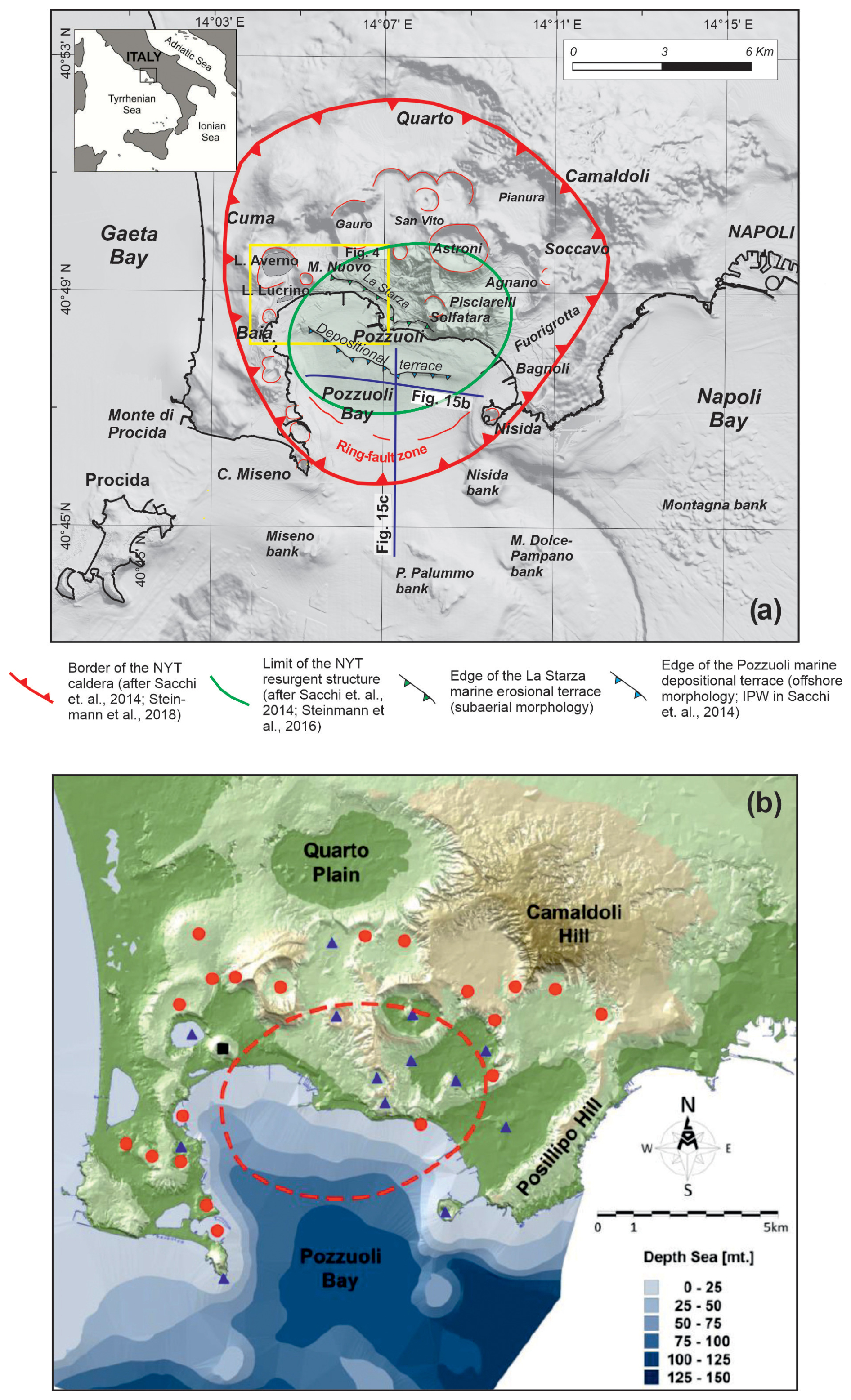
Figure 1(a) Location map of the study area with indication of relevant toponyms and major volcano-tectonic and morphostructural lineaments associated with the Campi Flegrei caldera. (b) Map of Campi Flegrei caldera. Red circles indicate the craters of the first post-caldera volcanic phase, and blue triangles indicate the craters of the second phase. The area within the red dashed circle represents the resurgent block of NYT that extends into Pozzuoli Bay.
The second post-caldera eruptive phase was preceded by an uplift of 30 m above sea level (a.s.l.) of La Starza marine terrace (Cinque et al., 1983; Rolandi et al., 2020b). The distribution of eruptive centres reveals that, during the first post-caldera phase, they were distributed around the resurgent block. In the second phase, among 13 volcanic edifices, seven occurred within the resurgent area (Fig. 1).
It seems likely that the second post-caldera phase (5.8–3.7 ka) can be considered the primary reference for defining possible future eruptive scenarios, following the eruption of 1538 CE.
3.1 Previous interpretations
Modern research on ground movements at the Campi Flegrei caldera started with the detailed studies by Parascandola (1943, 1947), the latter drawing mainly on earlier work by Niccolini (1846). The 1943 study primarily focused on historical documents describing the subsidence of the ancient Greek–Roman road known as “Via Herculea”, which was located near the Averno volcano and contributed to the formation of Lake Lucrino (Fig. 2).
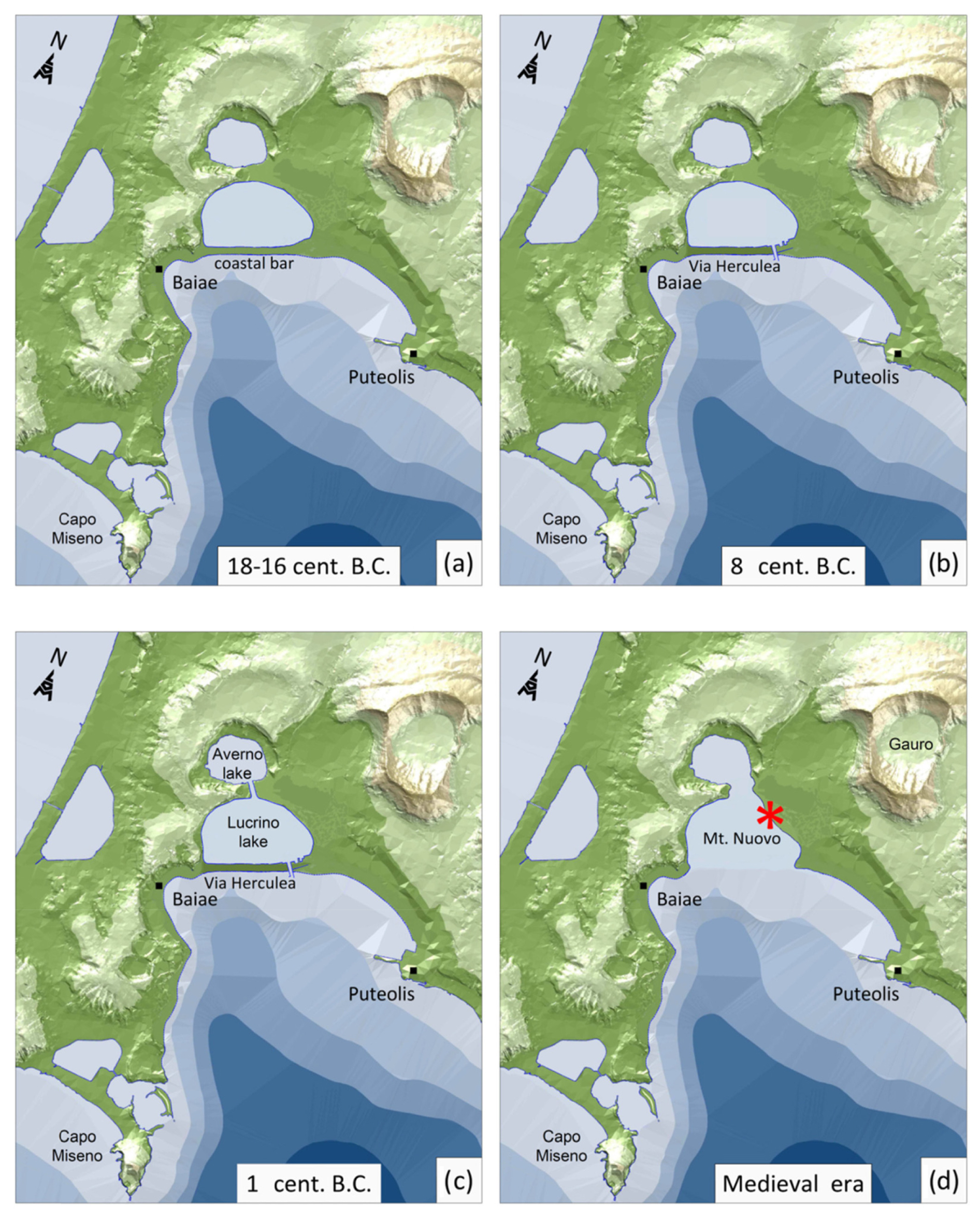
Figure 2(a–d) Position and shape of Via Herculea and the Lucrino and Averno lakes over 33 centuries. The red star indicates the central point around which the volcanic edifice of 1538 was formed.
Via Herculea, in use since Greek times (beginning in the 8th century BCE) and remaining important throughout Roman times, serves as a fundamental historical marker for assessing ground movements west of Pozzuoli. The detailed history of this road, reconstructed from numerous historical sources and included in the supplementary material, provides insights into its subsidence over the centuries.
The road ran along a narrow strip of land, probably formed by coastal aggradation of volcaniclastic sandy deposits (Parascandola, 1943) primarily from the 5 and 3.7 ka eruptions of the Averno and Capo Miseno volcanoes (Insinga et al., 2006; Di Vito et al., 2011; Sacchi et al., 2014; Di Girolamo et al., 1984). The deposits eventually created a lake, namely, Lucrino (Fig. 2a). Given its elevation just a few metres above sea level, subsidence significantly affected its usability, with frequent disruptions documented in historical records. These records provide crucial evidence of the evolution of ground subsidence in this area over the centuries.
The Greeks arriving from Euboea in the 8th century BCE initially settled on the island of Ischia (Pithecusa), before founding the “polis” of Cuma, the first Greek colony in Magna Graecia and the entire western Mediterranean. Since these times, the narrow land strip served as a road known as Via Herculea, providing access to the cultivated countryside around Pozzuoli (Fig. 2b).
Parascandola (1943) emphasised the continuous subsidence of Via Herculea, using historical accounts from Petrarca (1343–1361) and Boccaccio (1355–1373) to establish that the road had already sunk below sea level by their time. He also noted that Via Herculea did not re-emerge during the uplift accompanying the 1538 eruption, suggesting that the ground uplift in this area was insufficient to compensate for the secular subsidence.
In his later work, Parascandola (1947) presented a detailed reconstruction of ground movements in Pozzuoli, which has provided a common starting point for subsequent studies on this subject. According to Parascandola (1947), the maximum subsidence occurred during the 9th century.
The first paper to propose an alternative model for ground movements at Campi Flegrei was published by Dvorak and Mastrolorenzo (1991). They proposed simplified and constant rates of subsidence and uplift, suggesting that the maximum subsidence occurred at the end of the 15th century.
Morhange et al. (1999, 2006), based on radiocarbon dating of bivalve shells, identified an additional episode of ground uplift between 650 and 800 CE. Bellucci et al. (2006) later integrated the ground deformation model of Dvorak and Mastrolorenzo (1991) with the findings of Morhange et al. (1999, 2006) into a unified framework.
More recently, Di Vito et al. (2016) proposed a new reconstruction of ground movements, which will be discussed in more detail below. Their model suggests that the maximum subsidence occurred in 1251 CE. They also proposed that subsidence at Campi Flegrei began around 35 BCE and that the ground at the Monte Nuovo vent uplifted by approximately 19 m immediately before the 1538 eruption. The main reason for such different interpretations was the use of only partial datasets.
3.2 Reconstructing the ground movements with the entire available dataset
The inclusion of new historical documents allowed us to precisely reconstruct ground movements in the Pozzuoli area (central part of the caldera) and in the Averno area (3 km west of Pozzuoli, close to the area where the 1538 eruption occurred). The reconstruction reported here, based on all the reliable historical documents, hence allows us to tightly constrain past ground movements, thus resolving the differences in previous interpretations.
The first evidence of subsidence in the Campi Flegrei area dates back to Greek times, as reported by Diodoro Siculo (8th century BCE), and is related to the area in front of Averno lake, close to the vent of the 1538 eruption, which generated the Monte Nuovo cone. We will start to describe the historical documents to shed light on the ground movements in this area; then, we will reconstruct ground movements in the most deformed, central Pozzuoli area.
3.2.1 Ground movements at Averno
A fundamental historical marker for inferring the ground movements west of Pozzuoli, as already mentioned, is Via Herculea. Diodoro Siculo (see Appendix A) reported that, already at the time of the first Greek settlements, i.e. 8th century BCE, continuous subsidence affected this area, thus generating problems to the practicability of Via Herculea.
In Roman times, since the beginning of the 1st century BCE, the body of water enclosed by Via Herculea, purchased by Sergio Orata, has played an important role in fish farming since 90 BCE, taking the name Lucrino (from the Latin term “lucrum”, which means “for profit”), much larger than the present-day Lake Lucrino. After his death, continuous subsidence menaced both the practicability of Via Herculea and the fish-farming activities. The new owners, around 50 BCE, turned to the Roman Senate, calling for appropriate interventions. For this purpose, in the period 48–44 BCE, Julius Caesar was commissioned to build a barrier (Opus Pilarum) and special shutters to protect the road and Lucrino lake from sea ingression (see Appendix A). Towards the end of the same century, for military purposes, in 37 BCE, Agrippa cut both Via Herculea and the barrier with the crater of Averno. Having understood, unlike Julius Caesar, the continuous subsidence of Via Herculea, which at the end of the century was only a few metres above sea level (Fig. 2c), Agrippa also increased its height (Strabo, 1st century BCE). About 4 centuries later, Theodoric (King of the Ostrogoths), upon request for the protection of fish farming, restored the dam by increasing again the height of Via Herculea with respect to sea level (Parascandola, 1943).
Via Herculea finally sank below sea level between the 6th and 7th centuries CE, when the sea penetrated the crater of Averno, Lake Lucrino having disappeared (Fig. 2d). Proof of the disappearance of Via Herculea and of Lucrino lake was also testified by Boccaccio, who lived in the Naples area from 1327 to 1341 CE and described the Averno area in its geographical book “De montibus” (...to Averno, connected in ancient times with the nearby lake Lucrino where it recalls the waters of portus Iulius).
Via Herculea never rose above sea level again, despite the large uplift phase that occurred before and during the 1538 eruption (see Fig. 2d).
Our reconstruction of the level of Via Herculea, from the 8th century until 1538, is shown in Figs. 2 and 3. At the end of the 1st century BCE and 4th century CE, works were carried out to increase the height of the route above sea level due to the incipient submersion. Due to these works, the submersion of the route was delayed from about the 3rd century CE until the 7th century CE (Fig. 3). A date of submersion around the 6th–7th centuries is consistent with the observations by Parascandola (1943) that Via Herculea was above sea level for much of the 6th century.
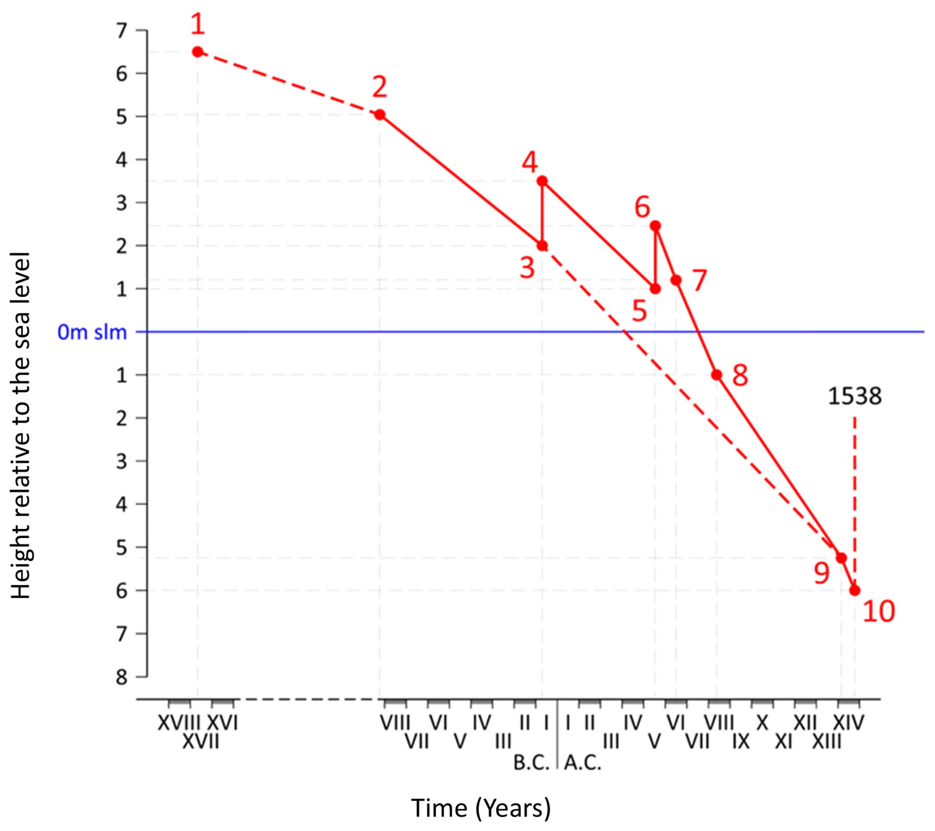
Figure 3Diagram showing the trend of ground movements at Via Herculea, with respect to sea level, over 33 centuries. Each point on the curve refers to a specific documented historical period, whose number indicates the reference for the inferred level. References are synthetically reported in Table 1 and extensively explained in Appendix A. Dashed lines represent hypothesised subsidences: the first one connecting to the likely initial elevation, the second one showing the likely subsidence path in the absence of the restoration works (points 4 and 6), and the third one showing the likely uplift linked to the 1538 eruption.
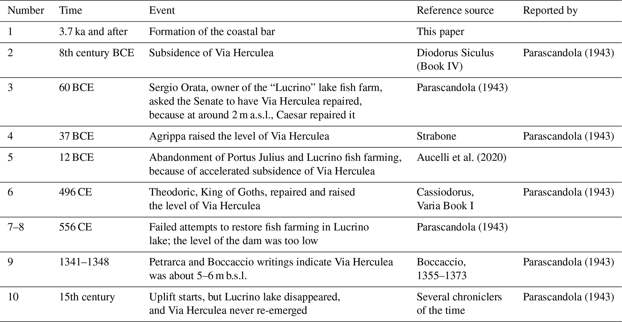
Table 1Illustrative sketch of the main historical sources used to reconstruct the ground deformations shown in Fig. 3 (see Appendix A for more details).
Via Herculea has remained submerged ever since (even during the 1538 eruption; Parascandola, 1943), and relics can be seen today about 4.5 m below sea level (b.s.l.) (Fig. 4).
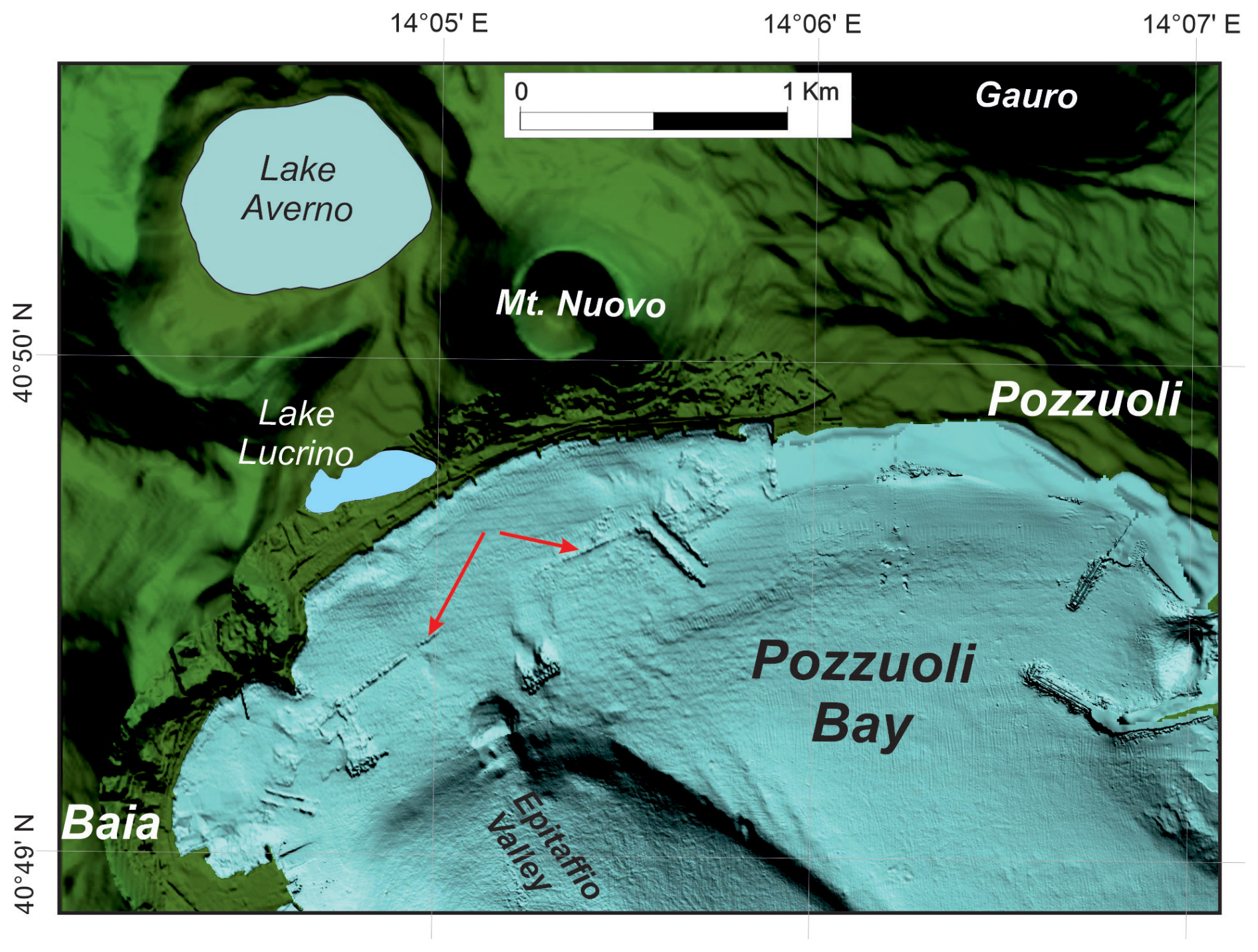
Figure 4Shaded relief map of the coastal area of Pozzuoli Bay based on high-resolution multibeam bathymetry (modified after Somma et al., 2016). Arrows indicate the submerged remains of the breakwater pilae of Via Herculea.
The submerged relicts of Via Herculea are still visible today, located at about 4.5 m b.s.l., as shown in the high-resolution bathymetry (Fig. 4; Somma et al., 2016).
3.2.2 Ground movements at Pozzuoli
While Via Herculea records the most ancient subsidence in the whole Campi Flegrei area, the best evidence for subsidence in the Pozzuoli area, where maximum ground movements have been recorded, comes from a Roman marketplace, Serapeo, although subsidence in the Pozzuoli area has also been testified since Greek times (Gauthier, 1912).
Recent drilling has revealed four successively superimposed floors, ranging from the Augustan age (31 BCE–14 CE) to that of the Severi (193–235 CE), indicating a progressive subsidence (Fig. 5; from Amato and Gialanella, 2013). Figure 6 shows the time evolution of the approximate level of the uppermost, fourth floor. It subsided below sea level in the 5th century (about 200 years after its construction during the Severi Age). By the time it had reached 3.6 m b.s.l. (around the 7th century CE), the sediments had covered the base of columns (which formed the so-called “fill”; Parascandola, 1947). Lithodomes colonised those parts of the columns near sea level (between 3.6 and 6.30 m b.s.l.; see the two red arrows in Fig. 7c), creating pitted bands about 2.7 m thick above the sedimentary layers. This process occurred until the 9th century CE, when the fourth floor was located at a depth of 6.3 m b.s.l. In the same period, ground subsidence caused thermal and rain waters to flood the Agnano plain, east of Pozzuoli, where they formed a new lake (Annecchino, 1931). This indicates a general persistence of subsidence in the Pozzuoli area (Fig. 7a; Appendix B), contradicting the conclusion by Morhange et al. (1999, 2006) that an uplift of several metres occurred in the 7th–8th centuries.
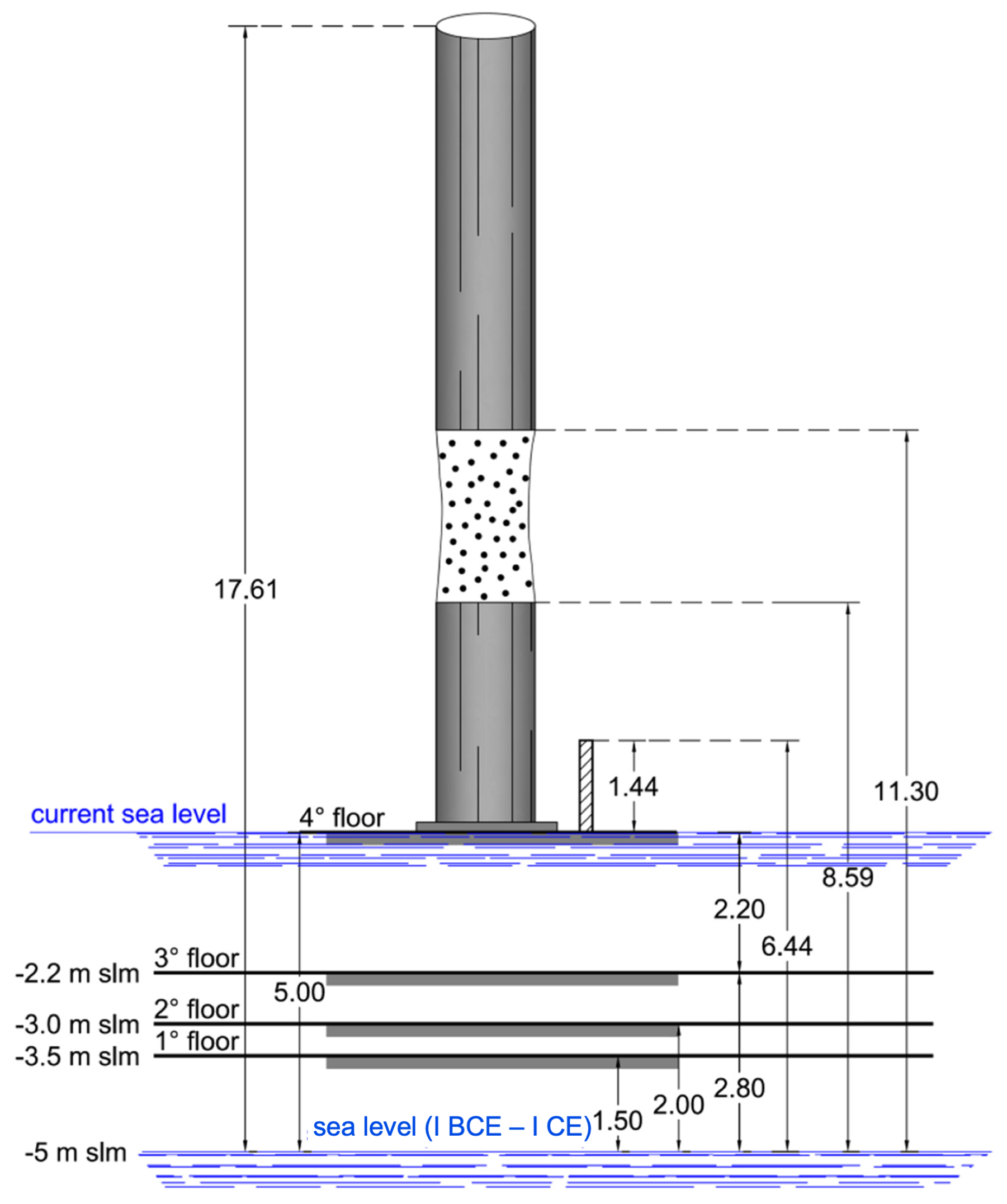
Figure 5Floors underlying columns of Serapeo (redrawn from Amato and Gialanella, 2013). The dotted part of the column indicates the boring due to colonies of Lithodomus lithophagus.
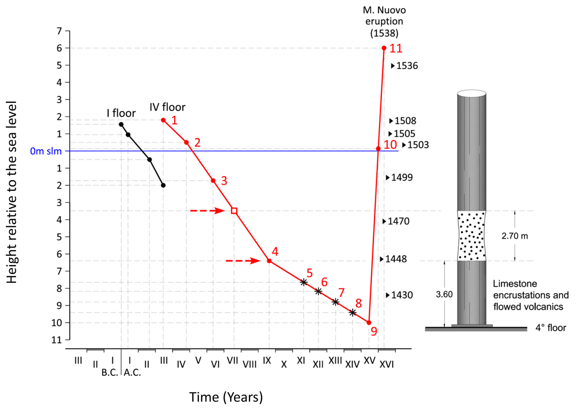
Figure 6Diagram of the level of the first (until the building of the fourth floor) and fourth floor of the Serapeo. The arrows indicate the limits of the submersion corresponding to the part of the columns bored by lithodomes. Each point on the curve refers to a specific documented historical period, whose number indicates the reference for the inferred level. References are synthetically reported in Table 2 and extensively explained in Appendix B. Dates marked on the right indicate the times of occurrence of major earthquakes.
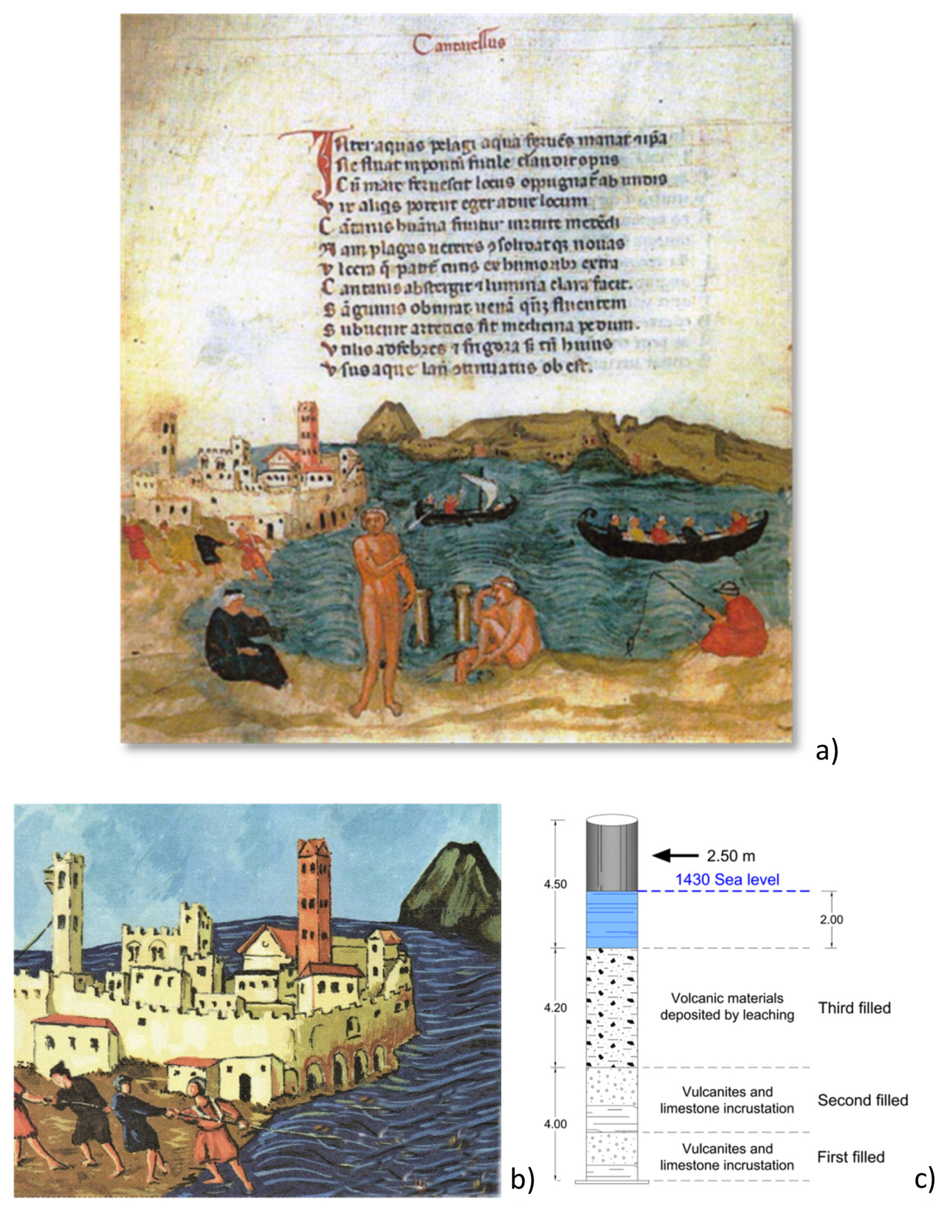
Figure 7Gouache of de Balneis Puteolanum from 1430 (after Di Bonito and Giamminelli, 1992): (a) stumps of the Serapeo columns that protrude from the sea to a height of 2–3 m, (b) fishing from the shore, highlighted in the box, indicates a draft depth of approximately 2 m of sea, and (c) reconstruction of the submerged, emerging and buried parts of the columns (see text for complete explanation).
Evidence for persistent subsidence comes from the Arab geographer Idrisi (11th century), from Benjamin ben Yonah de Tudela (12th century) and from Nicolò Jamsilla (13th century), who describe the morphology of Rione Terra as a medieval castle surrounded by the sea on three sides (Costa et al., 2022; see points 6 and 7 in Appendix B). Boccaccio (1355–1373) also reported that the fisherman's wharf in the Bay of Pozzuoli had become completely submerged (Parascandola, 1947; point 8 in Table 2 and Appendix B).
Table 2Illustrative sketch of the main historical sources used to reconstruct the ground deformations shown in Fig. 6 (see Historical Appendix B for more details).
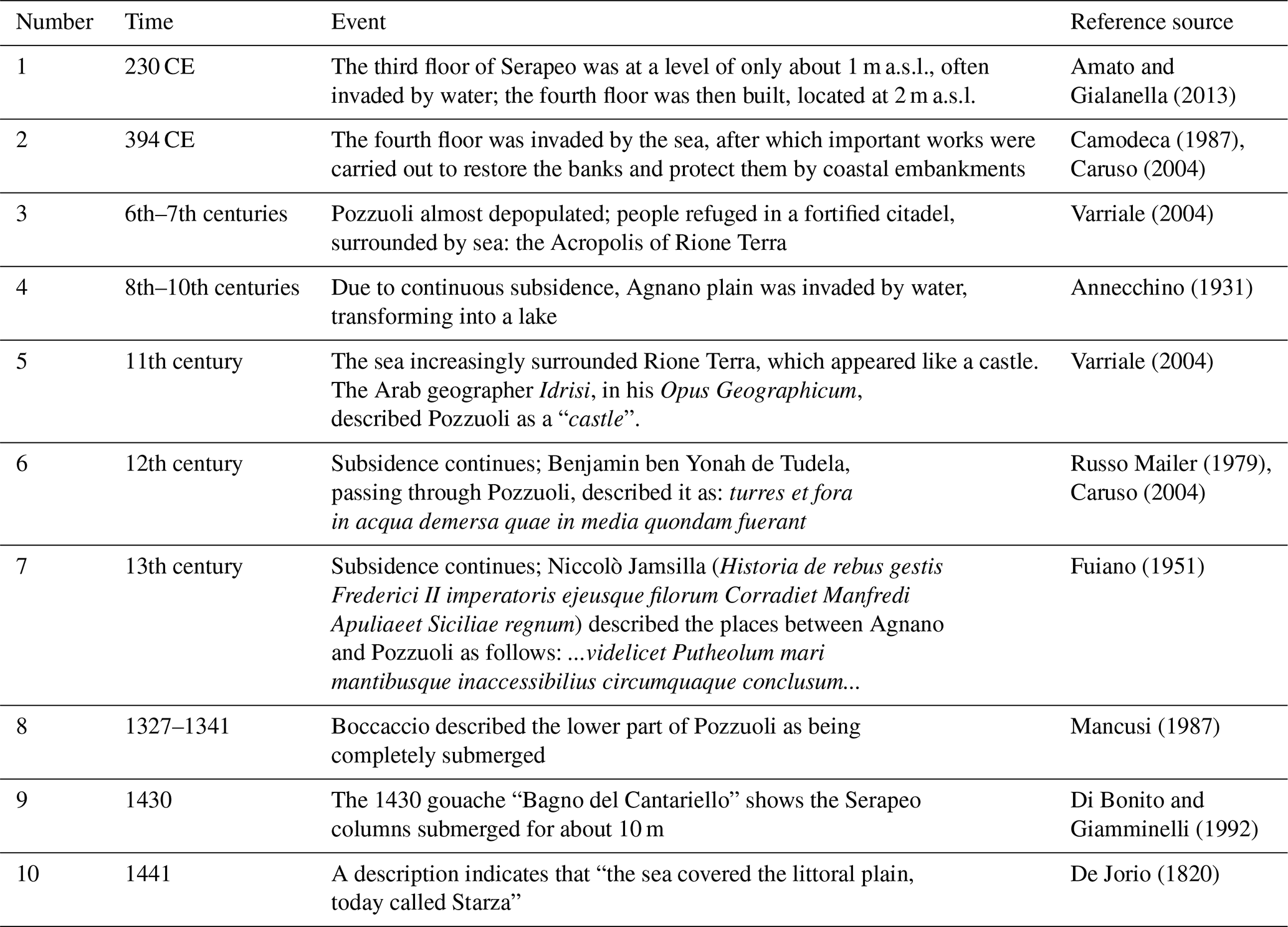
As already discussed by Bellucci et al. (2006), we can obtain a more precise estimate of the depth below sea level reached by the Serapeo's fourth floor in the 15th century by observing the painting “Bagno del Cantariello” (Fig. 7a), part of the famous De Balneis Puteolanis of the Edinburgh Codex of 1430 CE (Di Bonito and Giamminelli, 1992). The painting depicts the Rione Terra encircled by vertical yellow tuff walls, from which the beach of Marina Della Postierla extends (towards the observer) to the base of the San Francesco hill, the source of the thermal spring Cantariello (foreground) near the coast northeast of the submerged Serapeo. Behind the visitors of the thermal spring, the painting clearly shows the upper part of the three marble columns of the Serapeo above sea level. People are also shown fishing directly from the shore (Fig. 7b). From this painting, we can make a rough estimate of the portion of columns below the sea level at that time, taking into account that a significant part of the columns was submerged. Historical records from the 1750 excavations indicate that the buried part of the columns amounted to about 10 m (see Parascandola, 1947). The uppermost 2 m consisted of pyroclastic deposits of the 1538 eruption (see further paragraphs).
Before the eruption, therefore, the buried part of the columns must have been approximately 8 m. The presence of trawling fishermen (Fig. 7b) suggests a depth of the sea of not more than 2 m (the maximum water depth for this type of fishing not far from the beach). Given that the total height of the columns is 12.7 m, we estimate that the emerged part of the column in 1430 was around 2.0–3.0 m (Fig. 7a, c), as already computed in Bellucci et al. (2006). We therefore infer that in 1430 CE, the floor was about 10 m (± 1 m) b.s.l. (Fig. 6), which is consistent with a topographic map of the Pozzuoli area in Roman times (Fig. 8a; Soricelli, 2007).
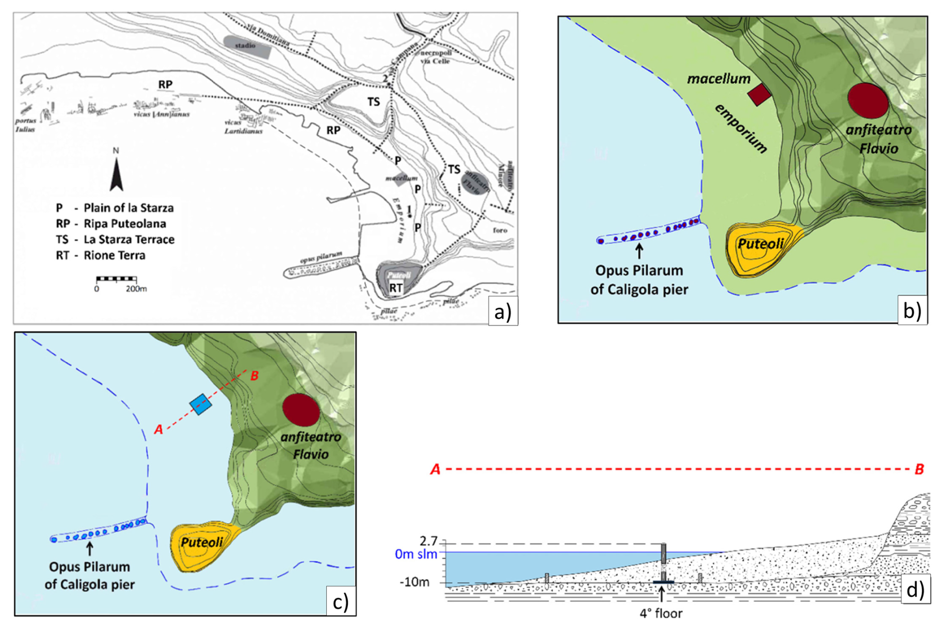
Figure 8(a) Map of Pozzuoli from the Roman era (3rd–4th centuries). The map shows the lower part of the emporium, which extends along the Puteolana bank (RP) until reaching the base of the hill, the so-called Starza plain (P) and the upper part of the Rione Terra cliff (RT), which, in turn, connects with the upper hilly part of the Starza terrace area (TS). (b) Part of the previous map, limited to the emporium area, in the Middle Age (after Aucelli et al., 2020; Taravera Montes, 2021). (c) The same area shown in b around 1430, during which the hill areas (TS, RT) were surrounded at the base by the sea, according to a description of the lower area of Pozzuoli from 1441: “the sea covered the littoral plain, today called Starza” (after De Jorio, 1820; Dvorak and Mastrolorenzo, 1991). (d) Sketch of the profile A–B shown in panel (c): the sea extended behind the Serapeo on the plain of La Starza hill, intersecting the columns at a height of 10 m (also shown).
The map (contour lines of 5 m) shows that in the period of greatest development, the city included the Greek Acropolis (the ancient Dicearchia, nowadays called Rione Terra), with a maximum height of 40 m a.s.l., the lower part of the city, i.e. the western area overlooking the Serapeo, and the upper city on the Starza terrace, with elevations between 30 and 50 m a.s.l. The latter was the site of major public works, such as an amphitheatre, stadium, forum and necropolis. From this map, a sketch of topographical relief above sea level (in Roman times, Fig. 8b) and below sea level (in 1430 CE, Fig. 8c) has been obtained as follows: from profile A–B (Fig. 8c, d), the fourth floor of the Serapeo can be located at 10 m b.s.l., packed in the sediments that form the Puteolana bank (RP), with the columns protruding from the same sediments for 4.5 m, of which approximately 2 m are sea water. Sea level intersects the columns at a height of approximately 10 m, connecting with the contour line of 10 m on La Starza plain (P) (Fig. 8c, d).
Figure 8c also highlights the morphological conditions of the Rione Terra, which, as we have already observed, has been described by the chroniclers who visited this place from the 11th to the 13th century as “an unapproachable mountain completely surrounded by the sea” (Fuiano, 1951; Varriale, 2004, in Appendix B).
The historical data presented here indicate several differences from previous reconstructions of ground movements in the area very different from the hypotheses that appeared in previous literature. One of the most recent works on such an argument (Di Vito et al., 2016), for instance, made the following claims:
-
the subsidence in the area started in 35 BCE;
-
the local uplift in the area of the 1538 vent, from 1536 to 1538, amounted to about 19 m;
-
the maximum subsidence was reached in 1251.
The first claim is in contrast with historical evidence that Via Herculea showed signs of subsidence already at the times of Greek colonisation (end of the 8th century BCE; see Diodoro Siculo in Appendix A) (Fig. 2); in addition, Julius Caesar himself was sent by the Roman Senate in 48 BCE to fix the problem, which was provisionally best resolved by Agrippa in 37 BCE, raising the surface of Via Herculea with respect to sea level (see again the detailed explanation in Appendix A).
The second claim is unrealistic because an uplift in the Monte Nuovo area higher than a few metres would have raised Via Herculea above sea level (Fig. 3d), which did not occur.
Finally, claim 3 is not confirmed by the testimonies collected until 1430, which instead indicate that subsidence continued beyond 1251, until 1430 at least (Di Bonito and Giamminelli, 1992; Bellucci et al., 2006).
Our findings date the starting phase of uplift to around 1430, consistent with the interpretations of Dvorak and Mastrolorenzo (1991) and Bellucci et al. (2006). They are supported by the documented occurrence of the first powerful earthquake documented in 1448 (Colletta, 1988; see also the next paragraph), which induced King Ferdinand I of Aragon to suspend the so-called “fuocatico” (a medieval tax collected for each fire lit by a family unit; see Colletta, 1988). We know, from recent unrest, that earthquakes occur only during uplift at Campi Flegrei (Troise et al., 2019). It is also well known that, between 1503 and 1511, the municipality of Pozzuoli granted to citizens the new land that emerged as a result of the increasingly “drying up sea” (Fig. 9) (Parascandola, 1947).
Figure 9The uprise of the land (marked by the two arrows on the sides) was observed and described by Loffredo Ferrante in 1530: “the sea was very close to the plain which was at the foot of the Starza hill” (Parascandola, 1947). In this context, the fourth floor of the Serapeo had reached a height of approximately 4 m a.s.l.
The next important question is then the following: was the fourth floor of the Serapeo above sea level as early as at the beginning of the 16th century? Parascandola (1947) answered this question through a sentence found in an account by Loffredo Ferrante: In 1503, the sea was very close to the plain which was at the foot of the Starza hill (Fig. 8). So, it can be deduced that the floor of the Serapeo was just above sea level in 1503, that is, it had risen about 10 m in about 73 years, at a rate of 136 mm yr−1. There is clear evidence that the uplift phase continued until 1538, when the eruption occurred. The maximum uplift occurred in the Pozzuoli area, close to the Rione Terra cliff, and had reached up to 5–6 m a.s.l. by 1538 (Fig. 6).
At Averno, to the west, uplift was unable to raise Via Herculea above sea level. At Nisida island, to the east of Pozzuoli, the pier did not emerge above sea level (Parascandola, 1947). Hence, it is likely that the uplift phase had a bell-shaped trend, very similar to what we have seen in the recent unrest. Local large uplift occurred at the future site of Monte Nuovo just before eruption (around 48 h before), indicating the rising of the dyke, feeding the eruption. However, the total uplift there could not have been larger than about 7 m (the approximate depth b.s.l. of Via Herculea at the time).
The period between the end of the 16th century and the beginning of the 17th century lacks written documentation about ground movements at Pozzuoli. It is likely that subsidence started after the eruption. Contemporary paintings provide constraints on when subsidence began. The earliest, by Cartaro in 1584 (Fig. 10a), shows the Rione Terra in the foreground, with the Neronian pier almost completely above sea level, which means about 5–6 m.
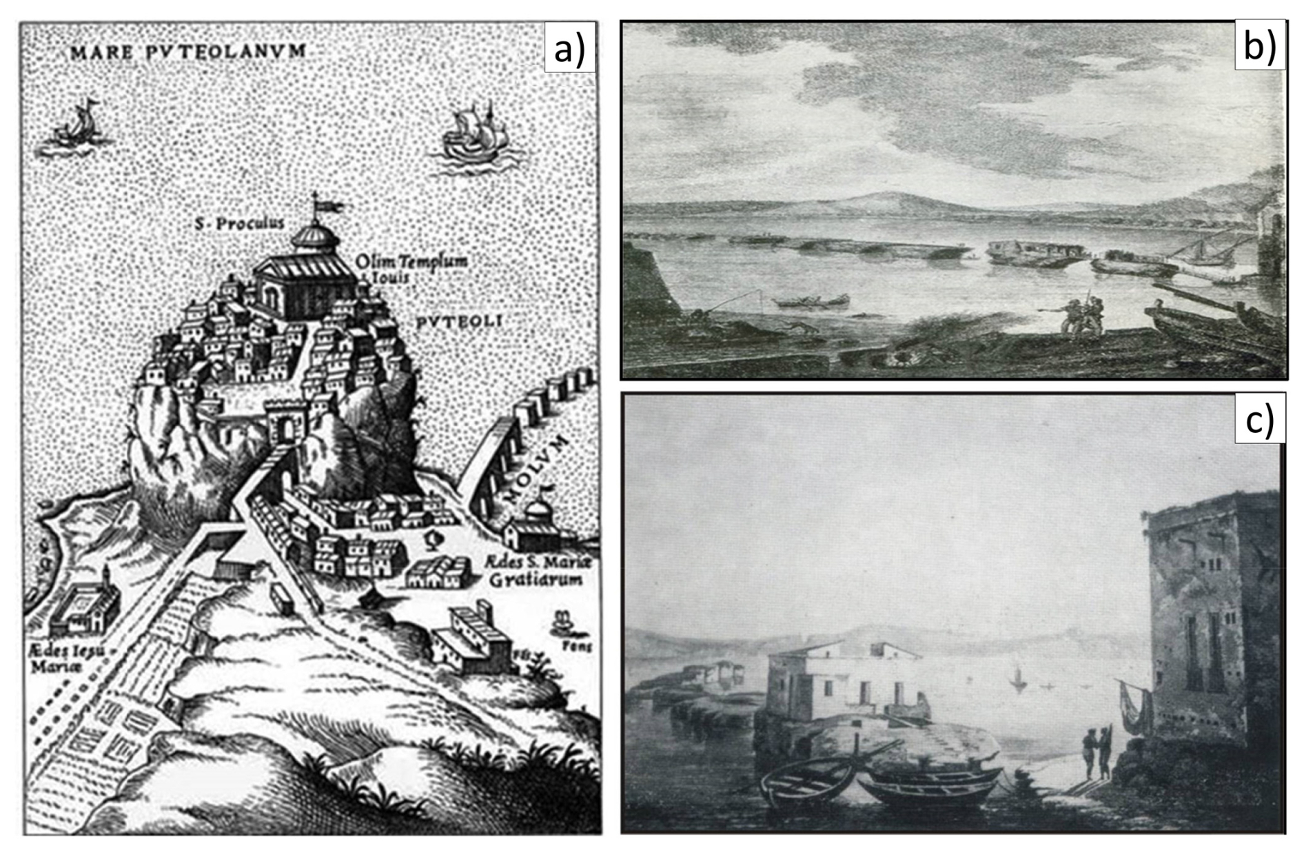
Figure 10(a) Engraving by Cartaro (1584) showing the Neronian pier at the base of the Rione Terra, emerging from the sea by 5–6 m, showing 10 of the 15 piles of which it was made up in the Roman epoch. (b) The remains of the pier piles, without the upper arches, highlighted in an engraving of 1750 (Maiuri, 1927). (c) Details of the same piles highlighted in another engraving from the same period (mid-18th century), where the height of the 1–2 m piles is observed in more detail, subject to marked erosion (Maiuri, 1927).
The pier also still appears partially complete, with about half of the pylons still connected by arches (Opus Pilarum). In comparison, paintings from the middle of the 18th century (Fig. 10b, c) show the pier completely destroyed and almost submerged. The painting in Fig. 10c shows the pylons in more detail, allowing their height to be estimated at 1–2 m a.s.l. Figure 11, from Hamilton (1776), shows similar ruins for the Neronian pier; hence, it appears that the pier subsided by 5–6 m from 1580 to 1776. Figure 11 also indicates that the floor of the Serapeo was almost at the same level as the pier in 1776.
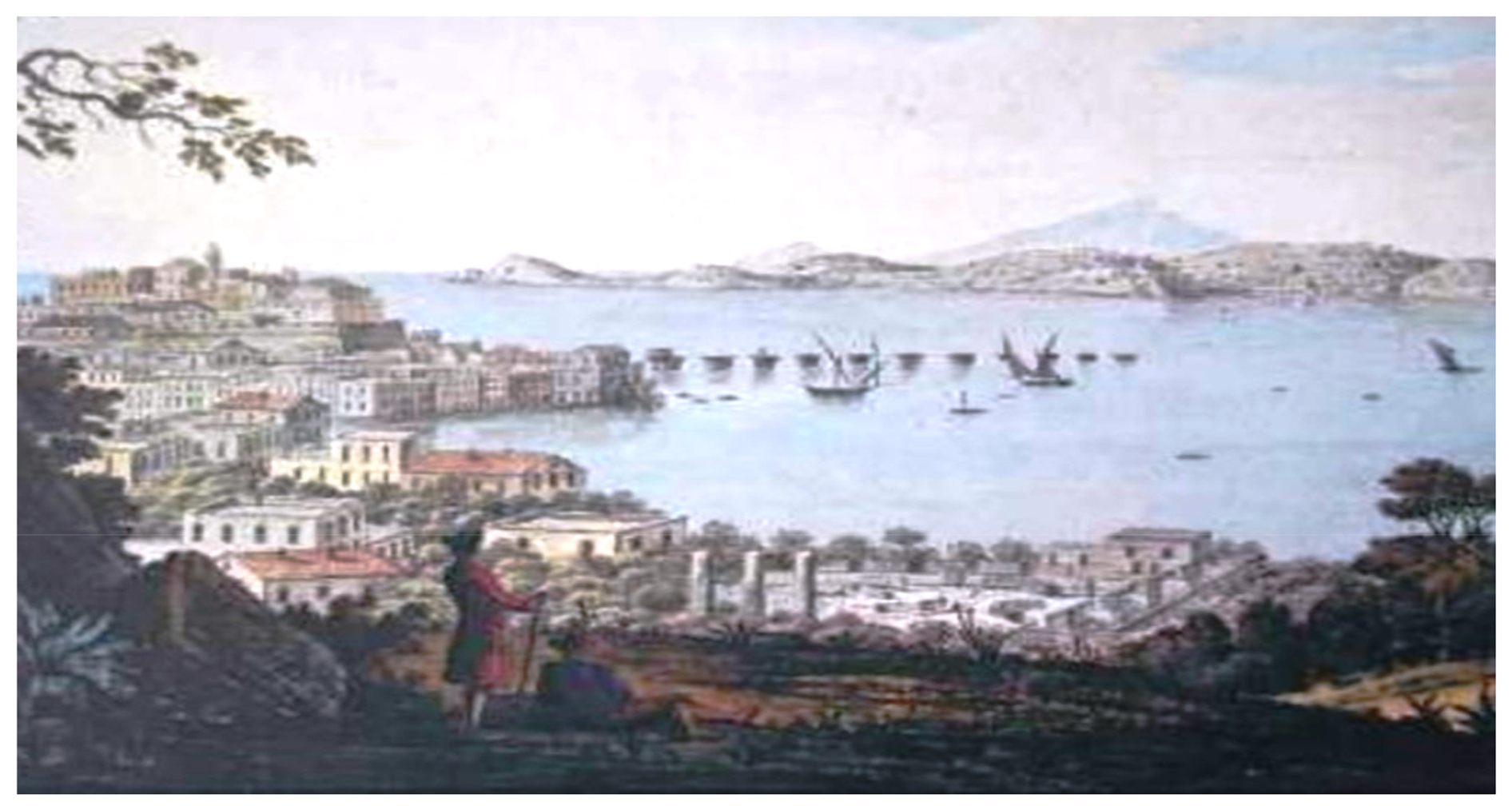
Figure 11View of the Gulf of Pozzuoli and the Cape Miseno peninsula (Hamilton, 1776). Both the remains of the Neronian pier and the newly excavated Serapeo are also visible.
Its level in 1538 can therefore be estimated at 5–6 m a.s.l. (Fig. 6), and about 1 m a.s.l. in 1750, with an estimated subsidence in 1580–1750 of about 4–5 m. This estimate is consistent with measurements by Niccolini (1846; reported by Parascandola, 1947), who found the fourth floor of Serapeo to have a height above sea level varying in the range 0.9–0.6 m throughout the 18th century. During the excavations of 1750 (Fig. 12), the floor could have hence been approximately at 0.7 m a.s.l.
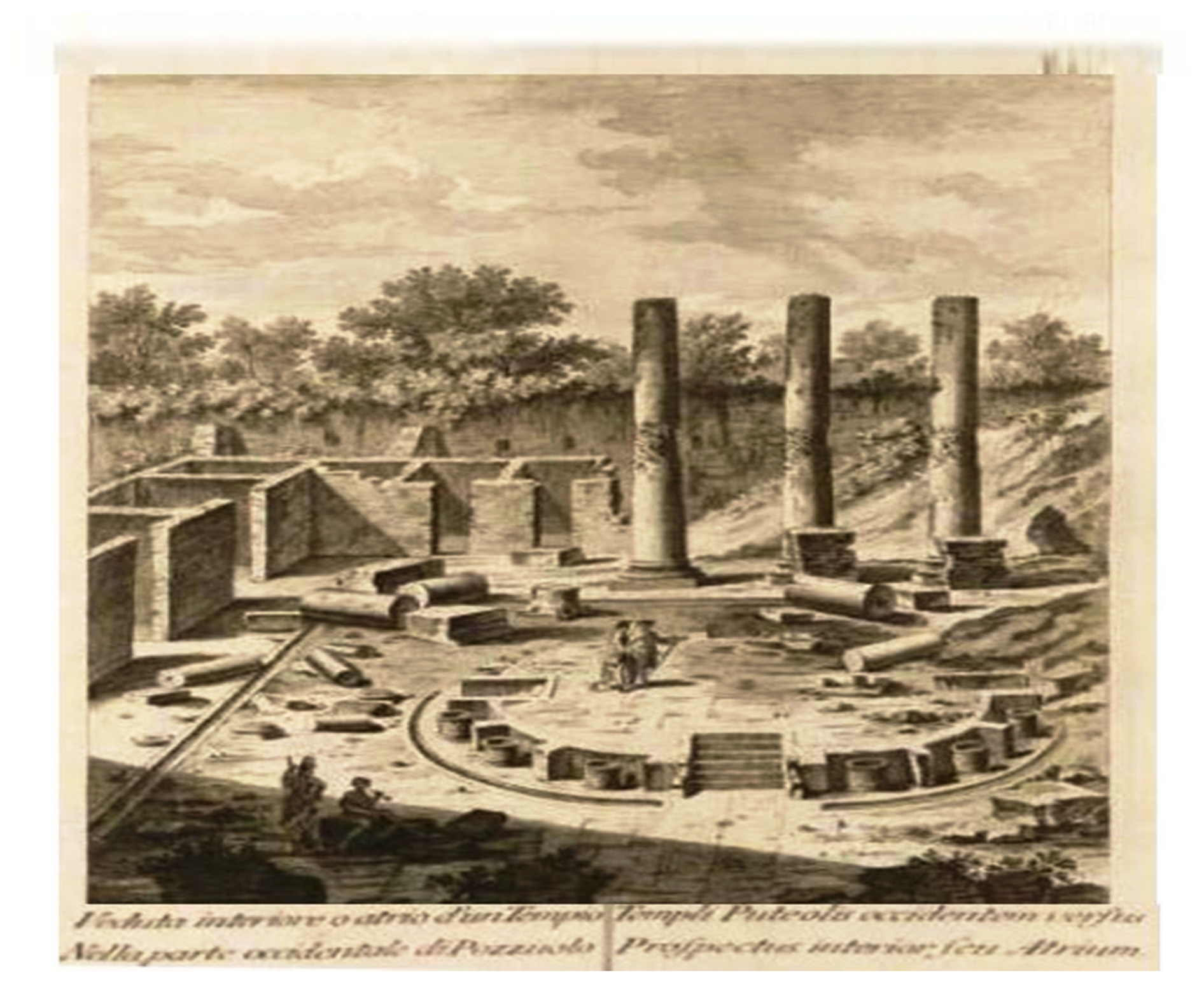
Figure 12Illustration of Serapeo, as excavated in the 3-year period 1750–1753. It can be noted that the height of the lighter parts of the columns, including the pitted band of the lithodomes, is preserved by oxidation, as it was packed by the just removed sediments. The darker upper part, oxidised since staying outside the cover, has a height of approximately 2.50 m, estimated in the same figure. This leads us to consider that the pack of sediments removed had a thickness of approximately 10 m, that is, the height of the hill where the vineyard of the three columns was located before the excavation (Niccolini, 1846).
Because the Serapeo floor is at the same level as the Neronian pier (Fig. 11), elevated 5–6 m a.s.l. in 1584 (Fig. 10a), recalling it was 10 m b.s.l. in 1430 and the total uplift was 16 m, we deduce that significant subsidence did not start before 1580–1584. Parascandola (1947) hypothesised that the subsidence of 4–5 m, which started after 1580, could have evolved at a higher initial rate such that, around the middle of the 17th century, it already had a value of 2–3 m, subsequently slowing down towards the end of the century until 1750. This likely hypothesis has been taken into account in the reconstruction of Fig. 13.
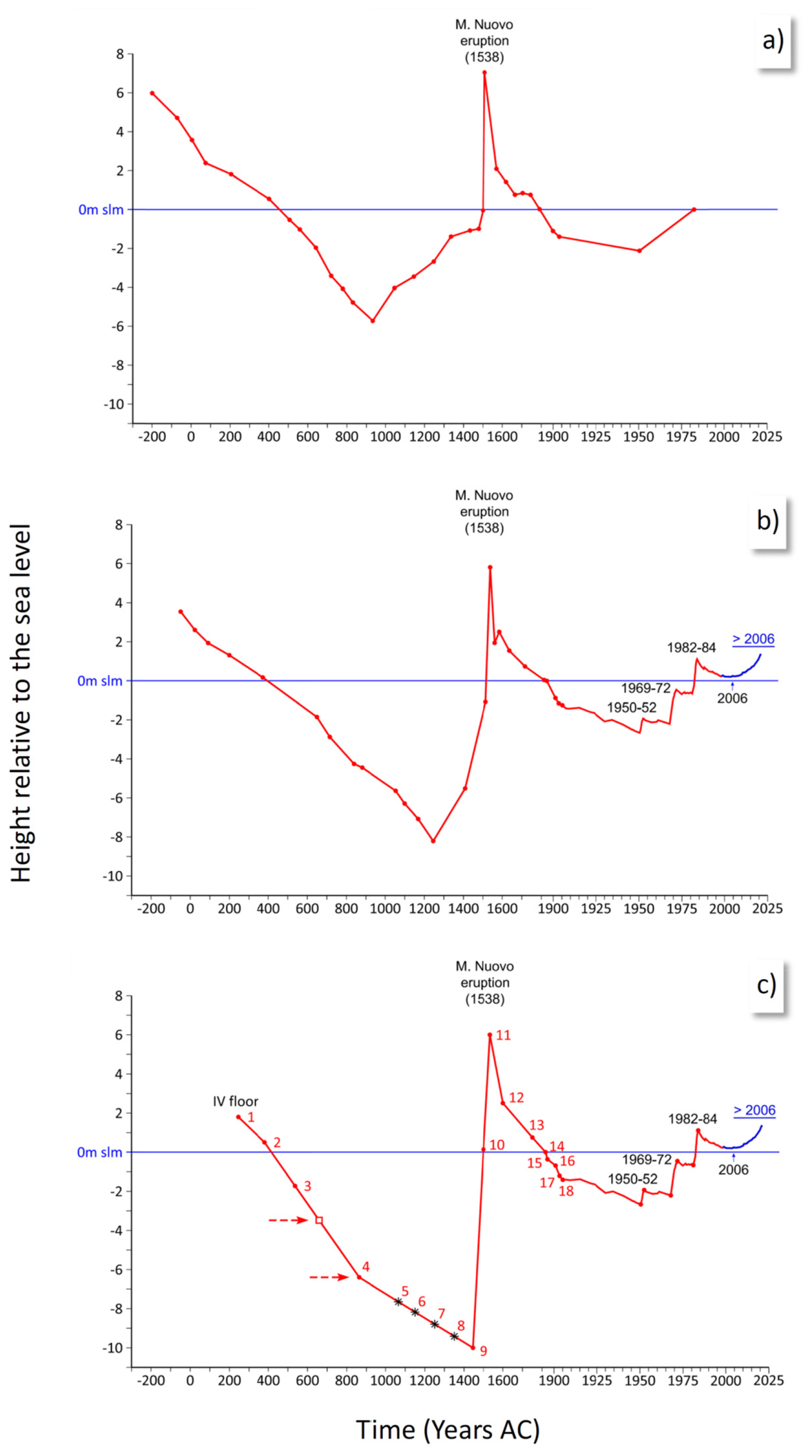
Figure 13(a) Reconstruction of the ground level of the Serapeo floor, with respect to the mean sea level (blue line), as proposed by Parascandola (1947). (b) Reconstruction of the Serapeo floor ground level, recently proposed by Di Vito et al. (2016). (c) Reconstruction of the ground level of the Serapeo fourth floor, from the 3rd century CE to the present, inferred by this study. Each point in the diagram corresponds to an appropriate historical indication reported in Table 1 and Appendix B.
It is also interesting to compare the average subsidence rate before 1430 with that observed between 1538 and 1950. The overall rate of subsidence after 1538 is more than 2 cm yr−1, almost double with respect to that observed before 1430. Actually, also excluding a likely first phase of sharp subsidence that occurred just after 1580, the subsidence rate observed before 1950 remains significantly higher than that observed since the Roman era until 1430.
Since the 1850s, survey data have recorded ground movements at Campi Flegrei with increasing precision. The Military Geographic Institute (IGM), in particular, started frequent high-precision levelling surveys in 1950. Data from the levelling surveys were still provided during the occurrence of the most recent unrest phases, i.e. in 1950–1952, 1969–1972, 1982–1984 and until 2001. Since 2001, continuous measurements have been provided by GPS stations, including station RITE installed at Rione Terra (Del Gaudio et al., 2010; see Fig. 13).
5.1 Dynamics of the resurgent block in response to temperature and pressure perturbations
Ground deformation at Campi Flegrei, before and after the 1538 eruption, appears to have been concentrated in a small area, a few km in radius, around Pozzuoli, similar to that observed during unrest since 1970 (De Natale et al., 1991, 2006; Troise et al., 2019). Such a concentration agrees with the presence of a resurgent block.
Evidence for resurgent block movement during unrest was first highlighted by De Natale and Pingue (1993), who pointed out that the concentration of the uplift in a small area, the high uplift values, and the invariance of the uplift and subsidence shape, as well as of the seismic area, were consistent with the up and down movement of a block bordered by ring faults (see also De Natale et al., 1997; Beauducel et al., 2004; Troise et al., 2003; Folch and Gottsmann, 2006). A resurgent block, mostly detached from the external caldera rocks, would also favour the almost constant, highly concentrated shape of ground displacement during both uplift and subsidence. Active high-resolution reflection seismic surveys have imaged the presence, in the Gulf of Pozzuoli, of an inner resurgent anti-formal structure or “block” bounded by a 1–2 km wide inward-dipping ring fault system associated with the caldera border, whose limits have also been documented by a survey (Sacchi et al., 2014; Steinmann et al., 2016; Sacchi et al., 2020a). Further constraints for the extent on-land of the resurgent block come from stratigraphic evidence. In particular, the old well CF-23, drilled in the Agnano area, presents about 900 m of NYT deposits, topped by only 100 m of more recent deposits (Rolandi et al., 2020b). The presence of uplifted, thick layers of NYT characterises the stratigraphy of all the wells contained in the resurgent block (Fig. 14a, b, e), thus allowing us to map its extent on-land, although only CF-23, by far the deepest one, clarifies the whole thickness of the NYT deposits in the resurgent area (Fig. 14a, c, d).
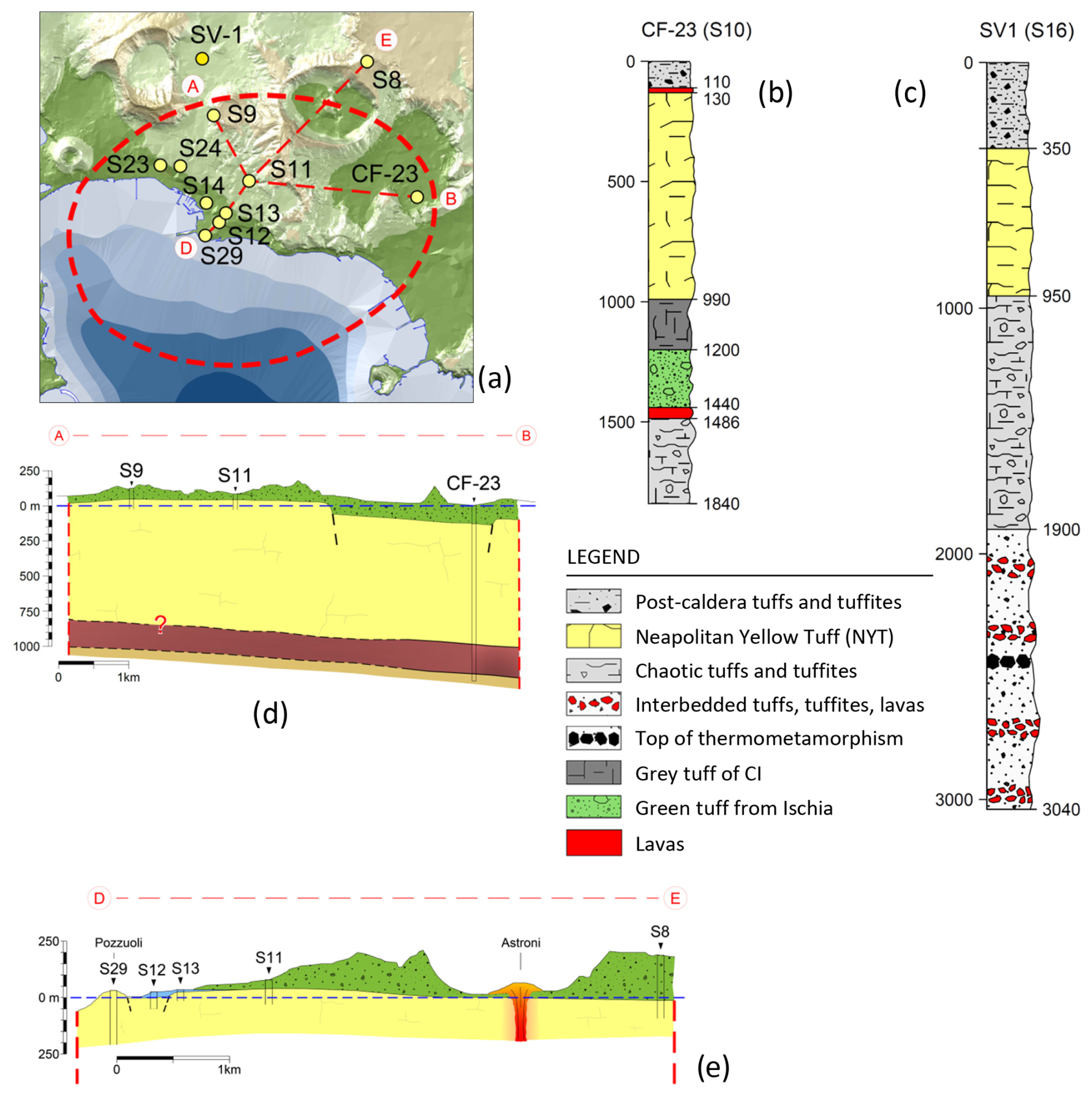
Figure 14(a) Location of the wells explored within the resurgent tuff block, as reported in the literature; (b) stratigraphy of the CF-23 (S10) well, within the resurgent block; (c) stratigraphy of the SV-1 well, outside the resurgent block, which highlights a stratigraphy where the NYT tuff blocks are not present with significant thicknesses; and (d–e) profiles in the resurgent block, which highlight the shallow depth of NYT because of the resurgence.
The extent of the resurgent block on-land appears also reasonably well defined by a clear relative gravimetric maximum (Capuano et al., 2013). The resurgent structure is also associated with distinct seismicity along the bordering ring fault zone (see also Troise et al., 2003). Figure 15a–c demonstrates how the resurgent block is well shown by passive seismic data (Fig. 15b, c) and by earthquake locations (Fig. 15a; see Troise et al., 2003).
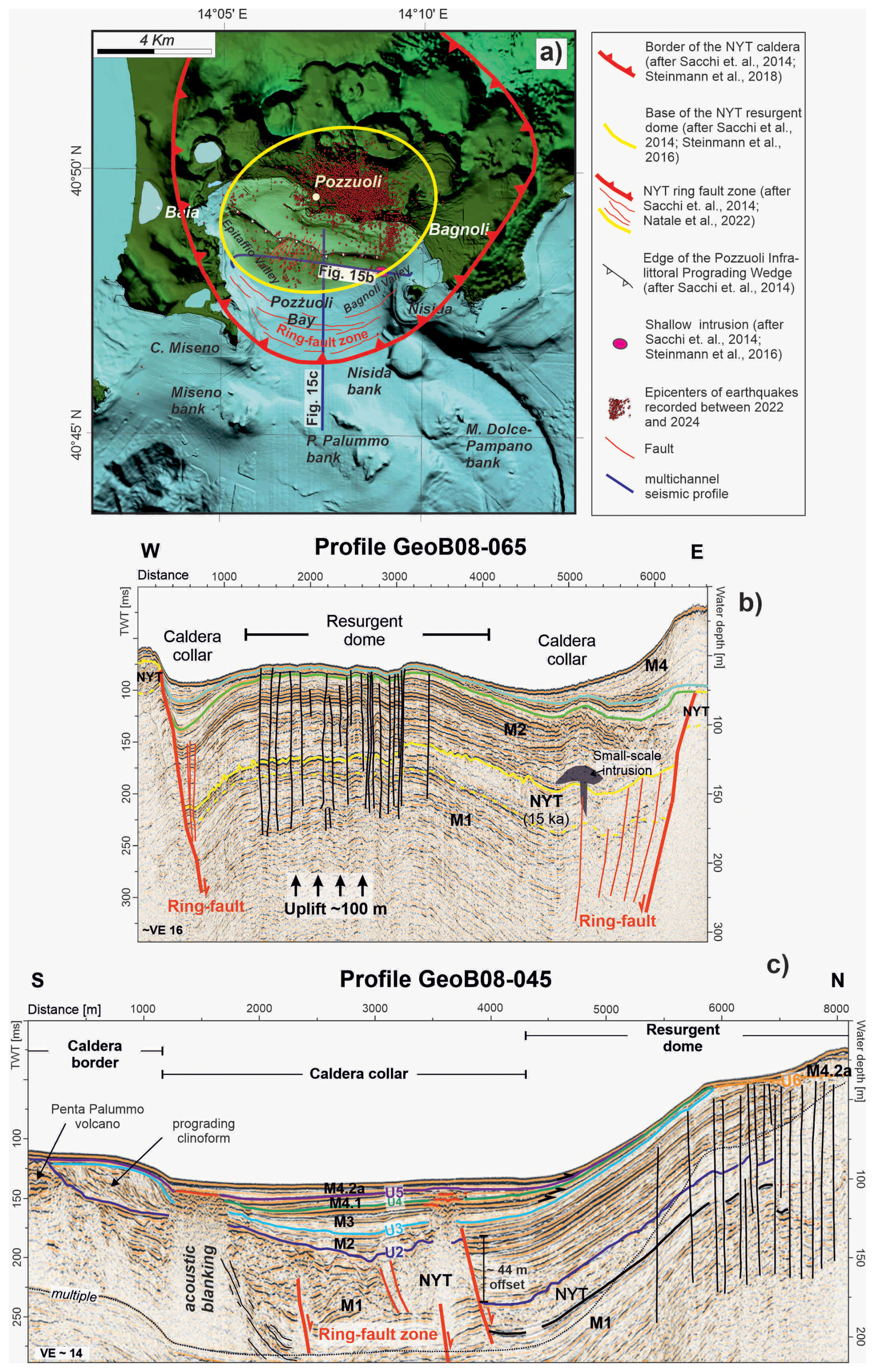
Figure 15(a) Campi Flegrei map showing the approximate limits of the resurgent block (area in the yellow ellipse), which concentrates the ground deformation and seismicity. (b) The N–S and (c) W–E profiles of the high-resolution seismic survey, showing the offshore signature of the NYT ring fault system and resurgent structure (modified after Sacchi et al., 2014, 2020a, b; Steinmann et al., 2016).
The presence of the central, resurgent block significantly affects the dynamical behaviour in response to temperature and pressure perturbations. This is particularly evident in the central, most deformed and seismic area, where the shallow crust involves approximately 1.5 km of lithoid tuff. This contradicts substructure models proposed by various authors (Rosi and Sbrana, 1987; Vanorio et al., 2002; Lima et al., 2021; Kilburn et al., 2023), which often assume a thick shallow layer of loose pyroclastics from recent eruptions, typically represented by the stratigraphy of well SV-1 (see Fig. 14e). We stress that deposits from recent eruptions are not lithoid in character because almost all of them, except very few, did not experience zeolithisation, which only occurs with high temperature and high water content (Cappelletti et al., 2015).
The physical state of the shallow structure within the resurgent block can be inferred by seismic tomography analyses presented by several authors (e.g. Aster and Mayer, 1988; Vanorio et al., 2005; Vinciguerra et al., 2006; Battaglia et al., 2008; Calò and Tramelli, 2018). These analyses consistently indicate a high ratio centred below Pozzuoli town down to 1–2 km, interpreted as highly water-saturated tuff.
Of particular significance is the work by Vinciguerra et al. (2006), which compared the results of seismic tomography with laboratory tests. They demonstrated that the tuffs present in the central area of the Campi Flegrei caldera can be either water- or gas-saturated and that inelastic pore collapse and cracking produced by mechanical and thermal stress can significantly alter the velocity properties of Campi Flegrei tuffs at depth. The effect on velocities becomes significant when the temperature rises sufficiently to induce physical changes, such as volume change and the generation of free water associated with the dehydration of zeolite phases. This can lead to thermal crack damage (see also Chiodini et al., 2015; Moretti et al., 2018), further affecting the dynamic behaviour of the area. At higher depths, well CF-23 indicates the presence of pyroclastic deposits from a depth of approximately 1.5 km to at least 1.8 km, where a temperature of 300 °C was measured (Fig. 14b). Likely, at even greater depths of about 3 km, marine silt and clay layers induce silica mineralisation and the formation of low-permeability horizons. Due to the high temperatures, estimated to be at least 400 °C, these layers undergo thermal alteration, forming a thermo-metamorphosed layer (Fournier, 1999; Lima et al., 2021; Cannatelli et al., 2020).
In addition, Battaglia et al. (2008) interpreted a low body, imaged to a depth of about 3–4 km, due to the presence of fractured, overpressured gas-bearing formations, confirming the data of Vanorio et al. (2005). This depth range of 3–4 km likely represents a primary accumulation zone for shallow intruded magma, which is unable to reach the surface and instead forms magma sills (Woo and Kilburn, 2010; Di Vito et al., 2016; Troise et al., 2019; Kilburn et al., 2023). The magma at this depth could be in a mush state, i.e. solidified but still at temperatures high enough to be remobilised by the inflow of new magma or hot magmatic fluids (De Natale et al., 2004).
At even greater depths, approximately between 7 and 8 km, the main magma chamber is located. This chamber contains both liquid magma and residual mush from past eruptions (Zollo et al., 2008).
5.2 The preparatory phases of the 1538 eruption
A tentative model can now be constructed for the preparatory phases of the 1538 eruption, which accounts for all available data. It is shown in Fig. 16 and can be summarised as follows.
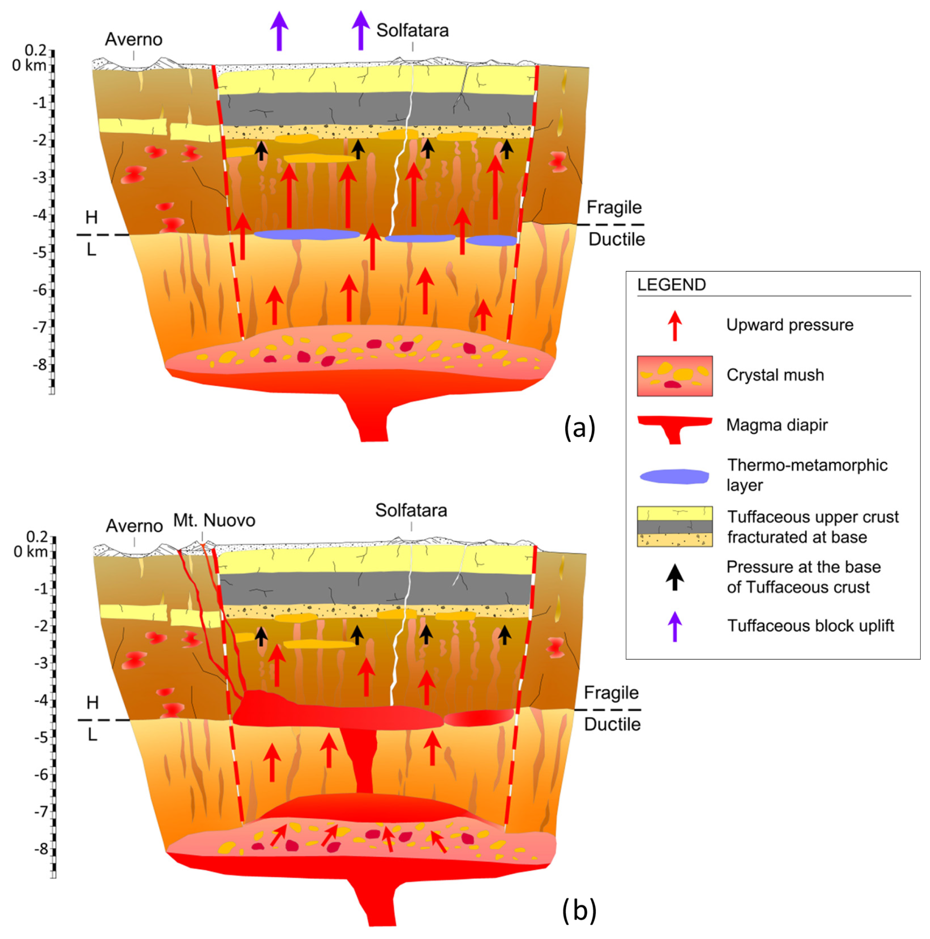
Figure 16Schematic cross sections of the hydrothermal and magmatic systems underlying the Campi Flegrei resurgent block in 1538 CE, showing: (a) the process of gas sparging according to the Bachmann and Bergantz (2006) model, related to the transfer of hot gas from a mafic intrusion underplating the trachytic mush and the hypothesised relation with earthquake swarms of the exsolved fluids, accumulated at lithostatic pressures in the ductile region and episodically injected into the brittle crust at very high strain rates. The sudden increase in fluid pressure, in the brittle region, can trigger earthquake swarms in the 2–4 km depth range. (b) Remobilisation of mush by mafic magmas then occurs, with the magma remobilised from the mush accumulates at the top, fuelling its rise upward to accumulate, in a sill-like shape, along the ductile-brittle transition surface. Eruption from the magma sill is then likely to occur at the faulted borders of the resurgent block.
The Pozzuoli area experienced a long period of subsidence, beginning at the end of the second phase of post-caldera volcanism (3.7 ka BP) and lasting until 1430 CE. This subsidence was likely triggered by the collapse of the upper and middle crustal blocks into the underlying magma chamber, situated deep within the limestone basement at depths of 7–8 km (Zollo et al., 2008). Any viscoelastic behaviour of the shell encasing the magma chamber may have also contributed to the subsidence, along with the decrease in magma volume due to cooling and crystallisation (Fig. 16a).
Since the end of the second phase of post-caldera volcanism, approximately 3.7 ky ago, the primary magma chamber, located at a depth of 7–8 km, likely contains a mixture of liquid magma and mush. It is important to note that mush refers to a non-eruptible phase of trachytic magma, composed of 25 % vol–55 % vol by crystals (Marsh, 1989; Bachmann and Huber, 2016; Cashman et al., 2017; Edmonds et al., 2019). When heated by several tens of degrees, typically through the injection of hotter magma, mush can revert to a liquid state, thereby regaining the ability to trigger a volcanic eruption (e.g. De Natale et al., 2004; Caricchi et al., 2014). However, the way the mush is rejuvenated by intrusion plays a fundamental role in this mechanism (Parmigiani et al., 2014). One plausible scenario is that the new magma from the deeper crustal levels forms sills at the base of the mush, revitalising it through the supply of heat, but not of magmatic mass, i.e. only exsolution occurs (Bachmann and Bergantz, 2006; Bergantz, 1989; Burgisser and Bergantz, 2011; Huber et al., 2011; Bachmann and Huber, 2016; Cashman et al., 2017; Carrara et al., 2020). The rapid uplift observed in the interval between 1430 and 1538 could be explained by the temperature contrast between the two layers: the mafic melt positioned at the base, being hotter than the overlaying layer, undergoes cooling and crystallisation, leading to an increase in the volatile content (primarily H2O and CO2) of the residual melt (Fig. 16b). Lower ductile rocks tend to deform gradually, allowing magmatic gases to permeate into the brittle zone above, thereby inducing a thermo-metamorphic separation layer.
A seismic anomaly displaying low at about 3–4 km depth (Battaglia et al., 2008) indicates the presence of supercritical fluids. Earthquakes are clustered above such a depth, as rock rheology is ductile at supercritical temperature, also suggesting the presence of both fractured rocks and overpressured gas. This condition likely results in triggering additional earthquakes (Fig. 16a); a similar condition has been often hypothesised to occur in the Yellowstone volcano (Shelly and Hurwitz, 2022) and is explained in the following. Intense degassing from the main magma chamber would lead to increased pressure in the shallow aquifers forming the large hydrothermal system, just as hypothesised for recent unrest (Moretti et al., 2017, 2018); moreover, the rise in temperature would cause the water contained in the tuffs' zeolites to convert into steam, generating additional overpressure. Such a situation is shown by the CF-23 well, where its stratigraphy indicates the presence of a magmatic layer approximately 30 m thick beneath the overlying tuff blocks, which are approximately 1.5 km thick (Fig. 14b).
It is noteworthy, when considering the correct stratigraphy of the resurgent block as represented by the CF-23 well, that some previous models suggesting the presence of two low-permeability layers at depth (Vanorio and Kanitpanyacharoen, 2015; Kilburn et al., 2023), inferred from the SV-1 well (which is situated outside the resurgent block) (Fig. 14a), can be questioned.
Finally, super-compressed magmatic gases were likely contained within an approximately 2.5 km thick fragile zone (from depths of about 1.5–2.0 to 4 km), while a limited release of the increased pressure occurred directly through the fractures connecting the intermediate depth area with the Solfatara and Pisciarelli areas, resulting in the escape of CO2-rich vapour. A similar mechanism has been evidenced in the recent unrest by the reported increase in fumarolic activity and in the ratio (Chiodini et al., 2021).
Following this hypothesis, it is noteworthy that, at a depth of 1.8 km, the CF-23 drill-hole indicates a very high temperature of 300 °C, not far from the supercritical temperature. It is plausible that, if the temperature significantly increases, due to the supply of deeper, hot magmatic fluids, the water contained in the basal part of the tuff block could reach supercritical conditions, leading to thermal fracturing within the tuff block (Vinciguerra et al., 2006) over a certain thickness (Fig. 16b).
As previously mentioned, the increase in pressure resulting from such intense heating caused by deeper magmatic fluids should be attributed to both the overpressure of shallow aquifers and the vaporisation of water contained in the zeolites, likely in the form of superheated steam.
The pressure increase in the main magma chamber, resulting from the input of new magma and/or magmatic fluids as explained, can also trigger the formation of magma dykes (Troise et al., 2019). The progressive intrusion of several magma dykes likely leads to the ascent of magma towards the surface. This process may be further facilitated by phreatic explosions caused by the heating of shallow aquifers, resulting in depressurisation pulses. Intruding magma may encounter layers that are more resistant to penetration at certain depths. In this case, further magma intrusion may be inhibited, and lateral expansion, to form sills, may occur (Gretener, 1969). Previous studies of recent unrest have indicated that depths between 2.5 and 4 km, close to the upper limit of the ductile zone, are locations where magma intrusions can halt (Woo and Kilburn, 2010; Troise et al., 2019). Before the 1538 eruption, a small plumbing system, in the form of flattened intrusions near the contact between a lower ductile zone and an upper brittle zone in a high-pressure environment, was hypothesised (Fig. 16b) (Pasquarè et al., 1988). From such a shallower magma chamber, magma can further progress upward towards the surface. A dynamic in which early intrusions in the shallow crust create small plumbing systems (i.e. stalled intrusions), from which a dyke later propagates, bringing a small quantity of magma to the surface, is typical of monogenic volcanoes (Martí et al., 2016). The ability of intruded magma sills to erupt at the surface is also influenced by the relatively short timescale of sill solidification, typically on the order of a few tens of years (Troise et al., 2019).
Shallow magma sills, in the form of mush, can be remobilised due to the arrival of new magma and/or hot deeper magma fluids. The significant uplift preceding the 1538 eruption, amounting to more than 16 m in the initial phase involving the entire resurgent block, if interpreted solely in terms of magma intrusion, would suggest a total intruded volume, in the shallow plumbing system, on the order of some cubic kilometres of magma (Bellucci et al., 2006).
However, despite such a large uplift, suggesting high volumes of shallow intruded magma, the eruption of 1538 produced only about 0.03 km3 of pyroclastic deposits (see the next section). This discrepancy likely suggests that multiple sill intrusions occurred over more than 1 century, with most of them solidifying without contributing to the eventual eruption. Only the most recent intrusion events, and/or some portion of magma mush from prior intrusions remobilised by subsequent heating, would have fed the eruption.
Also interesting is to note that, after the 1538 eruption, ground subsidence recovered only 8 m, i.e. one half of the former total ground uplift. This means that about one half of the total uplift may have been caused by thermally pressurised gas and water (shallow aquifers), perturbed by hot fluids coming from the deeper (7–8 km) magma chamber; the remaining, unrecovered uplift should have been caused by shallow magma intrusion. It is the same process hypothesised for recent unrest: in particular, the 1982–1984 uplift showed a subsequent subsidence about one half that of the former uplift, interpreted as the deflation of formerly pressurised water and gas (Troise et al., 2019).
Another characteristic of eruptions from small monogenic volcanoes is the difficulty in forecasting them, as they occur at unexpected locations (Martí et al., 2016). Both distinctive traits were evident in the eruption of Monte Nuovo, which represents a prototype of a small monogenic volcano in the Campi Flegrei. Despite the relatively small volume of magma (0.03 km3), the eruption occurred at a considerable distance, approximately 3 km westward, from the area of maximum uplift. The position of the 1538 vent is approximately on the border of the resurgent block; such a border, marked by ring faults, clearly represents a weak zone, where magma can more easily intrude.
5.3 The eruption of 1538
The week preceding the eruption was marked by a series of seismic events (Guidoboni and Ciuccarelli, 2011). The shoreline gradually retreated 200 steps (ca. 370 m) seaward because of an occasional uplift that occurred on the eastern shore of Lake Averno (see Fig. 2d), and during the 36 h preceding the eruption, the ground level reached 7 m of total uplift (Parascandola, 1943; Costa et al., 2022). The local uplift rapidly attenuated as a function of distance (Rolandi et al., 1985) (Fig. 6). The uplift, involving a local marine regression, was accompanied by strong rumbles on the night between 28 and 29 September, and culminated in a further explosion, at 02:00 on the following night, which marked the vent opening and the start of the eruption. The early eruptive column, initially white in colour, ejected muddy ashes and lithic and scoriaceous lapilli upwards. The presence of wet ash on the slopes of the gradually growing volcanic cone led Parascandola (1943) to hypothesise that it was a mud eruption. This description, present in the chronicles of the time (Parascandola, 1943), indicates that the first eruptive phase was phreatomagmatic in character, although it evolved with a peculiar characteristic, as the volcanic cone was formed by massive pyroclastic units, made up of loose and wet deposits, ascribable to pyroclastic flows products with a prevalent sandy matrix, incorporating lithic and scoriaceous clasts. In Fig. 17a, we recognise three main flow units, each of them made up of sub-units. These sub-units are mostly evident in the finest basal part (a), while in the intermediate part (b), showing an abundance of scoriaceous clasts, an inverse gradation is observed. Finally, the hydro-magmatic activity lasted about 12 h and built a small tuff cone, formed by successive waves of pyroclastic flow units, whose deposits reached a height of approximately 120 m. This particular type of hydro-magmatic deposit implies an eruption in which the magma–water interaction process is characterised by a low efficiency, considering the thermal energy of the magma and the mechanical energy generating the eruption. In the classic Wohletz experimental diagram (Wohletz, 1983), besides fields 1 and 3, which include, respectively, eruptions with a zero or low magma water ratio (0–0.1) and those with extremely high ratios (100–1000), field 2 includes hydro-magmatic explosive eruptions with an interaction ratio between 0.1 and 10, indicative of a greater value of mechanical efficiency (Fig. 18). It is evident, however, that even in field 2, there is a differentiation in efficiency due to the condition characterising the expansion of the water vapour that develops during the magma–water interaction process, that is:
-
If the magma water ratio is around a value of 0.3, the maximum efficiency is achieved. The quantity of water is optimal and expands entirely as superheated steam, that is, the maximum volume that can be generated is obtained without dispersing heat. Under this condition, the so-called base surges are formed.
-
If the water content increases, the efficiency drops because not all water is vaporised, and, as a result, steam saturated with water is formed. Under this condition, pyroclastic flows are formed.
This last type of flow is therefore associated with the collapsing eruptive column that developed in the night between 29 and 30 September, to be ascribed to a phreatomagmatic eruption with a high magma–water ratio, which gave rise to the non-welded ignimbrites described in typology 2 and located in the diagram of Fig. 18a at point a. Such particular condition for the flow, besides forming the new cone, also formed pyroclastic flows directed towards Pozzuoli. This kind of flow deposit, 5 m thick, is recognised in the tunnel of the new road to Arco Felice, located about 1 km from the cone (Fig. 18c). These deposits, never described before, also easily explain the 2 m of M. Nuovo eruption deposits described at the Temple of Serapis of Pozzuoli during the excavations (Parascandola, 1947) and formerly ascribed to fall products (Fig. 18b). This implies that in the initial phase of the eruption, the magma absorbed a considerable quantity of sea water present above the eruptive vent, so in these conditions, the collapsing eruptive columns, which gave rise to the pyroclastic flows on the night between 29 and 30 September, reached a maximum height of less than 3 km (Parascandola, 1943), depositing in a radius of approximately 3 km, as follows:
-
with a thickness of 5–10 m, in sections obtained by cutting the slope in the area around the volcano (Fig. 17a);
-
in a depression on the southeast sector of the volcano; the materials of the tuff cone of Monte Nuovo (T) are present, together with the products of the scoria flow (F) deposited in the southeast depression (Fig. 17b).
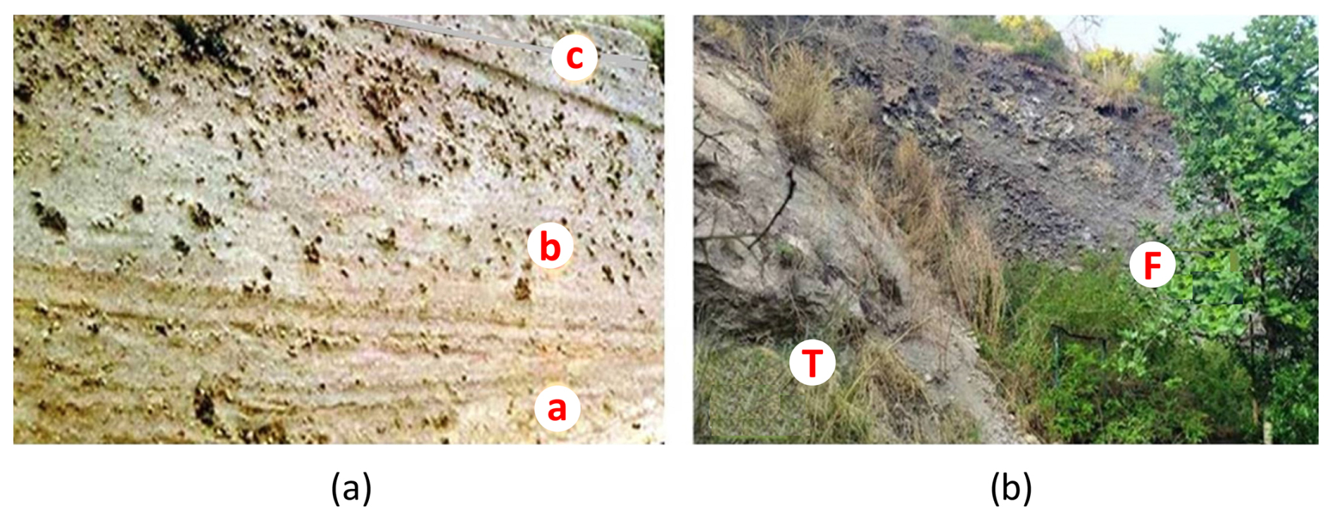
Figure 17(a) Flow units in the phreatomagmatic pyroclastic flows. (b) Deposit of the final scoria flow (F) in the western depression of the phreatomagmatic tuff cone (T).
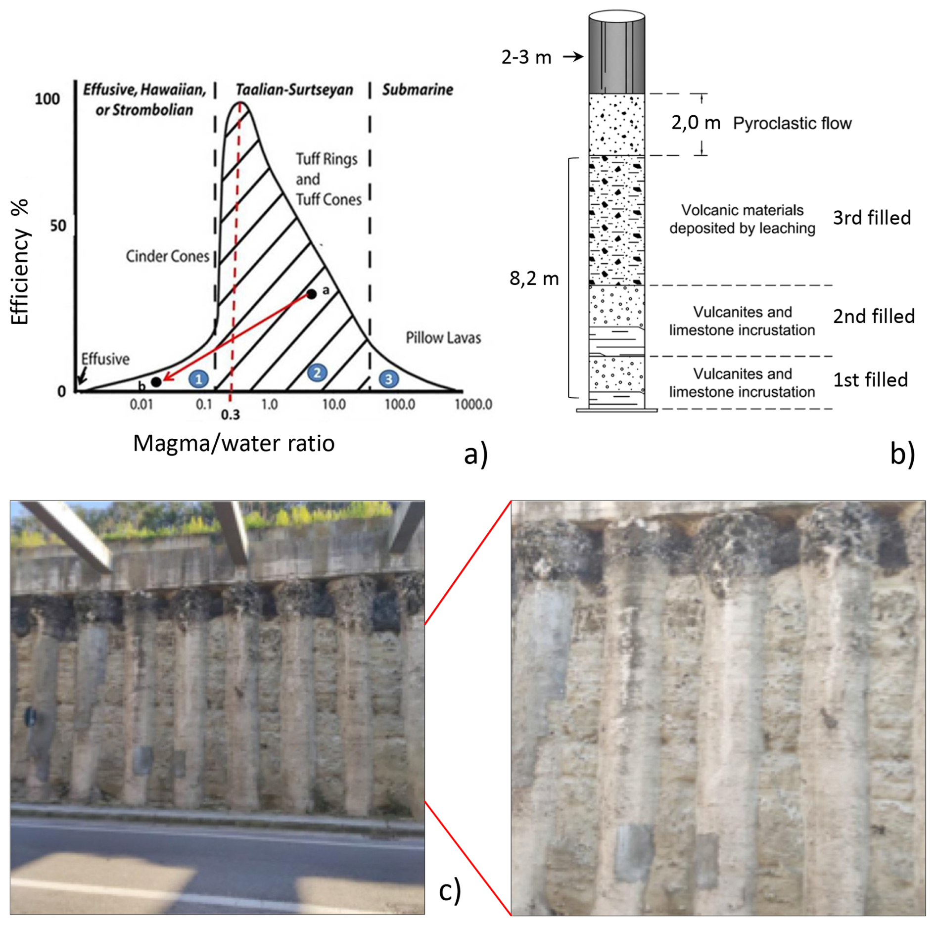
Figure 18(a) Wohletz (1983) diagram for the evaluation of the mechanical efficiency of the products emitted in the form of pyroclastic flows and fall/flow from Strombolian eruption column collapse; (b) products emitted by the 1538 eruption in the first eruptive phase as wet pyroclastic flow, which buried the upper part of the Serapeo columns (above a height of 8.2 m); and (c) deposits of pyroclastic flow directed towards Pozzuoli, showing a thickness of about 5 m, in the tunnel of the new road to Arco Felice.
According to the chronicles, on 6 October, there was a new eruptive phase, and 24 incautious visitors died, surprised by the resumption of eruptive activity, which revealed itself with different characteristics, mainly magmatic, that is, with a low water–magma interaction ratio (point b in Fig. 18a). In the hydro-magmatic to magmatic transition, the eruptive cloud took the characteristic “cauliflower” shape of Strombolian eruptions, with a height of about 4 km, which, driven by winds from the northwest and then from the north, distributed the scoriaceous products towards the southeast in the direction of Nisida and the Neapolitan coast, then towards the south in the direction of Bacoli and Capo Miseno (Parascandola, 1943). The scoriaceous products of the second Strombolian magmatic eruptive phase uniformly covered the basal units that formed the volcanic edifice during the first phase, with an average thickness of about 0.5 m. The final phase of the eruption occurred with the collapse of the Strombolian eruption column, which deposited a scoria flow in a depression on the eastern side of the underlying cone of materials formed by phreatomagmatic pyroclastic flow units (Fig. 17b). Overall, the eruptive event of 1538, with the emission of 0.03 km3 of pyroclastic material, can be classified with a VEI = 2.
The main precursors of the eruption, as reported by chronicles, were the earthquakes. Earthquake sequences preceded, accompanied and followed the 1538 event. In this context, seismic precursors may depend on the occurrence of stress perturbation, determined by the arrival of magmatic gases, as well as directly by magma intruded at shallow crustal levels (typically at depths of 3–4 km), originating from the main reservoir located at about 7.5–8.0 km in depth.
We analyse here the earthquake sequences that occurred before the eruption. Earthquake magnitudes, from inferred intensities of these earthquakes, have been computed as described in Appendix C. We can then compare past earthquakes with those that occurred during the recent unrest phases.
6.1 The seismic phases that accompanied the ground uplift and the eruption
We can classify the earthquake sequences into long-term, medium-term and short-term precursors.
-
The long-term seismic precursors started in 1448. Intense seismicity in 1468–1470 (Io = VII, Mercalli scale) (Guidoboni and Ciuccarelli, 2011; Francisconi et al., 2019) (Fig. 19a – interval A) culminated in vigorous fumarolic-hydrothermal activity at Solfatara, 2 km northeast of Pozzuoli, that caused widespread damage to the vegetation in surrounding areas. This may indicate a broadening of the area affected by intense degassing (Francisconi et al., 2019). Another seismic phase was reported in 1475 (Guidoboni, 2020), with a maximum intensity Io = IV–V, followed by accelerating ground uplift for the next 20 years. This period ended with a strong seismic phase in October 1498, reaching a maximum intensity Io = VII. Low-intensity seismicity then followed from 1499 to 1503 (maximum intensity Io = V) (Fig. 19a – interval A). Such a long-term precursory phase can be attributed mainly to degassing from the deep magma chamber increasing pressure in the shallow layers of the geothermal system, without requiring a significant contribution from magma intrusion at shallow depth.
-
Medium-term precursors emerged with seismic events in 1505 and 1508 of higher intensity than before (maximum intensity Io = VIII) (Guidoboni and Ciuccarelli, 2011). Faster ground uplift resulted in serious damage to buildings and caused several casualties. This seismic phase could have been caused by either a higher stress associated with increasing pressure and uplift or magma intrusion from the deep magma chamber into shallower levels. This intrusion could have produced higher stress, resulting in seismic activity of greater intensity. Although it is obviously difficult to identify, from historic sources alone, the respective roles of the deep degassing into the hydrothermal system versus shallow magma intrusion, we believe that the reported evidence of vegetation damage and increased degassing in the first phase and the increase in earthquake intensity in the second phase indicate respectively a main contribution of degassing perturbing the hydrothermal system (in the first phase) and of shallow magma intrusion (in the second phase). This phase ended in 1520 with a medium-intensity earthquake (Io = V–VI) (Fig. 19a – interval B).
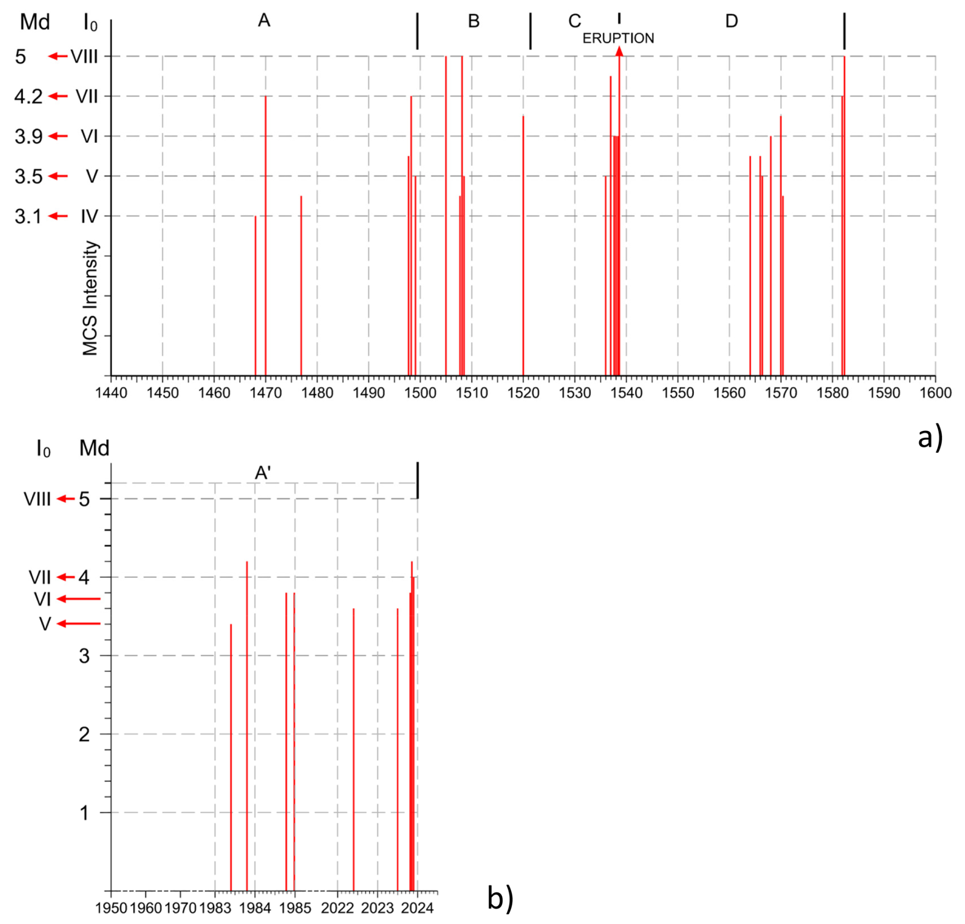
Figure 19(a) Reported earthquakes that occurred before and after the 1538 eruption (after Guidoboni and Ciuccarelli, 2011). The computed intensities of these earthquakes have been converted to magnitudes using the considerations made in Appendix C. (b) Highest-magnitude earthquakes (M ≥ 3.5) that have occurred since 1950.
After 16 years of relative seismic quiescence, possibly characterised by low-intensity earthquakes not reported in chronicles, a short-term precursory phase began in 1536. It started with continuous seismicity, without major damage (Io = III–IV), continuing with similar features until the early part of 1537. It is possible that this last seismic phase, characterised by relatively low magnitude, was caused by low-frequency seismicity, resulting from magma oscillations during the fractures' opening (see Chouet, 1996). This seismicity became more frequent right before the eruption. In February of the same year, the seismic activity peaked with stronger events (Io = VI–VII), accompanied by an increase in the fumarolic activity at Solfatara. This provides evidence that this seismicity could again be related to perturbations in the hydrothermal system. A final increase in seismic activity (Io = VIII) began in mid-June 1538, accompanied by a localised, significant additional ground uplift at the eruption site, located 3 km away from the centre of the previous maximum uplift (Fig. 19a – interval C) (Parascandola, 1943; Rolandi et al., 1985; Guidoboni and Ciuccarelli, 2011; Guidoboni, 2020).
6.2 The post-eruption seismicity
We will now consider the seismic phase following the eruption just described, which we will indicate as the aftereffect of the 1538 eruption. It began in 1564 with earthquakes of medium intensity (Io = V–VI), followed by a phase of lower intensity 2 years later. In 1570, seismic intensity increased (Io = VI–VII), causing damage to the buildings of the city of Pozzuoli. Between 1575 and 1580, a new phase of low seismic intensity began, culminating, in 1582, with two earthquakes, respectively of intensity Io = VII and VIII. These earthquakes caused partial collapses in several houses and serious damage to churches and buildings, as well as numerous casualties (Parascandola, 1943; Guidoboni and Ciuccarelli, 2011; Guidoboni, 2020).
Our reconstruction of historical ground movement and seismicity has identified features common to the medieval and present unrest. The main similarity is that the seismicity has been clearly correlated with both the total uplift and the uplift rate, and it is practically absent in periods of subsidence (Dvorak and Gasparini, 1991; Kilburn et al., 2017; Troise et al., 2019). We found, in particular, that seismicity of the period 1950–2024 is on the same order as that of the period 1430–1503, whereas the latter, as we have previously observed, was the first phase of preparation before the 1538 eruption. Although the ca. 10 m of total uplift in the period 1430–1503 was more than double the total uplift recorded since 1950–2024, about 4.3 m, the seismicity in the two periods is remarkably comparable. The maximum magnitude, M = 4.6, that recently occurred on 13 March 2025 is in fact very similar to the maximum magnitude reconstructed for the period 1430–1503 (Fig. 19a interval A and Fig. 19b interval A′).
It is also interesting to compare the average uplift rate before the 1538 eruption with that observed since 1950. In particular, we can compare the average uplift rate that occurred in the first 70–73 years, from 1430 to 1503, with that observed since 1950. In the period 1430–1503, the maximum ground uplift was about 10 m, thus implying an average uplift rate of about 13.5 cm yr−1; actually, the average ground uplift since 1950 has been less than half, at 6.1 cm yr−1, although from 1983 to 1984, it has been increasing by about 12–20 cm yr−1.
Another common feature is that both seismic phases, as well as ground uplift, can likely be ascribed to the effect of pressurised hydrothermal fluids (Moretti et al., 2017, 2018; Troise et al., 2019). So, until now, there is a close analogy between the “long-term precursory phase” preceding the 1538 eruption and the recent unrest of 1950–2023; the only clear difference is, as we already noted, the much lower cumulative uplift (and consequently average uplift rate) of the recent unrest.
Such observations led us to consider two possible scenarios for the evolution of the present unrest.
7.1 First scenario
The first scenario would imply that the present unrest progresses towards a new eruption. Although there is presently no evidence for shallow magma intrusions occurring during the present unrest since 2006 (see Moretti et al., 2017, 2018; Troise et al., 2019; Lima et al., 2024), a new shallow magma intrusion, in the near future, cannot be ruled out. Another possibility is that the mush, which should be present at low depth, could be re-mobilised by hot fluids coming from the main magma chamber, as we explained in the previous paragraphs. Troise et al. (2019) showed, in fact, evidence for a likely shallow magma intrusion that occurred at about 3 km in depth during the 1982–1984 unrest, with a volume of about 0.03 km3, i.e. the same order of magnitude of the erupted volume in the 1538 event. The same authors calculated, in agreement with other authors (Woo and Kilburn, 2010; Moretti et al., 2013; Moretti et al., 2018), that such a sill intrusion should have become like mush after about 20 years, i.e. around 2003. If the actual unrest progresses towards an eruption, it is also very likely that seismicity will increase in frequency and magnitude, possibly reaching magnitudes around 5 or even higher. Earthquakes of magnitude 5, in this area, would occur at very shallow depths (not higher than about 3 km), thus producing high intensities (higher than VIII on the MCS; see Fig. 19). Finally, from a civil protection perspective, we must also take into account the possible onset of a post-eruptive seismic phase, which, after the 1538 eruption, lasted more than about 40 years. In conjunction with the prefigured scenario, the problem of forecasting the position of a new eruptive vent is also extremely relevant because, in principle, it could open in any sector of the caldera. We believe that a reliable indication of the most likely future vent could come from the most seismic areas, as they reflect the areas of maximum shear stress. From this perspective, the Solfatara–Agnano area (see Fig. 15a), which is by far the most seismically active one, could be the most probable site for future vent opening. This area, which is also located on the main ring faults bordering the resurgent block, is, however, also indicated as one of the most likely by probabilistic studies (Alberico et al., 2011; Selva et al., 2011). Anyway, the most effective way to address this problem would be the prompt determination of localised uplift in addition to the usual bell-shaped one centred on Pozzuoli harbour. Although some recent eruptions (e.g. at Hekla volcano; Wunderman, 2000) show that the rise of magma from several km to the surface can occur so quickly that it can render civil protection efforts practically useless, localised and considerable ground uplift at the future eruptive vent was actually observed before the 1538 eruption, making it likely that this precursor will be observed before a future eruption in the area.
We must, however, consider the possibility that, even without new shallow magma intrusions, the increase in pressure for aquifer heating above the critical threshold could produce a phreatic eruption. Phreatic eruptions are in general very difficult to forecast and also to detect from the past geological record. However, there is some robust indication for at least one phreatic eruption that occurred in the area in 1198 (Scandone et al., 2010); it is also realistic that most of the phreatomagmatic eruptions in the area started as phreatic eruptions, as explained in previous paragraphs. The phreatic scenario deserves maximum attention for the current evolution of CF unrest because of its serious implications for civil defence purposes and for the even higher forecasting difficulty with respect to a magmatic eruption.
7.2 Second scenario
As an alternative scenario, we should consider the one that stops sometimes without evolving towards an eruption. Despite the similarity of the recent unrest with the first phase leading to the 1538 eruption, we could in fact consider the notable difference in the cumulative uplift between the past and present unrest phases in the first 73 years: 10 m from 1430 to 1503 compared with less than 4.5 m from 1950 to the present. The level of ground uplift is critical, as it indicates the level of stress accumulated underground. As pointed out by Kilburn et al. (2017), when the level of stress reaches a critical value, the medium rheology becomes totally fragile, and any small amount of incremental stress can cause the collapse (i.e. the catastrophic fracturing) of the shallow crust, thus producing an eruption. Actually, we do not know the critical stress level for the shallow crust at Campi Flegrei. The very high deformation that occurred before 1538, namely, 16 m plus the localised uplift that occurred just at the vent site before the eruption, seems to indicate that the critical stress level, at that time, may have been much higher than the one presently reached. So, if it could be assumed that the medium strength today is similar, there is a possibility that the progression towards eruption conditions is too gradual to culminate in an actual eruption, and the unrest may cease before reaching that point; alternatively, it is possible that the time to reach the critical stage will be much longer (200–250 years instead of about 100).
In this paper, we have presented a detailed reconstruction of the ground deformation and a comprehensive analysis of the main observations characterising the events before, during and after the 1538 Monte Nuovo eruption, the only eruption that has occurred at the Campi Flegrei caldera in historical times. This reconstruction, based on clear historical evidence, has allowed us to correct some widely diffused but questionable reconstructions found in past and recent literature. Specifically, we demonstrated that subsidence in the area began, at least, during the Greek colonisation (8th century BCE) and persisted through Roman times, with documentation dating back to 90 BCE. Additionally, we reconstructed the evolution of ground deformation at Pozzuoli harbour during the Middle Age, demonstrating that maximum subsidence occurred around 1430. We also tracked the ground level from 1430 until the first half of the 19th century, using historical data on the height of the Serapeo floor relative to sea level.
Furthermore, by reconstructing the subsidence and uplift of Via Herculea, based on ancient chronicles, we provided clear evidence indicating that the local uplift preceding the eruption at the Monte Nuovo site, situated near Via Herculea, did not exceed 5–7 m, as Via Herculea never re-emerged from the sea before and during the eruption. This evidence disproves claims in recent literature (Di Vito et al., 2016) that suggested local uplift around M. Nuovo reached elevations as high as 19 m immediately before the eruption.
Our reconstruction of geophysical anomalies (mainly ground displacement and seismicity) preceding and following the 1538 eruption has been tentatively interpreted in comparison with observations and data collected during the recent unrest phases. This approach enables the formulation of two possible scenarios for the evolution of the present unrest, which, so far, has shown notable similarities to the long-term precursors of the 1538 eruption.
The first scenario involves the progression of phenomena towards an eruption, suggesting that, in the near future, earthquakes with magnitude up to 5 or slightly higher may occur, both preceding the eruption and persisting for several decades afterward. Conversely, the alternative scenario implies that the unrest may cease before an eruption occurs. This possibility is supported by the fact that ground uplift observed from 1950 to 2024, compared with the uplift that occurred over an equivalent period from 1430 to 1503, is significantly lower (4.3 m compared to 10 m). Because the overpressure in the system is somewhat proportional to the amount of uplift, it is plausible that the recent unrest has not reached the critical value for catastrophic fracture of shallow rocks. In addition, if cumulative stress increases too slowly, a substantial amount of previous stress can be cleared depending on viscoelastic relaxation and its characteristic times. While the exact critical threshold and viscoelastic relaxation time remain unknown, they can be tentatively inferred from the maximum deformation observed before the 1538 eruption. The bell-shaped cumulative vertical displacement centred at Pozzuoli before the 1538 eruption was much larger, reaching 16 m, compared to the about 4.5 m recorded from 1950 to 2024. This substantial difference, assuming that the rheology and strength of shallow rocks in the 0–3 km depth range remain unchanged, would suggest that we are currently far from reaching the critical stress threshold necessary for an eruption.
The main result, very important for its civil protection implications, this work presents is the strict similitude between the pre-eruptive scenario leading to the 1538 eruption and the present unrest, which started in 1950 and is still in progress. Hence, we should expect increasing seismic activity with seismic magnitudes up to M = 5 and a non-negligible probability of eruption in the next few years or decades. In addition, we have also shown that, as it occurred during the 1538 eruption, even small eruptions, down to VEI = 2, can generate pyroclastic flows travelling several km on flat terrain. Finally, we further stress the possibility of a phreatic eruption, which could likely be the starting phase of a phreatomagmatic one.
The following notes refer to the diagram represented in Fig. 3, reporting at each point the historical information related to ground deformation in the Averno area:
- -
1: the shoreline between the cities of Baia and Pozzuoli took on a new conformation with the natural building of a sandy coastal bar after the eruptions of Averno and Capo Miseno (5–3.7 ka), the last of the second post-calderic cycle. We remember that the name Averno is derived from the Greek Aornon, that is place without birds, in reference to the presence of post-volcanic sulfurous fumes that caused the death of the birds that flew over the waters. The dark and gloomy appearance of the landscape led the ancients to consider it the entrance to Hades, as reported by Virgil (Aeneid, VI, vv 350).
We do not know precisely the time of formation of the bar structure; we can only hypothesise that it was probably positioned between the 18th and 17th centuries BCE in the coastal stretch between the cities of Baia and Pozzuoli, with a height of about 6 m, like the other coastal bars that have formed more recently in nearby areas, where the seabed has a depth of about 6–7 m. The formation of the sea barrier blocked a portion of the sea inside the inlet, which took the shape of a lake (Figs. 2a and 4).
- -
2: this point can be traced back, from a historical and chronological point of view, to the 8th century BCE. In the diagram, it is positioned at approximately 5 m a.s.l., suggesting a subsidence of the coastal bar of about 2 m from the previous point. In fact, from a writing by Diodorus Siculus (Book IV), we know that: ...this dam was continually invaded and ruined by the stormy sea, which often made it impassable... It is known from coastal dynamics studies that waves breaking against a dam, placed above a seabed 7 m deep, reach a height equal to of the depth of the same seabed, in this case approximately 5 m, i.e. a height equal to the barrier above sea level. Therefore, Via Herculea, hit by violent waves, constituted an impassable road for the inhabitants of Cuma to reach the lands they cultivated in the surrounding areas of Pozzuoli, which, starting from the 8th century, took the name Via Herculea (Figs. 2b and 4). Finally, the hypothesis of a height of 5 m, resulting from submersion starting since the 17th century BCE, seems likely.
- -
3–4: the body of water formed by the coastal bar, in the 1st century BCE, was owned by Sergio Orata. The lake, making generous profits from fish farming, was named “Lucrino”, derived from the Latin “Lucrum” (profit) (Fig. 2c). The owner, around 60 BCE, to protect his interests, turned directly to the Roman Senate to have Via Herculea repaired, as at that time, being at a height of about 2 m a.s.l., it had almost been destroyed by the waves that crossed it, preventing him from practicing his lucrative fish-farming business (point 3). The Senate appointed Julius Caesar, who in 59 BCE built a breakwater barrier, located outside the dam towards the open sea (Opus Pilarum). He also ordered the installation of canals closed by opening platforms (Claustre). Julius Caesar's project defended Via Herculea essentially from the horizontal force exerted by violent wave motion, not understanding the effect of subsidence. In 37 BCE, General Agrippa, by order of Octavian, engaged in naval war against Pompeo Sextus, chose the coastal sector between the lakes Lucrino and Averno for the construction of a new military port system, called Portus Julius. A new main entrance was built, consisting of a canal with two long banks in “Opus Pilarum”, cutting and equipping Via Herculea with a mobile bridge to access its interior while at the same time widening the narrow opening that connected the Averno and Lucrino lakes to allow access to large ships in the shipyard (Fig. 2c). Furthermore, Agrippa reinforced Via Herculea and added piers, supported by orthogonal pillars, and, having also sensed a problem of subsidence, ...raised its level (Strabone, 1st century BCE–1st century CE) (point 4).
- -
5–6: the abandonment of Portus Julius by the Roman fleet, starting from 12 BCE, as well as of the remaining part of Lake Lucrino, due to the impossibility of continuing fish farming, was the result of the continuing subsidence, which, according to Aucelli et al. (2020), between 37 BCE and the beginning of the 1st century CE, further accelerated.
In the 5th century CE, the dam, a few metres above sea level (point 5), was also damaged by a violent sea storm. An attempt to restore the dam again was made by Theodoric, regent of the Ostrogothic kingdom in Italy from 493 CE, who decided, in 496 CE, to repair the damage and probably also raise its level (Cassiodorus, Varia, Book 1) (point 6). This can also be deduced from the fact that Lake Lucrino was still well identified in 522 CE (G.C. Capaccio – Puteolana historia, in Parascandola, 1943).
- -
7–8: around the second half of the 6th century (556 CE), some fishermen attempted to restart fish farming in Lake Lucrino, but the dam soon could not guarantee an adequate yield, as it had reached a height of just a few metres above sea level (point 7), not allowing fish farming (Parascandola, 1943).
As we will show in Appendix B, historical documents indicate that, at the lower city around Pozzuoli, the famous Serapeo (Macellum) began the phase of submersion below sea level in the 4th–5th centuries CE. At the area facing the Averno, the above historical documents indicate that the submersion most likely occurred between the 6th and 7th centuries CE. This could be related to either height increasing interventions and/or to a lower speed of subsidence at the site of Via Herculea, as compared to the Serapeo.
- -
9: in the 14th century, we have evidence of the submersion through the writings of Petrarca and Boccaccio. Below, we will report some sentences from the two poets, giving indications on the subsidence in this period (Parascandola, 1943):
- -
Petrarca, who lived in Naples in 1341, visited the coastal area of Averno (...I then saw the places of Averno and Lucrino ... and the superb road of Gaius Caligula now swallowed up by the waves... Note that Opus Pilarum mistakenly believed to be the road of Caligula.). From this observation, we deduce that Opus Pilarum was submerged in the 14th century (Fig. A1). From the same observation, it further seems likely that, because the 4–5 m high pylons, submerged by a couple of metres, are not visible, and given the pylons were higher than Via Herculea of about 3 m, the already submerged Via Herculea should have been submerged at that time by about 5–6 m.
- -
Boccaccio came to Naples in 1348, and, after visiting the Averno area, he clearly expressed the concept, although indirectly, that Lake Lucrino was not recognised as it was invaded by the sea, mixing with the waters of Averno (...to Averno, connected in ancient times with the nearby lake Lucrino, where it recalls the waters of portus Iulius: Boccaccio, 1355–1373).
Boccaccio noted that, as there was no barrier on Via Herculea that formed the Lucrino, the rough sea even broke into Lake Averno. Therefore, we can undoubtedly say that, in the 14th century, Via Herculea was completely submerged, and Lake Lucrino disappeared because it was invaded by the sea.
- -
- -
10: as we will demonstrate later, in the 15th century, the ground movements of the Campi Flegrei area changed from subsidence to uplift. The uplift began, the actual amount of which in the Averno area can be given only in an approximate but equally significant way, because, as ascertained from the writings of all the chroniclers of the time (see Parascandola, 1943), Via Herculea did not re-emerge in this period (Fig. 2d). What is reported by the historian San Felice is almost common to all the chroniclers: The sea had taken possession of Lucrino, so that the name could no longer be given to the ancient lake.
Shortly before the eruption, the general caldera uplift was also accompanied by a localised uplift of the area where Monte Nuovo would have risen shortly after, in 1538, located in close contact with the Lucrino basin (Fig. 2d). Such a local uplift was estimated at about 7 m (Parascandola, 1943), so Via Herculea would certainly have emerged if it had been close to the sea surface at the end of the 15th century. A significantly larger uplift, of 19 m as hypothesised by Di Vito et al. (2016), can be certainly ruled out from the observation that Via Herculea did not re-emerge.
The topic of the local uplift before eruption is relevant, so we insist on other aspects linked to the entire area buried by the products of the 1538 Monte Nuovo eruption. Until a short time before the eruptive event, two small tuff hills, called Montagnella and Monticello del Pericolo (Parascandola, 1943), overlooked Averno Bay, above which the village of Tripergole extended. This village, thanks to the Angevins, was developed with the construction of a hospital with 30 beds, to access the numerous springs and thermal facilities available to the hospitalised patients, with an adjoining pharmacy. Ancient buildings used for thermal baths (Trugli) present in the Tripergole area were highly compromised between the end of the 15th century and the beginning of the 16th, when the Pozzuoli area was hit by major earthquakes. The earthquakes caused extensive damage to the thermal health and ecclesiastical buildings of Tripergole, but not so devastating than expected if a ground uplift about 20 m high would have occurred. Also, the so-called Temple of Apollo, still present along the northeastern bank of Averno lake (Fig. A2), testifies against such a large and sudden uplift. The structure is an imposing building identified as a grandiose thermal room, covered by a dome, now partly collapsed, which measured approximately 38 m in diameter, built in the 1st century CE to exploit a series of hydrothermal springs along the eastern side of Averno, then expanded with the large octagonal hall (the one that is still visible) in the following century. This structure was identified by Biondo da Forlì as the bathroom of Cicero (Lanzarini, 2021), which, due to its particular location protected by the Averno crater belt, was not involved in the burial of the Monticello del Pericolo, the Montagnella and the village of Tripergole, with its renowned thermal baths.
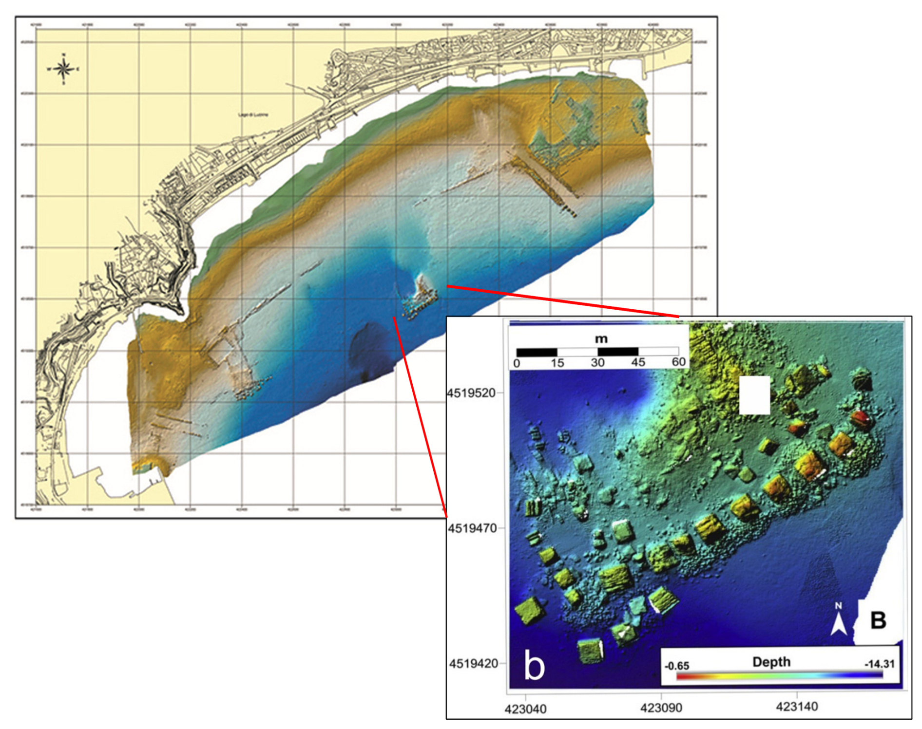
Figure A1The remains of Via Herculea currently located at 4–5 m b.s.l., with the columns of Opus Pilarum approximately 300 m away in the open sea. An enlargement of the structure of Opus Pilarum is also reported.
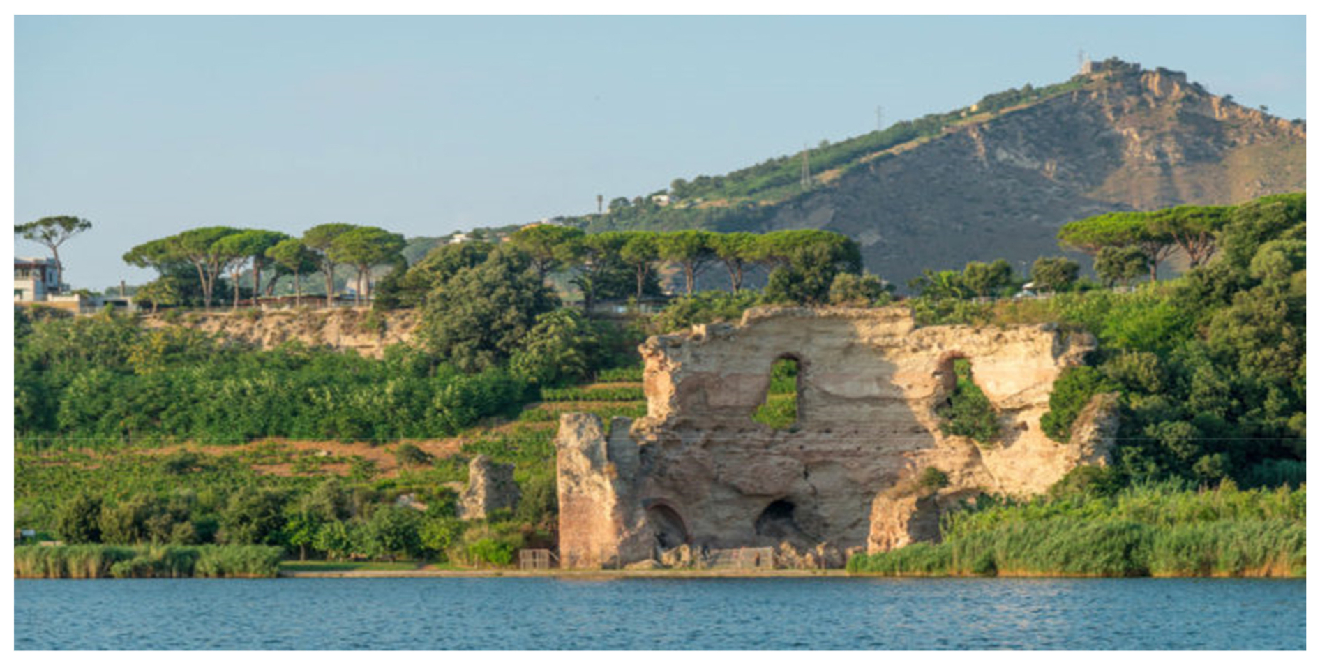
Figure A2The so-called Temple of Apollo on the east bank of the Averno. You can see the remains of a circular building with a “cap” vault, which later collapsed, typical of a “Truglio”, i.e. a spa building (from internet: https://fondoambiente.it/luoghi/tempio-di-apollo?ldc, last access: 18 May 2025).
Phases of submersion during the Greek age have been detected in the Pozzuoli area by Gauthier (1912), specifically in the eastern sector of Agnano. The author discovered Greek walls beneath the ruins of Roman baths that were restored in the 6th century CE. These, in turn, underlie lacustrine sediments that filled an ancient lake originally existing within the Agnano crater. However, the most evident subsidence phases have been recorded since Roman times by the structures of the so-called Temple of Serapis in Pozzuoli. Built in the 2nd century CE and restored and completed in the 3rd century CE, during the Severan era, this structure exhibits the typical architecture of a Roman market (“Macellum”).
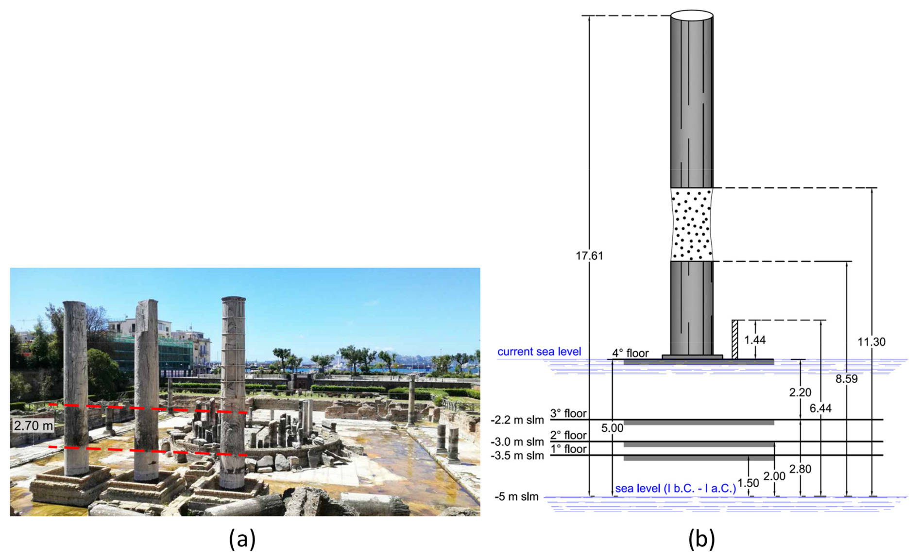
To determine whether the construction preceding the 2nd century CE had a connection with a temple, we must go back to 105 BCE, when a contract was stipulated between the municipality of Pozzuoli and a college of builders for repairs of public buildings (lex parieti faciundo). Among these was the Ades Serapis (Parascandola 1947), indicating that a temple dedicated to Serapis (an Alexandrian deity often regarded as protector of merchants and sailors) existed during this period. By the end of the 2nd century BCE, the cult of Serapis had spread throughout the Mediterranean, and its sanctuaries, as well as those of other Egyptian deities, were frequented by Roman-Italics. It is probable, therefore, that the introduction of the cult of Serapis in Pozzuoli is related to the presence of an Egyptian community in the Puteolan port (Soricelli 2007). It is important to try to establish the relationships between this building and the Macellum built later, specifically whether the Ades Serapis could have an ancestral link with a more recent cult building, which was then transformed into a typical Roman market. This relationship is suggested by the discovery of a statue of Jupiter Serapis during the excavations of the Macellum in 1750 (see below). However, data reconstructed by Amato and Gialanella (2013; Fig. 3) indicate that the first floor present in the substrate below the Macellum dates from the Flavian period (69–96 CE). The findings in the reworked pyroclastic materials, which are 4 m thick, below the first floor indicate a chronological interval between the end of the Republic and the beginning of the Empire (44 BCE–14 CE). This suggests that the Ades Serapis was likely built in a different position from the Macellum, with which it therefore has no ties. The architectural elements of the Macellum are part of the restoration works carried out on the Serapeo during the Severan Age (194–235 CE), with the installation of the fourth floor around 230 CE, located approximately 2 m above the third floor. The existing structure (Fig. 6), still present in the same area today, provides important evidence for reconstructing the ground movements. These movements can be identified in:
- -
The marble floor of the Macellum (fourth floor; see also Fig. B1).
- -
The height of the three columns of the pronaos (12.70 m high, with the first 6.2 m displaying a 2.70 m band perforated by lithophagus colonies (Fig. A3).
The historical information about the ground movements is schematised in Fig. 6 of the main text, as follows:
- -
1: in the 2nd century CE, the third floor of the Serapeo reached approximately 1 m a.s.l. It was sporadically invaded by the sea, to the point that it was considered appropriate to build a fourth floor in 230 CE, located at 2 m a.s.l.
- -
2: the flooding progressively affected the coast, leading to the transfer of ships from the port of Pozzuoli to Constantinople in 325–330 CE (Gianfrotta, 1993). It is important to highlight that the fourth floor was invaded by the sea in 394 CE. The bank was restored on the left side and the right side of the Macellum, in the area where structures functional to the port and the emporium were located, and, to protect it from the sea waves, with the construction of coastal embankments. These important works were supervised by the Campanian Consul Valerius Hermonius Maximus (Camodeca, 1987; Caruso, 2004).
- -
3: in the 6th–7th centuries, the citizens who had completely depopulated the lower part of Pozzuoli felt the need to take refuge in a sort of fortified citadel (castrum), equipped with a drawbridge, giving rise to the acropolis of the Rione Terra (Varriale, 2004).
- -
4: in the 9th–10th centuries, according to Parascandola (1947), the maximum submersion of the fourth floor of the Serapeo occurred. Due to the subsidence of the Pozzuoli area, between the 8th and 10th centuries, the Agnano plain, immediately east of Pozzuoli, was invaded by water due to the stagnation of thermal and rainwater, transforming it into a lake (Annecchino, 1931).
- -
5–7: in such a context, the most critical periods of the submersion phase occurred. The sea increasingly surrounded the Rione Terra, which appeared like a medieval village, with a drawbridge at the entrance to the cliff. The same context was depicted in the 11th century by the Arab geographer Idrisi in his Opus Geographicum, describing Pozzuoli as a “castle” (Varriale, 2004).
In the 12th century, subsidence was still active. A writing derived from an account of Benjamin ben Yonah de Tudela is considered, who, visiting the Jewish communities of the Mediterranean, passing through Pozzuoli, described the following: turres et fora in acqua demersa quae in media quondam fuerant (Russo Mailer, 1979; Caruso, 2004). The Pozzuoli district continued to subside in the 13th century, as can be deduced from an account written in 1251 by the historian Niccolò Jamsilla (Historia de rebus gestis Frederici II imperatoris ejeusque filorum Corradiet Manfredi Apuliaeet Siciliae regnum), who described the places between Agnano and Pozzuoli as follows: ...videlicet Putheolum mari mantibusque inaccessibilius circumquaque conclusum... (Fuiano, 1951).
In essence, what was observed by the Arab geographer Idris in the 11th century was also written by the historian Jamsilla in 1251, confirming that Rione Terra “was an unapproachable mountain completely surrounded by the sea”. This highlights that, over more than 3 centuries, the sea level rose due to subsidence of the tuffaceous walls of the Rione Terra.
- -
8: further eyewitness accounts from Boccaccio, who lived in Naples between 1327 and 1341, reported that a fisherman's wharf in the Bay of Pozzuoli became completely submerged (Mancusi, 1987). This document supports the description of the lower part of the city being completely submerged.
- -
9–10: a gouache from 1430, known as Bagno del Cantariello, part of the famous Balneis Puteolanis of the Edinburgh Codex (Di Bonito and Giamminelli, 1992), indicates the complete submergence of the fourth floor of the Serapeo by at least 10 m (Fig. 7). This context is supported by a description from 1441 indicating that, in 1441, “the sea covered the littoral plain, today called Starza” (De Jorio, 1820; Dvorak and Mastrolorenzo, 1991) (see Fig. 8).
For a more precise description of this morphological context, it is useful to refer to the excavation of the Serapeo carried out in 1750, when this monument was freed from the blanket of sediments that buried it (see Fig. 12), made up of approximately 8 m of filling sediments, plus 2 m of deposits from the pyroclastic flow of the M. Nuovo eruption. By replacing the latter materials with the approximately 2 m blade of sea water in the 1430 scenario (Fig. 7c), we arrive at the landscape picture in Fig. 7a, exemplified in Fig. 8d.
- -
11–13: these points on the curve were obtained by determining the extent of subsidence from 1580 to 1753, that is, respectively, the date on which the seismic phase after the 1538 eruption ended and the date on which the excavation work on the Serapeo ended. The subsidence was inferred by comparing the engraving of 1584 by Cartaro, representing the Caligoliano pier (Fig. 10a), and the engraving of the two testimonies: (a) that of the Caligoliano pier reproduced in the Cartaro engraving of 1584 (Fig. 10a) compared with its remains represented in an engraving from 1750 (Fig. 10b) and (b) with the same remains reported, more in detail, in another engraving of the middle of the 18th century (Fig. 10c); both engraving dates were reported by Maiuri (1927). A further constraint about the extent of subsidence in the mentioned period comes from the level of the fourth floor of the Serapeo, which was found at 0.7 m a.s.l. during the excavations of 1750–1753 (point 13) and was raised above sea level by 6–7 m until 1580. The subsidence was then estimated at 5 m.
- -
14: measurement by Niccolini at the end of 18th century (0.3 m a.s.l.).
- -
15–18: precise measurements of the height of the fourth floor, repeated by Lyell, Babbage and others until the end of the century (Parascandola, 1947).
The following points in the diagram, from the beginning of 1900 to 1950, were detected with precision instruments from the Military Geographic Institute (IGM), while the more recent ones (since 2000) were measured using the GPS methodology.
To better compare the past earthquakes with the recent and present-day seismicity recorded at Campi Flegrei, we must convert intensities to magnitudes. In Fig. 19, we present a tentative correlation between the epicentral intensity (Io) and the magnitude (ML). Choosing the correct relation between Io and ML is not straightforward, particularly in this case involving peculiar volcano-tectonic earthquakes. Nonetheless, it is important to establish such a relation to compare the seismicity observed during the 1430–1582 period, as inferred by Guidoboni and Cucciarelli (2011), with the seismicity experienced during the recent unrest phases. To determine the Io–ML relation, we are confident that, despite the availability of several formulas in the literature, the best approach is to consider a precise geographical and seismotectonic context, especially in a volcanic setting. Different features allow discrimination between volcanic and tectonic earthquakes, which suggests caution in using correlations derived from tectonic areas for volcanic earthquakes, and vice versa (Milana et al., 2010). In order to build a realistic relation between seismic intensity and magnitude in this area, we utilised the computed intensities of two earthquakes that occurred in the Campi Flegrei region in 1983 (Branno et al., 1984; Marturano et al., 1988; Milana et al., 2010; Charlton et al., 2020), during the previous unrest of 1982–1984 (Troise et al., 2019). Additionally, we considered an earthquake with M = 5.0 that occurred in the similar volcanic area of Colli Albani (Sabetta and Paciello, 1995). The M = 4.0 earthquake that occurred on 4 October 1983 at Campi Flegrei was found to have a maximum intensity Io = VII (Branno et al., 1984; Marturano et al., 1988). An earthquake of magnitude M = 3.5, which occurred in the same swarm on 4 October 1983, was found to have a maximum intensity Io = V (Fig. 19: Marturano et al., 1988). Furthermore, Sabetta and Paciello (1995) reported an earthquake of M = 5.0, with a maximum intensity Io = VIII.
These correlations between intensity and magnitude were utilised to assign realistic magnitude values to the macroseismic intensities deduced from the analysis of historical seismicity (Guidoboni and Cucciarelli, 2011), as shown in Fig. 19. They were also used to transform the magnitude of earthquakes associated with recent unrest phases into macroseismic intensities, as we will discuss later.
All raw data can be provided by the corresponding author upon request.
GR, GDN and CT analysed historical and volcanological data; GDN and CT analysed earthquake intensity/magnitude data; MS analysed seismic data; GR, MS and MDL wrote the paper draft and prepared the figures; GDN, CT and MS reviewed and edited the paper.
The contact author has declared that none of the authors has any competing interests.
Publisher’s note: Copernicus Publications remains neutral with regard to jurisdictional claims made in the text, published maps, institutional affiliations, or any other geographical representation in this paper. While Copernicus Publications makes every effort to include appropriate place names, the final responsibility lies with the authors.
The authors want to thank Marina Petrone and Gioia Molisso, who helped to recover some important Middle Age references on Campi Flegrei. Many thanks are also due to Christopher Kilburn and to the anonymous reviewer, who helped a lot to make the paper clearer.
This paper was edited by Amy Donovan and reviewed by Christopher Kilburn and one anonymous referee.
Acocella, V.: Evaluating fracture patterns within a resurgent caldera: Campi Flegrei, Italy, B. Volcanol., 72, 623–638, 2010.
Alberico, I., Petrosino, P., and Lirer, L.: Volcanic hazard and risk assessment in a multi-source volcanic area: the example of Napoli city (Southern Italy), Nat. Hazards Earth Syst. Sci., 11, 1057–1070, https://doi.org/10.5194/nhess-11-1057-2011, 2011.
Amato, L. and Gialanella, C.: New evidences on the Phlegraean bradyseism in the area of Puteolis harbour, in: Geotechnical Engineering for the Preservation of Monuments and Historic Sites, edited by: Bilotta, Flora, Lirer and Viggiani, Taylor and Francis, London, UK, 137–143, https://doi.org/10.13140/2.1.2326.0482, 2013.
Annecchino, R.: Agnano, l'origine del nome e del lago, Bollettino Flegreo, 5, 1931.
Aster, R. and Meyer, R.: Three-dimensional velocity structure and hypocenter distribution in the Campi Flegrei caldera, Italy, Tectonophysics, 149, 195–218, 1988.
Aucelli, P. P. C., Mattei, G., Caporizzo, C., Cinque, A., Troisi, S., Peluso, F., Stefanile, M., and Pappone, G.: Ancient Coastal Changes Due to Ground Movements and Human Interventions in the Roman Portus Julius (Pozzuoli Gulf, Italy): Results from Photogrammetric and Direct Surveys, Water, 12, 658, https://doi.org/10.3390/w12030658, 2020.
Bachmann, O. and Bergantz, G. W.: Gas percolation in upper-crustal silicic crystal mushes as a mechanism for upward heat advection and rejuvenation of near-solidus magma bodies, J. Volcanol. Geoth. Res., 149, 85–102, 2006.
Bachmann, O. and Huber, C.: Silicic mushes reservoirs in the Earth's crust, Am. Mineral., 101, 2377–2404, https://doi.org/10.2138/am-2016-5675, 2016.
Barberi, F., Corrado, G., Innocenti, F., and Luongo, G.: Phlegraean Fields 1982–1984: Brief Chronicle of a Volcano Emergency in a Densely Populated Area, B. Volcanol., 47, 175–185, 1984.
Battaglia, J., Zollo, A., Virieux, J., and Dello Iacono, D.: Merging active and passive data sets in traveltime tomography: The case study of Campi Flegrei caldera (Southern Italy), Geophys. Prospect., 56, 555–573, https://doi.org/10.1111/j.1365-2478.2007.00687.x, 2008.
Beauducel, F., De Natale, G., Obrizzo, F., and Pingue, F.: 3-D modelling of Campi Flegrei ground deformations: role of caldera boundary discontinuities, Pure Appl. Geophys., 161, 1329–1344, https://doi.org/10.1007/s00024-004-2507-4, 2004.
Bellucci, F., Woo, J., Kilburn, C.R.J., and Rolandi, G.: Ground deformation at Campi Flegrei, Italy: implications for hazard assessment, in: Mechanisms of Activity and Unrest at Large Calderas, edited by: Troise C., De Natale, G. and Kilburn, C.R.J., The Geological Society of London Special Publication, 269, 141–157, https://doi.org/10.1144/GSL.SP.2006.269.01.09, 2006.
Bergantz, G. W.: Underplating and partial melting: implications for melt generation and extraction, Science, 245, 1093–1095, https://doi.org/10.1126/science.245.4922.1093, 1989.
Boccaccio, G.: De Montibus, 1355–1373 (NDR: 1355–1373 is the period of publication, the exact date being uncertain).
Branno, A., Esposito, E., Luongo, G., Marturano, A., Porfido, S., and Rinaldis, V.: The October 4th, 1983 - Magnitude 4 earthquake in Phlegraean Fields: Macroseismic survey, Bull. Volcanol., 47, 233–238, https://doi.org/10.1007/BF01961553, 1984.
Burgisser, A. and Bergantz, G. W.: A rapid mechanism to remobilize and homogenize crystalline magma bodies, Nature, 471, 212–215, https://doi.org/10.1038/nature09799, 2011.
Calò, M. and Tramelli, A.: Anatomy of the Campi Flegrei caldera using enhanced seismic tomography models, Scientific Reports, 8, 16254, https://doi.org/10.1038/s41598-018-34456-x, 2018.
Camodeca, G.: Le antichità di Pozzuoli, la Ripa Puteolana e i resti sommersi del Porto Giulio, G. Macchiaroli Editore, Napoli, Italy, 1987.
Cannatelli, C., Spera, F. J., Bodnar, R. J., Lima, A., and De Vivo, B.: Ground movement (bradysesim) in the Campi Flegrei volcanic area: a review, in: Vesuvius, Campi Flegrei, and Campanian Volcanism, edited by: De Vivo, B., Belkin, H. E., and Rolandi, G., Elsevier, Chap. 15, 407–433, https://doi.org/10.1016/B978-0-12-816454-9.00015-8, 2020.
Cappelletti, P., Petrosino, P., De Gennaro, M., Colella, A., Graziano, S. F., D'Amore, M., Mercurio, M., Cerri, G., De Gennaro, R., Rapisardo, G., and Langella, A.: The “Tufo Giallo della Via Tiberina” (Sabatini Volcanic District, Central Italy): a complex system of lithification in a pyroclastic current deposit, Miner. Petrol., 109, 85–101, https://doi.org/10.1007/s00710-014-0357-z, 2015.
Capuano, P., Russo, G., Civetta, L., Orsi, G., D'Antonio, M. and R. Moretti, R.: The active portion of the Campi Flegrei caldera structure imaged by 3-D inversion of gravity data, Geochem. Geophys. Geosyst., 14, 4681–4697, https://doi.org/10.1002/ggge.20276, 2013.
Carrara, A., Burgisser, A., and Bergantz, G. W.: The architecture of intrusions in magmatic mush, Earth Planet. Sc. Lett., 549, 116539, https://doi.org/10.1016/j.epsl.2020.116539, 2020.
Caricchi, L., Annen, C., Blundy, J. D., Simpson, G., and Pinel, V.: Frequency and magnitude of volcanic eruptions controlled by magma injection and buoyancy, Nat. Geosci., 7, 126–130, https://doi.org/10.1038/ngeo2041, 2014.
Caruso, M.: Il territorio puteolano fra età romana e alto Medioevo, Bollettino Flegreo, Terza serie No. 17, 63–70, 2004.
Cashman, K. V., Sparks, R. S. J., and Blundy, J.: Vertically extensive and unstable crystals mushes: a unifying view of igneous processes associated with volcanoes, Science, 355, eaag3055, https://doi.org/10.1126/science.aag3055, 2017.
Charlton, D., Kilburn, C. R. J., and Edwards, S.: Volcanic unrest scenarios and impact assessment at Campi Flegrei caldera, Southern Italy, Journal of Applied Volcanology, 9, 7, https://doi.org/10.1186/s13617-020-00097-x, 2020.
Chiodini, G., Vandemeulebrouck, J., Caliro, S., D'Auria, L., De Martino, P., Mangiacapra, A., and Petrillo, Z.: Evidence of thermal driven processes triggering the 2005–2014 unrest at Campi Flegrei caldera, Earth Planet. Sc. Lett., 414, 58–67, https://doi.org/10.1016/j.epsl.2015.01.012, 2015.
Chiodini, G., Caliro, S., Avino, R., Bini, G., Giudicepietro, F., De Cesare, W., Ricciolino, P., Aiuppa, A., Cardellini, C., Petrillo, Z., Selva, J., Siniscalchi, A., and Tripaldi, S.: Hydrothermal pressure-temperature control on CO2 emissions and seismicity at Campi Flegrei (Italy), J. Volcanol. Geoth. Res., 414, 107245, https://doi.org/10.1016/j.jvolgeores.2021.107245, 2021.
Chouet, B. A.: Long-period volcano seismicity: its source and use in eruption forecasting, Nature, 380, 309–316, https://doi.org/10.1038/380309a0, 1996.
Cinque, A., Rolandi, G., and Zamparelli, V.: L'estensione dei depositi marini olocenici nei Campi Flegrei in relazione alla vulcanotettonica, Boll. Soc. Geol. Ital., 104, 327–348, 1983.
Colletta, T.: Pozzuoli, città fortificata in epoca vicereale, in una mappa inedita conservata alla Biblioteca Nazionale di Parigi, in: Storia dell'Urbanistica/Campania 1 – Pozzuoli, Supplemento Luglio-Dicembre, Edizioni Kappa, Rome, Italy, ISBN/EAN 2000000015873, 1988.
Costa, A., Di Vito, M. A., Ricciardi, G. P., Smith, V. C., and Talamo, P.: The long and intertwined record of humans and the Campi Flegrei volcano (Italy), B. Volcanol., 84, 5, https://doi.org/10.1007/s00445-021-01503-x, 2022.
D'Antonio, M., Civetta, L., Orsi, G., Pappalardo, L., Piochi, M., Carandente, A., De Vita, S., Di Vito, M. A., and Isaia, R.: The present state of the magmatic system of the Campi Flegrei caldera based on a reconstruction of its behavior in the past 12 ka, J. Volcanol. Geoth. Res., 91, 247–268, https://doi.org/10.1016/S0377-0273(99)00038-4, 1999.
De Jorio, A.: Ricerche sul Tempio de Serapide in Pozzuoli, Monumenti inediti di Antichità e Belle Arti, Stamperia della Società Filomatica, Naples, Italy, https://doi.org/10.11588/diglit.55421, 1820.
Del Gaudio, C., Aquino, I., Ricciardi, G. P., Ricco, C., and Scandone, R.: Unrest episodes at Campi Flegrei: A reconstruction of vertical ground movements during 1905–2009, J. Volcanol. Geoth. Res., 195, 48–56, https://doi.org/10.1016/j.jvolgeores.2010.05.014, 2010.
De Natale, G. and Pingue, F.: Ground deformations in collapsed caldera structures, J. Volcanol. Geoth. Res., 57, 19–38, https://doi.org/10.1016/0377-0273(93)90029-Q, 1993.
De Natale, G., Pingue, F., Allard, P., and Zollo, A.: Geophysical and geochemical modeling of the Campi Flegrei caldera, J. Volcanol. Geoth. Res., 48, 199–222, https://doi.org/10.1016/0377-0273(91)90043-Y, 1991.
De Natale, G., Petrazzuoli, S. M., and Pingue, F.: The effect of collapse structures on ground deformations in calderas, Geophys. Res. Lett., 24, 1555–1558, https://doi.org/10.1029/97GL01600, 1997.
De Natale, G., Troise, C., and Pingue, F.: A mechanical fluid-dynamical model for ground movements at Campi Flegrei caldera, J. Geodyn., 32, 487–517, https://doi.org/10.1016/S0264-3707(01)00045-X, 2001.
De Natale, G., Kuznetov, I., Krondrod, T., Peresan, A., Sarao, A., Troise, C., and Panza, G. F.: Three decades of seismic activity at Mt. Vesuvius: 1972–2000, Pure Appl. Geophys., 161, 123–144, https://doi.org/10.1007/s00024-003-2430-0, 2004.
De Natale, G., Troise, C., Pingue, F., Mastrolorenzo, G., Pappalardo, L., Battaglia, M., and Boschi, E.: The Campi Flegrei caldera: unrest mechanisms and hazards, in: Mechanisms of Activity and Unrest at Large Calderas, edited by: Troise C., De Natale, G., and Kilburn, C. R. J., The Geological Society of London, Special Publications, 269, 25–45, https://doi.org/10.1144/GSL.SP.2006.269.01.03, 2006.
De Natale, G., Troise, C., Mark, D., Mormone, A., Piochi, M., Di Vito, M. A., Isaia, R., Carlino, S., Barra, D., and Somma, R.: The Campi Flegrei Deep Drilling Project (CFDDP): New insight on caldera structure, evolution and hazard implications for the Naples area (Southern Italy), Geochem. Geophy. Geosy., 17, 4836–4847, https://doi.org/10.1002/2015GC006183, 2016.
De Natale, G., Petrazzuoli, S., Romanelli, F., Troise, C., Vaccari, F., Somma, R., Peresan, A., and Panza, G. F.: Seismic risk mitigation at Ischia island (Naples, Southern Italy): an innovative approach to mitigate catastrophic scenarios, Eng. Geol., 261, 105285, https://doi.org/10.1016/j.enggeo.2019.105285, 2019.
Di Bonito, R. and Giamminelli, R.: Le Terme dei Campi Flegrei, Topografia Storica, Jandi Sapi Editori, Milano-Roma, Italy, ISBN 9788871420127, 1992.
Di Girolamo, P., Ghiara, M. R., Lirer, L., Munno, R., Rolandi, G., and Stanzione, D.: Vulcanologia e petrologia dei Campi Flegrei, Boll. Soc. Geol. Ital., 103, 349–413, 1984.
Di Vito, M. A., Lirer, L., Mastrolorenzo, G., and Rolandi, G.: The Monte Nuovo eruption (Campi Flegrei, Italy), B. Volcanol., 49, 608–615, 1987.
Di Vito, M. A., Isaia, R., Orsi, G., Southon, J., De Vita, S., D'Antonio, M., Pappalardo, L., and Piochi, M.: Volcanism and deformations since 12,000 years at Campi Flegrei caldera, J. Volcanol. Geoth. Res., 91, 221–246, https://doi.org/10.1016/S0377-0273(99)00037-2, 1999.
Di Vito, M. A., Arienzo, I., Braia, G., Civetta, L., D'Antonio, M., Di Renzo, V., and Orsi, G.: The Averno 2 fssure eruption: a recent small-size explosive event at the Campi Flegrei caldera (Italy), B. Volcanol., 73, 295–320, https://doi.org/10.1007/s00445-010-0417-0, 2011.
Di Vito, M. A., Acocella, V., Aiello, G., Barra, D., Battaglia, M., Carandente, A., Del Gaudio, C., de Vita, S., Ricciardi, G. P., Ricco, C., Scandone, R., and Terrasi, F.: Magma transfer at Campi Flegrei caldera (Italy) before the 1538 AD eruption, Scientific Reports, 6, 32245, https://doi.org/10.1038/srep32245, 2016.
Dvorak, J. J. and Gasparini, P.: History of earthquakes and vertical ground movement in Campi Flegrei caldera, Southern Italy: comparison of precursory events to the A.D. 1538 eruption of Monte Nuovo and of activity since 1968, J. Volcanol. Geoth. Res., 48, 77–92, https://doi.org/10.1016/0377-0273(91)90034-W, 1991.
Dvorak, J. J. and Mastrolorenzo, G.: The mechanism of recent movements in Campi Flegrei caldera, Southern Italy, Geological Society of America, Special Papers, Vol. 263, https://doi.org/10.1130/SPE263, 1991.
Edmonds, M., Cashman, K. V., Holness, M., and Jackson, M.: Architecture and dynamics of magma reservoirs, Philos. T. Roy. Soc. A, 377, 2139, https://doi.org/10.1098/rsta.2018.0298, 2019.
Folch, A. and Gottsmann, J.: Faults and ground uplift at active calderas, in: Mechanisms of Activity and Unrest at Large Calderas, edited by: Troise C., De Natale, G., and Kilburn, C. R. J., The Geological Society of London Special Publication, 269, 25–45, https://doi.org/10.1144/GSL.SP.2006.269.01.07, 2006.
Fournier, R. O.: Hydrothermal processes related to movement of fluid from plastic into brittle rock in the magmatic epithermal environment, Econ. Geol., 94, 1193–1211, 1999.
Francisconi, G., Todesco, M., and Ciuccarelli, C.: Storia del Monte Nuovo, l'ultima eruzione dei Campi Flegrei, INGV Vulcani, https://ingvvulcani.com/2019/11/15/storia-del-monte-nuovo-lultima-eruzione-dei-campi-flegrei/ (last access: 18 May 2025), 2019.
Fuiano, M.: Niccolò Jamsilla, Atti dell'Accademia Pontaniana, Giannini, Napoli, Italy, Nuova, 3, 327–346, 1951.
Gauthier, V.: Il Bradisisma Flegreo all'epoca ellenica, Rend. Real Accad. Sci. Fis. e Mat. Naples, 3, 91–94, 1912.
Gianfrotta, P. A.: Puteoli sommersa, in: Puteoli, edited by: Zevi, F., Banco di Napoli, Naples, Italy, 115–124, ISBN/EAN 2570200339821, 1993.
Gretener, P. E.: On the mechanics of the intrusion of sills, Can. J. Earth Sci., 6, 1415–1419, https://doi.org/10.1139/e69-143, 1969.
Guidoboni, E.: Pozzuoli, terremoti e fenomeni vulcanici nel lungo periodo, in: Proceedings of VIII Convegno di Storia dell'Ingegneria, AISI-Associazione Italiana di Storia dell'Ingegneria, Naples, 11 December 2020, Vol. I, ISBN 978-88-86638-87-6, 2020.
Guidoboni, E. and Ciuccarelli, C.: The Campi Flegrei caldera: historical revision and new data on seismic crises, bradyseisms, the Monte Nuovo eruption and ensuing earthquakes (twelfth century 1582 AD), B. Volcanol., 73, 655–677, https://doi.org/10.1007/s00445-010-0430-3, 2011.
Hamilton, W.: Campi Phlegræi. Observations On The Volcanos Of The Two Sicilies As They Have Been Communicated To The Royal Society Of London, 2 vol., Napoli, 1776.
Huber, C., Bachmann, O., and Dufek, J.: Thermo-mechanical reactivation of locked crystal mushes: melting-induced internal fracturing and assimilation processes in magmas, Earth Planet. Sci. Lett., 304, 3-4, 443–454, https://doi.org/10.1016/j.epsl.2011.02.022, 2011.
Iervolino, I., Cito, P., De Falco, M., Herrmann, M., Lomax, A., Marzocchi, W., Santo, A., Strumia, C., Massaro, L., Scala, A., Scotto di Uccio, F., and Zollo, A.: Seismic risk mitigation at Campi Flegrei in volcanic unrest, Nat. Commun., 15, 10474, https://doi.org/10.1038/s41467-024-55023-1, 2024.
Insinga, D., Calvert, A. T., Lanphere, M. A., Morra, V., Perrotta, A., Sacchi, M., Scarpati, C., Saburomaru, J., and Fedele, L.: The Late-Holocene evolution of the Miseno area (southwestern Campi Flegrei) as inferred by stratigraphy, petrochemistry and 40Ar/39Ar geochronology, in: Volcanism in the Campania Plain: Vesuvius, Campi Flegrei and Ignimbrites, edited by: De Vivo, B., Developments in Volcanology, Elsevier, V, 97–124, https://doi.org/10.1016/S1871-644X(06)80020-3, 2006.
Isaia, R., Vitale, S., Di Giuseppe, M.G., Iannuzzi, E., D'Assisi Tramparulo, F., and Troiano, A.: Stratigraphy, structure, and volcano-tectonic evolution of Solfatara maar-diatreme (Campi Flegrei, Italy), Geol. Soc. Am. Bull., 127, 1485–1504, https://doi.org/10.1130/B31183.1, 2015.
Kilburn, C. R. J., De Natale, G., and Carlino, S.: Progressive approach to eruption at Campi Flegrei caldera in southern Italy, Nat. Commun., 8, 15312, https://doi.org/10.1038/ncomms15312, 2017.
Kilburn, C. R. J., Carlino, S., Danesi, S., and Pino, N. A.: Potential for rupture before eruption at Campi Flegrei caldera, Southern Italy, Communications Earth & Environment, 4, 190, https://doi.org/10.1038/s43247-023-00842-1, 2023.
Lanzarini, O.: I “trugli” dei bagni di Pozzuoli. Immagine e fortuna di due edifici termali antichi, Lexicon, 33, 7–20, https://doi.org/10.17401/lexicon.33.2021-lanzarini, 2021.
Lima, A., Bodnar, R. J., De Vivo, B., Spera, F. J., and Belkin, H. E.: Interpretation of Recent Unrest Events (Bradyseism) at Campi Flegrei, Napoli (Italy): Comparison of Models Based on Cyclical Hydrothermal Events versus Shallow Magmatic Intrusive Events, Geofluids, 2021, 2000255, https://doi.org/10.1155/2021/2000255, 2021.
Lima, A., Bodnar, R. J., De Vivo, B., Spera, F. J., and Belkin, H. E.: The “breathing” Earth at Solfatara-Pisciarelli, Campi Flegrei, southern Italy (2005–2024): Nature's attenuation of the effects of bradyseism, Am. Mineral., 110, 820–825, https://doi.org/10.2138/am-2024-9516, 2024.
Luongo, G., Cubellis, E., Obrizzo, F., and Petrazzuoli, S. M.: The mechanics of the Campi Flegrei resurgent caldera: a model, J. Volcanol. Geoth. Res., 45, 161–172, https://doi.org/10.1016/0377-0273(91)90056-6, 1991.
Maiuri, A.: I Campi Flegrei, Istituto poligrafico della Stato, Roma, 1927 (in Italian).
Mancusi, F.: Campi Flegrei, Sergio Civita Editore, Naples, Italy, 1987.
Martí, J., Lopez, C., Bartolini, S., Becerrill, L., and Geyer, A.: Stress controls of monogenic volcanism: A review, Frontiers in Earth Science, 4, 106, https://doi.org/10.3389/feart.2016.00106, 2016.
Marturano, A., Esposito, E., Porfido, S., and Luongo, G.: Il terremoto del 4 Ottobre 1983 (Pozzuoli); Attenuazione dell'intensità con la distanza e relazione magnitudo-intensità. Zonazione della città di Napoli, Mem. Soc. Geol. It., 41, 941–948, 1988.
Marsh, B. D.: Magma chambers, Annu. Rev. Earth Pl. Sc., 17, 439–472, https://doi.org/10.1146/annurev.ea.17.050189.002255, 1989.
Milana, G., De Sortis, A., and Rovelli, A.: Contenuto in bassa frequenza nei terremoti vulcanici del Monte Etna e danneggiamento degli edifici, Progettazione Sismica, 2, 81–93, 2010.
Moretti, R., Orsi, G., Civetta, L., Arienzo, I., and Papale, P.: Multiple magma degassing sources at an explosive volcano, Earth Planet. Sc. Lett., 367, 95–104, https://doi.org/10.1016/j.epsl.2013.02.013, 2013.
Moretti, R., De Natale, G., and Troise, C.: A geochemical and geophysical reappraisal to the significance of the recent unrest at Campi Flegrei caldera (Southern Italy), Geochem. Geophy. Geosy., 18, 1244–1269, https://doi.org/10.1002/2016GC006569, 2017.
Moretti, R., Troise, C., Sarno, F., and De Natale, G.: Caldera unrest driven by CO2-induced drying of the deep hydrothermal system, Scientific Reports, 8, 8309, https://doi.org/10.1038/s41598-018-26610-2, 2018.
Morhange, C., Bourcier, M., Laborel, J., Giallanella, C., Goiran, J., Crimaco, L., and Vecchi, L.: New data on historical relative sea level movements in Pozzuoli, Phlaegrean Fields, southern Italy, Phys. Chem. of the Earth, 24, 4, 349–54, https://doi.org/10.1016/S1464-1895(99)00040-X, 1999.
Morhange, C., Marriner, N., Laborel, J., Todesco, M., and Oberlin, C.: Rapid sea-level movements and noneruptive crustal deformations in the Phlegrean fields caldera, Italy, Geology, 34, 93–96, https://doi.org/10.1130/G21894.1, 2006.
Natale, J., Camanni, G., Ferranti, L., Isaia, R., Sacchi, M., Spiess, V., Steinmann, L., and Vitale, S.: Fault systems in the offshore sector of the Campi Flegrei caldera (southern Italy): Implications for nested caldera structure, resurgent dome, and volcano-tectonic evolution, J. Struct. Geol., 163, 104723, https://doi.org/10.1016/j.jsg.2022.104723, 2022.
Niccolini, A.: La gran terma puteolana, Dalla Stamperia Reale, Napoli, 1846 (in Italian).
Orsi, G., De Vita, S., and Di Vito, M.: The restless, resurgent Campi Flegrei nested caldera (Italy): constraints on its evolution and configuration, J. Volcanol. Geoth. Res., 74, 179–214, https://doi.org/10.1016/S0377-0273(96)00063-7, 1996.
Orsi, G., Civetta, L., Del Gaudio, C., de Vita, S., Di Vito, M. A., Isaia, R., Petrazzuoli, S. M., Ricciardi, G. P., and Ricco, C.: Short-term ground deformations and seismicity in the resurgent Campi Flegrei caldera (Italy): an example of active block-resurgence in a densely populated area, J. Volcanol. Geoth. Res., 91, 415–451, https://doi.org/10.1016/S0377-0273(99)00050-5, 1999.
Parascandola, A.: Il Monte Nuovo ed il Lago Lucrino, Boll. Soc. Nat. Napoli, 55, 151–312, 1943 (in Italian).
Parascandola, A.: I Fenomeni Bradisismici del Serapeo di Pozzuoli, Stabilimento Tipografico G. Genovese, Napoli, 1–117, 1947 (in Italian).
Parmigiani, A., Huber, C., and Bachmann, O.: Mush microphysics and the reactivation of crystal-rich magma reservoirs, J. Geophys. Res., 119, 6308–6322, https://doi.org/10.1002/2014JB011124, 2014.
Pasquarè, G., Poli, S., Venzolli L., and Zanchi A.: Continental arc volcanism and tectonic setting in central Anatolia, Turkey, Tectonophisycs, 146, 217–230, https://doi.org/10.1016/0040-1951(88)90092-3, 1988.
Petrarca, F.: Epystole, II, 15, 1343–1361 (NDR: 1343–1361 is the period of publication, the exact date being uncertain).
Rolandi, G., D'Alessio, G., and Di Vito, M.: Il sollevamento del suolo durante la fase preeruttiva del Monte Nuovo (Campi Flegrei), Rend. Acc., Sc. Fis. e Mat. in Napoli, 4, 15–34, 1985 (in Italian).
Rolandi, G., De Natale, G., Kilburn, C. R. J., Troise, C., Somma, R., Lascio, M., Fedele, A., and Rolandi, R.: The 39 ka Campanian Ignimbrite eruption: new data on source area in the Campanian Plain, in: Vesuvius, Campi Flegrei, and Campanian Volcanism, edited by: Vivo, B., Belkin, H. E., and Rolandi, G., Elsevier, Chap. 8, 175–205, https://doi.org/10.1016/B978-0-12-816454-9.00008-0, 2020a.
Rolandi, G., Di Lascio, M., and Rolandi, R.: The Neapolitan Yellow Tuff eruption as the source of the Campi Flegrei caldera, in: Vesuvius, Campi Flegrei, and Campanian Volcanism, edited by: Vivo, B., Belkin, H. E., and Rolandi, G., Elsevier, Chap. 11, 273–296, https://doi.org/10.1016/B978-0-12-816454-9.00011-0, 2020b.
Rosi, M. and Sbrana, A.: Phlegrean fields, Quaderni de La Ricerca Scientifica Consiglio Nazionale delle Ricerche, 9, 1–175, 1987.
Russo Mailer, C.: La tradizione Medioevale dei bagni flegrei, Puteoli, studi di storia antica, III, 141–153, 1979.
Sabetta, F. and Paciello, A.: Valutazione della pericolosità sismica, La geologia di Roma – Memorie descrittive della carta geologica d'Italia, 50, 443–449, ISBN 978-88-240-3970-3, 1995.
Sacchi, M., Pepe, F., Corradino, M., Insinga, D. D., Molisso, F., and Lubritto C.: The Neapolitan Yellow Tuff caldera offshore the Campi Flegrei: stratal architecture and kinematic reconstruction during the last 15 ky, Mar. Geol., 354, 5–33, https://doi.org/10.1016/j.margeo.2014.04.012, 2014.
Sacchi, M., Passaro, S., Molisso, F., Matano, F., Steinmann, L., Spiess, V., Pepe, F., Corradino, M., Caccavale, M., Tamburrino, S., Esposito, G., Vallefuoco, M., and Ventura, G.: The Holocene marine record of unrest, volcanism, and hydrothermal activity of Campi Flegrei and Somma Vesuvius,, in: Vesuvius, Campi Flegrei, and Campanian Volcanism, edited by: Vivo, B., Belkin, H. E., and Rolandi, G., Elsevier, Chap. 16, 435–469, https://doi.org/10.1016/B978-0-12-816454-9.00016-X, 2020a.
Sacchi, M., Matano, F., Molisso, F., Passaro, S., Caccavale, M., Di Martino, G., Guarino, A., Innangi, S., Tamburrino, S., Tonielli, R., and Vallefuoco, M.: Geological framework of the Bagnoli-Coroglio coastal zone and continental shelf, Pozzuoli (Napoli) Bay, Chem. Ecol., 36, 529–549, https://doi.org/10.1080/02757540.2020.1735374, 2020b.
Scandone, R., D'Amato, J., and Giacomelli, L.: The relevance of the 1198 eruption of Solfatara in the Phlegraean Fields (Campi Flegrei) as revealed by medieval manuscripts and historical sources, J. Volcanol. Geoth. Res., 189, 202–206, https://doi.org/10.1016/j.jvolgeores.2009.09.012, 2010.
Scarpa, R., Bianco, F., Capuano, P., Castellano, M., D'Auria, L., Di Lieto, B., and Romano, P.: Historic Unrest of the Campi Flegrei Caldera, Italy, in: Campi Flegrei. Active Volcanoes of the World, edited by: Orsi, G., D'Antonio, M., and Civetta, L., Springer, Berlin, Heidelberg, 257–282, https://doi.org/10.1007/978-3-642-37060-1_10, 2022.
Selva, J., Orsi, G., Di Vito, M., Marzocchi, W., and Sandri, L.: Probability hazard map for future vent opening at the Campi Flegrei caldera, Italy, B. Volcanol., 2, 497–510, https://doi.org/10.1007/s00445-011-0528-2, 2011.
Shelly, D. and Hurwitz, S.: Yellowstone caldera chronicles, Yellowstone Volcano Observatory, USGS, https://www.usgs.gov/observatories/yvo/news/water- released-crystallizing-magma-can-trigger-earthquakes-yellowstone (last access: 18 May 2025), 5 September 2022.
Smith, V. C., Isaia, R., and Pearce, N. J. G.: Tephrostratigraphy and glass compositions of post-15 kyr Campi Flegrei eruptions: implications for eruption history and chronostratigraphic markers, Quaternary Sci. Rev., 30, 3638–3660, https://doi.org/10.1016/j.quascirev.2011.07.012, 2011.
Somma, R., Iuliano, S., Matano, F., Molisso, F., Passaro, S., Sacchi M., Troise C., and De Natale, G.: High-resolution morphobathymetry of Pozzuoli Bay, southern Italy, J. Maps, 12, 222–230, https://doi.org/10.1080/17445647.2014.1001800, 2016.
Soricelli, G.: Comunità orientali a Puteoli, Presses universitaires de Rennes, 129–144, https://doi.org/10.4000/books.pur.6714, 2007.
Steinmann, L., Spiess, V., and Sacchi, M.: The Campi Flegrei caldera (Italy): Formation and evolution in interplay with sea-level variations since the Campanian Ignimbrite eruption at 39 ka, J. Volcanol. Geoth. Res., 327, 361–374, https://doi.org/10.1016/j.jvolgeores.2016.09.001, 2016.
Steinmann, L., Spiess, V., and Sacchi, M.: Post-collapse evolution of a coastal caldera system: Insight from a 3D multichannel seismic survey from the Campi Flegrei caldera (Italy). J. Volcanol. Geoth. Res., 349, 83–98, https://doi.org/10.1016/j.jvolgeores.2017.09.023, 2018.
Strabone: Rerum Geographicarum, book V, Chap. 4–5, 1 century BC–1 century AD.
Talavera Montes, A. J.: Eruzioni, sismi e bradisismo nei Campi Flegrei in epoca romana tra fonti storiche ed evidenze archeologiche e geologiche, in: Living with Seismic Phenomena in the Mediterranean and Beyond between Antiquity and the Middle Ages Proceedings of Cascia (25–26 October 2019) and Le Mans (2–3 June 2021) Conferences, edited by: Compatangelo Soussignan, R., Diosono, F., and Le Blay, F., Archaeopress Publishing Ltd, Oxford, 194 pp., 2021 (in Italian).
Troise, C., Pingue, F., and De Natale, G.: Coulomb stress changes at calderas: Modeling the seismicity of Campi Flegrei (Southern Italy), J. Geophys. Res., 108, 2292, https://doi.org/10.1029/2002JB002006, 2003.
Troise, C., De Natale, G., Schiavone, R., Somma, R., and Moretti, R.: The Campi Flegrei caldera unrest: Discriminating magma intrusions from hydrothermal effects and implications for possible evolution, Earth Sci. Rev., 188, 108–122, https://doi.org/10.1016/j.earscirev.2018.11.007, 2019.
Vanorio, T., Prasad, M., Patella, D., and Nur, A.: Ultrasonic velocity measurements in volcanic rocks: Correlation with microtexture, Geophys. J. Int., 149, 22–36, https://doi.org/10.1046/j.0956-540x.2001.01580.x, 2002.
Vanorio, T., Virieux, J., Capuano, P., and Russo, G.: Three-dimensional seismic tomography from P wave and S wave microearthquake travel times and rock physics characterization of the Campi Flegrei Caldera, J. Geophys. Res., 110, B03201, https://doi.org/10.1029/2004JB003102, 2005
Vanorio, T. and Kanitpanyacharoen, W.: Rock physics of fibrous rocks akin to Roman concrete explains uplifts at Campi Flegrei Caldera, Science, 349, 617–621, https://doi.org/10.1126/science.aab1292, 2015.
Varriale, I.: Costa Flegrea ed attività bradisismica dall'antichità ad oggi, in: Rotte e Porti del Mediterraneo dopo la caduta dell'Impero romano d'Occidente, IV seminario, Genova, Italy, 18–19 July, edited by: De Maria, L. and Turchetti, R., ISBN 9788849811179, 291–310, 2004.
Vinciguerra, S., Trovato, C., Meredith, P. G., Benson, P. M., Troise, C., and De Natale, G.: Understanding the Seismic Velocity Structure of Campi Flegrei Caldera (Italy): From the Laboratory to the Field Scale, Pure Appl. Geophys., 163, 2205–2221, https://doi.org/10.1007/s00024-006-0118-y, 2006.
Wohletz, K. H.: Mechanisms of hydrovolcanic pyroclast formation: grain-size, scanning electron microscopy and experimental results, J. Volcanol. Geotherm. Res., 17, 31–63, https://doi.org/10.1016/0377-0273(83)90061-6, 1983.
Woo, J. Y. L. and Kilburn, C. R. J.: Intrusion and deformation at Campi Flegrei, southern Italy: Sills, dikes, and regional extension, J. Geophys. Res., 115, B12210, https://doi.org/10.1029/2009JB006913, 2010.
Wunderman, R. (Ed.): Global volcanism Program. Report on Hekla (Iceland), Bulletin of the Global Volcanism Network, 25:6, https://doi.org/10.5479/si.GVP.BGVN200006-372070, 2000.
Zollo, A., Maercklin, N., Vassallo, M., Dello Iacono, D., Virieux, J., and Gasparini, P.: Seismic reflections reveal a massive melt layer feeding Campi Flegrei caldera, Geophys. Res. Lett., 35, L12306, https://doi.org/10.1029/2008GL034242, 2008.
- Abstract
- Introduction
- Caldera formation and post-caldera volcanic activity 14–3.7 ka
- Subsidence and uplift evolution before the 1538 eruption
- Ground movements after the 1538 eruption
- Schematic model of the preparatory phases of the 1538 eruption
- The seismicity before and after the 1538 eruption
- Comparison of precursory phases of the 1538 eruption with current unrest
- Conclusion
- Appendix A: Evolution of the vertical movements involving Via Herculea
- Appendix B: Evolution of the ground movements involving the Pozzuoli area
- Appendix C: Comparing past and recent earthquakes: from intensity to magnitude
- Data availability
- Author contributions
- Competing interests
- Disclaimer
- Acknowledgements
- Review statement
- References