the Creative Commons Attribution 4.0 License.
the Creative Commons Attribution 4.0 License.
 | 25 Jun 2025
Brief communication: Bridging the data gap – a call to enhance the representation of global coastal flood protection
Joël J.-F. G. De Plaen
Timothy Tiggeloven
Maria Luisa Colmenares
Philip J. Ward
Paolo Scussolini
Elco Koks
Understanding coastal flood protection is crucial for assessing risks from natural hazards and climate change. However, there is a significant lack of quantitative data on coastal flood protection and related standards, posing a major barrier to risk assessment. The FLOod PROtection Standards (FLOPROS) database, currently the only global database of flood protection standards, relies on limited coastal observations and simplified assumptions. While widely used, it cannot adequately constrain uncertainties in risk estimates that are based on it. To address this gap, we call for a global, community-driven effort to develop a more comprehensive dataset. As a first step, we present a dataset compiling COASTtal flood PROtection Standards within EUrope (COASTPROS-EU), elaborated from a survey distributed to flood practitioners from several European countries. This highlights the need for more extensive and coordinated data collection efforts, using a transdisciplinary community-based approach that ensures diverse societal representation.
- Article
(1025 KB) - Full-text XML
-
Supplement
(565 KB) - BibTeX
- EndNote


In Europe alone, damage costs from coastal flooding currently amount to EUR 1.4 billion annually, with around 100 000 people exposed (Feyen et al., 2020). The rise in global temperatures caused by anthropogenic greenhouse gas emissions means that the frequency and severity of coastal flood events are projected to increase over the next decades, for example due to sea level rise (Taherkhani et al., 2020). Concurrently, the degradation of foreshore vegetation and human-induced subsidence due to land use and sediment retention by dams contribute to heightened coastal flood hazards. This presents significant challenges for low-lying coastal communities and ecosystems, which are home to a large portion of the world's population, land area, and assets (Bevacqua et al., 2020; Reguero et al., 2015).
The latest IPCC synthesis report warns of significant, irreversible damage to coastal areas from climate-induced flooding, with the coastal flood hazard continuing to increase well beyond 2100 due to sea level rise (IPCC, 2023). Additionally, exposure to coastal flood events is expected to increase in the future due to factors such as increasing urbanization in coastal areas (Darlington et al., 2023; Reimann et al., 2023; Neumann et al., 2015).
Addressing coastal flood risk and understanding the potential future impacts requires a comprehensive understanding of current coastal flood protection measures and standards, in terms of both infrastructure (e.g. levees) and nature-based solutions (e.g. mangroves) (Caretta et al., 2022; van Zelst et al., 2021; Toimil et al., 2020). However, the complexity of and challenges involved in quantitatively assessing the level of protection that existing flood defences provide hinders our understanding of flood protection on a global scale. For example, challenges arise due to the complex interactions between natural (e.g. dunes) and artificial (e.g. dikes) barriers (Hinkel et al., 2021). Enhanced and detailed data on coastal flood protection are necessary to better prepare for and mitigate the risks associated with climate change and coastal flooding.
In 2016, Scussolini et al. (2016) introduced the FLOPROS database, providing the first global collection of information on flood protection standards across different spatial scales. It consolidates information on the protection standards (expressed as flood return periods) associated with protection measures and regulations. FLOPROS is structured in three layers: the design layer, which details the engineered protection levels of existing river and coastal flood infrastructure derived from the literature; the policy layer, which specifies legislative and normative standards for protection from river and coastal floods, also derived from the literature; and the model layer, which infers river flood protection standards based on observed relationships with per capita wealth and flood risk.
The FLOPROS model layer assumes a maximum flood protection of a 1000-year return period and a minimum of a 2-year return period (no protection). An algorithm interpolates these values based on GDP per capita for different income regions. The model layer determines the protection standards for sub-country administrative units (the second level of nomenclature of territorial units for statistics, or NUTS2, according to Eurostat, 2018) by calculating the expected annual damage and interpolating additional units linearly. This approach overlooks the complexities of the various physical, socio-economic, and governance factors that influence flood protection standards, both between and within regions (Klijn et al., 2021).
To our knowledge, FLOPROS, with its coastal update by Tiggeloven et al. (2020), is the only global dataset documenting existing structural flood protection measures at the sub-national level, making it a cornerstone in contemporary research endeavours that assess flood risk. Consequently, the database is frequently used in coastal flood assessments (e.g. Almar et al., 2021; Hermans et al., 2023; Vousdoukas et al., 2018; Yesudian and Dawson, 2021; Ward et al., 2017). FLOPROS was created to support research related to large-scale flood risk management and has been utilized in several high-level policy documents, including PESETA IV (Feyen et al., 2020; PBL, 2023; UNEP, 2023). Initiatives such as the Inter-sectoral Model Intercomparison Project (ISIMIP), which integrates these findings into integrated assessment models like REMIND (Sauer et al., 2021), and web tools such as Aqueduct Floods also rely on FLOPROS. Additionally, many academic studies assessing current and future flood risk in coastal areas depend on the FLOPROS database (e.g. Chen et al., 2023; Tiggeloven et al., 2020; Mortensen et al., 2024; Vousdoukas et al., 2020; Hermans et al., 2023; Devitt et al., 2023; Haasnoot et al., 2021). As a result, FLOPROS is fundamental to current flood protection assumptions for coastal flood risk and impact assessments.
However, due to the limitations of FLOPROS, especially the limited number of observations for coastal flood protection (54 data points from 14 countries), we argue that caution should be exercised when utilizing it in coastal contexts. Overreliance on the dataset may lead to an underestimation of future climate risks, implying protection where it does not exist, or an overestimation of adaptation efforts, thus undermining the urgency of climate mitigation.
Since the publication of FLOPROS, several initiatives have aimed to improve the representation of flood protection for coastal regions. FLOPROS mostly contains information on river flood protection in its design and policy layers and has information exclusively on river flood protection in its model layer. Tiggeloven et al. (2020) extended this by calculating flood protection for coastal regions globally using a comparable model-based approach but did not include policy or design layers, which may lead to uncertainty. Despite these advancements, a lack of a clear distinction between the use of the original FLOPROS by Scussolini et al. (2016) and its updated version by Tiggeloven et al. (2020) remains. Frequently, both versions are cited without specifying whether the coastal protection levels used are from the design, policy, or model layer (Yesudian and Dawson, 2021). A notable relevant advancement is openDELve, which compiles an open database referencing the extent and design specifications of levees for 152 deltas, including levee height, crest width, and construction material, in a harmonized format (Nienhuis et al., 2022). However, there is a clear contrast in data availability between regions such as Africa, Southeast Asia, and South and Central America in comparison to Australia, Europe, the UK, and the USA (Nienhuis et al., 2022). Another significant research direction is the detection of flood defence infrastructure from high-resolution elevation data. Wing et al. (2019) used a detection algorithm to map levees in the contiguous USA, questioning the validity of the wealth-to-protection relationships used in FLOPROS. A similar method was subsequently applied by Sasaki et al. (2023).
Knowledge of river flood protection standards has been enhanced by studies such as that of Boulange et al. (2021), which reflect the protection provided downstream of global hydro dams. In China, river flood protection standards at higher resolution and confidence levels are available thanks to Wang et al. (2021). Advanced statistical approaches trained to infer flood protection standards from physical and socio-economic variables have been developed by Zhao et al. (2023). An indirect approach to infer flood protection standards for Europe using new data on impacts and potential flood occurrences was recently implemented by Paprotny et al. (2024).
Despite various advancements in recent years, a dataset with comprehensive global representation of coastal flood protection measures and their standards is still lacking. We present here COASTtal flood PROtection Standards within EUrope (COASTPROS-EU), a new database on policy standards and defence structures along the European coast (Table S1 in the Supplement). The database builds upon the efforts of FLOPROS and its subsequent improvement by Tiggeloven et al. (2020). However, it differs from FLOPROS by specifically compiling information on European coastal defences for each NUTS2 region. Furthermore, it references three typologies of layers, namely geolocated coastal defences, regional coastal defence policies, and modelled defences based on Tiggeloven et al. (2020). Where applicable, flood protection standards are expressed in return periods. The summary return period summarizes the most accurate information layer type regarding flood protection collected. This column prioritizes the layer types in the following order: (a) geolocated coastal defences, (b) policy standards, and, lastly, (c) modelled defence if no other information is applicable. The overview of the data availability summary is mapped in Fig. 1. The database was produced through two key initiatives. First, an online survey was distributed within the networks of the CoCliCo project (European Union's Horizon 2020 research and innovation programme Coastal Climate Core Services under grant agreement no. 101003598) and the Institute for Environmental Studies (IVM) of Vrije Universiteit Amsterdam. Second, a data workshop was held at Vrije Universiteit Amsterdam in November 2023, where flood experts collected information on flood defence and protection standards in their respective languages using the academic and grey literature (policy reports and governmental data portals) (Koks and De Plaen, 2023).
The survey consists of an online form targeting flood experts. It collects information related to the scale of the protection measure, the area protected, the flood protection level expressed in the return period, and the year of implementation. In the case of a lack of information on physical defences, an indication of policy standards applicable to the area could be filled in by the associated policy measure. Finally, additional data such as geospatial layer or other relevant information could be uploaded. The information collected was then manually summarized in the geospatial and policy layers of the database. The survey answers were then archived in an Excel file referenced in the Zenodo repository (De Plaen et al., 2024).
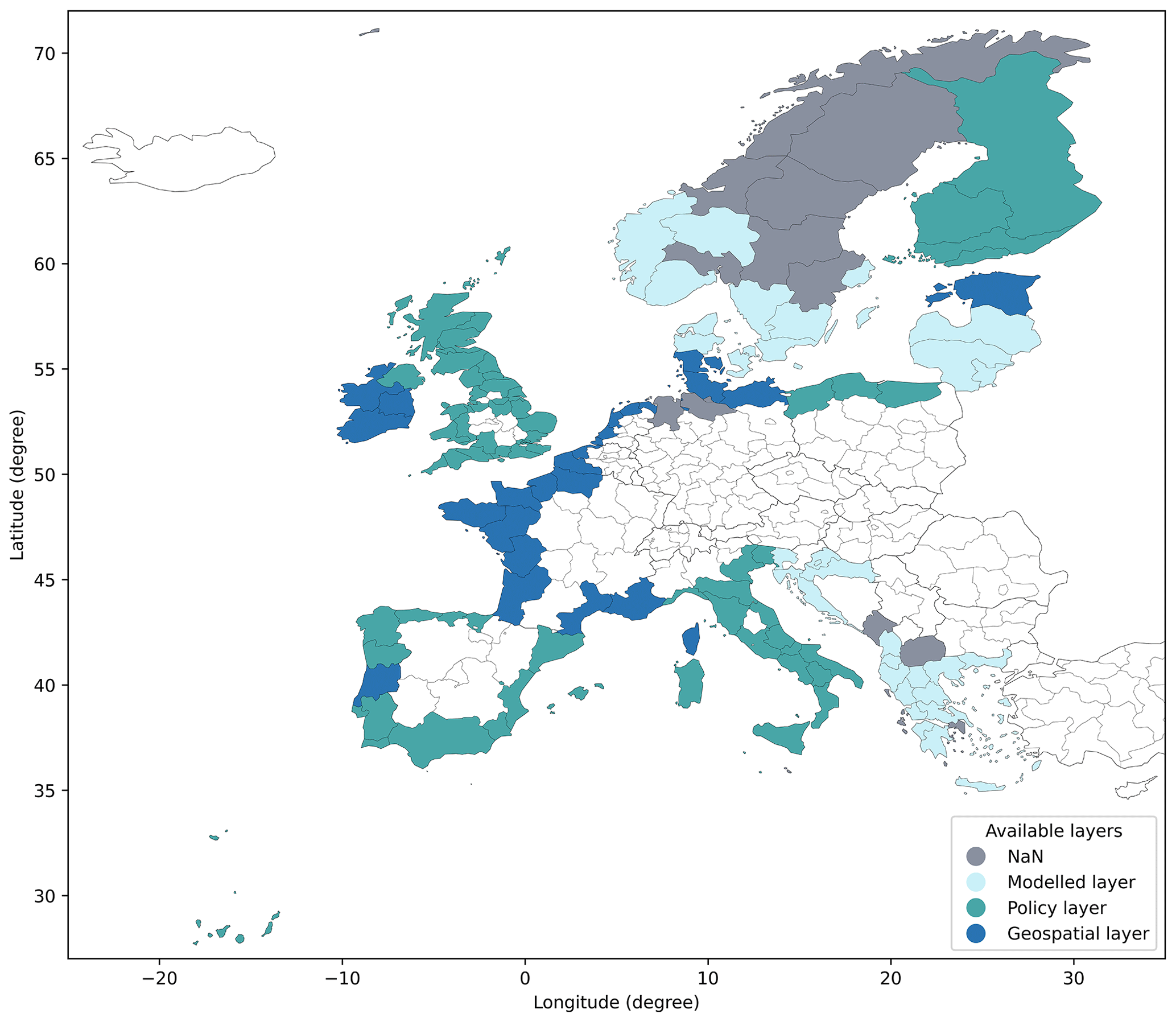
Figure 1Data availability overview of COASTPROS-EU, representing the best-available coastal protection standards in Europe per NUTS2 region for three typologies of layers: geolocated coastal defences, policy standards, and modelled defence standards.
Through these combined efforts, we aim to provide a more accurate and comprehensive understanding of coastal flood protection measures. By incorporating diverse data sources and methodologies, this new database addresses the critical need for detailed, reliable information to better prepare for and mitigate the risks associated with climate change and coastal flooding.
While this dataset marks an initial step, certain limitations must be acknowledged. Firstly, our new dataset is restricted to Europe and therefore does not meet the need for a global assessment. Moreover, the way that protection levels are quantified and evaluated is critical. Current approaches mainly rely on return periods, providing a standardized framework suitable for large-scale or regional analyses, with the flexibility to convert between return periods and defence heights. However, incorporating defence heights remains essential, as their significance varies depending on the specific context and research questions.
A global effort is needed to improve data on coastal flood protection, ensuring representation across diverse social groups, languages, and data-scarce regions. This requires a structured, transdisciplinary approach that integrates institutional support, community-driven data collection, and multiple sources of information to enhance flood risk assessments and policy alignment.
Our dataset provides a starting point, but a broader, more structured effort beyond academia is necessary. Institutional support is key to ensuring sustained data collection and standardized national-level reporting. Cultural differences in flood protection – such as variations in design standards and their local implementation – must be captured. While FLOPROS and COASTPROS remain relevant, future efforts must expand coverage, improve accessibility, and establish globally consistent methodologies.
Earth observation data remain essential for large-scale assessments of coastal flood protection, offering standardized insights into infrastructure and nature-based solutions. However, satellite data alone are insufficient. A multi-method approach integrating satellite-derived information with local expertise, participatory mapping, and national policy assessments is critical. OpenStreetMap (OSM) provides an opportunity for community-driven mapping, particularly in regions lacking official records. Aligning these efforts with structured policy reviews and national reporting frameworks will bridge the gap between local knowledge and institutional decision-making.
Standardized national-level reporting is crucial for improving flood risk assessments and ensuring cross-country comparability. Systematic reviews of national policies, including flood design standards and their local application, will enhance data consistency and policy impact. Rather than relying solely on surveys, concrete recommendations should guide reporting frameworks and promote best practices. By integrating institutional expertise, satellite observations, and community-driven contributions, we can build a more comprehensive and equitable approach to flood risk assessment – one that strengthens resilience worldwide.
The Excel file and GIS shapefile of COASTPROS-EU are available on the following repository: https://doi.org/10.5281/zenodo.15024139 (De Plaen et al., 2025).
The supplement related to this article is available online at https://doi.org/10.5194/nhess-25-2075-2025-supplement.
All authors (NvM, JJFGDP, TT, MLC, PJW, PS, EK) contributed to the research design. NvM and JJFGDP drafted the original manuscript. JJFGDP, EK, and MLC compiled the dataset and created the figure. TT, MLC, PJW, PS, and EK reviewed and revised the paper.
At least one of the (co-)authors is a member of the editorial board of Natural Hazards and Earth System Sciences. The peer-review process was guided by an independent editor, and the authors also have no other competing interests to declare.
Publisher’s note: Copernicus Publications remains neutral with regard to jurisdictional claims made in the text, published maps, institutional affiliations, or any other geographical representation in this paper. While Copernicus Publications makes every effort to include appropriate place names, the final responsibility lies with the authors.
This research has been supported by the Horizon 2020 projects CoCliCo (grant no. 101003598) and MYRIADEU (grant no. 101003276). This research was also supported by the ESA EO4MULTIHAZARDS (Earth Observation for High-Impact Multi-Hazards Science), funded by the European Space Agency and launched as part of the joint ESA–European Commission Earth System Science Initiative.
This paper was edited by Ira Didenkulova and reviewed by two anonymous referees.
Almar, R., Ranasinghe, R., Bergsma, E. W. J., Diaz, H., Melet, A., Papa, F., Vousdoukas, M., Athanasiou, P., Dada, O., Almeida, L. P., and Kestenare, E.: A global analysis of extreme coastal water levels with implications for potential coastal overtopping, Nat. Commun., 12, 3775, https://doi.org/10.1038/s41467-021-24008-9, 2021.
Bevacqua, E., Vousdoukas, M. I., Zappa, G., Hodges, K., Shepherd, T. G., Maraun, D., Mentaschi, L., and Feyen, L.: More meteorological events that drive compound coastal flooding are projected under climate change, Commun. Earth Environ., 1, 47, https://doi.org/10.1038/s43247-020-00044-z, 2020.
Boulange, J., Hanasaki, N., Yamazaki, D., and Pokhrel, Y.: Role of dams in reducing global flood exposure under climate change, Nat. Commun., 12, 417, https://doi.org/10.1038/s41467-020-20704-0, 2021.
Caretta, A. M. M. A., Arfanuzzaman, R. B. M., Morgan, S. M. R., and Kumar, M.: Water, in: Climate Change 2022: Impacts, Adaptation, and Vulnerability. Contribution of Working Group II to the Sixth Assessment Report of the Intergovernmental Panel on Climate Change, https://doi.org/10.1017/9781009325844, 2022.
Chen, J., Shi, X., Gu, L., Wu, G., Su, T., Wang, H.-M., Kim, J.-S., Zhang, L., and Xiong, L.: Impacts of climate warming on global floods and their implication to current flood defense standards, J. Hydrol., 618, 129236, https://doi.org/10.1016/j.jhydrol.2023.129236, 2023.
Darlington, C., Raikes, J., Henstra, D., Thistlethwaite, J., and Raven, E. K.: Mapping current and future flood exposure using a 5 m flood model and climate change projections, Nat. Hazards Earth Syst. Sci., 24, 699–714, https://doi.org/10.5194/nhess-24-699-2024, 2024.
De Plaen, J. J.-F. G., Colmenares, M., Koks, E., Scussolini, P., Lena, R., Lincke, D., Kiesel, J., Wolff, C., Tiggeloven, T., Peregrina Gonzalez, E. D., Le Cozannet, G., and Sayers, P.: COASTPROS-EU, Zenodo [data set], https://doi.org/10.5281/zenodo.15024139, 2025.
Devitt, L., Neal, J., Coxon, G., Savage, J., and Wagener, T.: Flood hazard potential reveals global floodplain settlement patterns, Nat. Commun., 14, 2801, https://doi.org/10.1038/s41467-023-38297-9, 2023.
Du, S., Scussolini, P., Ward, P. J., Zhang, M., Wen, J., Wang, L., Koks, E., Diaz-Loaiza, A., Gao, J., Ke, Q., and Aerts, J. C. J. H.: Hard or soft flood adaptation? Advantages of a hybrid strategy for Shanghai, Global Environ. Change, 61, 102037, https://doi.org/10.1016/j.gloenvcha.2020.102037, 2020.
Eurostat European Commission: Regions in the European Union-Nomenclature of territorial units for statistics NUTS 2016, Eurostat European Commission, 2018.
Feyen, L., Ciscar Martinez, J. C., Gosling, S., Ibarreta Ruiz, D., Soria Ramirez, A., Dosio, A., Naumann, G., Russo, S., Formetta, G., and Forzieri, G.: Climate change impacts and adaptation in Europe, JRC PESETA IV final report, Joint Research Centre, https://doi.org/10.2760/171121, 2020.
Haasnoot, M., Winter, G., Brown, S., Dawson, R. J., Ward, P. J., and Eilander, D.: Long-term sea-level rise necessitates a commitment to adaptation: A first order assessment, Climate Risk Management, 34, 100355, https://doi.org/10.1016/j.crm.2021.100355, 2021.
Hermans, T. H. J., Malagón-Santos, V., Katsman, C. A., Jane, R. A., Rasmussen, D. J., Haasnoot, M., Garner, G. G., Kopp, R. E., Oppenheimer, M., and Slangen, A. B. A.: The timing of decreasing coastal flood protection due to sea-level rise, Nat. Clim. Change, 13, 359–366, https://doi.org/10.1038/s41558-023-01616-5, 2023.
Hill, K.: Coastal infrastructure: a typology for the next century of adaptation to sea-level rise, Front. Ecol. Environ., 13, 468–476, https://doi.org/10.1890/150088, 2015.
Hinkel, J., Feyen, L., Hemer, M., Le Cozannet, G., Lincke, D., Marcos, M., Mentaschi, L., Merkens, J. L., de Moel, H., Muis, S., Nicholls, R. J., Vafeidis, A. T., van de Wal, R. S. W., Vousdoukas, M. I., Wahl, T., Ward, P. J., and Wolff, C.: Uncertainty and Bias in Global to Regional Scale Assessments of Current and Future Coastal Flood Risk, Earth's Future, 9, e2020EF001882, https://doi.org/10.1029/2020EF001882, 2021.
Inácio, M., Karnauskaitė, D., Mikša, K., Gomes, E., Kalinauskas, M., and Pereira, P.: Nature-Based Solutions to Mitigate Coastal Floods and Associated Socioecological Impacts, in: Nature-Based Solutions for Flood Mitigation: Environmental and Socio-Economic Aspects, edited by: Ferreira, C. S. S., Kalantari, Z., Hartmann, T., and Pereira, P., Springer International Publishing, Cham, 35–58, https://doi.org/10.1007/698_2020_675, 2022.
IPCC (Intergovernmental Panel on Climate Change): Sections, in: Climate Change 2023: Synthesis Report. Contribution of Working Groups I, II and III to the Sixth Assessment Report of the Intergovernmental Panel on Climate Change, edited by: Core Writing Team, Lee, H., and Romero, J., IPCC, Geneva, Switzerland, 35–115, https://doi.org/10.59327/IPCC/AR6-9789291691647, 2023.
Klijn, F., Marchand, M., Meijer, K., van der Most, H., and Stuparu, D.: Tailored flood risk management: Accounting for socio-economic and cultural differences when designing strategies, Water Security, 12, 100084, https://doi.org/10.1016/j.wasec.2021.100084, 2021.
Koks, E. E. and De Plaen, J.-F. G.: Coastal Defense, the Netherlands, 3 November 2003, 2023.
Kreibich, H., Di Baldassarre, G., Vorogushyn, S., Aerts, J. C. J. H., Apel, H., Aronica, G. T., Arnbjerg-Nielsen, K., Bouwer, L. M., Bubeck, P., Caloiero, T., Chinh, D. T., Cortès, M., Gain, A. K., Giampá, V., Kuhlicke, C., Kundzewicz, Z. W., Llasat, M. C., Mård, J., Matczak, P., Mazzoleni, M., Molinari, D., Dung, N. V., Petrucci, O., Schröter, K., Slager, K., Thieken, A. H., Ward, P. J., and Merz, B.: Adaptation to flood risk: Results of international paired flood event studies, Earth's Future, 5, 953–965, https://doi.org/10.1002/2017EF000606, 2017.
Ligtvoet, W., Bouwman, A., Bakkenes, M., Beusen, A., van Bemmel, B., de Blois, F., de Bruin, S., Beije, E., Bijlsma, L., Doelman, J., Gernaat, D., Janse, J., van Puijenbroek, P., de Ruitter, J., van Rijn, F., de Vos, L., Visser, H., Sperna Weiland, F., Eilander, D., Oude Essink, G., Biemans, H., Gulpen, M., Mortensen, E., Ward, P., Tiggeloven, T., Susnik, J., Veerbeek, W., van Beek, R., Wanders, N., Barbarossa, V., Bouw, M., Mo, C., Jones, R., Tahseen, S., Kind, J., Siderius, C., ten Brinke, W., and Righart, A.: The geography of future water challenges: Bending the trend, PBL Netherlands Environmental Assessment Agency, https://edepot.wur.nl/589824 (last access: 16 June 2025), 2023.
Lim, W. H., Yamazaki, D., Koirala, S., Hirabayashi, Y., Kanae, S., Dadson, S. J., Hall, J. W., and Sun, F.: Long-Term Changes in Global Socioeconomic Benefits of Flood Defenses and Residual Risk Based on CMIP5 Climate Models, Earth's Future, 6, 938–954, https://doi.org/10.1002/2017EF000671, 2018.
Luo, Z., Tian, J., Zeng, J., and Pilla, F.: Resilient landscape pattern for reducing coastal flood susceptibility, Sci. Total Environ., 856, 159087, https://doi.org/10.1016/j.scitotenv.2022.159087, 2023.
Mortensen, E., Tiggeloven, T., Haer, T., van Bemmel, B., Le Bars, D., Muis, S., Eilander, D., Sperna Weiland, F., Bouwman, A., Ligtvoet, W., and Ward, P. J.: The potential of global coastal flood risk reduction using various DRR measures, Nat. Hazards Earth Syst. Sci., 24, 1381–1400, https://doi.org/10.5194/nhess-24-1381-2024, 2024.
Neumann, B., Vafeidis, A. T., Zimmermann, J., and Nicholls, R. J.: Future Coastal Population Growth and Exposure to Sea-Level Rise and Coastal Flooding – A Global Assessment, PLOS ONE, 10, e0118571, https://doi.org/10.1371/journal.pone.0118571, 2015.
Nienhuis, J. H., Cox, J. R., O'Dell, J., Edmonds, D. A., and Scussolini, P.: A global open-source database of flood-protection levees on river deltas (openDELvE), Nat. Hazards Earth Syst. Sci., 22, 4087–4101, https://doi.org/10.5194/nhess-22-4087-2022, 2022.
Paprotny, D., 't Hart, C. M. P., and Morales-Nápoles, O.: Evolution of flood protection levels and flood vulnerability in Europe since 1950 estimated with vine-copula models, Nat. Hazards., 1–30, https://doi.org/10.1007/s11069-024-07039-5, 2024.
Reguero, B. G., Losada, I. J., Díaz-Simal, P., Méndez, F. J., and Beck, M. W.: Effects of Climate Change on Exposure to Coastal Flooding in Latin America and the Caribbean, PLOS ONE, 10, e0133409, https://doi.org/10.1371/journal.pone.0133409, 2015.
Reimann, L., Vafeidis, A. T., and Honsel, L. E.: Population development as a driver of coastal risk: Current trends and future pathways, Cambridge Prisms: Coastal Futures, 1, e14, https://doi.org/10.1017/cft.2023.3, 2023.
Sasaki, O., Tsumura, Y., Yamada, M., and Hirabayashi, Y.: Automatic levee detection using a high-resolution DEM – Case study in Kinu river basin, Japan, Hydrological Research Letters, 17, 9–14, https://doi.org/10.3178/hrl.17.9, 2023.
Sauer, I. J., Reese, R., Otto, C., Geiger, T., Willner, S. N., Guillod, B. P., Bresch, D. N., and Frieler, K.: Climate signals in river flood damages emerge under sound regional disaggregation, Nat. Commun., 12, 2128, https://doi.org/10.1038/s41467-021-22153-9, 2021.
Scussolini, P., Aerts, J. C. J. H., Jongman, B., Bouwer, L. M., Winsemius, H. C., de Moel, H., and Ward, P. J.: FLOPROS: an evolving global database of flood protection standards, Nat. Hazards Earth Syst. Sci., 16, 1049–1061, https://doi.org/10.5194/nhess-16-1049-2016, 2016.
Taherkhani, M., Vitousek, S., Barnard, P. L., Frazer, N., Anderson, T. R., and Fletcher, C. H.: Sea-level rise exponentially increases coastal flood frequency, Sci. Rep., 10, 6466, https://doi.org/10.1038/s41598-020-62188-4, 2020.
Tiggeloven, T., de Moel, H., Winsemius, H. C., Eilander, D., Erkens, G., Gebremedhin, E., Diaz Loaiza, A., Kuzma, S., Luo, T., Iceland, C., Bouwman, A., van Huijstee, J., Ligtvoet, W., and Ward, P. J.: Global-scale benefit–cost analysis of coastal flood adaptation to different flood risk drivers using structural measures, Nat. Hazards Earth Syst. Sci., 20, 1025–1044, https://doi.org/10.5194/nhess-20-1025-2020, 2020.
Tiggeloven, T., de Moel, H., van Zelst, V. T. M., van Wesenbeeck, B. K., Winsemius, H. C., Eilander, D., and Ward, P. J.: The benefits of coastal adaptation through conservation of foreshore vegetation, J. Flood Risk Manag., 15, e12790, https://doi.org/10.1111/jfr3.12790, 2022.
Toimil, A., Losada, I. J., Nicholls, R. J., Dalrymple, R. A., and Stive, M. J. F.: Addressing the challenges of climate change risks and adaptation in coastal areas: A review, Coast. Eng., 156, 103611, https://doi.org/10.1016/j.coastaleng.2019.103611, 2020.
van Zelst, V. T. M., Dijkstra, J. T., van Wesenbeeck, B. K., Eilander, D., Morris, E. P., Winsemius, H. C., Ward, P. J., and de Vries, M. B.: Cutting the costs of coastal protection by integrating vegetation in flood defences, Nat. Commun., 12, 6533, https://doi.org/10.1038/s41467-021-26887-4, 2021.
Vousdoukas, M. I., Mentaschi, L., Voukouvalas, E., Bianchi, A., Dottori, F., and Feyen, L.: Climatic and socioeconomic controls of future coastal flood risk in Europe, Nat. Clim. Change, 8, 776–780, https://doi.org/10.1038/s41558-018-0260-4, 2018.
Vousdoukas, M. I., Mentaschi, L., Hinkel, J., Ward, P. J., Mongelli, I., Ciscar, J.-C., and Feyen, L.: Economic motivation for raising coastal flood defenses in Europe, Nat. Commun., 11, 2119, https://doi.org/10.1038/s41467-020-15665-3, 2020.
Wang, D., Scussolini, P., and Du, S.: Assessing Chinese flood protection and its social divergence, Nat. Hazards Earth Syst. Sci., 21, 743–755, https://doi.org/10.5194/nhess-21-743-2021, 2021.
Ward, P. J., Jongman, B., Aerts, J. C. J. H., Bates, P. D., Botzen, W. J. W., Diaz Loaiza, A., Hallegatte, S., Kind, J. M., Kwadijk, J., Scussolini, P., and Winsemius, H. C.: A global framework for future costs and benefits of river-flood protection in urban areas, Nat. Clim. Change, 7, 642–646, https://doi.org/10.1038/nclimate3350, 2017.
Watkiss, P.: Underfinanced, Underprepared: inadequate investment and planning on climate adaptation leaves world exposed-adaptation gap report update 2023, UNEP, https://doi.org/10.59117/20.500.11822/43796, 2023.
Wing, O. E. J., Bates, P. D., Neal, J. C., Sampson, C. C., Smith, A. M., Quinn, N., Shustikova, I., Domeneghetti, A., Gilles, D. W., Goska, R., and Krajewski, W. F.: A New Automated Method for Improved Flood Defense Representation in Large-Scale Hydraulic Models, Water Resour. Res., 55, 11007–11034, https://doi.org/10.1029/2019WR025957, 2019.
Yesudian, A. N. and Dawson, R. J.: Global analysis of sea level rise risk to airports, Climate Risk Management, 31, 100266, https://doi.org/10.1016/j.crm.2020.100266, 2021.
- Abstract
- Coastal flood protection
- FLOPROS
- Current and future efforts
- COASTPROS-EU: a coastal flood protection standards database for Europe
- The way forward: embracing a transdisciplinary community-based approach
- Data availability
- Author contributions
- Competing interests
- Disclaimer
- Financial support
- Review statement
- References
- Supplement