the Creative Commons Attribution 4.0 License.
the Creative Commons Attribution 4.0 License.
 | 18 Mar 2025
Preface: Multi-risk assessment in the Andes region
Elisabeth Schoepfer
Rodrigo Cienfuegos
Jörn Lauterjung
Torsten Riedlinger
Hannes Taubenböck
- Article
(886 KB) - Full-text XML
- BibTeX
- EndNote


This special issue titled “Multi-risk assessment in the Andes region” aims at contributing to the growing research on risk assessment, starting from hazard-specific evaluations and moving towards multi-hazard and multi-risk assessment. All contributions relate to applications in the countries of the Andes region.
In recent decades, risks to society caused by natural hazards have increased worldwide. These include an increase in the frequency and intensity of socio-natural disasters (Munich Re, 2023). At the same time, exposure is increasing due to global population growth (UNDESA, 2022) and increasing exposed assets (Taubenböck et al., 2024). In 2023 socio-natural disasters caused losses of around USD 250 billion (Munich Re, 2024). In the same year, 74 000 people died from catastrophes triggered by extreme natural events, significantly higher than last year's 5-year average of about 10 000 (Munich Re, 2024).
The Andes region is particularly exposed to natural hazards such as earthquakes, tsunamis, floods, landslides, volcanic activity, and heatwaves (UNDRR, 2022; Bündnis Entwicklung Hilft/IFHV, 2023; World Meteorological Organization (WMO), 2024). These hazards are often not isolated incidents. Complex situations can arise as a result of different natural hazards occurring in parallel, occurring sequentially, or cascading. These complex situations are exacerbated by the dynamic nature of exposure and vulnerability and the fact that impacts on vital infrastructures, for example, can further increase the criticality for society (cf. Kruse et al., 2021; Greiving et al., 2021). Neither the natural hazards nor the nested interactions can be easily predicted, nor can the constantly changing exposure and vulnerabilities of people, assets, and critical infrastructures be easily assessed. As a result, societies and their decision-makers are often confronted with hyper-complex risk and disaster situations.
Inadequate or misleading risk management strategies can undermine effective risk mitigation efforts and compromise the resilience of societies. Indeed, effective risk management is essential to mitigate these threats. First and foremost, this requires reliable and up-to-date information. Among others, “understanding disaster risk” was defined as a key priority in the Sendai Framework for Disaster Risk Reduction 2015–2030 (UNISDR, 2015, p. 14). In addition, UNDRR (2024) recently published The UNDRR Stakeholder Engagement Mechanism (SEM) Action Plan 2024–2025. It is evident that the active involvement and collaboration of all stakeholders in the disaster management community is essential to ensure progress. The research community can play an important role in providing new data and methods for analysis and data layers for risk assessment and user-driven applications.
In the following section, we summarize the 11 papers published in this special issue. Figure 1 aggregates the papers assigned to the phases of the disaster management cycle, and they are sorted according to their focus from theory to practical application. In this special issue the focus is largely on the prevention and preparedness phases. In addition, each paper is labelled according to the terminology from single-hazard to multi-risk assessment, as suggested by Zschau (2017).
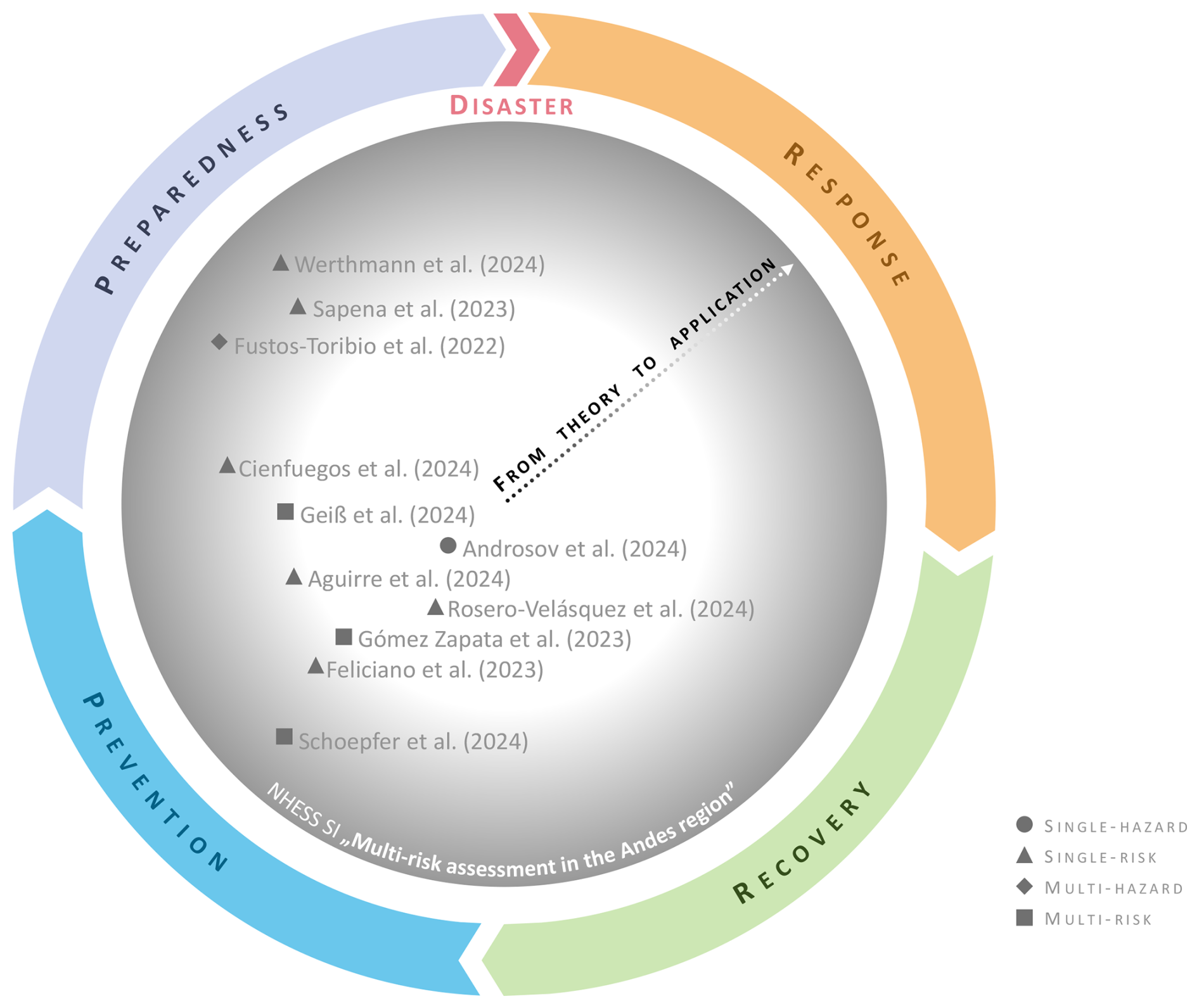
Figure 1Categorization of the 11 papers of this special issue according to their main focus (from theory to application) and approach (from single-hazard to multi-risk assessment), grouped according to the disaster management cycle.
The overall aim of this special issue is to inform the disaster risk community about the latest developments, capabilities, and limitations regarding comprehensive multi-risk assessment with specific focus on applications in Andean countries.
Risk is a function of three factors: hazard, exposure, and vulnerability (UNDRR, 2016). Modelling hazards as the potential source of harm or damage is an essential input to risk assessment. Androsov et al. (2024) contributed with a determination of which factors are crucial for a robust prediction of tsunami hazard by simulations. They performed a comparative analysis of two numerical models (Tsunami-HySEA and TsunAWI) for the calculation of tsunamis triggered by earthquakes off the coast of Peru. In addition to this comparative analysis, the role of nonlinear terms in the numerical solutions was analysed, since tsunami run-up and inundation are highly nonlinear processes. Overall, the authors conclude that nonlinearity is crucial in the estimation of inundated areas, wave heights, and current velocities, as well as in the generation of inundation maps.
When dealing with risks, the use of scenarios to describe possible events and their effects is a common practice in disaster risk management procedures. However, the selection criteria do not always consider the consequences for exposed assets. The following two papers address the analysis of risk scenarios with two different foci: Rosero-Velásquez et al. (2024) devoted their research work to a systematic selection of earthquake scenarios rather than their selection based on expert knowledge or past events. They adopted a definition of a representative scenario, associated with return periods and loss level, for selecting such scenarios among all possible earthquake scenarios. They identified scenarios for residential buildings and power supply facilities in Valparaíso and Viña del Mar, Chile. Potential extensions to this methodology may include catalogues of multiple hazards (for example, earthquake scenarios with tsunamis), loss calculations considering indirect impacts, and high-dimensional scenarios (for example, including damage states of individual components, either buildings or power network components). Feliciano et al. (2023) performed a seismic risk assessment using 18 earthquake scenarios for Sabana Centro Province in Colombia. An exposure model was created by combining information from the Global Earthquake Model (GEM) Foundation, additional surveys, and national census data. Building types in the region were assigned corresponding fragility and vulnerability curves. The OpenQuake (OQ) hazard and risk assessment tool was used to develop a hazard model for the region of interest to estimate damage and economic losses. In addition, a social vulnerability index (SVI) based on demographic information was used to assess direct economic losses in terms of replacement costs. Results show that 10 % of all buildings considered in the region would collapse and 7 % would be severely damaged. The economic losses represent 14 % of the total replacement cost of the buildings and 21 % of the annual gross domestic product (GDP) of the region.
The understanding and inclusion of different urban structures and related vulnerabilities are essential for planning activities and practical applications. The research paper from Aguirre et al. (2024) analysed seven fire case studies in central Chile in order to enhance the understanding of risk profiles in wildland–urban interface (WUI) areas. They developed a mixed-methods approach to conducting local-scale analyses that included field surveys, remote sensing using satellite and drone imagery, and GIS-based analysis of the collected data. This resulted in a geo-referenced database of damaged and un-damaged houses, including 16 variables representing their physical features, spatial location, and availability of firefighting means. A binary classification model was then used to assess the relative importance of these attributes as indicators of vulnerability. The analysis showed that the factors of spatial arrangement have a greater impact on the prediction of damage than the structural conditions and the fire preparedness of the individual units. In particular, factors such as the proximity of the dwelling to neighbours, distance to vegetation, proximity to the boundary of dwelling groups, and distance to the origin of the fire contribute significantly to the prediction of fire damage. Although more data are required to confirm this, other structural characteristics associated with less affluent dwellings may also increase the likelihood of damage. This study has implications for the design, planning, and management of WUI areas in Chile. It can provide support in the development of risk reduction strategies for both built structures and the broader territory. The study from Cienfuegos et al. (2024) carried out a detailed analysis of possible evacuation scenarios, considering the actual state of the evacuation routes of Iquique, a Chilean city at risk of tsunamis. Iquique has a significant number of urban micro-vulnerabilities, i.e. elements that impede or complicate the flow of pedestrians. Micro-scale agent-based model (ABM) simulations were used to quantify the delay in evacuation processes due to the presence of urban micro-vulnerabilities. Furthermore, these results were integrated with high-resolution tsunami inundation simulations. This allowed an estimation of the potential number of people that the tsunami could reach under different scenarios by emulating the dynamics and behaviour of the population and the decision-making regarding the start time of the evacuation.
The previous contributions mentioned so far show the importance of having information on the number of people affected. Geiß et al. (2024) went further and projected future geospatial population distributions to quantify the number of people living in earthquake- and tsunami-prone areas of Lima and Callao, Peru, over a 3-year interval until 2035. The researchers used existing gridded population time series (such as WorldPop) that are available worldwide as open data, and they implemented machine learning models tailored for time series analysis, based on long short-term memory (LSTM) networks. They concluded that areas with high seismic hazard seismicity would see population growth of nearly 30 %. It was estimated that the population in the area endangered by tsunami inundation would increase by more than 60 %. The identification and understanding of these relationships can help urban planners and policy-makers to develop effective risk reduction strategies.
The ultimate and rather complex steps towards multi-risk assessment comprise the consideration of all interactions on the level of vulnerability for multiple and/or cascading hazards. Gómez Zapata et al. (2023) assessed the cumulative damage that would occur if a series of events, such as an earthquake and/or tsunami, occurred in the vicinity of the capital city of Lima, Peru. Their method is based on proposing state-dependent fragility functions for the respective hazard to account for pre-existing damage and on harmonizing building classes and damage states through their taxonomic characterization for the different hazards. The results show that the traditional empirical tsunami fragility functions underestimate the losses for the earthquake- and tsunami-exposed residential buildings in Lima for small-Mw events and overestimate them for large-Mw events.
By integrating these scientific findings from Gómez Zapata et al. (2023) with further research on multi-risk assessment, Schoepfer et al. (2024) have analysed and described approaches to help potential users like disaster risk managers, urban planners, or critical infrastructure operators improve their ability to cope with the increasing complexity of risks. They developed a novel tool using a modular and decentralized system architecture with distributed web services. A user interface allows for the visualization and analysis of various scenarios and their related impacts. During the development process, a strong link with stakeholders and potential users was established. In various iterations, both requirements and feedback were gathered to optimize the interactive tool with regard to its practical applicability. The system components were published on an open-source platform to ensure further development towards an operational system. Exemplified for the study area of the Lima metropolitan area, Peru, the authors conclude that research can significantly contribute to meaningful and effective multi-risk analysis when good cooperation and interaction between authorities, academia, and civil society organizations are established.
Three papers in this special issue have taken the step from prevention to preparedness. They focus on research and development towards prototypical implementation of early warning systems. Fustos-Toribio et al. (2022) developed a rainfall-induced landslide early warning system (RILEWS) for the southern regions of Chile. The preoperational system is based on a logistic model and is forced by the geomorphological and atmospheric conditions in the southern Andes. The authors have shown how the Weather Research and Forecasting (WRF) model can be integrated into the RILEWS operational system without the use of ensembles and using bias correction procedures instead. Their results indicate that bias correction without costly computer iterations is a useful alternative to numerical models. This opens up the path to implementing precipitation-based prediction models without costly computational iterations through ensembles of models. As the developed methodology can be implemented for similar climate zones in different countries and latitudes, this work has high potential for practical implementation.
Werthmann et al. (2024) share insights into the development of a landslide early warning system (LEWS) prototype developed for an informal settlement on the urban–rural border of Medellín, Colombia. A preliminary LEWS has been designed, implemented, and handed over to the government. It has gone through a test and calibration phase (i.e. development of warning thresholds, procedures for the dissemination of warnings and alerts through the sensor system). The authors provide details on the scientific and technical development of this prototype and also on the living-lab experiences and challenges. The authors demonstrate that LEWS can be accurate, affordable, and socially integrated. However, there are several factors that go beyond scientific and technical capabilities – above all, social acceptance and political will. In the same context, Sapena et al. (2023) provide further information on the associated costs for the monitoring instrumentation of the LEWS. They combined data-driven landslide susceptibility mapping and population maps to identify exposed locations. In the research article, the authors estimate the cost of monitoring sensors and the installation of a LEWS with a budget ranging from EUR 5 to 41 per protected inhabitant in Medellín, Colombia, varying based on site-specific characteristics. The information can be seen as a step forward in providing guidance to decision-makers and supporting disaster risk reduction efforts.
The papers in this special issue cover different aspects of the disaster risk management cycle for complex disaster situations. While advanced studies for modelling (single) hazards are still valid and demanding in their nature, involving multi-hazard dependencies, exposure, and dynamic vulnerability in the analysis specifically requires a great deal of research. Beyond this, the contributions reveal that it is of utmost importance to test methods and tools in real-world conditions in order to steadily close the gap between theory and (operational) application.
In summary, the presented research papers clearly demonstrate the importance of not stopping at methodological approaches and research questions but of moving from theory to user involvement and user feedback. Possible bottlenecks only become apparent during the transition from scientific applications to preoperational prototypes.
In all application-oriented projects, close and iterative interdisciplinary collaboration between researchers, developers, and users is an integral part of the entire development phase. If the needs of users are considered from the outset – and this is demonstrated by the contributions – developments are better geared towards practical applicability and contribute to solving current problems. It must be ensured that the information meets the needs of the users and is understandable even without specialized knowledge. It should be noted that users are particularly interested in results that show the possible impacts of the situations in question.
These studies clearly demonstrate the breadth of the subject area, and they also highlight the complexity throughout the risk cycle in the respective topics – methodologically, thematically, and in terms of accuracy and uncertainties as well as, of course, the challenge in moving from science to practice.
Publisher’s note: Copernicus Publications remains neutral with regard to jurisdictional claims made in the text, published maps, institutional affiliations, or any other geographical representation in this paper. While Copernicus Publications makes every effort to include appropriate place names, the final responsibility lies with the authors.
We are very grateful to all the authors and reviewers for their contributions to this special issue.
Parts of the research articles were funded by the German Federal Ministry of Education and Research (BMBF) as part of the German initiative “CLIENT II – International Partnerships for Sustainable Innovations” within the framework programme “Research for Sustainable Development (FONA)”, e.g. grant no. 03G0876A-J (project RIESGOS) and grant no. 03G0905A-H (project RIESGOS 2.0).
Aguirre, P., León, J., González-Mathiesen, C., Román, R., Penas, M., and Ogueda, A.: Modelling the vulnerability of urban settings to wildland–urban interface fires in Chile, Nat. Hazards Earth Syst. Sci., 24, 1521–1537, https://doi.org/10.5194/nhess-24-1521-2024, 2024.
Androsov, A., Harig, S., Zamora, N., Knauer, K., and Rakowsky, N.: Nonlinear processes in tsunami simulations for the Peruvian coast with focus on Lima and Callao, Nat. Hazards Earth Syst. Sci., 24, 1635–1656, https://doi.org/10.5194/nhess-24-1635-2024, 2024.
Bündnis Entwicklung Hilft/IFHV: WeltRisikoBericht 2023, Bündnis Entwicklung Hilft, Berlin, ISBN 978-3-946785-15-6, 2023.
Cienfuegos, R., Álvarez, G., León, J., Urrutia, A., and Castro, S.: Analysis of the effects of urban micro-scale vulnerabilities on tsunami evacuation using an agent-based model – case study in the city of Iquique, Chile, Nat. Hazards Earth Syst. Sci., 24, 1485–1500, https://doi.org/10.5194/nhess-24-1485-2024, 2024.
Feliciano, D., Arroyo, O., Cabrera, T., Contreras, D., Valcárcel Torres, J. A., and Gómez Zapata, J. C.: Seismic risk scenarios for the residential buildings in the Sabana Centro province in Colombia, Nat. Hazards Earth Syst. Sci., 23, 1863–1890, https://doi.org/10.5194/nhess-23-1863-2023, 2023.
Fustos-Toribio, I., Manque-Roa, N., Vásquez Antipan, D., Hermosilla Sotomayor, M., and Letelier Gonzalez, V.: Rainfall-induced landslide early warning system based on corrected mesoscale numerical models: an application for the southern Andes, Nat. Hazards Earth Syst. Sci., 22, 2169–2183, https://doi.org/10.5194/nhess-22-2169-2022, 2022.
Geiß, C., Maier, J., So, E., Schoepfer, E., Harig, S., Gómez Zapata, J. C., and Zhu, Y.: Anticipating a risky future: long short-term memory (LSTM) models for spatiotemporal extrapolation of population data in areas prone to earthquakes and tsunamis in Lima, Peru, Nat. Hazards Earth Syst. Sci., 24, 1051–1064, https://doi.org/10.5194/nhess-24-1051-2024, 2024.
Gómez Zapata, J. C., Pittore, M., Brinckmann, N., Lizarazo-Marriaga, J., Medina, S., Tarque, N., and Cotton, F.: Scenario-based multi-risk assessment from existing single-hazard vulnerability models. An application to consecutive earthquakes and tsunamis in Lima, Peru, Nat. Hazards Earth Syst. Sci., 23, 2203–2228, https://doi.org/10.5194/nhess-23-2203-2023, 2023.
Greiving, S., Fleischhauer, M., León, C. D., Schödl, L., Wachinger, G., Quintana Miralles, I. K., and Prado Larraín, B.: Participatory Assessment of Multi Risks in Urban Regions – The Case of Critical Infrastructures in Metropolitan Lima, Sustainability, 13, 2813, https://doi.org/10.3390/su13052813, 2021.
Kruse, P. M., Schmitt, H. C., and Greiving, S.: Systemic criticality – a new assessment concept improving the evidence basis for CI protection, Climatic Change, 165, 2, https://doi.org/10.1007/s10584-021-03019-x, 2021.
Munich Re: Natural disaster risks – Rising trend in losses, https://www.munichre.com/en/risks/natural-disasters.html (last access: 3 June 2024), 2023.
Munich Re: Record thunderstorm losses and deadly earthquakes: the natural disasters of 2023, https://www.munichre.com/en/company/media-relations/media- information-and-corporate-news/media-information/2024/ natural-disaster-figures-2023.html (last access: 19 December 2024), 2024.
Rosero-Velásquez, H., Monsalve, M., Gómez Zapata, J. C., Ferrario, E., Poulos, A., de la Llera, J. C., and Straub, D.: Risk-informed representative earthquake scenarios for Valparaíso and Viña del Mar, Chile, Nat. Hazards Earth Syst. Sci., 24, 2667–2687, https://doi.org/10.5194/nhess-24-2667-2024, 2024.
Sapena, M., Gamperl, M., Kühnl, M., Garcia-Londoño, C., Singer, J., and Taubenböck, H.: Cost estimation for the monitoring instrumentation of landslide early warning systems, Nat. Hazards Earth Syst. Sci., 23, 3913–3930, https://doi.org/10.5194/nhess-23-3913-2023, 2023.
Schoepfer, E., Lauterjung, J., Riedlinger, T., Spahn, H., Gómez Zapata, J. C., León, C. D., Rosero-Velásquez, H., Harig, S., Langbein, M., Brinckmann, N., Strunz, G., Geiß, C., and Taubenböck, H.: Between global risk reduction goals, scientific–technical capabilities and local realities: a modular approach for user-centric multi-risk assessment, Nat. Hazards Earth Syst. Sci., 24, 4631–4660, https://doi.org/10.5194/nhess-24-4631-2024, 2024.
Taubenböck, H., Mast, J., Geiß, C., Wurm, M., Esch, T., and Seto, K. C.: Global differences in urbanization dynamics from 1985 to 2015 and outlook considering IPCC climate scenarios, Cities, 151, 105117, https://doi.org/10.1016/j.cities.2024.105117, 2024.
UNDESA: World Population Prospects 2022, https://www.un.org/development/desa/pd/content/World-Popula tion-Prospects-2022 (last access: 19 December 2024), 2022.
UNDRR (United Nations Office for Disaster Risk Reduction): The disaster risk reduction (DRR) glossary, UNDRR, https://www.undrr.org/terminology/hazard (last access: 19 December 2024), 2016.
UNDRR (United Nations Office for Disaster Risk Reduction): Projecting Effects of Climate Change in the framework of the INFORM Risk Index, UNDRR, https://www.undrr.org/media/80490 (last access: 13 March 2025), 2022.
UNDRR (United Nations Office for Disaster Risk Reduction): The UNDRR Stakeholder Engagement Mechanism (SEM) Action Plan 2024–2025, https://www.preventionweb.net/publication/ undrr-stakeholder-engagement-mechanism-sem-action-plan-2024-2025 (last access: 3 June 2024), 2024.
UNISDR: Sendai Framework for Disaster Risk Reduction 2015–2030, UNISDR, Geneva, https://www.undrr.org/media/16176 (last access: 13 March 2025), 2015.
Werthmann, C., Sapena, M., Kühnl, M., Singer, J., Garcia, C., Breuninger, T., Gamperl, M., Menschik, B., Schäfer, H., Schröck, S., Seiler, L., Thuro, K., and Taubenböck, H.: Insights into the development of a landslide early warning system prototype in an informal settlement: the case of Bello Oriente in Medellín, Colombia, Nat. Hazards Earth Syst. Sci., 24, 1843–1870, https://doi.org/10.5194/nhess-24-1843-2024, 2024.
World Meteorological Organization (WMO): State of the Climate in Latin America and the Caribbean 2023, WMO-No. 1351, 42 pp., ISBN 978-92-63-11351-1, https://library.wmo.int/idurl/4/68891 (last access: 19 December 2024), 2024.
Zschau, J.: Where are we with multihazards, multirisks assessment capacities?, in: Science for disaster risk management 2017: knowing better and losing less, edited by: Poljansek, K., Marin Ferrer, M., De Groeve, T., and Clark, I., European Union, 98–115, https://doi.org/10.2788/688605, 2017.