the Creative Commons Attribution 4.0 License.
the Creative Commons Attribution 4.0 License.
 | 12 May 2023
A web-based GIS (web-GIS) database of the scientific articles on earthquake-triggered landslides
Mauro Rossi
Federica Polpetta
Federica Fiorucci
Carolina Fortunato
Paola Reichenbach
Over the last 2 decades, the topic of earthquake-triggered landslides (EQTLs) has shown increasing relevance in the scientific community. This interest is confirmed by the numerous articles published in international, peer-reviewed journals. In this work we present a database containing a selection of articles published on this topic from 1984 to 2021. The articles were selected through a systematic search on the Clarivate™ Web of Science™ Core Collection online platform and were catalogued into a web-based GIS (web-GIS), which was specifically designed to show different types of information. After a general analysis of the database, for each article the following aspects were identified: the bibliometric information (e.g. author(s), title, publication year), the relevant topic and sub-topic category (or categories), and the earthquake(s) addressed. The analysis allowed us to infer general information and statistics on EQTLs (e.g. relevant methodological approaches over time and in relation to the scale of investigation, most studied events), which can be useful to obtain a spatial distribution of the articles and a general overview of the topic.
- Article
(4517 KB) - Full-text XML
-
Supplement
(459 KB) - BibTeX
- EndNote


Earthquakes are one of the most threatening and devastating natural hazards worldwide and cause significant loss of life and damage to human structures and infrastructures. Although most of the damage is related to the partial or full collapse of buildings caused by ground shaking, in many cases other ground effects (e.g. tsunamis, liquefaction, landslides) can significantly increase the impact of the seismic event (e.g. Jibson and Harp, 2012). In particular, earthquake-triggered landslides (EQTLs, also “co-seismic landslides”) are responsible for approximately 70 % of all earthquake-related fatalities not directly caused by ground shaking (Marano et al., 2010). Casualties caused by EQTLs are generally related to the collapse of buildings induced by downslope movements, which frequently tends to cover up previous structural damage caused by seismic shaking (Bird and Bommer, 2004). EQTLs often interrupt road networks and other transportation infrastructures, hampering rescue, supply, and recovery activities (Allstadt et al., 2022). EQTLs can also partly or completely block river channels, inducing downstream floods (e.g. Fan et al., 2012) and, in the long-term, causing changes to the drainage-basin characteristics (Keefer, 1999). For all these reasons, EQTLs are an important component of natural hazard assessment in seismically active areas, and in recent years the study of collateral seismic hazards has become an issue of increasing relevance (Wasowski et al., 2011), also in the framework of multi-risk assessments, accounting for potential cascading effects.
In this article we describe the results of a systematic search of scientific papers concerning EQTLs published in peer-reviewed international journals in the past decades. Searching on the Clarivate™ Web of Science™ Core Collection online platform, we have collected 810 articles which were organized in a specific web-based GIS (web-GIS) database for the analysis. The identified articles deal with EQTL themes from numerous points of view, focusing on a wide range of aspects, such as spatial distribution in relation to earthquake location, triggering and propagation mechanisms, or impact on human activities. The aim of this work is to provide a tool which shows the geographical distribution of the articles published on this topic classified using different types of information, which may represent a starting point for future analyses. The paper is organized as follows: Sect. 2 describes the structure of the database, Sect. 3 discusses the type of information addressed by the articles, and Sect. 4 summarizes some main conclusions.
The EQTL literature database was implemented starting from the identification of the articles published in international, peer-reviewed journals. The literature search was performed using Clarivate™ Web of Science™ Core Collection (WoSCC) online platform, which is made up of more than 21 000 peer-reviewed journals worldwide (Web of Science Group, 2021). In this respect, other sources of information are freely available online, such as the ISC Event Bibliography (http://www.isc.ac.uk/event_bibliography/index.php, last access: 7 January 2023), which is a database containing publications about not only seismology but also other types of topics related to specific earthquakes, including landslides (Di Giacomo et al., 2014). However, since we focused exclusively on EQTLs, we used as search parameters on WoSCC a combination of significant keywords (e.g. landslide, slope failure, earthquake, seismic, triggered, induced) and Boolean search criteria applied to the “title”, “abstract”, and “keywords” of the articles (Reichenbach et al., 2018). A total of 810 articles published from April 1984 to February 2021 were collected and organized in the database. Each publication was verified to check its relevance for the topic of EQTLs. In most cases, it was sufficient to read the title and the abstract to verify whether an article was relevant for our purpose, but to prepare the final version of the database, it was necessary to double-check the articles to reduce potential mistakes.
2.1 Data categories
Based on our experience and after a preliminary reading of approximately 10 % of the articles, we identified a set of information that we consider significant for the analysis. We selected three major data categories (i.e. article information, article topic, and earthquake information) further divided into sub-categories (Table 1).
Table 1Summary statistics of the categories and sub-categories used in the database. The column “Counts” provides the number of occurrences as given by the authors, when applicable. MCS denotes “Mercalli–Cancani–Sieberg”. The earthquake catalogues are referenced in the text (Sect. 2.1.3).

2.1.1 Article information
In the database, the information defined for each article is the following: publication year (B1), author(s) (B2), article title (B3), and journal name (B4). The first article of our search was published in April 1984 (Keefer, 1984), and only 20 articles had been published on the topic until 1999 (Fig. 1). An increasing trend of the number of published articles can be noted in the following years, particularly from the late 2000s, with a peak in 2019 and 2020 (99 and 100 articles, respectively).
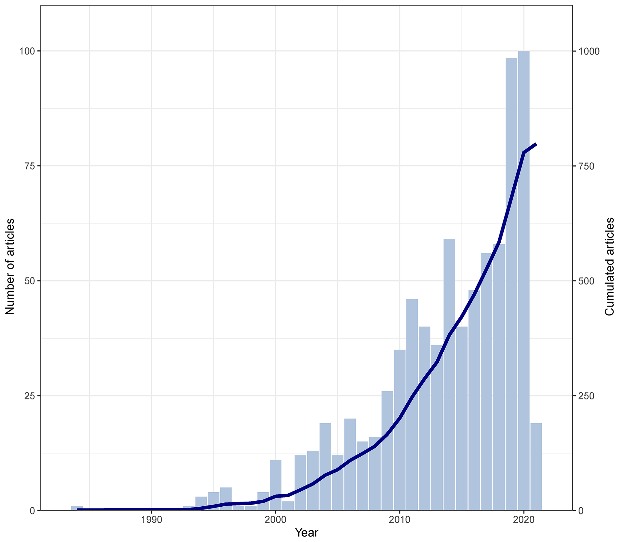
Figure 1Analysis of the literature database listing 810 articles in the 37-year period from April 1984 to February 2021. The source of the article search was the Web of Science™ (formerly a Thomson Reuters™ product, now part of Clarivate™). The graph shows the number of articles per year (vertical blue bars, left y axis) and their cumulated number (solid blue line, right y axis).
The 810 identified papers were published in 160 different peer-reviewed journals. The Geological Society of America Bulletin has published the lowest number of articles but for the longest period, considering that the first article and last article were published in 1984 and 2020, respectively (Fig. 2). Engineering Geology, Landslides, and Geomorphology have published the largest number of articles (i.e. 233, which represents 28.8 % of the total), covering a period from the mid-1990s–early 2000s until February 2021. Natural Hazards, Journal of Mountain Science, and Bulletin of the Engineering Geology and the Environment have published 105 papers (13.0 % of the total), while Natural Hazards and Earth System Sciences, Bulletin of the Seismological Society of America, Environmental Earth Sciences, Soil Dynamics and Earthquake Engineering, and Geosciences have published 118 papers (14.6 % of the total). It is worth noting that Geosciences has published the largest annual number of papers with 14 articles in a little more than 3 years (2018–February 2021).

Figure 2Ranking of top journals in terms of number of articles published on EQTLs, according to the literature database. The number of published articles is reported in brackets next to the journal name. The colour of horizontal bars indicates the number of articles in six classes.
Overall, 56.4 % of the articles in the literature database were published in the above-mentioned 11 journals, whose scopes include the analysis of natural hazards, geological and/or geotechnical engineering, and geomorphology. Among these journals, only two (Bulletin of the Seismological Society of America and Soil Dynamics and Earthquake Engineering) specifically deal with seismology and earthquake engineering.
The analysis of the database revealed that the average number of authors for each paper varied over the years. Excluding the first article by Keefer (1984), the papers published before 2000 were written, on average, by two to three authors. In more recent years, the number increased to four to five authors, which suggests a need for different expertise to perform the wide range of research activities related to EQTLs.
2.1.2 Article topic
The articles collected in the database were classified into four categories considering the following main topics:
-
regional landslide analysis – articles focusing on the analysis of EQTLs over large areas;
-
single-landslide analysis – articles focusing on the analysis of single mass movements;
-
other – articles presenting various types of research activities related to EQTLs, such as data presentation (e.g. Fortunato et al., 2012; Tanyaş et al., 2017; Villani et al., 2018; Rodríguez-Peces et al., 2020) and synthesis of historical information and review articles (e.g. Keefer, 1984, 2002; Bird and Bommer, 2004; Wasowski et al., 2011; Fan et al., 2019);
-
not applicable – articles on topics only partially related to EQTLs (see Sect. 3.1.3).
The articles included in the “regional landslide analysis” and “single-landslide analysis” categories were further subdivided in sub-topics that characterize different aspects of the main research activity described in the paper (such as mapping, characterization, modelling). In many cases more than one sub-topic has been attributed to a single article. For the regional landslide analysis the sub-topics can be summarized as follows:
-
regional mapping – recognition of the spatial distribution of EQTLs;
-
regional landslide descriptive statistics – statistical analysis of the main physical and geometrical features of EQTLs (e.g. number, extension, volume, run-out, type of movement, involved material);
-
regional susceptibility/hazard assessment – modelling and zonation of susceptibility/hazard scenarios for EQTLs;
-
regional risk modelling – assessment of the effects on human activities of EQTLs occurring over large areas;
-
regional landslide comparison – analysis focused on the comparison between different landslide inventory maps, with the aim of evaluating general rules about earthquake-induced landslide occurrence.
For the single-landslide analysis, the sub-topics are as follows:
-
single-failure mapping – reconstruction of the surficial geometry;
-
single-failure geotechnical characterization – definition and description of the geotechnical parameters;
-
single-failure geophysical characterization – definition and description of specific parameters, which can be assessed using geophysical investigations (e.g. stiffness, shear modulus, moisture conditions);
-
single-failure modelling – reconstruction of single-landslide events triggered by earthquakes;
-
single-failure impact/risk modelling – analysis focused on the assessment of the effects induced by a single EQTL on human activities (e.g. damaging of buildings);
-
single-landslide comparison – analysis focused on the comparison between single landslides triggered by earthquakes.
2.1.3 Earthquake information
The 810 identified papers describe ground effects related to 136 earthquakes. For each earthquake we collected a set of data using the ANSS Comprehensive Earthquake Catalog (ComCat), implemented by USGS (http://earthquake.usgs.gov/earthquakes/search/, last access: 1 October 2022) as the main source of information. In the catalogue, the available information depends on the date of occurrence. For earthquakes that occurred before 1900 (18 events), it was possible to attribute only a broad localization of the epicentre, an estimation of the date of occurrence, and the macroseismic intensity, which allows us to quantify the shaking level from observations of the effects on buildings, environment, and people (Masi et al., 2020). For earthquakes that occurred after 1900, it was instead possible to obtain more detailed information and it was possible to associate with each seismic event the data listed in Table 1: earthquake ID (D1), the name (D2), the time of occurrence (D3) in the format yy-mm-dd-hh:mm-ss UTC (coordinated universal time), and the country of occurrence (D4). A distinction was made between single and multiple events (D5): an earthquake was considered multiple when the seismicity near the main shock was characterized by at least 10 events with Mw (moment magnitude) ≥ 5. In the database we have also indicated the focal mechanism (D6). Specifically, the main deformation style of the earthquake-generating fault was defined using the Kaverina-type double-couple (DC) classification diagram (Kaverina et al., 1996), which considers seven different fault mechanisms: normal, normal–strike-slip, reverse, reverse–strike-slip, strike-slip, strike-slip–normal, and strike-slip–reverse. From the Global Centroid Moment Tensor Catalogue (GCMTC) (https://www.globalcmt.org/, last access: 1 October 2022), we retrieved the moment tensor solution (D7) for 97 out of 136 investigated earthquakes. We used the moment tensor solution as input for the FMC software (Álvarez-Gómez, 2019), which allows us to automatically generate a Kaverina-type DC classification diagram. In the cases where the moment tensor solution was missing, we defined the focal mechanism from the specific literature if available (D8). The different types of magnitude, i.e. ML – Richter local magnitude (D9), Ms – Richter surface-wave magnitude (D10), Mw – moment magnitude (D11), and the Mercalli–Cancani–Sieberg (MCS) intensity scale (D12), were also added into the database, together with the epicentre coordinates (latitude – D13 and longitude – D14) and the hypocentre depth (D15). For each record, we specified the source of information (D16). As mentioned above, most of the information is derived from the ANSS catalogue, but for several historical earthquakes, we used the National Centers for Environmental Information World Data System (NCEI WDS) Global significant Earthquake Database (https://www.ngdc.noaa.gov/hazel/view/hazards/earthquake/search, last access: 1 October 2022), which includes over 5700 earthquakes from 2150 BCE to the present.
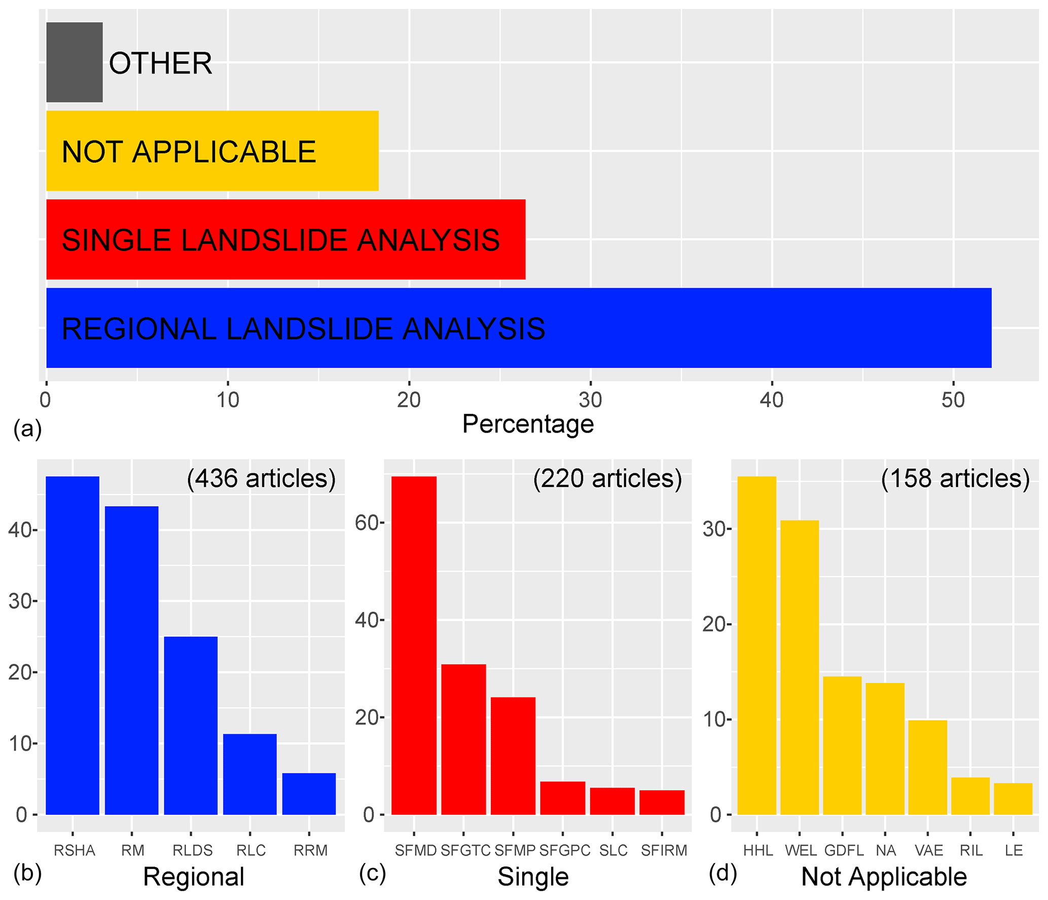
Figure 3Percentage of articles with respect to the main topics (a) and sub-topics for the regional landslide analysis (b), single-landslide analysis (c), and not applicable (d) categories. The percentage is calculated with respect to the total number of articles included in the considered category (in brackets). RSHA: regional susceptibility/hazard assessment; RM: regional mapping; RLDS: regional landslide descriptive statistics; RLC: regional landslide comparison; RRM: regional risk modelling; SFMD: single-failure modelling; SFGTC: single-failure geotechnical characterization; SFMP: single-failure mapping; SFGPC: single-failure geophysical characterization; SLC: single-landslide comparison; SFIRM: single-failure impact/risk modelling; HHL: historical/Holocene landslides; WEL: water environment landslides; GDFL: ground deformation, failure, and liquefaction processes; NA: not applicable; VAE: vegetation and EQTLs; RIL: rainfall-induced landslides; LE: landscape evolution.
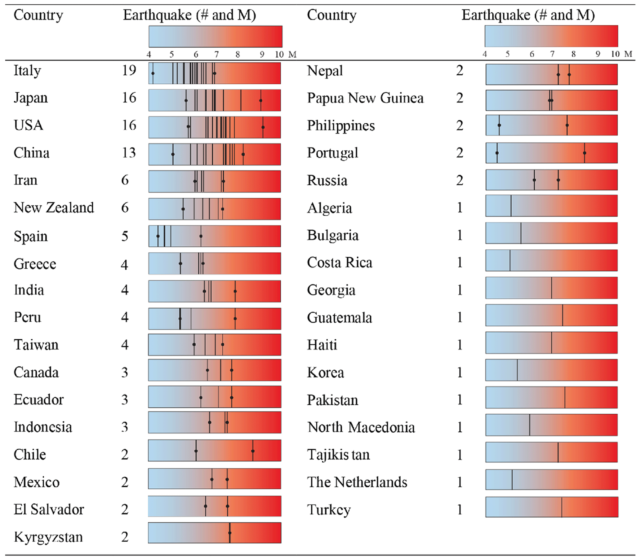
Figure 4Number of earthquakes listed in the database for each country. The magnitude of each event is reported in the coloured bar. For each country, the lines with the black dot show the first and the last earthquake.
2.2 Structure and features of the web-GIS database
A dedicated web-GIS (http://194.119.218.119/it/map/a-web-gis-database-of-the-scientific-articles-on-e/qdjango/54/, last access: 1 January 2023) was implemented to manage and consult the articles where geographical data (i.e. country and/or earthquake information) are available.
The web-GIS was implemented using G3W-SUITE (https://g3wsuite.it/en/g3w-suite-publish-qgis-projects/, last access: 1 January 2023), a modular client–server application that fully integrates the QGIS Python application programming interface (API) and allows us to publish and manage QGIS cartographic projects. The web-GIS contains two geographic layers and two tables. The first geographical layer refers to the earthquakes, which are located according to their epicentre (latitude – D13 and longitude – D14); the second refers to the countries based on the “world_boundaries” shapefile (https://public.opendatasoft.com/explore/dataset/world-administrative-boundaries/export, last access: 1 January 2023). The two tables (“articles_earthquake” and “articles_country”) are associated with the corresponding geographic layers through a one-to-many relationship.
The web-GIS has a user-friendly interface consisting of different panels. In the left panel it is possible to explore and use the following information and tools:
-
metadata – general information on the web-GIS;
-
charts – two different graphs showing the number of articles per country and number of articles per earthquake;
-
search – a search tool which allows us to perform alphanumeric searches on the available layers (i.e. earthquake and world_boundaries);
-
Web Map Service (WMS) – where the user can customize the view using WMS services;
-
map – containing a list of the available layers (i.e. articles_earthquake, earthquake, articles_country, world_boundaries) and the corresponding legends (by right-clicking on the name of each layer, it is possible to visualize the attribute table).
In the right panel there are commands for zooming in and out, measuring distances and areas, and uploading new layers, as well as a snapshot tool. In this panel, the user can also raise queries (selecting the “i” icon) on specific earthquakes or countries and visualize the main associated information.
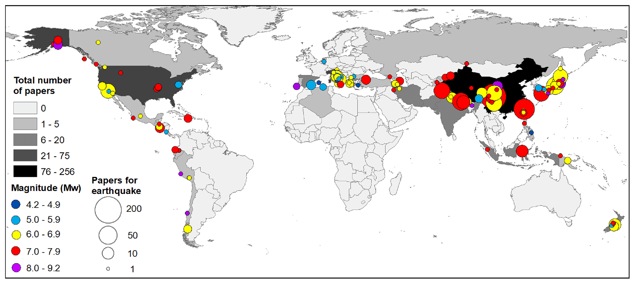
Figure 5Spatial distribution of the 136 earthquakes identified in the literature search. Colour indicates the magnitude, while the size of the circle is proportional to the number of articles dealing with each seismic event. Countries are classified based on the number of articles collected in the database.
In the following sub-sections, we present and discuss a preliminary analysis on the main topics and sub-topics (Sect. 3.1) and on the earthquakes addressed and described in the articles (Sect. 3.2). In addition, in Sect. 3.3 we have evaluated the information on the topics addressed and the listed earthquakes for inferring general and specific aspects of the EQTL scientific literature.
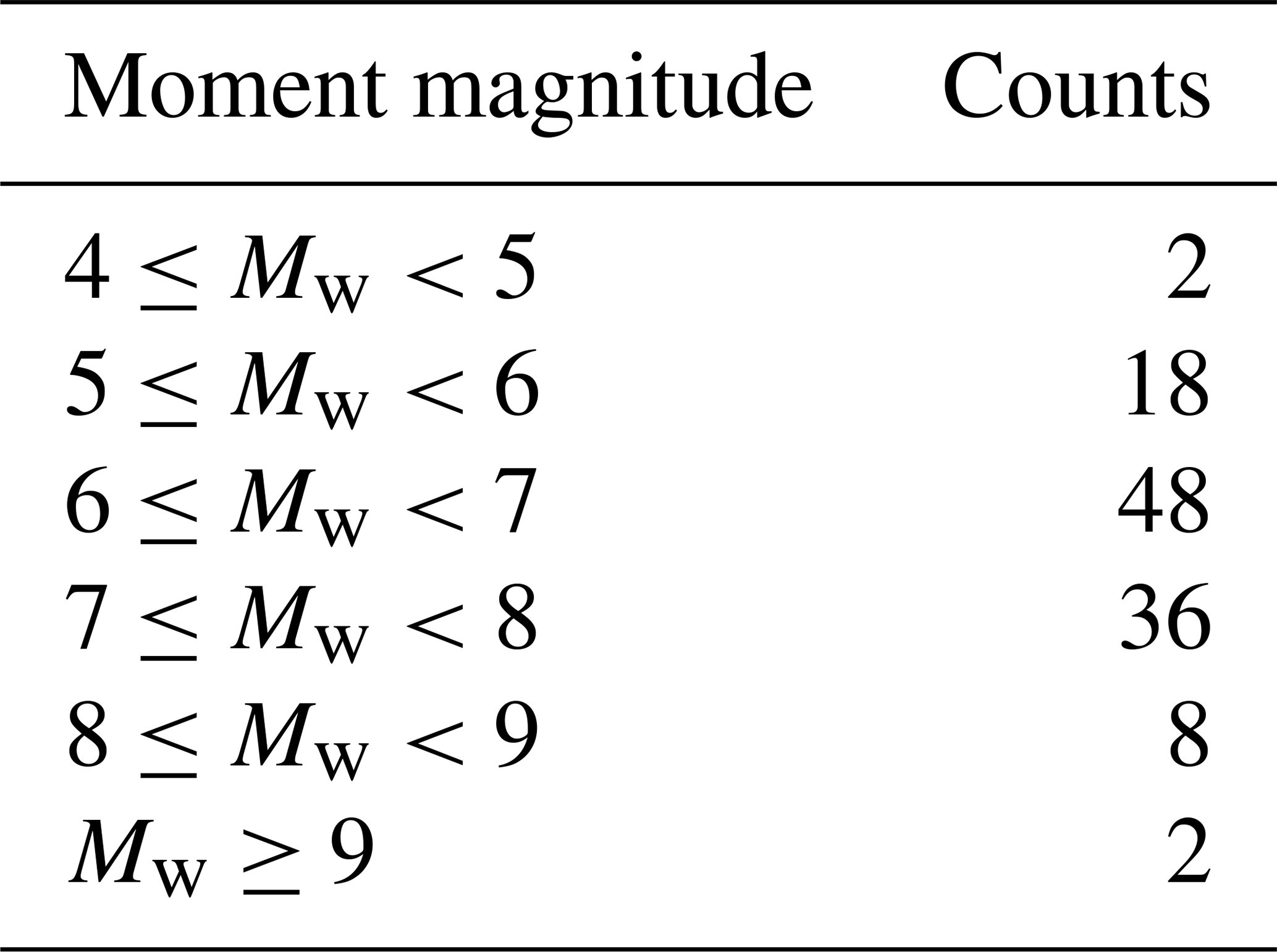
Table 2Number of earthquakes identified for different intervals of moment magnitude (Mw).
3.1 Analysis of article topic
The preliminary analysis of the articles included in the database allowed us to recognize different themes and commonalities and to group them according to main topics and sub-topics (see Sect. 2.1.2). In many cases, we assigned more than one main topic and/or sub-topic to a single article in relation to the variety of the analyses and activities performed.
As regards the main topics, Fig. 3a reveals that the most represented category is regional landslide analysis, with more than half (53.8 %) of the articles, followed by single-landslide analysis (27.2 %), not applicable (19.5 %), and other (3.4 %).
3.1.1 Regional landslide analysis category
The two most numerous sub-categories in the regional landslide analysis category (Fig. 3b) include articles which discuss “regional susceptibility/hazard assessment” (RSHA) analyses and “regional mapping” (RM) activities (47.0 % and 43.8 %, respectively). The third sub-category (“regional landslide descriptive statistics” – RLDS) presents statistical descriptions of EQTLs data and contains about a quarter of the articles (25.2 %). Two further sub-categories discuss “regional landslide comparison” (RLC) and “regional risk modelling” (RRM) and contain only few articles (11.9 % and 5.7 %, respectively).
In the sub-category RSHA (205 articles), many of the articles use and describe modified versions of the Newmark (1965) model (e.g. Jin et al., 2019) or statistical methods such as logistic regression (e.g. Polykretis et al., 2019), artificial neural networks (e.g. Tian et al., 2019), or fuzzy logic (e.g. Razifard et al., 2019). In the set of articles that introduce modified versions of the Newmark model, the EQTL scenario related to a specific seismic event usually implies the exceedance of pre-established co-seismic displacement thresholds (Romeo, 2000), while in the group of statistical models, the outcome generally consists in susceptibility maps resulting from the weighting of different environmental factors (e.g. slope angle, geology, vegetation cover, ground shaking intensity). In both cases the analysis of the EQTL phenomenon concerns almost exclusively the triggering stage, while propagation and deposition processes are seldom examined (e.g. Guo et al., 2014). In addition, no specific methodological variations are presented with respect to the investigated landslide type (e.g. rockfall, earthflows).
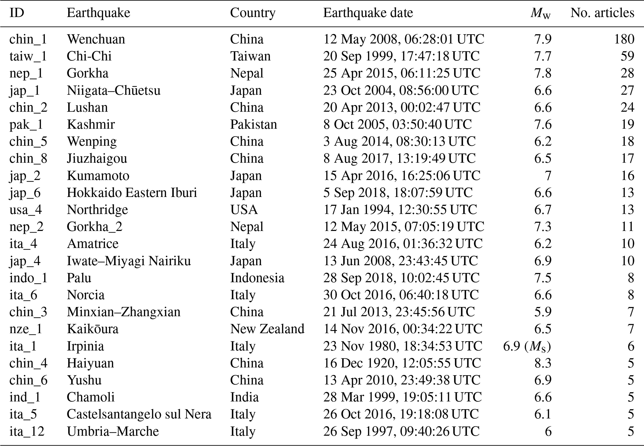
Table 3List of the main characteristics of the earthquakes analysed in more than five articles.
The high number of papers included in the RM sub-category (191 articles) highlights the importance of landslide inventories for analyses over large areas. In this respect, it is important to point out the presence of different online catalogues which report information on EQTLs for recent and historical earthquakes. At a global scale, it is worth mentioning the Open Repository of Earthquake-Triggered Ground-Failure Inventories (Tanyas et al., 2017), which reports EQTLs and liquefaction effect data for 363 earthquakes, or the Earthquake Environmental Effects Catalogue (Guerrieri et al., 2015), which collects information about environmental effects triggered by specific seismic events, whose intensity is expressed according to the ESI (Environmental Seismic Intensity) scale (Michetti et al., 2007).
Of the 191 RM articles, 81 can also be classified within the third sub-category RLDS, since they include not only a description of one or more EQTL inventories but also a statistical analysis of the features of the mapped landslides (e.g. Roback et al., 2018). Conversely, 66 other RM articles are exclusively focused on mapping procedures, which are performed with different methods and techniques such as field investigation (e.g. Martino et al., 2017), analysis of aerial imagery (e.g. Saito et al., 2018), and satellite data (e.g. Hu et al., 2019).
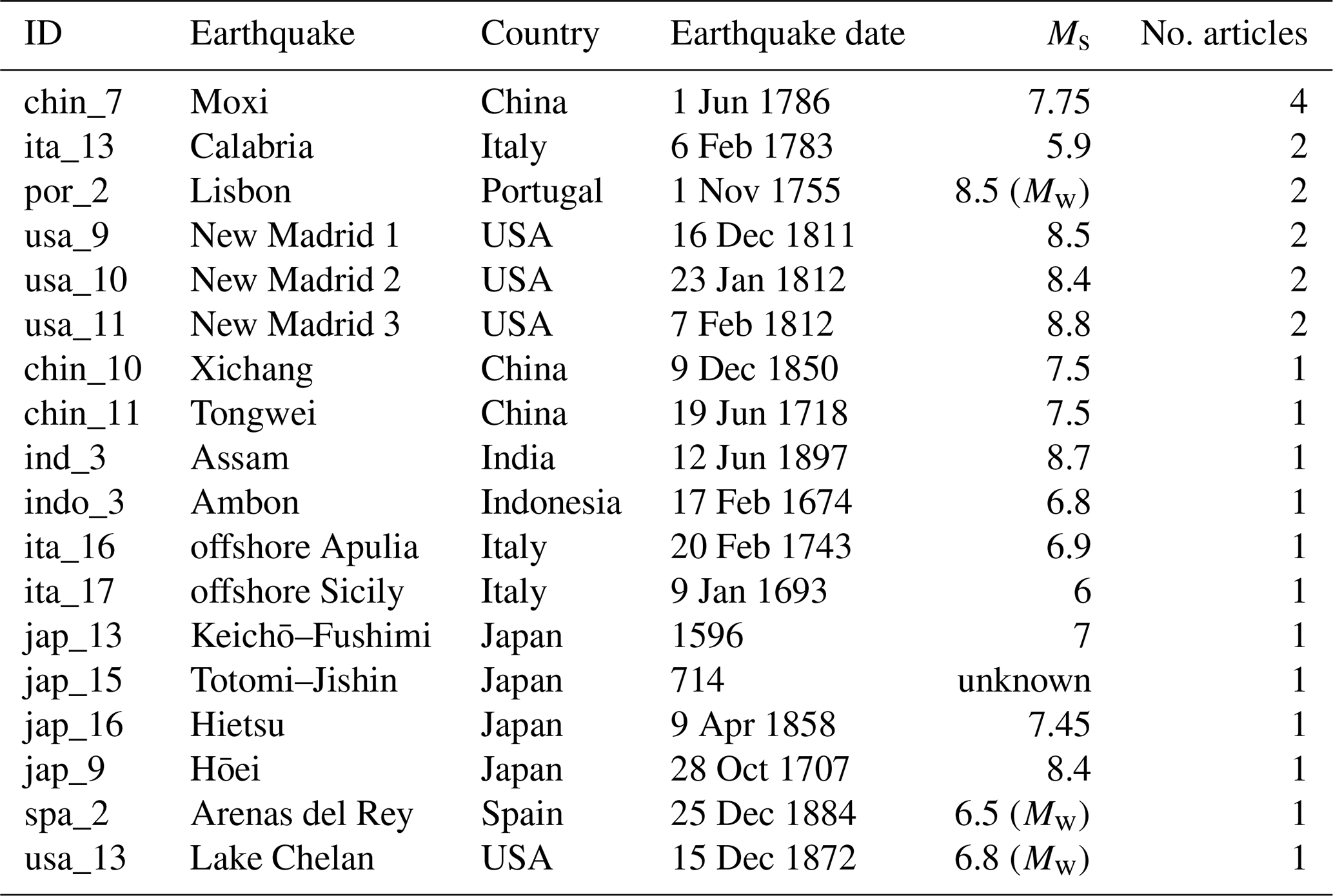
Table 4List of historical earthquakes collected in the database.
As regards the RLC and RRM sub-categories, the relatively low number of articles (52 and 25, respectively) suggests the high specificity of the themes. In the first case, the comparison between landslide inventories can be performed for evaluating potential differences among earthquakes occurring in the same area (e.g. Jibson et al., 2020) or for inferring general rules (Tanyaş and Lombardo, 2020) and/or correlations, e.g. magnitude vs. affected area (e.g. Marc et al., 2017) or ground motion vs. landslide size (e.g. Jibson and Tanyaş, 2020). In the case of RRM articles, the analyses are focused on specific anthropic elements such as buildings, roads, and railways (e.g. Vega and Hidalgo, 2016) or can be framed within a wider risk assessment (e.g. Martino et al., 2020).
3.1.2 Single-landslide analysis category
The largest number of articles (153 out of 220) within the single-landslide analysis category (Fig. 3c) is included in the “single-failure modelling” (SFMD) group. These articles thoroughly investigate the triggering (e.g. Zhang et al., 2018) and/or the propagation process (e.g. Li et al., 2017) of single-landslide events induced by specific seismic inputs. Although different types of approaches have been proposed by the authors, e.g. laboratory experimental testing (e.g. Pu et al., 2020), numerical modelling still represents the most widely used technique. Over the years, numerous types of increasingly sophisticated models have been developed (Jibson, 2011), which have allowed the simulation of complex physical processes related to EQTLs, for example progressive slope failure induced by strain-softening behaviour (e.g. Islam et al., 2019), dynamic fragmentation (e.g. Zhao and Crosta, 2018), and pore-water pressure variation on the sliding surface (Huang et al., 2019).
The SFMD sub-category also comprises 39 out of 68 articles included in the second sub-category (“single-failure geotechnical characterization” – SFGTC). In fact, numerical modelling often requires a detailed definition of the geotechnical parameters of the landslide body, which can be measured directly in the field (e.g. Gratchev and Towhata, 2010) or estimated through laboratory tests and parametric analyses (e.g. Dang et al., 2016). It is important to specify that, in many cases, the authors defined the input parameters of the numerical model simply based on literature values referring to the same or a similar landslide event (e.g. Nian et al., 2020).
Similarly, as described for regional scale, “single-failure mapping” (SFMP) sub-category includes all those articles dealing with mapping of a single-landslide body (e.g. Bozzano et al., 2008). Within this sub-category it is also possible to find almost all the articles belonging to the single-failure geophysical characterization (SFGPC). This point suggests how geophysical investigations are often associated with the detailed reconstruction of the geometry of the landslide (e.g. Havenith et al., 2002).
As regards “single-landslide comparison” (SLC) and “single-failure impact/risk modelling” (SFIRM), we identified a relatively low number of articles (12 and 11, respectively), as in the case of regional-scale analyses. In the first instance, the comparison concerns landslides that occurred during the same earthquake (e.g. Nakamura et al., 2014) or in response to other events that occurred in different regions (e.g. Aydan, 2016). In SFIRM articles, the effects of an EQTL on human activities can be estimated after a specific event (ex post assessment, e.g. Cui et al., 2012) or a priori through the reconstruction of specific single-landslide risk scenarios (e.g. Mousavi et al., 2011).
3.1.3 Not applicable category
As mentioned above, the category “not applicable” contains articles which address and discuss themes only partially related to EQTLs. Considering the not negligible number of articles (158), we performed their analysis and evaluation. On the contrary, we decided to disregard the “other” category, since the low number of articles (28) did not allow us to infer general aspects and significant commonalities.
The examination of the articles classified as not applicable led us to identify different sub-categories (Fig. 3d). The most numerous (“historical/Holocene landslides” – HHL) contains 53 articles (33.5 %) dealing with landslides that occurred in historical times (i.e. before 1900) and, more generally, during the Holocene. In the case of historical failures, only generic information about the triggering earthquake is available, while in the second one (landslides that occurred during the Holocene), it is often difficult to recognize with certainty the earthquake as a triggering factor. In these articles, the authors often use terms that refer to the possible nature of the landslide trigger, such as “was probably triggered” (Pérez-López et al., 2019) or “most likely triggered” (Lv et al., 2014). In this group, several authors also describe dating techniques, such as dendrochronological (e.g. Struble et al., 2020), lichenometric (e.g. Pérez-López et al., 2019), and isotopic analyses (e.g. Kojima et al., 2014). For landslide events that occurred in historical times, archival records often represent the main source of information (Koukouvelas et al., 2020). Back-analysis of such events was also used to assess the intensity and the location of historical earthquakes as described, for instance, by Rodríguez-Peces et al. (2011) for the 1755 Lisbon (Portugal) and 1884 Arenas del Rey (Spain) earthquakes.
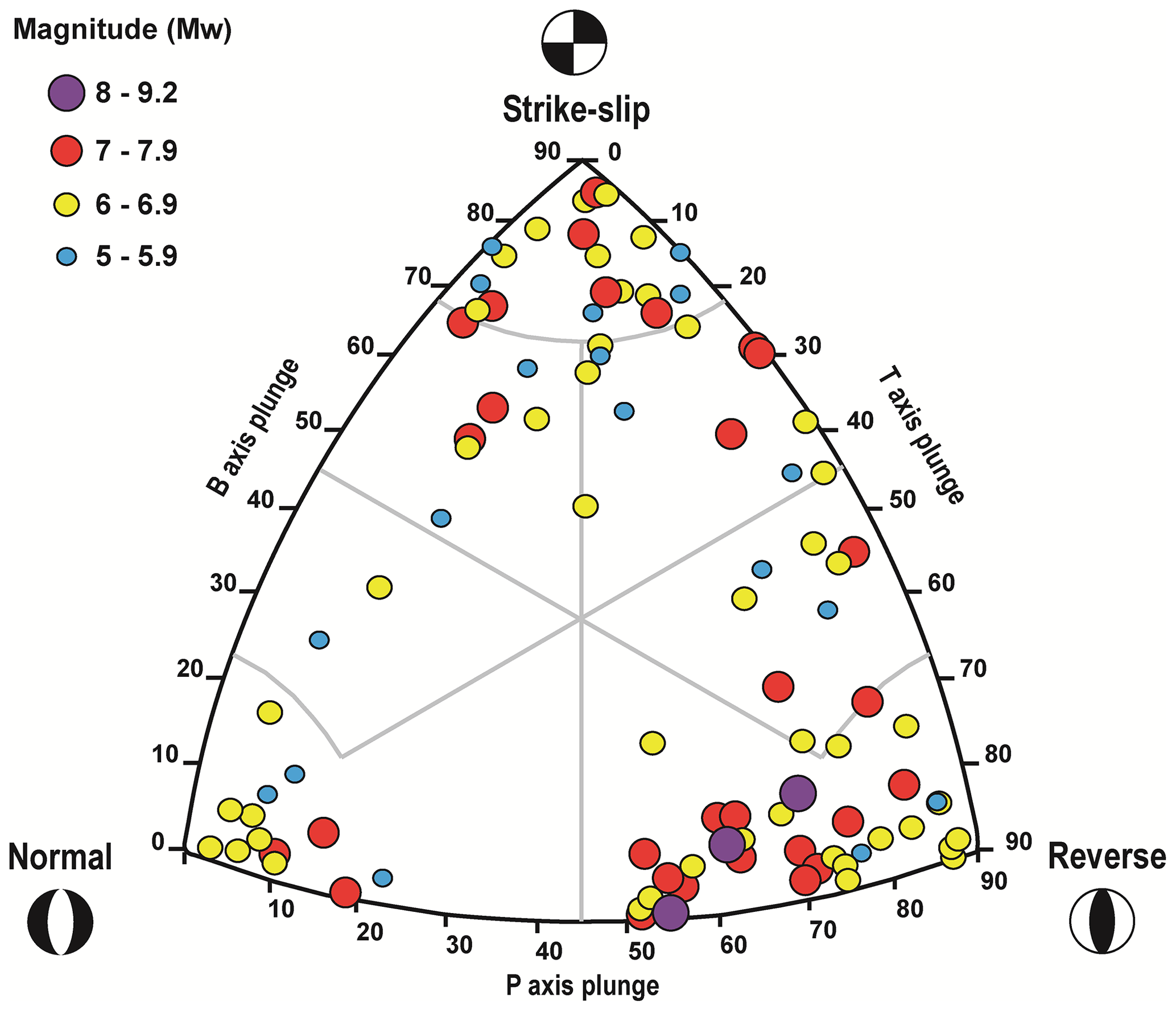
Figure 6Definition of the focal mechanism of 97 out of 136 investigated earthquakes according to the Kaverina-type DC classification diagram. Several earthquakes are not plotted due to the lack of information concerning P, T, and B centroid moment tensor axes.
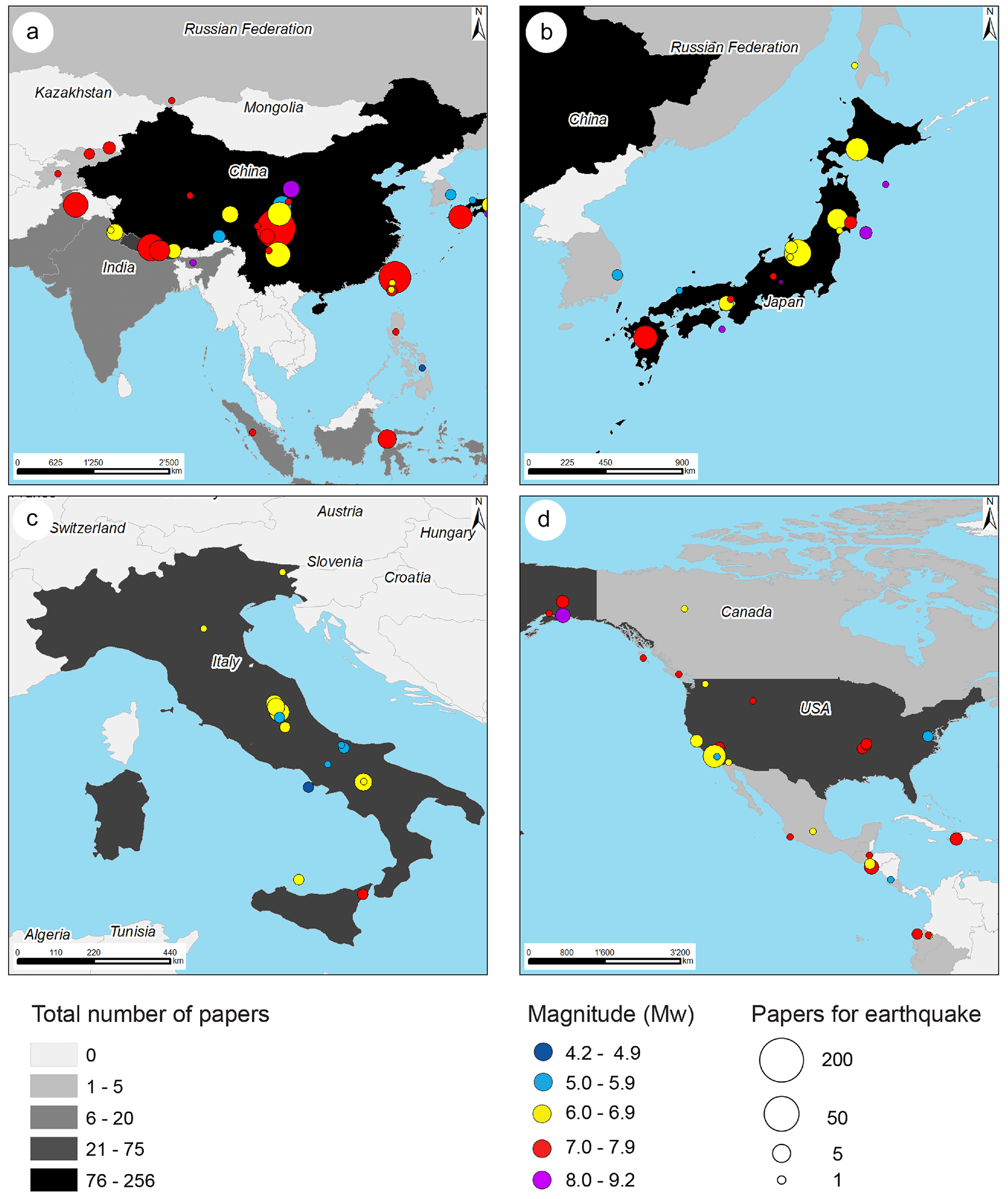
Figure 7Spatial distribution of the earthquakes listed in the database for four countries, i.e. China (a), Japan (b), Italy (c), and the USA (d). Colour indicates the magnitude, while the size of the circle is proportional to the number of articles dealing with the earthquake. Countries are classified based on the number of articles collected in the database.
Beyond the historical landslides, we also decided to include in the not applicable category all those articles dealing with landslides related to the geological hazard chain potentially resulting after an earthquake (Fan et al., 2019). In this respect, we identified three sub-categories:
-
water environment landslides (WEL) – this sub-category comprises 47 articles (29.7 %) specifically focused on the secondary effects of EQTLs in water environments, such as landslide-induced tsunamis (e.g. Takagi et al., 2019) and floods related to river landslide dams (e.g. Fan et al., 2012). In the case of historical earthquakes, EQTLs in water environments are generally used as evidence for confirming past tsunamis (e.g. Kitamura et al., 2020) and river damming events (e.g. Ehteshami-Moinabadi and Nasiri, 2019) or, more generally, the occurrence of one or multiple earthquakes in a specific area (e.g. Goto et al., 2010).
-
rainfall-induced landslides (RIL) – the nine articles (5.7 %) included in this sub-category were classified as not applicable, since an earthquake represents a predisposing factor for subsequent rainfall-induced failures, i.e. post-seismic landslides (Tanyas et al., 2021). In general, these papers deal with comprehensive landslide hazard assessments (e.g. Hong and Adler, 2007) or cascading effects' evaluations (e.g. Tunas et al., 2020).
-
landscape evolution (LE) – these eight articles (5.1 %) investigate the role of EQTLs as a surface process in the framework of landscape evolution, also considering other morphogenetic processes, for example, tectonic uplift (e.g. Gallousi and Koukouvelas, 2007; Li et al., 2019) or fluvial sediment discharge (e.g. Hovius et al., 1997; Marc et al., 2016).
Another sub-category of articles classified as not applicable includes works mainly focused on other earthquake-induced ground effects which can occur concurrently with EQTLs. In particular, 22 articles (13.9 % of the total) describe and discuss EQTLs together with co-seismic “ground deformation, and failure, and liquefaction processes” (GDFL) (e.g. He et al., 2020). However, it is important to stress that liquefaction is a relevant and important earthquake-induced ground effect which frequently occurs in flat areas and thus independently of EQTLs. Many scientific articles are specifically focused on this topic, but they are not listed in our database, since the word “liquefaction” is not one of the search keywords.
The analysis of “vegetation and EQTLs” (VAE) is addressed by 15 articles (9.5 %) and represents another sub-topic. These articles are focused on the stabilizing effect of vegetation recovery at landslide sites after earthquake events (Yang et al., 2018) or, conversely, on vegetation change/alteration induced by EQTLs (e.g. Cheng et al., 2012).
Finally, 21 articles were classified as fully not applicable (NA), since the topic addressed is not related to EQTLs, such as the dynamic response of slopes based on in situ monitoring systems (Moore et al., 2011; Lenti et al., 2015) or the evaluation of the hydrological response of landslide bodies under seismic loading (Beyabanaki et al., 2016; O'Brien et al., 2016).
3.2 Analysis of earthquake information
As mentioned in Sect. 2.1.3, the 810 articles collected in the database discuss and present ground effects of 136 earthquakes, mainly located in Italy, Japan, the USA, and China (Fig. 4). The earthquakes analysed in the articles agree with the typical distribution of the main seismicity at the global scale (Fig. 5), with most of the events located along the boundaries of the tectonic plates. About 80 % of the world's seismicity is situated along the circum-Pacific margin, corresponding to subduction zones, where earthquakes are caused by thrust-type and transcurrent-type faults (Toriumi, 2021). The focal mechanisms of the 136 earthquakes are predominantly associated with reverse and reverse–strike-slip faults (52 events, which correspond to 38.2 % of the total) and, secondly, to faults with a prevalent strike-slip component (45 events, which correspond to 33.1 % of the total) (Table 1 and Fig. 6). Moreover, the reverse-faulting mechanism characterizes not only most of the identified events but also the strongest (Mw≥8) ones, in agreement with the general observation that the largest earthquakes mainly occur in subduction zones (Funiciello et al., 2020).
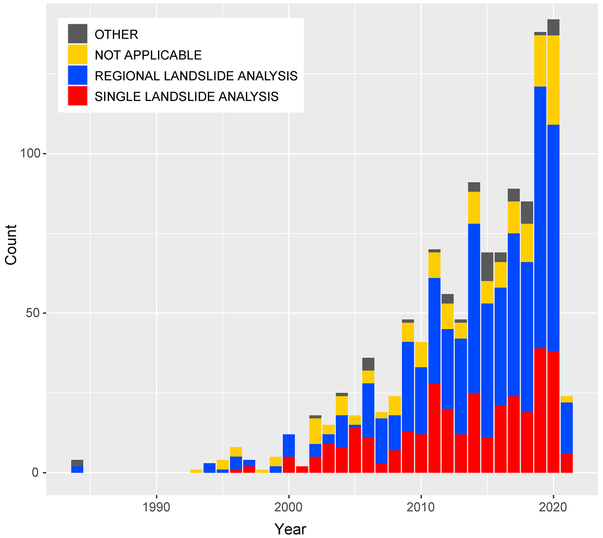
Figure 8The graph shows the temporal distribution of the main topics addressed by the authors in the 37-year period from April 1984 to February 2021.
As regards the intensity, 46 earthquakes (33.8 % of the total) have Mw≥7 (Table 2). Although it may seem like a large number, the data collected between 2000 and 2021 (https://www.usgs.gov/programs/earthquake-hazards/lists-maps-and-statistics, last access: 1 October 2022) indicate that the average yearly number of Mw≥7 earthquakes in the world is 15. This implies that strong earthquakes occurring worldwide are more numerous than those effectively analysed by the scientific community, at least in the framework of EQTLs. This can be explained considering that, in principle, the investigated earthquakes are those more impactful for human activities. In the specific case of EQTLs, scientific interest generally focuses on earthquakes occurring in populated areas or nearby. In this respect, most of the articles included in the database deal with earthquakes that occurred in the Asian inland and surrounding areas (Fig. 5). The devastating 2008 Wenchuan earthquake (Mw 7.9) is certainly the most studied event (180 articles), while the 1999 Chi-Chi earthquake (Mw 7.7) is the second-ranked one, although with a much lower number of articles (59) (Table 3). The most studied earthquake which did not occur on the Asian continent is the 1994 Northridge earthquake (Mw 6.7) with 13 articles. In general, earthquakes that occurred in China are the most studied events in the framework of EQTLs (i.e. 256 articles distributed among 13 earthquakes), followed by those located in Japan (i.e. 78 articles for 16 earthquakes) (Fig. 7a–b). It is interesting to note that the earthquakes that occurred in Italy, albeit more numerous (i.e. 19 events), are not as studied, since only 40 articles address these events, with a maximum value of 10 articles for the 2016 Amatrice earthquake (Mw 6.2) (Fig. 7c). This point can be explained considering that earthquakes tend to arouse scientific interest mainly at national level. In this sense, only 2 out of 40 articles do not include Italian authors. As regards the 16 earthquakes that occurred in the United States (Fig. 7d), only the 1994 Northridge earthquake has been examined in more than 5 articles (Table 3). Thus, if we consider that only 30 articles of the database focus on earthquakes in the USA, we can assert that these events, despite their high magnitudes (average Mw 7.1), have been analysed to a lesser extent, at least in relation to EQTLs.
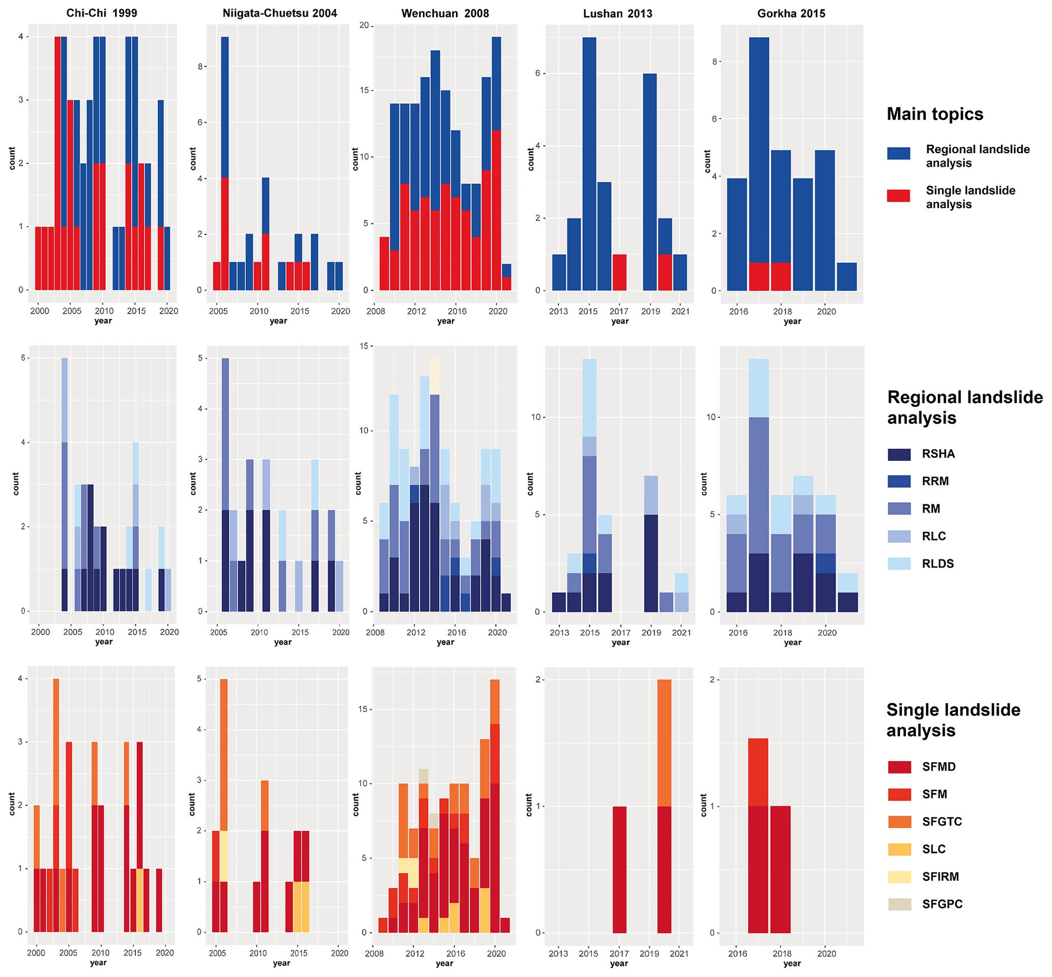
Figure 9Temporal analysis of the main topics (first row) and regional landslide (second row) and single-landslide (third row) sub-topics addressed by the articles dealing with the 1999 Chi-Chi (first column), 2004 Niigata–Chūetsu (second column), 2008 Wenchuan (third column), 2013 Lushan (fourth column), and 2015 Gorkha (fifth column) earthquakes.
Finally, it is interesting to highlight that 18 out of 136 earthquakes have been labelled as historical (i.e. before 1900). Only 20 articles focus on these events, with a maximum value of 4 papers for the 1786 Moxi earthquake (Table 4). Based on what is explained in Sect. 3.1.3, these articles have been classified as not applicable, since they concern historical landslides. Specifically, 6 articles can also be included in the sub-category “water environment landslides”, while only 1 article, which describes the effects of the 1811–1812 New Madrid earthquakes (Tuttle and Barstow, 1996), can be linked to the ground deformation, failure, and liquefaction processes sub-category.
3.3 Combined analysis of article topics and earthquake information
Based on the above information, we have performed combined analyses to evaluate the following: (i) the main topics and sub-topics addressed over time and (ii) the type of scientific evaluation performed for specific earthquake events. Figure 8 reveals that from the second half of the 2000s, the regional landslide analysis articles have always been more numerous than single-landslide analysis ones, with an almost constant proportion during the entire period. This confirms the increasing use, in the last few decades, of remote sensing data, especially satellite imageries, for the generation of EQTL inventories (Fan et al., 2019). This point, alongside the development of the calculation skills and performance of advanced computers, greatly enhanced and expedited the analysis of terrain data, especially over large areas.
As regards the analysis of specific earthquakes events, we selected the first five earthquakes listed in Table 3 (i.e. 1999 Chi-Chi, 2004 Niigata–Chūetsu, 2008 Wenchuan, 2013 Lushan, and 2015 Gorkha), for which more than 20 articles were published. The first three occurred more than 10 years ago and can be considered suitable for evaluating potential topic trends over the years.
In terms of the main topics, in the years immediately after the Chi-Chi earthquake, only single-landslide analysis articles were published (Fig. 9). On the contrary, in the first years after the Niigata–Chūetsu and Wenchuan earthquakes, regional landslide analysis studies were also performed. For the Wenchuan earthquake, the number of regional landslide analysis articles is even greater than that of single-landslide ones until 2014, i.e. 6 years after the event. The increasing trend of regional landslide analysis articles is further confirmed by the 2013 Lushan and 2015 Gorkha events. This result suggests that, in recent years, researchers have performed regional analyses as a priority with respect to slope-scale studies. Such a preference may be put in relation to the increasing availability of remote sensing data and high-performance computational tools, which enhance the execution of regional-scale analyses in a short time. On the contrary, the collection of data generally employed for slope-scale analyses can be extremely time-consuming, thus affecting the timing of publication. Within regional landslide articles we also noticed that, in general, “mapping” (RM) is the prevailing activity in the first period after the event, while “modelling” (RSHA) tends to increase over time. RM articles can also still be published several years after the event: these works can include updates of existing inventories (e.g. Chen et al., 2020) or ex novo mapping for in-depth analyses of landslide activity (e.g. Liu et al., 2020).
As regards single-landslide analysis articles, modelling (SFMD) is the prevailing activity and shows an increasing trend over the years (Fig. 9). Alongside modelling, geotechnical characterization (SFGTC), and mapping (SFMP) are generally carried out, especially in the first years after the Chi-Chi and Niigata–Chūetsu earthquakes, while other types of sub-topics are substantially secondary. In the case of Wenchuan, different SFMP articles have also been published in recent years (e.g. Cui et al., 2017). In this respect, although more than 60 000 landslides were triggered during the event (Gorum et al., 2011), only a few failures have been investigated individually. This leaves room for the verification of the real triggering and conditioning mechanisms, which as a matter of fact rely only on a few studies. Among these, the Daguangbao landslide is the most studied (e.g. Luo et al., 2020), probably due to its great size (7.5×10⁸ m3). As regards the Lushan and Gorkha events, very few articles have been published in the framework of the single-landslide analysis topic; thus, it was not possible to observe any specific trend.
In this work, we present a comprehensive database of the main scientific articles published in the last 4 decades on the EQTL theme. After the identification of 810 papers, the database was compiled in a GIS environment, specifying, for each article, different types of information. Great effort was dedicated to the identification of the earthquakes addressed and to the articles' grouping with respect to the main topics and sub-topics relevant to EQTLs. In this sense, we highlighted that more than 50 % of the articles focus on regional analyses which, in turn, are equally distributed among modelling and mapping sub-topics. On the contrary, single-landslide analysis works, which represent just over a quarter of the total number of articles, deal more with modelling-type activities and, secondarily, with geotechnical characterization of the landslide body. As regards the earthquakes addressed, although a great part of the 136 identified events occurred in four different countries (Italy, Japan, the United States, and China), earthquakes which took place in China are by far the most studied events (256 articles), although 180 out of these 256 articles analyse the 2008 Wenchuan earthquake. Finally, by analysing the topics addressed over time for the five main earthquakes (1999 Chi-Chi, 2004 Niigata–Chūetsu, 2008 Wenchuan, 2013 Lushan, and 2015 Gorkha), we pointed out an increasing trend of regional landslide analysis articles in the last few years, alongside a growing use of modelling approaches for both regional-landslide-scale and single-landslide-scale analyses. However, it is important to stress that the considerations presented in this work just represent general inferences resulting from the analysis of the collected articles. More specific observations would require an in-depth, critical analysis of the articles, which is beyond the scope of the present study. In fact, this work can be considered a starting point for further analysis and investigations and is proposed to experts and the general reader interested in a broader view of EQTLs.
As regards future activities, it is important to note that the database can be updated very promptly. In this respect, authors invite all readers to report not only newly published articles on EQTL themes but also articles that have been published in the past and were not included in the database due to shortcomings in the use of keywords during the literature search on the Web of Science database. Future versions of the database can also be improved through integration with other sources of information, such as the ISC Event Bibliography. In conclusion, the web-GIS database presented here can represent a powerful tool for performing cross-correlated literature searches focused on specific main topics and sub-topics in relation to given earthquake events and/or study areas.
The web-GIS described in the article can be accessed at http://194.119.218.119/it/map/a-web-gis-database-of-the-scientific-articles-on-e/qdjango/54/ (last access: 1 January 2023; g3w, 2023). It was implemented using G3W-SUITE, an open-source application for the publication and management of QGIS cartographic projects. G3W-SUITE can be downloaded at https://g3wsuite.it/en/download-g3w-suite/ (last access: 1 January 2023; g3wSuite, 2023), while QGIS, which is an open-source GIS application for the analysis of geospatial data, can be downloaded at https://qgis.org/en/site/ (last access: 1 January 2023; QGIS, 2023). For the definition of the focal mechanisms reported in Fig. 6, we used FMC (version 1.3), open-source software which can be downloaded at https://github.com/ElsevierSoftwareX/SOFTX_2018_227 (last access: 1 January 2023; ElsevierSoftwareX, 2023).
Data described in the article have been collected in a specific database, which is available in the Supplement as an .xlsx file.
The supplement related to this article is available online at: https://doi.org/10.5194/nhess-23-1789-2023-supplement.
LS: conceptualization, data curation, writing – original draft; MR: conceptualization, data curation, software, writing – review and editing; FP: data curation, writing – review and editing; FF: web-GIS conceptualization and set-up, data curation, writing – review and editing; CF: data curation, writing – review and editing; PR: conceptualization, data curation, writing – review and editing, supervision, project administration.
At least one of the (co-)authors is a member of the editorial board of Natural Hazards and Earth System Sciences. The peer-review process was guided by an independent editor, and the authors also have no other competing interests to declare.
Publisher’s note: Copernicus Publications remains neutral with regard to jurisdictional claims in published maps and institutional affiliations.
This article is part of the special issue “Earthquake-induced hazards: ground motion amplification and ground failures”. It is a result of the EGU General Assembly 2022, 23–27 May 2022.
This research has been supported by the Italian Ministry of Ecological Transition (Ministero della Transizione Ecologica) under the project FRA.SI – multi-scale integrated methodologies for seismically induced landslides hazard zonation in Italy (Metodologie integrate multi-scala per la zonazione della pericolosità da frana sismo-indotta in Italia) (grant no. bando DD 449/2018)
This paper was edited by Giovanni Forte and reviewed by Ioannis Koukouvelas and one anonymous referee.
Allstadt, K. E., Thompson, E. M., Jibson, R. W., Wald, D. J., Hearne, M., Hunter, E. J., Fee, J., Schovanec, H., Slosky, D., and Haynie, K. L.: The US Geological Survey ground failure product: Near-real-time estimates of earthquake-triggered landslides and liquefaction, Earthq. Spectra, 38, 5–36, https://doi.org/10.1177/87552930211032685, 2022.
Álvarez-Gómez, J. A.: FMC – Earthquake focal mechanisms data management, cluster and classification, SoftwareX, 9, 299–307, https://doi.org/10.1016/j.softx.2019.03.008, 2019.
Aydan, Ö.: Large Rock Slope Failures Induced by Recent Earthquakes, Rock Mech. Rock Eng., 49, 2503–2524, https://doi.org/10.1007/s00603-016-0975-3, 2016.
Beyabanaki, S. A. R., Bagtzoglou, A. C., and Anagnostou, E. N.: Effects of groundwater table position, soil strength properties and rainfall on instability of earthquake-triggered landslides, Environ. Earth Sci., 75, 358, https://doi.org/10.1007/s12665-016-5277-2, 2016.
Bird, J. F. and Bommer, J. J.: Earthquake losses due to ground failure, Eng. Geol., 75, 147–179, https://doi.org/10.1016/j.enggeo.2004.05.006, 2004.
Bozzano, F., Lenti, L., Martino, S., Paciello, A., and Scarascia Mugnozza, G.: Self-excitation process due to local seismic amplification responsible for the reactivation of the Salcito landslide (Italy) on 31 October 2002, J. Geophys. Res., 113, B10312, https://doi.org/10.1029/2007JB005309, 2008.
Chen, M., Tang, C., Xiong, J., Shi, Q. Y., Li, N., Gong, L. F., Wang, X. D., and Tie, Y.: The long-term evolution of landslide activity near the epicentral area of the 2008 Wenchuan earthquake in China, Geomorphology, 367, 107317, https://doi.org/10.1016/j.geomorph.2020.107317, 2020.
Cheng, S., Yang, G., Yu, H., Li, J., and Zhang, L.: Impacts of Wenchuan Earthquake-induced landslides on soil physical properties and tree growth, Ecol. Indic., 15, 263–270, https://doi.org/10.1016/j.ecolind.2011.09.028, 2012.
Cui, P., Dang, C., Zhuang, J., You, Y., Chen, X., and Scott, K. M.: Landslide-dammed lake at Tangjiashan, Sichuan province, China (triggered by the Wenchuan Earthquake, May 12, 2008): risk assessment, mitigation strategy, and lessons learned, Environ. Earth Sci., 65, 1055–1065, https://doi.org/10.1007/s12665-010-0749-2, 2012.
Cui, S., Wang, G., Pei, X., Huang, R., and Kamai, T.: On the initiation and movement mechanisms of a catastrophic landslide triggered by the 2008 Wenchuan (Ms 8.0) earthquake in the epicenter area, Landslides, 14, 805–819, https://doi.org/10.1007/s10346-016-0754-y, 2017.
Dang, K., Sassa, K., Fukuoka, H., Sakai, N., Sato, Y., Takara, K., Quang, L. H., Loi, D. H., Van Tien, P., and Ha, N. D.: Mechanism of two rapid and long-runout landslides in the 16 April 2016 Kumamoto earthquake using a ring-shear apparatus and computer simulation (LS-RAPID), Landslides, 13, 1525–1534, https://doi.org/10.1007/s10346-016-0748-9, 2016.
Di Giacomo, D., Storchak, D. A., Safronova, N., Ozgo, P., Harris, J., Verney, R., and Bondár, I.: A New ISC Service: the Bibliography of Seismic Events, Seismol. Res. Lett., 85, 354–360, https://doi.org/10.1785/0220130143, 2014
Ehteshami-Moinabadi, M. and Nasiri, S.: Geometrical and structural setting of landslide dams of the Central Alborz: a link between earthquakes and landslide damming, Bull. Eng. Geol. Environ., 78, 69–88, https://doi.org/10.1007/s10064-017-1021-8, 2019.
ElsevierSoftwareX: SOFTX_2018_227, GitHub [code], https://github.com/ElsevierSoftwareX/SOFTX_2018_227, last access: 1 January 2023.
Fan, X., Tang, C. X., van Westen, C. J., and Alkema, D.: Simulating dam-breach flood scenarios of the Tangjiashan landslide dam induced by the Wenchuan Earthquake, Nat. Hazards Earth Syst. Sci., 12, 3031–3044, https://doi.org/10.5194/nhess-12-3031-2012, 2012.
Fan, X., Scaringi, G., Korup, O., West, A. J., Westen, C. J., Tanyas, H., Hovius, N., Hales, T. C., Jibson, R. W., Allstadt, K. E., Zhang, L., Evans, S. G., Xu, C., Li, G., Pei, X., Xu, Q., and Huang, R.: Earthquake-Induced Chains of Geologic Hazards: Patterns, Mechanisms, and Impacts, Rev. Geophys., 57, 421–503, https://doi.org/10.1029/2018RG000626, 2019.
Fortunato, C., Martino, S., Prestininzi, A., and Romeo, R. W.: Nuova versione del catalogo italiano degli effetti deformativi indotti da forti terremoti (CEDIT), Ital. J. Eng. Geol. Environ., 2, 63–74, https://doi.org/10.4408/IJEGE.2012-02.O-05, 2012.
Funiciello, F., Corbi, F., Heuret, A., Piromallo, C., and Rosenau, M.: Empirical Analysis of Global-Scale Natural Data and Analogue Seismotectonic Modelling Data to Unravel the Seismic Behaviour of the Subduction Megathrust, Front. Earth Sci., 8, 600152, https://doi.org/10.3389/feart.2020.600152, 2020.
g3w: A web-GIS database of the scientific articles on earthquake-triggered landslides, g3w [data set], http://194.119.218.119/it/map/a-web-gis-database-of-the-scientific-articles-on-e/qdjango/54/, last access: 1 January 2023.
g3wSuite: G3W-Suite is Open Source, g3wSuite [code], https://g3wsuite.it/en/download-g3w-suite/, last access: 1 January 2023.
Gallousi, C. and Koukouvelas, I. K.: Quantifying geomorphic evolution of earthquake-triggered landslides and their relation to active normal faults. An example from the Gulf of Corinth, Greece, Tectonophysics, 440, 85–104, https://doi.org/10.1016/j.tecto.2007.02.009, 2007.
Gorum, T., Fan, X., van Westen, C. J., Huang, R. Q., Xu, Q., Tang, C., and Wang, G.: Distribution pattern of earthquake-induced landslides triggered by the 12 May 2008 Wenchuan earthquake, Geomorphology, 133, 152–167, https://doi.org/10.1016/j.geomorph.2010.12.030, 2011.
Goto, A. S., Muramatsu, T., and Teraoka, Y.: Timing of the Landslide-Dammed Lake Triggered by Earthquake, at Toyama River, Central Japan, Radiocarbon, 52, 1090–1097, https://doi.org/10.1017/S0033822200046178, 2010.
Gratchev, I. and Towhata, I.: Geotechnical characteristics of volcanic soil from seismically induced Aratozawa landslide, Japan, Landslides, 7, 503–510, https://doi.org/10.1007/s10346-010-0211-2, 2010.
Guerrieri, L., Michetti, A. M., and Silva, P. G.: EEE Catalogue: A Global Database of Earthquake Environmental Effects, in: Encyclopedia of Earthquake Engineering, edited by: Beer, M., Kougioumtzoglou, I. A., Patelli, E., and Au, SK., Springer, Berlin, Heidelberg, https://doi.org/10.1007/978-3-642-35344-4_32, 2015.
Guo, D., Hamada, M., He, C., Wang, Y., and Zou, Y.: An empirical model for landslide travel distance prediction in Wenchuan earthquake area, Landslides, 11, 281–291, https://doi.org/10.1007/s10346-013-0444-y, 2014.
Havenith, H.-B., Jongmans, D., Faccioli, E., Abdrakhmatov, K., and Bard, P.-Y.: Site Effect Analysis around the Seismically Induced Ananevo Rockslide, Kyrgyzstan, Bull. Seismol. Soc. Am., 92, 3190–3209, https://doi.org/10.1785/0120010206, 2002.
He, J., Qi, S., Wang, Y., and Saroglou, C.: Seismic response of the Lengzhuguan slope caused by topographic and geological effects, Eng. Geol., 265, 105431, https://doi.org/10.1016/j.enggeo.2019.105431, 2020.
Hong, Y. and Adler, R. F.: Towards an early-warning system for global landslides triggered by rainfall and earthquake, Int. J. Remote Sens., 28, 3713–3719, https://doi.org/10.1080/01431160701311242, 2007.
Hovius, N., Stark, C. P., and Allen, P. A.: Sediment flux from a mountain belt derived by landslide mapping, Geology, 25, 231–234, https://doi.org/10.1130/0091-7613(1997)025<0231:SFFAMB>2.3.CO;2, 1997.
Hu, K., Zhang, X., You, Y., Hu, X., Liu, W., and Li, Y.: Landslides and dammed lakes triggered by the 2017 Ms6.9 Milin earthquake in the Tsangpo gorge, Landslides, 16, 993–1001, https://doi.org/10.1007/s10346-019-01168-w, 2019.
Huang, D., Song, Y. X., Ma, G. W., Pei, X. J., and Huang, R. Q.: Numerical modeling of the 2008 Wenchuan earthquake-triggered Niumiangou landslide considering effects of pore-water pressure, Bull. Eng. Geol. Environ., 78, 4713–4729, https://doi.org/10.1007/s10064-018-01433-7, 2019.
Islam, N., Hawlader, B., Wang, C., and Soga, K.: Large-deformation finite-element modelling of earthquake-induced landslides considering strain-softening behaviour of sensitive clay, Can. Geotech. J., 56, 1003–1018, https://doi.org/10.1139/cgj-2018-0250, 2019.
Jibson, R. W.: Methods for assessing the stability of slopes during earthquakes – a retrospective, Eng. Geol., 122, 43–50, https://doi.org/10.1016/j.enggeo.2010.09.017, 2011.
Jibson, R. W. and Harp, E. L.: Extraordinary Distance Limits of Landslides Triggered by the 2011 Mineral, Virginia, Earthquake, Bull. Seismol. Soc. Am., 102, 2368–2377, https://doi.org/10.1785/0120120055, 2012.
Jibson, R. W. and Tanyaş, H.: The influence of frequency and duration of seismic ground motion on the size of triggered landslides – A regional view, Eng. Geol., 273, 105671, https://doi.org/10.1016/j.enggeo.2020.105671, 2020.
Jibson, R. W., R. Grant, A. R., Witter, R. C., Allstadt, K. E., Thompson, E. M., and Bender, A. M.: Ground Failure from the Anchorage, Alaska, Earthquake of 30 November 2018, Seismol. Res. Lett., 91, 19–32, https://doi.org/10.1785/0220190187, 2020.
Jin, K. P., Yao, L. K., Cheng, Q. G., and Xing, A. G.: Seismic landslides hazard zoning based on the modified Newmark model: a case study from the Lushan earthquake, China, Nat. Hazards, 99, 493–509, https://doi.org/10.1007/s11069-019-03754-6, 2019.
Kaverina, A. N., Lander, A. V., and Prozorov, A. G.: Global Creepex Distribution and Its Relation to Earthquake-Source Geometry and Tectonic Origin, Geophys. J. Int., 125, 249–265, https://doi.org/10.1111/j.1365-246X.1996.tb06549.x, 1996.
Keefer, D. K.: Landslides caused by earthquakes, Geol. Soc. Am. Bull., 95, 406–421, 1984
Keefer, D. K.: Earthquake-induced landslides and their effects on alluvial fans, J. Sediment. Res., 69, 84–104, https://doi.org/10.2110/jsr.69.84, 1999.
Keefer, D. K.: Investigating landslides caused by earthquakes – A historical review, Surv. Geophys., 23, 473–510, https://doi.org/10.1023/A:1021274710840, 2002.
Kitamura, A., Yamada, K., Sugawara, D., Yokoyama, Y., Miyairi, Y., Hirakawa, M., Iwatsuki, D., Katagiri, S., Maeda, M., Mori, H., Nakai, Y., Okazaki, S., Sakamoto, Y., Sasada, M., Seki, Y., Takikawa, Y., Yamamoto, Y., and Yoda, Y.: Tsunamis and submarine landslides in Suruga Bay, central Japan, caused by Nankai–Suruga Trough megathrust earthquakes during the last 5000 years, Quaternary Sci. Rev., 245, 106527, https://doi.org/10.1016/j.quascirev.2020.106527, 2020.
Kojima, S., Nozaki, T., Nagata, H., Tanahashi, R., Kondo, R., Okamura, N., Suzuki, K., Ikeda, A., Nakamura, T., and Ohtani, T.: Large-scale landslides in Toyama Prefecture, central Japan, and their probable relationship with earthquakes, Environ. Earth Sci., 71, 2753–2763, https://doi.org/10.1007/s12665-013-2654-y, 2014.
Koukouvelas, I. K., Piper, D. J., Katsonopoulou, D., Kontopoulos, N., Verroios, S., Nikolakopoulos, K., and Zygouri, V.: Earthquake-triggered landslides and mudflows: Was this the wave that engulfed Ancient Helike?, The Holocene, 30, 1653–1668, https://doi.org/10.1177/0959683620950389, 2020.
Lenti, L., Martino, S., Paciello, A., Prestininzi, A., and Rivellino, S.: Recorded displacements in a landslide slope due to regional and teleseismic earthquakes, Geophys. J. Int., 201, 1335–1345, https://doi.org/10.1093/gji/ggv063, 2015.
Li, B., Xing, A., and Xu, C.: Simulation of a long-runout rock avalanche triggered by the Lushan earthquake in the Tangjia Valley, Tianquan, Sichuan, China, Eng. Geol., 218, 107–116, https://doi.org/10.1016/j.enggeo.2017.01.007, 2017.
Li, G., West, A. J., and Qiu, H.: Competing Effects of Mountain Uplift and Landslide Erosion Over Earthquake Cycles, J. Geophys. Res.-Sol. Ea., 124, 5101–5133, https://doi.org/10.1029/2018JB016986, 2019.
Liu, B., Hu, X., He, K., He, S., Shi, H., and Liu, D.: The starting mechanism and movement process of the coseismic rockslide: A case study of the Laoyingyan rockslide induced by the “5.12” Wenchuan earthquake, J. Mt. Sci., 17, 1188–1205, https://doi.org/10.1007/s11629-019-5775-2, 2020.
Luo, X., Wang, C., Long, Y., and Yi, Z.: Analysis of the Decadal Kinematic Characteristics of the Daguangbao Landslide Using Multiplatform Time Series InSAR Observations After the Wenchuan Earthquake, J. Geophys. Res.-Sol. Ea., 125, e2019JB019325, https://doi.org/10.1029/2019JB019325, 2020.
Lv, Y., Peng, J., and Wang, G.: Characteristics and genetic mechanism of the Cuihua Rock Avalanche triggered by a paleo-earthquake in northwest China, Eng. Geol., 182, 88–96, https://doi.org/10.1016/j.enggeo.2014.08.017, 2014.
Marano, K. D., Wald, D. J., and Allen, T. I.: Global earthquake casualties due to secondary effects: a quantitative analysis for improving rapid loss analyses, Nat. Hazards, 52, 319–328, https://doi.org/10.1007/s11069-009-9372-5, 2010.
Marc, O., Hovius, N., and Meunier, P.: The mass balance of earthquakes and earthquake sequences, Geophys. Res. Lett., 43, 3708–3716, https://doi.org/10.1002/2016GL068333, 2016.
Marc, O., Meunier, P., and Hovius, N.: Prediction of the area affected by earthquake-induced landsliding based on seismological parameters, Nat. Hazards Earth Syst. Sci., 17, 1159–1175, https://doi.org/10.5194/nhess-17-1159-2017, 2017.
Martino, S., Bozzano, F., Caporossi, P., D'angiò, D., Della Seta, M., Esposito, C., Fantini, A., Fiorucci, M., Giannini, L.M., Iannucci, R., Marmoni, G.M., Mazzanti, P., Missori, C., Moretto, S., Rivellino, S., Romeo, R.W., Sarandrea, P., Schilirò L., Troiani F., and Varone C.: Ground effects triggered by the 24th August 2016, Mw 6.0 Amatrice (Italy) earthquake: surveys and inventorying to update the CEDIT catalogue, Geogr. Fis. Din. Quat., 77–95, https://doi.org/10.4461/GFDQ.2017.40.7, 2017.
Martino, S., Battaglia, S., D'Alessandro, F., Della Seta, M., Esposito, C., Martini, G., Pallone, F., and Troiani, F.: Earthquake-induced landslide scenarios for seismic microzonation: application to the Accumoli area (Rieti, Italy), Bull. Earthquake Eng., 18, 5655–5673, https://doi.org/10.1007/s10518-019-00589-1, 2020.
Masi, A., Chiauzzi, L., Nicodemo, G., and Manfredi, V.: Correlations between macroseismic intensity estimations and ground motion measures of seismic events, Bull. Earthquake Eng., 18, 1899–1932, https://doi.org/10.1007/s10518-019-00782-2, 2020.
Michetti, A. M., Esposito, E., Guerrieri, L., Porfido, S., Serva, L., Tatevossian, R., Vittori, E., Audemard, F., Azuma, T., Clague, J., Comerci, V., Gürpinar, A., Mc Calpin, J., Mohammadioun, B., Mörner, N. A., Ota, Y., and Roghozin, E.: Intensity Scale ESI 2007, in: Memorie Descrittive Carta Geologica d'Italia, edited by: Guerrieri, L. and Vittori, E., Servizio Geologico d'Italia, Dipartimento Difesa del Suolo, APAT, Rome, Italy, 74, ISBN 978-88-240-2903-2, ISSN 0536-0242, 2007.
Moore, J. R., Gischig, V., Burjanek, J., Loew, S., and Fah, D.: Site Effects in Unstable Rock Slopes: Dynamic Behavior of the Randa Instability (Switzerland), Bull. Seismol. Soc. Am., 101, 3110–3116, https://doi.org/10.1785/0120110127, 2011.
Mousavi, S. M., Omidvar, B., Ghazban, F., and Feyzi, R.: Quantitative risk analysis for earthquake-induced landslides – Emamzadeh Ali, Iran, Eng. Geol., 122, 191–203, https://doi.org/10.1016/j.enggeo.2011.05.010, 2011.
Nakamura, S., Wakai, A., Umemura, J., Sugimoto, H., and Takeshi, T.: Earthquake-induced landslides: Distribution, motion and mechanisms, Soils Found., 54, 544–559, https://doi.org/10.1016/j.sandf.2014.06.001, 2014.
Newmark, N. M.: Effects of Earthquakes on Dams and Embankments, Géotechnique, 15, 139–160, https://doi.org/10.1680/geot.1965.15.2.139, 1965.
Nian, T., Zhang, Y., Wu, H., Chen, G., and Zheng, L.: Runout simulation of seismic landslides using discontinuous deformation analysis (DDA) with state-dependent shear strength model, Can. Geotech. J., 57, 1183–1196, https://doi.org/10.1139/cgj-2019-0312, 2020.
O'Brien, G. A., Cox, S. C., and Townend, J.: Spatially and temporally systematic hydrologic changes within large geoengineered landslides, Cromwell Gorge, New Zealand, induced by multiple regional earthquakes, J. Geophys. Res.-Sol Ea., 121, 8750–8773, https://doi.org/10.1002/2016JB013418, 2016.
Pérez-Lopez, R., Giner-Robles, J. L., Rodríguez-Pascua, M. A., Silva, P. G., Roquero, E., Bardají, T., Elez, J., and Huerta, P.: Lichenometric dating of coseismic rockfall related to the Great Lisbon Earthquake in 1755 affecting the archaeological site of “Tolmo de Minateda” (Spain), Zeit. fur Geo. Supp., 62, 271–293, https://doi.org/10.1127/zfg_suppl/2019/0504, 2019
Polykretis, C., Kalogeropoulos, K., Andreopoulos, P., Faka, A., Tsatsaris, A., and Chalkias, C.: Comparison of Statistical Analysis Models for Susceptibility Assessment of Earthquake-Triggered Landslides: A Case Study from 2015 Earthquake in Lefkada Island, Geosciences, 9, 350, https://doi.org/10.3390/geosciences9080350, 2019.
Pu, X., Wang, L., Wang, P., and Chai, S.: Study of shaking table test of seismic subsidence loess landslides induced by the coupling effect of earthquakes and rainfall, Nat. Hazards, 103, 923–945, https://doi.org/10.1007/s11069-020-04019-3, 2020.
QGIS: A Free and Open Source Geographic Information System, QGIS [code], https://qgis.org/en/site/, last access: 1 January 2023.
Razifard, M., Shoaei, G., and Zare, M.: Application of fuzzy logic in the preparation of hazard maps of landslides triggered by the twin Ahar-Varzeghan earthquakes (2012), Bull. Eng. Geol. Environ., 78, 223–245, https://doi.org/10.1007/s10064-018-1235-4, 2019.
Reichenbach, P., Rossi, M., Malamud, B. D., Mihir, M., and Guzzetti, F.: A review of statistically-based landslide susceptibility models, Earth-Sci. Rev., 180, 60–91, https://doi.org/10.1016/j.earscirev.2018.03.001, 2018.
Roback, K., Clark, M. K., West, A. J., Zekkos, D., Li, G., Gallen, S. F., Chamlagain, D., and Godt, J. W.: The size, distribution, and mobility of landslides caused by the 2015 Mw7.8 Gorkha earthquake, Nepal, Geomorphology, 301, 121–138, https://doi.org/10.1016/j.geomorph.2017.01.030, 2018.
Rodríguez-Peces, M. J., García-Mayordomo, J., Azañón, J. M., Insua Arévalo, J. M., and Pintor, J. J.: Constraining pre-instrumental earthquake parameters from slope stability back-analysis: Palaeoseismic reconstruction of the Güevéjar landslide during the 1st November 1755 Lisbon and 25th December 1884 Arenas del Rey earthquakes, Quatern. Int., 242, 76–89, https://doi.org/10.1016/j.quaint.2010.11.027, 2011.
Rodríguez-Peces, M. J., Román-Herrera, J. C., Peláez, J. A., Delgado, J., Tsige, M., Martino, S., and Garrido, J.: Unbiased logic-tree data for earthquake-induced landslide hazard maps for low-to-moderate magnitude events, Data in Brief, 31, 105940, https://doi.org/10.1016/j.dib.2020.105940, 2020.
Romeo, R.: Seismically induced landslide displacements: a predictive model, Eng. Geol., 58, 337–351, https://doi.org/10.1016/S0013-7952(00)00042-9, 2000.
Saito, H., Uchiyama, S., Hayakawa, Y. S., and Obanawa, H.: Landslides triggered by an earthquake and heavy rainfalls at Aso volcano, Japan, detected by UAS and SfM-MVS photogrammetry, Prog. Earth Planet. Sci., 5, 15, https://doi.org/10.1186/s40645-018-0169-6, 2018.
Struble, W. T., Roering, J. J., Black, B. A., Burns, W. J., Calhoun, N., and Wetherell, L.: Dendrochronological dating of landslides in western Oregon: Searching for signals of the Cascadia A.D. 1700 earthquake, Geol. Soc. Am. Bull., 132, 1775–1791, https://doi.org/10.1130/B35269.1, 2020.
Takagi, H., Pratama, M. B., Kurobe, S., Esteban, M., Aránguiz, R., and Ke, B.: Analysis of generation and arrival time of landslide tsunami to Palu City due to the 2018 Sulawesi earthquake, Landslides, 16, 983–991, https://doi.org/10.1007/s10346-019-01166-y, 2019.
Tanyaş, H. and Lombardo, L.: Completeness Index for Earthquake-Induced Landslide Inventories, Eng. Geol., 264, 105331, https://doi.org/10.1016/j.enggeo.2019.105331, 2020.
Tanyaş, H., van Westen, C. J., Allstadt, K. E., Anna Nowicki Jessee, M., Görüm, T., Jibson, R. W., Godt, J.W., Sato, H.P., Schmitt, R.J., Marc, O., and Hovius, N.: Presentation and analysis of a worldwide database of earthquake-induced landslide inventories, J. Geophys. Res.-Earth, 122, 1991–2015, https://doi.org/10.1002/2017JF004236, 2017.
Tanyas, H., Kirschbaum, D., Görüm, T., van Westen, C. J, and Lombardo, L.: New Insight into Post-seismic Landslide Evolution Processes in the Tropics, Front. Earth Sci., 9, 700546, https://doi.org/10.3389/feart.2021.700546, 2021.
Tian, Y., Xu, C., Hong, H., Zhou, Q., and Wang, D.: Mapping earthquake-triggered landslide susceptibility by use of artificial neural network (ANN) models: an example of the 2013 Minxian (China) Mw 5.9 event, Geomat. Nat. Haz. Risk, 10, 1–25, https://doi.org/10.1080/19475705.2018.1487471, 2019.
Toriumi, M.: Global Seismicity Dynamics and Data-Driven Science: Seismicity Modelling by Big Data Analytics, Springer Singapore, Singapore, 231, https://doi.org/10.1007/978-981-15-5109-3, 2021.
Tunas, I. G., Tanga, A., and Oktavia, S.: Impact of Landslides Induced by the 2018 Palu Earthquake on Flash Flood in Bangga River Basin, Sulawesi, Indonesia, J. Ecol. Eng., 21, 190–200, https://doi.org/10.12911/22998993/116325, 2020.
Tuttle, M. and Barstow, N.: Liquefaction-related ground failure: A case study in the New Madrid seismic zone, central United States, Bull. Seismol. Soc. Am., 86, 636–645, 1996.
Vega, J. A. and Hidalgo, C. A.: Quantitative risk assessment of landslides triggered by earthquakes and rainfall based on direct costs of urban buildings, Geomorphology, 273, 217–235, https://doi.org/10.1016/j.geomorph.2016.07.032, 2016.
Villani, F., Civico, R., Pucci, S., Pizzimenti, L., Nappi, R., and De Martini, P. M.: Open EMERGEO working group, 2018. A database of the coseismic effects following the 30 October 2016 Norcia earthquake in Central Italy. Scientific Data 5, 180049, https://doi.org/10.1038/sdata.2018.49, 2018.
Wasowski, J., Keefer, D. K., and Lee, C.-T.: Toward the next generation of research on earthquake-induced landslides: Current issues and future challenges, Eng. Geol., 122, 1–8, https://doi.org/10.1016/j.enggeo.2011.06.001, 2011.
Web of Science Group: 2021, Web of Science-Core Collection, https://clarivate.com/webofsciencegroup/solutions/web-of-science-core-collection/, last access: 27 September 2021.
Yang, W., Qi, W., and Zhou, J.: Decreased post-seismic landslides linked to vegetation recovery after the 2008 Wenchuan earthquake, Ecol. Indic., 89, 438–444, https://doi.org/10.1016/j.ecolind.2017.12.006, 2018.
Zhang, Z., Fleurisson, J.-A., and Pellet, F. L.: Numerical evidence of site effects contributing to triggering the Las Colinas landslide during the 2001 Mw = 7.7 El Salvador earthquake, Landslides, 15, 2373–2384, https://doi.org/10.1007/s10346-018-1040-y, 2018.
Zhao, T. and Crosta, G. B.: On the Dynamic Fragmentation and Lubrication of Coseismic Landslides, J. Geophys. Res.-Sol. Earth, 123, 9914–9932, https://doi.org/10.1029/2018JB016378, 2018.
- Abstract
- Introduction
- Data and structure of the literature database
- Preliminary analysis of the literature database
- Final remarks and conclusions
- Code availability
- Data availability
- Author contributions
- Competing interests
- Disclaimer
- Special issue statement
- Financial support
- Review statement
- References
- Supplement