the Creative Commons Attribution 4.0 License.
the Creative Commons Attribution 4.0 License.
 | 14 Jan 2021
Beachgoers' ability to identify rip currents at a beach in situ
Sebastian J. Pitman
Katie Thompson
Deirdre E. Hart
Kevin Moran
Shari L. Gallop
Robert W. Brander
Adam Wooler
Rip currents (“rips”) are the leading cause of drowning on surf beaches worldwide. A major contributing factor is that many beachgoers are unable to identify rip currents. Previous research has attempted to quantify beachgoers' rip identification ability using photographs of rip currents without identifying whether this usefully translates into an ability to identify a rip current in situ at the beach. This study is the first to compare beachgoers ability to identify rip currents in photographs and in situ at a beach in New Zealand (Muriwai Beach) where a channel rip current was present. Only 22 % of respondents were able to identify the in situ rip current. The highest rates of success were for males (33 %), New Zealand residents (25 %), and local beach users (29 %). Of all respondents who were successful at identifying the rip current in situ, 62 % were active surfers/bodyboarders, and 28 % were active beach swimmers. Of the respondents who were able to identify a rip current in two photographs, only 34 % were able to translate this into a successful in situ rip identification, which suggests that the ability to identify rip currents by beachgoers is worse than reported by previous studies involving photographs. This study highlights the difficulty of successfully identifying a rip current in reality and that photographs are not necessarily a useful means of teaching individuals to identify rip currents. It advocates for the use of more immersive and realistic education strategies, such as the use of virtual reality headsets showing moving imagery (videos) of rip currents in order to improve rip identification ability.
- Article
(5255 KB) - Full-text XML
-
Supplement
(739 KB) - BibTeX
- EndNote


Rip currents (colloquially known as “rips”) are fast, narrow, seaward-directed flows of water that commonly exist on sandy beaches. Many different types of rip currents exist (Castelle et al., 2016), but one of the most common and best understood types are channel rips. Channel rips occupy morphologic depressions (channels) between adjacent sand bars and are generated by alongshore variability in wave breaking (Castelle et al., 2016) which provides a distinct visual signature (Fig. 1). Rips originate near the shoreline and generally flow offshore, with typical mean flow velocities of 0.5–0.8 m s−1 and instantaneous velocities occasionally reaching 2 m s−1 (MacMahan et al., 2006). It is therefore not surprising that rip currents are regarded as the primary surf zone hazard for bathers and swimmers on beaches where they exist (Brander and Scott, 2016). The lack of national reporting structures for drownings mean that the true extent of global rip-related drowning is unknown (Brander and MacMahan, 2011), but some notable studies estimate in excess of 100 drownings per year in the US (Brewster et al., 2019) and around 21 per year in Australia (SLSA, 2019b).
The degree of physical hazard that rip currents represent is controlled largely by the temporal and spatial variability in their occurrence, flow velocity, and flow circulation patterns (Scott et al., 2014; Pitman et al., 2016; Gallop et al., 2018). However, the risk or likelihood of a rip-current-related drowning or rescue occurring also depends on multiple social factors, such as the presence/absence of lifeguards, choice of swim location, the number of beachgoers and water users, water competency, beachgoer behaviour, and their knowledge of rip currents (Gilchrist and Branche, 2016; Ménard et al., 2018).
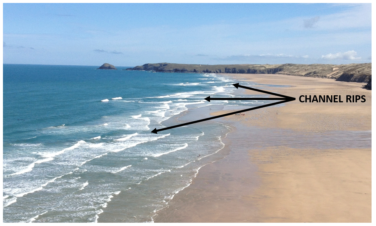
Figure 1Channel rips typically present as darker corridors of water between the whiter patches of breaking waves, as shown here at Perranporth Beach, UK. The rips occur in deeper channels which reduce or prevent wave breaking, hence the darker visual signature. The rip channels often look like the calmest or safest place to swim to inexperienced observers. Image credit: SP.
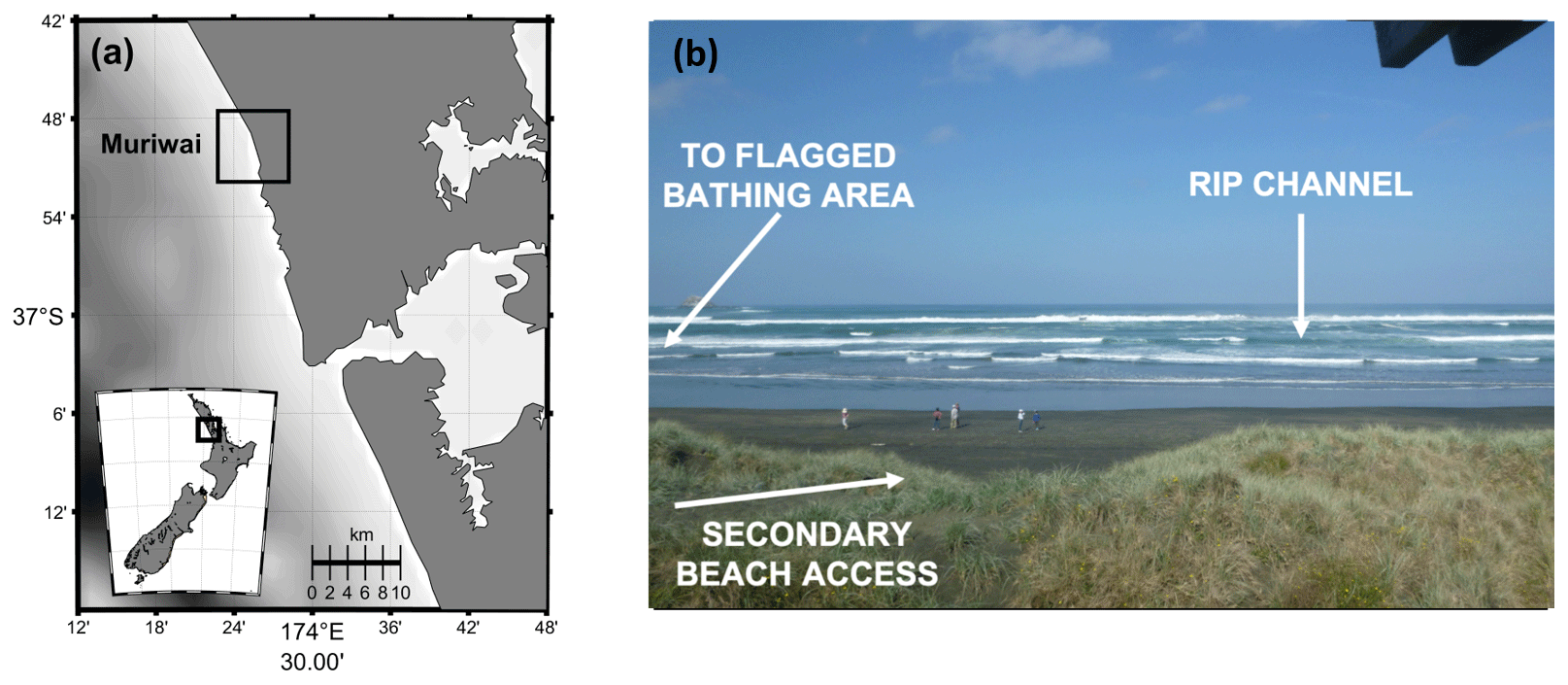
Figure 2(a) Study site map and (b) photograph of main channel rip next to bathing area used to test rip identification ability. The photograph is taken by the lifeguard tower next to a secondary access track linking the car park to the beach.
There are several initiatives and interventions employed around the world to mitigate the social aspects of rip current drowning risk. It is well established that lifeguards are the most effective method for drowning prevention on popular surf beaches (Gilchrist and Branche, 2016). However, the coverage of lifeguarding services varies spatially and temporally. Logistical and cost constraints, as well as seasonality of demand, mean it is not feasible for lifeguards to be present on all beaches and at all times. For example, in New Zealand there are 74 Surf Life Saving clubs spread around 15 000 km of coastline, and their patrol season typically only runs from October to April surrounding the austral summer. Furthermore, the lifeguard beach flag systems used globally are inconsistent, varying from the traffic light system approach of the US to the “swim between the red and yellow flag” system adopted by Australia, New Zealand, the UK, and some other countries. Beach safety signage is another commonly adopted mitigation method used to educate people about the rip current hazard, but the type and messaging involved vary globally. There is also evidence that signage at entry points to beaches goes unnoticed by a large proportion of beach users (Matthews et al., 2014) and that signage is often ineffective in communicating key messages to beachgoers (Brannstrom et al., 2015).
More recently, a number of dedicated national education campaigns have focussed specifically on rip current hazard interventions. For example, the US “Break the Grip of the Rip!” campaign (https://www.weather.gov/safety/ripcurrent, last access: 11 January 2021), which began in 2005, focussed on a wide range of factors, such as how rip currents operate, why they are dangerous, how to identify them, and how to escape them (Carey and Rogers, 2005), and this campaign has been shown to be somewhat effective (Houser et al., 2017). In Australia, several campaigns since 2009 have focussed on how to escape rip currents and how to identify them, and more recently the “Think Line” campaign has been adopted (http://www.beachsafe.org.au/surf-safety/ripcurrents, last access: 11 January 2021), in which beachgoers are urged to stop, observe, and think about what the hazards are when they got to a beach. Similarly, the UK has the “Respect the Water” campaign (http://www.respectthewater.com/, last access: 11 January 2021) which focuses more broadly on raising awareness of the wider dangers associated with coastal or ocean recreation. New Zealand has also recently released the three Rs (“Relax, Raise, Ride”) rip current campaign (http://www.findabeach.co.nz/besafe/hazards/rips/, last access: 11 January 2021) aimed at reminding people to remain calm and conserve energy in order to remain afloat whilst signalling for help, going with the current, and weighing up your options to get back to shore.
One of the key themes in many existing rip current safety campaigns has been attempting to teach people to identify a rip current. However, several studies have shown that even when people are aware of what rip currents are and why they are dangerous, they are largely unable to visually identify a rip current in a photograph. Caldwell et al. (2013) report the successful identification of channel rips to be lower than 20 %, with success rates of up to 40 % reported by Willcox-Pidgeon et al. (2017) and a 48 % success rate in selecting a safe place to swim reported by Sherker et al. (2010). A similar study by Surf Life Saving Australia (SLSA, 2019a) surveyed ocean swimmers who self-assessed as highly competent and reported that only 27 % were able to accurately identify rip currents in multiple photographs. Evidence suggests a similar trend in other rip current types, with a study by Brannstrom et al. (2014) reporting 31 % success when beachgoers were asked to identify a boundary-controlled rip current running along the edge of a groyne.
Rip identification is complicated by the fact that different rip current types or forcing conditions can create different visual signatures. For example, channel rips that form in deeper channels between sand bars (Castelle et al., 2016) generally present optically as an area of darker and calmer water due to a relative lack of wave breaking when compared to the shallow sandbars on either side (Fig. 1). Conversely, flash rips (Castelle et al., 2016) are not channelised but are instead generated by transient surf zone eddies resulting from vortical motions associated with short-crested breaking waves and are typically characterised by sediment-laden plumes of water extending offshore and a turbulent water surface. The wave–current interaction between incoming waves and the offshore rip current flow can also present visually as a rippled and bumpy water surface (Ménard et al., 2018).
The calm, smooth visual signature associated with channel rips is particularly important in terms of educating people about how to identify the hazard as inexperienced or uninformed beach users will often pick this calmer patch of water as the safest place to swim (Gallop et al., 2016) to avoid the breaking waves either side of the rip which are perceived as being more dangerous (Caldwell et al., 2013). Rip current visual signatures also vary as morphology, tidal stage, or wave energy changes (Pitman et al., 2016), meaning an observer might have to rely on different visual signatures for the same rip channel at different times during the day.
The ability to identify, and therefore avoid, a rip current is a critical skill for a beachgoer when making decisions about where and when to enter the water, particularly in the absence of lifeguards (Ménard et al., 2018). As demonstrated above, previous studies have shown that the existing rip current identification abilities of beachgoers is poor. However, in these studies, rip current identification by beachgoers has been based either on participants self-reporting on how confident they would feel at being asked to identify a rip current (Morgan et al., 2009a) or on asking people to directly identify rip currents in photographs taken from various perspectives (Moran, 2008; Caldwell et al., 2013; Brannstrom et al., 2015; Clifford et al., 2018) or to identify the safest place to swim in a photograph of a beach (Sherker et al., 2010; Gallop et al., 2016; Houser et al., 2017; Willcox-Pidgeon et al., 2017; Clifford et al., 2018; Fallon et al., 2018). However, Ménard et al. (2018) noted that a fundamental problem is the lack of research investigating whether an individual's ability to identify a rip or a safe swimming area in a photograph translates to an equal ability to identify a rip current in situ at the beach. Therefore, the aims of this study are to use a survey instrument to investigate (1) how an individual's demographic (e.g. gender, age, ethnicity) and beach competence (e.g. swimming ability and degree to which they are familiar with the surf zone) relates to their ability to identify a rip current in situ at a high energy beach and (2) whether the ability to identify a rip in a photograph translates to an equal ability to locate a rip in situ at a beach.
Table 1Question groups and example questions used in the survey of beach users
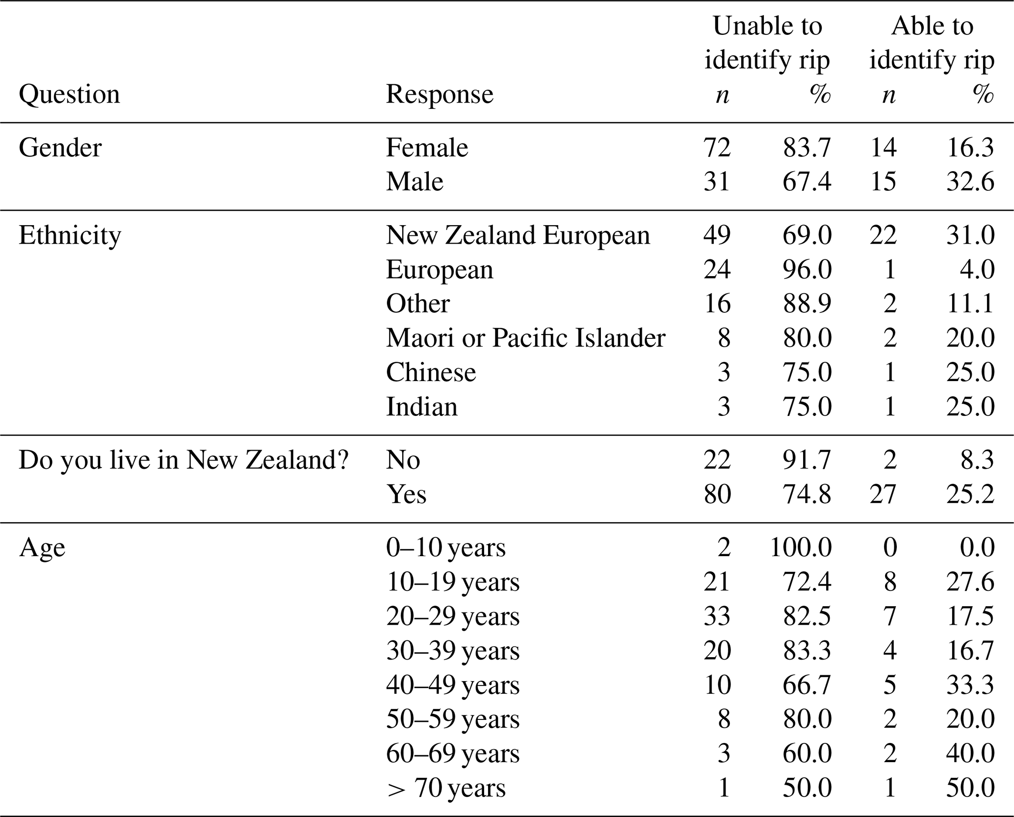
Table 2Sample characteristics in terms of demographics, frequency of beach visits, and self-rated pool swimming competency (n=132).
Table 3Respondents ability to identify an in situ rip based on their demographic (n=132).
2.1 Study site
The study site was Muriwai Beach (Fig. 2), a high-energy, dissipative, mesotidal beach on the exposed west coast of New Zealand's North Island. An analysis of wave hindcast data shows average significant wave height at Muriwai to be 2.1 m with a mean wave period of 10 s. Waves during the summer months are typically calmer than in winter but are interspersed with very high energy events associated with ex-tropical cyclone activity in the Tasman Sea. The surf zone typically exists in a double barred state with a dissipative outer bar and intermediate inner bar (Brander and Short, 2000). This site was selected for this study as it is a high-risk site for rip current rescues according to Surf Life Saving New Zealand (SLSNZ), with 530 such events recorded in the period 2007–2018, representing 80 % of beach lifeguard rescues at this site. Muriwai Beach is less than an hour's drive from New Zealand's largest city, Auckland (Fig. 2a), making it a popular destination for both domestic visitors and foreign tourists. An analysis of lifeguard head count data shows that visitor numbers at Muriwai Beach typically exceed 80 000 per month in the peak summer period. During the study period, lifeguards patrolled a safe bathing area indicated by a pair of red and yellow flags located between a headland at the southern end of the beach and a prominent channel rip to the north of the bathing area in front of the lifeguard tower (Fig. 2b). This rip channel was static throughout the 7 d study period. The breaking wave heights over the study period (estimated from latest surf forecasts at the time) varied between 1.5 and 3 m. Our own analysis of lifeguard rescue data shows a disproportionate number of rip-related rescues occurred when breaking wave heights were between 1.5 and 2.5 m. Therefore, the conditions during the study were representative of those who are of greatest concern to lifeguards in respect to rip current rescues.
2.2 Beach user survey
The research relied on a survey instrument completed by a convenience sample of various beach users who were either on the beach directly onshore from the channel rip evident in Fig. 2b or in the flagged bathing area adjacent to it. The survey was approved by the University of Canterbury human ethics committee (2018/97/LR) and conducted over a 7 d period between Tuesday 15 and Monday 21 January 2019 (austral summer). Beach visitor numbers in mid-January are representative of the wider season typically averaging around 100 people at any given time during the week and 800 during the weekend. Visitation numbers steadily increase towards the second week of February, peaking at around 2500 at any given point over the weekend. Potential participants for this study were approached by the investigator if they were settled on the beach (i.e. not if they had just got there or were just leaving) and if they appeared to have no supervisory duties such as watching young children in the water. The survey took less than 10 min to complete, with participants self-completing their answers on a paper form (see Supplement). Additionally, one follow-up question was presented verbally by the investigator, in which the participants were asked whether they could see any rip currents at this site and, if so, to point towards and describe the location. The survey consisted of 34 questions grouped broadly into basic demographic questions (gender, age, ethnicity, and a question to identify whether the individuals were locals, wider New Zealand residents, or international visitors), as well as questions to ascertain how the participants spend their time at the beach, their swimming ability, and their understanding of rip current hazards. Answers fields in the survey made use of a combination of (1) categorical tick boxes for questions about demographics, swimming ability, and type of activity undertaken. (2) five-point Likert scales for questions addressing self-reported confidence in dealing with hazards, and (3) open text fields to understand the depth and breadth of knowledge of the participants with respect to different hazards. A selection of example questions is outlined in Table 1, and the full questionnaire is included as Supplement.
This survey used protection motivation theory (PMT; Rogers, 1975) to investigate rip current hazard perception, in line with previous water-based studies of competency (McCool et al., 2008, 2009; Moran et al., 2011, 2018; Moran and Willcox, 2013; Willcox-Pidgeon et al., 2018). The use of PMT allowed us to quantify and compare the self-reported perceptions of water competence (including swimming and floating competency) vs. the perceptions of risk in the surf zone. Water competence (as opposed to swimming ability) refers to a broad set of skills important in drowning prevention, with a full review of water competencies provided by Stallman et al. (2017). Participants were first asked if they could swim (yes/no) and, if they answered yes, were then asked to rate their ability on a four-point scale from poor to very good. This was then quantified using questions asking how far they could swim in a pool, how confident they felt swimming that same distance at the beach, and when they last swam that distance. This was followed with basic competence questions identifying their perceived ability to float and/or swim effectively on both their front and back and their ability to tread water for 2 min.
Respondents were then asked open questions about how they select safe areas to swim at the beach, when and why they might choose to swim outside of the flagged bathing area, what hazards may occur at the beach, and which hazards they have personally experienced (Table 1). They were then specifically asked about rip currents, such as what makes a rip current dangerous, how confident they feel about escaping a rip current, whether they have any experience of being caught in a rip, and the actions they would take to escape. Finally, we quantified their ability to identify rip currents using two photographs (shown in Fig. 3), a method modified from that of Caldwell et al. (2013). Participants were asked to draw an “x” on the photograph to denote the location of the rip current. In assessing whether the answer was correct, the investigator would check that the centre of the x mark corresponded to the darker area of the rip channel. Participants were then asked to identify a rip current on the beach in front of them. Participants were not told whether or not their on-paper rip identification was correct or not prior to attempting in situ identification such that their knowledge base was the same for both sets of identifications. The presence of an active in situ rip current was decided by consultation between a senior lifeguard and the investigator who is experienced in surf zone dynamics, and, provided both agreed that a channel rip was present and visible at the time of the survey, the question was asked of the participant. In addition to pointing, in order to verify their answer and ensure accurate recording, participants were asked to describe the area in which they believed the rip to be located. Some participants responded by describing visual surf zone clues (e.g. the gap in the breaking waves) and some with landmarks (e.g. in front of the lifeguard tower) or distances (e.g. approximately 100 m down the beach). Examples of times when the question was not asked include mid- to high tide, when there was insufficient wave breaking on the inner bar to establish rip current circulation, or if the participant refused. If the participant was unsure how to identify the rip or incorrectly identified an area where no rip was present, the response was marked as incorrect.
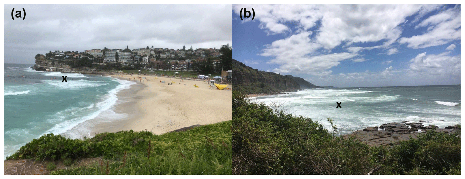
Figure 3Images from (a) Bronte Beach and (b) Coalcliff Beach in New South Wales, Australia, were used for checking participants' ability to identify rip currents. These were chosen as they contained rip channels that presented visually as darker areas between breaking waves, which is similar to the rip current present at the study site during the surveys. Participants were asked to mark with an “x” any area they thought there was a rip; an example identification is shown above. Photograph credits: (a) Walkingmaps.com.au; (b) Rob Brander.
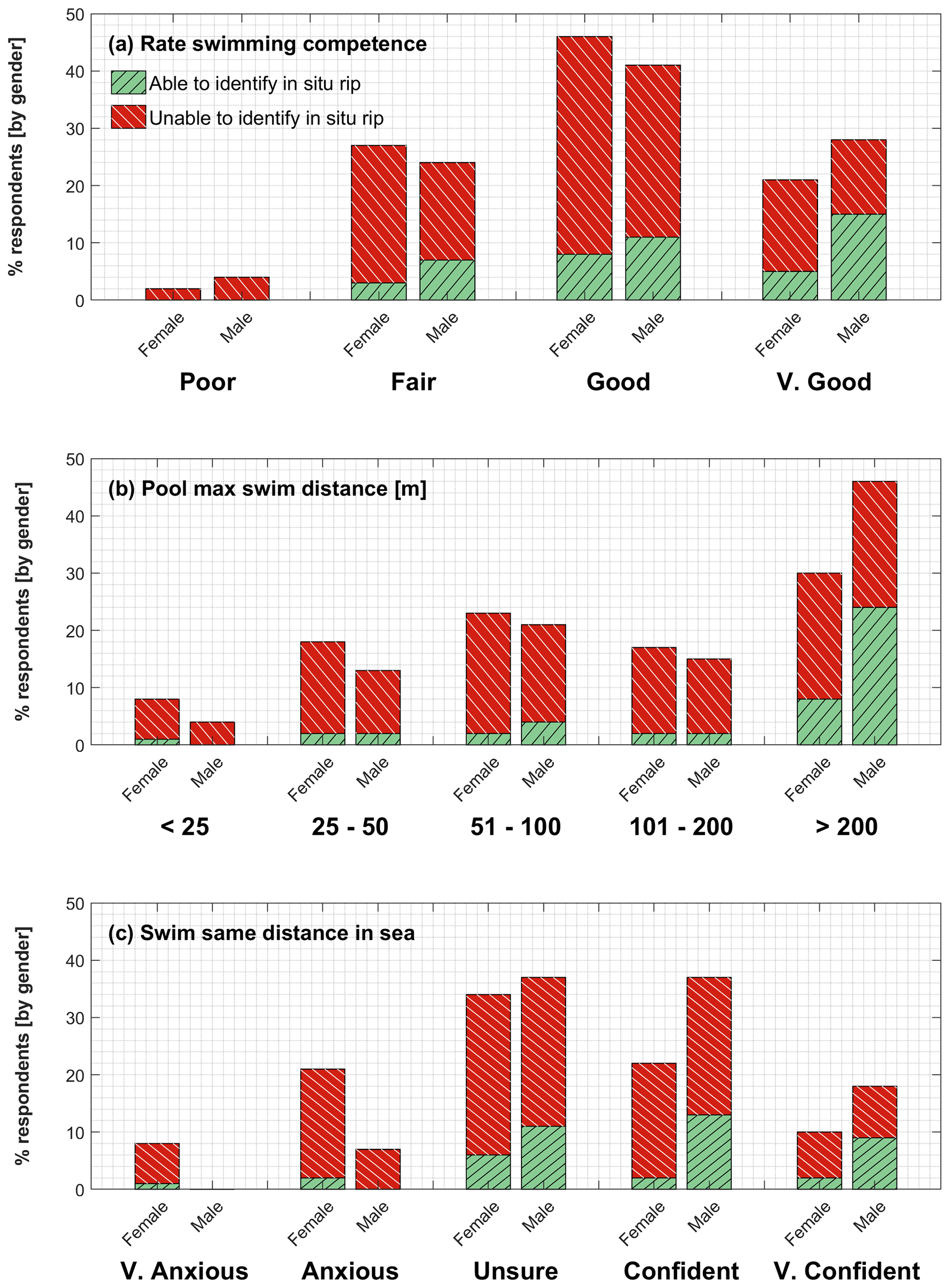
Figure 4Respondents' ability to identify the in situ rip current as a function of (a) their self-reported swimming competence, (b) the maximum distance they reported being able to swim in a pool non-stop, and (c) their feeling at being asked to swim the same distance in the sea. Responses are broken down by gender, with green bars indicative of the percentage of respondents able to identify the in situ rip and red bars indicative of those who cannot.
There were 132 surveys conducted whilst the rip current was active and displaying a visual signature that could be observed from the beach. Descriptive statistics for the sample are provided in Table 2. The sample population is gender-imbalanced, with 65 % of respondents being female. Although refusals were not recorded, our investigator qualitatively noted that a higher proportion of young males refused to participate. A total of 54 % of the sample were New Zealand European, 17 % were European, and 8 % were Mori or Pacific Islander. A total of 3 % of respondents were Chinese, 3 % were Indian, and the remaining 15 % were a combination of “Other” nationalities. A total of 81 % of respondents were living in New Zealand, with 18 % representing holidaymakers or short-term visitors, and 31 % of respondents classified the survey site as their local beach. A total of 74 % of respondents indicated that they go to the beach at least once a week, with 13 % indicating they usually visit every day. Respondent age was recorded in discrete groups, with the modal group being 20–29 years (30 %). A total of 22 % were aged between 10 and 19 years, 18 % were 30–39 years, and 11 % were 40–49 years. A total of 75 % of the sample indicated that they could swim in excess of 50 m in a pool.
3.1 Demographic trends in rip identification ability
A total of 78 % of respondents (n=103 of 132) were unable to identify the in situ rip current. Table 3 shows how reported demographics influence the ability to identify the in situ rip. A significantly higher proportion of males (33 %, n=15 of 46) than females (16 %, n=14 of 86) were able to identify the rip (χ2=4.66, p=0.03). New Zealand Europeans had the highest successful rip identification rate (31 %, n=22 of 72). Chinese and Indian respondents both had a 25 % success rate, but the sample size for each ethnicity was only four. Mori and Pacific Islanders had a 20 % (n=2 of 10) success rate. The success rate was higher for New Zealand residents (25 %, n=27 of 107) than visitors (8 %, n=2 of 24). No specific trends were evident with regard to respondent's age and ability to identify the rip current. Most drowning literature identifies those under 30 as being most likely to be involved in a rip current rescue. When grouped here, those 29 and under had a success rate of 21 % (n=15 of 71), and those 30 and over had a success rate of 25 % (n=14 of 56), again showing no significant difference.
Table 4Self-reported swimming competency, broken down by the percentage of male and female respondents. The value in brackets was an assigned numerical value to aid the statistical analysis of responses.

NB. Totals may not equal 100 % due to non-responses.
3.2 Self-reported swimming competence
Respondents were asked to self-rate their swimming competency through a series of questions (Table 4), with each response assigned a numerical value between 1 and 5 representing increasing competence. When asked to rate on a qualitative spectrum (“Poor”, “Fair”, “Good”, “Very Good”), 70 % of respondents (n=90 of 129) replied either “Good” or “Very Good” and there was no significant difference between genders. No significant difference was evident when ability to identify an in situ rip was analysed against self-reported estimates of swimming competence (Fig. 4a). In order to qualify self reported competence, respondents were subsequently asked to estimate their maximum pool swimming distance. In response, 47 % of females reported being able to swim in excess of 100 m compared to 61 % of males. A Mann–Whitney U test indicated maximum pool swim distance was significantly higher (median =5, “200 + m”) among those who could identify a rip current compared to those who could not (median =3, “51–100 m”) (p=0.006). Across all classes, self-reported confidence about swimming that same distance at sea was significantly greater among males (median =4, “Confident”) than females (median =3, “Unsure”) (p=0.004).
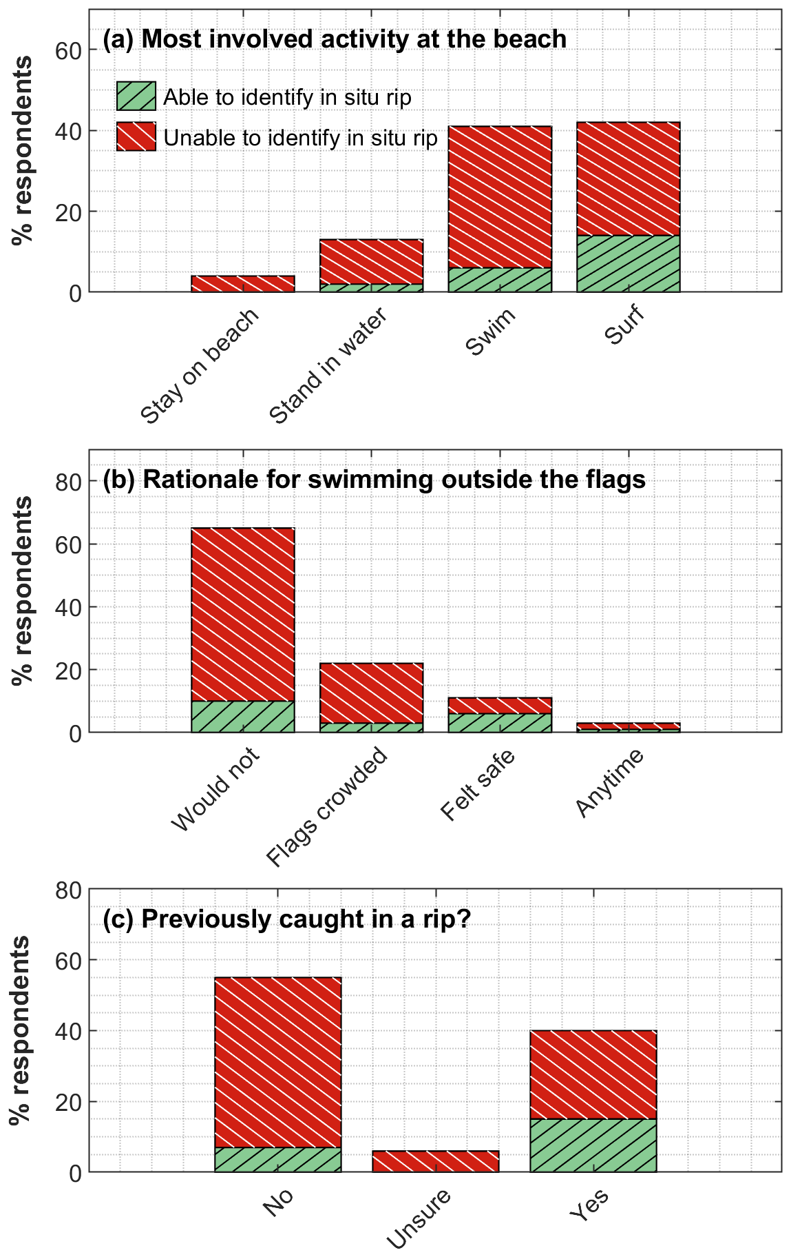
Figure 5(a) Respondents' activity at the beach, (b) rationale for swimming outside of the flagged bathing area, and (c) indication of those who have experience of being caught in a rip. Green bars are indicative of the number of respondents able to identify the in situ rip, and red bars are indicative of those who cannot.
3.3 Familiarity, behaviour, and experience
The questionnaire was able to ascertain how familiar people were with the study site and what degree of interaction they had with the water. Of the 29 people able to identify the in situ rip current, 27 (93 %) lived in New Zealand. A total of 22 (92 %) of the 24 people who lived overseas were unable to identify the rip. A total of 12 (41 %) of the 29 people able to identify the rip classed Muriwai as their local beach, which equated to a 29 % success rate among locals (n=12 of 41).
Respondents were asked to state all activities they participate in at the beach, and these were ranked according to increasing interaction with the surf zone, from those who remain on the beach, those who enter the water but remain in water shallow enough that they can stand, those who swim beyond their depth, to those who surf or body board (Fig. 5a). Of the 29 respondents able to identify the rip current, the largest proportion (62 %, n=18 of 29) were in the surfing and body boarding group, followed by swimmers (28 %, n=8 of 29) and those who remain within their depth in the water (10 %, n=3 of 29). Of the five respondents who reported never entering the water at the beach, none were able to identify the rip current, although four out of the five did rate themselves as fair or good swimmers, so their decision to not enter the water did not appear to be a reflection of their perceived low swimming competence. In the swimming group, 85 % (n=46 of 54) of respondents were unable to identify the rip, as were 67 % (n=37 of 55) of the surfers and body boarders.
When questioned on whether they would swim outside of the flagged bathing area, 35 % (n=36 of 102) of respondents indicated that they would at times swim outside of the patrolled area at the beach. Of these respondents, 72 % (n=26 of 36) were also unable to identify the rip current (Fig. 5b). The reasons given for swimming outside the patrolled area were that the flags were too crowded (61 %, n=22 of 36), they felt able to choose a safe place to swim (31 %, n=11 of 36), or they did not have a specific reason and would do so at any time (8 %, n=3 of 36). The most competent subgroup in terms of rip identification ability were those who felt they could identify a safe place to swim, in which 6 of the 11 (55 %) were able to identify the rip. There was no statistically significant difference in rip spotting ability between those who chose to swim outside the flags and those who would not, although it does appear that many of those with less knowledge may choose to remain between the flags. Across the entire dataset, the majority of respondents (55 %, n=68 of 124) indicated that they had not been caught in a rip before, and of these, 87 % (n=59 of 68) were unable to identify the rip (Fig. 5c). Of the 49 respondents who had experienced being caught in a rip, only 37 % (n=18) were able to identify the in situ rip.
3.4 Photograph vs. in situ identification
An implicit assumption of previous studies relating to rip identification is that the ability to identify a rip current in a photograph translates to an ability to identify rip currents in situ. In this study, 31 % (n=41 of 132) of respondents were able to identify a rip in both photographs in Fig. 3, 26 % (n=34 of 132) could identify a rip in only one photograph, and 43 % (n=57 of 132) were unable to identify a rip in either photograph. Figure 6 identifies the success rate of in situ rip identification as a function of a participant's ability to identify rips in the photographs. Of the participants who were unable to identify a rip current in either of the images presented in Fig. 3, 89 % (n=51 of 57) were unable to identify the in situ rip. Of those able to identify the rip in only one of the images in Fig. 3, 74 % (n=25 of 34) were unable to identify the rip in situ, and of those able to identify rips in both images in Fig. 3, only 34 % (n=14 of 41) were able to identify rip currents in situ (Fig. 6). The significance of the relationship between in situ and photograph-based ability was tested using a linear regression, in which the ability to identify a rip in situ was coded as a binary outcome, and the number of rips identified on paper was used as a continuous predictor. The number of rips identified in photographs was a statistically significant (p=0.004) coefficient in the prediction of a participant's ability to identify in situ rips. Despite this statistical significance, it is important to acknowledge that approximately two thirds of respondents who were able to identify both rip currents in photographs were unable to do so in situ at the beach (Fig. 6).
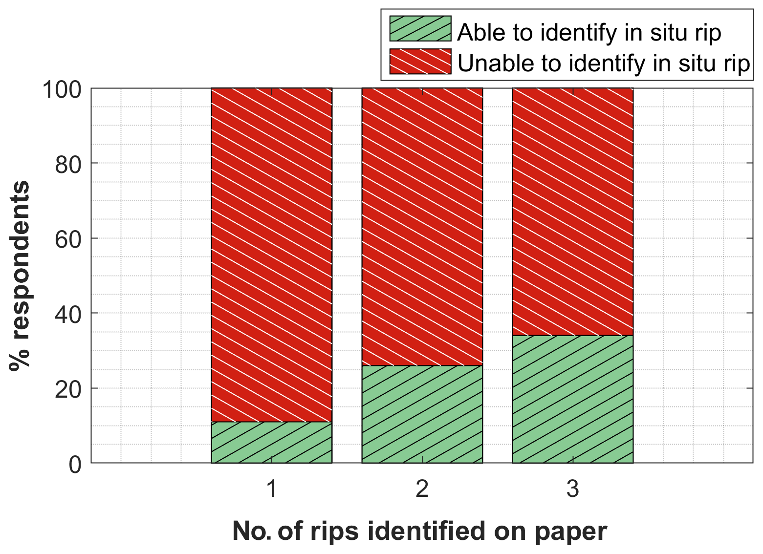
Figure 6The percentage of respondents able to identify the in situ rip (green bars) vs. those unable to identify the in situ rip (red), presented as a function of their ability to identify rips on paper.
This study, to our knowledge, represents the first attempt to quantitatively evaluate the ability of beachgoers to visually identify an actual rip current on a beach. Only 22 % of surveyed beachgoers were able to successfully identify a channel rip at a high energy beach at Muriwai, New Zealand. Here we discuss the results of our study in the context of existing literature in regards to both beachgoer demographics and implications towards beach safety.
4.1 Demographic trends in rip identification ability
Males are generally over-represented in rip-related rescue statistics (Woodward et al., 2013) and global drowning epidemiology more generally (Peden and McGee, 2003), and PMT shows them to be more likely to overestimate their ability and underestimate the risk they are in with regard to water-related recreation (Moran, 2011). In the current study, males generally self-reported higher competence with men significantly more likely to report feeling confident at the prospect of swimming their maximum pool distance at sea. This compares well to previous studies that have identified higher self-reported confidence among males, which likely increases drowning risk exposure through reduced inhibitions about deep water swimming or challenging conditions (Morgan et al., 2009a). Males were better able to identify the rip current, but this result was not controlled for other factors such as experience or familiarity with the beach in question. It is possible that the correlation with gender is linked to the fact that males are more likely to use surf equipment and swim further from the shore (Morgan et al., 2009b), and therefore they are more likely to have frequently interacted with rip currents. A previous New Zealand study reported 53 % of males felt confident identifying rip currents compared to 39 % of females, but it did not report on their actual success rate (Moran and Ferner, 2016). Other studies addressing the impact of gender on the ability to identify a rip have had contrasting outcomes. For example, males at Miami Beach, USA, were more successful in identifying a safe location to swim (Fallon et al., 2018), whereas females were more successful in an Australian study (Williamson et al., 2012). Higher self-reported competence across both genders was linked to increased ability to identify the rip current in our study.
Respondents who undertook beach activities in which they physically interacted more with the surf zone, such as swimming and surfing, were more likely to be able to identify the rip current. Surfing as an activity is associated with the type of coastline where many hazards may exist, such as larger waves and stronger rips. Therefore, surfers likely have a much higher understanding of rip currents (Attard et al., 2015), especially as surfing is often prohibited in the flagged bathing area which increases the likelihood of interacting with a rip current. Moreover, many surfers actively use rip currents to get out beyond the breakers with minimal effort, and are therefore more adept at identifying them. Prior experience of being involuntarily caught in a rip (as opposed to choosing to use one) was also a factor in whether a person could identify the rips in this study. This was consistent with an Australian study of rip current survivors showing that 84 % of those people who had previously been caught in a rip current were now able to identify rips in photographs (Drozdzewski et al., 2012). In our study, only 37 % of rip current survivors were able to identify the in situ rip, which highlights the additional complexity and skill required when considering an active and fluid surf zone rather than a static photograph. This was evidenced in the study by Sherker et al. (2010), in which 93 % of respondents indicated they could identify a rip when in reality less than two thirds of the respondents could actually identify the channel rip in a photograph.
4.2 Implications for beach safety
As mentioned previously, only 22 % of surveyed beachgoers in this study were able to identify a real rip current. Furthermore, 66 % (n=27 of 41) of the surveyed beachgoers who were able to successfully identify rip currents in two photographs (Fig. 3) were unable to identify the channel rip present at Muriwai Beach. These findings have significant implications for beach safety practitioners on several levels. First, the ability to correctly identify rip currents on paper (i.e. still images) may result in overconfidence of actual rip identification ability and therefore may lead to more risk taking behaviour, such as swimming away from lifeguards or in unpatrolled locations. Anecdotal evidence from Surf Life Saving Australia (Shane Daw, personal communication, 2019) showed an increase proportion of rescues of people who were considered educated and informed about rip currents following recent education campaigns, who, armed with this information, were now over-predicting their ability to identify, avoid, and escape rip currents and under-predicting the risk.
Second, it suggests that the ability of beachgoers to identify rip currents may be worse than previously shown in the literature. The main methodological approach in previous studies has been either to directly ask surveyed participants to identify a rip current in an image (e.g. Brannstrom et al., 2014; Clifford et al., 2018) or to ask them to identify the safest place to swim (e.g. Sherker et al., 2010; Gallop et al., 2016; Warton and Brander, 2017) in an image that contained a rip current. The ability of beachgoers to specifically identify rip currents has generally resulted in successful identification rates of less than 30 %. Caldwell et al. (2013) reported that less than 20 % of participants were able to identify the channel rip in a series of images of Pensacola Beach, Florida, under green, amber, and red flag conditions, with many instead thinking the rip current was present in the heavy surf which was instead indicative of shallower depths and wave breaking. Brannstrom et al. (2014) showed multiple images of a groyne at Galveston Beach, Texas, under different wave conditions and asked participants to identify the most hazardous conditions to swim in. Only 13 % of respondents identified the image with the boundary rip current, with the majority instead also opting for images of wave breaking. Similar results have been obtained from studies asking participants to identify safe swimming locations. Sherker et al. (2010) showed that 52 % of primarily Australian respondents chose a rip current as the safest place to swim in an image, while 40 % did so in the UK-based study of Gallop et al. (2016), and 73 % chose a rip current as the safest place in at least one of the two images they were shown in a study at Miami Beach, Florida, by Fallon et al. (2018). While our finding that only 22 % of respondents could identify the in situ rip is therefore at the lower end of values previously reported using photographs, the fact that 66 % of respondents who could identify rip currents in photographs (Fig. 3) but could not identify the actual rip current is of significant concern.
Third, our results suggest that the use of still images may not be an effective method to utilise in future research related to rip current identification. The selection of rip current images to use research surveys ultimately relies on subjectivity (Ménard et al., 2018). Often the rip current is centred in these images and thus clearly the focal point of the image, perhaps leading to increased identification bias. The survey design may also lead to participants trying to figure out the “correct” answer, perhaps based on text in previous questions or by obvious visual cues in the image, rather than providing an accurate overview of their perception of the hazard (Ménard et al., 2018). Researchers will often provide static images in which the rip current is obvious based on these visual cues or taken from an elevated position to enhance the visualisation of the rip (e.g. Fig. 3) instead of from the beach or shoreline level, which is a more realistic viewpoint for someone making a decision on where to enter the water. This reinforces the findings of a study by Brannstrom et al. (2015) which showed that a warning sign with a graphical representation of a rip current portrayed from an aerial view was useful in teaching people what to do if caught in a rip (swim parallel) but was not a useful means of helping people to identify a rip in situ. This goes some way to explain the disconnect outlined in this study between purely photograph-based identifications (57 % able to identify a rip in at least one image) and the translation of that ability into meaningful in situ identification at the beach, where only 22 % of respondents could identify the rip. The reality is that the surf zone is spatially and temporally dynamic, and it often takes a prolonged period of observation to successfully identify rip currents. Identifying a rip current in a well-defined snapshot image vs. in situ requires different skills and timeframes, and rarely do beachgoers seek an elevated position from which to observe rips prior to entering the water. Ultimately, if photographs are to be used in further studies of rip identification, they should be site-specific and taken from a realistic beach perspective to ensure that beachgoers can situate themselves in place rather than being asked to interpret a photograph taken from a viewpoint that bears no resemblance to the viewpoint afforded to them on the beach (Brannstrom et al., 2015; Ménard et al., 2018). The next logical step is to understand how ability to identify an in situ rip current is affected by spatial variations in perspective on the beach. Therefore, future studies should aim to identify how factors such as distance and the orientation of the viewpoint relative to the main channel direction impact upon beachgoers' ability to identify the rip.
Finally, our findings suggest that more work is required to investigate whether photographs are actually a useful medium for rip current education campaigns given the disconnect between successful identifications in photographs and real life. One potential solution to this problem is to make use of the increasing availability of video footage of rip currents on social media, such as YouTube (Mackellar et al., 2015), and the rapidly increasing development and availability of 3-D headsets and virtual reality, whereby people (e.g. school children) could interact with a “live” and dynamic surf zone, including rip currents. These approaches are already being taken for water safety education in New Zealand (DPA, 2018) but are yet to be used for quantitative analysis of surf zone hazard perception. Additionally, one approach gaining traction as a successful way of allowing people to visualise the rip current is the release of harmless dyes as a tracer (Brander et al., 2014) either in person or in video footage. The benefit here is that people have the opportunity to try and identify the rip current before, during, and after the dye release. As the dye fades, onlookers can try to look for the natural rip channel signature (i.e. darker gaps between breaking waves) and learn to associate this with the presence of a rip current.
4.3 Limitations
One of the limitations of this study is that it was conducted at a lifeguarded beach during guarded hours, and therefore there was a flagged bathing area which was signposted as a safe place to swim. Thus, respondents may automatically have associated the area outside of the flags to be dangerous, which potentially aided them in identifying the rip. As this study was conducted in situ, familiarity with the beach may also have played a role in rip identification, with 31 % of respondents identifying Muriwai as their local beach. These individuals may have been reliant on previous knowledge of the beach to identify the likely rip location, which does not necessarily mean they would be able to identify a rip at an unfamiliar site. This may go some way towards explaining how some people who identified no rip currents in photographs were able to identify the in situ rip. In the current study, 93 % (n=27) of the successful in situ identifications were made by people who lived in New Zealand, and 41 % (n=12) of the successful identifications were made by individuals who classed Muriwai as their local beach. This study still represents an accurate depiction of a given beach population's ability to identify the rip as beaches typically have a mix of visitors and locals with varying site-specific knowledge. Previous studies have shown that 40 % of international visitors to New Zealand identified swimming at the beach as their most popular recreational activity whilst on holiday (Moran and Ferner, 2016). Perhaps more significant in this study was the higher proportion of refusals to participate from young males. This is particularly pertinent as this demographic has been identified as at risk in the global drowning literature (Woodward et al., 2013) and identified as a group more likely to overestimate ability and underestimate risk (Moran, 2011). Therefore, more work needs to be done to understand whether the previously reported underestimation of risk is at all linked to an (in)ability to identify rip currents.
The surf zone is inherently dynamic due to factors such as tidal stage, individual wave sets, or changes in wind strength/direction which all influence the degree to which the rip current was visible. As the surveys were conducted at different times across 7 different days, the appearance of the channel rip current may have changed despite remaining in a persistent location during the study period. Therefore, each respondent formulated their answer from slightly different viewpoints combined with different conditions. This study did not account for how viewing orientation, distance from the rip, or instantaneous hydrodynamic conditions impacted the ability to identify the rip. Any future in situ study should plan to incorporate some form of wave/tide measurement and a coastal imaging camera in order to make comparisons between identification rates and wave/tide heights and breaking wave patterns, as well as record observation locations relative to the rip. One potential alternate solution to this problem is to make use of the increasing availability of 3-D headsets and virtual reality, whereby each respondent could still interact with a “live” and dynamic surf zone, but the experiment could be better controlled such that each participant was given the exact same stimulus from which to formulate a response. Indeed, other studies have advocated for the use of video (Hatfield et al., 2012; Wilks et al., 2017) as a more appropriate means of visualising a rip current, and this would perhaps also allow for a more controlled measure of rip identification ability. Nevertheless, this study replicates the real-world conditions that people face when making decisions on the beach and demonstrates that the selection of a safe place to swim without prolonged observation could equally result in the inadvertent selection of the rip current. This further highlights the difficulty in educational approaches in which the main aim is to teach people to identify the rip currents given that conditions (and the visibility of the rip) change dramatically within a site during the course of a day, let alone between sites.
Previous studies have reported rip identification rates based on respondents looking at photographs of rip currents rather than rip currents in situ. This study represents the first attempt to examine relationships between an individual's beach experience, their ability to identify a rip in a photograph, and if this translated into an equal ability to locate a rip in situ at the beach. Overall, 78 % of people were unable to identify a rip current at Muriwai, a high energy beach in New Zealand known for its pronounced channel rip currents. Respondents that were able to identify rip currents in photographs were better able to identify the in situ rip current, but the majority of that group (66 %) were still unable to translate this into a meaningful identification of the in situ rip. Individuals that actively swim or surf at the beach were better able to identify rips when compared to those who never entered the water or those who only waded in shallow water depths. Likewise, those who self-reported an increased water competence or those who had previously been caught in a rip current, were also more likely to be able to identify the in situ rip.
These results have major implications for the future use of photographs to assess beachgoers' ability to identify rip currents and for future rip current education strategies involving rip current identification. Many education programmes use static imagery to “teach” people to identify rip currents, but this study presents clear evidence that this skill does not translate usefully into in situ rip identification. Future work should consider whether employing immersive 3-D/virtual reality technologies and videos of actual rip current footage to present people with a dynamic surf zone would be a better means of educating people to identify rip currents.
Data will be made available upon request.
The supplement related to this article is available online at: https://doi.org/10.5194/nhess-21-115-2021-supplement.
SP, DH, KM, and AW conceived the research. KT created the questionnaire, conducted the fieldwork, and transcribed the data. SP conducted data analysis, guided by discussions with SG, RB, and KM. SP created the figures and drafted the initial manuscript. All authors provided critical feedback and contributed to revisions and rewrites of the manuscript.
The authors declare that they have no conflict of interest.
Our thanks to Wayne Stephenson and one anonymous reviewer for their constructive comments that strengthened this paper. Our thanks to the Muriwai lifeguards who hosted the research and provided consultation throughout the survey period.
Katie Thompson was funded by a University of Canterbury Summer Scholarship, co-funded by Surf Life Saving New Zealand.
This paper was edited by Pascal Haegeli and reviewed by Wayne Stephenson and one anonymous referee.
Attard, A., Brander, R. W., and Shaw, W. S.: Rescues conducted by surfers on Australian beaches, Accident Anal. Prev., 82, 70–78, https://doi.org/10.1016/j.aap.2015.05.017, 2015. a
Brander, R. and MacMahan, J.: Future challenges for rip current research and outreach, in: Rip Currents: Beach safety, physical oceanography, and wave modelling, edited by: Leatherman, S. and Fletemeyer, J., CRC Press, Florida, USA, 1–26, 2011. a
Brander, R. and Short, A.: Morphodynamics of a large-scale rip current system at Muriwai Beach, New Zealand, Mar. Geol., 165, 27–39, 2000. a
Brander, R. and Scott, T.: Science of the rip current hazard, in: The Science of Beach Lifeguarding, edited by: Tipton, M. J. and Wooler, A., CRC Press, Boca Raton, Florida, 67–84, 2016. a
Brander, R. W., Drozdzewski, D., and Dominey-Howes, D.: “Dye in the Water”: A Visual Approach to Communicating the Rip Current Hazard, Sci. Commun., 36, 802–810, https://doi.org/10.1177/1075547014543026, 2014. a
Brannstrom, C., Trimble, S., Santos, A., Brown, H. L., and Houser, C.: Perception of the rip current hazard on Galveston Island and North Padre Island, Texas, USA, Nat. Hazards, 72, 1123–1138, https://doi.org/10.1007/s11069-014-1061-3, 2014. a, b, c
Brannstrom, C., Lee Brown, H., Houser, C., Trimble, S., and Santos, A.: “You can't see them from sitting here”: Evaluating beach user understanding of a rip current warning sign, Appl. Geogr., 56, 61–70, https://doi.org/10.1016/j.apgeog.2014.10.011, 2015. a, b, c, d
Brewster, B. C., Gould, R. E., and Brander, R. W.: Estimations of rip current rescues and drowning in the United States, Nat. Hazards Earth Syst. Sci., 19, 389–397, https://doi.org/10.5194/nhess-19-389-2019, 2019. a
Caldwell, N., Houser, C., and Meyer-Arendt, K.: Ability of beach users to identify rip currents at Pensacola Beach, Florida, Nat. Hazards, 68, 1041–1056, https://doi.org/10.1007/s11069-013-0673-3, 2013. a, b, c, d, e
Carey, W. and Rogers, S.: Rip Currents – Coordinating Coastal Research, Outreach and Forecast Methodologies to Improve Public Safety, in: Solutions to Coastal Disasters 2005, American Society of Civil Engineers, Reston, VA, 285–296, https://doi.org/10.1061/40774(176)29, 2005. a
Castelle, B., Scott, T., Brander, R. W., and McCarroll, R. J.: Rip current types, circulation and hazard, Earth-Sci. Rev., 163, 1–21, https://doi.org/10.1016/j.earscirev.2016.09.008, 2016. a, b, c, d
Clifford, K. M., Brander, R. W., Trimble, S., and Houser, C.: Beach safety knowledge of visiting international study abroad students to Australia, Tourism Manage., 69, 487–497, https://doi.org/10.1016/j.tourman.2018.06.032, 2018. a, b, c
DPA: Drowning Prevention Auckland: Water Safety for Youth and Young Adults, available at: https://www.watersafe.org.nz/courses/youth-and-young-adults/ (last access: 11 January 2021), 2018. a
Drozdzewski, D., Shaw, W., Dominey-Howes, D., Brander, R., Walton, T., Gero, A., Sherker, S., Goff, J., and Edwick, B.: Surveying rip current survivors: preliminary insights into the experiences of being caught in rip currents, Nat. Hazards Earth Syst. Sci., 12, 1201–1211, https://doi.org/10.5194/nhess-12-1201-2012, 2012. a
Fallon, K. M., Lai, Q., and Leatherman, S. P.: Beachgoer's recognition of rip current hazard at Miami Beach, Florida, Ocean Coast. Manage., 165, 63–70, https://doi.org/10.1016/J.OCECOAMAN.2018.08.011, 2018. a, b, c
Gallop, S., Woodward, E., Brander, R., and Pitman, S.: Perceptions of rip current myths from the central south coast of England, Ocean Coast. Manage., 119, 14–20, https://doi.org/10.1016/j.ocecoaman.2015.09.010, 2016. a, b, c, d
Gallop, S. L., Bryan, K. R., Pitman, S. J., Ranasinghe, R., Sandwell, D. R., and Harrison, S. R.: Rip current circulation and surf zone retention on a double barred beach, Mar. Geol., 405, 12–22, https://doi.org/10.1016/j.margeo.2018.07.015, 2018. a
Gilchrist, J. and Branche, C.: Lifeguard effectiveness, in: The Science of Beach Lifeguarding, edited by: Tipton, M. J. and Wooler, A., CRC Press, Boca Raton, FL, USA, 29–35, 2016. a, b
Hatfield, J., Williamson, A., Sherker, S., Brander, R., and Hayen, A.: Development and evaluation of an intervention to reduce rip current related beach drowning, Accident Anal. Prev., 46, 45–51, https://doi.org/10.1016/j.aap.2011.10.003, 2012. a
Houser, C., Trimble, S., Brander, R., Brewster, B. C., Dusek, G., Jones, D., and Kuhn, J.: Public perceptions of a rip current hazard education program: “Break the Grip of the Rip”, Nat. Hazards Earth Syst. Sci., 17, 1003–1024, https://doi.org/10.5194/nhess-17-1003-2017, 2017. a, b
Mackellar, K. M., Brander, R. W., and Shaw, W. S.: YouTube Videos and the Rip Current Hazard: Swimming in a Sea of (Mis)information, Int. J. Aquat. Res. Educ., 9, 10, https://doi.org/10.25035/ijare.09.03.10, 2015. a
MacMahan, J. H., Thornton, E., and Reniers, A.: Rip current review, Coast. Eng., 53, 191–208, https://doi.org/10.1016/j.coastaleng.2005.10.009, 2006. a
Matthews,B., Andronaco, R., and Adams, A.: Warning signs at beaches: Do they work?, Safety Science, 62, 312–318, https://doi.org/10.1016/j.ssci.2013.09.003, 2014. a
McCool, J., Ameratunga, S., Moran, K., and Robinson, E.: Taking a risk perception approach to improving beach swimming safety, Int. J. Behav. Med., 16, 360–366, https://doi.org/10.1007/s12529-009-9042-8, 2009. a
McCool, J. P., Moran, K., Ameratunga, S., and Robinson, E.: New Zealand beachgoers' swimming behaviours, swimming abilities, and perception of drowning risk, Int. J. Aquat. Res. Educ., 2, 7–15, https://doi.org/10.25035/ijare.02.01.02, 2008. a
Ménard, A. D., Houser, C., Brander, R. W., Trimble, S., and Scaman, A.: The psychology of beach users: importance of confirmation bias, action, and intention to improving rip current safety, Nat. Hazards, 94, 953–973, https://doi.org/10.1007/s11069-018-3424-7, 2018. a, b, c, d, e, f, g
Moran, K.: Will They Sink or Swim? New Zealand Youth Water Safety Knowledge and Skills, Int. J. Aquat. Res. Educ., 2, 4, https://doi.org/10.25035/ijare.02.02.04, 2008. a
Moran, K.: (Young) Men behaving badly: dangerous masculinities and risk of drowning in aquatic leisure activities, Ann. Leisure Res., 14, 260–272, https://doi.org/10.1080/11745398.2011.615719, 2011. a, b
Moran, K. and Ferner, D.: Water Safety and Aquatic Recreation among International Tourists in New Zealand, Int. J. Aquat. Res. Educ., 10, 5, https://doi.org/10.25035/ijare.10.01.05, 2016. a, b
Moran, K. and Willcox, S.: Water Safety Practices and Perceptions of “New” New Zealanders, Int. J. Aquat. Res. Educ., 7, 2, https://doi.org/10.25035/ijare.07.02.05, 2013. a
Moran, K., Quan, L., Franklin, R., and Bennett, E.: Where the Evidence and Expert Opinion Meet: A Review of Open-Water Recreational Safety Messages, Int. J. Aquat. Res. Educ., 5, 5, https://doi.org/10.25035/ijare.05.03.05, 2011. a
Moran, K., Webber, J., and Stanley, T.: Protection Motivation Theory (PMT), Risk of Drowning, and Water Safety Perceptions of Adult Caregivers/Parents, Open Sports Sci. J., 11, 50–59, https://doi.org/10.2174/1875399x01811010050, 2018. a
Morgan, D., Ozanne-Smith, J., and Triggs, T.: Self-reported water and drowning risk exposure at surf beaches, Aust. Nz. J. Pub. Health, 33, 180–188, https://doi.org/10.1111/j.1753-6405.2009.00367.x, 2009a. a, b
Morgan, D., Ozanne-Smith, J., and Triggs, T.: Direct observation measurement of drowning risk exposure for surf beach bathers, J. Sci. Med. Sport, 12, 457–462, https://doi.org/10.1016/j.jsams.2008.04.003, 2009b. a
Peden, M. M. and McGee, K.: The epidemiology of drowning worldwide, Int. J. Inj. Control Sa., 10, 195–199, https://doi.org/10.1076/icsp.10.4.195.16772, 2003. a
Pitman, S., Gallop, S. L., Haigh, I. D., Masselink, G., and Ranasinghe, R.: Wave breaking patterns control rip current flow regimes and surfzone retention, Mar. Geol., 382, 176–190, https://doi.org/10.1016/j.margeo.2016.10.016, 2016. a, b
Rogers, R. W.: A Protection Motivation Theory of Fear Appeals and Attitude Change1, J. Psychol., 91, 93–114, https://doi.org/10.1080/00223980.1975.9915803, 1975. a
Scott, T., Masselink, G., Austin, M., and Russell, P.: Controls on macrotidal rip current circulation, Geomorphology, 214, 198–215, 2014. a
Sherker, S., Williamson, A., Hatfield, J., Brander, R., and Hayen, A.: Beachgoers' beliefs and behaviours in relation to beach flags and rip currents, Accident Anal. Prev., 42, 1785–1804, https://doi.org/10.1016/j.aap.2010.04.020, 2010. a, b, c, d, e
SLSA: National Coastal Safety Report, Tech. rep., Surf Life Saving Australia, Sydney, Australia, 2019a. a
SLSA: Coastal Safety Brief: Rip Currents, Tech. rep., SLSA, Sydney, Australia, 2019b. a
Stallman, R. K., Moran, K., Quan, L., and Langendorfer, S.: From Swimming Skill to Water Competence: Towards a More Inclusive Drowning Prevention Future, Int. J. Aquat. Res. Educ., 10, 2, https://doi.org/10.25035/ijare.10.02.03, 2017. a
Warton, N. M. and Brander, R. W.: Improving tourist beach safety awareness: The benefits of watching Bondi Rescue, Tourism Manage., 63, 187–200, https://doi.org/10.1016/j.tourman.2017.06.017, 2017. a
Wilks, J., Kanasa, H., Pendergast, D., and Clark, K.: Beach safety education for primary school children, Int. J. Inj. Control Sa., 24, 283–292, 2017. a
Willcox-Pidgeon, S., Kool, B., and Moran, K.: Perceptions of the risk of drowning at surf beaches among New Zealand youth, Int. J. Inj. Control Sa., 25, 365–371, https://doi.org/10.1080/17457300.2018.1431939, 2018. a
Willcox-Pidgeon, S. M., Kool, B., and Moran, K.: Knowledge, Attitudes, and Behaviours of New Zealand Youth in Surf Beach Environments, Int. J. Aquat. Res. Educ. 10, 10–16, https://doi.org/10.25035/ijare.10.02.06, 2017. a, b
Williamson, A., Hatfield, J., Sherker, S., Brander, R., and Hayen, A.: A comparison of attitudes and knowledge of beach safety in Australia for beachgoers, rural residents and international tourists, Aust. Nz. J. Pub. Health, 36, 385–391, https://doi.org/10.1111/j.1753-6405.2012.00888.x, 2012. a
Woodward, E., Beaumont, E., Russell, P., Wooler, A., and Macleod, R.: Analysis of rip current incidents and victim demographics in the UK, J. Coast. Res., 65, 850–855, 2013. a, b