the Creative Commons Attribution 4.0 License.
the Creative Commons Attribution 4.0 License.
 | 06 Jun 2025
Lesser Antilles seismotectonic zoning model for seismic hazard assessment
Océane Foix
Stéphane Mazzotti
Hervé Jomard
Didier Bertil
Subduction zones pose a considerable challenge within the realm of seismotectonics, owing to their fault and structure interactions. The Lesser Antilles arc is a good example of how these complexities impact seismic hazard studies with strong along-strike variations in tectonic, seismic, and volcanic activities. While these activities have generated significant damage, the 1839 and 1843 event characteristics (locations, depths, mechanisms, magnitudes) along with their potential implications for megathrust seismicity remain a subject of debate, in particular in the frame of low interseismic coupling. This study is grounded in the compilation of instrumental and historical seismicity and fault catalogs, complemented by analyses of focal mechanisms and rupture types as well as geodetic velocities and strain rates. The resulting seismotectonic zoning model of the Lesser Antilles encompasses the upper plate, subducting oceanic plate, subduction interface, mantle wedge, and volcanoes. We propose a better depth resolution, resulting from recent studies on slab top and upper-plate bottom geometries; a specific area source for the Marie-Galante graben; new propositions for mantle wedge and volcanic zoning; and fully revised area sources for the subduction interface. Our study highlights specific needs for a better seismic hazard assessment in this region.
Please read the corrigendum first before continuing.
-
Notice on corrigendum
The requested paper has a corresponding corrigendum published. Please read the corrigendum first before downloading the article.
-
Article
(13183 KB)
- Corrigendum
-
Supplement
(3217 KB)
-
The requested paper has a corresponding corrigendum published. Please read the corrigendum first before downloading the article.
- Article
(13183 KB) - Full-text XML
- Corrigendum
-
Supplement
(3217 KB) - BibTeX
- EndNote


Subduction zones are among the most complex tectonic systems due to their intricate geodynamics and the multiple interacting faults and structures affecting the subducting plate, the megathrust, and the upper plate and volcanic arc (Fig. S1 in the Supplement). They are also the locus of the great megathrust earthquakes and their disastrous effects. Because of their extraordinary nature, these megathrust earthquakes are the main focus of subduction seismicity and seismic hazard studies (e.g., Graham et al., 2021; Wirth et al., 2022). Yet, the seismic hazard in subduction zones results from several different sources, whose contributions depend strongly on the considered locations and hazard spectral period (e.g., Frankel et al., 2014), thus requiring specific hazard modeling techniques (Pagani et al., 2020a). The Lesser Antilles are a good example of the difficulties associated with subduction zone seismicity and seismic hazard studies, with additional issues due to the slow deformation rate of the arc, the limited land instrumentation coverage, and the multi-country situation. The characteristics of large damaging earthquakes, such as in 1839 (M = 7.5–8) and 1843 (M = 8–8.5), remain debated in terms of locations, depths, mechanism, or magnitudes (Bernard and Lambert, 1988; Feuillet et al., 2011a; Hough, 2013; van Rijsingen et al., 2021). Seismic hazard models are few (Bozzoni et al., 2011), generally at the scale of the whole Caribbean region with a small focus on the Lesser Antilles (Pagani et al., 2020b; Zimmerman et al., 2022). Yet, recent studies provide important new constraints on the Lesser Antilles seismotectonics and highlight key issues for seismic hazard in subduction zones, such as the very low present-day interseismic coupling of the megathrust (van Rijsingen et al., 2021), in disagreement with the Philibosian et al. (2022) hypothesis, and its implications for seismic hazard.
Estimation of the probabilistic seismic hazard assessment (PSHA) is based on (i) identifying earthquake sources, (ii) characterizing their magnitude–frequency distributions, (iii) the distribution of source-to-site distances, and (iv) predicting ground motion intensity (Baker et al., 2021). In this study, we focus on the first step by determining earthquake area and fault sources of the Lesser Antilles arc (hereafter the “seismotectonic zoning model”). Previous PSHA of the French islands was conducted in 2001 (Martin and Combes, 2001). This seismotectonic zoning model and resulting PSHA calculation were, as in this study, carried out in response to a request from government authorities. They both serve as a basis for the national seismic zoning revision process. The Martin and Combes (2001) crustal zoning was primarily based on structural data (gravimetric, magnetic, geologic, seismic and topo-bathymetric data from 0 to 30 km depth). The subducting-plate zoning was based on plate interface dip variations induced by the presence of ridges and fractures. No specific zoning for the plate interface was proposed. Previous seismotectonic zoning models of the Lesser Antilles did not consider mantle wedge seismicity and did not integrate specific zoning for the volcanic seismicity (Martin and Combes, 2001; Pagani et al., 2020b; Zimmerman et al., 2022). Due to its physical properties, the mantle wedge is generally not considered a site for seismic nucleation, with only weak and diffuse seismicity (Hasegawa et al., 2009). However, recent works indicate more sustained activity (Aotearoa / New Zealand, Davey and Ristau, 2011; Japan, Uchida et al., 2010; the Alps, Malusà et al., 2016; the Lesser Antilles, Laigle et al., 2013b). The Mw = 4.5 earthquake in Aotearoa / New Zealand (Davey and Ristau, 2011) and a possible 1974 M = 6.9–7.5 event in the Lesser Antilles (McCann et al., 1982) raise the question of the importance of considering this seismicity for seismic hazard assessment. Allocating this seismicity to the other seismogenic sources (i.e., upper-plate crust, lower plate, or the subduction interface) results in biased hypocenter distance hazard calculation. Moreover, working on PSHA in volcanic regions is a challenge regarding earthquake characteristics: low magnitude and high seismic wave attenuation. In the Lesser Antilles, the Nevis crisis of 1950–1951 caused damage to buildings, with a maximum magnitude of Mw = 4.3 (International Seismological Centre (ISC) catalog) and intensity VIII (Willmore, 1952). It is therefore important to be able to propose a way to consider it.
In this study, we present a new seismotectonic zoning model built for the Lesser Antilles, with seismogenic source characteristics provided for future seismic hazard assessment and subject to a detailed technical report (Foix et al., 2023a) requested from the government. The seismotectonic zoning model comprises the Lesser Antilles upper plate, subducting oceanic plate, subduction interface, mantle wedge, and volcanoes, based on a compilation and reanalysis of seismicity and fault catalogs, earthquake focal mechanisms, and geodetic data. Here, we present the main scientific points leading to the zoning model, as well as a focus on the Marie-Galante graben, and we estimate and compare the extension rates from seismic and geodetic data. The zoning model provides earthquake rates and maximum magnitudes, including uncertainties and multiple options associated with the current state of knowledge. We also provide recommendations on improvements necessary for future seismotectonic and seismic hazard studies.
The Lesser Antilles are the result of the subduction of the North American and South American plates beneath the Caribbean Plate at a present-day convergence rate of ∼ 20 mm yr−1 (DeMets et al., 2010) (Fig. 1a, b). Due to the trench convex shape, the convergence direction is almost arc-perpendicular south of Guadeloupe and becomes more oblique to the north. The Lesser Antilles subduction is bounded at its northern end by the E–W en échelon strike-slip Anegada Passage system (Laurencin et al., 2017) and at its southern end by the strike-slip El Pilar Fault (Mann et al., 1991). Its western limit is marked by the Grenada Basin separating the active volcanic arc from the Aves Ridge.
The subducting-plate seafloor is marked by numerous fracture zones and ridges, affecting the accretionary wedge, the upper-plate tectonics, and the megathrust seismogenic behavior (Pichot et al., 2012; Ezenwaka et al., 2022, and references therein). The Barracuda Ridge and Tiburon Rise (Fig. 1b) mark the limit between the South American and North American plates, with convergence at the Barracuda Ridge (Patriat et al., 2011) and a N–S difference in the oceanic crust thickness (Kopp et al., 2011; Laurencin et al., 2018) and fracturing (Fig. 1b). The Wadati–Benioff seismicity is also impacted by the presence of the subducted fractures and ridges, as well as a possible slab tear (Harris et al., 2018).
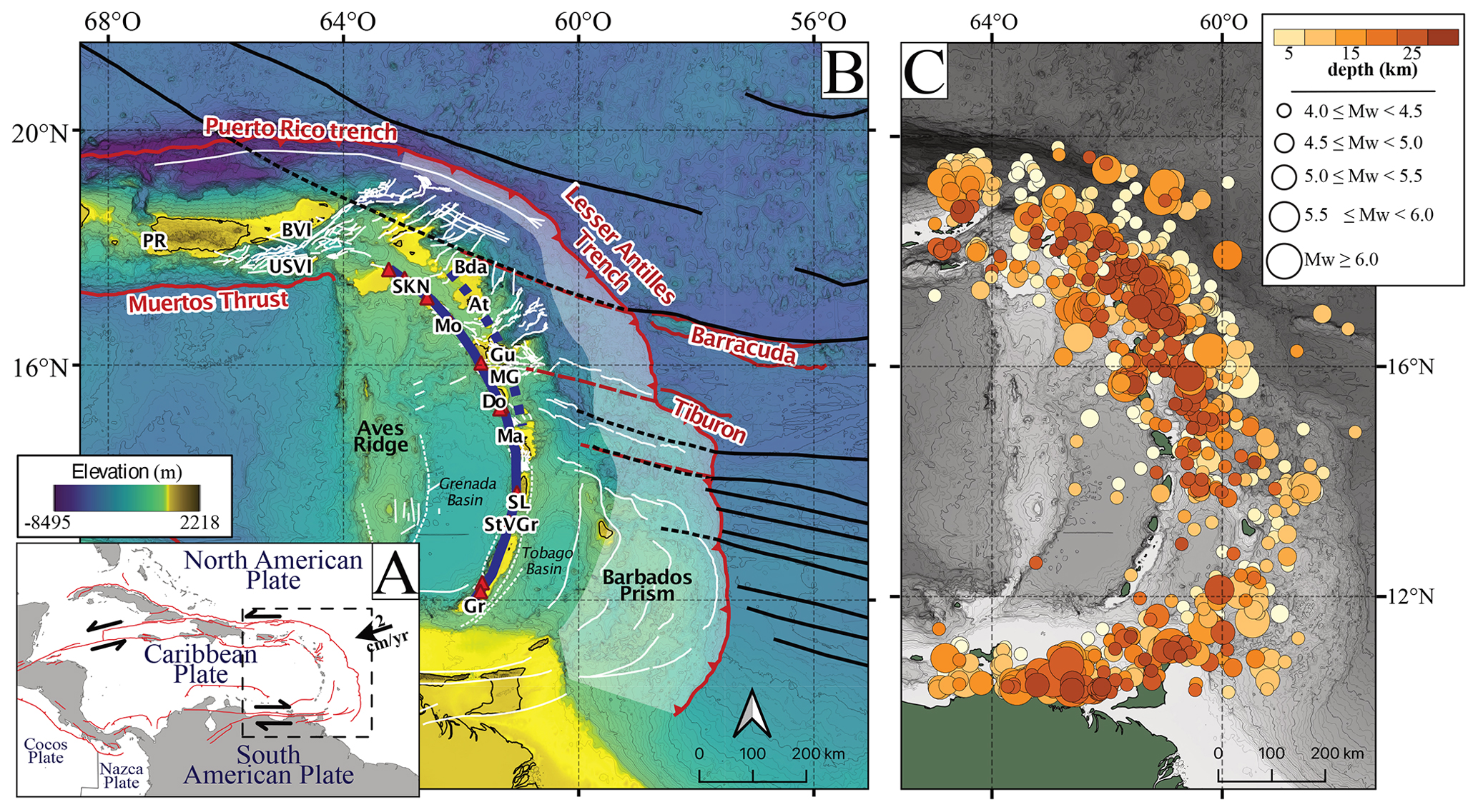
Figure 1Seismotectonic framework of the Lesser Antilles. (a) Regional tectonics. Black arrows: plate motions; red lines: main faults from the Global Earthquake Model; dashed square: map extent in (b). (b) Lesser Antilles structural features. White area: accretionary prism; red triangles: active volcanoes; thick solid and dashed blue lines: active and inactive volcanic arc; black lines: fracture zones; dashed black lines: subducted fracture zone extensions; white lines: known crustal faults; red lines: aseismic ridges; dashed red lines: subducted aseismic ridge extensions; PR: Puerto Rico; BVI: British Virgin Islands; USVI: United States Virgin Islands; Bda: Barbuda; SKN: Saint Kitts and Nevis; At: Antigua; Mo: Montserrat; Gu: Guadeloupe; MG: Marie-Galante; Do: Dominica; Ma: Martinique; SL: Saint Lucia; StVG: Saint Vincent and the Grenadines; Gr: Grenada. Fracture zones are extracted from Global Seafloor Fabric (https://www.soest.hawaii.edu/soestwp/, last access: 10 June 2021) and bathymetry from Global Multi-Resolution Topography (https://www.gmrt.org/, last access: 17 May 2021). (c) Instrumental seismicity 1906–2021 of the upper-plate crust from ISCU-cat (M≥4).
The upper-plate tectonics are marked by a strong N–S asymmetry. South of ∼ 15° of latitude, the upper plate is characterized by the large Barbados accretionary wedge (e.g., Speed and Larue, 1982; Gomez et al., 2018; Deville, 2023), the Tobago forearc basin, and a single volcanic arc with few major active faults and structures (Fig. 1b). In contrast, the northern region is associated with a thin sedimentary wedge and long-term subduction erosion. The forearc basins are affected by trench-perpendicular normal faults, and the active volcanic arc (coupled with an old inactive arc in the forearc position) is affected by trench-parallel normal and strike-slip faults (Boucard et al., 2021; Feuillet et al., 2002, 2011b). The N–S asymmetry is also present in the arc crustal thickness, increasing from 20–25 km in the south to reach ∼ 35 km in the north beneath St Kitts (Schlaphorst et al., 2021). Across the arc, geodetic velocities indicate very small motions relative to the Caribbean Plate and < 1 mm yr−1 of N–S intra-arc extension (Symithe et al., 2015; van Rijsingen et al., 2021), generally consistent with earthquake focal mechanisms and forearc basin structures (Allen et al., 2019; Lindner et al., 2023).
The overall N–S asymmetry of the Lesser Antilles subduction system also appears in the instrumental seismicity, with higher activity north of ∼ 15° of latitude compared to the southern region (McCann et al., 1984; Hayes et al., 2014; Fig. 1c). However, this pattern does not appear in the historical catalog (Lambert, 2009; Bertil et al., 2023; Lambert and Samarcq, 2024; Fig. 2a). This discrepancy highlights the difficulty and limits of the seismicity catalogs. Recent damaging earthquakes are associated with magnitudes M = 7–7.5 (e.g., 1953 Mw=7.3 south of Martinique, 1969 Mw=7.2 near Barbados, 1974 Mw=7.5 between Barbuda and Antigua, 2007 Mw=7.4 north of Martinique; Fig. 2c). All are attributed to normal faulting either within the subducting plate (1953, 1969, and 2007; Russo et al., 1992; Dorel, 1981; Régnier et al., 2013) or within the upper plate or mantle wedge (1974; McCann et al., 1982; Feuillet et al., 2002, 2011b). One of the outstanding characteristics of the Lesser Antilles subduction is the lack of instrumental large (M>6.5) thrust earthquakes associated with the subduction interface.
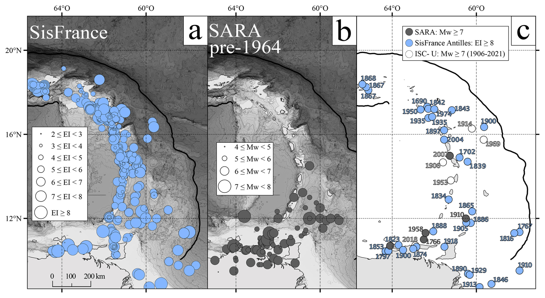
Figure 2Lesser Antilles historical seismicity and major earthquakes. Thick solid black line: Lesser Antilles, Puerto Rico, and Muertos troughs. (a) SisFrance historical seismicity. (b) SARA pre-1964 historical seismicity. (c) Major instrumental and historical earthquakes from the ISCU-cat, SARA, and SisFrance catalogs.
In seismic hazard analysis, seismotectonic zoning models are designed to fill knowledge gaps, and the Lesser Antilles arc and its active seismicity are poorly known. Area sources are built by crossing both qualitative and quantitative criteria with subjective interpretation. When knowledge is sufficient (data collected homogeneously over space and time), the zoning can be purely based on quantitative criteria. In this study, the most recent data have been collected and integrated. The seismotectonic zoning model comprises area sources and fault sources, with the former defining domains of uniform tectonic and seismicity characteristics. Area source boundaries are constructed following three principles, considering existing knowledge and uncertainties: (1) boundaries are defined in priority by (a) the seismicity distribution, (b) faults and local tectonics, (c) geodetic data, and (d) local geology. (2) A single large zone is preferred to several small zones, unless data clearly show different tectonic and seismicity characteristics that require zone divisions. (3) Area sources are chosen to prevent seismicity dilution within zones that are too large. Seismicity distribution, deformation style extracted from focal mechanisms, crustal fault locations, and tectonic features were superimposed using a geographic information system (GIS) tool as illustrated in Figs. 4, 7, 9, and 10. Boundaries depict a consensus between seismotectonic data and discussions with Lesser Antilles experts (Lesser Antilles Working Group). To address geological and tectonic complexities and specificities of the region, we have opted for a division into several zones instead of a simple north–south division. Specific detailed subdivisions are limited to cases where they are supported by the available data. This methodology better constrains each source and allows us to manage uncertainties more precisely by limiting the propagation of errors to the whole region.
The primary seismicity catalog is a homogenized Mw instrumental catalog (hereafter ISCU-cat) composed of seismicity extracted from the International Seismological Centre (ISC, 2023) catalog and regional catalogs from 1906 to 2021 (Bertil et al., 2022, 2023; Bertil, 2024). The Mw homogenization was done using reference magnitudes given by the Global Centroid Moment Tensor (GCMT; Dziewonski et al., 1981; Ekström et al., 2012) project and the National Earthquake Information Center (NEIC; Guy et al., 2015). This catalog is considered complete since 1964 for Mw≥4.3, and completeness for Mw≥4 is not reached until 1985 (Bertil et al., 2022, 2023; Bertil, 2024). Taking Mw≥4.0 for the whole catalog limits bias in regional completeness, even if few data exist before 1985 (6 %). No hypocenter relocations were conducted, but a first-order quality score is supplied based on the phase number (pn) from A (pn ≥ 1000) to E (pn ≤ 3) instead of location uncertainties. ISCU-cat comprises 0.2 % A, 5.3 % B, 18.6 % C, 75.7 % D, and 0.2 % E. The ISCU-cat spatial variations in seismicity are analyzed to determine area source boundaries and their associated Gutenberg–Richter distributions. The ISCU-cat needs for magnitude estimation improvements are discussed in Sect. 5.
ISCU-cat is completed for local analysis around Guadeloupe and Martinique with the instrumental catalogs IPGP (Institut de physique du globe de Paris; Saurel et al., 2022) and CDSA (seismological data center for the French Lesser Antilles; Massin et al., 2021) and regionally by the historical catalogs SisFrance Antilles (Vermeersch et al., 2002; Lambert, 2009; Bertil et al., 2022; Lambert and Samarcq, 2024) and SARA (South American Risk Assessment; Gómez-Capera et al., 2017) (Fig. 2a, b). SisFrance comprises 19 % of quality B (corresponding to ∼ 10 km location uncertainty) and 81 % of quality C (10–20 km uncertainty). For the SARA pre-1964 catalog, no uncertainties or quality is available. Historical seismicity allows us to discuss past activity of specific regions and to compare it with instrumental seismicity and geodetic data (Foix et al., 2023a). The exact location of some historical events is still debated, such as the 1839 and 1843 earthquakes. Bernard and Lambert (1988) and McCann et al. (1984) interpreted them as megathrust earthquakes, whereas van Rijsingen et al. (2021) proposed that the 1843 event had a smaller magnitude or different mechanism or location within the subducted slab and that the 1839 event could also be located in the subducted slab.
We construct a composite catalog of earthquake focal mechanisms comprising 572 events from the GCMT (Dziewonski et al., 1981; Ekström et al., 2012) and ISC (Lentas, 2018; Lentas et al., 2019) as well as Corbeau et al. (2019, 2021), González et al. (2017), and Ruiz et al. (2013), from 1977 to 2021, hereafter named FMAnt2021 (Focal Mechanisms Antilles 2021). From FMAnt2021, we compute average faulting types and P- and T-axis orientations on a regular grid using the Mazzotti et al. (2021) method (smoothing distance of 40 km, minimum of three mechanisms within a radius of 50 km). FMAnt2021 allows us to determine area source boundaries and deformation types.
The oceanic subducted plate surface is based on a unification of the slab models (hereafter Bie-Lau Slab) of Bie et al. (2019) and Laurencin et al. (2018) (Figs. 3b and S2 in the Supplement). We have georeferenced and digitized these interface geometries to combine them into one unique surface using a GIS tool every 10 km of depth. We then transformed it into a grid that can be extrapolated to get a surface and be used for earthquake sorting. Paulatto et al. (2017) slab and Moho geometries were not used in order to keep consistency along the arc. The slab top geometry may vary not only according to the publications, but also according to the interpretation of the presence or absence of a slab. Beneath the Lesser Antilles central area, at depths of around 170–200 km, Lindner et al. (2023) observed a seismic gap in the lithosphere of subducted American plates, whereas Braszus et al. (2021) observed a continuous slab, in agreement with the tomography of Bie et al. (2019). These differences would have an impact on earthquake sorting and the resulting statistics.
No unified database of crustal faults exists for the Lesser Antilles, and knowledge is heterogeneous along the arc. We use crustal faults from the Global Earthquake Model of the Caribbean region (Styron et al., 2020) completed with local studies of Boucard et al. (2021), Feuillet et al. (2001, 2002, 2004, 2011a, 2011b), Garrocq et al. (2021), Laurencin et al. (2017, 2019), and Leclerc et al. (2016) (Fig. 1b). Various unknowns and interpretations remain on fault activities. The Anegada Passage fault system (Fig. 3a, label 5) motion was interpreted from extensional faulting to sinistral or dextral transtension (Laurencin et al., 2017, and references therein). Fault activity is sometimes debated, such as for the V-shaped basin faults from Guadeloupe to Saint Kitts and Nevis (Feuillet et al., 2001, 2011a; Boucard et al., 2021). Moreover, structures still need to be imaged and understood south of Saint Lucia. Finally, we use the geodetic velocities from van Rijsingen et al. (2021) to calculate geodetic strain rates (Fig. 4) and, complemented by micro-atoll subsidence data (Philibosian et al., 2022), to test models of megathrust interseismic coupling on 2D cross-sections. We also use the geodetic velocities to calculate extension rate for some specific regions and determine an associated standard uncertainty (, where σ is standard deviation and N denotes measurements).
Details of the area source limits and geometries are given in the Supplement (Figs. S1 and S2 and Table S1) and in a risk prevention department report (Foix et al., 2023a), with information on the Gutenberg–Richter distribution for each area source (Table S1 in the Supplement). The Supplement for this article also includes the minimum magnitude sensitivity analysis impact for the Marie-Galante graben (Fig. S4 in the Supplement) and a comparison between Martin and Combes (2001) and this study (Fig. S5 in the Supplement).
4.1 Upper-plate seismotectonics, area sources, and faults
4.1.1 Upper-plate seismotectonics
At its northern end, the Lesser Antilles subduction is limited by the Anegada Passage (Fig. 3a), an E–W en échelon strike-slip system (Laurencin et al., 2017) with low relative motion based on geodetic data (Symithe et al., 2015) that terminates eastward in the pull-apart Sombrero Basin (Laurencin et al., 2019). The Bunce–Bowin sinistral strike-slip fault system marks the limit between the thin accretionary wedge and the upper-plate backstop (Fig. 3a). Its maximum slip rate is ∼ 16 mm yr−1 (Laurencin et al., 2019), with no known large earthquake on this fault. Its small depth extent (∼ 5 km) suggests that only moderate earthquakes can be expected (ten Brink and Lin, 2004).
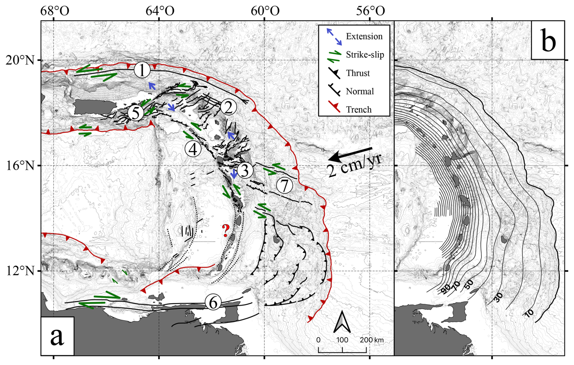
Figure 3Crustal faults and slab geometry. (a) Crustal faults (solid black lines) and relative motions (blue and green arrows) (see Sect. 4.1). Red question mark: lack of knowledge on possible normal faults along the arc. (1) Bunce Fault, (2) Tintamarre Fault crosscutting a V-shaped basin, (3) Marie-Galante graben, (4) Bouillante–Montserrat Fault, (5) Anegada Passage fault system, (6) El Pilar fault system, (7) lateral ramp. (b) Bie-Lau Slab unified slab top geometry (see Fig. S2 in the Supplement).
The northern half of the Lesser Antilles arc, from Antigua to Guadeloupe, is characterized by Paleogene V-shaped basins (Fig. 3a), inferred to be related to the collision of the Caribbean Plate with the Bahamas Bank and partly overlapped by normal faults (e.g., Tintamarre Fault, Fig. 3a) attributed to Mid-Miocene margin erosion (Boucard et al., 2021). The V-shaped structures are interpreted to be inactive in the north (Symithe et al., 2015; Boucard et al., 2021) and active east of Guadeloupe (Feuillet et al., 2001). Present-day tectonics are characterized by trench-perpendicular normal-fault bounding grabens and spurs in the forearc region, such as the Marie-Galante graben (Fig. 3a) or the Bertrand–Falmouth spur, associated with N–S to NNW–SSE extension (Feuillet et al., 2001, 2002). Along the active volcanic arc, trench-parallel en échelon faults accommodate sinistral motion, such as the Bouillante–Montserrat fault system (Fig. 3a), or normal motion, such as the Roseau Fault (Feuillet et al., 2001, 2011a; Leclerc and Feuillet, 2019). Shallow seismicity attests to the normal and strike-slip faulting on these trench-parallel and trench-perpendicular structures (Lindner et al., 2023), e.g., the 2004 Mw=6.3 Les Saintes earthquake on the Roseau Fault (Bazin et al., 2010; Feuillet et al., 2011b; Escartín et al., 2016; Fig. 2c). These recent fault systems are inferred to be related to strain partitioning of the oblique plate convergence (Feuillet et al., 2001, 2011a).
The transition in the southern Lesser Antilles region is marked by lateral ramps following the Barracuda Ridge and Tiburon Rise (Brown and Westbrook, 1987; Fig. 3a). South of Saint Lucia, fault system knowledge is sparse, and a possible extension of the northern trench-parallel en échelon normal faults remains unknown. Large normal faults have been interpreted along both sides of the volcanic arc from south of Martinique to Grenada (Christeson et al., 2008; Aitken et al., 2011; Fig. 3a, question mark). However, recent seismic reflection data show no clear evidence of such large faults (Garrocq et al., 2021). They only indicate normal faults along the west flank of the arc, between Saint Vincent and the Grenadines and Saint Lucia, possibly similar to those north of Martinique.
4.1.2 Upper-plate area sources
The primary area source division is trench-parallel to take into account the differences in structure, tectonics, and seismicity between the accretionary wedge (AW), forearc (FA), arc (A), and backarc (BA) regions of the upper plate (Fig. 4a). In the upper-plate area sources, we also include seismicity in the outer rise of the downgoing plate (DP). The secondary division is trench-perpendicular based on structures, fault types, and seismic activity in the different regions. The bottom limits of these area sources are based on the seismicity characteristics in each zone or on the structural limits. We fix the bottom limit of the crustal upper-plate area sources either at the Moho (set at 28 km; Kopp et al., 2011; Bie et al., 2019) or at the downgoing-plate surface depth (minus 5 km to avoid interface seismicity). The diffuse distribution of the crustal seismicity, due to the network geometry, does not allow a more specific definition. An alternative to the crustal source areas is to set their bottom limit at an assumed seismogenic depth of 15–20 km, similar to that observed for active faults. The bottom limit of crustal downgoing-plate area sources is fixed at 10–15 km depth. Due to low-seismicity records and the long distances of these sources to the islands, the choice of this depth has no impact on hazard calculations. In the following, we highlight the main points of interest and sources of uncertainties.
DP (downgoing-plate) sources. The seismotectonics of these zones are poorly constrained, with very limited seismicity and only two moderate instrumental events (2003 M = 6.6 and 2016 M = 5.6). Large potentially seismogenic structures are observed down to 10–15 km depth on the oceanic-plate outer rise (Marcaillou et al., 2021; Allen et al., 2022), which could generate large normal or strike-slip earthquakes. Based on global analogs, outer-rise seismicity may reach magnitudes of M∼8–8.5 (e.g., Sumatra, Japan; Meng et al., 2012; Kanamori, 1971).
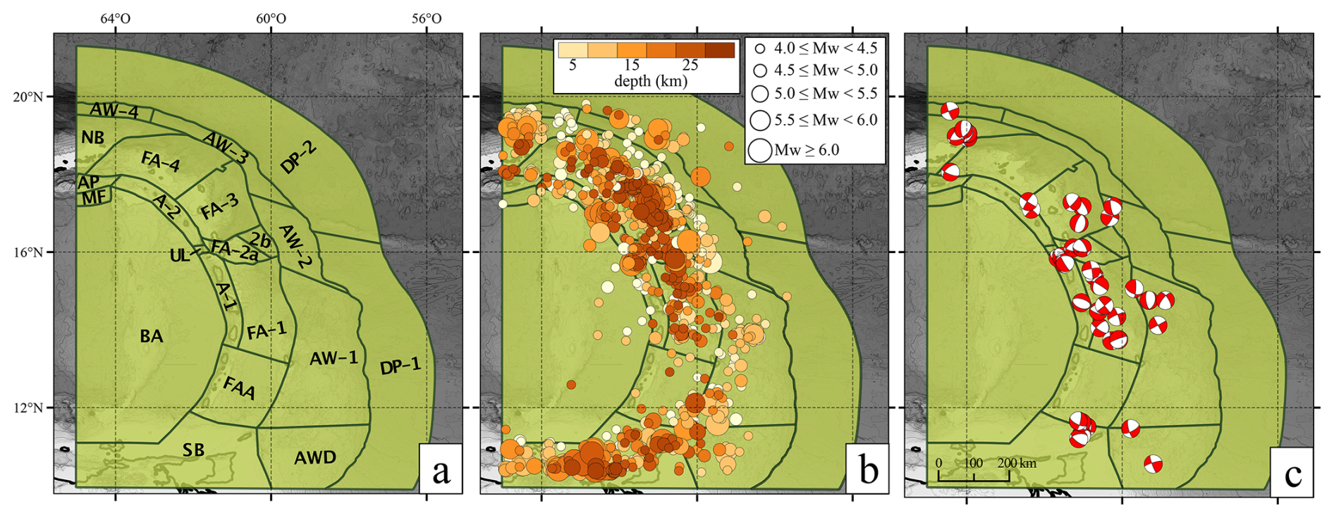
Figure 4Lesser Antilles upper-plate crust seismotectonic zoning model. (a) Crustal area sources. SB: southern boundary; AW: accretionary wedge; AWD: AW death; FA: forearc; A: arc; FAA: FA and A together; BA: backarc; MF: Muertos Fault; NB: northern boundary; AP: Anegada Passage; UL: undefined limit; DP: downgoing plate. (b) Crustal seismicity from ISCU-cat (M≥4) based on Bertil (2024). (c) Crustal focal mechanisms from FMAnt2021.
AW (accretionary wedge) sources. These zones are divided along the strike to account for the evolution from the large Barbados prism in the south (AW-1) to the narrow prism under erosion in the north (AW-3 and AW-4). The transition (AW-2) is defined by the Tiburon Rise and Barracuda Ridge extensions beneath the wedge (Fig. 1b). The southern end corresponds to a zone of progressive termination (AW death, AWD), where the accretionary wedge gives way to more compacted material. This boundary is not clearly defined. The seismogenic potential of these sources is poorly constrained due to the low precision of earthquake locations. A few moderate events may be associated with these zones without certainty (e.g., 1922 M=6.1, Russo et al., 1992; 2015 M=5.7 clusters, 1767 and 1816 historic earthquakes, Fig. 2c and Le Roy et al., 2017). Ocean-bottom seismometer (OBS) recordings show no seismicity over a 6-month period in the wedge off Guadeloupe (Laigle et al., 2007, 2013b; Ruiz et al., 2013). Worldwide, accretionary prisms are associated with high fluid content, unconsolidated sediment, and low-frequency earthquakes or tremors (Ito and Obara, 2006; Obana and Kodaira, 2009). They are not associated with really well known earthquakes, but very few standard events occurred (e.g., 2023 M = 5.5, Panama; Bradley and Hubbard, 2023).
Forearc (FA) and arc (A) sources. South of Saint Lucia, the forearc and arc are grouped in a common area source (FAA) due to the low level of instrumental seismicity and lack of an identified major fault. The northern limit corresponds to a smooth northward increase in seismicity. The geodetic velocity increase between Saint Lucia and Saint Vincent and the Grenadines is equal to 0.6 ± 0.3 mm yr−1 and 1.4 ± 0.4 mm yr−1 toward the south, for the eastern and northern components, in the Caribbean Plate reference frame (Fig. 5). This is not associated with focal mechanisms marking extension (Fig. 4c). The central and northern regions are characterized by a distinction between arc (A) zones, associated with arc-parallel normal and strike-slip faults, and forearc (FA) zones, associated with NW–SE en échelon faults (Figs. 1b, 3a). The lateral divisions correspond to changes in instrumental seismicity rates or to independent seismotectonic features such as the Marie-Galante graben (FA-2). The westward extension of the Marie-Galante graben is uncertain, with two alternative sources (FA-2a or FA-2b). Similarly, the transition between A1 (normal faulting) and A2 (normal to sinistral faulting) is uncertain and associated with the alternative limits (undefined limits, ULs). The seismogenic potential of the forearc and arc is characterized by seismicity clusters with a more sustained activity north of Saint Lucia (Fig. 4b). Large events associated with arc tectonics are the 2004 Mw=6.3 Les Saintes and the 1867 Mw=7.2 Virgin Islands earthquakes, whereas the 1967 Mw=6.4 earthquake struck the forearc (Fig. 2c). Larger historical events may have occurred in the arc and forearc (1690 Mw=7–8 near Barbuda, 1839 (M = 7.5–8) and 1843 (M = 8–8.5) offshore Martinique and Guadeloupe, 1867 MS=7.2 near the Virgin Islands), but their exact locations and associated structures are unknown. The 1843 moderate tsunami intensity (Lambert and Terrier, 2011) and the possible 1839 sea disturbance (Clouard et al., 2017) favor intraslab or deep interface locations for these two earthquakes.
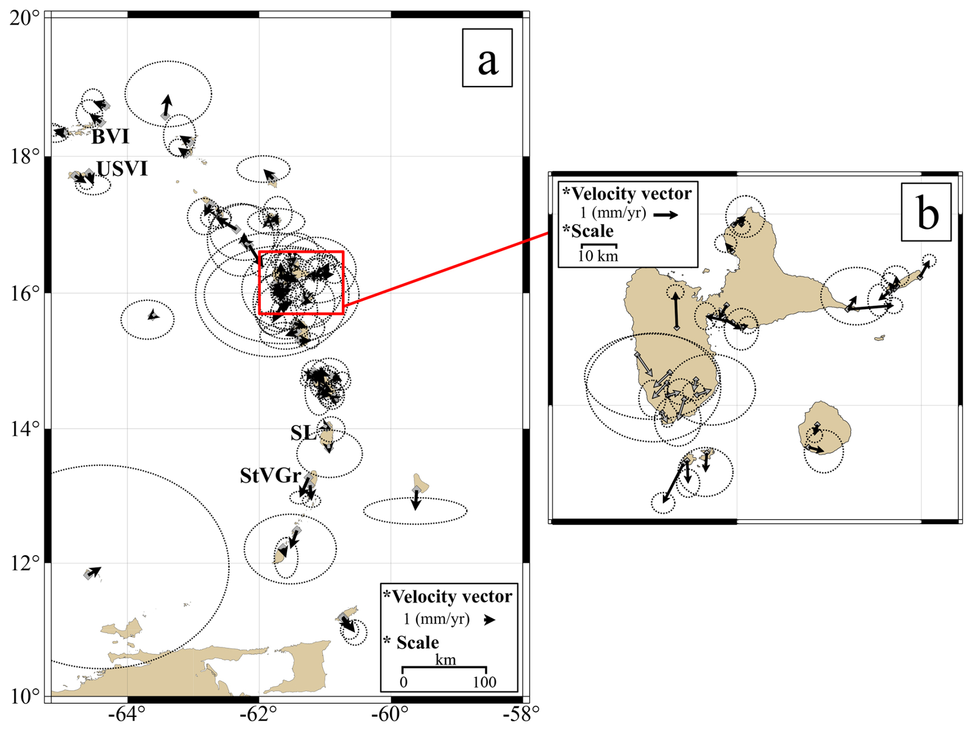
Figure 5Geodetic velocities of the Lesser Antilles arc in the Caribbean Plate reference frame based on van Rijsingen et al. (2021). Black arrows: velocity vectors; dashed black circles: error ellipses with 95 % confidence. (a) Lesser Antilles arc. (b) Zoomed-in view of Guadeloupe. Grey arrows: velocity vectors related to La Soufrière volcano.
Boundary zones are defined at the northern boundary (NB), southern boundary (SB), and western backarc (BA) limits of the model to capture diffuse seismicity without specific information. Two smaller zones are defined along the southern Anegada Passage (AP) and the Muertos Fault (MF). The AP zone is associated with few M≥4 instrumental earthquakes (Fig. 4b), the historical 1867 Mw=7.2 Virgin Island earthquake (Fig. 2c), and a geodetic velocity gradient of 1.8 ± 0.4 mm yr−1 and −0.55 ± 0.2 mm yr−1 for the eastern and northern components (Fig. 5), highlighting the uncertainty in local active tectonics.
4.1.3 Upper-plate fault sources
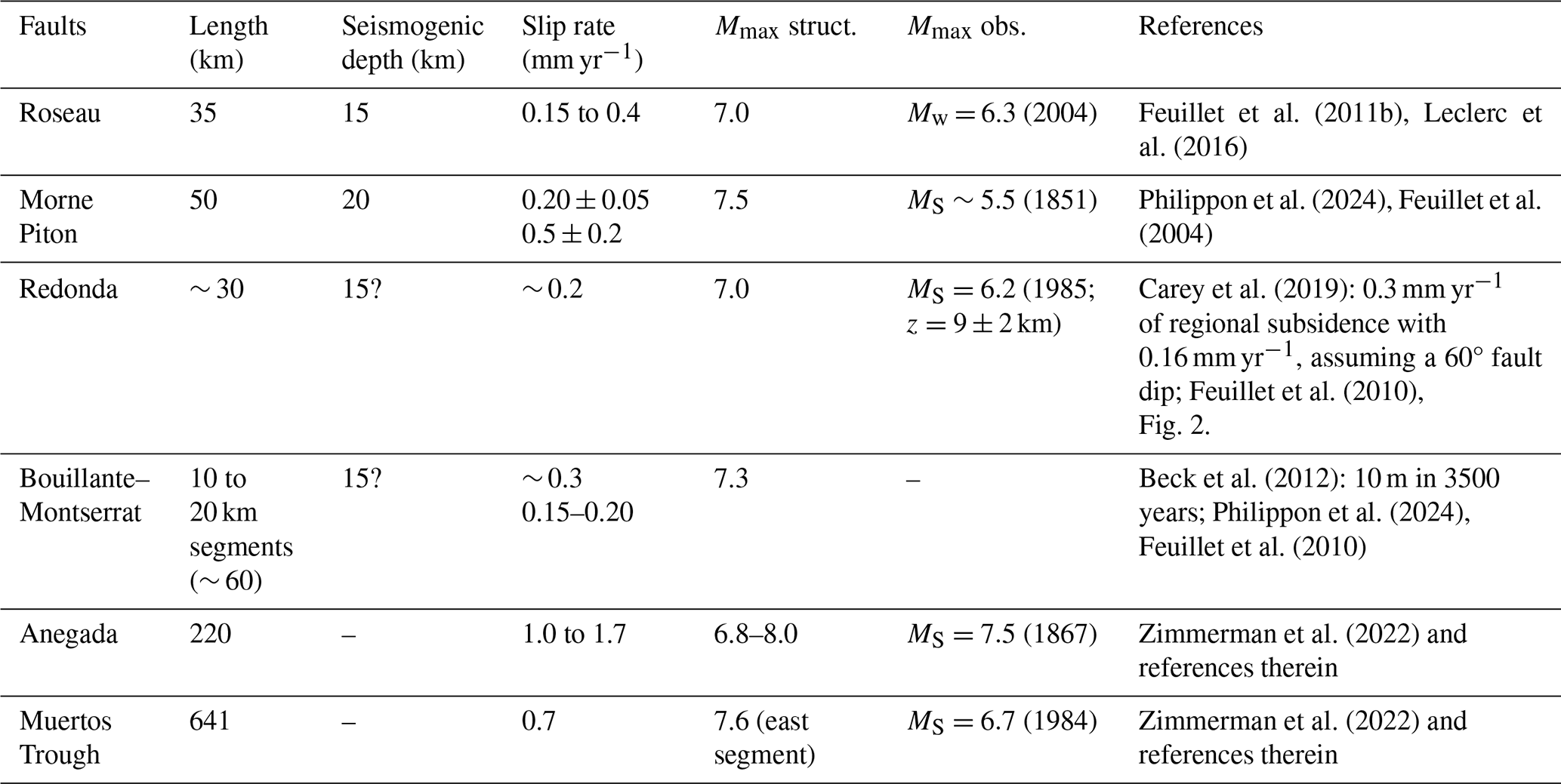
Fault geometries and slip rates are required to integrate fault sources in seismic hazard models. Only a few Lesser Antilles faults meet these criteria: the Roseau, Morne Piton, and Bouillante–Montserrat faults near Guadeloupe; the Redonda Fault between Saint Kitts and Nevis and Montserrat, and the Anegada Passage and Muertos Trough at the northern end (Fig. 6a). Slip rates and maximum structural magnitudes based on the Wells and Coppersmith (1994) scaling law are given in Table 1. Additional faults and structures have been studied on land and offshore, such as the May Fault (Sedan and Terrier, 2001) or the North Lamentin and Schoelcher faults (Terrier, 1996), but the available data are not considered robust enough to be included in a seismic hazard model at this time.
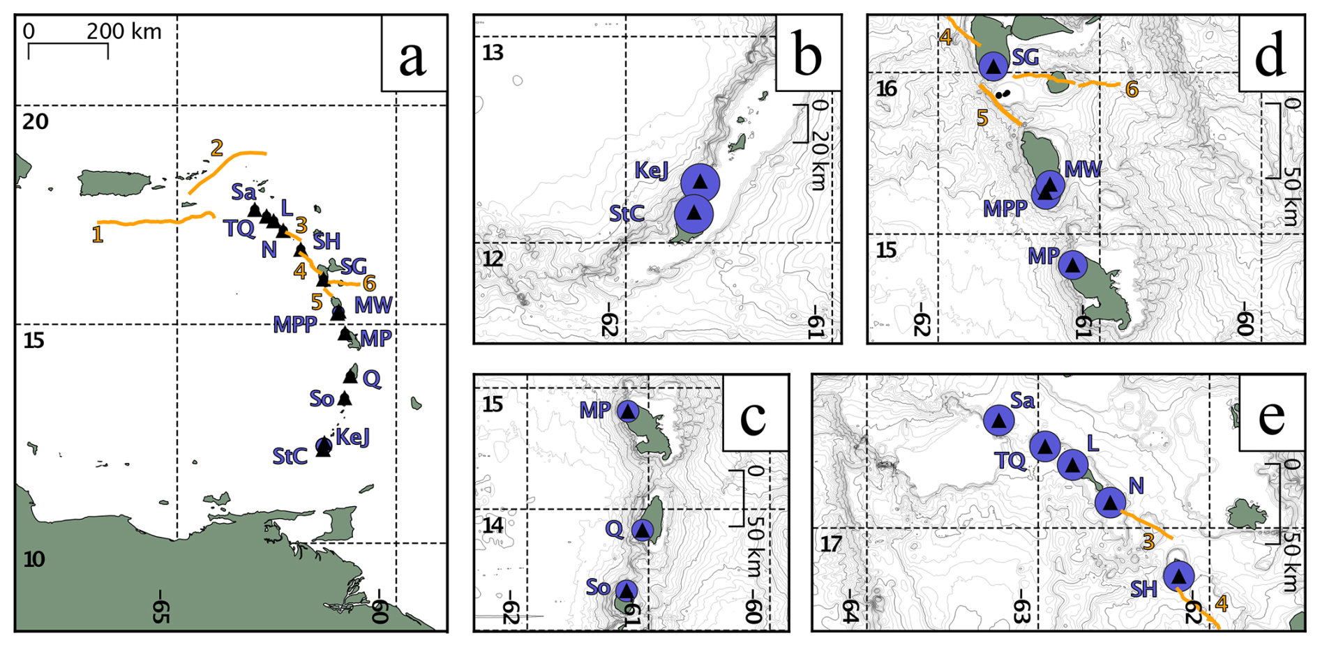
Figure 6Lesser Antilles volcanic (purple circles) and fault (solid orange lines) seismogenic sources. (a) Geographical repartition of active volcanoes and source faults. Black triangles: active volcanoes; StC: Saint Catherine; KeJ: Kick'em Jenny; So: La Soufrière of Saint Vincent; Q: Qualibou; MP: Mount Pelée; MPP: Morne Plat Pays; MW: Morne Watt; SG: La Soufrière of Guadeloupe; SH: Soufrière Hills; N: Nevis; L: Liamuiga; TQ: The Quill; Sa: Saba; 1: Muertos Trough; 2: Anegada Passage fault system; 3: Redonda Fault, 4: Bouillante–Montserrat faults; 5: Roseau Fault; 6: Morne Piton Fault. (b–e) Zoomed-in view of volcanic area sources, corresponding to a 10 km radius around the volcanic edifices.
Table 1Seismogenic fault source characteristics of the fault's seismogenic source.
4.1.4 Marie-Galante graben
The Marie-Galante graben corresponds to the FA-2a seismotectonic zone (Fig. 4a). Guadeloupe is defined as a key transition area between the northern and southern Lesser Antilles arc in terms of geodetic velocities, seismicity rates, fault orientations, and tectonic style. Arc-parallel (Roseau, Bouillante–Montserrat) and arc-perpendicular (Marie-Galante graben) faults intersect near La Soufrière volcano. The northern part of Guadeloupe is marked by northward GNSS velocities, while the southern part is characterized by southward velocities (Fig. 5). The graben may have generated three historical earthquakes in the last 150 years, with intensities from VII to VIII, including the destructive 29 April 1897 M=5.5–6 earthquake located close to Pointe-à-Pitre (Fig. 2c) and linked with the Gosier Fault (Bernard and Lambert, 1988). The Morne Piton Fault (Fig. 6a, number 6) may be responsible for the 1851 earthquake (intensity VII; Feuillet et al., 2011b). The structural characteristics of the Morne Piton Fault are compatible with potential M=6.5 earthquakes every 1400 to 3300 years or M=5.5 every 400 to 1000 years (Feuillet et al., 2004). The Morne Piton Fault slip rate is estimated to be between 0.2 ± 0.05 mm yr−1 and 0.5 ± 0.2 mm yr−1 (Philippon et al., 2024; Feuillet et al., 2004).
We estimate the overall graben extension rate from ISCU-cat and geodetic data. From the difference in geodetic velocities between northern and southern Guadeloupe, the extension rate is ∼ 1.1 ± 0.2 mm yr−1 for the northern component. A formal strain rate inversion of these velocities yields an extension rate of ∼ 0.6 mm yr−1 integrated over a distance of 28 km. For the seismicity data (ISCU-cat), we use the 743 events in FA-2a to estimate a Gutenberg–Richter magnitude–frequency distribution and its associated seismic moment and deformation rate (Fig. S3 in the Supplement; Mazzotti and Adams, 2005). Using minimum and maximum magnitudes of 3.0 and 7.3 (based on fault geometry), a seismogenic thickness between 15 and 20 km, and a normal-fault geometry (length = 135 km, width = 75 km, dip = 60°, and rake = 90°), we estimate an extension rate from 0.5 to 1 mm yr−1 (with a b value of 1.2–1.5, Fig. S4 in the Supplement). These estimated graben extension rates of 0.5–1.1 mm yr−1 are compatible with the Morne Piton Fault slip rate (0.2–0.5 mm yr−1). The slip rates of other graben faults have not been estimated yet and may accommodate a part of the deformation.
4.2 Subduction interface seismotectonics and area sources
4.2.1 Subduction interface seismotectonics
The seismogenic potential of the Lesser Antilles megathrust is a major conundrum. No large megathrust earthquake has been recorded in the instrumental period, while the historical 1839 (M=7.5–8) and 1843 (M=8–8.5) earthquakes may be associated with the interface, the subducted slab, or the upper plate, with higher probabilities of a deep interface or intraslab (Bernard and Lambert, 1988; Feuillet et al., 2011a; Hough, 2013). North of Guadeloupe, the interface seismicity is highlighted by moderate M=4.5–6.5 reverse-fault earthquakes down to 60–65 km depth (Lindner et al., 2023), whereas very few similar events occur to the south (Fig. 7b, c). In contrast, no interface earthquakes were recorded below 20 km depth during a 6-month OBS deployment offshore Guadeloupe and Martinique (Laigle et al., 2013a). The 60–65 km downdip extent is consistent with thermal modeling of the subduction system, which shows that the seismic–aseismic transition at ∼ 350 °C occurs ∼ 65 km below Martinique and Saint Martin (Ezenwaka et al., 2022), with along-strike variations compatible with the interface seismicity distribution (Gutscher et al., 2013).
Geodetic data indicate that the present-day interseismic coupling of the whole megathrust is very low (∼ 10 %) (Symithe et al., 2015; van Rijsingen et al., 2021). Coral and micro-atoll subsidence rates are interpreted as being indicative of strong interseismic coupling on the megathrust at ∼ 40–80 km depths between Martinique and Barbuda (Weil-Accardo et al., 2016; Philibosian et al., 2022). Subsidence from geodetic vertical motions, coherent with coral and micro-atoll data, was observed by was observed by van Rijsingen et al. (2022), and they modeled that a locked or partially locked interface would produce uplift. In order to test the compatibility of Philibosian et al. (2022) and van Rijsingen et al. (2021) results, we performed a first-order simulation of the megathrust interface interseismic coupling depth along a 2D cross-section (Fig. 8). We did not consider the 3D slab geometry. We simulated the coupling depth proposed by Philibosian et al. (2022) independently of our proposed area sources. Results from van Rijsingen et al. (2021, 2022) as well as simple 2D cross-section models (Fig. 8) show that the shallow 0–40 km depth section of the megathrust must be associated with very low coupling to be compatible with horizontal geodetic velocities. Vertical velocities indicate a general subsidence rate that could, in part, be associated with strong, deep (40–70 km) interseismic coupling, although details of this conclusion are debated (Philibosian et al., 2022; van Rijsingen et al., 2022).
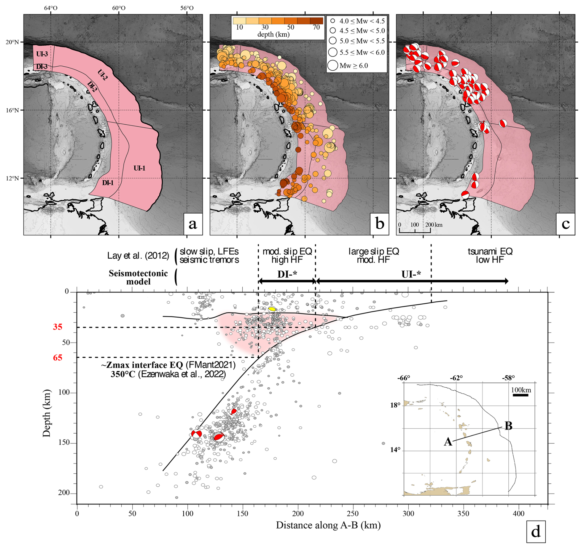
Figure 7Lesser Antilles interface seismotectonic zoning model. (a) Interface area sources. UI-*: upper interface; DI-*: deep interface. (b, c) The same as Fig. 4b, c but for the interface seismicity. (d) Interface conceptual model based on Lay et al. (2012) and adapted for the Lesser Antilles; the AB cross-section, reported in the inset with a corresponding domain (mod.: moderate; HF: high frequency; LFEs: low-frequency events; EQ: earthquake); seismicity from ISCU-cat (white dots) and CDSA (grey dots) along AB; thick solid black lines: slab and Moho from Paulatto et al. (2017); focal mechanisms from FMAnt2021; thin dashed black lines: domain depth limits; the UI-* bottom limit is marked at 35 km depth and the DI-* bottom limit at 65 km depth; pink zone: mantle wedge seismicity.
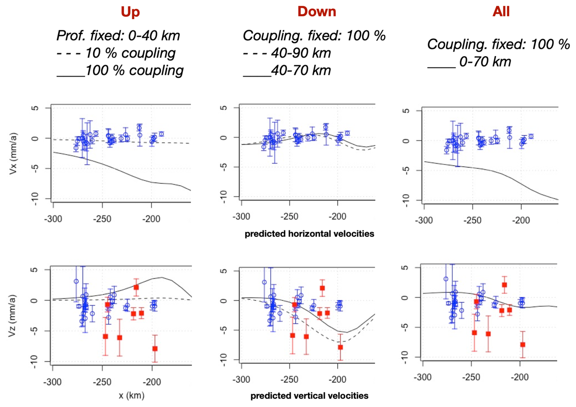
Figure 8Lesser Antilles vertical (Vz) and horizontal (Vx, in the profile direction) velocities from GNSS (blue squares) and micro-atoll (red squares) data compared to predictions from 2D models of subduction interface interseismic coupling for a cross-section at the latitude of Guadeloupe. Three cases are considered: interseismic coupling of the upper part of the interface (“Up”, 0–40 km depth), interseismic coupling of the deep part (“Down”, 40–90 km depth), and interseismic coupling of the entire interface (“All”). Micro-atoll and GNSS data are from Philibosian et al. (2022) and van Rijsingen et al. (2021).
4.2.2 Subduction interface area sources
In order to account for this conflicting information, we propose a seismotectonic zoning model of the Lesser Antilles megathrust based on the reference model of Lay et al. (2012), which divides the subduction interface into four downdip domains based on seismic behavior and high-frequency (HF) radiation: 0–15 km depth – tsunami earthquakes and low HF; 15–35 km depth – great earthquakes and moderate HF; 35–55 km depth – large earthquakes and strong HF; > 55 km depth – stable-slip, slow-slip events, and very-low-frequency earthquakes. A previous division of the subduction interface for tsunami hazard was proposed based on plane dipping (IOC-UNESCO, 2020). Our simplified version of this model adapted to seismic hazard assessment for the Lesser Antilles corresponds to the following (Fig. 7a, d):
-
There is an upper interface (UI) from 0 to 35 km depth capable of generating great M=8–9 megathrust earthquakes but associated with very low interseismic coupling. Assuming an average slip per event of 5–10 m, an interseismic coupling of 10 %, and a convergence rate of 20 mm yr−1, the great-earthquake return period is ∼ 2500–5000 years, compatible with sedimentary records (Seibert et al., 2024).
-
There is a deep interface (DI) from 35 to 65 km depth that can generate large M=7–8 earthquakes and is associated with either low interseismic coupling (model 1, compatible with geodetic data) or high interseismic coupling (model 2, compatible with coral data). We propose a lower weight on applied to model 2 because of the high variability and large uncertainties in the coral data.
The depth limits between UI and DI are assumed to be constant. An along-strike division between the area sources UI-1–DI-1 and UI-2–DI-2 is set near the Barracuda Ridge and Tiburon Rise depth extensions (Figs. 1b, 7a) to reflect the North American–South American plate boundary and the N–S differences in oceanic-plate fracturing, megathrust seismicity, and convergence direction. The issue of lateral earthquake propagation across this lateral limit is unresolved. In addition, the minor area sources UI-3 and DI-3 define the eastern end of the Puerto Rico subduction zone.
4.3 Subducted slab seismotectonics and area sources
Seismotectonics of the subducted oceanic plate is characterized by high seismic activity down to ∼ 150–200 km depth (Fig. 9b), associated with downdip extension, normal faulting, and strike-slip faulting (González et al., 2017; Lindner et al., 2023; Fig. 9c). Intraslab seismicity is particularly abundant below Martinique and Dominica, potentially in relation to the subduction of fracture zones (Bie et al., 2019; Lindner et al., 2023). The 2007 Mw=7.4 earthquake occurred in this region and is among the strongest instrumental earthquake recorded in the Lesser Antilles. Larger historical earthquakes, such as the 1839 or 1843 events, may be associated with intraslab seismicity (van Rijsingen et al., 2021).
Intraslab source areas are primarily based on a downdip division constrained by the slab geometry and the seismicity mechanisms (Fig. 9c). Secondary along-strike divisions are defined to account for seismicity density and mechanism variations (Fig. 9a):
-
Shallow slab (SS) sources, from 0 to 30 km depth, correspond to a constant 10–15° slab dip and heterogeneous along-strike seismicity distribution.
-
Slab bending (SBe) sources, from 30 to 80 km depth, correspond to the region of progressive increase in slab dip.
-
Slab intermediate (SI) sources, from 80 to 155–190 km depth, are characterized by a constant slab dip of ∼ 55° in the north and ∼ 40° in the south. The deeper SI-3 limit (190 km vs. 155 km in other sources) corresponds to the extent of high seismic activity.
-
The slab detachment (SD) source, from 155–190 to 280 km depth, covers the maximum possible slab extent based on seismic tomography (Braszus et al., 2021).
The seismogenic characteristics of these sources are illustrated by instrumental and historical earthquakes. The 2014 Mw=6.4 earthquake is located in the shallow slab (SS-2), with a normal-fault rupture under the accretionary prism at ∼ 11–15 km depth. The 1969 Mw=7.2 normal-fault earthquake can be associated with either SS-2 or SB-3 due to the uncertainty in its focal depth (Stein et al., 1982). The 2007 Mw=7.4 earthquake (oblique normal-fault, 152 km depth) is associated with the deeper SI-3 source and caused moderate damage in Martinique (Schlupp et al., 2008; Régnier et al., 2013). Apart from the poorly constrained 1969 MW=7.2 event, SB sources do not include instrumental large M>6 earthquakes. Worldwide, the largest intraslab earthquakes can exceed M∼8 (e.g., 1939 MS=7.8 south-central Chile, Beck et al., 1998; 2017 Mw=8.2 Mexico, Jimeìnez, 2018).
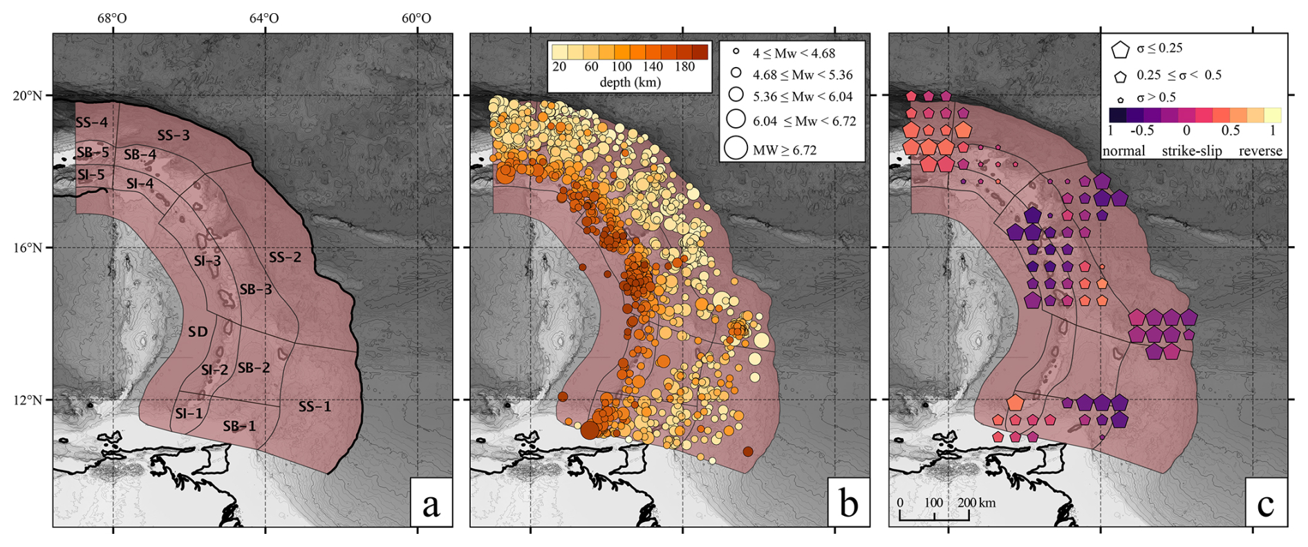
Figure 9Lesser Antilles intraslab seismotectonic zoning model. (a, b) The same as Fig. 4a, b but for intraslab seismicity. SS: shallow slab; SB: slab bending; SI: slab intermediate; SD: slab detachment. (c) Grid-average faulting style based on intraslab FMAnt2021 events, with symbol sizes inversely proportional to the standard deviation.
4.4 Mantle wedge seismotectonics and area sources
The Lesser Antilles subduction is characterized by a cold mantle wedge associated with normal-fault seismicity (Bie et al., 2022; Laigle et al., 2013b; Ruiz et al., 2013), as also observed in the Greece, Aotearoa / New Zealand, and northern Japan subductions (Uchida et al., 2010; Davey and Ristau, 2011; Halpaap et al., 2019, 2021). This peculiar “supra-slab” seismicity may be explained by the presence of pyroxenitic material within peridotites instead of aseismic serpentinized peridotite (Laigle et al., 2013b) or by subduction fluids from the slab source expelled to the mantle wedge (Halpaap et al., 2019) and could result in a cold mantle wedge (Hicks et al., 2023).
The mantle wedge seismicity is located ∼ 50 km east of the volcanic arc and between 25 and 60 km depth (Fig. 7d). Using the subducting slab and arc Moho geometries as limits, we identify over 3000 events associated with mantle wedge seismicity (Fig. 10b), allowing us to define four area sources where the bottom limit follows the slab surface minus 5 km down to 70 km depth and the top limit is limited by the crustal Moho at 28 km (Fig. 10a): a main mantle source (MS) from Saint Lucia to Barbuda characterized by high seismic activity, two southern and northern mantle sources (SMS, NMS) with lower seismic activity, and a Puerto Rico mantle source (PRM).

Figure 10Lesser Antilles mantle wedge seismotectonic zoning model. (a–c) The same as Fig. 4 but for the mantle wedge seismicity. MS: mantle source; NMS: north mantle source; PRM: Puerto Rico mantle. Focal mechanisms are from Ruiz et al. (2013).
The seismogenic potential of the mantle wedge is poorly constrained due to the large earthquake location uncertainties and the lack of dedicated studies (in the Lesser Antilles and worldwide). An OBS study offshore Guadeloupe and Martinique recorded two M=3.1 and M=3.6 mantle wedge earthquakes, with different orientations and fault types, over a 6-month period (Ruiz et al., 2013; Fig. 10c). The 8 October 1974 MS=7.1–7.6 earthquake location is estimated in the arc lower crust by McCann et al. (1982) (Fig. 2c), along a NE-striking, SE-dipping normal fault, but its focal depth of 35 km suggests a possible mantle wedge event, as the Moho depth beneath Antigua is imaged at 30 km depth (Schlaphorst et al., 2021). Worldwide, the Aotearoa / New Zealand subduction shows the largest recorded mantle wedge earthquake with a magnitude of M=4.5 (Davey and Ristau, 2011). Current work is being conducted to determine a proper seismic catalog based on waveform conversions (Foix et al., 2024).
4.5 Volcanic seismotectonics and area sources
Seismic hazard assessment for volcanic systems is challenging due to uncommon seismicity pattern laws, low earthquake magnitudes, and high volcanic edifice heterogeneity affecting seismic wave attenuations and strong motion laws (e.g., Peruzza et al., 2017). Worldwide, volcano-tectonic earthquakes are generally limited to M<5–6 (McNutt and Roman, 2015), even though earthquakes of up to M=6–7 have caused severe damage in Japan and Indonesia (Yokoyama, 2009) and have reached M=7.5–8 (e.g., 1990, Mount Pinatubo, Philippines).
The Lesser Antilles subduction system is marked by numerous volcanic eruptions and volcano-tectonic earthquakes. Seismo-volcanic crises were responsible for significant earthquakes and, in some cases, associated damage, such as the 1950–1951 Nevis crisis (Mw=4.3) (Willmore, 1952), the 1966–1967 Montserrat crisis with 32 felt earthquakes, the Guadeloupe Soufrière phreatic eruption in 1976–1977 (M=4.6), and unrest in 2017–2018 (ML = 4.1) (Moretti et al., 2020). In order to account for these events, we define specific circular source areas associated with the active volcanic edifices and seismicity using a simple 10 km radius definition and the crust thickness as the depth limit (Fig. 6).
Recent studies proposed alternative methods to analyze seismotectonics. Mazzotti et al. (2011) incorporate geodetic data to derive the strain rate and seismic moment rates. Beauval et al. (2018) use geologic and geodetic slip rates to characterize a weakly instrumented zone. In this study, we propose an updated seismotectonic zoning model for seismic hazard assessment in the Lesser Antilles, enriched by numerous recent improvements in the understanding of the regional seismotectonic context. We mixed traditional seismicity-based methods with geological and geodetic data. The zoning comprises area and fault sources for the upper plate and area sources for the subduction interface, the subducting plate, the mantle wedge, and volcanic centers. Major updates compared to previous studies (Martin and Combes, 2001; Bozzoni et al., 2011; Pagani et al., 2020b; Zimmerman et al., 2022) consist of (i) better depth resolutions, owing to new slab and upper-plate geometries; (ii) a specific area source for the Marie-Galante graben, based on combined new tectonic, seismic, and geodetic data; (iii) new propositions of mantle wedge and volcanic zoning; and (iv) fully revised area sources for the subduction interface based on the integration of geodetic and coral data in a combined seismotectonic zoning model. Positioning area source boundaries may result in underestimating seismic hazard over short and long return periods, from 50 to 105 years (Avital et al., 2018). To go further with PSHA calculations, we highly recommend adding an uncertainty in area source boundaries when it is possible. Alternative models may be used for PSHA estimations in regions with high levels of data and knowledge (e.g., California, Italy). In the Lesser Antilles, each subset of data is incomplete, which does not allow us to propose alternative zoning.
As well as the major updates listed above, we specifically compare our study to the seismotectonic zoning used for the French Lesser Antilles PSHA (Martin and Combes, 2001) and propose entirely revised upper-plate and intraslab zoning geometries (Fig. S5 in the Supplement). New knowledge on the geological context, Moho and slab geometries, seismicity catalogs and rates, and geodesy and seismic imaging allows us to propose a new zoning scheme. Only the trench and western volcanic arc zoning limits are consistent between the two models (Fig. S5 in the Supplement). The greatest change lies in the fact that we divide our model according to the subduction structure (upper-plate crust, interface, intraslab, mantle wedge, volcanoes), whereas Martin and Combes (2001) considered all the seismicity from 0 to 30 km depth to propose a “shallow” zoning. Recent seismotectonic zoning models also consider this subduction structure division (Zimmerman et al., 2022) as the seismicity of each domain presents specific characteristics, for instance in terms of maximum earthquake magnitude. Regarding outer-rise maximum-magnitude earthquake records around the world (e.g., Meng et al., 2012), we also decide to consider this region in our model in contrast to Martin and Combes (2001). We also exclude the division of the backarc region proposed by Martin and Combes (2001), as the sub-zones are not justified by a specific change in instrumental or historical seismic records or by specific fault data (activity, slip rate). Finally, our data set allows us to cover a larger area (Fig. S5 in the Supplement). This zoning model can also be used as wave attenuation laws in terms of seismic ground motion attenuation (e.g., Youngs et al., 1997).
Our study also highlights major remaining epistemic uncertainties and unknowns that can impact seismic hazard assessment, although the overall seismotectonics of the upper plate are relatively well defined in the few areas studied with dedicated surveys, given the very great structural heterogeneity observed. The specifics of most of the arc and forearc tectonics require further data collection and analyses. For example, an apparent velocity gradient of ∼ 0.6 ± 0.3 and 1.4 ± 0.4 mm yr−1 for the eastern and northern components is observed in geodetic data between Saint Lucia and Saint Vincent and the Grenadines, without an associated pulse of earthquake activity or known active faults. This points to the need for a more complete active fault and structural database of the whole Lesser Antilles arc and forearc.
Similarly, homogeneous earthquake catalogs with improved locations and magnitudes are an important requirement for both instrumental and historical seismicity. The ISCU-cat (Bertil, 2024) empirical magnitude conversion laws have been made by converting from ML or Md of the Trinidad seismological network (TRN) or from the Fort-de-France seismic station data (FDF – IPGP network) to Mw (Bertil et al., 2023). Conversions are calibrated on data recorded between 1986 and 2014. Since 2014, local magnitude (MLv) calculations from IPGP observatories have differed (Massin et al., 2021), and TRN magnitude conversions have to be verified. Thus, the Gutenberg–Richter distributions proposed in Fig. S3 in the Supplement are more qualitative than quantitative. Changes in slope observed between magnitudes 3 and 4 could be a completeness effect or also the result of inappropriate Md-to-Mw conversions. For the Virgin Islands, no Md-to-Mw conversion is available and Md = Mw is used directly (Bertil et al., 2023). These Gutenberg–Richter distributions (Fig. S3 in the Supplement) clearly illustrate that improvements in the magnitude conversions for M<4.0 are still needed. We consequently describe this distribution in three levels of confidence: usable, questionable, and unusable (Table S1 in the Supplement).
One of the major sources of epistemic uncertainty concerns the subduction interface, with its lack of instrumental large-earthquake records and its overall very low geodetic interseismic coupling. We faced a lack of geodetic measurements in this area, which is mainly underwater, despite recent efforts. Worldwide, low interseismic coupling associated with limited large-earthquake activity is observed in the Greece, Calabria, South Sandwich, and Mariana subduction zones (e.g., Vanneste and Larter, 2002; Vernant et al., 2014; Carafa et al., 2018). Yet, focal mechanisms indicate that the Lesser Antilles megathrust can generate moderate M=5–6 earthquakes, at least in its northern half. Coral data are sometimes interpreted as indicative of deep (∼ 40–65 km), high interseismic coupling (Philibosian et al., 2022) or as coherent with geodetic vertical motions with observed subsidence (van Rijsingen et al., 2022). Issues of potential temporal variations in interseismic coupling, as in Mexico or Sumatra (Villafuerte et al., 2021; Philibosian et al., 2022), and the relationship between interseismic coupling and great-earthquake potential (e.g., Kaneko et al., 2010) remain to be addressed. Efforts on seafloor geodesy measurements would help to enhance our understanding of the Lesser Antilles intercoupling behavior of the plate interface, and we highly recommend considering them for future oceanographic missions.
Finally, the uncommon seismicity sources identified in the mantle wedge and the volcanic centers also require dedicated studies before they can be fully integrated into seismic hazard assessments. In both cases, issues such as the earthquake maximum magnitudes and mechanisms or appropriate ground motion attenuation laws demand dedicated global and, if possible, local studies. For the latter, the recognition that shallow, moderate volcano-tectonic earthquakes can constitute a significant source of hazard implies the need for further studies of the influence of eruptive phases on the triggering of volcano-tectonic earthquakes. The 10 km radius around each volcano should be revisited to be more specific to each volcano's characteristics. The creation of a specific volcano-tectonic earthquake catalog from instrumental and historical records is necessary to better encompass their seismic activities. Volcanic seismicity from the two French volcanoes La Soufrière and Mount Pelée can be downloaded from the IPGP observatory servers. ISCU-cat may contain events from volcanic activity, such as the 1950 Mw=4.3 earthquake from the St Kitts and Nevis seismo-volcanic crisis or the 2020 Mw=3.6 earthquake from the St Vincent seismo-volcanic crisis (Didier Bertil, personal communication, 2023; Joseph et al., 2022). Seismic records may not be sufficient to calculate magnitude–frequency distributions and their associated attenuation laws.
A detailed report of the Lesser Antilles seismotectonic model and data are available in the OREME database, https://doi.org/10.15148/dd520135-7656-4e80-91fe-f0284accbc76 (Foix et al., 2023b).
The supplement related to this article is available online at https://doi.org/10.5194/nhess-25-1881-2025-supplement.
Lesser Antilles Working Group: Marie-Paule Bouin (Université de Paris, Institut de Physique du Globe de Paris, CNRS, 75005 Paris, France), Éric Calais (École normale supérieure, Département de Géosciences, CNRS, Paris, France), Jean-Jacques Cornée (Univ. Grenoble Alpes, Univ. Savoie Mont Blanc, CNRS, IRD, UGE, ISTerre, Grenoble, France), Nathalie Feuillet (Bureau de Recherche Géologique et Minière, Orléans, France), Roser Hoste-Colomer (Institut de Radioprotection et de Sûreté Nucléaire, PSE-ENV, SCAN, BERSSIN, Fontenay-aux-Roses, France), Mireille Laigle (Géoazur, Université Côte d'Azur, CNRS, IRD, Observatoire de la Côte d'Azur), Serge Lallemand (Univ. Grenoble Alpes, Univ. Savoie Mont Blanc, CNRS, IRD, UGE, ISTerre, Grenoble, France), Jean-Frédéric Lebrun (Univ. Grenoble Alpes, Univ. Savoie Mont Blanc, CNRS, IRD, UGE, ISTerre, Grenoble, France), Anne Lemoine (Institut de Radioprotection et de Sûreté Nucléaire, PSE-ENV, SCAN, BERSSIN, Fontenay-aux-Roses, France), Boris Marcaillou (Géoazur, Université Côte d'Azur, CNRS, IRD, Observatoire de la Côte d'Azur), Mélody Philippon (Univ. Grenoble Alpes, Univ. Savoie Mont Blanc, CNRS, IRD, UGE, ISTerre, Grenoble, France), Agathe Roullé (Université de Paris, Institut de Physique du Globe de Paris, CNRS, 75005 Paris, France), Claudio Satriano (Université de Paris, Institut de Physique du Globe de Paris, CNRS, 75005 Paris, France), Jean-Marie Saurel (Université de Paris, Institut de Physique du Globe de Paris, CNRS, 75005 Paris, France), Elenora van Rijsingen (Utrecht University, Department of Earth Sciences, the Netherlands).
OF: conceptualization, data curation, formal analysis, methodology, software, validation, visualization, original draft preparation, review and editing. SF: conceptualization, formal analysis, funding acquisition, methodology, software, visualization, original draft preparation, review. HJ: conceptualization, formal analysis, funding acquisition, methodology, original draft preparation, review. DB: data curation, formal analysis, methodology, original draft preparation, review. Lesser Antilles Working Group: data curation, review.
The contact author has declared that none of the authors has any competing interests.
Publisher's note: Copernicus Publications remains neutral with regard to jurisdictional claims made in the text, published maps, institutional affiliations, or any other geographical representation in this paper. While Copernicus Publications makes every effort to include appropriate place names, the final responsibility lies with the authors.
We express our gratitude to the Ministère de la transition écologique, de la biodiversité, de la forêt, de la mer et de la pêche for supporting this study (agreement number 2201258550) across the ATLAS project for the Lesser Antilles seismic hazard reassessment, and to the Epos-France consortium for its funding support. The figures were produced using the Generic Mapping Tools (Wessel et al., 2013), Affinity Designer, and Python and Microsoft Excel. We would like to thank the reviewers for their constructive criticism, which has helped to improve this paper.
This research has been supported by the Ministère de la transition écologique, de la biodiversité, de la forêt, de la mer et de la pêche (grant no. 2201258550 (DGPR)).
This paper was edited by Andreas Günther and reviewed by Lidong Bie and one anonymous referee.
Aitken, T., Mann, P., Escalona, A., and Christeson, G. L.: Evolution of the Grenada and Tobago basins and implications for arc migration, Mar. Petrol. Geol., 28, 235–258, https://doi.org/10.1016/j.marpetgeo.2009.10.003, 2011.
Allen, R., Collier, J., Henstock, T., Stewart, A., and Goes, S.: A new tectonic model for the Lesser Antilles: Evidence for a buried arc in the eastern Caribbean, European Geophysical Research Abstracts, Vol 21, EGU2019-7944, 2019.
Allen, R. W., Collier, J. S., Henstock, T. J., and The VoiLA Consortium: The role of crustal accretion variations in determining slab hydration at an Atlantic subduction zone, J. Geophys. Res.-Solid Earth, 127, e2022JB024349, https://doi.org/10.1029/2022JB024349, 2022.
Avital, M., Kamai, R., Davis, M., and Dor, O.: The effect of alternative seismotectonic models on PSHA results – a sensitivity study for two sites in Israel, Nat. Hazards Earth Syst. Sci., 18, 499–514, https://doi.org/10.5194/nhess-18-499-2018, 2018.
Baker, J. W., Bradley, B. A., and Stafford, P. J.: Seismic hazard and risk analysis, Cambridge University Press, https://doi.org/10.1017/9781108425056, 2021.
Bazin, S., Feuillet, N., Duclos, C., Crawford, W., Nercessian, A., Bengoubou-Valérius, M., Beauducel, F., and Singh, S. C.: The 2004–2005 Les Saintes (French West Indies) seismic aftershock sequence observed with ocean bottom seismometers, Tectonophysics, 489, 91–103, https://doi.org/10.1016/j.tecto.2010.04.005, 2010.
Beauval, C., Marinière, J., Yepes, H., Audin, L., Nocquet, J.-M., Alvarado, A., Baize, S., Aguilar, J., Singaucho, J.-C. and Jomard H.: A New Seismic Hazard Model for Ecuador, B. Seismol. Soc. Am., 108, 1443–1464, https://doi.org/10.1785/0120170259, 2018.
Beck, C., Reyss, J.-L., Leclerc, F., Moreno, E., Feuillet, N., Barrier, L., Beauducel, F., Boudon, G., Clément, V., Deplus, C., Gallou, N., Lebrun, J.-F., Le Friant, A., Nercessian, A., Paterne, M., Pichot, T., and Vidal, C.: Identification of deep subaqueous co-seismic scarps through specific coeval sedimentation in Lesser Antilles: implication for seismic hazard, Nat. Hazards Earth Syst. Sci., 12, 1755–1767, https://doi.org/10.5194/nhess-12-1755-2012, 2012.
Beck, S., Barrientos, S., Kausel, E., and Reyes, M.: Source characteristics of historic earthquakes along the central Chile subduction Askew et alzone, J. South Am. Earth Sci., 11, 115–129, https://doi.org/10.1016/S0895-9811(98)00005-4, 1998.
Bernard, P. and Lambert, J.: Subduction and seismic hazard in the northern Lesser Antilles: Revision of the historical seismicity, B. Seismol. Soc. Am., 78 1965–1983, https://doi.org/10.1785/BSSA0780061965, 1988.
Bertil, B., Lemoine, A., Hoste-Colomer, R., Lambert, J., Thomas, Y., and Roullé, A.: Base de données de sismicité historique SISFRANCE-Antilles, 10ème biennales du RAP (Réseau Accéléromètrique Permanent), Nov 2022, Vogüé, Ardèche, France, https://hal.science/hal-04662304v1 (last access: 2022), 2022.
Bertil, D., Lemoine, A., Lambert, J., and Hoste-Colomer, R. : Sismicité du sud de l'arc antillais : dichotomie entre le catalogue historique et le catalogue instrumental, 1er rencontres Epos-France, Abstract, 502262, https://epos-france-2023.sciencesconf.org/502262 (last access: 2023), 2023.
Bertil, D.: ISC-U Antilles instrumental seismicity catalogue (BRGM), https://doi.org/10.18144/7a1f2980-4440-4d4f-a78b-326acdb5e873, 2024.
Bie, L., Rietbrock, A., Hicks, S., Allen, R., Blundy, J., Clouard, V., Collier, J., Davidson, J., Garth, T., Goes, S., Harmon, N., Henstock, T., Van Hunen, J., Kendall, M., Krüger, F., Lynch, L., Macpherson, C., Robertson, R., Rychert, K., Tait, S., Wilkinson, J., and Wilson, M.: Along-arc heterogeneity in local seismicity across the Lesser Antilles subduction zone from a dense ocean-bottom seismometer network, Seismol. Res. Lett., 91, 237–247, https://doi.org/10.1785/0220190147, 2019.
Bie, L., Hicks, S., Rietbrock, A., Goes, S., Collier, J., Rychert, C., Harmon, N., and Maunder, B.: Imaging slab-transported fluids and their deep dehydration from seismic velocity tomography in the Lesser Antilles subduction zone, Earth Planet. Sci. Lett., 586, 117535, https://doi.org/10.1016/j.epsl.2022.117535, 2022.
Boucard, M., Marcaillou, B., Lebrun, J. F., Laurencin, M., Klingelhoefer, F., Laigle, M., Lallemand, S., Schenini, L., Graindorge, D., Cornée, J. J., Münch, P., Philippon, M., and the ANTITHESIS and GARANTI Scientific Teams: Paleogene V-Shaped Basins and Neogene Subsidence of the Northern Lesser Antilles Forearc, Tectonics, 40, e2020TC006524, https://doi.org/10.1029/2020TC006524, 2021.
Bozzoni, F., Corigliano, M., Lai, C. G., Salazar, W., Scandella, L., Zuccolo, E., Latchman, J., Lynch, L., and Robertson, R.: Probabilistic seismic hazard assessment at the eastern Caribbean Islands, B. Seismol. Soc. Am., 101, 2499–2521, https://doi.org/10.1785/0120100208, 2011.
Bradley, K. and Hubbard, J. A.: M5.5 offshore of Panama An unusual thrust earthquake along a mostly “quiet” subduction zone, Earthquake Insight, Earthquake Analysis, https://doi.org/10.62481/7597adcd, 2023.
Braszus, B., Goes, S., Allen, R., Rietbrock, A., Collier, J., Harmon, N., Henstock, T., Hicks, S., Rychert, C. A., Maunder, B., van Hunen, J., Bie, L., Blundy, J., Cooper, G., Davy, R., Kendall, J. M., Macpherson, C., Wilkinson, J., and Wilson, M.: Subduction history of the Caribbean from upper-mantle seismic imaging and plate reconstruction, Nat. Commun., 12, 4211, https://doi.org/10.1038/s41467-021-24413-0, 2021.
Brown, K. M. and Westbrook, G. K.: The tectonic fabric of the Barbados Ridge accretionary complex, Mar. Petrol. Geol., 4, 71–81, https://doi.org/10.1016/0264-8172(87)90022-5, 1987.
Carafa, M. M. C., Kastelic, V., Bird, P., Maesano, F. E., and Valensise, G.: A “Geodetic Gap” in the Calabrian Arc: Evidence for a Locked Subduction Megathrust?, Geophys. Res. Lett., 45, 1794–1804, https://doi.org/10.1002/2017GL076554, 2018.
Carey, S., Sparks, R. S. J., Tucker, M. E., Robinson, L., Watt, S., Gee, M., Hastie, A., Barfod, D. N., Stinton, A., Leng, A., Raineault, N., and Ballard, R. D.: The polygenetic Kahouanne Seamounts in the northern Lesser Antilles island arc, Mar. Geol., 419, 106046, https://doi.org/10.1016/j.margeo.2019.106046, 2019.
Christeson, G. L., Mann, P., Escalona, A., and Aitken, T. J.: Crustal structure of the Caribbean – Northeastern South America arc-continent collision zone, J. Geophys. Res.-Solid Earth, 113, B08104, https://doi.org/10.1029/2007JB005373, 2008.
Clouard, V., Roger, J., and Moizan, E.: Tsunami deposits in Martinique related to the 1755 Lisbon earthquake, Nat. Hazards Earth Syst. Sci. Discuss. [preprint], https://doi.org/10.5194/nhess-2017-238, 2017.
Corbeau, J., Gonzalez, O. L., Clouard, V., Rolandone, F., Leroy, S., Keir, D., Stuart, G., Momplaisir, R., Boisson, D., and Prépetit, C.: Is the local seismicity in western Hispaniola (Haiti) capable of imaging northern Caribbean subduction?, Geosphere, 15, 1738–1750, https://doi.org/10.1130/GES02083.1, 2019.
Corbeau, J., Gonzalez, O., Feuillet, N., Lejeune, A. M., Fontaine, F. R., Clouard, V., and Saurel, J. M.: A Significant Increase in Interplate Seismicity near Major Historical Earthquakes Offshore Martinique (FWI), B. Seismol. Soc. Am., 111, 3118–3135, https://doi.org/10.1785/0120200377, 2021.
Davey, F. J. and Ristau, J.: Fore-arc mantle wedge seismicity under northeast New Zealand, Tectonophysics, 509, 272–279, https://doi.org/10.1016/J.TECTO.2011.06.017, 2011.
DeMets, C., Gordon, R. G., and Argus, D. F.: Geologically current plate motions, Geophys. J. Int., 181, 1–80, https://doi.org/10.1111/J.1365-246X.2009.04491.X, 2010.
Deville, E.: Dynamics of Brittle-Viscous Accretionary Wedges as Revealed by Geophysical and Drilling Data and Analog Modeling of the Barbados Prism, Tectonics, 42, e2023TC007851, https://doi.org/10.1029/2023TC007851, 2023.
Dorel, J.: Seismicity and seismic gap in the Lesser Antilles arc and earthquake hazard in Guadeloupe, Geophys. J. Roy. Astro. Soc., 67, 679–695, https://doi.org/10.1111/j.1365-246X.1981.tb06947.x, 1981.
Dziewonski, A. M., Chou, T.-A., and Woodhouse, J. H.: Determination of earthquake source parameters from waveform data for studies of global and regional seismicity, J. Geophys. Res., 86, 2825–2852, https://doi.org/10.1029/JB086iB04p02825, 1981.
Ekström, G., Nettles, M., and Dziewonski, A. M.: The global CMT project 2004-2010: Centroid-moment tensors for 13,017 earthquakes, Phys. Earth Planet. Inter., 200–201, 1–9, https://doi.org/10.1016/j.pepi.2012.04.002, 2012.
Escartín, J., Leclerc, F., Olive, J.-A., Mevel, C., Cannat, M., Petersen, S., Augustin, N., Feuillet, N., Deplus, C., Bezos, A., Bonnemains, D., Chavagnac, V., Choi, Y., Godard, M., Haaga, K.A., Hamelin, C., Ildefonse, B., Jamieson, J.W., John, B.J., Leleu, T., MacLeod, C.J., Massot-Campos, M., Nomikou, P., Paquet, M., Rommevaux-Jestin, C., Rothenbeck, M., Steinführer, A., Tominaga, M., Triebe, L., Campos, R., Gracias, N., Garcia, R., Andreani, M., and Vilaseca, G.: First direct observation of coseismic slip and seafloor rupture along a submarine normal fault and implications for fault slip history, Earth Planet. Sci. Lett., 450, 96–107, https://doi.org/10.1016/j.epsl.2016.06.024, 2016.
Ezenwaka, K., Marcaillou, B., Laigle, M., Klingelhoefer, F., Lebrun, J. F., Paulatto, M., Biari, Y., Rolandone, F., Lucazeau, F., Heuret, A., Pichot, T., and Bouquerel, H.: Thermally constrained fluid circulation and seismicity in the Lesser Antilles subduction zone, Earth Planet. Sci. Lett., 597, 117823, https://doi.org/10.1016/J.EPSL.2022.117823, 2022.
Feuillet, N., Manighetti, I., and Tapponnier, P.: Extension active perpendiculaire à la subduction dans l'arc des Petites Antilles (Guadeloupe, Antilles françaises), Comptes Rendus de l'Académie Des Sciences – Series IIA – Earth and Planetary Science, 333, 583–590, https://doi.org/10.1016/S1251-8050(01)01543-9, 2001.
Feuillet, N., Manighetti, I., Tapponnier, P., and Jacques, E.: Arc parallel extension and localization of volcanic complexes in Guadeloupe, Lesser Antilles, J. Geophys. Res.-Solid Earth, 107, 2331, https://doi.org/10.1029/2001jb000308, 2002.
Feuillet, N., Tapponnier, P., Manighetti, I., Villemant, B., and King, G. C. P.: Differential uplift and tilt of Pleistocene reef platforms and Quaternary slip rate on the Morne-Piton normal fault (Guadeloupe, French West Indies), J. Geophys. Res.-Solid Earth, 109, B02404, https://doi.org/10.1029/2003jb002496, 2004.
Feuillet, N., Leclerc, F., Tapponnier, P., Beauducel, F., Boudon, G., le Friant, A., Deplus, C., Lebrun, J. F., Nercessian, A., Saurel, J. M., and Clément, V.: Active faulting induced by slip partitioning in Montserrat and link with volcanic activity: New insights from the 2009 GWADASEIS marine cruise data, Geophys. Res. Lett., 37, 1–6, https://doi.org/10.1029/2010GL042556, 2010.
Feuillet, N., Beauducel, F., and Tapponnier, P.: Tectonic context of moderate to large historical earthquakes in the Lesser Antilles and mechanical coupling with volcanoes, J. Geophys. Res.-Solid Earth, 116, 10308, https://doi.org/10.1029/2011JB008443, 2011a.
Feuillet, N., Beauducel, F., Jacques, E., Tapponnier, P., Delouis, B., Bazin, S., Vallée, M., and King, G. C. P.: The Mw = 6.3, November 21, 2004, les Saintes earthquake (Guadeloupe): Tectonic setting, slip model and static stress changes, J. Geophys. Res.-Solid Earth, 116, B10301, https://doi.org/10.1029/2011JB008310, 2011b.
Foix, O., Mazzotti, S., Jomard, H., Beauval, C., Bertil, D., Bouin, M.-P., Calais, E., Cornée, J.-J., Feuillet, N., Hoste-Colomer, R., Laigle, M., Lallemand, S., Lebrun, J.-F., Lemoine, A., Marcaillou, B., Philippon, M., Roulle, A., Satriano, C., Saurel, J.-M., and van Rijsingen, E.: A New Seismic Source Zone Model for Lesser Antilles Seismic Hazard Assessment. OSU OREME, Report, 62 p., Ministère de la Transition Écologique et de la Cohésion des Territoires, https://doi.org/10.15148/dd520135-7656-4e80-91fe-f0284accbc76, 2023a.
Foix, O., Mazzotti, S., and Jomard, H.: A New Seismic Source Zone Model for Lesser Antilles Seismic Hazard Assessment – Data, OSU OREME [data set], https://doi.org/10.15148/dd520135-7656-4e80-91fe-f0284accbc76, 2023b.
Foix, O., Haalpap, F., Rondenay, S., Bodin, T., Laigle, M., Ambrois, D., and Maufroy, E.: Mapping Mantle Wedge Seismicity from Waveform Conversions: The Case of the Lesser Antilles Subduction Zone, Biennale du RAP conference, Aussois, France (poster), https://doi.org/10.13140/RG.2.2.18175.07845, 2024.
Frankel, A., Chen, R., Petersen, M., Moschetti, M., and Sherrod, B.: Update of the Pacific Northwest Portion of the U.S. National Seismic Hazard Maps, Earthquake Spectra, 31, S131–S148, https://doi.org/10.1193/111314EQS193M, 2014.
Garrocq, C., Lallemand, S., Marcaillou, B., Lebrun, J. F., Padron, C., Klingelhoefer, F., Laigle, M., Münch, P., Gay, A., Schenini, L., Beslier, M. O., Cornée, J. J., Mercier de Lépinay, B., Quillévéré, F., BouDagher-Fadel, M., Agranier, A., Arcay, D., Audemard, F., Boucard, M., ... and Yates, B.: Genetic Relations Between the Aves Ridge and the Grenada Back-Arc Basin, East Caribbean Sea, J. Geophys. Res.-Solid Earth, 126, e2020JB020466, https://doi.org/10.1029/2020JB020466, 2021.
Gomez, S., Bird, D., and Mann, P.: Deep crustal structure and tectonic origin of the Tobago-Barbados ridge, Interpretation, 6, T471–T484, https://doi.org/10.1190/INT-2016-0176.1, 2018.
Gómez-Capera, A. A., Stucchi, M., Arcila, M., Bufaliza, M., Choy, J., Minaya, E., Leyton, L., Pirchiner, M., Rendón, H., Rodriguez, L., Sarabia, A., Tavera, H., Yepes, H., De, O., Calixto, S., and Paz, L.: Updated earthquake catalog for South America: Time window pre-1964, 16th World Conference on Earthquake, 16WCEE, 13 pp., https://www.wcee.nicee.org/wcee/article/16WCEE/WCEE2017-1332.pdf (last access: 2022), 2017.
González, O. L., Clouard, V., and Zahradnik, J.: Moment tensor solutions along the central Lesser Antilles using regional broadband stations, Tectonophysics, 717, 214–225, https://doi.org/10.1016/j.tecto.2017.06.02, 2017.
Graham, S. E., Loveless, J. P., and Meade, B. J.: A global set of subduction zone earthquake scenarios and recurrence intervals inferred from geodetically constrained block models of interseismic coupling distributions, Geochem. Geophys. Geosyst., 22, e2021GC009802, https://doi.org/10.1029/2021GC009802, 2021.
Gutscher, M. A., Westbrook, G. K., Marcaillou, B., Graindorge, D., Gailler, A., Pichot, T., and Maury, R. C.: How wide is the seismogenic zone of the Lesser Antilles forearc? B. Soc. Geol. Fr., 184, 47–59, https://doi.org/10.2113/gssgfbull.184.1-2.47, 2013.
Guy, M., Patton, J., Fee, J., Hearne, M., Martinez, E., Ketchum, D., Worden, C., Quitoriano, V., Hunter, E., Smoczyk, G., and Schwarz, S.: National Earthquake Information Center systems overview and integration, U.S. Geological Survey Open-File Report 2015–1120, p. 25, https://doi.org/10.3133/ofr20151120, 2015.
Halpaap, F., Rondenay, S., Perrin, A., Goes, S., Ottemöller, L., Austrheim, H., Shaw, R. and Eeken, T.: Earthquakes track subduction fluids from slab source to mantle wedge sink, Sci. Adv., 5, eaav7369, https://doi.org/10.1126/sciadv.aav736, 2019.
Halpaap, F., Rondenay, S., Liu, Q., Millet, F., and Ottemöller, L.: Toward waveform-based characterization of slab & mantle wedge (SAM) earthquakes, J. Geophys. Res.-Solid Earth, 126, e2020JB021573, https://doi.org/10.1029/2020JB021573, 2021.
Harris, C. W., Miller, M. S., and Porritt, R. W.: Tomographic imaging of slab segmentation and deformation in the Greater Antilles, Geochem. Geophys. Geosyst., 19, 2292–2307, https://doi.org/10.1029/2018GC007603, 2018.
Hasegawa, A., Nakajima, J., Uchida, N., Okada, T., Zhao, D., Matsuzawa, T., Umino, N.: Plate subduction, and generation of earthquakes and magmas in Japan as inferred from seismic observations: an overview, Gondwana Res., 16, 370–400, https://doi.org/10.1016/j.gr.2009.03.007, 2009.
Hayes, G. P., McNamara, D. E., Seidman, L., and Roger, J.: Quantifying potential earthquake and tsunami hazard in the Lesser Antilles subduction zone of the Caribbean region, Geophys. J. Int., 196, 510–521, https://doi.org/10.1093/GJI/GGT385, 2014.
Hicks, S. P., Bie, L., Rychert, C. A., Harmon, N., Goes, S., Rietbrock, A., Wei, S. S., Collier, J. S., Henstock, T. J., Lynch, L., Prytulak, J., Macpherson, C. G., Schlaphorst, D., Wilkinson, J. J., Blundy, J. D., Cooper, G. F., Davy, R. G., and Kendall, J.-M.: Slab to back-arc to arc: Fluid and melt pathways through the mantle wedge beneath the Lesser Antilles, Sci. Adv., 9, eadd2143, https://doi.org/10.1126/sciadv.add2143, 2023.
Hough, S. E.: Missing great earthquakes, J. Geophys. Res.-Solid Earth, 118, 1098–1108, https://doi.org/10.1002/jgrb.50083, 2013.
International Seismological Centre: ISC-GEM Earthquake Catalogue, https://doi.org/10.31905/d808b825, 2023.
IOC-UNESCO: Experts Meeting on Sources of Tsunamis in the Lesser Antilles Fort-de-France, Martinique (France) 18–20 March 2019, Workshop Reports, (291), 55 p., https://unesdoc.unesco.org/ark:/48223/pf0000374791 (last access: 2022), 2020.
Ito, Y. and Obara, K.: Dynamic deformation of the accretionary prism excites very low frequency earthquakes, Geophys. Res. Lett., 33, L02311, https://doi.org/10.1029/2005GL025270, 2006.
Jimeìnez, C.: Seismic source characteristics of the intraslab 2017 Chiapas-Mexico earthquake (Mw8.2), Phys. Earth Planet. Int., 280, 69-75, https://doi.org/10.1016/j.pepi.2018.04.013, 2018.
Joseph, E. P., Camejo-Harry, M., Christopher, T., Contreras-Arratia, R., Edwards, S., Graham, O., Johnson, M., Juman, A., Latchman, J. L., Lynch, L., Miller, V. L., Papadopoulos, I., Pascal, K., Robertson, R., Ryan, G. A., Stinton, A., Grandin, R., Hamling, I., Jo, M-J, Barclay, J., Cole, P., Davies, B. V., and Sparks, R. S. J.: Responding to eruptive transitions during the 2020–2021 eruption of La Soufrieíre volcano, St. Vincent, Nat. Commun., 13, 4129, https://doi.org/10.1038/s41467-022-31901-4, 2022.
Kanamori, H.: Seismological evidence for a lithospheric normal faulting - the Sanriku earthquake of 1933, Phys. Earth Planet. Int., 4, 289–300, https://doi.org/10.1016/0031-9201(71)90013-6, 1971.
Kaneko, Y., Avouac, J.-P., and Lapusta, N.: Towards inferring earthquake patterns from geodetic observations of interseismic coupling, Nat. Geosci., 3, 363–369, https://doi.org/10.1038/ngeo843, 2010.
Kopp, H., Weinzierl, W., Becel, A., Charvis, P., Evain, M., Flueh, E. R., Gailler, A., Galve, A., Hirn, A., Kandilarov, A., Klaeschen, D., Laigle, M., Papenberg, C., Planert, L., and Roux, E.: Deep structure of the central Lesser Antilles Island Arc: Relevance for the formation of continental crust, Earth Planet. Sci. Lett., 304, 121–134, https://doi.org/10.1016/j.epsl.2011.01.024, 2011.
Laigle, M., Lebrun, J.-F., and Hirn, A.: SISMANTILLES 2 cruise, RV L'Atalante, https://doi.org/10.17600/7010020, 2007.
Laigle, M., Becel, A., de Voogd, B., Sachpazi, M., Bayrakci, G., Lebrun, J. F., and Evain, M.: Along-arc segmentation and interaction of subducting ridges with the Lesser Antilles Subduction forearc crust revealed by MCS imaging, Tectonophysics, 603, 32–54, https://doi.org/10.1016/j.tecto.2013.05.028, 2013a.
Laigle, M., Hirn, A., Sapin, M., Bécel, A., Charvis, P., Flueh, E., Diaz, J., Lebrun, J. F., Gesret, A., Raffaele, R., Galvé, A., Evain, M., Ruiz, M., Kopp, H., Bayrakci, G., Weinzierl, W., Hello, Y., Lépine, J. C., Viodé, J. P., Sachpazi, M., Gallart, J., Kissling, E., and Nicolich, R.: Seismic structure and activity of the north-central Lesser Antilles subduction zone from an integrated approach: Similarities with the Tohoku forearc, Tectonophysics, 603, 1–20, https://doi.org/10.1016/j.tecto.2013.05.043, 2013b.
Lambert, J.: Base de données et sites internet SisFrance, Rapport final, BRGM/RP-58517-FR, http://infoterre.brgm.fr/rapports/RP-58517-FR.pdf (last access: 2021), 2009.
Lambert, J. and Samarcq, F.: SisFrance-Antilles database, Catalogue – entrepôt de données du BRGM, https://doi.org/10.18144/56615603-147f-43f3-bb13-c1f4356f1ded, 2024.
Lambert, J. and Terrier, M.: Historical tsunami database for France and its overseas territories, Nat. Hazards Earth Syst. Sci., 11, 1037–1046, https://doi.org/10.5194/nhess-11-1037-2011, 2011.
Laurencin, M., Marcaillou, B., Graindorge, D., Klingelhoefer, F., Lallemand, S., Laigle, M., and Lebrun, J. F.: The polyphased tectonic evolution of the Anegada Passage in the northern Lesser Antilles subduction zone, Tectonics, 36, 945–961, https://doi.org/10.1002/2017TC004511, 2017.
Laurencin, M., Graindorge, D., Klingelhoefer, F., Marcaillou, B., and Evain, M.: Influence of increasing convergence obliquity and shallow slab geometry onto tectonic deformation and seismogenic behavior along the Northern Lesser Antilles zone, Earth Planet. Sci. Lett., 492, 59–72, https://doi.org/10.1016/J.EPSL.2018.03.048, 2018.
Laurencin, M., Marcaillou, B., Graindorge, D., Lebrun, J. F., Klingelhoefer, F., Boucard, M., Laigle, M., Lallemand, S., and Schenini, L.: The Bunce Fault and Strain Partitioning in the Northern Lesser Antilles, Geophys. Res. Lett., 46, 9573–9582, https://doi.org/10.1029/2019GL083490, 2019.
Lay, T., Kanamori, H., Ammon, C. J., Koper, K. D., Hutko, A. R., Ye, L., Yue, H., and Rushing, T. M.: Depth-varying rupture properties of subduction zone megathrust faults, J. Geophys. Res.-Solid Earth, 117, B04311, https://doi.org/10.1029/2011JB009133, 2012.
Leclerc, F. and Feuillet, N.: Quaternary coral reef complexes as powerful markers of long-term subsidence related to deep processes at subduction zones: Insights from Les Saintes (Guadeloupe, French West Indies), Geosphere, 15, 983–1007, https://doi.org/10.1130/GES02069.1, 2019.
Leclerc, F., Feuillet, N., and Deplus, C.: Interactions between active faulting, volcanism, and sedimentary processes at an island arc: Insights from Les Saintes channel, Lesser Antilles arc, Geochem. Geophys. Geosyst., 17, 2781–2802, https://doi.org/10.1002/2016GC006337, 2016.
Lentas, K.: Towards routine determination of focal mechanisms obtained from first motion P-wave arrivals, Geophys. J. Int., 212, 1665–1686, https://doi.org/10.1093/gji/ggx503, 2018.
Lentas, K., Di Giacomo, D., Harris, J., and Storchak, D. A.: The ISC Bulletin as a comprehensive source of earthquake source mechanisms, Earth Syst. Sci. Data, 11, 565–578, https://doi.org/10.5194/essd-11-565-2019, 2019.
Le Roy, S., Lemoine, A., Nachbaur, A., Legendre, Y., Lambert, J., and Terrier, M.: Détermination de la submersion marine liée aux tsunamis en Martinique, BRGM/RP-66547-FR, http://infoterre.brgm.fr/rapports//RP-66547-FR.pdf (last access: 2022), 2017.
Lindner, M., Rietbrock, A., Bie, L., Goes, S., Collier, J., Rychert, C., Harmon, N., Hicks, S. P., Henstock, T., and the VoiLA working group: Bayesian regional moment tensor from ocean bottom seismograms recorded in the Lesser Antilles: Implications for regional stress field, Geophys. J. Int., 233, 1036–1054, https://doi.org/10.1093/gji/ggac494, 2023.
Malusà, M. G., Zhao, L., Eva, E., Solarino, S., Paul, A., Guillot, S., and Zhu, R.: Earthquakes in the western Alpine mantle wedge, Gondwana Res., 44, 89–95, https://doi.org/10.1016/j.gr.2016.11.012, 2016.
Mann, P., Schubert, C., and Burke, K.: Review of Caribbean neotectonics, in: The Caribbean Region, edited by: Dengo, G. and Case, J. E., The Geological Society of America, 307–338, https://doi.org/10.1130/DNAG-GNA-H.307, 1991.
Marcaillou, B., Klingelhoefer, F., Laurencin, M., Lebrun, J.-F., Laigle, M., Lallemand, S., Schenini, L., Gay, A., Boucard, M., Ezenwaka, K., and Graindorge, D.: Pervasive detachment faults within the slow spreading oceanic crust at the poorly coupled Antilles subduction zone, Commun. Earth Environ., 2, 203, https://doi.org/10.1038/s43247-021-00269-6, 2021.
Martin, C. and Combes, P.: Révision du zonage sismique de la France, Étude probabiliste, Rapport final, Contrat GTR/MATE/0701-150, https://side.developpement-durable.gouv.fr/Default/doc/SYRACUSE/67556 (last access: 2022), 2001.
Massin, F., Clouard, V., Vorobieva, I., Beauducel, F., Saurel, J. M., Satriano, C., Bouin, M. P., and Bertil, D.: Automatic picking and probabilistic location for earthquake assessment in the lesser antilles subduction zone (1972–2012), in: Comptes Rendus – Geoscience (Vol. 353, Issue S1), Académie des sciences, https://doi.org/10.5802/crgeos.81, 2021.
Mazzotti, S. and Adams, J.: Rates and uncertainties on seismic moment and deformation in eastern Canada, J. Geophys. Res., 110, B09301, https://doi.org/10.1029/2004JB003510, 2005.
Mazzotti, S., Leonard, L. J., Cassidy, J. F., Rogers, G. C., and Halchuk, S.: Seismic Hazard in Western Canada from GPS Strain Rates versus Earthquake Catalog, J. Geophys. Res.-Solid Eart, 116, B12310, https://doi.org/10.1029/2011JB008213, 2011.
Mazzotti, S., Aubagnac, C., Bollinger, L., Coca Oscanoa, K., Delouis, B., do Paco, D., Doubre, C., Godano, M., Jomard, H., Larroque, C., Laurendeau, A., Masson, F., Sylvander, M., and Trilla, A.: FMHex20: An earthquake focal mechanism database for seismotectonic analyses in metropolitan France and bordering regions, BSGF – Earth Sciences Bulletin, 192, https://doi.org/10.1051/bsgf/2020049, 2021.
McCann, W. R., Dewey, J. W., Murphy, A. J., and Harding, S. T.: A large normal-fault earthquake in the overriding wedge of the Lesser Antilles subduction zone: the earthquake of 8 October 1974, B. Seismol. Soc. Am., 72, 2267–2283, https://doi.org/10.1785/BSSA07206A2267, 1982.
McCann, W. R., Sykes, L. R., McCann, W. R., and Sykes, L. R.: Subduction of aseismic ridges beneath the Caribbean Plate: Implications for the tectonics and seismic potential of the northeastern Caribbean, J. Geoph. Res., 89, 4493–4519, https://doi.org/10.1029/JB089IB06P04493, 1984.
McNutt, S. R. and Roman, D. C.: Volcanic Seismicity, In The Encyclopedia of Volcanoes (1011–1034), Elsevier, https://doi.org/10.1016/b978-0-12-385938-9.00059-6, 2015.
Meng, L., Ampuero, J.-P., Stock, J., Duputel, Z., Luo, Y., and Tsai, V. C.: Earthquake in a Maze: Compressional Rupture Branching During the 2012 Mw 8.6 Sumatra Earthquake, Science, 337, 724–726, https://doi.org/10.1126/science.1224030, 2012.
Moretti, R., Komorowski, J., Ucciani, G., Moune, S., Jessop, D.E., de Chabalier, J., Beauducel, F., Bonifacie, M., Burtin, A., Vallée, M., Deroussi, S., Robert, V., Gibert, D., Didier, T., Kitou, T., Feuillet, N., Allard, P., Tamburello, G., Shreve, T., Saurel, J., Lemarchand, A., Rosas-Carbajal, M., Agrinier, P., Le Friant, A., and Chaussidon, M. : The 2018 unrest phase at La Soufrière of Guadeloupe (French West Indies) andesitic volcano: Scrutiny of a failed but prodromal phreatic eruption, J. Volcanol. Geotherm. Res., 393, 106769, https://doi.org/10.1016/j.jvolgeores.2020.106769, 2020.
Obana, K. and Kodaira, S.: Low-frequency tremors associated with reverse faults in a shallow accretionary prism, Earth Planet. Sci. Lett., 287, 168–174, https://doi.org/10.1016/j.epsl.2009.08.005, 2009.
Pagani, M., Johnson, K., and Palaez, J.: Modelling subduction sources for probabilistic seismic hazard analysis, Geological Society, London, Special Publications, 501, SP501-2019, https://doi.org/10.1144/SP501-2019-120, 2020a.
Pagani, M., Garcia-Pelaez, J., Gee, R., Johnson, K., Poggi, V., Silva, V., Simionato, M., Styron, R., Viganò, D., Danciu, L., Monelli, D., and Weatherill, G.: The 2018 version of the Global Earthquake Model: Hazard component, Earthquake Spectra, 36, 226–251, https://doi.org/10.1177/8755293020931866, 2020b.
Patriat, M., Pichot, T., Westbrook, G. K., Umber, M., Deville, E., Bénard, F., Roest, W. R., and Loubrieu, B.: Evidence for Quaternary convergence across the North America – South America plate boundary zone, east of the Lesser Antilles, Geology, 39, 979–982, https://doi.org/10.1130/G32474.1, 2011.
Paulatto, M., Laigle, M., Galve, A., Charvis, P., Sapin, M., Bayrakci, G., Evain, M., and Kopp, H.: Dehydration of subducting slow-spread oceanic lithosphere in the Lesser Antilles, Nat. Commun., 8, 15980, https://doi.org/10.1038/ncomms15980, 2017.
Peruzza, L., Azzaro, R., Gee, R., D'Amico, S., Langer, H., Lombardo, G., Pace, B., Pagani, M., Panzera, F., Ordaz, M., Suarez, M. L., and Tusa, G.: When probabilistic seismic hazard climbs volcanoes: the Mt. Etna case, Italy – Part 2: Computational implementation and first results, Nat. Hazards Earth Syst. Sci., 17, 1999–2015, https://doi.org/10.5194/nhess-17-1999-2017, 2017.
Philibosian, B., Feuillet, N., Weil-Accardo, J., Jacques, E., Guihou, A., Mériaux, A. S., Anglade, A., Saurel, J. M., and Deroussi, S.: 20th-century strain accumulation on the Lesser Antilles megathrust based on coral microatolls, Earth Planet. Sci. Lett., 579, 117343, https://doi.org/10.1016/j.epsl.2021.117343, 2022.
Philippon, M., Roger, J., Lebrun, J.-F., Thinon, I., Foix, O., Mazzotti, S., Gutscher, M.-A., Montheil, L., and Cornée, J.-J.: Forearc crustal faults as tsunami sources in the upper plate of the Lesser Antilles subduction zone: the case study of the Morne Piton fault system, Nat. Hazards Earth Syst. Sci., 24, 3129–3154, https://doi.org/10.5194/nhess-24-3129-2024, 2024.
Pichot, T., Patriat, M., Westbrook, G. K., Nalpas, T., Gutscher, M. A., Roest, W. R., Deville, E., Moulin, M., Aslanian, D., and Rabineau, M.: The Cenozoic tectonostratigraphic evolution of the Barracuda Ridge and Tiburon Rise, at the western end of the North America-South America plate boundary zone, Mar. Geol., 303–306, 154–171, https://doi.org/10.1016/j.margeo.2012.02.001, 2012.
Régnier, J., Michel, C., Bertrand, E., and Guéguen, P.: Contribution of ambient vibration recordings (Free-field and buildings) for post-seismic analysis: the case of the Mw 7.3 Martinique (French Lesser Antilles) earthquake, November 29, 2007, Soil Dynam. Earthq. Eng., 50, 162–167, https://doi.org/10.1016/j.soildyn.2013.03.007, 2013.
Ruiz, M., Galve, A., Monfret, T., Sapin, M., Charvis, P., Laigle, M., Evain, M., Hirn, A., Flueh, E., Gallart, J., Diaz, J., and Lebrun, J. F.: Seismic activity offshore Martinique and Dominica islands (Central Lesser Antilles subduction zone) from temporary onshore and offshore seismic networks, Tectonophysics, 603, 68–78, https://doi.org/10.1016/j.tecto.2011.08.006, 2013.
Russo, R. M., Okal, E. A., and Rowley, K. C.: Historical seismicity of the southeastern Caribbean and tectonic implications, Pure and Applied Geophysics PAGEOPH, 139, 87–120, https://doi.org/10.1007/BF00876827, 1992.
Saurel, J.-M., Bouin, M.-P., Satriano, C., Lemarchand, A., OVSG Team, and OVSM Team: 2014–2019 Antilles IPGP merged seismic catalog, in: IPGP Research Collection, V1, https://doi.org/10.18715/IPGP.2022.l3ylhaal, 2022.
Schlaphorst, D., Harmon, N., Kendall, J. M., Rychert, C. A., Collier, J., Rietbrock, A., Goes, S., and the VoiLA Team: Variation in upper plate crustal and lithospheric mantle structure in the Greater and Lesser Antilles from ambient noise tomography, Geochem. Geophys. Geosyst., 22, e2021GC009800, https://doi.org/10.1029/2021GC009800, 2021.
Schlupp, A., Sira, C., Cara, M., Bazin, S., Michel, C., Régnier, J., Beauval, C., Feuillet, N., de Chabalier, J.-B., Barras, A.-V., Auclair, S., Bouin, M.-P., Duclos, C., and Granet, M. : Séisme de Martinique, 29 novembre 2007, Rapport du BCSF: synthèse sismologique et étude macrosismique, BCSF-RENASS, https://hal.science/hal-03112999 (last access: 2022), 2008.
Sedan, O. and Terrier, M.: Travaux de reconnaissance pour l'étude de paléosismicité de la faille du May (Guadeloupe), BRGM/RP-51420-FR, http://infoterre.brgm.fr/rapports//RP-51420-FR.pdf (last access: 2022), 2001.
Seibert, C., Feuillet, N., Ratzov, G., Beck, C., Morena, P., Johannes, L., Ducassou, E., Cattaneo, A., Goldfinger, C., Moreno, E., Bieber, A., Bénâtre, G. Caron, B., Caron, M., Casse, M., Cavailhes, T., Del Manzo, G., Deschamps, C. E., Desiage, P. A., Duboc, Q., Fauquembergue, K., Ferrant, A., Guyard, H., Jacques, E., Laurencin, M., Leclerc, F., Patton, J., Saurel, J. M., St-Onge, G. and Woerther, P.: Sedimentary records in the Lesser Antilles fore-arc basins provide evidence of large late Quaternary megathrust earthquakes, Geochem. Geophys. Geosyst., 25, e2023GC011152, https://doi.org/10.1029/2023GC011152, 2024
Speed, R. C. and Larue, D. K.: Barbados: Architecture and implications for accretion, J. Geophys. Res., 87, 3633–3643, https://doi.org/10.1029/JB087iB05p03633, 1982.
Stein, S., Engeln, J. F., Wiens, D. A., Fujita, K., and Speed, R. C.: Subduction seismicity and tectonics in the Lesser Antilles Arc, J. Geophys. Res., 87, 8642–8664, https://doi.org/10.1029/JB087iB10p08642, 1982.
Styron, R., García-Pelaez, J., and Pagani, M.: CCAF-DB: the Caribbean and Central American active fault database, Nat. Hazards Earth Syst. Sci., 20, 831–857, https://doi.org/10.5194/nhess-20-831-2020, 2020.
Symithe, S., Calais, E., De Chabalier, J. B., Robertson, R., and Higgins, M.: Current block motions and strain accumulation on active faults in the Caribbean, J. Geophys. Res.-Solid Earth, 120, 3748–3774, https://doi.org/10.1002/2014JB01177, 2015.
ten Brink, U. and Lin, J.: Stress interaction between subduction earthquakes and forearc strike-slip faults: Modelling and application to the northern Caribbean plate boundary, J. Geophys. Res.-Solid Earth, 109, 1–15, https://doi.org/10.1029/2004JB003031, 2004.
Terrier, M.: Microzonage des communes de Fort-de-France – Schoelcher – le Lamentin: Failles actives, BRGM R38988, 52 p., https://docslib.org/doc/4225371/microzon-age-des-communes-de-fort-de-france-schoelcher (last access: 2022), 1996.
Uchida, N., Kirby, S. H., Okada, T., Hino, R., and Hasegawa, A.: Supraslab earthquake clusters above the subduction plate boundary offshore Sanriku, northeastern Japan: Seismogenesis in a graveyard of detached seamounts? J. Geophys. Res.-Solid Earth, 115, B09308, https://doi.org/10.1029/2009JB006797, 2010.
van Rijsingen, E. M., Calais, E., Jolivet, R., de Chabalier, J. B., Jara, J., Symithe, S., Robertson, R., and Ryan, G. A.: Inferring Interseismic Coupling Along the Lesser Antilles Arc: A Bayesian Approach, J. Geophys. Res.-Solid Earth, 126, e2020JB020677, https://doi.org/10.1029/2020JB020677, 2021.
van Rijsingen, E. M., Calais, E., Jolivet, R., de Chabalier, J. B., Robertson, R., Ryan, G. A., and Symithe, S.: Ongoing tectonic subsidence in the Lesser Antilles subduction zone, Geophys. J. Int., 231, 319–326, https://doi.org/10.1093/GJI/GGAC192, 2022.
Vanneste, L. E. and Larter, R. D.: Sediment subduction, subduction erosion, and strain regime in the northern South Sandwich forearc, J. Geophys. Res.-Solid Earth, 107, EPM 5-1-EPM 5-24, https://doi.org/10.1029/2001JB000396, 2002.
Vermeersch, F., Lambert, J., Fabris, H., and Legendre, D.: Mise en œuvre du projet “ SisDom ”. Base de données de la sismicité historique des Antilles françaises et de la mer Caraïbe, BRGM/RP-51543-FR, 48p., http://infoterre.brgm.fr/rapports/RP-51543-FR.pdf (last access: 2021), 2002.
Vernant, P., Reilinger, R., and McClusky, S.: Geodetic evidence for low coupling on the Hellenic subduction plate interface, Earth Planet. Sci. Lett., 385, 122–129, https://doi.org/10.1016/J.EPSL.2013.10.018, 2014.
Villafuerte, C., Cruz-Atienza, V. M., Tago, J., Solano-Rojas, D., Franco, S., Garza-Girón, R., Dominguez, L. A., and Kostoglodov, V.: Slow slip events and megathrust coupling changes reveal the earthquake potential before the 2020 Mw 7.4 Huatulco, Mexico, event, ESS Open Archive, https://doi.org/10.1002/essoar.10504796.1, 2021.
Weil-Accardo, J., Feuillet, N., Jacques, E., Deschamps, P., Beauducel, F., Cabioch, G., Tapponnier, P., Saurel, J. M., and Galetzka, J.: Two hundred thirty years of relative sea level changes due to climate and megathrust tectonics recorded in coral microatolls of Martinique (French West Indies), J. Geophys. Res.-Solid Earth, 121, 2873–2903, https://doi.org/10.1002/2015JB012406, 2016.
Wells, D. L. and Coppersmith, K. J.: New Empirical Relationships among Magnitude, Rupture Length, Rupture Width, Rupture Area, and Surface Displacement, B. Seismol. Soc. Am., 84, 974–1002, https://doi.org/10.1785/BSSA0840040974, 1994.
Wessel, P., Smith, W. H. F., Scharroo, R., Luis, J., and Wobbe, F.: Generic mapping tools: improved version released, EOS Trans. AGU 94, 409–410, https://doi.org/10.1002/2013EO450001, 2013.
Willmore, P. L.: The Earthquake Series in St. Kitts-Nevis, 1950–51: With Notes on Soufrière Activity in the Lesser Antilles, Nature, 169, 770–772, https://doi.org/10.1038/169770a0, 1952.
Wirth, E. A., Sahakian, V. J., Wallace, L. M., and Melnick, D.: The occurrence and hazards of great subduction zone earthquakes, Nat. Rev. Earth Environ., 3, 125–140, https://doi.org/10.1038/s43017-021-00245-w, 2022.
Yokoyama, I.: The largest magnitudes of earthquakes associated with some historical volcanic eruptions and their volcanological significance, Ann. Geophys., 44, 1021–1029, https://doi.org/10.4401/ag-3553, 2009.
Youngs, R. R., Chiou, S. J., Silva, W. J., and Humphrey, J. R.: Strong Ground Motion Attenuation Relationships for Subduction Zone Earthquakes, Seismol. Res. Lett., 68, 58–73, https://doi.org/10.1785/GSSRL.68.1.58, 1997.
Zimmerman, M. T., Shen-Tu, B., Shabestari, K., and Mahdyiar, M.: A Comprehensive Hazard Assessment of the Caribbean Region, B. Seismol. Soc. Am., 112, 1120–1148, https://doi.org/10.1785/0120210157, 2022.
The requested paper has a corresponding corrigendum published. Please read the corrigendum first before downloading the article.
- Article
(13183 KB) - Full-text XML
- Corrigendum
-
Supplement
(3217 KB) - BibTeX
- EndNote