the Creative Commons Attribution 4.0 License.
the Creative Commons Attribution 4.0 License.
 | 03 Jun 2025
Review article: Applicability and effectiveness of structural measures for subsidence (risk) reduction in urban areas
Nicoletta Nappo
Mandy Korff
Managing subsidence and its impacts on cities in coastal and delta areas is a global challenge that requires comprehensive risk reduction policies, including both mitigation and prevention strategies. Urban areas often lack systematic methodologies for determining appropriate countermeasures. This paper proposes a twofold strategy for selecting subsidence reduction measures in urban areas – which refer to structural (i.e. technical) measures to prevent and mitigate subsidence and its physical consequences – based on their applicability and performance. The question-and-response (Q&R) system serves as a decision tree to identify suitable subsidence countermeasures based on their applicability to specific cases. Four indicators of effectiveness – i.e. reduction potential, operational reliability, negative impact, and service life – are then used to assess the performance of subsidence reduction measures. The proposed procedure was applied to 49 cases derived from a review of 52 scientific publications and additional expert sessions and surveys involving 5 academic scholars and 13 experts. Also, the method was applied to examples from Shanghai (China), Jakarta (Indonesia), and the San Joaquin Valley (USA, California). The strategies proposed in this paper proved suitable for an initial screening of subsidence reduction measures applicable in different urban areas, after which a site-specific assessment can follow. Furthermore, this study shows the need to collect and share experiences in evaluating the performance of subsidence reduction measures more systematically and gives a first framework to do so.
- Article
(1935 KB) - Full-text XML
- BibTeX
- EndNote


Mexico City (Mexico), Jakarta (Indonesia), Bangkok (Thailand), Venice (Italy), New Orleans (USA, Louisiana), Lagos (Nigeria), Hokkaido (Japan), Shanghai (China), and Gouda (Netherlands) are examples of cities affected by subsidence (Bagheri-Gavkosh et al., 2021; Bucx et al., 2015; Davydzenka et al., 2023; Dinar et al., 2021; Erkens et al., 2015; Herrera-García et al., 2021; Hutabarat and Ilyas, 2017; Pedretti et al., 2024; Poland, 1984). The sinking rates in these cities span a few millimetres (for example in Gouda) to tens of centimetres (for example in Jakarta), causing socio-economic distress and environmental and structural damage (Erkens et al., 2015). The drivers of subsidence are generally distinguished as being natural or anthropogenic, although their combination is often the cause of negative impacts in cities (Galloway and Burbey, 2011). Natural causes typically include consolidation of compressible soils, shrinking and swelling of cohesive soils, decomposition of organic soils, groundwater discharge, and karst and tectonic processes (Gambolati and Teatini, 2021; Poland, 1984). Groundwater withdrawal, gas or oil extraction, mining, underground excavations, and urban sprawl and construction loading are anthropogenic factors causing or exacerbating subsidence processes (Gambolati and Teatini, 2021; Poland, 1984). Moreover, the combination of subsidence with sea-level rise and climate change increases the exposure of cities to additional risks, such as flooding (Herrera-García et al., 2021).
Unlike other geological or geophysical hazards with immediate disastrous impacts (e.g. earthquakes, landslides), subsidence is a relatively slow process with moderate intensity that can take decades to turn into a disaster (UNDRR, 2024). For this reason, subsidence is often unnoticed and not acknowledged as a disaster, and its physical, socio-economic, and environmental impacts in urban areas are not perceived as a potential catastrophe (Bucx et al., 2015; Erkens et al., 2015; Kok and Costa, 2021). Nevertheless, small- to large-scale subsidence can cause costly short- to long-term negative effects to cities that deserve proper (risk) management and reduction policies (Herrera-García et al., 2021). Several authors (Bucx et al., 2015; Department of Regional NSW, 2023; Erkens and Stouthamer, 2020; Jin et al., 2024; Kok and Costa, 2021; Peduto et al., 2015; Piper, 2021; United Nations, 2015) proposed frameworks for subsidence (risk) management, outlining four primary steps.
-
Problem analysis. This involves data collection and analysis, determination of subsidence causes, damage assessment, and (inverse) predictive modelling.
-
Planning. This step encompasses scenario construction, vulnerability and risk assessment, cost–benefit analysis, forecasting, decision support systems, proposing innovative (alternative) solutions, exchanging knowledge and best practices, and selection of mitigation and prevention measures.
-
Implementation. This involves installing monitoring systems, starting pilot projects, and implementing mitigation and prevention measures.
-
Evaluation. The final step is dedicated to the assessment of the management cycle and outlook.
Most of the research activities reported in the literature (63 %) focus on measuring and monitoring subsidence in urban areas using ground-based (e.g. levelling, GPS, extensometers) and remote sensing techniques (such as interferometric synthetic aperture radar (InSAR) and lidar; e.g. Ezquerro et al., 2020; Herrera et al., 2010; Ikuemonisan et al., 2021; López-Quiroz et al., 2009; Nappo et al., 2021; Peduto et al., 2019), while 30 % report on modelling and forecasting and only 7 % provide examples of cities where mitigation and prevention measures are applied (Scopus, 2024).
Technical interventions are commonly employed to protect major cities from subsidence; however, a systematic and objective method for selecting suitable solutions has not yet been established. Additionally, because of the diversity of mitigation and prevention methods, subsidence characteristics, and impacted (infra)structures and societies, evaluating the short- and long-term performance of subsidence countermeasures remains challenging. From this perspective, this paper aims at bridging this gap by proposing a twofold strategy to select mitigation and prevention measures based on their applicability and performance. First, a question-and-response (Q&R) system is proposed to identify suitable subsidence mitigation and prevention measures tailored to the specific requirements of each case. Then, by leveraging methods used to assess the effectiveness of mitigation measures against earthquakes, snow avalanches, landslides, and floods (Bründl et al., 2016; Hudson et al., 2014; Januriyadi et al., 2020; Margreth and Romang, 2010), this paper introduces four indicators to evaluate the effectiveness of selected subsidence countermeasures. This paper focuses on structural (i.e. technical) measures to counteract subsidence risk in urban areas, addressing both ground settlements and the resulting physical consequences (i.e. damage) to structures. With few adjustments, the proposed methodology could be adapted for non-structural (i.e. non-technical) measures, socio-economic and environmental effects, or subsidence countermeasures in rural areas; this however is not the aim of this paper.
Following this Introduction, the paper is structured as follows: Sect. 2 recalls the definitions of reduction, mitigation, prevention, and adaptation used in this study; Sect. 3 presents the collected data; Sect. 4 introduces the Q&R system and the indicators of effectiveness; Sect. 5 applies the methodology to selected cases and analyses the obtained results; and Sects. 6 and 7, respectively, discuss and conclude this paper. A brief description of measures to counteract subsidence and its physical consequences in urban areas is provided in Appendix A.
The definitions of terms given hereafter are based on the United Nations Multilingual Terminology Database (UNTERM, 2024) and the Sendai Framework Terminology on Disaster Risk Reduction (UNDRR, 2024). These definitions strictly refer to subsidence risk management; therefore, some of them may differ in other contexts, such as in climate change policies and civil structural engineering.
-
Reduction. These are strategies to decrease or remove the risk of subsidence by acting on the predisposing factors, magnitude, intensity, or frequency of subsidence or on the vulnerability and exposure of urban areas affected by it. Subsidence reduction measures encompass both mitigation and prevention measures.
-
Mitigation. These are structural and non-structural measures taken to minimize subsidence and its adverse impacts (e.g. damage) that cannot be entirely prevented. In urban areas, mitigation examples include repairing cracks in buildings following ground settlements or re-injecting fluids into aquifers after extraction.
-
Prevention. These are structural and non-structural measures taken to entirely avoid subsidence and its adverse impacts (e.g. damage) and to avert cascading effects such as sinkholes or increased flood risk. In urban areas, prevention examples include using deep foundations for buildings in soft soils or enhancing soil strength before construction.
-
Adaptation. This involves adjusting to the adverse impacts of subsidence or its evolving conditions that cannot be avoided or modified. This term is mainly used in the field of climate change. For subsidence in urban areas, it refers to non-structural measures.
-
Structural and non-structural measures. This is a set of technical interventions and non-technical strategies employed to cope with new or existing subsidence and its (potential) disastrous consequences. Structural interventions involve hazard-resistant physical structures and engineering techniques to withstand the physical impacts of subsidence. Non-structural measures include laws, regulations, alternative urban planning, public awareness initiatives, and environmental and social policies. The term “structural and non-structural measures” in subsidence risk management differs from its usage in civil and structural engineering.
Other terms such as “remedial”, “reparative”, “precautionary”, “protective”, or “compensatory” measures to “control or arrest” subsidence and its physical consequences can be found in the literature (Nutalaya et al., 1996; Poland, 1984; Singh and Dhar, 1997; Stouthamer et al., 2020; Zektser et al., 2005), referring to what here is defined as “mitigation” and “prevention” measures.
It should be noted that, in this paper, the terms “subsidence countermeasures” and “subsidence reduction measures” are used interchangeably. Both terms refer to mitigation and prevention measures employed in urban areas to contrast subsidence and its physical consequences on (infra)structures.
Scientific papers and technical articles were retrieved from publication databases and search engines (e.g. Google Scholar, Scopus). A set of 52 publications was selected for the purpose of this study because they describe cases where structural measures are used for contrasting subsidence and damage to structures in urban areas (Table 1). Additionally, two expert sessions and surveys were organized by the authors to gather experiences from 5 academic scholars and 13 experts on subsidence mitigation and prevention.
Table 1List of publications and cases discussed during expert sessions and surveys that, to the authors' knowledge, document instances where structural (i.e. technical) measures have been employed to contrast subsidence and damage to structures in urban areas.
Table 1 lists the selected publications and the cases discussed during the expert sessions and surveys, detailing the location, cause of subsidence, average settlement rate, geology, and subsidence countermeasures for each case study.
A more detailed description of the subsidence countermeasures mentioned in Table 1 is provided in Appendix A.
This section describes the two-step approach proposed in this paper to select subsidence reduction measures in urban areas based on their applicability and estimated effectiveness. The applicability of subsidence countermeasures is determined via the question-and-response (Q&R) system. Then, four indicators are used to evaluate the performance of subsidence reduction measures in terms of effectiveness.
4.1 Applicability: the question-and-response (Q&R) system
Besides an initial distinction between structural and non-structural, subsidence reduction measures can be categorized as outlined in Table 2. These categories derive from a set of questions and responses selected by the authors together with the academic scholars and experts consulted for this study, and they reflect the key requirements influencing the selection of subsidence countermeasures in urban areas. By answering these questions, the applicability of each subsidence countermeasure to specific cases can be assessed. The Q&R system provides stakeholders and decision-makers with a tool to rapidly identify (a set of) suitable subsidence reduction measures that meet the specific requirements of each case.
Table 2Question-and-response (Q&R) system serving as a decision tree to identify suitable subsidence reduction measures based on their applicability.
Depending on the application, location, and available information, additional sub-categories (e.g. type of soil/rock, direct and indirect impacts, involved costs) can be added to the system, thus reaching a further level of detail. However, to facilitate a broader comparison among different applications, this paper does not include any sub-category. This decision is based on the review of worldwide case studies, where the inclusion of sub-categories would hinder the comparability of diverse applications.
4.2 Indicators of effectiveness
Once (a set of) suitable subsidence countermeasures are identified for a specific case, their effectiveness can be evaluated using four indicators: reduction potential, operational reliability, negative impact, and service life. A subsidence reduction measure is effective when it performs well across all the indicators and it contributes to reducing the (risk of) subsidence and its physical consequences in urban areas.
-
Reduction potential (RP). How much can subsidence and its physical consequences be reduced? This indicator estimates the percentage of subsidence and damage reduction by comparing observations made before and after the implementation of a subsidence countermeasure. It is ranked as follows:
-
high – RP ≥ 50 %
-
medium – 10 % ≤ RP < 50 %
-
low – RP < 10 %.
-
-
Operational reliability (OR). Does the subsidence countermeasure perform as intended during its service life without failure? This indicator reflects the functionality of the subsidence reduction measure. If the system reaches or exceeds its limit state (i.e. the system fails), the subsidence countermeasure loses its effectiveness and may require (major) restoration or replacement to re-establish its functionality. This indicator can be classified as follows:
-
good – no interventions are needed
-
fair – minor interventions are needed
-
bad – major interventions are needed.
-
-
Negative impact (NI). Does the subsidence countermeasure have negative side effects? This indicator evaluates whether a subsidence reduction measure causes any detrimental effects (e.g. water pollution, pore clogging, increase in subsidence, (increased) damage to adjacent structures) to the surrounding natural and built environment. It can be classified as follows:
-
minimal – no or minimal negative impacts are observed
-
significant – notable negative impacts are observed.
-
-
Service life (SL). What is the (expected) service life of the subsidence countermeasure? This indicator reflects the expected duration for which a subsidence reduction measure is able to contrast subsidence and its physical consequences. It can be classified as follows:
-
long – SL > 50 years
-
medium – 20 < SL < 50 years
-
short – SL < 20 years.
-
The effectiveness of subsidence countermeasures is evaluated by assigning equal weight to all indicators of effectiveness, treating them as equally important. The qualitative values of each indicator are scored on a scale from 1 to 3, where the lowest category (i.e. low RP, bad OR, significant NI, and short SL) receives a score of 1 and the highest category (i.e. high RP, good OR, minimum NI, and long SL) receives a score of 3. The overall effectiveness of subsidence reduction measures is determined by averaging the scores across all indicators. This approach ensures a balanced evaluation of all criteria and facilitates the prioritization of subsidence countermeasures.
This paper analysed 49 cases distributed across 18 countries, as shown in Fig. 1. The United States of America (USA), China, and the Netherlands are the countries with the highest number of locations where applications of subsidence countermeasures have been reported. It is worth underlining that the number of cities known to be affected by subsidence differs from the cases investigated here (see for example Davydzenka et al., 2023; Pedretti et al., 2023).
Figure 1World map showing the number of cases investigated per country. The size of the bubbles is proportional to the number of scientific papers considered in this study.
Figure 2 shows that 35 (71 %) of the 49 investigated cases identify anthropogenic activities as the primary cause of subsidence, while the remaining 14 (29 %) are attributed to natural causes. Additionally, 16 (32 %) of the 49 cases have a secondary cause of subsidence, with 9 (18 %) of them being anthropogenic and 7 (14 %) being natural. In 9 (18 %) of the 49 cases, subsidence is attributed to more than two causes. Groundwater extraction is the most common primary and secondary cause of subsidence, whereas construction loading and soil compaction are mostly identified as a secondary or tertiary cause.
Figure 2Frequency of the (anthropogenic and natural) causes of subsidence in the investigated case studies.
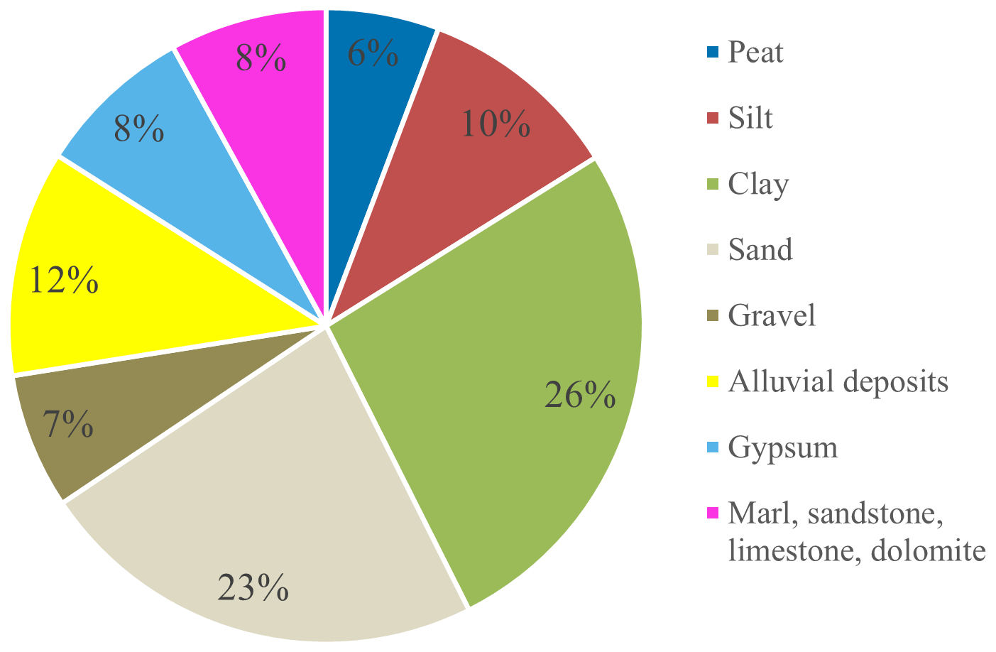
The analysis of the scientific literature, expert sessions, and surveys reveals that 41 (84 %) of the investigated cases are characterized by a geology predominantly composed of soils, while the remaining 8 (16 %) are characterized by geology primarily composed of rocks (Fig. 3). Among the soil types, clay and sand are the most frequent, representing 13 (26 %) and 12 (23 %) of the cases, respectively. A single dominant lithology is observed in 30 (61 %) of the 49 cases, whereas the remaining 19 (39 %) exhibit a more complex geological structure with multiple lithologies.
As for the subsidence reduction measures adopted in the investigated cases, Fig. 4 shows that in 25 cases (51 %) the interventions are related to (ground)water management, followed by construction improvements in 19 cases (39 %) and soil improvements in 5 cases (10 %). The most frequently employed measures are “retention pond” (8 cases) and “aquifer recharge” (7 cases).
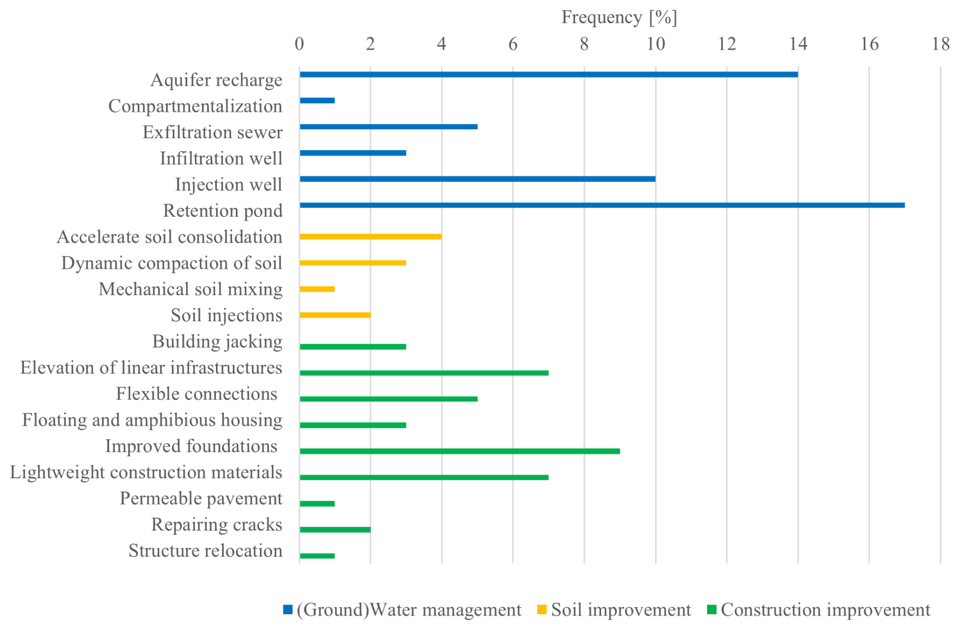
Figure 4Frequency distribution of the subsidence reduction measures in the investigated cases.
Moreover, only 23 (47 %) of the cases employ a single subsidence countermeasure; instead, 26 (53 %) use a combination of measures (see also Table 1). Figure 5 shows a network graph where each node represents a subsidence countermeasure and each link between two nodes indicates at least one case in which the two measures were used together. The subsidence countermeasure with the highest number of connections (11 links) is “improved foundations”. Notably, “mechanical soil mixing” was used exclusively in combination with “accelerate soil consolidation”.
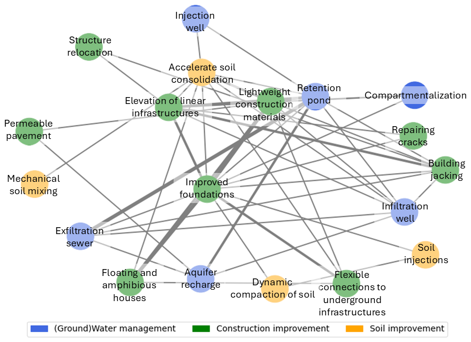
Figure 5Network graph illustrating the connections among subsidence reduction measures used in the investigated cases. Each node represents a distinct countermeasure, while the connections between nodes indicate that two corresponding measures were implemented together in at least one of the investigated cases. The connection weight represents the number of times a connection is present in the case studies.
5.1 Applicability of subsidence reduction measures
The question-and-response (Q&R) system introduced in Sect. 4.1 was applied to evaluate the applicability of the subsidence reduction measures employed in the 49 investigated case studies (see Table B1 in Appendix B). Figure 6 illustrates the results per subsidence countermeasure derived from the literature review, expert sessions, and surveys. This figure can be used to identify suitable subsidence reduction measures for a specific case by disregarding those that do not meet the requirements, which can be done by checking the categories in the columns. Alternatively, the graph can be used to evaluate the applicability of existing subsidence countermeasures by reading it horizontally along the rows. A square marker indicates that a subsidence reduction measure belongs to a specific category or that a category includes a particular measure. When a subsidence reduction measure does not belong to a category, no markers are shown.
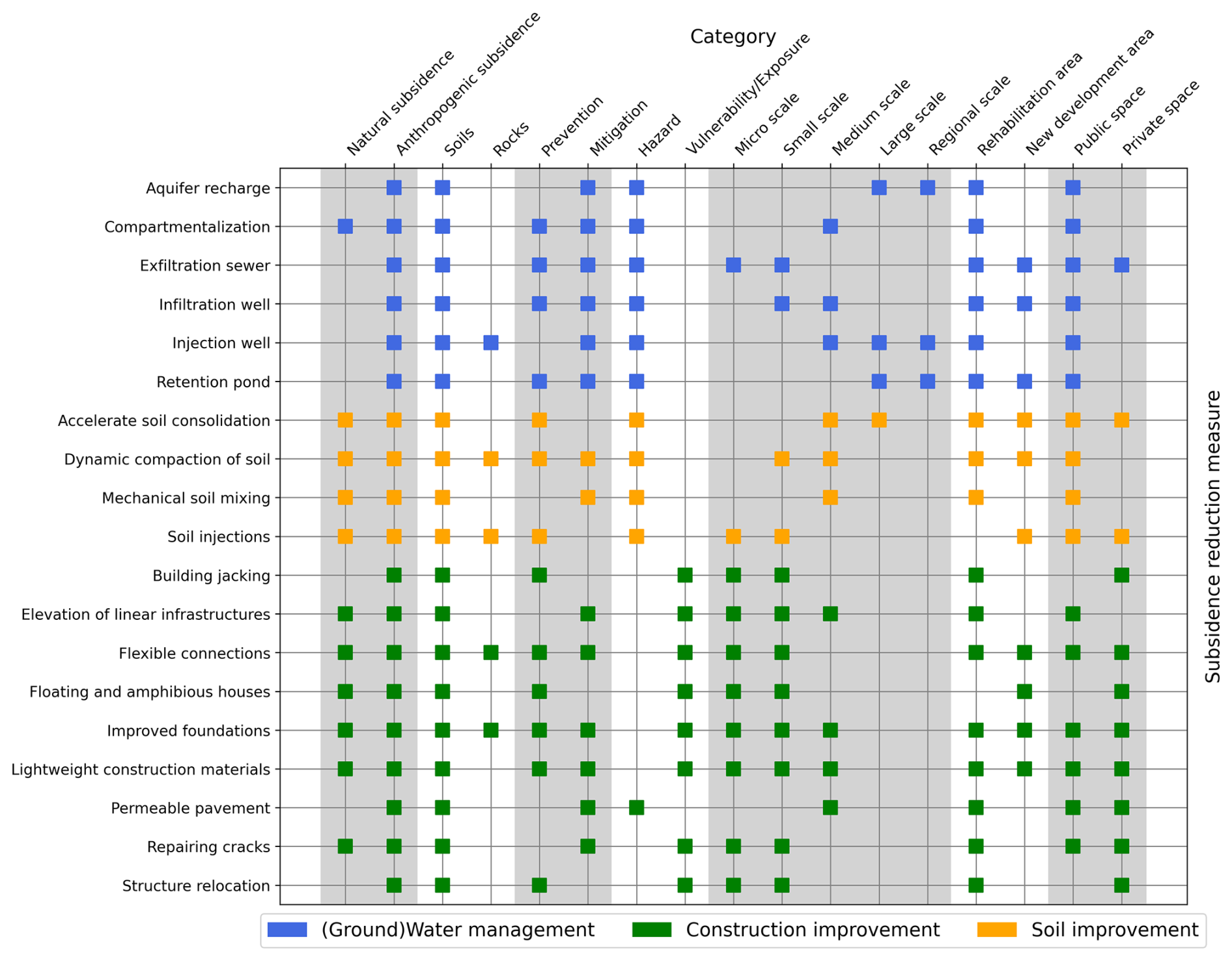
Figure 6Subsidence reduction measures categorized according to the question-and-response (Q&R) system. The squares indicate the association between a measure and a category. The vertical grey shades highlight different groups of categories. Refer to Table B1 in Appendix B for a detailed version.
5.2 Effectiveness of subsidence reduction measures
The four indicators presented in Sect. 4.2 – reduction potential (RP), operational reliability (OR), negative impact (NI), and service life (SL) – were applied to evaluate the effectiveness of the subsidence reduction measures adopted in the 49 investigated case studies (see Table B1 in Appendix B). Table 3 summarizes the results per subsidence countermeasure based on the outcomes of the literature review, two expert sessions, and surveys involving a total of 18 participants. The mode is used as a metric to assign a single value to each indicator of effectiveness for the subsidence countermeasures. In cases of equally frequent results, expert judgement is preferred if available; otherwise, the highest value is assigned. It is important to note that for some subsidence reduction measures some indicators are missing due to insufficient information in the consulted sources (see Table B1 in Appendix B). When no data are available, no value is assigned to the corresponding indicator of effectiveness. This limitation should be taken into account when using Table 3, as it may influence the prioritization and selection of subsidence countermeasures.
Table 3Performance of subsidence reduction measures assessed using four indicators of effectiveness: reduction potential, operational reliability, negative impact, and service life. This is a concise version of Table B1 in Appendix B.
5.3 Selection of subsidence countermeasures based on applicability and effectiveness
This section demonstrates the application of the proposed procedure to three well-documented case studies to simulate its use in real-life scenarios.
5.3.1 Shanghai (China)
First reports of subsidence in Shanghai (China) due to groundwater extraction date back to 1921, with an average rate of 2.6 cm yr−1 (Erkens and Stouthamer, 2020; Yang et al., 2020; Ye et al., 2016). The extraction of groundwater for both domestic and industrial use peaked in the 1950s, accelerating subsidence up to 17 cm yr−1 (Gambolati and Teatini, 2021). To contrast the spread of subsidence, restrictions on groundwater extraction were established in the 1960s (Han, 2003; Huang et al., 2015; Shi et al., 2016; Wu et al., 2020). During the same period, a network of extensometers, benchmarks, and groundwater observation wells was installed to monitor subsidence (Erkens and Stouthamer, 2020; Ye et al., 2016).
In this context, subsidence countermeasures are necessary to mitigate subsidence in the predominantly clayey urban and peri-urban areas of Shanghai, which extend for more than 90 000 km2 (Ye et al., 2016). Based on their applicability (see Sect. 5.1), three options are suitable: aquifer recharge (surface and trenches), injection well, and retention pond. Considering their effectiveness (see Sect. 5.2), the two subsidence countermeasures to be preferred are aquifer recharge (surface and trenches) and injection well.
The literature indicates that aquifer recharge from the surface was considered unfeasible due to higher costs (Shi et al., 2016). Instead, injection wells were preferred for recharging deep aquifers given the topography and land use of the city (Han, 2003; Huang et al., 2015; Shi et al., 2016; Wu et al., 2020). Nowadays, the monitoring network closely controls the rate of subsidence in Shanghai, maintaining it below 0.6 cm yr−1 (Yang et al., 2020). If subsidence exceeds 0.6 cm yr−1, the amount of injected water is adjusted and additional countermeasures are implemented as necessary (Erkens and Stouthamer, 2020). The quality of the injected water is also closely monitored to minimize pollution and prevent the clogging of pores (Shi et al., 2016).
It can be concluded that the subsidence countermeasure employed in Shanghai in real life aligns with the results of the proposed approach. The final selection of injection wells over aquifer recharge from the surface primarily depends on cost considerations and more site-specific evaluations that are not part of the current approach.
5.3.2 Jakarta (Indonesia)
Subsidence was first observed in Jakarta (Indonesia) during Dutch colonization in 1925–1926, although little is known about the sinking rates measured at the time (Abidin et al., 2005). In Jakarta, subsidence was slow to be acknowledged as a potential disaster. Investigations were discontinued until 1978, when the impacts of subsidence became evident as cracking of (infra)structures, malfunctioning drainage systems, increased seawater intrusion, and expansion of the flood-prone area (Abidin et al., 2011; Andreas et al., 2018; Erkens and Stouthamer, 2020). Additionally, the excessive extraction of groundwater caused the water table to drop significantly, limiting access to clean potable water (Abidin et al., 2011; Andreas et al., 2018). The first levelling measurements indicated an average subsidence rate of 6 cm yr−1 between 1991 and 1997, with peaks of 25 cm yr−1 in some locations (Abidin et al., 2005, 2011). Over this 6-year period, cumulative subsidence reached up to 160 cm, particularly in the coastal areas (Abidin et al., 2005, 2011). Continuous groundwater extraction, extensive urbanization, and the presence of relatively young alluvial soils have since increased subsidence rates, with a current velocity of 11–12 cm yr−1 in the most affected areas of Jakarta (Abidin et al., 2015). Only after a severe flood in 2007 that submerged 40 % of the city did local authorities and governments recognize the severity of the problem and begin seeking solutions to mitigate and prevent subsidence and damage to structures (Bucx et al., 2015; Erkens et al., 2015).
In this context, a wider range of subsidence countermeasures is applicable to mitigate and prevent (i) subsidence in the inhabited area of Jakarta, which spans approximately 660 km2, and (ii) damage to (infra)structures at the neighbourhood level (Abidin et al., 2011). At a large scale, measures to mitigate subsidence include aquifer recharge (surface and trenches), injection well, and retention pond, while retention pond and accelerate soil consolidation are suitable to preventing subsidence (see Sect. 5.1). At a small scale, measures to mitigate damage to (infra)structures include elevation of linear infrastructures, flexible connections, improved foundations, lightweight construction materials, and the repairing of cracks, while building jacking, flexible connections, improved foundations, lightweight construction materials, and structure relocation are suitable to prevent damage (see Sect. 5.1). Based on their effectiveness (see Sect. 5.2), aquifer recharge (surface and trenches), accelerate soil consolidation, and injection well should be prioritized to contrast subsidence at a large scale. At a small scale, improved foundations, structure relocation, and elevation of linear infrastructures should be prioritized to reduce damage to (infra)structures.
According to the literature, regulations on groundwater extraction have been introduced to contrast subsidence in Jakarta; instead, building jacking and elevation of linear infrastructures with sand fill have been extensively adopted to prevent and mitigate damage to (infra)structures (Akbar et al., 2019; Andreas et al., 2018; Saputra et al., 2017, 2019). Additional countermeasures, such as aquifer recharge, injection wells, and exfiltration sewers, have been proposed in recent years to tackle the water crisis and mitigate subsidence but have not yet been implemented (Abidin et al., 2015; Akbar et al., 2019; Pramono, 2021). In parallel, retention ponds have been constructed to manage rainwater runoff and reduce flooding in the sub-district of Kebon Jeruk, and deep foundations are increasingly in use in new development areas to prevent damage. However, subsidence in Jakarta is so severe that local governments decided to relocate a consistent portion of the city (Herrera-García et al., 2021).
Compared to Shanghai, the case of Jakarta is more complex. Groundwater serves as the primary source of potable water, but its excessive extraction accelerates the natural subsidence of alluvial soils, rendering the city more vulnerable to flooding and seawater intrusion. These factors, in turn, compromise the availability and quality of freshwater. As a result, local governments are seeking solutions to address multiple interconnected issues: subsidence, flood risk, freshwater scarcity, and deteriorating water quality. This complexity requires a broader set of options, which extends beyond the scope of this study. Instead, the proposed approach focuses strictly on subsidence reduction and does not account for other related issues. Therefore, while retention ponds are not considered suitable for reducing subsidence in Jakarta within this framework, they may still be viable for addressing other challenges. Similarly, building jacking may be more effective in managing flood risk than contrasting damage to (infra)structures caused by subsidence in Jakarta. Nevertheless, the subsidence countermeasures employed in Jakarta overall align with the results of the proposed approach.
5.3.3 San Joaquin Valley (USA, California)
Subsidence in the San Joaquin Valley (USA, California) due to groundwater extraction for agriculture has been observed since the 1920s (Galloway and Riley, 1999). Continuous exploitation of deep confined aquifers and the consequent soil compaction caused an area larger than 10 000 km2 to sink by an average of 31 cm between 1925 and 1970 (Galloway and Riley, 1999). In some localized areas, subsidence reached up to 8.53 m during the same period. In the 1960s, an extensive monitoring network composed of 31 extensometers was implemented to measure soil compaction rates and determine the extent of subsidence (Poland, 1984; USGS, 2024). Since the 1970s, alternative surface water, such as the California Aqueduct and other canals, has been supplied, allowing for a gradual reduction in groundwater extraction. However, recurring droughts in 1976–1977, 1986–1992, 2007–2009, and 2012–2015 drastically reduced surface water availability, leading to a renewed increase in groundwater extraction and aquifer compaction (Galloway and Riley, 1999; USGS, 2024). Between 2006 and 2022, subsidence was estimated to have reached 13 km3, with rates as high as 0.84 km3 yr−1 during droughts and periods of intense groundwater extraction (USGS, 2024).
Based on their applicability (see Sect. 5.1), suitable measures to mitigate subsidence at the regional scale in this soil-dominant area, primarily composed of alluvial deposits, include aquifer recharge (surface and trenches), injection well, and retention pond. Considering their effectiveness (see Sect. 5.2), this selection can be narrowed down to aquifer recharge (surface and trenches) and injection well.
The Sustainable Groundwater Management Act (SGMA) – legislation passed in 2014 – represents a significant step towards sustainable water management in the San Joaquin Valley, aiming to contrast groundwater depletion, aquifer compaction, and the impacts of droughts (Lees et al., 2021). Recently, initiatives have been launched to replenish groundwater by recharging shallow aquifers through surface water percolation, thus helping to balance extraction with natural recharge rates (Lees et al., 2021). Among these initiatives, one key strategy is flood-managed aquifer recharge (Flood-MAR), which combines shallow and deep aquifer management with management of extreme weather events like floods and droughts to preserve agricultural land and minimize damage to infrastructure (Flood-MAR, 2024). Additionally, promoting sustainable water use practices in agriculture and urban areas has become a priority to minimize wastage (USGS, 2024).
Similarly to the previous cases, the subsidence countermeasure employed in the San Joaquin Valley aligns with the results of this study. In this case, aquifer recharge (surface and trenches) was preferred over injection wells because it can handle larger volumes of water (approximately 220×109 gallons (8.33×10⁸ m3) of water are needed annually), it can be integrated with natural systems (e.g. river and trenches), it does not need large infrastructural works, and it is more environmentally sustainable. This case further underlines the importance of conducting detailed assessments of the suitability of subsidence reduction measures to also address changing climates and promote sustainable solutions.
In the previous section, a review of 49 cases distributed in 18 countries gathered from scientific papers, technical articles, expert sessions, and surveys was conducted to formulate a twofold strategy to select subsidence reduction measures in urban areas based on their applicability and performance. The proposed method consists of two steps: the question-and-response (Q&R) system for identifying measures tailored to the specific requirements of each case and the indicators of effectiveness for evaluating the performance of subsidence countermeasures.
The Q&R system proved useful for an initial screening of subsidence reduction measures. Seven questions were determined to categorize the subsidence countermeasures based on the area's geology, cause of subsidence, scale of application, objective of the intervention, and type of urban area. With this system, stakeholders and decision-makers can determine the applicability of measures to specific cases and focus on a more limited number of choices. Each subsidence reduction measure can satisfy the requirements of multiple categories, which can be combined to create tailored decision trees. The proposed Q&R system could be further refined by adding sub-categories accounting for construction and maintenance costs, hydrogeology, geotechnology, and structural engineering. Also, the current Q&R system disregards the indirect effects of subsidence (e.g. the increased risk of flooding or seawater intrusion). In a more comprehensive risk management framework, where subsidence is not the only threat, the Q&R system should be improved to account for multiple hazards and effects.
The indicators of effectiveness proposed in this paper (i.e. reduction potential, operational reliability, negative impact, and service life) allowed for an initial assessment of the performance of subsidence reduction measures. Using these indicators, stakeholders and decision-makers can rapidly assess the effectiveness of suitable subsidence reduction measures selected via the Q&R system. Further improvements to the proposed method may involve novel indicators, such as inclusiveness (what societal groups are targeted) and responsibility (allocation of risks in public–private partnerships). At this stage, the proposed procedure allows for a qualitative assessment of effectiveness based on the joint evaluation of each indicator's performance. The evaluation of performance in Table 3 needs further refinement by considering a broader and well-documented range of cases. Currently, the information available to structure the scoring is limited, as demonstrated in Table B1 in Appendix B. This affects the criteria used to assign scores, possibly leading to over- or underestimations of the effectiveness of certain subsidence countermeasures. This limitation should be taken into account when applying the indicators from Table 3, as it may influence the selection of subsidence reduction measures. The lack of comprehensive and consistent data further underlines the need to collect and share experiences for evaluating the performance of subsidence reduction measures to create a more systematic framework. Once a sufficient number of applications is available for each subsidence reduction measure, quantitative estimations and ranking will also be possible. Additionally, more research is needed to determine the acceptable or unacceptable thresholds for the indicators of effectiveness, also considering the positive or negative interaction of subsidence countermeasures with adjacent assets.
The cases of Shanghai (China), Jakarta (Indonesia), and the San Joaquin Valley (USA, California) demonstrate that the proposed two-step procedure to select subsidence countermeasures based on their applicability and effectiveness is promising. In both Shanghai and the San Joaquin Valley, where the primary goal was subsidence mitigation at a regional scale (i.e. > 1000 km2), the Q&R system identified three suitable options, which was narrowed down to two based on the indicators of effectiveness. In both cases, the two most effective countermeasures (i.e. aquifer recharge and injection well) matched the options considered or implemented in practice. The case of Shanghai underlines that, when subsidence countermeasures have similar levels of effectiveness, cost considerations often play a decisive role, especially at larger scales where costs can escalate significantly. In the San Joaquin Valley, the discriminating factors were primarily the volume of recharged water (estimated at approximately 220×109 gallons (8.33×10⁸ m3) annually) and the sustainability of subsidence countermeasures. Both examples emphasize the importance of site-specific considerations and multi-criteria assessments that weigh effectiveness alongside costs and sustainability. In Jakarta, 11 different options were identified by the system based on their applicability to mitigate or prevent subsidence at a large scale (i.e. 10–1000 km2) and damage to (infra)structures at a small scale (i.e. 0.1–1 km2). This broader set of options was then narrowed down to six based on their effectiveness. In this case, five subsidence countermeasures identified by the procedure matched those employed or proposed in practice. Two additional countermeasures (i.e. retention pond and building jacking) that were deemed ineffective by the proposed procedure to contrast subsidence or damage to (infra)structures were implemented in Jakarta. However, these countermeasures were used to manage increased flood risk rather than subsidence.
These findings demonstrate that, besides the necessary refinements to enhance the accuracy of the proposed method in selecting subsidence reduction measures, careful interpretation of the results is essential. This involves considering the wide variety of subsidence reduction measures, the underlying causes of subsidence, site-specific settings, potential negative or secondary effects, and the long-term sustainability of countermeasures. Environmental considerations encompass potential alterations of local ecosystems, changes to water quality, depletion of natural resources, and increased energy consumption with associated carbon emissions. For instance, creating artificial retention ponds may disrupt natural habitats, while recharging aquifers – whether through surface or deep injections – may affect water quality. Similarly, infrastructure-heavy solutions, such as injection wells, can contribute to greenhouse gas emissions, especially if they rely on non-renewable energy sources. Social impacts involve the displacement of communities due to relocation, leading to social stress and loss of community identity. Equity issues can also arise, as the increased costs or reduced availability of potable water disproportionately affect low-income populations. Other economic implications include rising property values, which can lead to gentrification and displacement of lower-income residents. Given these challenges, stakeholders and decision-makers should adopt a multidimensional approach to subsidence (risk) management that integrates technical considerations with environmental stewardship, social equity, and economic feasibility. Proactively addressing the indirect consequences of subsidence reduction measures can contribute to sustainable and resilient urban development. Additionally, in settings with compound hazards, such as Jakarta, broader contextual analyses are necessary to fully understand the applicability and effectiveness of specific countermeasures. For a thorough validation of the proposed method, a detailed evaluation of effectiveness via measurable parameters – such as water table levels, water infiltration rates, the volume of extracted or recharged water, soil compaction, surface rebound, settlement rates, and crack widths – is crucial. It is rather surprising how few cases are reported in the literature, with even fewer with a sufficient evaluation of effectiveness. The consistent use of the four indicators of effectiveness specifically derived for evaluating the subsidence countermeasures presented in this paper can serve as the basis and catalyst for this.
Subsidence is a relatively slow process with moderate intensity that is rarely perceived as an imminent disaster. However, its physical, socio-economic, and environmental impacts in urban areas require tailored reduction policies encompassing both mitigation and prevention strategies.
After defining key terminology (i.e. reduction, mitigation, prevention, adaptation, and structural and non-structural measures), this paper proposed a twofold strategy for selecting structural (i.e. technical) measures to contrast subsidence and its physical consequences in urban areas based on their applicability and effectiveness. The objective is to assist stakeholders and decision-makers in managing subsidence (risk) in urban areas, with particular attention to the planning and implementation phases of the subsidence risk frameworks.
Despite the preliminary nature of this work, the proposed methods for selecting subsidence reduction measures and evaluating their effectiveness constitute a novelty in the scientific literature on subsidence studies and mitigation/prevention strategies as no framework currently exists to assess applicable and effective measures. Refinements and further validation are needed to integrate the procedure into current subsidence management practices in urban areas, with specific attention paid to the local hydrogeological, geotechnical, structural, environmental, and social settings where countermeasures are needed. Therefore, at its current stage, the methodology proposed in this paper should be considered a preliminary tool for stakeholders and decision-makers to identify a set of suitable solutions, which should be further discussed with local experts. Moreover, with appropriate adjustments, the presented methodologies could also be applied for selecting and evaluating the performance of non-structural (i.e. non-technical) measures, subsidence reduction measures in rural areas, and secondary subsidence effects.
Table A1 provides a brief description and alternative names of structural (i.e. technical) measures considered in this paper to prevent and mitigate (i.e. reduce) subsidence and its physical consequences in urban areas. The countermeasures in Table A1 are organized into (ground)water management, soil interventions, and construction interventions.
Table A1Structural (i.e. technical) measures to reduce subsidence and its physical consequences in urban areas.
Table B1 reports the assessment of applicability (see Sect. 4.1) and effectiveness (see Sect. 4.2) of the subsidence reduction measures adopted in the 49 cases investigated in this paper.
Table B1Assessment of the applicability and effectiveness of subsidence reduction measures employed in the 49 investigated cases derived from the literature review, expert sessions, and surveys. The applicability results are from the question-and-response (Q&R) decision tree system. Effectiveness is evaluated using the indicators of reduction potential (RP), operational reliability (OR), negative impact (NI), and service life (SL). NA denotes information that is “not available”.
The data used in this study were compiled from sources including publicly available literature, surveys, and expert sessions. While the literature is accessible to most readers, the aggregated dataset generated for this study is not publicly available.
NN and MK conceptualized the research. NN collected and analysed the data, designed the methodology, and prepared the draft and edited version of the manuscript. MK reviewed the manuscript and supervised the activities involved in the research.
The contact author has declared that neither of the authors has any competing interests.
Publisher's note: Copernicus Publications remains neutral with regard to jurisdictional claims made in the text, published maps, institutional affiliations, or any other geographical representation in this paper. While Copernicus Publications makes every effort to include appropriate place names, the final responsibility lies with the authors.
The research presented in this article is part of the project Living on Soft Soils: Subsidence and Society (grant no. NWA.1160.18.259), which is funded by the Dutch Research Council (NWO-NWA-ORC), Utrecht University, Wageningen University & Research, the Delft University of Technology, the Ministry of Infrastructure and Water Management, the Ministry of the Interior and Kingdom Relations, Deltares, Wageningen Environmental Research, the Geological Survey of the Netherlands (TNO), the Foundation for Applied Water Research (STOWA), the Hoogheemraadschap de Stichtse Rijnlanden water authority, the Drents Overijsselse Delta water authority, the Province of Utrecht, the Province of South Holland, the Municipality of Gouda, Platform Soft Soil, Sweco, TAUW bv, and NAM.
This research has been supported by the Nederlandse Organisatie voor Wetenschappelijk Onderzoek (grant no. NWA.1160.18.259).
This paper was edited by Paolo Tarolli and reviewed by Samar Momin and one anonymous referee.
Abidin, H. Z., Andreas, H., Gamal, M., Djaja, R., Subarya, C., Hirose, K., Maruyama, Y., Murdohardono, D., and Rajiyowiryono, H.: Monitoring Land Subsidence of Jakarta (Indonesia) Using Leveling, GPS Survey and InSAR Techniques, in: A Window on the Future of Geodesy, edited by: Sansò, F., International Association of Geodesy Symposia, Sapporo, Japan, 30 June–11 July 2003, Springer, Berlin, Heidelberg, vol. 128, https://doi.org/10.1007/3-540-27432-4_95, 2005.
Abidin, H. Z., Andreas, H., Gumilar, I., Fukuda, Y., Pohan, Y. E., and Deguchi, T.: Land subsidence of Jakarta (Indonesia) and its relation with urban development, Nat. Hazards, 59, 1753–1771, https://doi.org/10.1007/s11069-011-9866-9, 2011.
Abidin, H. Z., Andreas, H., Gumilar, I., and Brinkman, J. J.: Study on the risk and impacts of land subsidence in Jakarta, Proc. IAHS, 372, 115–120, https://doi.org/10.5194/piahs-372-115-2015, 2015.
Akbar, I., Poerbo, H. W., and Soedarsono, W. K.: Adaptive Urban Design Principles for Land Subsidence and Sea Level Rise in Coastal Area of Tambak Lorok, Semarang, IOP Conf. Ser. Earth Environ. Sci., 273, 012005, https://doi.org/10.1088/1755-1315/273/1/012005, 2019.
Alferink, F. and Cordóva, H. G.: Consideration on Design and Choice of Modern Pipelines for Use in Earthquake Areas, Civil Engineering and Architecture, 5, 94–103, https://doi.org/10.13189/cea.2017.050304, 2017.
Al-Zabedy, S. and Al-Kifae, A.: Controlling collapsibility potential by improving Iraqi gypseous soils subsidence: A Review study, IOP Conf. Ser. Mater. Sci. Eng., 745, 012107, https://doi.org/10.1088/1757-899X/745/1/012107, 2020.
Andreas, H., Zainal Abidin, H., Pradipta, D., Anggreni Sarsito, D., and Gumilar, I.: Insight look the subsidence impact to infrastructures in Jakarta and Semarang area; Key for adaptation and mitigation, MATEC Web Conf., 147, 08001, https://doi.org/10.1051/MATECCONF/201814708001, 2018.
Andriani, A., Novasari, H., Syukur, M., and Hadie, M. S. N.: Spatial model of land subsidence mitigation at lowland areas, E3S Web Conf., 331, 1–5, https://doi.org/10.1051/e3sconf/202133103008, 2021.
Bagheri-Gavkosh, M., Hosseini, S. M., Ataie-Ashtiani, B., Sohani, Y., Ebrahimian, H., Morovat, F., and Ashrafi, S.: Land subsidence: A global challenge, Sci. Total Environ., 778, 146193, https://doi.org/10.1016/j.scitotenv.2021.146193, 2021.
Basak, O. and Chowdhury, S. A.: Flood Resilient Amphibious Housing: Barriers and Prospects, Proceedings of International Conference on Planning, Architecture and Civil Engineering, 9–11 September 2021, Rajshahi University of Engineering and Technology, Rajshahi, Bangladesh, https://www.researchgate.net/publication/354507357_Flood_Resilient_Amphibious_Housing_Barriers_and_Prospects (last access: 29 May 2025), 2021.
Bell, J. W., Amelung, F., Ramelli, A. R., and Blewitt, G.: Land Subsidence in Las Vegas, Nevada, 1935–2000: New Geodetic Data Show Evolution, Revised Spatial Patterns, and Reduced Rates, Environ. Eng. Geosci., 8, 155–174, 2002.
Bergado, D. T., Alfaro, M. C., and Balasubramaniam, A. S.: Improvement of soft Bangkok clay using vertical drains, Geotext. Geomembranes, 12, 615–663, https://doi.org/10.1016/0266-1144(93)90032-J, 1993.
Brighenti, G.: Land subsidence due to thermal water withdrawal: the case of Abano Terme, Northern Italy, in: Proceedings of the Fourth International Symposium on Land Subsidence, 12–17 May 1991, Houston, Texas, USA, IAHS Publ. no. 200, https://www.landsubsidence-unesco.org/wp-content/uploads/2019/03/Proceedings_Houston_1991.pdf (last access: 29 May 2025), 1991.
Bründl, M., Baumann, R., Burkard, A., Dolf, F., Gauderon, A., Gertsch, E., Gutwein, P., Krummenacher, B., Loup, B., Schertenleib, A., Oggier, N., Zaugg-Ettlin, L.: Evaluating the Effectiveness and the Efficiency of Mitigation Measures against Natural Hazards, Interpraevent, Lucerne, Switzerland, 27–33, https://www.researchgate.net/publication/303769487_Evaluating_the_Effectiveness_and_the_Efficiency_of_Mitigation_Measures_against_Natural_Hazards (last access: 29 May 2025), 2016.
Bucx, T. H. M., van Ruiten, C. J. M., Erkens, G., and de Lange, G.: An integrated assessment framework for land subsidence in delta cities, Proc. IAHS, 372, 485–491, https://doi.org/10.5194/piahs-372-485-2015, 2015.
Carreón-Freyre, D., Cerca, M., Gutiérrez Calderón, R., and Huerta Ladrón De Guevara, M.: Monitoring of land subsidence and fracturing in Iztapalapa, Mexico City, IAHS Publ., 339, 17–22, 2010.
Davydzenka, T., Tahmasebi, P., and Shokri, N.: Data for “Unveiling the Global Extent of Land Subsidence: The sinking crisis”, Zenodo [data set], https://doi.org/10.5281/zenodo.10223637, 2023.
Deakin, N.: Repair of subsidence damage: An insurer's perspective, Journal of Building Appraisal, 1, 225–243, https://doi.org/10.1057/palgrave.jba.2940020, 2005.
Department of Regional NSW: Guide – Managing risks of subsidence, WHS (Mines and Petroleum Sites) Legislation, https://www.resources.nsw.gov.au/sites/default/files/documents/guideline-managing-risks-of-subsidence-guideline.pdf (last access: 29 May 2025), 2023.
Dinar, A., Esteban, E., Calvo, E., Herrera, G., Teatini, P., Tomás, R., Li, Y., Ezquerro, P., and Albiac, J.: We lose ground: Global assessment of land subsidence impact extent, Sci. Total Environ., 786, 147415, https://doi.org/10.1016/j.scitotenv.2021.147415, 2021.
English, E., Klink, N., and Turner, S.: Thriving with water: Developments in amphibious architecture in North America, FLOODrisk 2016 – 3rd European Conference on Flood Risk Management (FLOODrisk 2016), 17–21 October 2016, Lyon, France, E3S Web Conf., 7, 13009, https://doi.org/10.1051/e3sconf/20160713009, 2016.
English, E. C., Chen, M., Zarins, R., Patange, P., and Wiser, J. C.: Building Resilience through Flood Risk Reduction: The Benefits of Amphibious Foundation Retrofits to Heritage Structures, Int. J. Archit. Herit., 15, 976–984, https://doi.org/10.1080/15583058.2019.1695154, 2021.
Erkens, G. and Stouthamer, E.: The 6M approach to land subsidence, Proc. IAHS, 382, 733–740, https://doi.org/10.5194/piahs-382-733-2020, 2020.
Erkens, G., Bucx, T., Dam, R., de Lange, G., and Lambert, J.: Sinking coastal cities, Proc. IAHS, 372, 189–198, https://doi.org/10.5194/piahs-372-189-2015, 2015.
Ezquerro, P., Soldato, M. Del, Solari, L., Tomás, R., Raspini, F., Ceccatelli, M., Fernández-Merodo, J. A., Casagli, N., and Herrera, G.: Vulnerability Assessment of Buildings due to Land Subsidence using InSAR Data in the Ancient Historical City of Pistoia (Italy), Sensors, 20, 2749, https://doi.org/10.3390/s20102749, 2020.
Flood-MAR Hub (Flood-MAR): https://floodmar.org/, last access: 30 November 2024.
Galloway, D. and Riley, F. S.: San Joaquin Valley: California Largest Human Alteration of the Earth's Surface, Land Subsidence in the United States, U.S. Geological Survey Circular, 1182, 23–34, https://www.researchgate.net/publication/313157507_San_Joaquin_Valley_California_Largest_human_alteration_of_the_Earth's_surface (last access: 29 May 2025), 1999.
Galloway, D. L. and Burbey, T. J.: Review: Regional land subsidence accompanying groundwater extraction, Hydrogeol. J., 19, 1459–1486, https://doi.org/10.1007/s10040-011-0775-5, 2011.
Gambolati, G. and Teatini, P.: Land Subsidence and its Mitigation, The Groundwater Project, Guelph, Ontario, Canada, ISBN 978-1-77470-001-3, https://doi.org/10.21083/978-1-77470-001-3, 2021.
Gambolati, G., Teatini, P., and Ferronato, M.: Anthropogenic Land Subsidence, in: Encyclopedia of Hydrological Sciences, John Wiley & Sons, Ltd, https://doi.org/10.1002/0470848944.hsa164b, 2005.
Gutiérrez, F. and Cooper, A. H.: Evaporite Dissolution Subsidence in the Historical City of Calatayud, Spain: Damage Appraisal and Prevention, Nat. Hazards, 25, 259–288, 2002.
Hamidi, B., Nikraz, H., and Varaksin, S.: Dynamic Compaction for Treating Millions of Square Meters of Sand, International Conference on Advances in Geotechnical Engineering, Perth, Australia, 7–9 November 2011, ISBN 978-0-646-55142-5, https://espace.curtin.edu.au/bitstream/handle/20.500.11937/8479/168859_42270_63705.pdf?sequence=2&isAllowed=y (last access: 29 May 2025), 2011.
Han, Z.: Groundwater resources protection and aquifer recovery in China, Environ. Geol., 44, 106–111, https://doi.org/10.1007/s00254-002-0705-x, 2003.
Herrera, G., Tomás, R., Monells, D., Centolanza, G., Mallorquí, J. J., Vicente, F., Navarro, V. D., Lopez-Sanchez, J. M., Sanabria, M., Cano, M., and Mulas, J.: Analysis of subsidence using TerraSAR-X data: Murcia case study, Eng. Geol., 116, 284–295, https://doi.org/10.1016/j.enggeo.2010.09.010, 2010.
Herrera-García, G., Ezquerro, P., Tomas, R., Béjar-Pizarro, M., López-Vinielles, J., Rossi, M., Mateos, R. M., Carreón-Freyre, D., Lambert, J., Teatini, P., Cabral-Cano, E., Erkens, G., Galloway, D., Hung, W. C., Kakar, N., Sneed, M., Tosi, L., Wang, H., and Ye, S.: Mapping the global threat of land subsidence, Science, 371, 34–36, https://doi.org/10.1126/science.abb8549, 2021.
Huang, Y., Yang, Y., and Li, J.: Numerical simulation of artificial groundwater recharge for controlling land subsidence, KSCE J. Civ. Eng., 19, 418–426, https://doi.org/10.1007/s12205-015-0505-y, 2015.
Hudson, P., Botzen, W. J. W., Kreibich, H., Bubeck, P., and Aerts, J. C. J. H.: Evaluating the effectiveness of flood damage mitigation measures by the application of propensity score matching, Nat. Hazards Earth Syst. Sci., 14, 1731–1747, https://doi.org/10.5194/nhess-14-1731-2014, 2014.
Hutabarat, L. E. and Ilyas, T.: Mapping of land subsidence induced by groundwater extraction in urban areas as basic data for sustainability countermeasures, International Journal of Technology, 8, 1001–1011, https://doi.org/10.14716/ijtech.v8i6.754, 2017.
Ikuemonisan, F. E., Ozebo, V. C., and Olatinsu, O. B.: Investigation of Sentinel-1-derived land subsidence using wavelet tools and triple exponential smoothing algorithm in Lagos, Nigeria, Environ. Earth Sci., 80, 1–17, https://doi.org/10.1007/s12665-021-10020-1, 2021.
Januriyadi, N. F., Kazama, S., Moe, I. R., and Kure, S.: Effectiveness of Structural and Nonstructural Measures on the Magnitude and Uncertainty of Future Flood Risks, J. Water Resour. Prot., 12, 401–415, https://doi.org/10.4236/jwarp.2020.125024, 2020.
Jha, M. K., Kamii, Y., and Chikamori, K.: Cost-effective approaches for sustainable groundwater management in alluvial aquifer systems, Water Resour. Manag., 23, 219–233, https://doi.org/10.1007/s11269-008-9272-6, 2009.
Jin, B., Zeng, T., Wang, T., Zhang, Z., Gui, L., Yin, K., and Zhao, B.: Advanced risk assessment framework for land subsidence impacts on transmission towers in Salt Lake region, Environ. Model. Softw., 177, 106058, https://doi.org/10.1016/j.envsoft.2024.106058, 2024.
Kohlnhofer, G.: Lightweight Fill Materials for Road Construction, Sixth International Conference on Low Volume Roads, Minneapolis, Minnesota, USA, 25–29 June 1995, 139–148, http://onlinepubs.trb.org/Onlinepubs/conf/1995/cp6/v2/cp6v2.pdf (last access: 29 May 2025), 1995.
Kok, S. and Costa, A. L.: Framework for economic cost assessment of land subsidence, Nat. Hazards, 106, 1931–1949, https://doi.org/10.1007/s11069-021-04520-3, 2021.
Kok, S. and Hommes-Slag, S.: Cost-benefit analysis of urban subsidence mitigation strategies in Gouda, the Netherlands, Proc. IAHS, 382, 761–766, https://doi.org/10.5194/piahs-382-761-2020, 2020.
Lees, M., Knight, R., Smith, R.: Modeling 65 Years of Land Subsidence in California's San Joaquin Valley, PREPRINT (Version 1), Research Square, https://doi.org/10.21203/rs.3.rs-609832/v1, 2021.
Li, M. G., Chen, J. J., Xu, Y. S., Tong, D. G., Cao, W. W., and Shi, Y. J.: Effects of groundwater exploitation and recharge on land subsidence and infrastructure settlement patterns in Shanghai, Eng. Geol., 282, 105995, https://doi.org/10.1016/j.enggeo.2021.105995, 2021.
Liang, R., Xu, S., and Edil, T.: Innovative soft soil improvement method through intelligent use of vacuum de-watering and dynamic compaction techniques, Geotechnical Engineering, 46, 57–67, 2015.
Lixin, Y., Yanxiang, J., Yajie, Z., Lixin, D., Jing, K., Jie, Y., and Yongpeng, Y.: Generating strategies for land subsidence control and remediation based on risk classification evaluation in Tianjin, China, Nat. Hazards, 114, 733–749, https://doi.org/10.1007/s11069-022-05410-y, 2022.
López-Quiroz, P., Doin, M. P., Tupin, F., Briole, P., and Nicolas, J. M.: Time series analysis of Mexico City subsidence constrained by radar interferometry, J. Appl. Geophy., 69, 1–15, https://doi.org/10.1016/j.jappgeo.2009.02.006, 2009.
Luo, Y., Yang, J., and Jiang, H.: Techniques for Assessing and Mitigating Longwall Subsidence Effects on Interstate Highways, Min. Metall. Explor., 36, 1157–1167, https://doi.org/10.1007/s42461-019-0087-1, 2019.
Margreth, S. and Romang, H.: Effectiveness of mitigation measures against natural hazards, Cold Reg. Sci. Technol., 64, 199–207, https://doi.org/10.1016/j.coldregions.2010.04.013, 2010.
McBean, E., Huang, G., Yang, A., Cheng, H., Wu, Y., Liu, Z., Dai, Z., Fu, H., and Bhatti, M.: The Effectiveness of Exfiltration Technology to Support Sponge City Objectives, Water, 11, 723, https://doi.org/10.3390/W11040723, 2019.
Nappo, N., Peduto, D., Polcari, M., Livio, F., Ferrario, M. F., Comerci, V., Stramondo, S., and Michetti, A. M.: Subsidence in Como historic centre (northern Italy): assessment of building vulnerability combining hydrogeological and stratigraphic features, Cosmo-SkyMed InSAR and damage data, Int. J. Disast. Risk Re., 56, 102115, https://doi.org/10.1016/j.ijdrr.2021.102115, 2021.
Nutalaya, P., Yong, R. N., Chumnankit, T., and Buapeng, S.: Land Subsidence in Bangkok during 1978–1988, Springer Nature, the Netherlands, https://doi.org/10.1007/978-94-015-8719-8_6, 1996.
Ovando-Shelley, E., Ossa, A., and Santoyo, E.: Effects of regional subsidence and earthquakes on architectural monuments in MEXICO CITY, B. Soc. Geol. Mex., 65, 157–167, https://doi.org/10.18268/BSGM2013v65n1a12, 2013.
Pacheco-Martínez, J., Hernandez-Marín, M., Burbey, T. J., González-Cervantes, N., Ortíz-Lozano, J. Á., Zermeño-De-Leon, M. E., and Solís-Pinto, A.: Land subsidence and ground failure associated to groundwater exploitation in the Aguascalientes Valley, México, Eng. Geol., 164, 172–186, https://doi.org/10.1016/j.enggeo.2013.06.015, 2013.
Paukstys, B., Cooper, A. H., and Arustiene, J.: Planning for gypsum geohazards in Lithuania and England, Eng. Geol., 52, 93–103, https://doi.org/10.1016/S0013-7952(98)00061-1, 1999.
Pedretti, L., Giarola, A., Korff, M., Lambert, J., and Meisina, C.: Database of subsidence in major coastal cities around the world, Zenodo [data set], https://doi.org/10.5281/zenodo.8410441, 2023.
Pedretti, L., Giarola, A., Korff, M., Lambert, J., and Meisina, C.: A comprehensive database of land subsidence in 143 major coastal cities around the world: an overview of the issues, causes and future challenges, Front. Earth Sci., 12, 1351581, https://doi.org/10.3389/feart.2024.1351581, 2024.
Peduto, D., Cascini, L., Arena, L., Ferlisi, S., Fornaro, G., and Reale, D.: A general framework and related procedures for multiscale analyses of DInSAR data in subsiding urban areas, ISPRS J. Photogramm., 105, 186–210, https://doi.org/10.1016/j.isprsjprs.2015.04.001, 2015.
Peduto, D., Korff, M., Nicodemo, G., Marchese, A., and Ferlisi, S.: Empirical fragility curves for settlement-affected buildings: Analysis of different intensity parameters for seven hundred masonry buildings in The Netherlands, Soils Found., 59, 380–397, https://doi.org/10.1016/j.sandf.2018.12.009, 2019.
Phien-Wej, N., Giao, P. H., and Nutalaya, P.: Field experiment of artificial recharge through a well with reference to land subsidence control, Eng. Geol., 50, 187–201, https://doi.org/10.1016/S0013-7952(98)00016-7, 1998.
Piper, C.: A New Diagrammatic Framework for Illustrating and Explaining Disaster Management, Australian & New Zealand Disaster & Emergency Management Conference Gold Coast, Queensland, Australia, 2–3 September 2021, https://www.preventionweb.net/media/87304/download?startDownload=20250521 (last access: 29 May 2025), 2021.
Poland, J. F.: Guidebook to studies of land subsidence due to ground-water withdrawal, Studies and reports in hydrology, 40, UNESCO, ISBN 92-3-102213-x, https://unesdoc.unesco.org/ark:/48223/pf0000065167 (last access: 29 May 2025), 1984.
Pötz, H. and Bleuzé, P.: Vorm geven aan stedelijk water, SUN architecture, STOWA, report number 2014-12, Amsterdam, the Netherlands, ISBN 978.90.5773.632.2, https://www.stowa.nl/sites/default/files/assets/PUBLICATIES/Publicaties%202014/STOWA%202014-12%20EN.pdf (last access: 29 May 2025), 2009.
Pramono, I. B.: Nature-based solutions for integrating flood and land subsidence: A case study in Jakarta and Semarang, IOP Conf. Ser. Earth Environ. Sci., 874, 012001, https://doi.org/10.1088/1755-1315/874/1/012001, 2021.
Ritzema, H.: Coastal Lowland development: coping with climate change: examples from the Netherlands, International Workshop on Sustainable paddy farming and healthy environment, 29–30 October 2008, Changwon City, Republic of Korea, Proceedings, Korean INWERF Committee and ICID WG-SDTAAt, 1–24, https://www.researchgate.net/publication/37793061_Coastal_Lowland_development_coping_with_climate_change_examples_from_the_Netherlands (last access: 29 May 2025), 2008.
Saputra, E., Hartmann, T., Zoomers, A., and Spit, T.: Fighting the Ignorance: Public Authorities' and Land Users' Responses to Land Subsidence in Indonesia, Am. J. Clim. Change, 6, 1–21, https://doi.org/10.4236/ajcc.2017.61001, 2017.
Saputra, E., Spit, T., and Zoomers, A.: Living in a Bottomless Pit: Households' Responses to Land Subsidence, an Example from Indonesia, J. Environ. Prot. (Irvine, Calif), 10, 1–21, https://doi.org/10.4236/jep.2019.101001, 2019.
Scopus: https://www.scopus.com/, last access: 30 July 2024.
Shen, M., Juang, C. H., and Chen, Q.: Mitigation of liquefaction hazard by dynamic compaction – A random field perspective, Can. Geotech. J., 56, 1803–1815, https://doi.org/10.1139/cgj-2018-0502, 2019.
Shi, X., Jiang, S., Xu, H., Jiang, F., He, Z., and Wu, J.: The effects of artificial recharge of groundwater on controlling land subsidence and its influence on groundwater quality and aquifer energy storage in Shanghai, China, Environ. Earth Sci., 75, 1–18, https://doi.org/10.1007/s12665-015-5019-x, 2016.
Singh, K. B. and Dhar, B. B.: Sinkhole subsidence due to mining, Geotechnical and Geological Engineering, 15, 327–341, https://doi.org/10.1023/A:1018471911108, 1997.
Sneed, M. and Brandt, J. T.: Mitigating Land Subsidence in the Coachella Valley, California, USA: An Emerging Success Story, Proc. IAHS, 382, 809–813, https://doi.org/10.5194/piahs-382-809-2020, 2020.
Stouthamer, E., Erkens, G., Cohen, K., Hegger, D., Driessen, P., Weikard, H. P., Hefting, M., Hanssen, R., Fokker, P., van den Akker, J., Groothuijse, F., and van Rijswick, M.: Dutch national scientific research program on land subsidence: Living on soft soils – subsidence and society, Proc. IAHS, 382, 815–819, https://doi.org/10.5194/piahs-382-815-2020, 2020.
Szucs, P., Madarasz, T., and Civan, F.: Remediating over-produced and contaminated aquifers by artificial recharge from surface waters, Environ. Model. Assess., 14, 511–520, https://doi.org/10.1007/s10666-008-9156-4, 2009.
Tang, W., Zhao, X., Motagh, M., Bi, G., Li, J., Chen, M., Chen, H., and Liao, M.: Land subsidence and rebound in the Taiyuan basin, northern China, in the context of inter-basin water transfer and groundwater management, Remote Sens. Environ., 269, 112792, https://doi.org/10.1016/j.rse.2021.112792, 2022.
Testa, S. M.: Elevation Changes Associated with Groundwater Withdrawal and Reinjection in the Wilmington Area, Los Angeles Coastal Plain, California, in: Proceedings of the Fourth International Symposium on Land Subsidence, 12–17 May 1991, Houston, Texas, USA, IAHS Publ. no. 200, https://www.landsubsidence-unesco.org/wp-content/uploads/2019/03/Proceedings_Houston_1991.pdf (last access: 29 May 2025), 1991.
Ting, C.-S., Chiang, K.-F., Hsieh, S.-H., Tsao, C.-H., Chuang, C.-H., and Fan, K.-T.: Land subsidence and managed aquifer recharge in Pingtung Plain, Taiwan, Proc. IAHS, 382, 843–849, https://doi.org/10.5194/piahs-382-843-2020, 2020.
United Nations: Sendai Framework for Disaster Risk Reduction 2015–2030, Third UN World Conference, 18 March 2015, Sendai, Japan, https://www.preventionweb.net/files/43291_sendaiframeworkfordrren.pdf (last access: 29 May 2025), 2015.
United Nations Office for Disaster Risk Reduction (UNDRR): https://www.undrr.org/terminology/, last access: 30 July 2024.
United Nations Terminology Database (UNTERM): https://unterm.un.org/unterm2/en/, last access: 30 July 2024.
US Geological Survey (USGS): https://www.usgs.gov/centers/land-subsidence-in-california/science/land-subsidence-san-joaquin-valley, last access: 30 July 2024.
Wu, J., Yan, X., Yang, T., and Huang, X.: Research on solute transport characteristics in the process of artificial recharge to control land subsidence in deep confined aquifer, Proc. IAHS, 382, 709–713, https://doi.org/10.5194/piahs-382-709-2020, 2020.
Xuan, D., Xu, J., Wang, B., and Teng, H.: Borehole Investigation of the Effectiveness of Grout Injection Technology on Coal Mine Subsidence Control, Rock Mech. Rock Eng., 48, 2435–2445, https://doi.org/10.1007/s00603-015-0710-5, 2015.
Yang, T., Yan, X., Huang, X., and Wu, J.: Integrated management of groundwater exploitation and recharge in Shanghai based on land subsidence control, Proc. IAHS, 382, 831–836, https://doi.org/10.5194/piahs-382-831-2020, 2020.
Ye, S., Xue, Y., Wu, J., Yan, X., and Yu, J.: Progression and mitigation of land subsidence in China, Hydrogeol. J., 24, 685–693, https://doi.org/10.1007/s10040-015-1356-9, 2016.
Zektser, S., Loáiciga, H. A., and Wolf, J. T.: Environmental impacts of groundwater overdraft: selected case studies in the southwestern United States, Env. Geol., 47, 396–404, https://doi.org/10.1007/s00254-004-1164-3, 2005.
- Abstract
- Introduction
- Definitions
- Data collection
- Method to select subsidence reduction measures
- Application of the proposed approach
- Discussion
- Conclusions
- Appendix A: Description of subsidence reduction measures
- Appendix B: Applicability and effectiveness
- Data availability
- Author contributions
- Competing interests
- Disclaimer
- Acknowledgements
- Financial support
- Review statement
- References