the Creative Commons Attribution 4.0 License.
the Creative Commons Attribution 4.0 License.
 | 15 May 2023
Looking for undocumented earthquake effects: a probabilistic analysis of Italian macroseismic data
Andrea Antonucci
Andrea Rovida
Vera D'Amico
Dario Albarello
A methodology to detect local incompleteness of macroseismic intensity data at the local scale is presented. In particular, the probability that undocumented effects actually occurred at a site is determined by considering intensity prediction equations (in their probabilistic form) integrated by observations relative to known events documented at surrounding sites. The outcomes of this analysis can be used to investigate how representative and known the seismic histories of localities are (i.e., the list of documented effects through time). The proposed approach is applied to the Italian area. The analysis shows that, at most of the considered sites, the effects of intensity ≥ 6 should most probably have occurred at least once, but they are not contained in the current version of the Italian macroseismic databases. In a few cases, instead, the lack of data may concern higher intensity levels (i.e., ≥ 8). The geographical distribution of potentially lost information reflects the heterogeneity of the seismic activity over the Italian territory.
- Article
(4159 KB) - Full-text XML
-
Supplement
(521 KB) - BibTeX
- EndNote


Extending the knowledge of the seismicity of an area as far back as possible in time is essential in seismological research, including seismotectonic investigations and seismic hazard assessment. For these purposes, earthquake catalogues spanning hundreds of years represent an essential complement of instrumental data relative to the last few decades. The compilation of these catalogues relies on the analysis of the effects documented on the human and natural environment during past earthquakes, interpreted and standardized in terms of macroseismic intensity scales (e.g., MCS – Sieberg, 1923; MMI – Wood and Neumann, 1931; MSK – Medvedev et al., 1964; EMS-98 – Grünthal, 1998). Intensity data available at different localities for a given earthquake (intensity data points, hereafter IDPs) can be used to constrain the respective epicentral location and magnitude with a variety of methodological approaches (e.g., in recent years Bakun and Wentworth, 1997; Gasperini et al., 1999, 2010; Provost and Scotti, 2020).
Compared to other regions of the world, the knowledge of European seismicity is particularly detailed and lengthy (Albini et al., 2013; Locati et al., 2014; Rovida et al., 2020a, 2022a), and Italy stands out from other European countries. The bulk of the current Italian Parametric Earthquake Catalogue CPTI15 version 4.0 (Rovida et al., 2020b, 2022b) mostly derives from the harmonization and parametrization of intensity data contained in the Italian Macroseismic Database DBMI15 version 4.0 (Locati et. al., 2022). In fact, the majority of the earthquakes contained in CPTI15, which spans from 1000 to 2020 CE, is supported by IDPs, in particular those in the pre-instrumental period, as a result of more than 45 years of research in the field of historical seismology, represented in the Italian Archive of Historical Earthquake Data (ASMI; Rovida et al., 2017). Despite the increase in the number of macroseismic studies with time, the historical research has remained anchored to the long tradition of national and regional seismological compilations, based mainly on local historiography, summarized in the pioneering work of Baratta (1901), and had later been influenced by projects commissioned for several scopes as, for example, the identification of the sites for nuclear power plants in the 1980s (Stucchi, 1993; Camassi, 2004). As a consequence, several investigations often focused on specific, sometimes limited, geographical areas. This influences the content of the CPTI15 earthquake catalogue, the completeness of which needs to be analyzed from both the time and space points of view to evaluate how representative it is of the actual seismicity (Albarello et al., 2001; Stucchi et al., 2004, 2011). In addition, earthquakes in a given completeness time span and area may show gaps in terms of documented effects at the sites. The assessment of earthquake parameters from intensity data is strictly connected to their reliability, number and spatial distribution. In Italy, as in the rest of Europe, there are many earthquakes attested by very few, or even single IDPs, which, of course, do not constrain the earthquake location and magnitude (Albini and Rovida, 2018; Albini, 2020; Rovida et al., 2020a). Moreover, the size of the earthquake and the number of IDPs are not related, and many IDPs might support low-magnitude earthquakes and vice versa, with high-magnitude earthquakes that might be represented by one or a few IDPs that often correspond to the highest available intensities. This means that several places may not have documented the effects related to a given event, regardless of its size. Analyzing the undocumented earthquake effects and providing an estimate in terms of macroseismic intensity represent the basis for investigating the knowledge of the seismic history of a given site. Despite this, no such in-depth analysis is yet available at both European and regional scales.
The aim of this study is proposing a coherent probabilistic approach to detect sites where seismic effects of past earthquakes could be missing, for several reasons. Moreover, it also provides a deeper insight into the completeness level of data relative to historical earthquakes, and this may be useful to identify possible biases when incomplete macroseismic data are used for several seismological analyses. An application of this approach is here presented, focusing on the Italian territory. In this area, a huge number of macroseismic intensity data is available, which have been extensively used for seismic hazard assessment and other seismological investigations (e.g., D'Amico and Albarello, 2008; Faenza and Michelini, 2010; Gomez-Capera et al., 2020; Oliveti et al., 2022).
The historical research in the field of macroseismology of the last few decades led to a wealth of studies that present data on Italian earthquakes and surrounding areas in a variety of different formats. These studies are inventoried and gathered in the Italian Archive of Historical Earthquake Data (ASMI; https://emidius.mi.ingv.it/ASMI/index_en.htm, last access: 22 March 2023; Rovida et al., 2017), which grants access to the information related to more than 6500 earthquakes that occurred in the Italian area from 461 BC to 2020 CE. The multiplicity of data contained in ASMI are used for the compilation of the Italian Macroseismic Database (DBMI) through an accurate selection of the dataset supporting each earthquake according to the content, update and thoroughness of the available studies.
The latest version of DBMI (DBMI15 v.4.0; Locati et. al., 2022) makes 123 981 IDPs available, mostly expressed in the MCS macroseismic scale, related to 3229 earthquakes in the time window 1000–2020 and referred to 15 343 Italian localities. These data are the result of 191 different studies, and most IDPs (i.e., 60 %) come from the recent (1980–2005) earthquakes provided by the Macroseismic Bulletin of the Istituto Nazionale di Geofisica e Vulcanologia (INGV) (e.g., Gasparini et al., 2003, 2011) and from the Catalogue of Strong Earthquakes in Italy CFTI4Med (Guidoboni et al., 2007). The remaining part consists of intensity data from different studies, dealing with a great number of earthquakes (e.g., Molin et al., 2008; Camassi et al., 2011; Azzaro and Castelli, 2015); scientific papers on single earthquakes, areas, or periods; and macroseismic field surveys of recent earthquakes (e.g., Tertulliani et al., 2012). The number of available data per earthquake and per locality is extremely variable. In particular, 5650 out of the 15 343 sites contained in DBMI15 (36.8 %) have only one intensity value, 2114 have two intensity data (13.8 %) and 3207 have more than 10 intensity values (20.9 %). Data contained in DBMI15 are used for compiling the seismic history of Italian localities, that is the list of earthquake effects observed in a place through time, and for assessing macroseismic parameters (epicentral location and magnitude) of the events listed in the CPTI15 (https://emidius.mi.ingv.it/CPTI15-DBMI15/query_eq/, last access: 22 March 2023; Rovida et al., 2020b, 2022b). This catalogue covers the entire Italian territory as well as neighboring areas and seas and counts 4894 earthquakes in the period 1000–2020, with maximum intensity greater than or equal to 5 MCS and moment magnitude (Mw) greater than or equal to 4.
Despite the enormous and unique number of data, their diverse provenance, the possible gaps in the historical documentation and its non-systematic investigation affect their homogeneity in time and space. Assessing the completeness of intensity data requires a deep knowledge of the local history of the investigated locality, the preservation of the related documentation and its thorough analysis. In Italy, such complex and time-consuming investigations were performed for 18 localities in the framework of dedicated projects (Albini et al., 2001, 2003). Stucchi et al. (2004) later extrapolated these results at the national scale for the assessment of the historical completeness of the Italian earthquake catalogue. Although the assessment of the historical completeness for all the localities in DBMI15 is hardly feasible, an overall picture is achievable through the identification and analysis of earthquake effects that potentially occurred but were not documented at a number of sites, as proposed in this work.
To this purpose, we applied the methodology developed by Antonucci et al. (2021) to a significant sample of Italian localities, selected as described in Sect. 4, and considered all the earthquakes in CPTI15, except volcanic events because the attenuation of intensity in volcanic areas is different from that of the Italian territory (e.g., Carletti and Gasperini, 2003; Azzaro et al., 2006), and earthquakes with instrumental depth greater than 40 km because they are generally slightly felt at the surface and thus are likely absent from the historical records.
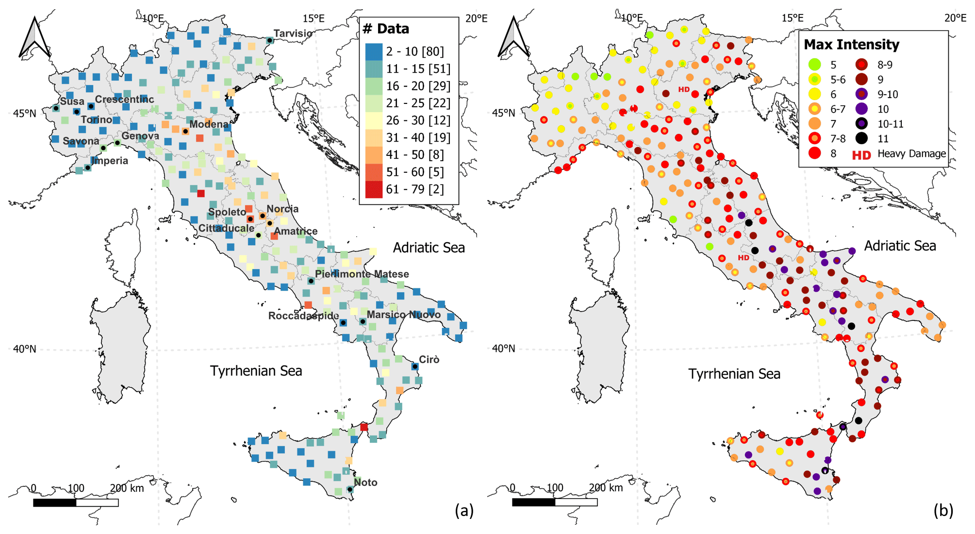
Figure 1Geographical distribution of the 228 selected sites. (a) Number of intensity data greater than or equal to 5 MCS per locality; numbers in squared brackets indicate the total of the localities in each class of data. (b) Maximum intensity observed at each locality. The sites cited in the text and borders of administrative regional areas are reported in the maps.
Intensity data can be calculated where the effects of a given earthquake with known location and magnitude are missing. A common methodology relies on the use of intensity prediction equations (IPEs) for computing an intensity value at a considered locality as a function of the source-to-site distance and the magnitude or epicentral intensity of an earthquake. The most recent IPE for the Italian area was published by Pasolini et al. (2008) and is based on a classical functional form, similar to that used for ground motion prediction equations (GMPEs), with the physical terms of geometric spreading and anelastic attenuation (Mak et al., 2015). This IPE, recently recalibrated by Lolli et al. (2019) using the data collected in the DBMI15 v.1.5 (Locati et al., 2016) and CPTI15 v.1.5 (Rovida et al., 2016, 2020b), was used in this study.
As extensively discussed in Albarello and D'Amico (2004) and Antonucci et al. (2021), a way to express the uncertainties related to each intensity estimation is using a probabilistic approach. In particular, the intensity value calculated at the site by the IPE is estimated through a normal probability distribution using the average μ and the standard deviation σ determined by Pasolini et al. (2008) and Lolli et al. (2019) as a function of epicentral parameters contained in CPTI15.
Furthermore, when the intensity related to a given earthquake is not documented at the considered site but is available at close sites, the value estimated with the IPE can be constrained with such intensity values (Albarello et al., 2007) observed in at least one neighboring (within 20 km) locality. The distance of 20 km was selected through an analysis on more than 15 000 Italian sites contained in DBMI15. We investigated the geographic distribution of these localities calculating the number of localities within a set of possible distance thresholds for every site (Antonucci et al., 2021). In particular, with a Bayesian approach, it is possible to estimate the discrete probability density distribution pl(Is|Iv) at a given site, associating to each possible intensity degree Is at the site s a probability value conditioned by the occurrence of effects of intensity Iv at nearby sites v:
where pl(Is) is the “prior” normal probability distribution estimated through the IPE, and the conditional probability q(Iv|Is) represents the correlation between intensity values at neighboring localities estimated empirically from a dataset of earthquakes and their observed IDPs. The latter probability is fixed and can be estimated from the relative frequencies of the differences between any pair of intensity values observed at the nearby sites as reported in DBMI15 (for details, see Antonucci et al., 2021). In function of the number of neighboring sites within 20 km of distance, Eq. (1) can be iteratively applied, substituting the prior distribution pl(Is) with the output of the preceding estimate. If the intensity documented at the close sites is uncertain (e.g., 6–7 MCS), an equal probability is assigned to each of the two contiguous degrees as explained in Antonucci et al. (2021). In other words, this approach (i) estimates an intensity value at the considered site from the epicentral location and magnitude of a given earthquake through an IPE expressed in a probabilistic form and (ii) uses the intensity values documented for the same event at close localities for constraining the value obtained through the IPE. Differently from the existing IPEs, this procedure is thought to better model the non-isotropic decay of intensity with distance, considering the values documented at nearby localities. In this way, the seismic history of any place can be integrated with an estimate of the number and severity of the earthquake effects that, although not documented, likely occurred at the site either because they are reported at nearby localities or because earthquakes of given magnitudes took place within a certain distance from the place.
To analyze the number and the entity of undocumented macroseismic effects that might have occurred in Italy in the past, a dataset of sample localities was defined. The dataset was selected according to the geographical distribution of the localities and the number of associated macroseismic observations in DBMI15, exclusively based on expert judgment without the use of automatic procedures. These sites had to present a homogeneous and dense distribution over the Italian territory while also finding a good compromise between main cities and small villages. Moreover, the selection considered both the differences in the urbanization in Italy and the distance of 20 km among localities, which is adopted in the Bayesian procedure for estimating the intensities (Antonucci et al., 2021). The selected dataset includes 228 sites (Table S1 in the Supplement) distributed over the whole Italian territory, with the exception of localities in the very low-seismicity area of Sardinia that present too few data, and represents a choice among the localities with (i) the highest number of intensity data collected in DBMI15 and (ii) their geographical distribution, also taking into account the distances from one another. In particular, the seismic histories of the 228 localities have at least two intensity values greater than or equal to 5 MCS (Fig. 1) with a total of 10 323 macroseismic data ranging in intensity from 2 to 10–11 MCS. In addition, the 228 sites have 2201 data expressed with non-conventional descriptive codes (e.g., “HD” for heavy damage; see Locati et al., 2022).

Figure 2Probability of undocumented effects with intensity ≥ 6 MCS estimated both with only the use of the IPE (white dots) and with the Bayesian approach considering also nearby IDPs (black dots) at (a) Susa, (b) Modena, (c) Spoleto and (d) Roccadaspide.
Focusing on the data with observed intensity ≥ 5 MCS (Fig. 1a), the number of macroseismic observations exceeds 50 at 7 localities only, and 80 sites have less than 10 intensity data, most of them located in northern Italy. In addition, at almost the totality of selected sites (216 out of 228), effects of intensity ≥ 6 MCS have been documented. Figure 1b shows that some sites located in the areas with low seismicity (i.e., parts of northern Italy) have observed a maximum intensity equal to 5 and 6 MCS. On the contrary, many localities placed in part of central and southern Italy have suffered a maximum intensity greater than or equal to 10 MCS due to high-seismicity areas.
The entity of a given effect is computed at each selected site for each earthquake in CPTI15 when the respective IDP is lacking in DBMI15 (see Sect. 3). As a result, the intensities corresponding to undocumented effects are estimated in two ways: (i) from earthquake parameters through the adopted IPE, i.e., effects neither documented at the site nor in the sites nearby but likely to have happened on the basis of the content of the earthquake catalogue, and (ii) by integrating the above information with observations available at other localities within 20 km from the considered site (see Eq. 1). It is assumed that in the last case, the probability that the considered intensity threshold has actually been reached is better constrained than in the former case. Intensity data inferred from the IPE, either “corrected” with macroseismic observations available at nearby localities or not, can be considered “potentially lost” data because, although the locality likely experienced a given level of shaking as a consequence of a known earthquake, this is not documented.
5.1 Site-by-site analysis
The earthquake effects at the selected sites can be analyzed on a site-by-site basis in order to evaluate (i) the number of undocumented effects at the considered sites and (ii) the probability that each of these effects might have reached a given intensity level. In other words, we estimated the probability of having an undocumented intensity value at each of the considered sites. Figure 2 shows, as an example, the results obtained at four sites in terms of the probability of reaching or exceeding intensity 6 MCS, estimated through the Bayesian approach described above. These sites (see Fig. 1 for location) were selected to represent geographical areas characterized by different levels of seismicity: (i) Susa in the western Alps, (ii) Modena in the Po Plain, (iii) Spoleto in the central Apennines and (iv) Roccadaspide in southern Italy.

Figure 3Probability of undocumented effects with intensity ≥ 8 MCS estimated both with the use of only the IPE (white dots) and with the Bayesian approach considering also nearby IDPs (black dots) at (a) Susa, (b) Modena, (c) Spoleto and (d) Roccadaspide.
As shown in Fig. 2, the undocumented effects at the four sites are quite different in terms of both the total number and the exceedance probabilities. Regarding the total number of effects, the highest numbers were estimated at Spoleto (central Apennines) and Roccadaspide (southern Italy) with 93 and 45 effects with intensity ≥ 6 MCS possibly lost, respectively. For the two localities in northern Italy, the undocumented effects are 39 in Modena (Po Plain) and only 9 in Susa (western Alps); for the latter, all the events occurred after 1760. The number of estimated undocumented effects represents an overview of the analysis that does not consider the differences in terms of exceedance probability computed for each event. In fact, the number of effects estimated at each site changes considerably according to their probabilities. For example, Fig. 2a shows that at Susa only one effect with intensity ≥ 6 MCS can be considered potentially lost with a probability equal to 94 %. This effect was estimated for the earthquake that occurred on 26 October 1914 with Mw 5.2, located 26 km from the site. The value resulting from the IPE was constrained with four intensity data equal to 6 MCS and one equal to 6–7 MCS documented at close localities (https://emidius.mi.ingv.it/CPTI15-DBMI15/eq/19141026_0345_000, last access: 3 August 2022). Figure 2b shows that two events have a higher probability to have produced effects greater than or equal to 6 MCS at Modena. The first one has a probability of 76 % and derives from one of the strongest earthquakes that occurred in northern Italy, i.e., the 3 January 1117 earthquake of Mw equal to 6.5 and located about 70 km from Modena (https://emidius.mi.ingv.it/CPTI15-DBMI15/eq/11170103_1515_000, last access: 3 August 2022). This probability was estimated through the use of only the IPE because the macroseismic intensity distribution in DBMI15 (from Guidoboni et al., 2007) shows very scattered data, and none of these were documented at sites within 20 km from Modena. The second effect has a probability of 62 % and is related to the main shock of the 2012 Emilia sequence (29 May 2012; Mw 5.9), which struck parts of northern regions (https://emidius.mi.ingv.it/CPTI15-DBMI15/eq/20120529_0700_000, last access: 3 August 2022). Several undocumented effects were estimated for the shocks of the 2012 sequence because no intensities were assigned at Modena for any shock during the macroseismic survey (Tertulliani et al., 2012). Figure 2c shows that eight effects with intensity ≥ 6 MCS can be considered potentially lost at Spoleto with a probability greater than 75 %, and all are estimated from earthquakes with epicenters located between 10 and 52 km. For four of these effects, the estimated probability is greater than 95 %. All these probabilities are calculated by constraining the value obtained by the IPE with intensity values documented at close localities, with the exception of the earthquake that occurred on 26 October 2016 for which no IDPs are available within 20 km from Spoleto. Regarding Roccadaspide (Fig. 2d), four effects have probabilities higher than 95 % of reaching or exceeding intensity 6 MCS, all constrained with the Bayesian approach using the intensity data documented at close localities.
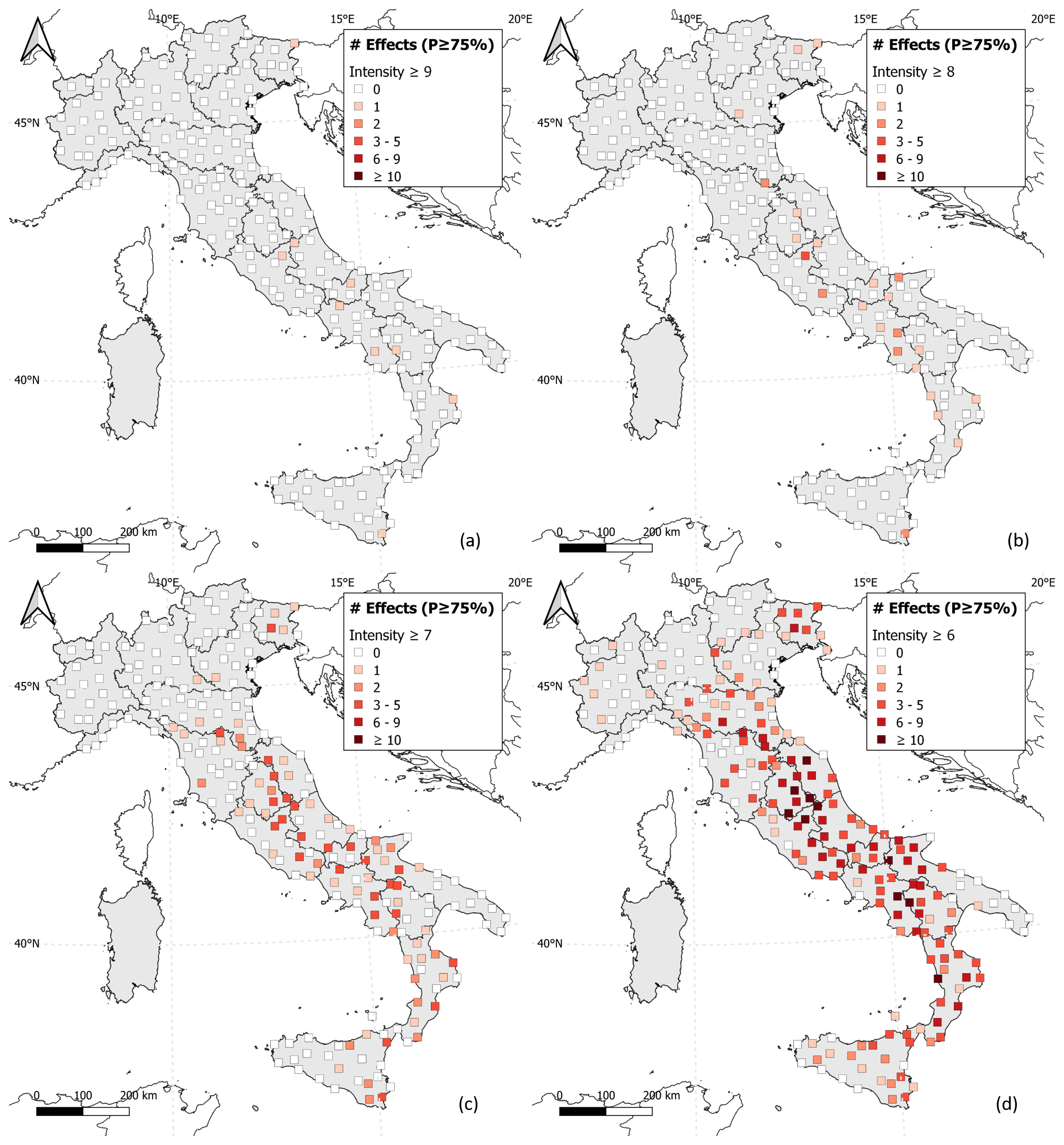
Figure 4Number of undocumented effects at each selected site with probabilities ≥ 75 % of reaching or exceeding intensity (a) 9, (b) 8, (c) 7 and (d) 6 MCS.
The exceedance probabilities for higher intensity levels, i.e., greater than or equal to 7, 8 and 9 MCS, were also calculated and analyzed. Figure 3 reports the results obtained for intensities greater than or equal to 8 MCS at the same four sites of Fig. 2. In particular, Fig. 3a and b show that the earthquakes that might have produced an intensity at least equal to 6 MCS (Fig. 2a and b) were not able to produce an intensity ≥ 8 MCS at Susa and Modena. On the other hand, with regard to Spoleto (Fig. 3c), the earthquake that occurred on 1 December 1328 with Mw 6.5, at about 27 km from the site, may have produced an intensity ≥ 8 MCS with 80 % probability. In this case, the estimate provided by the IPE was constrained through the intensity 9 MCS documented (Monachesi, 1987) at a locality very close to Spoleto (https://emidius.mi.ingv.it/CPTI15-DBMI15/eq/13281201_0000_000, last access: 3 August 2022). Figure 3d shows that two effects with intensity ≥ 8 MCS can be considered potentially lost with high probability (> 80 %) at Roccadaspide. These effects are related to two events that occurred very close in time, on 31 July and 19 August 1561, that struck southern Italy with Mw equal to 6.7 and 6.3, respectively. Both these events were located about 30 km from the considered site, and macroseismic intensity data are available at nearby localities that allowed us to constrain the intensity values obtained with the IPE.

Figure 5Probability that at least one effect of intensity ≥ (a) 9, (b) 8, (c) 7 and (d) 6 was not documented at the 228 selected sites.
5.2 Geographical distribution of potentially lost effects
As shown in the previous section, each undocumented effect estimated at a site has different exceedance probabilities for different intensity levels. In this respect, the number of effects potentially lost at the 228 selected sites can be quantified selecting a given probability threshold. For this purpose, at each site, we counted the number of undocumented effects with probabilities ≥ 75 % (i.e., the third quartile of the entire probability distribution) of reaching or exceeding intensity levels 6, 7, 8 and 9 MCS (Fig. 4). Figure 4a shows that one effect was potentially lost at nine localities assuming a probability threshold equal to 75 % for intensity ≥ 9 MCS. For one of these sites, i.e., Tarvisio in northeastern Italy (see Fig. 1), the estimated effect derived from the earthquake that occurred on 25 January 1348 with Mw equal to 6.6 and its epicenter very close to the site (less than 1 km, according to CPTI15). The undocumented effect estimated at Noto in southeastern Sicily (see Fig. 1) is related to the Mw 7.3 earthquake that occurred on 11 January 1693 (https://emidius.mi.ingv.it/CPTI15-DBMI15/eq/16930111_1330_000, last access: 3 August 2022). However, this effect should not be considered in this analysis because Noto was rebuilt and relocated after that event, which struck the Sicilian island causing the total destruction of many sites, including the site today known as Noto Antica located about 7 km from the present-day town. With regard to intensities ≥ 8 MCS, Fig. 4b shows that effects with an exceedance probability of ≥ 75 % are calculated at 23 localities for a total of 31 potentially lost effects. In detail, Cittaducale (see Fig. 1), in central Italy, shows three potentially lost effects: one of these is related to the poorly constrained (17 IDPs; Guidoboni et al., 2007) event that occurred on 9 September 1349 in the central Apennines with Mw equal to 6.3 and the epicenter about 19 km from the site (https://emidius.mi.ingv.it/CPTI15-DBMI15/eq/13490909_0000_000, last access: 3 August 2022). Figure 4c shows that for the sites located in a large part of northern Italy, in the Tyrrhenian regions and in the southeastern region, no effects with an intensity ≥ 7 MCS were computed; on the contrary, 150 potentially lost effects were estimated at 76 sites, principally located along the central Apennines and in southern Italy. The results obtained for intensity ≥ 6 MCS are completely different. In fact, as shown in Fig. 4d, the number of potentially lost effects is 617, estimated at 153 out of 228 sites, located almost everywhere except for some areas in the central Alps and in the northwestern regions. The undocumented effects are more than 10 for 10 localities, and two of these, i.e., Norcia and Amatrice (central Italy; Fig. 1), are equal to 19 and 17, respectively. In general, the maps in Fig. 4 show that for some localities placed in parts of northwestern Italy and the central Alps no undocumented effects were estimated. In contrast, at least one effect that can be considered potentially lost for intensity ≥ 6 MCS was computed at most of the 228 considered sites, except for 75 sites mostly located in the same low-seismicity areas. This is consistent with the features of the seismicity of the Italian area, which shows low seismicity in the western and central Alps and strong and more frequent events in the central and southern Apennines and Sicily (see Rovida et al., 2020b, 2022b).
Taking into account the different exceedance probabilities computed at each locality for N undocumented earthquakes, it was possible to estimate the probability that at least one effect was not documented at the 228 selected sites for different intensity levels. This represents another way to analyze the outcomes obtained site by site (Sect. 5.1). Given the exceedance probabilities pl(Is) relative to the intensity threshold Is for the lth of N earthquakes, the probability L(Is) that at least one effect with intensity greater than or equal to Is has been lost is given by
The results of the analysis for different intensity levels Is are reported in Fig. 5. In particular, the map shown in Fig. 5a represents the probability that at least one effect of intensity ≥ 9 MCS was not documented at the selected sites: a probability greater than 5 % was estimated at 41 sites, exceeding 95 % only at five localities, principally located in central and southern Italy (Amatrice, Cirò, Marsico Nuovo, Piedimonte Matese and Noto; Fig. 1). Figure 5b shows that the probability of having at least one effect of intensity ≥ 8 MCS that can be considered potentially lost is greater than 95 % at 16 sites in the northeast, in central and southern Italy; on the contrary, low probabilities (< 5 %) result at a few localities placed in southern and central Italy and at most of the sites in the north. The results obtained for lower intensity levels (i.e., intensity 6 and 7 MCS) appear quite different. In fact, the map in Fig. 5c shows that a probability greater than 50 % of having at least one undocumented effect with intensity ≥ 7 MCS was estimated at 150 localities; out of these, 91 sites mostly located in central and southern Italy have probabilities greater than 95 %. Low probabilities (< 5 %) result at 18 sites, principally in northern Italy. Regarding intensity threshold 6, Fig. 5d shows that the probability of at least one potentially lost effect exceeds 50 % at almost the totality of the considered sites (211 out of 228), whereas lower probabilities (< 25 %) result at only five sites located in the northwestern regions (Savona, Genova, Imperia, Crescentino, Torino; see Fig. 1 for their location).
This work provides a probabilistic methodology devoted to the quantitative estimate of the effects of past Italian earthquakes that can be considered potentially lost at a sample set of sites and analyzes the results both at the local (site by site) and national scale. The results show some gaps in the macroseismic data contained in DBMI15, despite their quality and quantity. Indeed, at least one damage effect with intensity ≥ 6 MCS could be potentially lost with a probability greater than 95 % at many of the selected sites (i.e., 173 out of 228). Considering the overall number of potentially lost effects (Fig. 4), they strongly decrease with increasing intensity, from 617 of intensity ≥ 6 MCS to 31 of intensity ≥ 8 MCS and just 9 of intensity ≥ 9 MCS. The reason is that severe damage or destruction suffered at a locality, represented by intensities 8 and 9 MCS, is more likely to have been recorded by historical sources. On the contrary, slight damage, corresponding to intensity 6 MCS, may have left less significant traces in the historical record of a locality. Unreported macroseismic data of any intensity might be related to earthquakes of any size and period, including the most recent and strong ones. From a geographical point of view, few undocumented effects were computed at the sites located in a large part of northwestern Italy, in the central Alps, and in the southern Adriatic region and Sicily compared to those estimated in central and southern Italy (principally along the Apennines), independently of the considered intensity level. These discrepancies are likely representative of the differences in the seismicity of the Italian territory, with the number and strength of the earthquakes located in central and southern Italy clearly greater than in other areas. However, these results point out that the seismic history of one site might be different from the others, also within short distances. This probably depends on the relative importance that a locality had through time because the story of main towns is more documented with respect to minor ones.
The joint analysis of macroseismic intensity data observed through time in a place and those calculated through an IPE, constrained with data observed at nearby localities with the Bayesian procedure described in Antonucci et al. (2021), provides a general methodology to investigate the knowledge of seismic histories and to estimate the level of representativeness of each site in function of the seismicity of a given area. The results are given in a probabilistic form that allows considering both the uncertainties related to the assessment of intensity at a given site and the nature of macroseismic data (ordinal, discrete and range-limited). Such a procedure is repeatable and applicable to other regions and contexts. However, the outcomes are strictly dependent on the number of earthquakes and the reliability of the parameters contained in the input seismic catalogue as well as on the adopted IPE, with its specific functional form and parameters, and the associated uncertainties. In this regard, particular care should be given to the interpretation of the results, considering that the content of a catalogue is progressively less representative of the actual seismicity going back in time, especially for small events. This implies that changing both the considered catalogue and IPE could considerably change the results in terms of calculated undocumented effects at the sites.
Regardless of these limitations, the analyses show that the intensity data documented at a given site may not be representative of the actual shaking experienced through time even with an enormous number of macroseismic data, such as in Italy. Consequently, the use of these data for several seismic analyses, such as intensity-based seismic hazard assessment at a local scale and testing of probabilistic seismic hazard models, should include a careful preliminary analysis of the representativeness and completeness of macroseismic data at the sites, regardless of the study area considered. For this purpose, the main future goal will be checking the consistency of these results with those obtained through an in-depth historical investigation, which is the only way of providing robust quantitative estimates of the temporal completeness of the seismic history of a site for different intensity levels.
DBMI15 is available at https://doi.org/10.13127/DBMI/DBMI15.4 (Locati et al., 2022). CPTI15 is available at https://doi.org/10.13127/CPTI/CPTI15.4 (Rovida et al., 2022b).
The supplement related to this article is available online at: https://doi.org/10.5194/nhess-23-1805-2023-supplement.
AA edited most parts of the paper and performed the statistical analyses. AR, VD'A and DA contributed to the manuscript and supervised the research.
The contact author has declared that none of the authors has any competing interests.
Publisher’s note: Copernicus Publications remains neutral with regard to jurisdictional claims in published maps and institutional affiliations.
The authors wish to thank Carlos Hector Caracciolo, Josep Batlló, Raffaele Azzaro and the editor Animesh Gain for their comments and suggestions. The authors wish to warmly thank Mario Locati for his constant support and Paola Albini for her comments and suggestions on this work and, in general, for her valuable and continuous teachings on historical seismology.
This paper was edited by Animesh Gain and reviewed by Carlos H. Caracciolo, Josep Batlló, and Raffaele Azzaro.
Albarello, D. and D'Amico, V.: Attenuation relationship of macroseismic intensity in Italy for probabilistic seismic hazard assessment, B. Geofis. Teor. Appl., 45, 271–284, 2004.
Albarello, D., Camassi, R., and Rebez, A.: Detection of space and time heterogeneity in the completeness of a seismic catalog by a statistical approach: An Application to the Italian Area, B. Seismol. Soc. Am., 91, 1694–1703, https://doi.org/10.1785/0120000058, 2001.
Albarello, D., D'Amico, V., Gasperini, P., Pettenati, F., Rotondi, R., and Zonno G.: Nuova formulazione delle procedure per la stima dell'intensità macrosismica da dati epicentrali o da risentimenti in zone vicine, Progetto DPC-INGV S1, http://esse1.mi.ingv.it/d10.html (last access: 22 March 2023), 2007.
Albini, P.: Documenting Earthquakes in the United States of the Ionian Islands, 1815–1864, Seismol. Res. Lett., 91, 2554–2562, https://doi.org/10.1785/0220200056, 2020.
Albini, P. and Rovida, A.: Earthquakes in southern Dalmatia and coastal Montenegro before the large 6 April 1667 event, J. Seismol., 22, 721–754, https://doi.org/10.1007/s10950-018-9730-4, 2018.
Albini, P., Camassi, R., Castelli, V., and Stucchi, M. (Ed.): Miglioramento della qualità delle informazioni macrosismiche per un loro utilizzo nella valutazione della pericolosità sismica, Rapporto Tecnico INGV-MI per il Servizio Sismico Nazionale, Milano, 195 (Parte A, 43 pp.; Parte B, 152 pp.), 2001.
Albini, P., Stucchi, M., and Mirto, C.: Valutazione di completezza, su base storica, dei dati del catalogo sismico CPTI (1999) nell'area corrispondente alle ZS n. 5 e 6 in ZS4 (Belluno/Cansiglio e Asolo/Vittorio Veneto), Progetto GNDT “Scenari di danno in area veneto-friulana”, Rapporto Tecnico INGV-MI, 25 pp., 2003.
Albini, P., Locati, M., Rovida, A., and Stucchi, M.: European Archive of Historical EArthquake Data (AHEAD), Istituto Nazionale di Geofisica e Vulcanologia (INGV) [data set], https://doi.org/10.6092/ingv.it-ahead, 2013.
Antonucci, A., Rovida, A., D'Amico, V., and Albarello, D.: Integrating macroseismic intensity distributions with a probabilistic approach: an application in Italy, Nat. Hazards Earth Syst. Sci., 21, 2299–2311, https://doi.org/10.5194/nhess-21-2299-2021, 2021.
Azzaro, R. and Castelli, V.: Materiali per un catalogo di terremoti etnei dal 1600 al 1831, Quaderni di Geofisica, 123, Istituto Nazionale di Geofisica e Vulcanologia (INGV), Roma, 284 pp., https://doi.org/10.13127/qdg/123, 2015.
Azzaro, R., Barbano, M. S., D'Amico, S., and Tuvè, T.: The attenuation of seismic intensity in the Etna region and comparison with other Italian volcanic districts, Ann. Geophys.-Italy, 49, 1003–1020, https://doi.org/10.4401/ag-3113, 2006.
Bakun, W. H. and Wentworth, C. M.: Estimating earthquake location and magnitude from seismic intensity data, B. Seismol. Soc. Am., 87, 1502–1521, 1997.
Baratta, M.: I terremoti d'Italia, Saggio di storia geografia e bibliografia sismica italiana, Torino, 951 pp., 1901.
Camassi, R.: Catalogues of historical earthquakes in Italy, Ann. Geophys.-Italy, 47, 645–657, https://doi.org/10.4401/ag-3329, 2004.
Camassi, R., Castelli, V., Molin, D., Bernardini, F., Caracciolo, C. H., Ercolani, E., and Postpischl, L.: Materiali per un catalogo dei terremoti italiani: eventi sconosciuti, rivalutati o riscoperti. Quaderni di Geofisica, 96, Istituto Nazionale di Geofisica e Vulcanologia (INGV), Roma, 53 pp., 2011.
Carletti, F. and Gasperini, P.: Lateral variations of seismic intensity attenuation in Italy, Geophys. J. Int., 155, 839–856, https://doi.org/10.1111/j.1365-246X.2003.02073.x, 2003.
D'Amico, V. and Albarello, D.: SASHA: A Computer Program to Assess Seismic Hazard from Intensity Data, Seismol. Res. Lett., 79, 663–671, https://doi.org/10.1785/gssrl.79.5.663, 2008.
Faenza, L. and Michelini, A.: Regression analysis of MCS intensity and ground motion parameters in Italy and its application in ShakeMap, Geophys. J. Int., 180, 1138–1152, https://doi.org/10.1111/j.1365-246X.2009.04467.x, 2010.
Gasparini, C., Conte, S., Rocchetti, E., Saraceni, A. M., and Vannucci, C.: Bollettino macrosismico 1999, Istituto Nazionale di Geofisica (INGV), Roma, 99 pp., 2003.
Gasparini, C., Conte, S., and Vannucci, C.: Bollettino macrosismico 2001–2005, Istituto Nazionale di Geofisica e Vulcanologia (INGV), Roma, CD-ROM, 2011.
Gasperini, P., Bernardini, F., Valensise, G., and Boschi, E.: Defining seismogenic sources from historical earthquake felt reports, B. Seismol. Soc. Am., 89, 94–110, 1999.
Gasperini, P., Vannucci, G., Tripone, D., and Boschi, E.: The Location and Sizing of Historical Earthquakes Using the Attenuation of Macroseismic Intensity with Distance, B. Seismol. Soc. Am., 100, 2035–2066, https://doi.org/10.1785/0120090330, 2010.
Gomez-Capera, A. A., D'Amico, M., Lanzano, G., Locati, M., and Santulin, M.: Relationships between ground motion parameters and macroseismic intensity for Italy, B. Earthq. Eng., 18, 5143–5164, 2020.
Grünthal, G.: European Macroseismic Scale 1998 (EMS-98), Cahiers du Centre Européen de Géodynamique et de Séismologie, 13, 1–99, 1998.
Guidoboni, E., Ferrari, G., Mariotti, D., Comastri, A., Tarabusi, G., and Valensise, G.: CFTI4Med, Catalogue of Strong Earthquakes in Italy (461 B.C.–1997) and Mediterranean Area (760 B.C-.-1500), INGV-SGA, http://storing.ingv.it/cfti4med/ (last access: 22 March 2023), 2007.
Locati, M., Rovida, A., Albini, P., and Stucchi, M.: The AHEAD Portal: A Gateway to European Historical Earthquake Data, Seismol. Res. Lett., 85, 727–734, https://doi.org/10.1785/0220130113, 2014.
Locati, M., Camassi, R., Rovida, A., Ercolani, E., Bernardini, F., Castelli, V., Caracciolo, C. H., Tertulliani, A., Rossi, A., Azzaro, R., D'Amico, S., Conte, S., and Rocchetti, E.: Database Macrosismico Italiano (DBMI15), Istituto Nazionale di Geofisica e Vulcanologia (INGV) [data set], https://doi.org/10.13127/DBMI/DBMI15.2, 2016.
Locati, M., Camassi, R., Rovida, A., Ercolani, E., Bernardini, F., Castelli, V., Caracciolo, C. H., Tertulliani, A., Rossi, A., Azzaro, R., D'Amico, S., Conte, S., Rocchetti, E., and Antonucci, A.: Database Macrosismico Italiano (DBMI15), versione 4.0, Istituto Nazionale di Geofisica e Vulcanologia (INGV) [data set], https://doi.org/10.13127/DBMI/DBMI15.4, 2022.
Lolli, B., Pasolini, C., Gasperini, P., and Vannucci, G.: Prodotto 4.8: Ricalibrazione dell'equazione di previsione di Pasolini et al. (2008), in: Meletti, C. e Marzocchi, W. (a cura di), Il modello di pericolosità sismica MPS19, rapporto finale, Centro Pericolosità Sismica, Istituto Nazionale di Geofisica e Vulcanologia, maggio 2019, Roma, 168 pp., 2019.
Mak, S., Clements, R. A., and Schorlemmer, D.: Validating Intensity Prediction Equations for Italy by Observations, B. Seismol. Soc. Am., 105, 2942–2954, https://doi.org/10.1785/0120150070, 2015.
Medvedev, S., Sponheuer, W., and Karník, V.: Neue seismische Skala Intensity scale of earthquakes, in: 7. Tagung der Europäischen Seismologischen Kommission vom 24.9. bis 30.9.1962, in Jena, Veröff. Institut für Bodendynamik und Erdbebenforschung in Jena, Deutsche Akademie der Wissenschaften zu Berlin, 77, 69–76, 1964.
Molin, D., Bernardini, F., Camassi, R., Caracciolo, C. H., Castelli, V., Ercolani, E., and Postpischl, L.: Materiali per un catalogo dei terremoti italiani: revisione della sismicità minore del territorio nazionale, Quaderni di Geofisica, 57, Istituto Nazionale di Geofisica e Vulcanologia (INGV), Roma, 75 pp., 2008.
Monachesi, G. (Ed.): Revisione della sismicità di riferimento per i comuni di Cerreto d'Esi (AN), Esanatoglia (MC), Serra San Quirico (AN), Osservatorio Geofisico Sperimentale, Macerata, Internal report, 240 pp., 1987.
Oliveti, I., Faenza, L., and Michelini, A.: New reversible relationships between ground motion parameters and macroseismic intensity for Italy and their application in ShakeMap, Geophys. J. Int., 231, 1117–1137, https://doi.org/10.1093/gji/ggac245, 2022.
Pasolini, C., Albarello, D., Gasperini, P., D'Amico, V., and Lolli, B.: The attenuation of seismic intensity in Italy, Part II: Modeling and validation, B. Seismol. Soc. Am., 98, 692–708, https://doi.org/10.1785/0120070021, 2008.
Provost, L. and Scotti, O.: QUake-MD: Open-Source Code to Quantify Uncertainties in Magnitude–Depth Estimates of Earthquakes from Macroseismic Intensities, Seismol. Res. Lett., 91, 2520–2530, https://doi.org/10.1785/0220200064, 2020.
Rovida, A., Locati, M., Camassi, R., Lolli, B., and Gasperini, P. (Eds.): Catalogo Parametrico dei Terremoti Italiani (CPTI15), Istituto Nazionale di Geofisica e Vulcanologia (INGV) [data set], https://doi.org/10.6092/INGV.IT-CPTI15, 2016.
Rovida, A., Locati, M., Antonucci, A., and Camassi, R.: Italian Archive of Historical Earthquake Data (ASMI), Istituto Nazionale di Geofisica e Vulcanologia (INGV) [data set], https://doi.org/10.13127/asmi, 2017.
Rovida, A., Albini, P., Locati, M., and Antonucci, A.: Insights into Preinstrumental Earthquake Data and Catalogs in Europe, Seismol. Res. Lett., 91, 2546–2553, https://doi.org/10.1785/0220200058, 2020a.
Rovida, A., Locati, M., Camassi, R., Lolli, B., and Gasperini, P.: The Italian earthquake catalogue CPTI15, B. Earthq. Eng, 18, 2953–2984, https://doi.org/10.1007/s10518-020-00818-y, 2020b.
Rovida, A., Antonucci, A., and Locati, M.: The European Preinstrumental Earthquake Catalogue EPICA, the 1000–1899 catalogue for the European Seismic Hazard Model 2020, Earth Syst. Sci. Data, 14, 5213–5231, https://doi.org/10.5194/essd-14-5213-2022, 2022a.
Rovida, A., Locati, M., Camassi, R., Lolli, B., Gasperini, P., and Antonucci, A.: Catalogo Parametrico dei Terremoti Italiani (CPTI15), versione 4.0, Istituto Nazionale di Geofisica e Vulcanologia (INGV) [data set], https://doi.org/10.13127/CPTI/CPTI15.4, 2022b.
Sieberg, A.: Geologische, physikalische und angewandte Erdbebenkunde, G. Fischer, Jena, 1923.
Stucchi, M.: Historical seismology and seismic hazard, Ann. Geophys.-Italy, 36, 177–189, https://doi.org/10.4401/ag-4314, 1993.
Stucchi, M., Albini, P., Mirto, M., and Rebez, A.: Assessing the completeness of Italian historical earthquake data, Ann. Geophys.-Italy, 47, 2–3, https://doi.org/10.4401/ag-3330, 2004.
Stucchi, M., Meletti, C., Montaldo, V., Crowley, H., Calvi, G. M., and Boschi, E.: Seismic hazard assessment (2003–2009) for the Italian building code, B. Seismol. Soc. Am., 101, 1885–1911, https://doi.org/10.1785/0120100130, 2011.
Tertulliani, A., Arcoraci, L., Berardi, M., Bernardini, F., Brizuela, B., Castellano, C., Del Mese, S., Ercolani, E., Graziani, L., Maramai, A., Rossi, A., Sbarra, M., and Vecchi, M.: Emilia 2012 sequence: the macroseismic survey, in: The Emilia (northern Italy) seismic sequence of May–June, 2012: preliminary data and results, edited by: Anzidei, M., Maramai, A., and Montone, P., Ann. Geophys.-Italy, 55, 679–687, https://doi.org/10.4401/ag-6140, 2012.
Wood, H. O. and Neumann, F.: Modified Mercalli intensity scale of 1931, B. Seismol. Soc. Am., 21, 277–283, https://doi.org/10.1785/BSSA0210040277, 1931.