the Creative Commons Attribution 4.0 License.
the Creative Commons Attribution 4.0 License.
 | 12 Aug 2022
Comparison of sustainable flood risk management by four countries – the United Kingdom, the Netherlands, the United States, and Japan – and the implications for Asian coastal megacities
Faith Ka Shun Chan
Gordon Mitchell
Nigel Wright
Mingfu Guan
Xiaohui Lu
Zilin Wang
Burrell Montz
Olalekan Adekola
Sustainable flood risk management (SFRM) has become popular since the 1980s. Many governmental and non-governmental organisations have been keen on implementing the SFRM strategies by integrating social, ecological, and economic themes into their flood risk management (FRM) practices. However, the justifications for SFRM are still somewhat embryonic, and it is not yet clear whether this concept is influencing current policies in different countries. This paper reviews the past and current flood management experiences from flood defence to SFRM in four developed countries to highlight lessons for coastal megacities in development. The paper explores recent strategies such as “Making Space for Water”, Planning Policy Statement 25 (PPS25), and the National Planning Policy Framework (NPPF) in the UK and “Room for the River” in the Netherlands, which were implemented to mitigate flooding, integrate FRM with sustainability concepts, and deliver sound FRM practice for future generations. In this context, the United States has also established a National Flood Insurance Program (NFIP), and in a different approach, Japan has developed an advanced flood warning and evacuation contingency system to prepare for climatic extremes. These case studies give good lessons in achieving long-term SFRM to deliver sound flood management practices considering socio-economic and environmental concerns. Most developing coastal megacities especially in Asia are still heavily reliant on a traditional hard-engineering approach, which may not be enough to mitigate substantial risks due to human factors (e.g. large population, rapid socio-economic growth, subsidence from excessive groundwater extraction) and natural factors (e.g. climate change including sea-level rise and land subsidence). It is clear that different countries and cities have their interpretation of SFRM, but this paper explores how policymakers can adopt “mixed options” to move towards long-term thinking about sustainability with social, economic, and environmental considerations.
- Article
(6002 KB) - Full-text XML
- BibTeX
- EndNote


Flooding is a natural phenomenon that has occurred over a long period of human history (Plate, 2002; Yang et al., 2019). Different types of flood can be caused by coastal flooding – storm, high tides, sea-level rise, and insufficient protection; river/fluvial floods – snowmelt or high precipitation in catchment areas leading to flash floods or riverine floods; pluvial floods – extreme rainfall and failing drainage systems or compound floods from cyclonic monsoon effects enhancing intensive rainstorms and surges together; or rapid snowmelt (Kundzewicz, 1999). In Asian coastal megacities, flood risk and the frequency and impact of floods are increasing (Hanson et al., 2011; Hallegatte et al., 2013; Yang et al., 2015; Chan et al., 2021, 2022), through two routes. First, flood hazard is increasing as climate change raises sea surface temperature, driving oceanic thermal expansion and increasing the intensity and frequency of precipitation events and natural land subsidence (Meehl et al., 2007; Hulme et al., 2002). Second, the assets exposed to flood hazards, including people and property, are growing through rapid land-use change, urbanisation, and economic expansion (Yang et al., 2010). Ways to mitigate flood risk in urban coastal areas are varied, and in principle could necessitate relocation of people and properties from high-risk areas; e.g. the Indonesian government is gradually moving the capital away from Jakarta. However, such measures are extreme and costly and are likely seen as impractical, with few people and firms willing to relocate, particularly from within dense economically vibrant cities such as Guangzhou, Shanghai, Jakarta, Ho Chi Minh City, Bangkok, and Singapore. A major challenge for such cities is therefore to manage flood risk whilst addressing development needs.
Looking elsewhere in Asia, for example, Cyclone Nargis flooded Yangon, Myanmar, in 2008 and led to more than 140 000 casualties and USD 17 billion in economic impact (Terry et al., 2012). In 2011, the Chao Phraya River catchment flood caused severe inundation in Bangkok, Thailand; flooded several districts of the city; and caused serious economic losses, exceeding USD 4 billion (Chan et al., 2018). These examples demonstrate that Asian coastal cities are exposed to several types of flood often in combination (e.g. surface water/waterlogging, fluvial in urban catchments, and coastal), and the impacts and consequences are highly related to growing economies and population. In addition, these cities are also experiencing complex human-induced factors (e.g. reclamation of coastal areas without considering sea-level rise and surges, inadequate urban drainage system, and over-extraction of groundwater resources that enhances land subsidence). Experience from other countries which have faced severe flooding suggests lessons for dealing with flood risk. Asian megacities tend to rely on a one-dimensional, hard-engineering approach to protect against flooding (Chan et al., 2018; Yang et al., 2020), whereas in many other places, this approach is increasingly seen as untenable as it is financially unrealistic to protect against all floods.
Therefore, flood risk management (FRM) has developed an approach that addresses not just structural defence but also preparation (e.g. land-use zoning, adaptation), non-structural protective measures, population preparedness, and emergency response and recovery mechanisms to reduce flood risk (Samuels, 2006). FRM reflects a growing awareness of the uncertainties, vulnerabilities, and costs associated with flooding and is the flooding paradigm widely accepted in Europe and some other advanced economies (Janssen, 2008) but is accepted to a much lesser extent in Asian cities. With the intention of drawing lessons for Asian coastal megacities, in this paper, we review FRM experience in four economies which are at the front end in applying the FRM approach (the UK, the Netherlands, the United States, and Japan) (Sect. 2). It additionally explores the wider concept of sustainable FRM (SFRM), which extends the scope of FRM to consider wider social and environmental goals (Sect. 3). The paper also reviews the development of flood management practices in five selected Asian coastal cities (Jakarta, Indonesia; Bangkok, Thailand; Ho Chi Minh City, Vietnam; Guangzhou, China; and Shanghai, China) to demonstrate the latest progress of FRM in these cities that are exposed to flooding from various sources and to understand the implications of SFRM elsewhere for effectively influencing their flood management practices.
The overall aim of the paper is to contribute to the understanding of SFRM and practice and to argue for consideration of flood mitigation strategies for Asian coastal megacities developed through a consideration of sustainable development principles. Making such information available is of prime importance because Asian megacities already face massive flood management challenges, and flood damage – whether human or material – is growing rapidly.
2.1 The road from traditional flood management to SFRM
Responses to flooding have historically developed through several distinct phases. Initially (pre-1980s), responses were aimed at controlling and defending against floods by relying on “hard-engineering solutions” (Penning-Rowsell et al., 2006), and there have been evidently countries (e.g. China, the Netherlands, Germany, the USA) using flood defences to protect villages and towns in low-lying deltaic areas for centuries (Wang et al., 2003; Van Stokkom et al., 2005; Parker and Fordham, 1996; Arnell, 1984). This paradigm of “flood control” (the 1950s to 1960s) sought to reduce flooding that might damage agricultural production and compromise food security and focused on the engineering approaches and materials used (e.g. concrete). Land drainage constructions and channelisation were used to quickly drain floodwater away from agricultural lands by the driving principle of increasing in-channel conveyance. This aims to reduce flood impacts on agriculture. Later in the 1970s, the paradigm of “flood defence” was adopted, as the economic interest of flood control was widened to encompass manufacturing and tertiary industries. This flood defence phase sought to protect infrastructure, people, and property by using structural engineering measures such as seawalls, dikes, embankments, breakwaters, and levees.
Through the 1980s a “flood management” approach emerged, which emphasised coping with flooding rather than solely controlling floods. This occurred as policymakers realised it was increasingly difficult to defend against all flooding due to increasing climatic extremes (i.e. intensive precipitation) whilst social and environmental concerns were also recognised as important. This change in focus gave greater attention to flood preparedness and public awareness through, for example, the flood forecasting and warning systems that were developed across Europe. Such changes have been the basis of further development of the FRM paradigm (Lumbroso et al., 2011; Parker and Fordham, 1996). In the 2000s, the focus changed again to more explicitly consider flood risk (Plate, 2002), including the probability of a given flood hazard (e.g. precipitation, storm frequency, sea-level rise) (Kundzewicz et al., 2002; Schanze et al., 2005; Tol et al., 2003) and the vulnerability of, as well as consequences for, populations and economic assets exposed to that flood hazard (Brown and Damery, 2002; Schanze, 2006). Thus, FRM now seeks to prevent damage by reducing the exposure and vulnerability of people and properties prone to flooding. It is not possible to eliminate flood risk; hence FRM considers the costs and benefits of flood risk mitigation for society at large (Butler and Pidgeon, 2011). The objective of FRM is thus to reduce the harmful consequences of flooding and to balance risk reduction alongside other political considerations and priorities. An important aspect of FRM is to manage flood risk through engagement with stakeholders more widely (e.g. households, practitioners, politicians, flood engineers, planners, and communities) to identify multi-disciplinary perspectives and solutions (Pitt, 2008; Yang, 2020).
In this context, it is important to reflect on the national experiences of FRM to identify lessons for countries where flood defence and control continue to be the dominant response to flooding. Therefore, we suggest considering the experience of flood management in the UK, the Netherlands, the USA, and Japan, where flood management practice has evolved significantly in recent decades, and we show how the practice has evolved from defending against floods to living with floods, whilst acknowledging dissimilarities of human-induced factors (e.g. urbanisation, population) and physical factors (e.g. meteorological, hydrological, topography). These valuable experiences offer lessons for FRM in Asian coastal megacities such as managing urban flooding through the integration of urban planning practices, addressing climate change and promoting sustainability.
2.2 The United Kingdom
From the early part of the 20th century, clear phases of flood management history can be identified in the UK, with the first phase pre-1970s. During this period, flood policy was governed and implemented by the Ministry of Agriculture, Fisheries and Food (MAFF), whilst the internal drainage boards (IDBs) were responsible for carrying out flood alleviation by engineering practices (drainage) in the UK. In general, the UK government adopted land drainage and hard-engineering defences such as river straightening and embankment construction in rural and urban flood policy responses during this era; this approach has prevented many minor floods and protected the agricultural infrastructure (e.g. farmlands, crops) in adverse weather. However, the major floods in 1947 and 1953, which inundated 65 000 and 280 000 ha of farmland respectively, escalated the changes and further changes of flood management strategies as these floods damaged agricultural output during the post-war period when many foodstuffs were in short supply and food production was challenging (Penning-Rowsell and Chatterton, 1977).
During the 1970s, the UK government adopted cost–benefit appraisal (CBA) to evaluate drainage projects. Where MAFF found high-yielding crops (particularly sugar beet, cereal, sugar, and potatoes) to be threatened, the IDB and local authorities would help farmers to develop measures to control flooding, usually through the construction of embankments and drainage channels (Penning-Rowsell and Green, 2000). Johnson et al. (2007) argued that despite the application of CBA by the government, flood policy was biased in favour of farmers and landowners, as they were the major (private) beneficiaries of public expenditure. However, the UK remained unusual in that it was one of few countries at the time to apply CBA to flood control measures.
During the 1980s, the priority of the UK flood policy was to “keep the water out” (Johnson et al., 2007). The emphasis had moved from protecting farmland to protecting a broader asset base that underpinned economic growth. Thus, policymakers were keen on implementing flood alleviation schemes and projects that defended people and property (homes and businesses) (Johnson and Priest, 2008). Criticism was however now directed at the use of CBA for being overly focused on economic aspects. For example, flood measures/schemes tended to be approved if they protected high-value properties in a floodplain (e.g. riverside houses) but ignored adverse ecological factors (e.g. fish and invertebrates affected by channelisation) and other environmental impacts caused by the flood defence projects themselves (Green et al., 1991; Hey et al., 1994; Penning-Rowsell et al., 2006). Thus, through the 1980s and 1990s, flood defence was largely driven by CBA that considered net benefits (but not their distribution) and neglected external factors (e.g. inflations and market prices of the construction and labour cost).
In England and Wales, more than 4 million people and property valued at more than GBP 200 billion are currently located in areas at risk of a 1-in-100-year flood (Lo and Chan, 2017). Forecast flood damage is currently GBP 1.4 billion annually but is expected to rise to as much as GBP 27 billion by 2100 (Evans et al., 2006). In 2002, the Institution of Civil Engineers emphasised that flood engineering measures remain important but will no longer be enough, and it advocated the approach of “living with floods” (Fleming, 2002). This gave impetus to a further paradigm shift in flood management policy, with concern for wider aspects, recognising socio-economic and environmental values and impacts of climate change (Hall et al., 2003). Innovations in flood and coastal erosion risk management included the “Making Space for Water” (MSW) strategy (Defra, 2007) and Planning Policy Statement 25 (PPS25) (DCLG, 2007), which sought to implement elements of that strategy via the land-use planning system in different types of flood.
The vision of MSW is that of making space for floodwater rather than defending against it. Many coastal and inland areas have been regularly inundated, but defending against all flooding in these areas has become unaffordable. The MSW strategy is integrated with related regionally applicable policies including the Flood and Coastal Erosion Risk Management Evidence Plan, catchment flood management plans, and “Directing the flow: Priorities for further water policy” (Evans et al., 2004; Thorne, 2014) that encourage practitioners to deliver more sustainable flood management, which also considers water quality, biodiversity, and engagement with rural communities in addressing fluvial, pluvial, and coastal floods. PPS25 is a land-use planning policy, applicable at a site-specific level that guides how planners and developers should address flood risk. It includes a risk-based sequential test intended to direct development to areas of lower flood risk. PPS25 and the 2014 National Planning Policy Framework that superseded it adopt a broader sustainability appraisal (SA) of flood management, considering economic, social, and environmental impacts. They require consideration of the spatial distribution of flood risk and how that risk distribution changes in response to proposed mitigation measures so as to maximise the net benefit of flood management. This is co-produced by the local planning authority (LPA), the Environment Agency (EA), and the relevant internal drainage board.
Since 2010, “surface water management plans” (SWMPs) have been required by the government under the Flood and Water Management Act. An SWMP outlines a preferred surface water management strategy indicating how flooding from sewers, groundwater, and non-main rivers will be managed. The adoption of sustainable urban drainage systems (SuDS) is encouraged to deal with runoff following intensive rainfall (Defra, 2010). SWMPs work alongside PPS25, assessing flood risk to inform local authority planning decisions, which are now required to ensure that new development does not increase flood risk. Flood risk modelling and mapping are generally conducted by the environmental regulator, the Environment Agency (Environment Agency, 2014c), on behalf of local authorities who have been made the lead local flood authorities (following the Pitt, 2008, review which identified institutional complexity as a major barrier to addressing flooding in the UK). The maps of flood probability are used in flood risk assessment and as input to strategic planning. These policies and practices also encourage the participation of public and NGO stakeholders in the development of SWMPs.
The subsequently developed National Planning Policy Framework (NPPF) (DCLG, 2012) aims to restrict inappropriate development in areas at risk of flooding, directing development away from areas at highest risk and towards where development is necessary, making it safe without increasing flood risk elsewhere. This requires a strategic flood risk assessment, an assessment by one or more local planning authorities to appraise the current and future flood risk from all sources (surface waters and groundwater, fluvial and coastal) and with consideration of possible impacts from climate change. The NPPF represents an extended version of PPS25 intended to more comprehensively assess the impact that land-use change and development will have on flood risk. For example, local planning authorities use flood risk information (e.g. Flood Map for Planning (Rivers and Sea)) provided by the EA (Environment Agency, 2014a) to consider opportunities for reducing flood risk to both existing communities and new developments. The NPPF also ensures that emergency planning capability is evaluated against the forecast flood risk (DCLG, 2012). The EA also provides a live flood warning map (indicating flood alert, warning, and severe warning) showing locations at risk (Environment Agency, 2014b). Through this public release of flood risk information, the intention is that public awareness, preparedness, and participation will be enhanced. Current UK flood policy thus seeks to integrate FRM with land-use planning, considering future development and flood risk, which addresses social, economic, and environmental criteria. Whilst this may be an example of good practice in strategic and sustainable FRM, the UK still has room to improve in aspects such as cost-effectiveness and time effectiveness and in its complex governance structure such as the fragmented responsibilities across institutions and stakeholders in UK flood management (Ashley et al., 2020; Green, 2014).
2.3 The Netherlands
The total land area of the Netherlands is about 34 000 km2, of which more than 67 % is situated below mean sea level (Beck, 2012). The safety standard of dike rings and other measures is legislated for and reviewed every 5 years. The population is about 16.8 million with over 8.9 million properties located in flood-prone areas in 2012 (Jongman et al., 2014). As a result, land use is intense, limiting flood management options and placing great reliance on engineered flood protection measures (Wesselink et al., 2007). It is vulnerable to coastal flooding, and large parts of the country are subsiding (Van Stokkom et al., 2005). Spring ice melt from the mountainous region of the Upper Rhine and Meuse rivers exposes the country to fluvial flooding, with major floods in 1993 and 1995 (Vis et al., 2003; Wind et al., 1999). The country has a millennial history of flood management including from the 14th century the building of dike rings around polders to protect land and settlements from flooding. Today more than 1000 polders protect 65 % of the Netherlands, and some polders are located inland (Van Stokkom and Witter, 2008). Lately, the intense rainfall in July 2021 (13–15 July) resulted in approximately 125–150 mm d−1 accumulated precipitation over 24 h for each of the individual days, particularly located in Limburg (E Netherlands) and neighbouring countries (e.g. Luxembourg, Germany, and Belgium), and this event caused 184 casualties in the Ahr catchment, Germany and 38 casualties in Belgium. The German Insurance Association (GDV) estimated the economic losses to exceed EUR 350 million (Kreienkamp et al., 2021; Kotz et al., 2022).
The 1953 North Sea flood, which caused 1836 deaths, spurred the Netherlands on to develop a high coastal flood safety protection standard. The country has the highest flood protection standards in the world, with 1-in-4000-year to 1-in-10 000-year flood return period infrastructure (i.e. coastal dike rings), protecting populations and economic activities, especially in the west coast cities of Rotterdam, The Hague, and Amsterdam (Klijn et al., 2004; Gerritsen, 2005). Despite the efforts of the Dutch government, the 1993 Meuse and Rhine river flooding required over 200 000 people to be evacuated, with damage costs of over 2.53 billion Dutch guilders (NLG) and costs amounted to NLG 1.65 billion in the 1995 flood (NLG 1, now obsolete, is equivalent to EUR 0.45 as the currency was replaced by the euro after 2002), which approximately totalled about EUR 1.88 billion (at mid-1990s rate). The Dutch government understood it could not rely wholly on engineered flood defences to achieve an acceptable degree of risk (Wind et al., 1999) and in 1999 introduced a new water management policy, “Room for the River” (Ruimte voor de Rivier) (Böhm et al., 2004; Van Stokkom et al., 2005) (see Table 1). This required major changes in flood risk management, including the following: (i) water had to be guided in the landscape following an explicit spatial planning process, and (ii) water had to be retained and stored and, when necessary, the land had to be drained.
Table 1Features and functions of the Room for the River policy in the Netherlands.

Sources: adapted from Klijn et al. (2008) and Van Stokkom et al. (2005).
Along with the long history of flood management, Dutch water boards have an established engineering tradition which, it is argued, biases them towards management options with which they are familiar (Klijn et al., 2008). Some critics thus argue that the Room for the River policy remains over-reliant on dike rings, embankment construction, and other river regulation engineering (see Fig. 1) (Hudson et al., 2008; Ten Brinke and Bannink, 2004). Nevertheless, the Room for the River approach does represent a major shift in FRM, with strategies aimed at the integration of floodplain development and spatial land-use planning to meet socio-economic needs, encourage ecological conservation and awareness of biodiversity, and bring about wide stakeholder involvement. Collectively this novel approach is considered to represent a progression towards sustainable flood risk management (Van der Brugge et al., 2005; Van Stokkom and Witter, 2008). Lately, the Dutch government has established the Dutch Flood Protection Programme (DFPP), which aims at improving flood protection structures with more resilient safety protection standards (expanded approximately 50 % protection standard compared to the previous level) that are co-produced between authorities, i.e. Dutch Water Authorities, the Ministry of Infrastructure and Water Management, scientific institutes, consultancies, and the construction sector (Jorissen et al., 2016), and that are a good strategy in preparing for the extreme climate and possible future impacts and learning from the recent July 2021 flood.

Figure 1Measures of Room for the River in the Netherlands. Source: Room for the River programme office.
2.4 The United States
The United States of America (USA) regularly experiences severe flooding. According to the US National Weather Service (NWS), there was an average of 87 deaths per year from flooding between 1989 and 2018 (National Weather Service, 2018) and 29 flood events during the same period that resulted in over USD 1 billion in economic losses, with an average event cost of USD 4.3 million. This does not include flooding caused by tropical cyclones (42 during the same period with an average event cost of USD 21.9 billion) (National Atmospheric and Oceanic Administration, 2019).
Tropical cyclones are low-pressure systems that form over warm tropical waters. They typically form when the sea surface temperature is at or above 26.5 ∘C. Tropical cyclones can continue for several days or weeks and follow an erratic path. A cyclone will dissipate once it moves over land or cooler oceans. Tropical cyclones are varied in their wind speed (storms, cyclones, and hurricanes listed in ascending order), and “typhoon” is a term that indicates the same features as a hurricane (Bureau of Meteorology, 2021). Not all cyclones (typhoons) bring intensive rainstorms that cause heavy rainfalls to enhance fluvial and pluvial floods. However, storms (cyclones and hurricanes) often evolve with rainstorms and generate storm surges as a combined effect to enhance “compound flooding” and enhance riverine floods because of extreme precipitation. The most disastrous events in this period were hurricanes Katrina in 2005; Sandy in 2012; Harvey, Irma, and Maria in 2018; and Florence in 2019, along with flooding in the Midwest in 1993, 2008, and 2019, as these events significantly occurred as coastal floods or combined floods with coastal and pluvial floods (Link, 2010; Xiao et al., 2011; Vance, 2012).
In the USA, large populations are located along the banks of watercourses, lakes, and coasts. In coastal flood-prone areas of Florida, California, Texas, Louisiana, and New Jersey, populations have expanded greatly since the 1980s (Niedoroda et al., 2010); the US census projects an additional 82 million residents by 2030, an increase of 29 % of the current population in coastal areas such as the states of Florida, Virginia, New York, and New Jersey on the East Coast; Mississippi in the Midwest; and California on the West Coast (Hamin et al., 2019; Maantay and Maroko, 2009). Demand for development land remains high and, along with climate change, is likely to increase flood risk, especially in coastal areas (Bagstad et al., 2007; Aerts et al., 2013; Burgess et al., 2007).
The federal government has controlled the main flood management institutions since the 1920s when it took responsibility for managing floods, primarily through flood control structures. However, at that time flood legislation was unclear, particularly concerning the relationship between federal, state, and local government. Notably, the federal government sought to share the financial burden of flooding and flood protection with state governments and local communities, and the percentage to be covered by state and local governments has increased over time (Arnell, 1984).

Figure 2The lower image of the 1993 flood condition compares to the normal condition in the 1991 upper image in the lower Missouri, the Mississippi River. Source: Jesse Allen, NASA).
Even as more funds were committed to flood control works, there was no decline in flood losses, leading to calls for flood management rather than flood control (Wright, 2000). As a result of this, the National Flood Insurance Act was signed into law in 1968, which had a carrot-and-stick approach with the carrot being the provision of flood insurance in communities that regulate the development of the 100-year floodplain. This was followed in 1977 by Executive Order 11988 Floodplain Management, issued by President Carter, which directed federal agencies to take the flood hazard into account when planning, funding, and implementing developments in flood-prone areas (Arnell, 1984). Further, the Federal Emergency Management Agency was established in 1979 to coordinate all of the tasks associated with emergency management, including mitigation and the National Flood Insurance Program (NFIP).
Even with all of this, the federal management strategy maintained a focus on hard-engineering solutions. Eventually, an impetus to review the approach was seen in the 1993 Mississippi River flood, which led to the river flooding over 1200 km of the river's length and about 840 000 km2 in area (Fig. 2), resulting in over USD 15 billion in economic damage. The subsequent Galloway Report in 1994 proposed that development in the floodplain should be avoided unless no alternative locations existed (Galloway et al., 1999), similarly to MSW in the UK and Room for the River in the Netherlands, both described above. Yet, while the report was in preparation, reconstruction of damaged and breached levees was ongoing. However, the Galloway Report indicated that whilst embankments and levees are important in protecting urban areas, they are insufficient on their own. Floodplains should be managed as part of the natural ecosystem, with risk-based forecasting used to inform flood management. These practices encouraged sharing of flood risk information with the public and improved awareness of and preparation for flood risk. From the mid-1990s there were improvements in practices of (i) hydrological data collection during and after floods, (ii) development and installation of better instruments to evaluate coastal and river flood risk (e.g. use of geographical information system (GIS), remote sensing, and GPS to identify and understand flood hazards in various locations), and (iii) development of hydrologic models for more precise flood monitoring and prediction (Changnon, 1998). Since then, among other publicly available risk information sources, the NWS has provided river level data with maps showing potentially flooded areas through its Advanced Hydrologic Prediction System (AHPS; https://water.weather.gov/ahps/, last access: 31 July 2020), and the United States Geological Survey (USGS) monitors river levels and discharges for thousands of rivers nationwide (https://www.usgs.gov/mission-areas/water-resources, last access: 31 July 2020).
The NFIP marked a particularly significant development of flood management in the USA. The scheme, the world's largest national flood insurance programme, provides short- and long-term financial assistance to residents in flood zones (Arnell, 1984). The programme enables property owners to purchase insurance protection, administered by the federal government, against losses from flooding and requires flood insurance on all properties in the designated 100-year floodplain as shown on “flood insurance risk maps”. Despite the requirement for flood insurance and the potential sanctions for not having it if flooded (ineligibility for other federal disaster assistance), only approximately 50 % of properties in the designated 100-year floodplain have flood insurance (National Association of Insurance Commissioners and the Center for Insurance Policy and Research, 2017). This may reflect several factors, including a misunderstanding by property owners of their flood risk and an expectation that disaster relief will be forthcoming despite the requirement.
The NFIP aims to provide flood protection for property owners and discourage development in substantial risk areas by limiting access to insurance. The NFIP is sponsored by the federal government, which also provides insured residents with access to emergency financial relief aid should they suffer flood damage (Longenecker, 2008). The programme was designed to be financially self-supporting, but the US Government Accountability Office reports that losses cost the taxpayers about USD 200 million annually and that since 1978, the NFIP has paid more than USD 51 billion in flood claims (Bagstad et al., 2007). Congress originally intended that the NFIP be supported by premiums, but this has not happened for various reasons including subsidised insurance rates for pre-existing structures and repetitive loss claims for many structures with no action to reduce their risk.
Further, sufficient funding from Congress for flood insurance risk map updates has not been forthcoming even though many of the maps were created in the 1980s and thus do not reflect floodplain changes over time, whether from upstream development or climate change. Insurance is one means to mitigate flood risk, but designing and delivering successful schemes are difficult, with issues arising relating not just to affordability but also to cost sharing, the sacrifice of very high risk areas, and insurance industry returns and expertise (Ball et al., 2013; Crichton, 2008; Michel-Kerjan and Kunreuther, 2011). In fact, the UK similarly introduced flood insurance in the early 2000s as a flood risk mitigation approach and established flood risk mapping based on postal codes of households and locations for riverine and coastal floods as a planning instrument for informing the stakeholders (planners), investors (developers), and communities about flood risk (Lamond and Penning-Rowsell, 2014).
As is the case in many places, attention to flood risk increased with events that forced communities to recognise the nature of the risk they face. For example, following hurricanes Katrina and Sandy, US authorities responded with flood-sensitive strategic plans. In the aftermath of Sandy, New York City adopted a “rebuild by design” coastal master plan that integrates climate change into an adaptive development planning process, such as the implementation of climate adaptation plans merged with the long-term master plan for New York City (Rosenzweig and Solecki, 2014). This includes the production of flood risk maps to increase public awareness, the development of an emergency contingency plan for all city districts with specific attention to vulnerable social groups (e.g. minorities and the elderly), and raising flood protection for the particularly vulnerable (Aerts et al., 2013). These strategic actions, together with those described above, indicate the USA has adopted a “mixed-options” approach to dealing with rising flood risk. However, the devastating Houston flood following the 2017 Hurricane Harvey highlights that not all US cities are adequately prepared. Houston has exacerbated its flood risk through fast, sprawling development that has led to substantial loss of wetland storage, expansion of impermeable surfaces, and lack of related investment in flood defence infrastructure. This is reflective of the need for better planning and coordination between federal, state, and local governments. While flood management in the USA has historically been a federal responsibility, the NFIP is only successful as a shared responsibility. However, with this change, insufficient attention has been given to who bears the cost of flooding. In Houston's case, the residents and federal government have borne the costs, while the benefits of development have gone to the city's tax base and private developers (Berke, 2017). Thus, while the USA has made important and successful strides towards SFRM, more is needed to achieve its goals.
2.5 Japan
Japan covers approximately 378 000 km2, of which 70 % is hilly or mountainous terrain; hence low-lying flood-prone areas have been preferentially developed for settlement. In the past decades, across the country, more than 60 million people (49 % of the population) have resided on floodplains (Huang, 2014). The country, unfortunately, has frequent flood hazards and disasters as the topographic features of Japan tend to have short steep rivers with little upstream storage. Hence, flash and pluvial and combined types of flood, in particular, occur often. Over the last 30 years, intensive rainfall events (>50 mm h−1) have increased in frequency by about 50 %, and those >100 mm h−1 have more than doubled, and this trend is expected to continue with climate change. Japan has flood hazards arising from typhoons, torrential rains, snowmelt, and tsunami; and past floods have been associated with major impacts (Fujita and Hamaguchi, 2012). For example, in 2000 in the city of Nagoya in the region of Tōkai, pluvial flooding killed 18 people and injured 115, and economic losses were about JYP 978 billion (ca. USD 9.57 billion). Aa another example, in 2004 the Niigata–Fukushima flood, a result of torrential rain, killed 20 people and inundated 26 000 properties, making 5800 homeless. In the same year, four strong typhoons (Songda, Meari, Ma-on, and Tokage) hit the east coast of Japan between September and October, causing sea surges, with 180 killed or missing and over 23 000 properties destroyed (Zhai et al., 2006).
Historically, flood management policy was not coordinated in Japan, and it was not until the 1961 Disaster Countermeasures Basic Act that legislation provided the basis for an integrated disaster management strategy and clearly defined responsibilities across the government. Specific laws relevant to flood prevention, such as the River Law in 1964, followed, which reorganised river administration and improved flood governance. The River Law was the catalyst for the 1977 Comprehensive Flood Control Measures policy that specifically focused on flood prevention, flood control, and response to flood events (Takahasi, 2009). Under this policy, rivers are divided into three classes (A–C); Class A rivers, the largest in terms of area, length, and significance of their assets (economic and population in their basins) are managed by the Ministry of Land, Infrastructure, Transport and Tourism (MLIT) River Bureau, which reports directly to the Japanese central government. Flood risk in the smaller Class B and Class C rivers are managed at municipal and local government levels, with MLIT support (MLIT, 2008). Ikeda et al. (2008) note that whilst flood fatalities fell after 1960 as new flood protection policies took effect (including an MLIT policy that 1 % of national income be invested in flood measures from 1960–1990), economic losses from flooding have remained high.
Kundzewicz and Takeuchi (1999) illustrated that since the River Law was enacted, the MLIT and related institutions have employed a hard-engineering flood protection approach, with the main flood control strategy being to transport water quickly to the sea. Super levees, divergent canals, floodways, and bypasses were constructed. This approach was questioned after the 1977 Nagasaki flood where 375 people in the unprotected upstream area died following a 180 mm h−1 rainfall event. Two problems were particularly evident: (i) flood control or hard flood protection measures did not cover all parts of the river due to the cost of such defences, and (ii) Class A rivers and Class B and C rivers were managed by different institutions with inadequate communication between them and a lack of integrated flood risk appraisal (Ueno, 2002). Afterwards, in the 1990s, the River Law recognised the complex nature of integrated catchment management, with the law seeking to address objectives related to flood risk, water resources, and environmental quality and legislated the following in 1997:
Article 1. The purpose of this Law is to contribute to land conservation and the development of the country, and thereby maintain public security and promote public welfare, by administering rivers comprehensively to prevent the occurrence of damage due to floods, high tides, etc., utilise rivers properly, and maintain the functions of the river water by conserving the fluvial environment.
This amended River Law reflected that the government was advocating a more sustainable approach to flood risk, with the integration of social and environmental issues into FRM, as well as wider public engagement (MLIT, 2008):
When river administrators intend to draft a river improvement plan, they shall consider opinions from persons with experience or an academic background when necessary (Article 16-2-3).
In connection with the previous paragraph, river administrators shall take necessary measures, such as public hearings, etc., to reflect the opinion of the people concerned whenever necessary (Article 16-2-4).
In the 2000s, the MLIT issued their “Effective Flood Management including Basin Responses” policy, which emphasised that flooding was unavoidable and accepted the ability of flooding in water-prone areas (e.g. wetland) to enhance ecological value (Ikeda et al., 2008). This policy not only focused on the areas with high assets (e.g. urbanised floodplain) but also extended to cover the rural areas in the river basin (i.e. upstream) (MLIT, 2008). Key to this policy is the integration of hard and soft flood protection measures, rather than reliance on traditional engineered defences. The Japanese authorities understood flood protection measures and practices should necessarily consider flood consequences in Japanese cities because of their substantial populations and affiliated economic assets. The Act on Countermeasures against Flood Damage of Specified Rivers Running Across Cities (legislated in 2003) targeted reducing flood risk for variously sized rivers that run across the cities and towns in Japan. The act was further amended in 2004, and further legislation was passed through the Flood Fighting Act. These two acts ensure that municipal governments understand their roles in delivering according to FRM practice explicitly, for example, informing residents and increasing awareness by issuing a “flood warning” for the communities to understand potential flood spots. Further, the legislation also provides emergency services (e.g. temporary shelters, evacuation medical services) for enhancing emergency response and recovery practices (OECD, 2006). More recently, towards the 2010s, the Japanese authorities has further addressed flood resilience approaches.
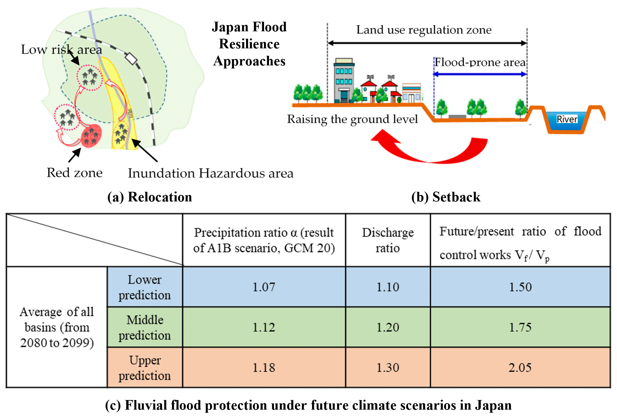
Figure 3Flood resilience approach in Japan for (a) relocation and (b) setback strategies to protect residents and (c) fluvial flood prediction with future climate projection (adopted from MILT, 2008, 2013; Fan and Huang, 2020).
“Flood Resilience” refers to the ability of communities and sectors to withstand a flood event and the ability to recover from the disruption of floods (Environmental Protection Agency, 2014). In Japan lately, the government especially tackled the perception via issuing flood hazard maps (MILT, 2008). The MILT was further concerned about the intensive rainstorms that enhanced urban floods and legislated specific measures to reduce flood risk during heavy rainstorms (MILT, 2013). After the tsunami and coastal floods in the early 2010s, the MILT further implemented the Act on Special Measures concerning Urban Reconstruction in 2018 to strengthen flood resilience, particularly tackling the prevention, emergency response, and recovery processes (see Fig. 3). This is used to support decision-making by land-use planners by setting up the land-use regulation zone system, directing the flood proofing of existing urban facilities (e.g. the underground, railways, public service facilities), raising flood awareness amongst the at-risk public (via flood warning systems, hazard maps, and future flood projection), and informing the emergency response and evacuation procedures (via relocation practice) of the civil emergency services (MILT, 2018).
3.1 Sustainable flood risk management (SFRM) – where are we now?
Sustainable flood risk management (SFRM) evolved during the 1990s, when the concept of sustainable development became prominent (Brundtland, 1987). The three pillars of sustainability (social, economic, environmental) are widely recognised, and they have influenced sustainability policies (UNCE, 1992). Sustainable development strategies seek to ensure economic development is conducted in a manner that respects environmental limits and values and considers the distribution of all costs and benefits of development through time (inter-generational equity) and across social groups (intra-generational equity) (Pearce et al., 1996; Sneddon and Fox, 2006; Morse, 2008). An additional imperative is the development of strategies through open and participatory mechanisms. These sustainability principles apply to all types of development, including the development of FRM strategies, through Sustainable FRM (SFRM) (Evans et al., 2004; Hooijer et al., 2004).
Table 2 illustrates how SFRM is interpreted differently across the four countries in this study and reveals that whilst SFRM is not a contested concept, it does lack a widely accepted definition. Similarly, De Bruijn et al. (2007) suggest that SFRM could be understood simply as the ability of society and ecosystems to cope with several types of flood risk whilst maintaining a certain level of well-being, whilst Chan et al. (2013b) attempt to characterise SFRM practice within a more explicit sustainability framework. Nevertheless, for the four countries we discussed above, progress from flood control to FRM and now towards SFRM is evident (Lawson et al., 2020) (see Fig. 4).
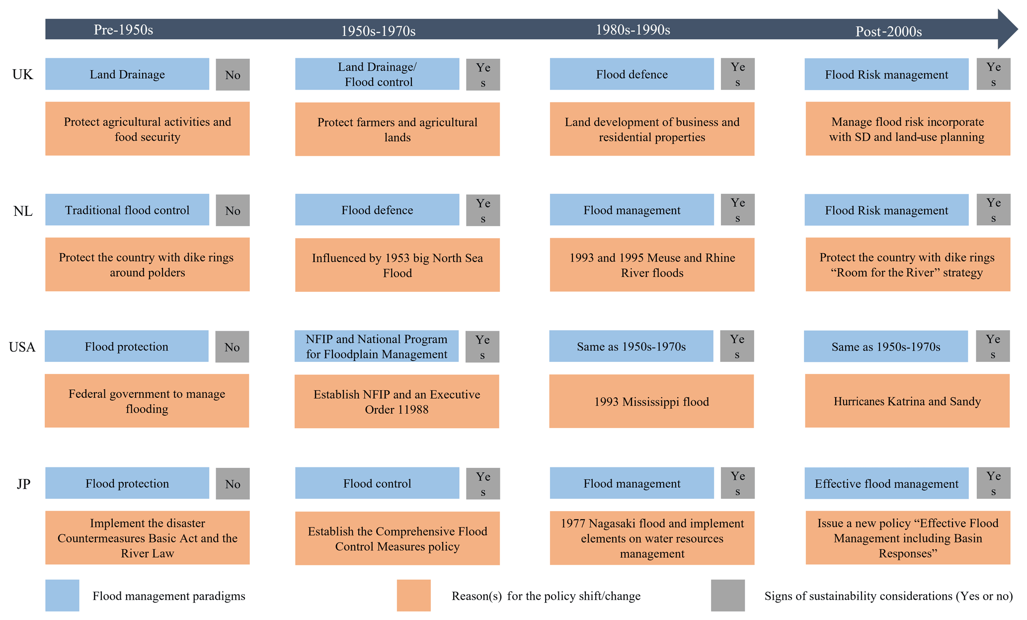
Table 2Strengths and weaknesses of current FRM practices towards SFRM across four countries. NL, JP, and NYC denote the Netherlands, Japan, and New York City respectively.
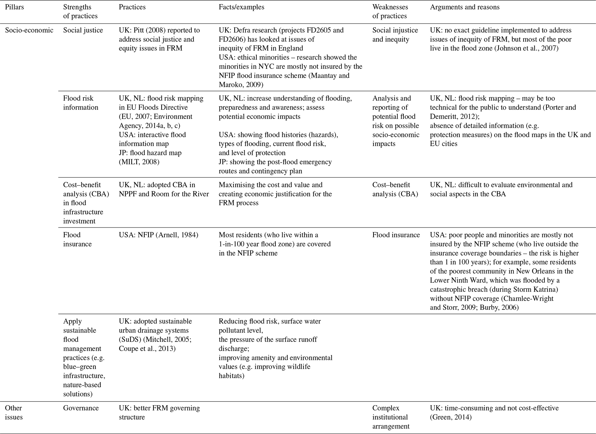
Examples of action taken towards SFRM include the open provision of flood risk information to aid participatory planning (post-2000), which has been implanted in the Netherlands and the UK; refer to the EU Floods Directive – 2007/60/EC (EU, 2007). For example, the local authorities (e.g. local planning and water bureaus) deal with flood mitigation measures that consider addressing wider socio-economic assessments and appraisals. The authorities extended the cost–benefit analysis and similar benchmarking practices that assess economic impacts, social values, perceptions and opinions, cost sharing through national flood insurance schemes, environmental considerations, natural capital, and design of flood mitigation with nature. Similarly, the United States also considered these factors during the same era, considered protecting the natural environment, and recognised the natural environment's value in mitigating flood risk (e.g. via sustainable drainage systems, wetlands, and reintroduction of river meanders) (Butler and Pidgeon, 2011; Green, 2014; Porter and Demeritt, 2012; Scott et al., 2013). From our review, it is apparent that no country has FRM that comprehensively addresses sustainability concerns (see Table 2).
For example, Maantay and Maroko (2009) show how in New York City, the national flood insurance scheme does not effectively reach some social groups, particularly ethnic minorities, who tend to be exposed to above-average flood risk. Social equity issues also tend to be underrepresented in SFRM studies, although researchers and practitioners are increasingly alert to how resilience to flooding varies spatially, temporally (Yang et al., 2021), and socially with low-income households a particular concern. Similarly, economic appraisal of flood strategies recognises environmental impacts, but ecosystem service values and the wider benefits of nature-based flood management (Dadson et al., 2017) are nowhere routine in such economic appraisal. Concerning flood management, the Pitt review into a series of major floods in England (Pitt, 2008) highlighted that flood governance can be a major problem. Pitt observed that so many organisations had responsibilities for FRM, at a variety of geographic scales and flood types, that a high degree of institutional complexity resulted which acted as a barrier to effective FRM. This problem is also seen in the USA (Rosenzweig and Solecki, 2014). Local authorities have since been given the lead role in FRM. Porter and Demeritt (2012) commend the openness and transparency of flood risk mapping but raise concerns over the degree of technical expertise needed for the public to understand and act appropriately on the information conveyed. These examples indicate that in the four countries reviewed in this paper, challenges to SFRM exist. However, these tend to be challenges of an operational rather than philosophical nature, challenging the delivery of SFRM but not the principle. That is, there is now widespread recognition of the need to address sustainability concerns and embed sustainability principles into FRM policy and practice.
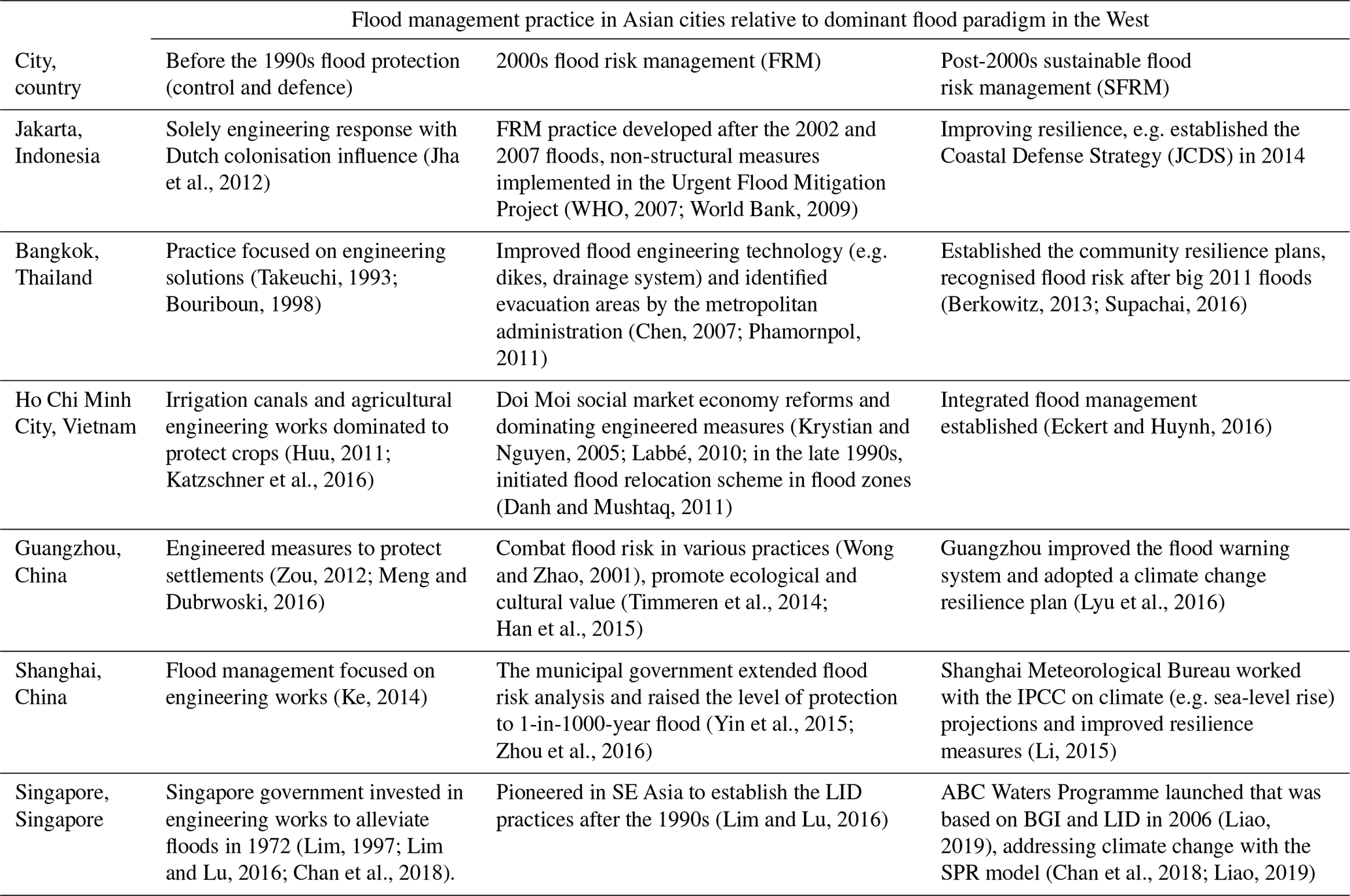
Table 3Development of flood management practices in selected E and SE Asian cities.
3.2 Implementing SFRM in Asian coastal megacities
Currently, many Asian coastal megacities are operating predominantly within the flood control and defence paradigms, including Guangzhou, Shenzhen, and Hong Kong (Chan et al., 2013a; Yang et al., 2018); Shanghai; Bangkok (Keokhumcheng et al., 2012); Ho Chi Minh City (Storch and Downes, 2011; Nguyen et al., 2021); Jakarta (Texier, 2008; Wannewitz and Garschagen, 2021); and Singapore (Chan et al., 2018, 2021, 2022). These cities all feature in the top coastal cities at risk by the 2050s (Hallegatte et al., 2013) because of not only their rapidly growing populations and economies and developmental pressure but also rising flood hazards from climate change (i.e. more frequent storms, intensive rainfall, etc.). Limited room to expand has resulted in the development of floodplains, wetlands, and reclaimed coastal areas (Chan et al., 2014; Ji et al., 2021), a practice common in Asian coastal cities (Fuchs et al., 2011). In Table 3, we illustrate the flood management practice in Asian cities relative to the dominant flood paradigm in the West. We discuss the progress of their flood management strategies as we start with the era before the 1990s – flood protection (control and defence) – and further discuss their progress in the 2000s flood risk management (FRM) era and post-2000s sustainable flood risk management (SFRM) era. We also discuss the evidence and examples for these practices among the selected Asian coastal cities further below in this section.
Looking at the past (before the 1990s), there are many coastal cities that have suffered from severe floods in Asia. Singapore is an example as it has developed rapidly with tremendous socio-economic growth but has been inundated by severe floods because of the rapid urbanisation since its independence in 1965 (Chan et al., 2018). The Drainage Department of Singapore was established in 1972 to prevent floods. The government of Singapore invested heavily in constructing dense networks of drains and canals as the major approach for flood management before the 1990s (Lim, 1997), and this reduced flood-prone areas from 6900 ha in the 1960s to 207 ha in the 1990s (Lim and Lu, 2016). Owing to economic development, Singapore adopted a low-impact development (LID) approach (similar to SuDS in the UK) in the 1990s in line with the changes made in other countries. This included constructing storm-water retention ponds for storm-water storage and reuse in the district of Kallang (Lim and Lu, 2016).
Indeed, cities near coasts such as Bangkok, Jakarta, and Ho Chi Minh City have also faced similar issues (on urban floods), particularly in their fast urbanisation and developmental period during the early 1980s. Rapid land-use changes transformed green spaces (e.g. agricultural and farmland, forest, wetland) into an urban area, but land drainage and flood measures were unable to cope with the urban runoff (Takeuchi, 1993; Jha et al., 2012; Huu, 2011; Katzschner et al., 2016). Mostly, the flood management practices before the 1990s in these cities were mainly driven by flood control and defence measures. Jakarta was under Dutch influence in terms of flood engineering in the early 1920s, which is demonstrated by the East Flood Canal Project, which was constructed during the Dutch colonial period in 1924 and which was an extension of the West Flood Canal at the city of Jakarta to alleviate urban peak discharge (Jha et al., 2012). Bangkok was dominated by engineering approaches such as engineering works for agricultural irrigation, embankments, reservoirs, and drainage systems in the 1980s and 1990s (Bouriboun, 1998). Across the Mekong, Ho Chi Min City was also dominated by agricultural engineering works for agricultural production (e.g. rice and poultry) and crop protection during the storms (e.g. typhoons) before the 1990s (Huu, 2011). Likewise, Chinese coastal cities faced urban floods that were enhanced by urbanisation and rapid development during the Open Door Policy established in the late 1970s, such as urban floods in Shanghai during 1981 and later events in 2020 and 2021 because of typhoons (Chan et al., 2021, 2022). Guangzhou experienced frequent urban floods due to increased population density in major areas such as Tianhe or Baiyun (Zou, 2012). Engineering approaches (e.g. flood walls, dikes, drainage canals, pumping stations, and dredging engineering works) were particularly popular and applicable before the 1990s in both cities (Zou, 2012; Meng and Dubrwoski, 2016).
During the 2000s, these coastal cities gradually moved to consider wider aspects of socio-economic risk and health issues in communities, and these have started to be considered in FRM policy implementation. For example, in Jakarta, the municipal authorities initiated non-structural measures including an early warning system, health service capacity building, and contingency planning including relocation and compensation schemes after the 2002 and 2007 floods, having realised that engineering works were insufficient (WHO, 2007; World Bank, 2009). In Bangkok, the Thai government still preferred using engineering works to further strengthen flood defence (e.g. dikes, drainage system, canals, and retention area) that not only focused on improving the engineering technology of flood mitigation but also established emergency response measures such as evacuation areas in Bangkok metropolitan districts (Chen, 2007; Phamornpol, 2011). In Ho Chi Minh City, socio-economic implementation (i.e. master development plans, investment plans) was initiated in the late 1980s. The Vietnamese authorities opted for rapid urban expansion and deforestation due to the pressure of economic growth. During that period, the authorities gave limited consideration to urban floods and relied on engineered measures for flood issues (Krystian and Nguyen, 2005), and later in the 1990s they started considering flood relocation and relocated over 1 million people away from frequent flood zones (Danh and Mushtaq, 2011).
Across China, taking account into Shanghai, for example, the authorities started to recognise a “risk-based” flood management strategy. FRM approach has been recognised as a step ahead as the municipality government has understood the importance of using “flood risk” analyses and information to evaluate the hazards and responses and measures (Lu, 2018). For example, the Shanghai authority acted to raise the flood protection level of coastal defence from a 1-in-100-year to 1-in-1000-year protection level during the early 2000s (Yin et al., 2015; Zhou et al., 2016). In Guangzhou, the municipality government similarly reacted after frequent floods in the late 1990s and adopted flood risk measures (Wong and Zhao, 2001). The authorities then promoted green infrastructure (e.g. via a “green–blue network” in Nansha District) to protect ecology and recognised cultural value by conservation of heritage against flood impacts (Timmeren et al., 2014; Han et al., 2015).
In the last 2 decades, these cities have experienced more floods, bringing greater urgency for governments to progress and consider wider socio-economic and environmental pillars in flood risk management whilst also being influenced by global FRM practices. For example, Jakarta established a comprehensive flood management plan that recognised higher risk (e.g. populations, flood locations) (JICA, 2013). The authority adopted land-use planning measures to avoid development increasing flood risk and implemented micro-insurance schemes and relocation contingency plans to improve resilience (Jha et al., 2012). Similarly, in Bangkok, the Thai government established a flood resilience strategy based on catchment management after the severe 2011 flood. This was the worst flood since 1942 with USD 46.5 billion of damage and 680 deaths (Poaponsakorn, 2015) and insurance losses solely from Japanese factories (e.g. Toyota, Honda, and Nissan) of USD 10 billion to 15 billion. This enhanced global insurers' and governments' understanding of the chain effect of large floods (Meehan, 2012). The government initiated a flood risk zoning policy and restricted developments in high-risk areas (Water Resource Management Strategic Committee, 2012; Berkowitz, 2013; Supachai, 2016). In Vietnam, the government have also established integrated flood management strategies (Eckert and Huynh, 2016), but the municipal governments still focus on engineered flood measures (Katzschner et al., 2016).
In China, Shanghai, and Guangzhou, governments have moved forward in alignment with the National Climate Change Strategy. For example, Guangzhou has followed the National 12th Five-Year Plan included a national adaptation strategy (NAS) for climate change (UNDP, 2012) and established a scientific warning system based on accurate flood risk information (Lyu et al., 2016). Shanghai was identified as one of the most vulnerable Chinese cities under climate change (Hallegatte et al., 2013; Francesch-Huidobro et al., 2017; Yuan et al., 2017). The city authority further established flood monitoring and forecast systems, and the meteorological office worked with the IPCC on climate projections to further improve public emergency warning, planning, and preparedness (Li, 2015). Singapore is transforming from a “City in a Garden” to a “City of Gardens and Water”. The government is also further implementing the Active, Beautiful, Clean (ABC) Waters Programme for delivering sustainable and climate-resilient measures on urban storm-water management and adopted the source–pathway–receptor (SPR) model to address flood risk and climate change (Chan et al., 2018; Liao, 2019).
Climate change is raising sea levels, making storm surges more hazardous (Nicholls, 2011), and is increasing the frequency, intensity, and magnitude of storms (typhoons), intense rainfall events, and sea surges (Basconcillo and Moon, 2021; Chan et al., 2021, 2022; Ku et al., 2019; Webster, 2008; Webster et al., 2005). Natural resource extraction is also increasing flood hazard through the land subsidence it causes; for example, in the coastal area of Bangkok groundwater extraction has resulted in subsidence of 2 m since 1970 (Syvitski et al., 2009). The cities that are selected in this review rely upon hard-engineering defences and their previous ways of dealing with flooding, but these structures offer a relatively low degree of protection (e.g. under 1 in 10 years). For example, the major urban drainage systems in Singapore have been improved from 1 in 50 years to 1 in 100 years, whilst Guangzhou and Shenzhen only have a 1-in-20-year return period protection against typhoon and sea surges (Chan et al., 2012, 2018). Further, fatalities occurred in Hong Kong in 2010 when pluvial flooding overwhelmed the 1-in-50-year protection level defences, whilst Shenzhen only has a 1-in-20-year return period protection against typhoons and sea surges (Chan et al., 2012).
Confronted with climate change, the existing levels of protection are not enough. There is an urgency to improve flood protection standards with heavier investment financially, but we also need to address social and environmental perspectives together to reduce future flood risk. With that in mind, it is sensible to encourage Asian coastal cities to move further towards SFRM. We have been using other global lessons and experiences (from four countries) that have indicated ways forward on flood management.
A key impetus of the shift in practice from flood protection and defence paradigms to SFRM has been a recognition that the costs of traditional hard-engineering flood defences are increasingly unaffordable and that a wider package of measures is needed to address flood risk. As learned in the aftermath of the Hurricane Katrina disaster in New Orleans, FRM also requires better development of non-engineered measures, ranging from strategic land-use planning with substantive public participation and specific attention to the most vulnerable communities (including insurance to aid recovery) (Chamlee-Wright and Storr, 2009; Burby, 2006) to well-prepared emergency and evacuation plans for when floods strike (Niedoroda et al., 2010). All of these should be considered through a multi-criteria decision analysis of alternative strategies). Experience with Hurricane Harvey in 2017 suggests that even if these lessons have been learned, flood risk may remain high due to a legacy effect of past land-use planning and investment decisions.
Hard-engineering flood protection measures will always be important in the defence of Asian cities, but whilst these defences can be more coherently planned (Francesch-Huidobro et al., 2017), evidence indicates that the level of protection needed is unaffordable (Jongman et al., 2014). Despite the apparent limitations of relying solely on structural defences, few efforts have yet been made to adopt a wider set of measures that incorporate non-structural protection measures, pre-emptive strategic and land-use planning, risk awareness and communication, emergency planning, and post-event recovery and learning.
Current approaches also tend to focus on potential economic losses, neglecting the role and value of the natural environment and social considerations, such as impacts and recovery potential of different social groups, and participatory planning. Indeed, most Asian cities (even those with high flood risk) remain focused on hard-engineering solutions (refer to Table 3) and lack a sufficient range of climate change adaptation guidance and practice (Nguyen et al., 2021), which may prove problematic as sea level rises and extreme storms, surges, and typhoons become more frequent. Given the lack of affordability of the level of engineered defences necessary to mitigate rising flood risk, Asian coastal megacities may find it advantageous to recognise the wider international experience and develop coping strategies that reflect a greater acceptance of options of living with flood risk rather than assume that all such risk can be engineered away. Such coping strategies combine traditional engineering, soft engineering (e.g. SuDS), land-use planning, working with rather than against nature, and social strategies that recognise vulnerable communities and engage stakeholders in the co-production of responses to flood risk. The international experience clearly shows that the SFRM approach is more complex than control or defend; hence significant operational and procedural challenges can be expected, with good governance needed to engage stakeholders effectively whilst avoiding undue institutional complexity.
In Asian coastal megacities, flood risk is high and rising, and defending against flooding effectively using traditional approaches is becoming financially unsustainable. Coping with flood risk, as illustrated by Room for the River concepts and through “soft measures”, as discussed above, is in some countries increasingly considered a necessary and more sustainable alternative to hard-engineering defences alone.
The policies in four countries as case studies demonstrate important lessons for achieving long-term SFRM to deliver flood management practices consistent with socio-economic and environmental concerns. We accept that different countries and cities have their interpretation of SFRM but recommend that policymakers adopt mixed options for long-term sustainability with social, economic, and environmental considerations.
However, this is a philosophy that has had relatively little influence on practice in the coastal megacities of Asia. There is, of course, no prescriptive template for developing coping strategies, and each country and city will need and wish to develop measures appropriate to their specific contexts – physical, socio-economic, environmental, and cultural. Specific local knowledge (i.e. circumstances, contexts, and constraints) in Asian coastal cities/megacities will need to be considered.
For very dense coastal megacities “making space for water” opportunities may be rather more limited than they are elsewhere in the world, with coping strategies developing different emphases, and we are not trying to make this ground for urban or rural areas, with even urban areas re-considering their long-term land-use planning (i.e. master plans) for coping with the climate extremes and nature. Once the limitations of hard-engineering defences are recognised and understood, sustainable development principles and tools can be used to shape coping strategies and help deliver more flood-resilient cities.
No data sets were used in this article.
All authors contributed to the study design and to the manuscript. All authors read and approved the final manuscript. FKSC contributed as the first author, developing the idea and writing the first draft of the manuscript. LEY and XL contributed to the general design of the study and the manuscript and joined FKSC as joint correspondence authors. Other all co-authors – GM, NW, MG, ZW, BM, and OA – contributed to the review of and edits to the concept, theory, and storyline (including the discussion and conclusion) of this manuscript.
The contact author has declared that none of the authors has any competing interests.
Publisher's note: Copernicus Publications remains neutral with regard to jurisdictional claims in published maps and institutional affiliations.
This article is part of the special issue “Future risk and adaptation in coastal cities”. It is not associated with a conference.
We especially thank the handling editor and the anonymous reviewers for their contributions and inputs to this manuscript.
This research has been supported by the National Key Research and Development Program of China (grant no. 2019YFC1510400s) and the National Natural Science Foundation of China (grant no. 41850410497).
This paper was edited by Animesh Gain and reviewed by three anonymous referees.
Aerts, J. C. J. H., Lin, N., Botzen, W., Emanuel, K., and de Moel, H.: Low-Probability Flood Risk Modeling for New York City, Risk Anal., 33, 772–788, https://doi.org/10.1111/risa.12008, 2013.
Arnell, N. W.: Flood hazard management in the United States and the National Flood Insurance Program, Geoforum, 15, 525–542, https://doi.org/10.1016/0016-7185(84)90023-X, 1984.
Ashley, R., Gersonius, B., and Horton, B.: Managing flooding: from a problem to an opportunity, Philos. T. Roy. Soc. A, 378, 2169, https://doi.org/10.1098/rsta.2019.0214, 2020.
Bagstad, K. J., Stapleton, K., and D'Agostino, J. R.: Taxes, subsidies, and insurance as drivers of United States coastal development, Ecol. Econ., 63, 285–298, https://doi.org/10.1016/j.ecolecon.2006.09.019, 2007.
Ball, T., Werritty, A., and Geddes, A.: Insurance and sustainability in flood-risk management: the UK in a transitional state, Area, 45, 266–272, https://doi.org/10.1111/area.12038, 2013.
Basconcillo, J. and Moon, I.-J.: Recent increase in the occurrences of Christmas typhoons in the Western North Pacific, Scient. Rep., 11, 7416, https://doi.org/10.1038/s41598-021-86814-x, 2021.
Beck, S.: Between Tribalism and Trust: The IPCC Under the “Public Microscope”, Nat. Cult., 7, 151–173, https://doi.org/10.3167/nc.2012.070203, 2012.
Berke, P. R.: Why is Houston so vulnerable to devastating floods?. BBC News, https://www.bbc.com/news/world-us-canada-41107049 (last access: 5 August 2019), 2017.
Berkowitz, M.: 100 Resilient Cities, http://lghttp.60358.nexcesscdn.net/8046264/images/page/-/100rc/pdfs/Bangkok_-_Resilience_Strategy.pdf (lsat access: 21 August 2017), 2013.
Böhm, H. R., Haupter, B., Heiland, P., and Dapp, K.: Implementation of flood risk management measures into spatial plans and policies, River Res. Appl., 20, 255–267, https://doi.org/10.1002/rra.776, 2004.
Bouriboun, S.: Food and Agriculture Organization. Flood management and mitigation in the Mekong River Basin, http://www.fao.org/docrep/004/ac146e/AC146E01.htm (last access: 20 August 2017), 1998.
Brown, J. D. and Damery, S. L.: Managing flood risk in the UK: towards an integration of social and technical perspectives, T. Inst. Brit. Geogr., 27, 412–426, https://doi.org/10.1111/1475-5661.00063, 2002.
Brundtland, G. H.: Our common future – Call for action, Environ. Conserv., 14, 291–294, https://doi.org/10.1017/S0376892900016805, 1987.
Burby, R. J.: Hurricane Katrina and the paradoxes of government disaster policy: Bringing about wise governmental decisions for hazardous areas, Ann. Am. Acad. Polit. Social Sci., 604, 171–191, https://doi.org/10.1177/0002716205284676, 2006.
Bureau of Meteorology: What is a Tropical Cyclone?, Bureau of Meteorology, Melbourne, Australia, http://www.bom.gov.au/other/accessibility.shtml?ref=ftr, last access: 12 December 2021.
Burgess, K., Jay, H., Nicholls, R. J., Green, C., and Penning-Rowsell, E. C.: Assessment of future coastal erosion risk, Thomas Telford, ISBN 9780727734495, 2007.
Butler, C. and Pidgeon, N.: From `flood defence' to `flood risk management': exploring governance, responsibility, and blame, Environ. Plan. C, 29, 533–547, https://doi.org/10.1068/c09181j, 2011.
Chamlee-Wright, E. and Storr, V. H.: “There's no place like New Orleans”: a sense of place and community recovery in the Ninth Ward after Hurricane Katrina, J. Urban Affair., 31, 615–634, https://doi.org/10.1111/j.1467-9906.2009.00479.x, 2009.
Chan, F., Mitchell, G., and McDonald, A. T.: Flood risk appraisal and management in mega-cities: a case study of practice in the Pearl River Delta, China, Water Pract. Technol., 7, 1–9, https://doi.org/10.2166/wpt.2012.060, 2012.
Chan, F., Adekola, O., Ng, C., Mitchell, G., and McDonald, A.: Coastal Flood-Risk Management Practice in Tai O, a Town in Hong Kong, Environ. Pract., 15, 1–19, https://doi.org/10.1017/S1466046613000215, 2013a.
Chan, F., Mitchell, G., Cheng, X., Adekola, O., and McDonald, A.: Developing a Sustainable Flood Risk Appraisal (SFRA) Framework for the Pearl River Delta, Environ. Urbaniz. Asia, 4, 301–323, https://doi.org/10.1177/0975425313510770, 2013b.
Chan, F., Wright, N., Cheng, X., and Griffiths, J.: After Sandy: Rethinking Flood Risk Management in Asian Coastal Megacities, Nat. Hazards Rev., 15, 101–103, 2014.
Chan, F., Joon, C. C., Ziegler, A., Dabrowski, M., and Varis, O.: Towards resilient flood risk management for Asian coastal cities: lessons learned from Hong Kong and Singapore, J. Clean. Product., 187, 576–589, https://doi.org/10.1016/j.jclepro.2018.03.217, 2018.
Chan, F., Yang, L.E., Scheffran, J., Mitchell, G., Adekola, O., Griffiths, J., Chen, Y., Li, G., Lu, X., Qi, Y., Li, L., Zheng, H., and McDonald, A.: Urban flood risks and emerging challenges in a Chinese delta: The case of the Pearl River Delta, Environ. Sci. Policy, 122, 101–115, https://doi.org/10.1016/j.envsci.2021.04.009, 2021.
Chan, F., Gu, X., Qi, Y., Thadani, D., Chen, Y. D., Lu, X., Li, L., Griffiths, J., Zhu, F., Li, J., and Chen, W. Y.: Lessons learnt from Typhoons Fitow and In-Fa: implications for improving urban flood resilience in Asian Coastal Cities, Nat. Hazards, 110, 2397–2404, https://doi.org/10.1007/s11069-021-05030-y, 2022.
Changnon, S. A.: The Historical Struggle with Floods on the Mississippi River Basin – Impacts of Recent Floods and Lessons for Future Flood Management and Policy, Water Int., 23, 263–271, https://doi.org/10.1080/02508069808686781, 1998.
Chen, P.: Flood impact assessment using hydrodynamic modelling in Bangkok, Thailand, Technical Report, International Institute for Geo, https://webapps.itc.utwente.nl/librarywww/papers_2007/msc/gem/pengyu.pdf (last access: 1 June 2021), 2007.
Coupe, S. J., Faraj, A. S., Nnadi, E. O., and Charlesworth, S. M.: Integrated Sustainable Urban Drainage Systems, Water Efficiency in Buildings: Theory and Practice, Geology, 328, 147–163, 2013.
Crichton, D.: Towards a Comparison of Public and Private Insurance Responses to Flooding Risks, Int. J. Water Resour. Dev., 24, 583–592, https://doi.org/10.1080/07900620801923161, 2008.
Dadson, S. J., Hall, J. W., Murgatroyd, A., Acreman, M., Bates, P., Beven, K., Heathwaite, L., Holden, J., Holman, I. P., Lane, S. N., and O'Connell, E. M.: A restatement of the natural science evidence concerning catchment-based `natural' flood management in the UK, P. Roy. Soc. A, 473, 20160706, https://doi.org/10.1098/rspa.2016.0706, 2017.
Danh, V. T. and Mushtaq, S.: Living with floods: an evaluation of the resettlement program of the Mekong Delta of Vietnam, in: Environmental change and agricultural sustainability in the Mekong Delta, Springer, 181–204, https://doi.org/10.1007/978-94-007-0934-8_11, 2011.
DCLG: Development and Flood Risk: A practice guide companion to PPS25 `Living Draft', Crown Copyright London, https://www.thenbs.com/PublicationIndex/documents/details?Pub=DCLG&DocID=281569 (last access: 2 July 2021), 2007.
DCLG: National Planning Policy Framework, Crown Copyright London, https://assets.publishing.service.gov.uk/government/uploads/system/uploads/attachment_data/file/1005759/NPPF_July_2021.pdf (last access: 2 July 2021), 2012.
De Bruijn, K. M., Green, C., Johnson, C., McFadden, I., Begum, S., and Stive, M. J. F.: Flood risk management in Europe. Innovation in policy and practice, Springer, the Netherlands, ISBN 978-1-4020-4199-0 (HB), 2007.
Defra: Making Space for Water: Taking Forward a New Government Strategy for Flood & Coastal Erosion Risk Management Encouraging and Incentivising Increased Resilience to Flooding, https://flooding.london/jrp/mswdp.pdf (last access: 31 July 2021), 2007.
Defra: Surface Water Management Plan Technical Guidance, https://assets.publishing.service.gov.uk/government/uploads/system/uploads/attachment_data/file/69342/pb13546-swmp-guidance-100319.pdf (last access: 2 July 2021), 2010.
Eckert, R. and Huynh, L. H. C.: Climate Responsive Neighbourhoods for HCMC: Compact City vs. Urban Landscape, in: Sustainable Ho Chi Minh City: Climate Policies for Emerging Mega Cities, Springer International Publishing, ISBN 978-3-319-04614-3, 2016.
Environment Agency.: Flood risk mapping from Rivers and Sea, Environment Agency, London, UK, https://www.gov.uk/check-flooding (last access: 31 July 2021), 2014a.
Environment Agency.: Live Flood Warning Map, Environment Agency, London, UK, https://check-for-flooding.service.gov.uk/ (last access: 31 July 2021), 2014b.
Environment Agency.: Risk of Flooding from Surface Water, Environment Agency, London, UK, https://www.gov.uk/government/news/surface-water-the-biggest-flood-risk-of-all (last access: 31 July 2021), 2014c.
Environmental Protection Agency: Flood Resilience – A Basic Guide for Water and Wastewater Utilities, Office of Water, USA, https://www.epa.gov/sites/default/files/2015-08/documents/flood_resilience_guide.pdf (last access: 13 May 2021), 2014.
EU – European Parliament: Directive 2007/60/EC of the European Parliament and of the Council of 23 October 2007 on the assessment and management of flood risks (Text with EEA relevance), https://eur-lex.europa.eu/legal-content/EN/TXT/?uri=CELEX:32007L0060 (last access: 14 May 2021), 2007.
Evans, E., Hall, J., Penning-Rowsell, E., Sayers, P., Thorne, C., Watkinson, A.: Future flood risk management in the UK, Water Manage., 159, 53–61, https://doi.org/10.1680/wama.2006.159.1.53, 2006.
Evans, E. P., Ashley, R., Hall, J. W., Penning-Rowsell, E. P., Saul, A., Sayers, P. B., Thorne, C. R., and Watkinson, A.: Foresight Future Flooding, Scientific Summary, in: Volume 1: Future Risks and their Drivers, https://www.thenbs.com/PublicationIndex/documents/details?Pub=DTI&DocID=304103 (last access: 5 April 2021), 2004.
Fan, J. and Huang, G.: Evaluation of Flood Risk Management in Japan through a Recent Case, Sustainability, 12, 5357, https://doi.org/10.3390/su12135357, 2020.
Fleming, G.: How can we learn to live with rivers? The findings of the Institution of Civil Engineers Presidential Commission on flood-risk management, Philos. T. Roy. Soc. A, 360, 1527–1530, https://doi.org/10.1098/rsta.2002.1014, 2002.
Francesch-Huidobro, M., Dabrowski, M., Tai, Y., Chan, F., and Stead, D.: Governance challenges of flood-prone delta cities: integrating flood risk management and climate change in spatial planning, Progr. Plan., 114, 1–27, https://doi.org/10.1016/j.progress.2015.11.001, 2017.
Fuchs, R., Conran, M., and Louis, E.: Climate Change and Asia's Coastal Urban Cities: Can They Meet the Challenge?, Environ. Urbaniz. Asia, 2, 13–28, https://doi.org/10.1177/097542531000200103, 2011.
Fujita, M. and Hamaguchi, N.: Japan and economic integration in East Asia: post-disaster scenario, Ann. Reg. Sci., 48, 485–500, https://doi.org/10.1007/s00168-011-0484-y, 2012.
Galloway, G. E., Balabanis, P., Bronstert, A., Casale, R., and Samuels, P.: In Ribamod, River Basin Modeling, Management and Flood Mitigation, Concerted Action, HR Wallingford, https://eprints.hrwallingford.com/431/1/SR551.pdf (last access: 18 July 2021), 1999.
Gerritsen, H.: What happened in 1953? The Big Flood in the Netherlands in retrospect, Philos. T. Roy. Soc. A, 363, 1271–1291, https://doi.org/10.1098/rsta.2005.1568, 2005.
Green, C.: Competent authorities for the flood risk management plan – reflections on flood and spatial planning in England, J. Flood Risk Manage., 10, 195–204, https://doi.org/10.1111/jfr3.12097, 2014.
Green, C. H., Tunstall, S. M., and Fordham, M. H.: The Risks from Flooding: Which Risks and Whose Perception?, Disasters, 15, 227–236, https://doi.org/10.1111/j.1467-7717.1991.tb00456.x, 1991.
Hall, J. W., Evans, E. P., Penning-Rowsell, E. C., Sayers, P. B., Thorne, C. R., and Saul, A. J.: Quantified scenarios analysis of drivers and impacts of changing flood risk in England and Wales: 2030–2100, Environ. Hazards, 5, 51–65, 2003.
Hallegatte, S., Green, C., Nicholls, R. J., and Corfeemorlot, J.: Future flood losses in major coastal cities, Nat. Clim. Change, 3, 802–806, 2013.
Hamin, E. M., Abunnasr, Y., and Ryan, R. L.: Planning for climate change: a reader in green infrastructure and sustainable design for resilient cities, Routledge, New York, NY, ISBN 978-0-8153-9167-8(hbk), 2019.
Han, J., Pan, H., Zhang, G., and Sun, H.: Innovative Practice of Green Infrastructure Planning – Example as Guangzhou Nansha New Distract Mingzhu Bay Core Distract, Construct. Technol., 16, 47–50, 2015.
Hanson, S., Nicholls, R., Ranger, N., Hallegatte, S., Corfee-Morlot, J., Herweijer, C., and Chateau, J.: A global ranking of port cities with high exposure to climate extremes, Climatic Change, 104, 89–111, 2011.
Hey, R. D., Heritage, G. L., and Patteson, M.: Impact of flood alleviation schemes on aquatic macrophytes, Wiley Online Library, 103–119, https://doi.org/10.1002/rrr.3450090204, 1994.
Hooijer, A., Klijn, F., Pedroli, G. B. M., and Van Os, A. G.: Towards sustainable flood risk management in the Rhine and Meuse river basins: synopsis of the findings of IRMA-SPONGE, River Res. Appl., 20, 343–357, 2004.
Huang, G.: A Comparative Study on Flood Management in China and Japan, Water, 6, 2821–2829, https://doi.org/10.3390/w6092821, 2014.
Hudson, P. F., Middelkoop, H., and Stouthamer, E.: Flood management along the Lower Mississippi and Rhine Rivers (The Netherlands) and the continuum of geomorphic adjustment, Geomorphology, 101, 209–236, https://doi.org/10.1016/j.geomorph.2008.07.001, 2008.
Hulme, M., Jenkins, G. J., Lu, X., Turnpenny, J. R., Mitchell, T. D., Jones, R. G., Lowe, J., Murphy, J. M., Hassell, D., Boorman, P., McDonald, R., and Hill, S.: Climate Change Scenarios for the United Kingdom: The UKCIP02 Scientific Report, ISBN 0-902170-60-0, 2002.
Huu, P. C.: Planning and implementation of the dyke systems in the Mekong delta, Vietnam, Pedobiologia, 54, 217–224, 2011.
Ikeda, S., Sato, T., and Fukuzono, T.: Towards an integrated management framework for emerging disaster risks in Japan, Nat. Hazards, 44, 267–280, 2008.
Janssen, J. A. E. B.: On peaks and politics; governance analysis of flood risk management cooperation between Germany and the Netherlands, Int. J. River Basin Manage., 6, 349–355, https://doi.org/10.1080/15715124.2008.9635362, 2008.
Jha, A. K., Bloch, R., and Lamond, J.: Cities and Flooding: A Guide to Integrated Urban Flood Risk Management for the 21st Century, The World Bank, Washington, DC, https://openknowledge.worldbank.org/handle/10986/2241 (last access: 20 June 2021), 2012.
Ji, T., Wei, H. H., Sim, T., Yang, L. E., and Scheffran, J.: Disaggregated validation of disaster-resilience indicators using household survey data: A case study of Hong Kong, Sustain. Cities Soci., 67, 102726, https://doi.org/10.1016/j.scs.2021.102726, 2021.
JICA – Japan International Cooperation Agency: The project for capacity development of Jakarta Comprehensive Flood Management in Indonesia technical cooperation report comprehensive flood management plan, https://openjicareport.jica.go.jp/pdf/12127122_02.pdf (last access: 20 June 2021), 2013.
Johnson, C., Penning-Rowsell, E., and Parker, D.: Natural and imposed injustices: the challenges in implementing `fair' flood risk management policy in England, Geogr. J., 173, 374–390, https://doi.org/10.1111/j.1475-4959.2007.00256.x, 2007.
Johnson, C. L. and Priest, S. J.: Flood Risk Management in England: A Changing Landscape of Risk Responsibility?, Int. J. Water Resour. Dev., 24, 513–525, 2008.
Jongman, B., Koks, E .E., Husby, T. G., and Ward, P. J.: Increasing flood exposure in the Netherlands: implications for risk financing, Nat. Hazards Earth Syst. Sci., 14, 1245–1255, https://doi.org/10.5194/nhess-14-1245-2014, 2014.
Jorissen, R., Kraaij, E., and Tromp, E.: Dutch flood protection policy and measures based on risk assessment, E3S Web of Conferences, 7, 20016, https://doi.org/10.1051/e3sconf/20160720016, 2016.
Katzschner, A., Waibel, M., Schwede, D., Katzschner, L., Schmidt, M., and Storch, H.: Sustainable Ho Chi Minh City: Climate Policies for Emerging Mega Cities, Springer International Publishing, Switzerland, ISBN 978-3-319-04614-3, 2016.
Ke, Q. Flood risk analysis for metropolitan areas – a case study for shanghai, Civil Engineering & Geosciences, PhD thesis, Delft University of Technology, Delft, the Netherlands, ISBN 9789065623669, 2014.
Keokhumcheng, Y., Tingsanchali, T., and Clemente, R. S.: Flood risk assessment in the region surrounding the Bangkok Suvarnabhumi Airport, Water Int., 37, 201–217, https://doi.org/10.1080/02508060.2012.687868, 2012.
Klijn, F., Van Buuren, M., and Van Rooij, S. A. M.: Flood-risk management strategies for an uncertain future: Living with rhine river floods in the Netherlands?, Ambio, 33, 141–147, https://doi.org/10.1579/0044-7447-33.3.141, 2004.
Klijn, F., Samuels, P., and Van Os, A.: Towards flood risk management in the EU: State of affairs with examples from various European countries, Int. J. River Basin Manage., 6, 307–321, https://doi.org/10.1080/15715124.2008.9635358, 2008.
Kreienkamp, F., Philip, S. Y., Tradowsky, J. S., Kew, S. F., Lorenz, P., Arrighi, J., Belleflamme, A., Bettmann, T., Caluwaerts, S., Chan, S. C., Ciavarella, A., Cruz, L. D., Vries, H, D., Demuth, N., Ferrone, A., Ferrone, E, M., Fowler, H, J., Goergen, K., Heinrich, D., Henrichs, Y., Lenderink, G., Kaspar, F., Nilson, E., Otto, F., Ragone, F., Seneviratne, S, I., Singh, R, K., Skålevåg, A., Termonia, P., Termonia, L., Aalst, M., Bergh, J, V., Bergh, H, V., Vannitsem, S., Oldenborgh, G, J., Schaeybroeck, B, V., Vautard, R., Vonk, D., and Wanders, N.: Rapid attribution of heavy rainfall events leading to the severe flooding in Western Europe during July 2021, World Weather Attribution, https://www.worldweatherattribution.org/wp-content/uploads/Scientific-report-Western-Europe-floods-2021-attribution.pdf, last access: 8 August 2021.
Krystian, W. P. and Nguyen, S. N.: Experience and practices on flood control in Vietnam, Water Int., 30, 114–122, https://doi.org/10.1080/02508060508691843, 2005.
Kotz, M., Levermann, A., and Wenz, L.: The effect of rainfall changes on economic production, Nature, 601, 223–227, https://doi.org/10.1038/s41586-021-04283-8, 2022.
Ku, H., Maeng, J. H., and Cho, K.: Climate change impact on typhoon-induced surges and wind field in coastal region of South Korea, J. Wind Eng. Indust. Aerodynam., 190, 112–118, 2019.
Kundzewicz, Z. W.: Flood protection – sustainability issues, Hydrolog. Sci. J., 44, 559–571, https://doi.org/10.1080/02626669909492252, 1999.
Kundzewicz, Z. W. and Takeuchi, K.: Flood protection and management: quo vadimus?, Hydrolog. Sci. J., 44, 417–432, https://doi.org/10.1080/02626669909492237, 1999.
Kundzewicz, Z. W., Budhakooncharoen, S., Bronstert, A., Hoff, H., Lettenmaier, D., Menzel, L., and Schulze, R.: Coping with variability and change: Floods and droughts, Nat. Resour. Forum, 26, 263–274, https://doi.org/10.1111/1477-8947.00029, 2002.
Lamond, J. and Penning-Rowsell, E.: The robustness of flood insurance regimes given changing risk resulting from climate change, Clim. Risk Manage., 2, 1–10, 2014.
Lawson, E., Farmani, R., Woodley, E., and Butler, D.: A Resilient and Sustainable Water Sector: Barriers to the Operationalisation of Resilience, Sustainability, 12, 1797, https://doi.org/10.3390/su12051797, 2020.
Li, Y.: Protection of shanghai from flooding, MS thesis, Delft University of Technology, Delft, the Netherlands, https://citeseerx.ist.psu.edu/viewdoc/download?doi=10.1.1.874.5218&rep=rep1&type=pdf (last access: 1 March 2021), 2015.
Liao, K. H.: The socio-ecological practice of building blue-green infrastructure in high-density cities: what does the ABC Waters Program in Singapore tell us?, Socio-Ecol. Pract. Res., 1, 67–81, 2019.
Lim, H. S. and Lu, X. X.: Sustainable urban stormwater management in the tropics: An evaluation of Singapore's ABC Waters Program, J. Hydrol., 538, 842–862, https://doi.org/10.1016/j.jhydrol.2016.04.063, 2016.
Lim, M. C.: Drainage planning and control in the urban environment: The Singapore experience, Environ. Monit. Assess., 44, 183–197, 1997.
Link, L. E.: The anatomy of a disaster, an overview of Hurricane Katrina and New Orleans, Ocean Eng., 37, 4–12, https://doi.org/10.1016/j.oceaneng.2009.09.002, 2010.
Lo, A. Y. and Chan, F. K. S.: Preparing for flooding in England and Wales: the role of risk perception and the social context in driving individual action, Springer, 1–21, https://doi.org/10.1007/s11069-017-2870-y, 2017.
Longenecker, G.: HAZUS-MH Coastal Flood Module: FEMA Region IV Standard Operating Procedure For Coastal Flood Hazard & Loss Analysis, https://www.fema.gov/flood-maps/products-tools/hazus (last access: 31 July 2021), 2008.
Lu, Y.: Impacts of Climate Change on Shanghai Flood Prevention, Shanghai Water Engineering Design & Research Institute, https://www.atse.org.au/Documents/International Colloboration/Workshops/Aust China Science and Tech/Climate Change/Yongjin.pdf (last access: 23 August 2017), 2010.
Lumbroso, D., Stone, K., and Vinet, F.: An assessment of flood emergency plans in England and Wales, France and the Netherlands, Nat. Hazards, 58, 341–363, 2011.
Lyu, H. M., Wang, G. F., Shen, J., Lu, L. H., and Wang, G. Q.: Analysis and GIS mapping of flooding hazards on 10 May 2016, Guangzhou, China, Water, 8, 447, https://doi.org/10.3390/w8100447, 2016.
Maantay, J. and Maroko, A.: Mapping urban risk: Flood hazards, race, & environmental justice in New York, Appl. Geogr., 29, 111–124, https://doi.org/10.1016/j.apgeog.2008.08.002, 2009.
Meehan, R.: Thailand Floods 2011: Causes and Prospects from an Insurance Perspective, Stanford University Footnotes 17, Stanford University, Stanford, USA, http://web.stanford.edu/~meehan/floodthai2011/FloodNotes17.pdf (last access: 2 March 2021), 2012.
Meehl, G. A., Covey, C., Taylor, K. E., Delworth, T., Stouffer, R. J., Latif, M., McAvaney, B., and Mitchell, J. F. B.: The WCRP CMIP3 multimodel dataset: A new era in climate change research, B. Am. Meteorol. Soc., 88, 1383–1394, https://doi.org/10.1175/BAMS-88-9-1383, 2007.
Meng, M. and Dubrwoski, M.: The governance of flood risk planning in Guangzhou, China: using the past to study the present, International Planning History Society Proceedings, Delft University of Technology, the Netherlands, https://doi.org/10.7480/iphs.2016.3.1270, 2016.
Michel-Kerjan, E. and Kunreuther, H.: Redesigning Flood Insurance, Science, 333, 408–409, https://doi.org/10.1126/science.1202616, 2011.
MLIT: Kasen Kankyo no Seibi, Hozen no Torikumi [An approach to the maintenance and keep up of river environments], in: Ministry of Land, I., Transport and Tourism, Tokyo, 2008.
MLIT: 100 mm/h Safety Plan, https://www.mlit.go.jp/common/001011616.pdf (last access: 1 August 2021), 2013.
MILT: The 2018 amendment of the Act on Special Measures concerning Urban Reconstruction, http://www.mlit.go.jp/toshi/common/001283640.pdf (last access: 1 July 2021), 2018.
Mitchell, G.: Mapping hazard from urban non-point pollution: a screening model to support sustainable urban drainage planning, J. Environ. Manage., 74, 1–9, https://doi.org/10.1016/j.jenvman.2004.08.002, 2005.
Morse, S.: Post-sustainable development, Sustain. Dev., 16, 341–352, https://doi.org/10.1002/sd.354, 2008.
National Association of Insurance Commissioners and the Center for Insurance Policy and Research.: Flood Risk and Insurance, https://www.naic.org/documents/cipr_study_1704_flood_risk.pdf (last access: 5 August 2019), 2017.
National Weather Service: Weather-Related Fatality and Injury Statistics, https://www.weather.gov/hazstats (last access: 5 August 2019), 2018.
Nguyen, M. T., Sebesvari, Z., Souvignet, M., Bachofer, F., Braun, A., Garschagen, M., Schinkel, U., Yang, L. E., Nguyen, L. H., Hochschild, V., Assmann, A., and Hagenlocher, M.: Understanding and assessing flood risk in Vietnam: Current status, persisting gaps, and future directions, J. Flood Risk Manage., 14, e12689, https://doi.org/10.1111/jfr3.12689, 2021.
Nicholls, R. J.: Planning for the impacts of sea-level rise, Oceanography, 24, 144–157, 2011.
Niedoroda, A. W., Resio, D. T., Toro, G. R., Divoky, D., Das, H. S., and Reed, C. W.: Analysis of the coastal Mississippi storm surge hazard, Ocean Eng., 37, 82–90, https://doi.org/10.1016/j.oceaneng.2009.08.019, 2010.
NOAA – National Oceanic and Atmospheric Administration.: 2018's Billion Dollar Disasters in Context, https://www.climate.gov/news-features/blogs/beyond-data/2018s-billion-dollar-disasters-context, last access: 5 August 2019.
OECD: OECD Studies in Risk Management Japan-Floods, https://www.oecd.org/japan/37378001.pdf (last acess: 1 July 2021), 2006.
Parker, D. and Fordham, M.: An evaluation of flood forecasting, warning and response systems in the European Union, Water Resour. Manage., 10, 279–302, 1996.
Pearce, D., Hamilton, K., and Atkinson, G.: Measuring sustainable development: progress on indicators, in: Cambridge Journals Online, Cambridge University Press, 85–101, https://doi.org/10.1017/S1355770X00000395, 1996.
Penning-Rowsell, E., Johnson, C., and Tunstall, S.: `Signals' from pre-crisis discourse: Lessons from UK flooding for global environmental policy change?, Global Environ. Change, 16, 323–339, https://doi.org/10.1016/j.gloenvcha.2006.01.006, 2006.
Penning-Rowsell, E. C. and Chatterton, J. B.: The Benefits of Flood Alleviation: A Manual of Assessment Techniques (The Blue Manual), Saxon House, Farnborough, UK, ISBN 056600190X 9780566001901, 1977.
Penning-Rowsell, E. C. and Green, C.: New Insights into the Appraisal of Flood-Alleviation Benefits: (1) Flood Damage and Flood Loss Information, Water Environ. J., 14, 347–353, https://doi.org/10.1111/j.1747-6593.2000.tb00272.x, 2000.
Phamornpol, K.: Flood Mitigation and Management in Bangkok Metropolitan Area, Department of Drainage and Sewerage Bangkok Metropolitan Administration, http://www.unescap.org/sites/default/files/S3b4_Thailand.pdf (last access: 23 August 2017), 2011.
Pitt, M.: Learning lessons from the 2007 floods, Final Report, The Cabinet Office, London, UK, http://cip.management.dal.ca/publications/Pitt Review.pdf (last access: 20 June 2021), 2008.
Plate, E. J.: Flood risk and flood management, J. Hydrol., 267, 2–11, https://doi.org/10.1016/S0022-1694(02)00135-X, 2002.
Poaponsakorn, N., Meethom, P., and Pantakua, K.: The Impact of the 2011 Floods, and Flood Management on Thai Households, in: Resilience and Recovery in Asian Disasters, Springer, Japan, https://doi.org/0.1007/978-4-431-55022-8_5, 2015.
Porter, J. and Demeritt, D.: Flood-risk management, mapping, and planning: theÿinstitutional politics of decision support in England, Environ. Plan. A, 44, 2359–2378, https://doi.org/10.1068/a44660, 2012.
Rosenzweig, C. and Solecki, W.: Hurricane Sandy and adaptation pathways in New York: Lessons from a first-responder city, Global Environ. Change, 28, 395–408, https://doi.org/10.1016/j.gloenvcha.2014.05.003, 2014.
Samuels, P.: A European perspective on current challenges in the analysis of iland flood risks, in: Flood risk management: hazards, vulnerability and mitigation measures, Springer, 21–34, https://doi.org/10.1007/978-1-4020-4598-1_2, 2006.
Schanze, J.: Flood risk management – a basic framework In Flood risk management: hazards, vulnerability and mitigation measures, Springer, 1–20, https://doi.org/10.1007/978-1-4020-4598-1_1, 2006.
Schanze, J., Zeman, E., and Marsalek, J.: Flood Risk Management, in: Hazards, Vulnerability, Mitigation Measures, Springer Science & Business Media, ISBN 1-4020-4597-2(PB), 2005.
Scott, M., White, I., Kuhlicke, C., Steinführer, A., Sultana, P., Thompson, P., Minnery, J., O'Neill, E., Cooper, J., Adamson, M., and Russell, E.: Living with flood risk/The more we know, the more we know we don't know: Reflections on a decade of planning, flood risk management and false precision/Searching for resilience or building social capacities for flood risks?/Participatory floodplain management: Lessons from Bangladesh/Planning and retrofitting for floods: Insights from Australia/Neighbourhood design considerations in flood risk management/Flood risk management – Challenges to the effective implementation of a paradigm shift, Plan. Theory Pract., 14, 103–140, 2013.
Sneddon, C. and Fox, C.: Rethinking transboundary waters: A critical hydropolitics of the Mekong basin, Polit. Geogr., 25, 181–202, https://doi.org/10.1016/j.polgeo.2005.11.002, 2006.
Storch, H. and Downes, N. K.: A scenario-based approach to assess Ho Chi Minh City's urban development strategies against the impact of climate change, Cities, 28, 517–526, https://doi.org/10.1016/j.cities.2011.07.002, 2011.
Supachai, T.: Bangkok Climate Resilience, Resilient Cities Asia Pacific 2016, Melaka, Thailand, 2016.
Syvitski, J. P. M., Kettner, A. J., Overeem, I., Hutton, E. W. H., Hannon, M. T., Brakenridge, G. R., Day, J., Vorosmarty, C., Saito, Y., Giosan, L., and Nicholls, R. J.: Sinking deltas due to human activities, Nat. Geosci., 2, 681–686, 2009.
Takahasi, Y.: History of Water Management in Japan from the End of World War II, Int. J. Water Resour. Dev., 25, 547–553, https://doi.org/10.1080/07900620903274091, 2009.
1 Takeuchi, K.: Analyses of the flow regime of the Chao Phraya River, Hydrology of Warm Humid Regions, IAHS Publ., 216, 1–10, 1993.
Ten Brinke, W. B. M. and Bannink, B. A.: Dutch Dikes and Risk Hikes. A Thematic Policy Evaluation of Risks of Flooding in The Netherlands, ISBN 978-1-4398-3351-3, 2004.
Terry, J. P., Winspear, N., and Cuong, T. Q.: The `terrific Tongking typhoon' of October 1881 implications for the Red River Delta (northern Vietnam) in modern times, Weather, 67, 72–75, https://doi.org/10.1002/wea.882, 2012.
Texier, P.: Floods in Jakarta: when the extreme reveals daily structural constraints and mismanagement, Disast. Prevent. Manage., 17, 358–372, 2008.
Thorne, C.: Geographies of UK flooding in 2013/4, Geogr. J., 180, 297–309, https://doi.org/10.1111/geoj.12122, 2014.
Timmeren, V. A., Bacchin, T. K., and Aires, C.: Green Blue Infrastructures: Overview of Smart Spatial Strategies Worldwide, in: 13th international conference on urban drainage, 7–12 September 2014, Sarawak, Malaysia, 2014.
Tol, R. S. J., Van Der Grijp, N., Olsthoorn, A. A., and Van Der Werff, P. E.: Adapting to Climate: A Case Study on Riverine Flood Risks in the Netherlands, Risk Anal., 23, 575–583, https://doi.org/10.1111/1539-6924.00338, 2003.
Ueno, T.: On some problems in river administration and flood control measures fitting in the twenty-first century, Annu. Disast. Prevent. Res.: Inst. Kyoto Univ., 45, 1–16, 2002.
UNCE: Earth Summit, Agenda 21, The United Nations Programme of Action from Rio, https://sustainabledevelopment.un.org/content/documents/Agenda21.pdf (last access: 21 April 2021), 1992.
UNDP – United Nations Development Programme: Climate Change and Development in China, UNDP, China, http://www.undp.org/content/dam/china/docs/Publications/UNDP-CH-EE-Publications-Climate-Change-and-Development (last access: 23 August 2017), 2012.
Vance, J. H.: Hurricane Sandy: Flood defence for financial hubs, Nature, 491, 527, https://doi.org/10.1038/491527a, 2012.
Van der Brugge, R., Rotmans, J., and Loorbach, D.: The transition in Dutch water management, Reg. Environ. Change, 5, 164–176, https://doi.org/10.1007/s10113-004-0086-7, 2005.
Van Stokkom, H. T. C., Smits, A. J. M., and Leuven, R. S. E. W.: Flood Defense in The Netherlands – A New Era, a New Approach, Water Int., 30, 76–87, https://doi.org/10.1080/02508060508691839, 2005.
Van Stokkom, H. T. C. and Witter, J. V.: Implementing integrated flood risk and land-use management strategies in developed deltaic regions, exemplified by The Netherlands, Int. J. River Basin Manage., 6, 331–338, https://doi.org/10.1080/15715124.2008.9635360, 2008.
Vis, M., Klijn, F., De Bruijn, K. M., and Van Buuren, M.: Resilience strategies for flood risk management in the Netherlands, Int. J. River Basin Manage., 1, 33–40, https://doi.org/10.1080/15715124.2003.9635190, 2003.
Wang, Z. Y., Hu, S., Wu, Y., and Shao, X.: Delta processes and management strategies in China, Int. J. River Basin Manage., 1, 173–184, 2003.
Wannewitz, M. and Garschagen, M.: Review article: Mapping the adaptation solution space – lessons from Jakarta, Nat. Hazards Earth Syst. Sci., 21, 3285–3322, https://doi.org/10.5194/nhess-21-3285-2021, 2021.
Water Resource Management Strategic Committee: Master Plan on Water Resource Management, National Economic and Social Development Board, http://www.boi.go.th/upload/water_flood_th_master_0212_eng_98335.pdf (last access: 23 August 2017), 2012.
Webster, P. J.: Myanmar's deadly daffodil, Nat. Geosci., 1, 488–490, 2008.
Webster, P. J., Holland, G. J., Curry, J. A., and Chang, H.-R.: Changes in Tropical Cyclone Number, Duration, and Intensity in a Warming Environment, Science, 309, 1844–1846, https://doi.org/10.1126/science.1116448, 2005.
Wesselink, A. J., Bijker, W. E., de Vriend, H. J., and Krol, M. S.: Dutch Dealings with the Delta, Nat. Cult., 2, 188–209, https://doi.org/10.3167/nc.2007.020206, 2007.
WHO – World Health Organization: Emergency Situation Report #6.19 February, http://www.who.int/hac/crises/idn/sitreps/indonesia_flooj2ds_jakarta_province_19feb2007.pdf?ua=1 (last access: 19 August 2017), 2007.
Wind, H. G., Nierop, T. M., de Blois, C. J., and de Kok, J. L.: Analysis of flood damages from the 1993 and 1995 Meuse Floods, Water Resour. Res., 35, 3459–3465, https://doi.org/10.1029/1999WR900192, 1999.
Wong, K. K. and Zhao, X.: Living with floods: victims' perceptions in Beijing, Guangdong, China, Area, 33, 190–201, 2001.
World Bank: Project Information Document and Report NO. AB4043, http://documents.worldbank.org/curated/en/911741468040156450/pdf/PID0JEDI1concept0stage.pdf (last access: 19 August 2017), 2009.
Wright, J. M.: The Nation's Response to Flood Disasters: A Historical Account, Association of State Floodplain Managers, Madison, WI, https://www.floods.org/PDF/hist_fpm.pdf (last access: 5 August 2019), 2000.
Xiao, Y., Wan, J., and Hewings, G. J. D.: Flooding and the Midwest economy: assessing the Midwest floods of 1993 and 2008, GeoJ., 78, 245–258, 2011.
Yang, L., Lü, Y., and Zheng, H.: Review on the research of urban land carrying capacity, Prog. Geogr., 29, 593–600, 2010.
Yang, L., Scheffran, J., Qin, L., and You, Q.: Climate-related flood risks and urban responses in the Pearl River Delta, China, Reg. Environ. Change, 15, 379–391, 2015.
Yang, L. E.: Managing water-related vulnerability and resilience of urban communities in the Pearl River Delta, in: Climate Change, Security Risks, and Violent Conflicts: Essays from Integrated Climate Research in Hamburg, edited by: Brzoska, M. and Scheffran, J., Hamburg University Press, 121–141, ISBN 978-3-943423-81-5, 2020.
Yang, L. E., Scheffran, J., Süsser, D., Dawson, R., and Chen, Y. D.: Assessment of Flood Losses with Household Responses: Agent-Based Simulation in an Urban Catchment Area, Environ. Model. Assess., 23, 369–388, 2018.
Yang, L. E., Bork, H. R., Fang, X., and Mischke, S.: Socio-Environmental Dynamics along the Historical Silk Road, Springer, Cham, Switzerland, p. 525, https://doi.org/10.1007/978-3-030-00728-7, 2019.
Yang, L. E., Chen, J., Geng, J., Fang, Y., and Yang, W.: Social resilience and its scale effects along the historical Tea-Horse Road, Environ. Res. Lett., 16, 045001, https://doi.org/10.1088/1748-9326/abea35, 2021.
Yang, M., Sang, Y.-F., Sivakumar, B., Ka Shun Chan, F., and Pan, X.: Challenges in urban stormwater management in Chinese cities: A hydrologic perspective, J. Hydrol., 591, 125314, https://doi.org/10.1016/j.jhydrol.2020.125314, 2020.
Yin, J., Ye, M., Yin, Z., and Xu, S.: A review of advances in urban flood risk analysis over China, Stoch. Environ. Res. Risk A., 29, 1063–1070, 2015.
Yuan, Y., Xu, Y. S., and Arulrajah, A.: Sustainable measures for mitigation of flooding hazards: a case study in Shanghai, China, Water, 9, 310, https://doi.org/10.3390/w9050310, 2017.
Zhai, G., Sato, T., Fukuzono, T., Ikeda, S., and Yoshida, K.: Willingness to pay for flood risk reduction and its determinants in Japan, J. Am. Water Resour. Assoc., 42, 927–940, https://doi.org/10.1111/j.1752-1688.2006.tb04505.x, 2006.
Zhou, Z., Liu, S., Zhong, G., and Cai, Y.: Flood disaster and flood control measurements in shanghai, Nat. Hazards Rev., 18, B5016001, https://doi.org/10.1061/(ASCE)NH.1527-6996.0000213, 2016.
Zou, D.: The understanding of urban planning strategies in the Republic of China of Guangzhou, Planners, 122–125, https://kns.cnki.net/KXReader/Detail?invoice=GT8Pitx6EEcUEJ (last access: 15 July 2021), 2012.