the Creative Commons Attribution 4.0 License.
the Creative Commons Attribution 4.0 License.
 | 02 Nov 2021
Risk perception of local stakeholders on natural hazards: implications for theory and practice
Mihai Ciprian Mărgărint
Mihai Niculiță
Giulia Roder
Paolo Tarolli
In Romania, local stakeholders' knowledge plays a role in making decisions for emergencies, supporting rescue officers in natural hazard events, coordinating, and assisting the affected populations physically and psychologically. However, despite the increasing occurrence and severity of natural hazards in the Iași metropolitan area (of north-eastern Romania), there is a lack of knowledge of local stakeholders on how to encourage the population regarding safety actions. For this reason, we interviewed 118 local stakeholders to determine their risk awareness and preparedness capacities over a set of natural hazards, in order to understand where deficiencies in knowledge, action, and trust are greatest. Results reveal substantial distinctions between different threats and among stakeholders based on their cognitive and behavioural roles in the communities. The roles of responsibility and trust are important driving factors shaping their perception and preparedness. Preparedness levels are low, and, for many, learning and preparatory actions are needed to build resilience to the negative occurrences of natural hazards. As the stakeholders' role is to direct interventions in affected areas by managing communication initiatives with the entire population of the community, there is a need to create stakeholders' networks, empowering local actors and serving as a bridge between authorities' decisions and local people, making effective risk management plans, and securing more lives and economies.
- Article
(10212 KB) - Full-text XML
- BibTeX
- EndNote


Increasing the preparedness of communities is an essential part of risk management, a complex process that challenges scientists and involves communities, authorities, and some key stakeholders. Rapid decisions and actions have an essential role in reducing the vulnerability of communities and improving societal resilience. From global to local levels, many communities are affected every year by disasters. Compared to the 1980–1999 period, the last 20 years were marked by an increase in the number of climate-related disasters with a significantly higher number of people affected and greater economic losses compared to other types of disasters (UNDRR, 2020; van Westen et al., 2020; excluding epidemiological disasters). Recent studies forecast an increase in climate hazard impacts in the future due to global warming (Dottori et al., 2018; Forzieri et al., 2018; Vousdoukas et al., 2018). Especially in central and eastern Europe, there is evidence of an increase in heat extremes, a decrease in summer precipitation, and an increased risk of river floods due to climate changes in the last 2 decades (Anders et al., 2014; IPCC, 2013, 2018). These events can threaten the wellbeing of communities, especially in Romania, since its population has been demonstrated to have a low capacity to cope with natural-hazard-induced risks (Dunford et al., 2015; Vanneuville et al., 2017).
In many countries, besides the national government agencies which coordinate emergency management (Strand et al., 2010) and have many more structural and financial resources, local stakeholders are often involved in disaster planning and risk reduction because of their knowledge of the community, its norms, and its habits and for their capacity to assist and control people during crises (Meltzer et al., 2018; ERCC, 2020; Scheuer and Haase, 2012; Horton et al., 2011). Local stakeholders are defined as individuals or groups (generally place-based) who demonstrate capacities to coordinate and cooperate before, during, and after emergencies (Hommels and Cleophas, 2013), as widely documented during the recent pandemic crisis (Alon, 2020; WHO, 2020). They are among the best communicators in their settlements (Slovic, 1993; Reed, 2008; Straja et al., 2008), stimulating proactive two-way communication and even running negotiations, being able to influence (positively) the community, and acting as a bridge between national authorities' decisions and actions. For certain types of hazards, such as floods, there is already a separation of stakeholders' responsibilities: decisions regarding local flood defence improvements are devolved to local decision-makers, whereas decisions about river training are taken at national and international levels (Merz et al., 2010). A similar situation is encountered in the case of heavy snow, in which case a first assessment and intervention fall under the responsibility of local authorities.
Local stakeholders in Romania play an influential and decisive role in emergencies (Mărgărint and Niculiță, 2014; Meltzer et al., 2018), helping rescue officers in the onset of natural hazard events, and can coordinate and assist affected populations both physically and psychologically. People seem to trust those key agents rather than county or governmental officials (Beshi and Kaur, 2019). At the national level, in Romania, the emergency management is coordinated by the General Inspectorate for Emergency Situations (IGSU) and at the ATU3 (administrative territorial unit) level by the Local Committee for Emergency Situations. According to specific legislation (NSO, 2004) these inter-institutional committees act as the main social coordinators in emergencies, whether triggered by natural or anthropic hazards (Romanian Government, 2021). Under the leadership of mayors, these committees act in synergy and work as consultants: vice-mayor, the ATU3 administrative secretary, and representatives of public institutions and of the local economy.
The current study focusses on five types of stakeholders, each having a specific role in the risk management process: mayors, police officers, school directors, priests, and farmers. Being primarily a consequence of the centralization of administration during the communist period inherited in the current legislation, many of the public institutions in Romania are organized at the communal level (ATU3): town halls, schools, police, and even the church. In this way, the leaders of these organizations are de facto stakeholders with clearly defined responsibilities, including those concerning disaster risk management (Ministerul Educației Naționale și Cercetării Stiințifice, 2016; Romanian Government, 2019, 2020; Romanian Parliament, 2020): (i) mayors have a decision-making role in administration and public services, including parts of local finances, emergency and disaster situations, local development, and territorial planning; (ii) police officers are responsible for investigating and monitoring criminal phenomena, maintaining public order, and ensuring the safety of people in the administrative unit including in disaster situations; (iii) school directors exercise executive management of the educational unit, in accordance with the education legislation in force, including the organization of exercises to prevent the harmful effects of disasters within the educational building; (iv) priests, in addition to current sermons and duties, care for the afflicted (poor people, widows, and orphans) and assist parishioners in their most difficult times, including the aftermath of a disaster, giving psychological support and assistance with primary care; and (v) local farmers have a tremendous influence in the Romanian community, because agriculture has a significant role and considering that almost 50 % of the Romanian population lives in the countryside (Burja, 2014). Farmers have labour and organizational skills to coordinate with their peers in the countryside in the case of an emergency. Besides, their knowledge of the territory can help track the weather and land changes, making them more resilient than the urban society (Wilson, 1997; Heitz et al., 2009; Šūmane et al., 2018). For this reason, they are reference actors within the community and role models in rural areas.
The assessment of local stakeholders' risk perception is an essential issue in exploring possibilities for improving the management of emergencies, which implies individual and social preparedness, scenario-based risk assessment, process manifestation, initial evaluation of the impact, and the recovery phase (Merz et al., 2010; Zhou et al., 2018). A low level of risk perception by local stakeholders is often associated with little knowledge of causal factors and the manifestation of natural hazards (e.g. magnitude, timing, and spatial distribution). In the past, this has created conditions for making wrong decisions that have led to increased casualties and economic losses (Kron, 2000; Oliver, 2010; Kaplan et al., 2010; Baker, 2011; Dykes and Bromhead, 2018). In Romania, the effects of natural hazards are dramatic and, according to model projections, are getting worse (International Strategy for Disaster Reduction, 2008). An understanding of the level of preparedness of communities requires an analysis of stakeholders' risk perceptions.
The international literature provides a wide spectrum of studies relating to the importance of risk perception research (Scolobig, 2016), analysing people's cognitive appraisal toward specific hazards (e.g. Salvati et al., 2014; Pereira et al., 2016; Fuchs et al., 2017) related to sensitive geographical settings and communities (e.g. Roder et al., 2016, 2017, 2019; Gao et al., 2020; Alcántara-Ayala and Moreno, 2016; Gao et al., 2020) or involving a combination of multiple interacting factors (e.g. Mondino et al., 2020).
Risk perception is a complex issue, with no universal formal theories for risk perception, evaluation, or acceptance in existence (Plattner et al., 2006). However, two main theories have been widely used by geoscientists in risk perception assessment: (i) cultural theory, which defines risk as a social construct, with each social group having its own set of risks and criteria to judge, tolerate, and react to risks (Douglas and Wildavsky, 1983; Rippl, 2002; Salvati et al., 2014), and (ii) psychometric model, based on quantitative representations of the perception of risk and cognitive maps of risk attitudes and perceptions (Fischhoff et al., 1978; Slovic, 1987, Sjöberg, 2000). The latter approach has been successfully used in explaining how people judge risk and what the factors that modulate the perception of risk are (Schmidt, 2004).
Risk perception studies emphasized the role of making prudent disaster reduction decisions (Bamberg et al., 2017; Bradford et al., 2012; Buchecker et al., 2016; Rufat et al., 2020; van Valkengoed and Steg, 2019), making this issue one of the central themes of studies approaching climate change and natural hazards (Schneiderbauer et al., 2021). Referring to flood risk, Lechowska (2018) highlights differences between societal perceived risk and the risk level determined by the experts. Local stakeholders' risk awareness and risk governance strategies should fill this gap by improving the active involvement of stakeholders and the public (Gamper, 2008; Fleischhauer et al., 2012). Also referring to rare floods triggered by extreme weather conditions, Burningham et al. (2008) argued for more contextual research that explores local perspectives on flooding within broader evaluations of local life. They also pointed out an underestimation of the perceived risk of these rare events, mainly due to the neglect of local-scale analyses.
A key issue in risk perception approaches is related to risk communication, seen not only as the technical level of risk or potential of a negative consequence but also as the possibility, effectiveness, and cost of private precautionary measures (Grothmann and Reusswig, 2006). Also, risk communication must help people envisage natural hazards' negative emotional consequences (Siegrist and Gutscher, 2008). In a direct relationship between the level of resilience of local communities and the harmful effects of natural hazards is the preparedness level, which constitutes another critical issue in risk perception studies, as the recent literature emphasizes (Guo and Kapucu, 2019; Mano et al., 2019; Öcal, 2019; Perić and Cvetković, 2019).
At the same time, several studies refer to the importance of stakeholders' risk perception and their role in varied types of risk mitigation decisions and actions: the management of contaminated sediment disposal (Sparrevik et al., 2011), safety management in construction (Zhao et al., 2016), environmental health risks (Kraaij-Dirkzwager et al., 2017), floods (Heitz et al., 2009; Hazarika et al., 2016), or multiple hazards (Mărgărint and Niculiță, 2014). However, while natural hazards are a particular threat to the Romanian people, studies have attempted to understand neither stakeholders' role in the wake of natural hazards nor their perceptions and preparedness. The attention devoted by scholars has concentrated only on people's perceptions of a range of different natural and anthropic hazards (Grozavu and Pleșcan, 2010; Comănescu and Nedelea, 2015) or specifically earthquakes (Armaș, 2006; Crețu et al., 2010; Armaș et al., 2017) or floods (Armaș and Avram, 2009; Ceobanu and Grozavu, 2009; Armaș et al., 2015; Comănescu and Nedelea, 2016). In all these studies, remarkably low risk perception and preparedness are underlined due to historical, social, and economic reasons.
The current paper is designed to investigate stakeholders' level of knowledge and cognitive appraisal of natural hazards to define the benchmark level and propose risk awareness strategies to help stakeholders increase the level of resilience of local communities. A set of questions has been developed and administered face to face to selected stakeholders in the rural administrative units of the Iași metropolitan area (IMA). The IMA is one of the largest urban areas surrounded by rural areas in Romania (Iftimoaei and Baciu, 2019) and, due to its geographic location, geomorphologic features, and climatic settings, is particularly vulnerable to climate extremes and changes, threatening the sustainable economic development of the region. For all these reasons, the IMA can be considered as a hotspot and can serve as a comparative study for similar realities in Europe. Three research (RQs) questions guided this study.
- RQ1
Does each type of stakeholder perceive natural hazards differently? The answers to this question can depict stakeholders' decisional process and priorities, contributing to preventive behaviour regarding different hazards in terms of frequency–magnitude–potential impact. Although the selected stakeholders have different roles within the communities and are involved at different times in the evolution and management of these hazardous events, they all bear extra responsibility (legislative, educational, communicational, and moral) compared to the lay public. In this sense, we stated the second research question.
- RQ2
Do different stakeholders have different perceptions and preparedness levels for a set of natural hazards? The psychological, emotional, educational, and professional backgrounds of stakeholders are among the main drivers of preparedness activities for natural hazards. Research results can help enhance communication of good practices before and after hazardous events, especially for those which develop rapidly, such as earthquakes or floods. Since both hilly areas and floodplains have characterized the IMA during recent decades, there have been localized hazards (landslides in the hilly regions and floods in the floodplains), which could influence the risk perception. As a consequence, we formulated another research question.
- RQ3
Do topographical characteristics of locations affect stakeholders' risk perception of different natural hazards?
2.1 Geographical settings
The IMA is located in north-eastern Romania, in proximity to the Republic of Moldova (Fig. 1), and includes 18 communes (ATU3) surrounding the municipality of Iași. To have a more unitary image from the point of view of floods and landslides, we decided to add another five ATU3 areas (Costuleni, Golăiești, Horlești, Tigănași, and Voinești) to the 18 communes of the metropolitan area (Fig. 1). As part of the Moldavian Plateau, the study area is a monoclinic hilly region, with altitudes ranging from 30 to 400 m a.s.l. (Niculiță et al., 2018), developed in a Miocene mudstone–marlstone lithology, with sand, sandstone, and limestone intercalations, which favoured a dense distribution of landslides (Mărgărint and Niculiță, 2017; Niculiță et al., 2019, Bălteanu et al., 2020). According to the Köppen–Geiger classification of the world climate (Kottek et al., 2006), the analysed area is characteristic of the dry continental climate (Minea, 2013; Mărgărint and Niculiță, 2017). At the Iași meteorological station (102 m a.s.l.), the mean annual temperature and the mean annual precipitation were 9.6 ∘C and 559.7 mm, respectively, for the period 1950 to 2006 (Croitoru and Minea, 2015). The Iași metropolitan area is particularly vulnerable not only to anthropogenic hazards (Dicu and Stângă, 2013) but also to natural ones, as a direct consequence of dramatic changes in population dynamic and sprawl of built-up area in the settlements surrounding the city of Iași in recent decades. After the period of socio-political adjustments following the events of 1989, with ambiguous legislation, economic stagnation, and a lack of territorial planning, after 2000, Iași again became one of the main poles of urban and economic growth in Romania (Benedek and Cristea, 2014). In recent decades, there was a noticeable tendency for built-up areas to sprawl along main roads, regardless of the low suitability of the land for construction (Stoleriu, 2008). The old agricultural activities were gradually replaced with new construction and industrial and storage spaces. Residential areas appeared more and more on land with erosive risk, without coherent territorial development plans, and in neighbourhoods with inadequate infrastructure: an undersized utility network and an unmodernized road network that constantly generates traffic problems. Traditional occupations of the inhabitants (agriculture, vineyards, orchards, vegetable farming, and livestock) were gradually moving further and further away from the central urban pole, thus creating a permanent readjustment of the land cover and labour force (Cîmpianu and Corodescu, 2013).
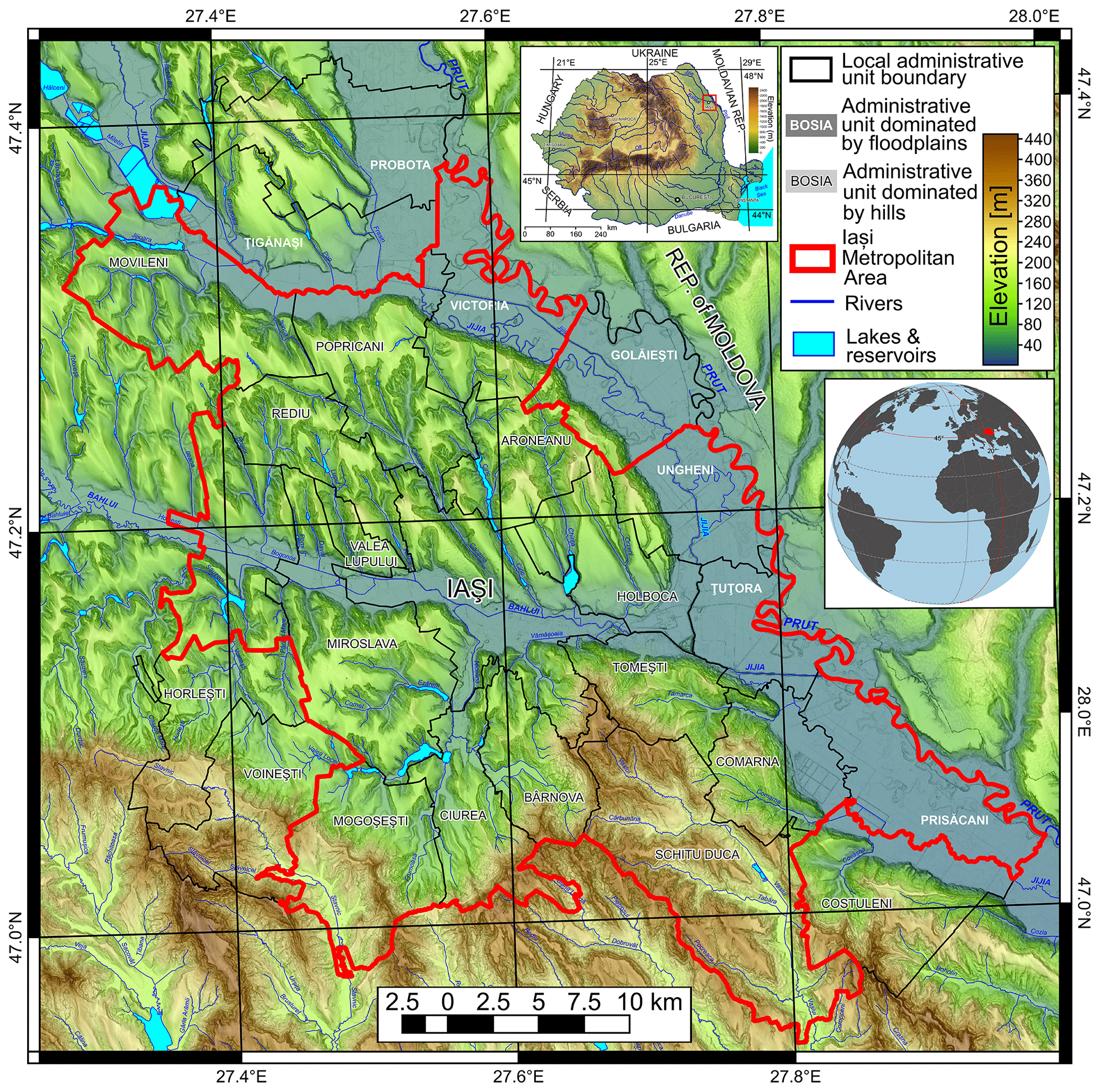
Figure 1The geographical position of the study area.
A new peri-urban area is developing spontaneously around the city of Iași, which is growing rapidly but chaotically, generating severe problems related to environmental quality and the future possibilities of landscape planning (Stoleriu, 2008). These complex changes in the recent past have created a greater degree of vulnerability of the population to natural hazards. A synthesis (Rotaru and Răileanu, 2009) of the damages caused in the 2000–2005 period by rain, hail, strong winds, and landslides in Iași County (NUTS 3 level, which includes IMA; nomenclature des unités territoriales statistiques, nomenclature of territorial units for statistics) revealed losses estimated at RON 37 million (around EUR 11.5 million at the time). Also, earthquakes are a constant threat to the life of people and to dwellings: in terms of the total affected dwelling stock, Iași County was affected most by the 7.1 MW subcrustal earthquake in 1977 (Georgescu and Pomonis, 2008), and it remains one of the most vulnerable to seismic hazard in Romania (Bunea and Atanasiu, 2014; Dutu et al., 2018)
To differentiate the risk perceptions of interviewees based on geographic location in the major landforms of the study area, the communes in which the present study was carried out have been split into two categories: (i) floodplain communes, located mainly on the major floodplains in the area (the Prut, Jijia, and Bahlui floodplains), and (ii) hilly communes, with a large development of hillslopes and associated geomorphological processes: landslides and soil erosion (Fig. 1).
2.2 Natural hazard characterization and future climatic trends
Natural hazards considered in our study are droughts, rainstorms, heavy snowfall, floods, landslides, soil erosion, and earthquakes.
Droughts in north-eastern Romania are associated with anticyclone conditions in summer and autumn, characterized by high temperature and low precipitation. The most frequent periods with drought appear in August, while the lengthiest appear in October, and the shortest are in June (Mihăilă, 2006; Pelin, 2015). The impact of droughts on rural communities is high in north-eastern Romania, and it can affect a wide range of activities (agriculture, forestry, livestock, water supply, and industry). The quality of public health is also affected by drought and is considered one of the main factors of rural poverty (Chiriac et al., 2005). Considering the intensity and multi-annual variability of droughts on the Moldavian Plateau, Cismaru et al. (2000) found that for the 1981–1998 period the percentage losses of crops have a logarithmic relationship with drought intensity at the end of the vegetation period (usually October). In some parts of the Moldavian Plateau these losses reached up to 41 %–50 % in the mentioned period for corn crops and 40 %–43 % for sugar beet or alfalfa. The historical trends (over the last 50 years) of droughts in north-eastern Romania are of increasing frequency but decreasing magnitude (Minea and Croitoru, 2015, 2017; Minea et al., 2016; Spinoni et al., 2015), while the forecast has a slight increase (Stagge et al., 2015).
The majority of annual precipitation comes from rainstorms, which are highest during the summer and frequent in late spring and at the beginning of autumn (Mihăilă, 2006). In Iași, the frequency of rainstorms is up to 40 per year, the maximum 24 h precipitation was 136.7 mm in June 1985, when in 3 d Iași received 193.8 mm of rainfall, and the monthly cumulated value almost reached 300 mm (Mihăilă, 2006; Niculiță, 2020). In the proximity of Iași, toward the contact with the Central Moldavian Plateau, the 24 h maximum value was even higher: at Sinești (30 km east-south-east) 185.3 mm fell in 12 h; at Mogoșești (15 km south-east) 154.4 mm fell; and at Bârnova (10 km south) 167.9 mm fell (Minea, 2013). Hail is a common phenomenon, associated not only with rainstorms, with an aleatory distribution in space and time, but also with important events in 1950 and 1984, which produced important damage to agriculture (Mihăilă, 2006).
The mean yearly number of snowfall days is 45 in Iași, but the annual variation is between 16 and 70 (Mihăilă, 2006). Heavy snowfall can negatively affect agriculture and society when they happen very late, in April or even May, or when the intensity is extreme during winter (Mihăilă, 2006). Blizzards usually manifest from December to February (in February being the most frequent), but early (November) or late (April) events can appear (Mihăilă, 2006; Niacșu et al., 2019). In Iași, there is a mean of 9 d/yr, but the variation is between 0 and 22 d/yr. During blizzards the wind has a mean speed of 50–75 km/h, with a predominant direction from the north-west and north, the maximum speed registered being 200 km/h in 1966 (Mihăilă, 2006).
Floods are widespread on the Prut River, where the two remarkable ones occurred in 2008 and 2010 when thousands of hectares were covered by water and many settlements were threatened and partially evacuated (Romanescu et al., 2011a, b; Romanescu, 2015). Much earlier, a 1991 event produced significant damages in the Jijia River's floodplain (Romanescu et al., 2017). In the Bahlui catchment, the hydro-technical infrastructure has diminished the frequency and severity of floods (Minea, 2013), which had critical negative impacts on the population of the city of Iași before 1960 (Tufescu, 1935). The effect of major floods in the last century on settlements in north-eastern Romania was recently depicted using detailed topographic maps: dozens of villages were partially or entirely displaced in the Moldavian Plateau (Văculișteanu et al., 2019) in the last 100 years. In north-eastern Romania, climate change is expected to increase precipitation extremes in both wet and dry regions as has happened in the past (Donat et al., 2016, 2017; Ingram, 2016; Jacob et al., 2014; Kurnik et al., 2017). It is predicted that the flood magnitude will increase (Alfieri et al., 2015; Reker et al., 2017), so probably the number of flood-related deaths in Romania will continue to be one of the biggest in Europe (Vanneuville et al., 2017).
Landslides and soil erosion are common natural hazards in the study area. In the recent decades, landslides have been slow-movement reactivations that generated household displacement and infrastructure destruction (Niculiță et al., 2017, 2018). One of the most destructive recent events near our study area was reactivation of the Pârcovaci landslide in December 1996, triggered by heavy rains and snowmelt: 97 houses were destroyed or heavily damaged, affecting up to 400 inhabitants (Cioacă and Dinu, 2002; Rotaru and Răileanu, 2009). In a recent study, Niculiță et al. (2018) have identified and mapped a total number of 518 landslides that happened in the last century in the Iași metropolitan area. They are usually reactivations of old landslides and present an obvious temporal pattern in a strong relationship with precipitation variability. Their low magnitude and the fact that almost all the identified landslides happened outside populated areas show that landslides could be perceived as not so dangerous by the inhabitants. But the situation could change in the future, considering the continuing expansion of the built-up area (Cîmpianu and Corodescu, 2013; Iațu and Eva, 2016) and future changes in climate (Niculiță, 2020). Soil erosion is favoured by fragmented topography, the increased tendency for extreme meteorological events, and the land use. These characteristics make our study area one of the most critical hotspots of soil erosion in Romania (Prăvălie et al., 2020).
The city of Iași is located about 200 km from the Vrancea region, one of Europe's seismic hotspots. Since 1800, seven earthquakes with moment magnitudes (MW) above 7 were registered there, while four major events marked the last 120 years, measuring 7.1 MW (1908 and 1986), 7.4 MW (1977), and 7.7 MW (1940) (Lungu et al., 2007; Mărmureanu et al., 2011). The last strong earthquake (4 March 1977, 7.4 MW, with 109 km depth of the hypocentre) was the cause of much socio-economic damage in Romania (exceeding USD 2 billion at that time), claiming the lives of 1578 people and injuring another 11 300 persons. At a national scale, the impact was huge: 32 897 collapsed or demolished dwellings, 34 582 homeless families, 763 industrial units affected, and many other damages in all sectors of the economy (Georgescu and Pomonis, 2008). Although located relatively far from the epicentral zone, Iași County was the most affected in Romania in terms of percentage of dwelling stock affected: 47 % were affected, including 11 % destroyed, 13 % requiring strengthening, and 23 % requiring repair (Georgescu and Pomonis, 2008). Since then, minor damages were reported from earthquakes of over 6 MW in 1986, 1990, and 2004.
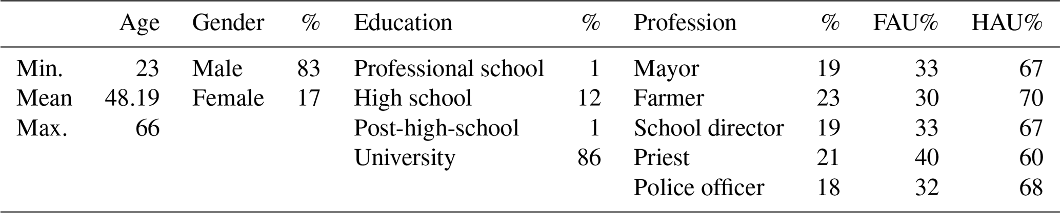
The selected local stakeholders represent different characteristics in terms of power, legitimacy, and urgency, following the stakeholders' salience theory of Mitchell et al. (1997). This model includes stakeholder powers of negotiation, their relational legitimacy with the organization, and the urgency in attending to stakeholder requirements (Mainardes et al., 2012). According to Mitchell's classification, we selected dominant stakeholders (mayors and police officers), discretionary stakeholders (farmers), and dormant stakeholders (school directors and priests). Semi-structured in-depth interviews were run from March 2017 until October 2018 involving 118 stakeholders: 23 mayors, 27 farmers, 25 priests, 21 police chiefs, and 22 school directors (Table 1). In Romania, as in many other countries, public institutions are organized at the administrative level, every commune/town having a municipal building, schools, churches, and police headquarters. The leaders of these institutions (mayors, police chiefs, and school directors, and in few cases, their deputies) were recruited directly to participate in the present study. Priests and local entrepreneurs (farmers) were randomly selected and interviewed on-site.
The questionnaire (Table A1 in Appendix A) was organized into two parts: the first with pre-defined questions (with a 5-point Likert scale) regarding the assessment of risk perception induced by natural hazards: level of threat, probability of occurrence, future frequency (dichotomic), personal experience (dichotomic), level of knowledge (dichotomic), level of preparedness, risk management, communication, and trust. In the second part discussions focussed on environmental and hazardous phenomena that threaten the places where respondents live and work. Interviews took from 30 to 50 min according to the participant's desire to respond to the open questions with their personal experience. In most cases, there were constructive approaches, especially in the second part of the interview, where some majors considered it beneficial for other employees of the major's office to participate in further discussion once the interview was concluded.
There is a clear gender imbalance in the sample of stakeholders considered for the interviews (Table 1). This is due to the specificity of certain professions in Romania (priests and police officers are predominantly men) or the perpetuation of older mentalities regarding the occupation of positions at the top of public administration (the case of mayors being represented mostly by men). Only for school directors the situation was more balanced: 63 % were women. The majority of the stakeholders have a university degree, a mandatory requirement for the roles of priests and police officers. A large proportion of stakeholders (88 %) live in the area where they work (same community or neighbouring communities), which might lead to their perception amplifying high-probability risks and reducing low-probability ones (Bernardo, 2013). The age distribution is skewed toward older persons, especially in the case of mayors (mean age 53.6 years) and school directors (49.2 years) in contrast with a younger generation of police officers (39.4 years).
Table 1Descriptive statistics of interviewees. FAUs represent administrative units dominated by floodplain areas, and HAUs represent administrative units dominated by hilly areas.
3.1 Statistical analysis
The statistical analyses was performed in R stat (R Core Team, 2020).
There is an ongoing debate if Likert data is fit to be transformed to an interval scale by considering that the distance between ordinal-scale elements is the same (Cliff, 1996). Some argue that Likert scale data typically do not meet the assumptions of the parametric tests (Baker et al., 1966; Stevens, 1968; Gaito, 1980; Knapp, 1990; Jamieson, 2004; Gardner and Martin, 2007; Mangiafico, 2016; Kero and Lee, 2016). Others argue (Armstrong, 1981; Kanpp, 1990; Pell, 2005; Norman, 2010) and prove with study cases (Carifio and Perla, 2007, 2008; de Winter and Dodou, 2010; Mircioiu and Atkinson, 2017) that while conceptually parametric statistics is not appropriate, in practice the differences are not important, and in this regard using parametric statistics brings their robustness and sensitivity into the analysis.
While this issue as to what methods, parametric or non-parametric, are better for Likert scale data is still disputed, we have chosen to comply with the standard statistical assumptions, especially regarding the failure of parametric statistics in the case of extreme values of ordinal data and unequal interval scales (Baker et al., 1966; Armstrong, 1981).
The statistical analysis was performed in three main steps (Openheim, 2000): (i) univariate analysis, (ii) bivariate analysis, and (iii) multivariate analysis.
The univariate analysis was performed by plotting the relative frequencies on the Likert scales to provide descriptive statistics for a first overview of the data. This approach is straightforward in identifying the overall perception of stakeholders toward a particular risk or factor and in ranking it by the majority of data (the likert R stat package plots the Top 2 Box score percentages, which is another measure used for Likert scale data).
Further, the bivariate analysis consisted of applying various measures of association and independence between the variables to the cross-tabulations. First of all, we tested the association of perceptions with risks/factors and stakeholder characteristics (stakeholder type, village, commune, flood vs. hilly, gender, and education) in two-way tables.
We used the asymptotic generalized Pearson chi-squared test (chisq_test() function) from the R stat coin package (Agresti, 2002; Hothorn, 2008) to test the association of the observations of two variables in a contingency table, one ordinal and the other categorical (two-way cross-tabulation with the ordinal variable in the column). The null hypothesis is that the variables are not associated with each other, so they are independent. If the null hypothesis is rejected, then the variables have a certain degree of association: they are not independent. Vice versa, the presence of dependence means that the perception of the stakeholders about a certain risk/factor is different from the other risk/factors or that the perception of the stakeholder is influenced by its appurtenance to certain groups/typologies. This test can be applied to categorical and ordinal data, but the ordering is not considered, and the strength of association is not available.
The Kruskal–Wallis rank sum test is more powerful because it uses the mean of the rank to assess if there are differences in the responses of different groups (Agresti, 2002; Mangiafico, 2016), not requiring further assumptions about the distribution of the data. However, the test is fit for small samples in which there are not normal distributions. The null hypothesis states that the groups represent populations stochastically equal (if the shape of the distribution is not considered to be known and is of a similar shape and spread), while the alternative hypothesis is that at least one sample stochastically dominates another sample. Post hoc analysis can pinpoint which groups are different from other groups (Mangiafico, 2016). In the case of our research questions, this test is able to show if the perception of stakeholders is different by risk/factor (RQ1) or if the perception toward a certain risk/factor is significantly different as a function of stakeholder characteristics. The test was performed using the kruskal.test() function from R stat (R Core Team, 2020).
When the difference exists (the null hypothesis is rejected), Freeman's epsilon-squared statistic was used to assess the strength of the difference of one ordinal variable over one nominal variable (Mangiafico, 2016). This statistic ranges from 0 to 1, with 0 indicating no association and 1 indicating perfect association. Values bigger than 0.26 were regarded in our case as a measure of powerful association in the presence of dependence (considering the values proposed by Mangiafico, 2016). This measure was computed using the epsilonSquared() function from the rcompanion R stat package (Mangiafico, 2021). A post hoc analysis was performed in the cases where the Kruskal–Wallis test shows significant differences in the groups to show which groups are different from each other group. The post hoc analysis uses pairwise Mann–Whitney U tests, based on the p value, that allow for the identification of significantly different items (Mangiafico, 2016).
Finally, we applied a multivariate method for those questions and risks that were found conclusive in the bivariate analysis step. CA (correspondence analysis) is a graphical method for exploring the relationships between variables in contingency tables (Greenacre, 2007) by assessing the interaction (Jobson, 1992). The theory behind the method is straightforward, based on the singular-value decomposition of the matrix data structure of the contingency table. We have chosen this method because it describes our data graphically to show the differences between stakeholder types or other categorical variables, especially for those with big Freeman's epsilon-squared values. The Likert scale with the answer to the question is considered the dependent variable, and the variants of the response or the categories of stakeholders or other associated categorical data (flooded or non-flooded communes) are the independent data.
We used mainly ordinal vs. categorical cross-tabulation tables and CA contribution biplots (with the ca R stat package; Nenadic and Greenacre, 2007; Greenacre, 2013), which display the data in a two-dimensional space using the first two extracted principal coordinates (and which should contribute to the majority of the variance) from both rows and columns, in order to get an idea of the association between rows and columns variables of the two dimensions. The plot is asymmetric, with the values of the axes corresponding to the standardized residuals and the points that are contributing very little to the components being located close to the centre of the biplot. The column variables (e.g. stakeholder type) are displayed as oriented vectors, while the Likert scale counts are displayed as dots with size proportional to the count. The orientation of the stakeholder type vector toward one of the axes shows its contribution to the variance of that axis. If the angle between the vector and the lines is 45∘, then the contributions to the two axes are the same, while if the angle is smaller toward a certain axis, the greater the contribution to the variance of that axis is. The length of the arrow vectors is proportional to their contribution to the two-dimensional solution. Since we have an ordered variable and the distances between the categories are not the same, there is no logic in taking into account the distances along the axes of the CA plot and making comparisons (although this type of plot allows that, in the sense that the axes are scaled to a common scale). The points that are close to the centre of the biplot contribute very little to the solution, while those which are too far might be considered outliers.
Usually, the differences between the responses of different stakeholder types are either striking and showing the overall importance of every stakeholder type or non-significant, so we have chosen the CA plots because they easily show the associations graphically. The circles' colour intensity and diameter depend on the relative frequency, while only the arrows' colour intensity is proportional to relative frequency. In this way, low-frequency categories located on the periphery that give a false impression of importance can be identified because they are pulled toward the centre of the biplot (Greenacre, 2013). These can also be seen on other types of plots (Likert plots, bubble plots, mosaic plots, etc.) but often require more attention to be spotted.
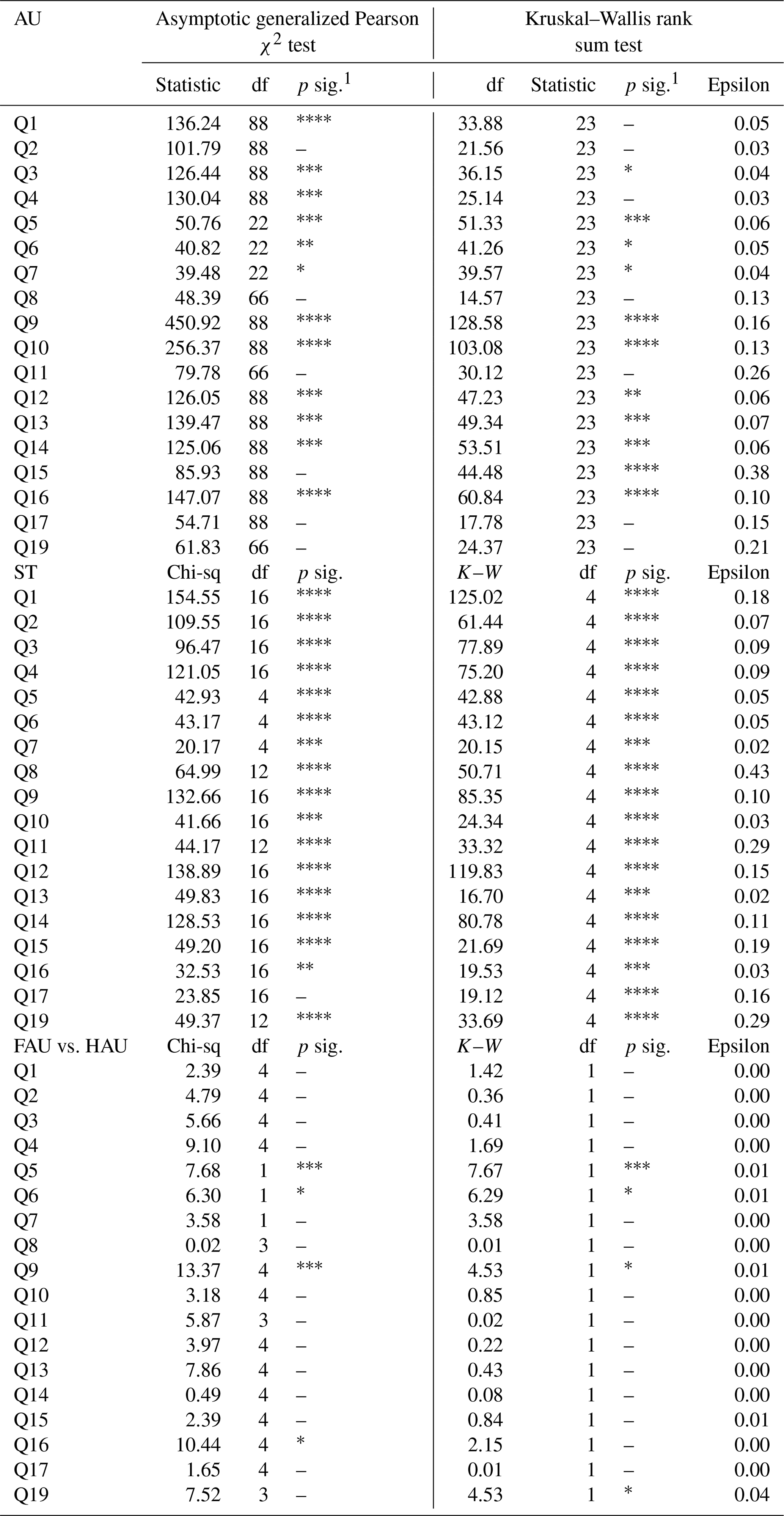
The extended statistical analysis results are not detailed here, except for relevant questions, for which the tables or the plots are presented. Appendix A1 should be consulted for full definitions of each question. In Table 2, the asymptotic generalized Pearson chi-squared and Kruskal–Wallis rank sum tests results are shown for the question items. In Table A2 in Appendix A, the same are shown for stakeholder types, administrative units, and floodplain vs. hilly areas. It can be seen that for all the question items (Table 2), the null hypothesis is rejected, and there is association present, with at least one sample being dominant; thus the response to RQ1 is affirmative. For some questions in the case of stakeholder types and administrative units, the null hypothesis is rejected, while for flood vs. hilly the null hypothesis is rejected for the majority of questions (Table A2 in Appendix A). The strength of dominance is indicated by Freeman's epsilon-squared statistics (Table 2), which show moderate strength for the first questions (Q1–Q4) and low strength for the rest. Thus, the response to RQ2 is affirmative for the majority of the questions, while for RQ3, the response is affirmative for some relevant questions only. Question-by-question results and interpretations based on the non-parametric tests are introduced below.
Table 2The non-parametric-test results for the question items with Likert scale responses. For the asymptotic generalized Pearson chi-squared test (left columns), the value of statistic, the degrees of freedom of the approximate chi-squared distribution of the test statistic, and the level of significance for the p value for the test are shown. For the Kruskal–Wallis rank sum test (right columns), the same three are shown, plus the epsilon-squared measure of association for the Kruskal–Wallis test.

1 p sig. is the level of significance for the p value: < = 0.001, < = 0.0001. df: degrees of freedom.
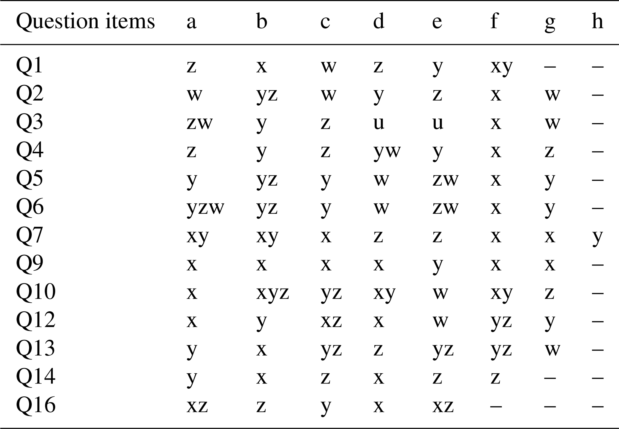
The post hoc analysis results using pairwise Mann–Whitney U tests are represented in Table 3 only for the question items, with the items sharing a coded letter (u–z) being not significantly different from each other. This table shows synthetically the situation that can be extracted from the Likert plots: it provides an affirmative response to RQ1.
Table 3Post hoc analysis results of pairwise Mann–Whitney U tests for the question items with Likert scale responses: a–h correspond to the question items shown in Table A1; u–z values sharing a letter are not significantly different.
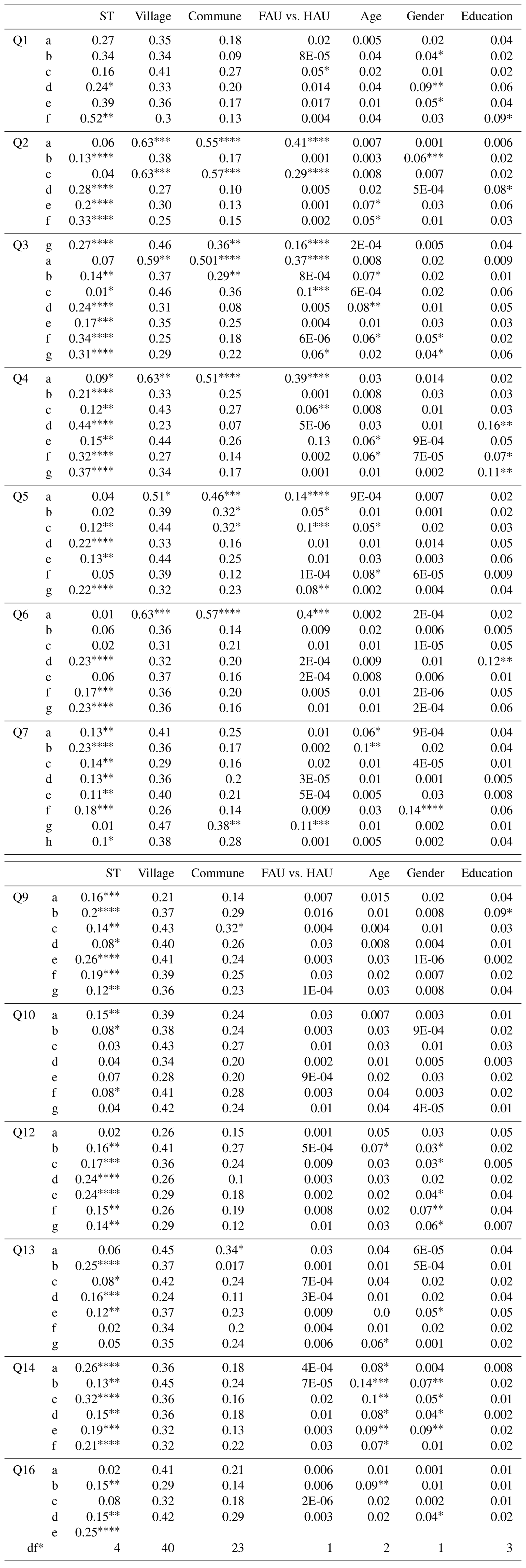
In Table A3 in Appendix A, the same test results as above are shown for various categories of every question item. Besides the stakeholder type, administrative unit, and floodplain vs. hilly area, the age category (young – 18–35 years, mature – 36–55 years, and old – > 55 years), gender, and education were considered. The results are a synthetic version of the Likert bar plots where the associations can be seen graphically and confirmed by the Top 2 Box score of the proportions.
4.1 The level of threat
The first question addressed to the interviewees was designed to investigate which main socio-economic and environmental factors could affect the communities' quality of life (Fig. 2). The majority of stakeholders (61 %) consider that the level of development is the main factor that can threaten the quality of life in their territory (Fig. 2). It is closely followed by risks induced by natural hazards (57 % of responses), then climate change (40 %), criminality (37 %), and environmental pollution (27 %), with technological risks (8 %) of much less concern.
The level of development and natural risks are similarly perceived as important threats, while criminality, environmental pollution, and climate changes are likewise lower as is shown by the post hoc analysis of pairwise Mann–Whitney U tests (Table 3).
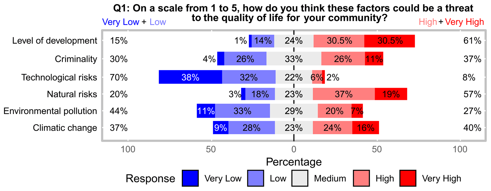
Figure 2The Likert plot of the stakeholders' responses regarding the perception of the factors that can threaten the local community.
Generally, the stakeholders who participated in the present survey consider droughts as the most threatening natural hazard for their communities and personally (Figs. 3 and 4).
Water scarcity is a direct consequence of the continental climate of the region: it has affected the agricultural economy of north-eastern Romania for centuries (Mărgărint et al., 2021; Niculiță, 2020). Many stakeholders reported a drastic reduction in the number of cattle, which, in the driest years, can reach 80 % of the total animals:
In the past 10 years, I had serious problems every year. I purchased a special car tanker to get water for livestock. And very little remains for vegetable crops. I get water from the reservoir (5 km away), and I do not know what will happen when it disappears. (a farmer, 35 years old, managing 300 ha of agricultural land and 35 cows)
They also consider that this hazard will affect their communities for many years from now. Alongside the dramatic reduction in agricultural production, the most dangerous problems occur regarding livestock.
Earthquakes represent the second most threatening hazard. The memory of the 1977 Vrancea earthquake, when Iași County registered the highest number of buildings affected in Romania (Georgescu and Pomonis, 2008), is still vivid in many stakeholders' memory. Although the norms in construction were strongly upgraded after this event, the discipline in building decreased suddenly due to the lack of legislation after 1989. How many dwellings have been built in recent years is not far from the interviewees' knowledge, and, from this point of view, many raised serious questions regarding the resistance of the new construction:
Many who bought new homes think they are new and strong, but at the next big earthquake, they will find that they were built just to be sold. (a mayor, 58 years old, personally affected by the 1977 earthquake)
The population's level of dissatisfaction concerning public works, transportation, and the environment is constantly increasing. Considering that no significant event triggered these permanent stressors, the actual situation of risks associated with natural hazards can be much more profound, although unknown to many of the inhabitants and their leaders.
Regarding differences in perception of the threat to the community vs. that to themselves (Fig. 3), the stakeholders' perception is similar (Top 2 Box score percentages very close), except for snowstorms, rainstorms, and earthquakes (Top 2 Box score percentages different), where the community threat is perceived as higher than the personal threat.
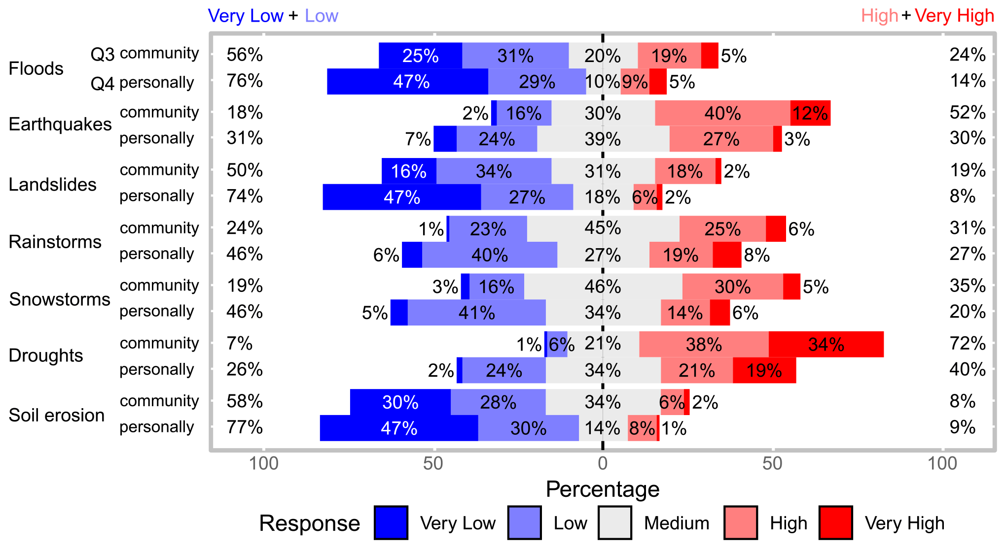
Figure 3The Likert plot of the stakeholders' responses regarding the perceived threat of natural hazards to the community (Q3) and their own person/household/income (Q4).
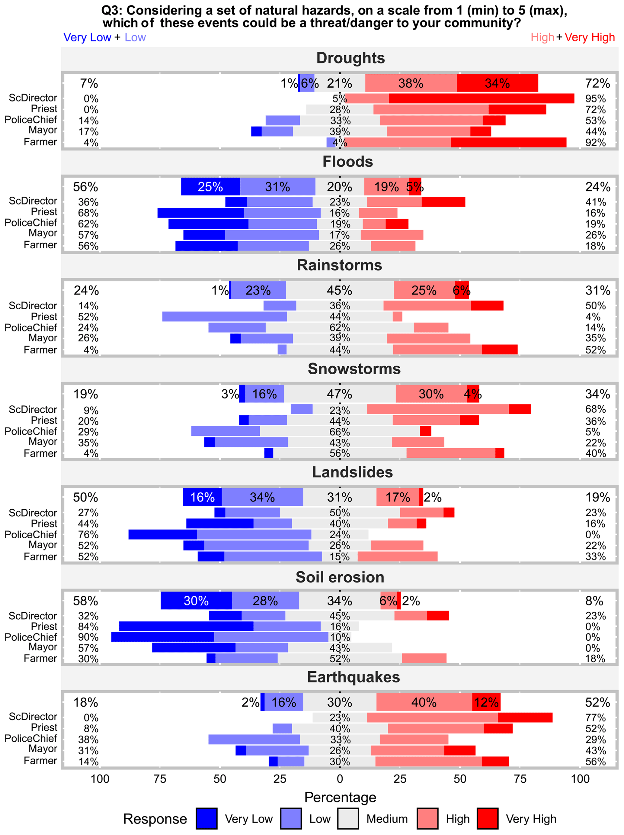
Figure 4The Likert plot of the stakeholders' responses regarding the perception of the natural hazards that can be a threat to the local community, split by natural hazard and stakeholder type.
A middle position is occupied by the hazards that registered a higher frequency: rainstorms and snowstorms had an increasing trend in the last decade in the study area. Consequently, their impact on communities is quite essential. During the year, the strongest storms occur in late spring and summer. In some cases accompanied by hail, the most significant damages are recorded in agriculture and in newly built areas with insufficient drainage infrastructure. When these phenomena occur in large areas, they can affect transport, trigger soil erosion, and generate high flows along fluvial channels, leading to the destruction of the bridges, the erosion, siltation of drainage and fluvial channels, etc. These issues were invoked as the most pressing by farmers, mayors, and police chiefs:
I have been here for few years. In the centre of the locality, there are no problems – there is asphalt on the street – but towards the valley, those who have moved to a house in the last 4 years live a nightmare every time it rains. The road is muddy and becomes impassable. (a police officer, 34 years old, in a settlement with many new dwellings)
Climate-related hazards that have a relatively low temporal frequency, like floods, landslides, and soil erosion, are perceived as imposing a low threat in general. The landslide risk is high in hilly regions of north-eastern Romania (Micu et al., 2017; Mărgărint and Niculiță, 2017; Bălteanu et al., 2020). In the last century, one of the most significant events took place 50 years ago in a succession of years with high precipitation (Pujină, 2008). With few exceptions, the memory of those events seems to have been erased. But the risk is still high, and people will again face landslide reactivations in years with an increased pattern of precipitation (Niculiță, 2020). There is a lack of prevention behaviour in terms of recent expansions of built areas due to several factors: investors' desire to build and sell and lack of knowledge and awareness of the danger by those who buy and by those who should make decisions regarding the expansion of built-up areas.
In our commune, the landslide risk has been solved: we have the study regarding landslide hazard and risk in an updated form, so we are in line with the legislation.” (the mayor of a commune affected by landslides in 1969–1972, 66 years old)
Outputs of the Kruskal–Wallis rank sum test and Freeman's epsilon-squared statistics show correlations between every category of natural risks and a set of socio-economic and geographic variables (for further results, see Tables A7, A8, and A9 of Appendix A). The most significant differences are in stakeholder type (answering RQ2), gender, age, spatial localization, and geomorphological context. The division between education types is far too uneven for any effect to be tested. The results indicate that the risk perception is dependent on stakeholder type, affirming RQ2. Also, it has been found that the age of the respondents is an essential factor regarding certain risks (Table 4) because some of them were born after certain important hazard events such as the 1977 earthquake, 43 years ago, or landslide events such as those between the 1970 and 1980 (Niculiță et al., 2017, 2018). For floods, climatic hazards, and soil erosion, it seems that younger respondents are more aware.
Table 4The mean age of the stakeholders by the response to the questions if the natural hazards have produced direct damage to the stakeholder.
The CA contribution biplot for Q1 from Fig. 5 shows the correspondence between the perceived role of natural hazards as threats to the local community by different stakeholder types, considering the first two dimensions that sum 96.8 % of the variance. The plot shows striking differences in the stakeholder type perception toward natural hazards (which overall are considered as threats to the quality of life – there is a significantly strong association of stakeholders' type perception as is shown in Table A3 in Appendix A for Q1 item d), by their different contributions to variance axis; if no difference would be present, the arrows would point to one main axis and would be very close to the centre. Police chiefs and priests perceive natural hazards as low and medium threats; mayors and farmers perceive them as high threats; and school directors perceive them as very high threats. The explanation of the low perception of hazards as threats to the community's quality of life in the case of priests and police chiefs is due to their relatively low knowledge of natural hazards provided by their professions. School directors, mayors, and farmers have a high level of awareness associated with the threats to the quality of life regarding the following factors: level of development (91 % of school directors), natural risks (82 % of school directors and 81 % of farmers), and climatic change (78 % of farmers and 55 % of school directors). The exception is related to technological risks, given the predominantly rural background of the communities. Priests and police chiefs generally expressed a low level of perception regarding the threats to local communities, with some exceptions, e.g. police chiefs regarding criminality, which is their duty. The same threat is seen by school directors, in association with their high level of childcare.
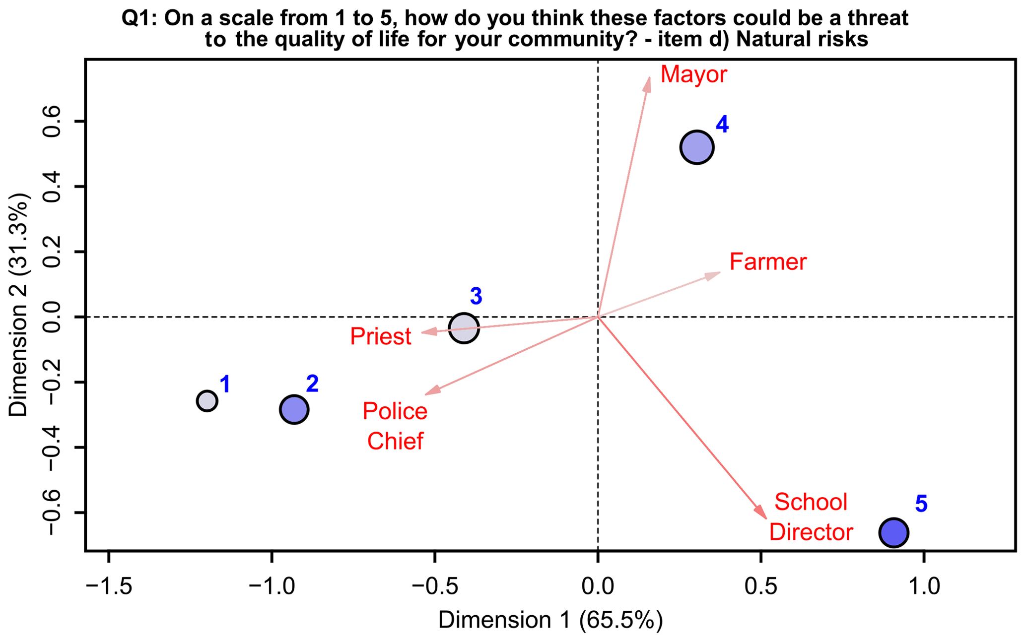
Figure 5The CA contribution biplot for the natural risks' role as threats to the community's quality of life as perceived by the stakeholders according to their type. The orientation of the stakeholder type vector toward one of the axes shows its contribution to the variance of that axis, while the arrow length is proportional with their contribution to the two-dimensional solution. The circles' colour intensity and size (diameter) depend on the relative frequency of the responses on the Likert scale.
The highest values of the perceived threat associated with droughts (Fig. 4) have been registered for school directors (95 %) and farmers (93 %) who expressed great concern compared to the other stakeholders. Also, earthquakes are seen as a significant threat by school directors (77 %), farmers (56 %), and priests (52 %). By interpreting the enlarged discussions during the interview, this could be considered as a consequence of still lively memories of the 1977 Vrancea earthquake (Armaș, 2006), a social trauma affecting the Romanian people, but also other factors are present: (i) a high vulnerability characterizes the majority of institutional buildings (especially schools and churches) to earthquakes (Mosoarca and Gioncu, 2013; Albulescu et al., 2020), and (ii) there are frequent exercises aimed at improving earthquake preparedness (in schools these exercises usually take place annually). The problem of the vulnerability of old buildings in Romania represents a constant public and scientific debate (Armaș, 2012; Banica et al., 2017), and, in this sense, we also raise on this occasion an alarm signal regarding the need for essential investments in the modernization of public spaces in urban and rural areas in Romania.
From these general results, significant differences have been recorded among the two geomorphological types of the administrative units (Figs. 1 and 6): floodplain administrative units (FAUs) and hilly administrative units (HAUs).
The results highlight that stakeholders have different levels of perception related to different hazards, according to the main events that have been recorded in recent decades: in the floodplain administrative units (FAUs in Fig. 6), there is a significantly higher degree of awareness concerning flood risk and possible threats, while in the hilly administrative units (HAUs) the level of threat associated with landslides and soil erosion is higher than in the FAUs.
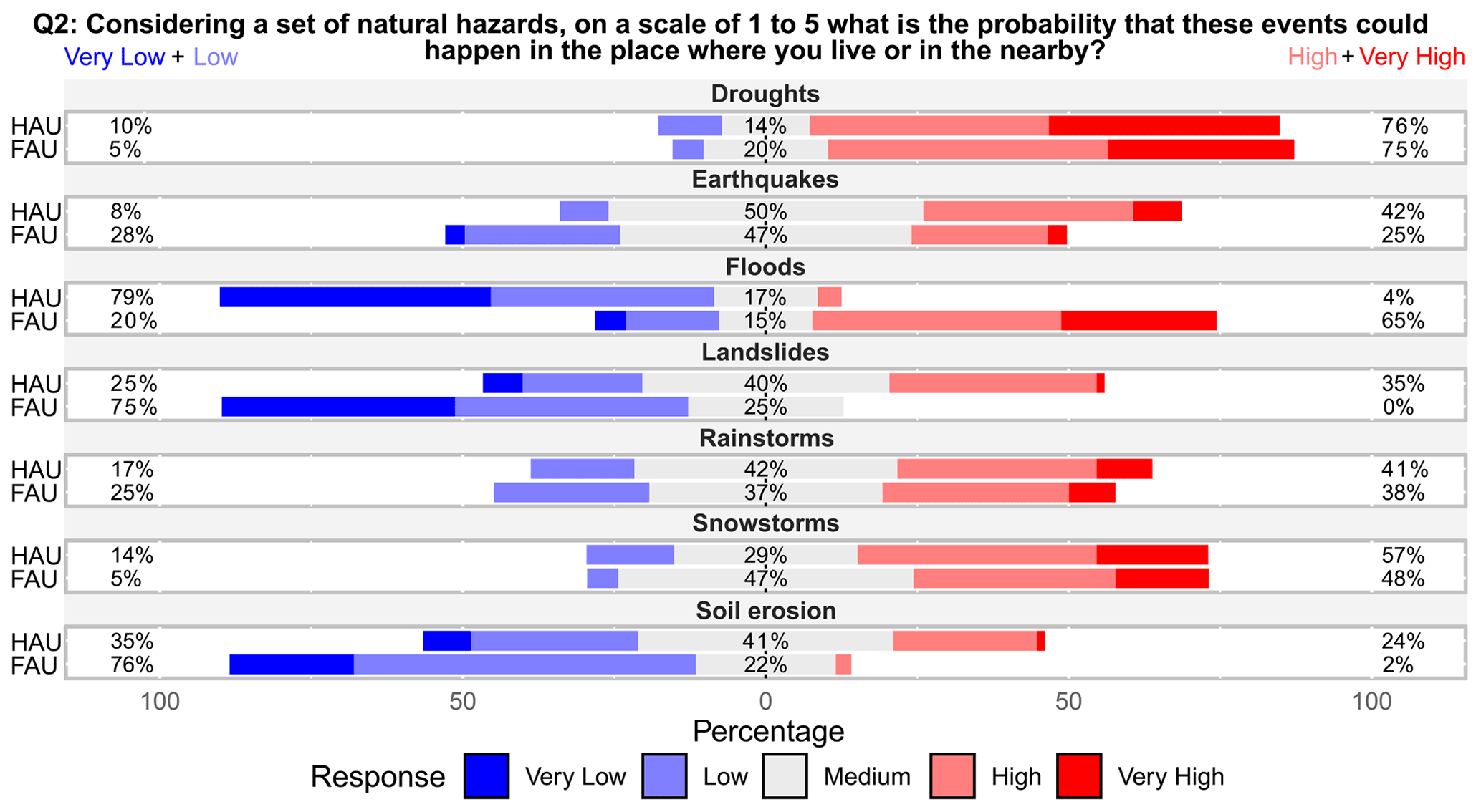
Figure 6The Likert plot of the stakeholders' perception of the probability of natural hazard occurrence concerning the dominant geomorphological landforms of the administrative units (AUs): floodplain (FAUs) and hilly areas (HAUs).
Again, droughts are the most life-changing natural hazards with the highest likelihood of occurrence. Rainstorms, snowstorms, and earthquakes follow them. A lower level of probability was assigned to soil erosion, landslides, and floods (Fig. 6). But here, there are essential differences, depending on the geomorphological type of the locality. The stakeholders who come from floodplain settlements have indicated a higher probability for floods than the others (HAU stakeholders) and a lower probability for landslides and soil erosion. This finding responds affirmatively to RQ3.
The main geomorphological characteristics which can influence different hazardous processes and the distance to the potential risk areas constitute essential factors of how different people perceive different risks (Bickerstaff and Walker, 2001; Heitz et al., 2009; Gao et al., 2020). Some natural hazards affect large areas (droughts, earthquakes, or snowstorms), while others (e.g. landslides and floods) are spatially concentrated in direct relation to topographic characteristics at the local scale. From this point of view, the settlements from the study area, as part of the Moldavian Plateau, have been constantly affected by landslides and floods (Văculișteanu et al., 2019), and their consequences are found in the answers given by the interviewees. Tables 2 and A3 of Appendix A and Fig. 6 show that the geomorphological context of the area where the stakeholder works is important in their perception regarding floods and landslide risk (although the investigation of the Likert plot is much more intuitive than the statistical tests), responding affirmatively to RQ3. These results are seen in the context of the social trauma of inhabitants managed by the stakeholders during the evacuations of some settlements along Prut Valley in 2008 and 2010. Due to the risk of flooding of inhabited areas, in July 2008, over 3000 inhabitants from Iași County, including the communes of Victoria, Ungheni, and Țuțora (Fig. 1), were evacuated (Ziarul de Iași, 2008).
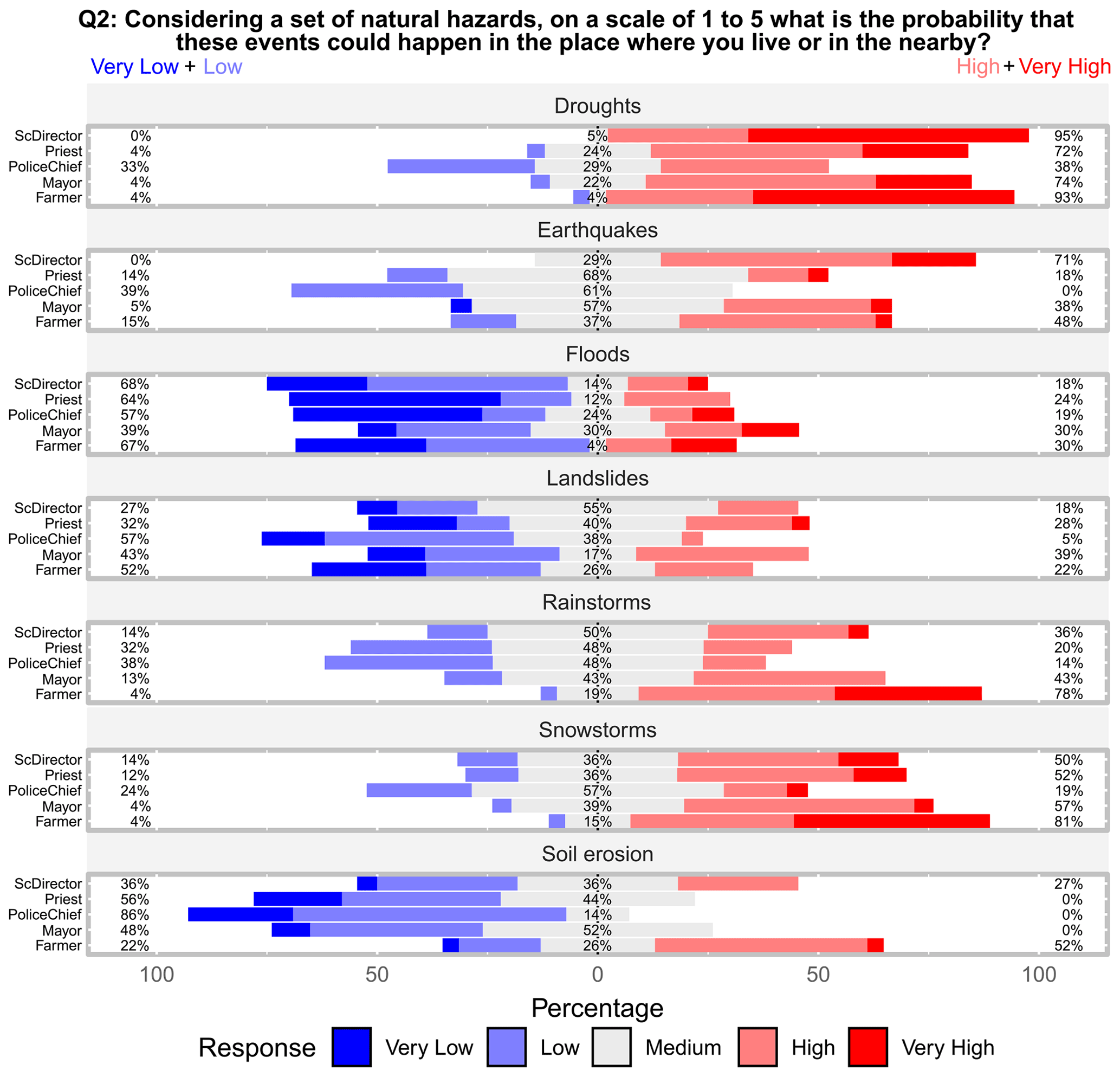
Figure 7The Likert plot of the stakeholders' responses regarding the perceived likelihood of different natural hazards.
Concerning the likelihood of occurrence of natural hazards (Fig. 7), some types of natural hazards are perceived to increase in the near future, especially climatic-induced hazards: droughts (86 %), rainstorms (68 %), and snowstorms (64 %). Landslides and soil erosion are perceived as not increasing, while for earthquakes, the results are balanced.
4.2 Personal experience and knowledge
Personal experience is one of the most critical factors influencing risk perception (Weber, 2006; van der Linden, 2014; Knuth et al., 2015; Öhman, 2017). The study participants indicated that they were affected mainly by droughts, rainstorms, and snowstorms, with farmers bearing high costs (Fig. 8). A large proportion of them was affected by droughts (93 %), rainstorms (78 %), snowstorms, and soil erosion (48 %). According to their activities and responsibilities, stakeholders are affected by natural hazards in their daily life, exposing them to different vulnerabilities. Also, knowledge about the community's past events makes them aware of the natural hazard threat at the community level but not at a personal level, especially for natural hazards that are not related to certain physiographic conditions (earthquakes, rainstorms, and snowstorms; see Fig. 9).

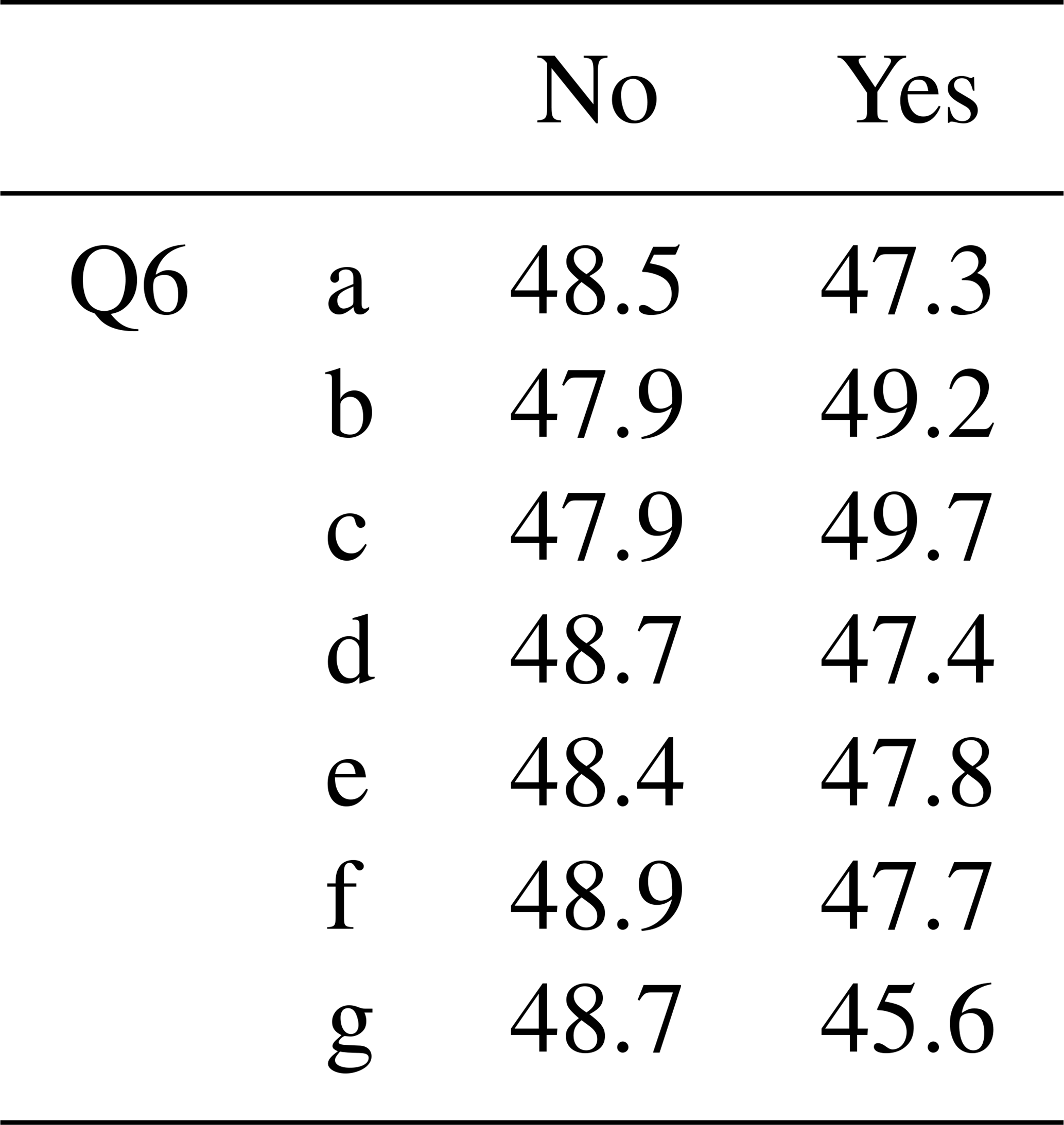
The other stakeholders were affected in a smaller measure by soil erosion. This process can generally pose problems only to those who directly connect with the land, which affects the built-up areas less. It is shown that experience is higher with age (Table 4), not only especially for the analysis with earthquake occurrence (the mean age is lower for those who reported no damage due to earthquakes; Table 4, Q6 item b) but also for landslides (Table 4, Q6 item c). These are disasters that, for their high magnitude, can be impressed vividly in people's memory. Stakeholders' role in disaster risk management and coordination allows them to remember the most significant events where they served the community. In contrast, memory of slow-onset events (e.g. droughts or soil erosion) can disappear quickly.
The knowledge of participants about natural hazards has been investigated through several sub-questions. Stakeholders get information differently about the probability of occurrence and the severity of these events. The majority get information from the TV/radio (82 %), friends/family and community peers (60 %), and social networks on the internet (53 %). The more official channels are the least represented with national information initiatives (47 %), school (44 %), local administration (41 %), and volunteer associations (40 %). Looking at the triggering factors of those events, stakeholders mentioned all sub-sections from the questionnaire (Table A1 from Appendix A) that they consider to have an important influence on the negative impact of natural hazards. Some exceptions have been registered for 57 % of mayors who responded that uncontrolled urbanization and unmanaged land use planning are not influencing the occurrence of any hazard. Local administration is controlling the land use planning, and, in any case, this might be the cause of negative consequences derived by climate extremes and geological movements.
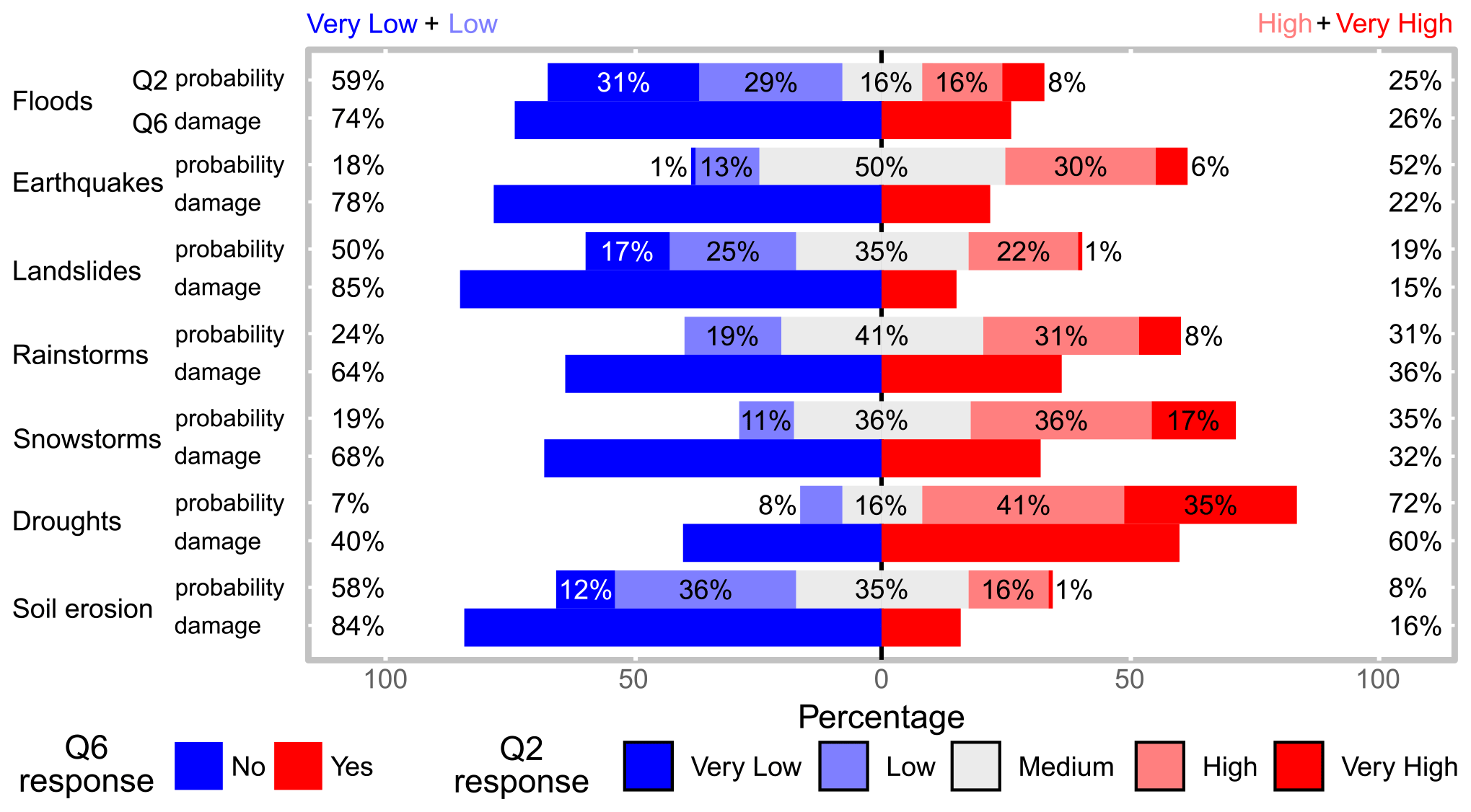
Figure 9Likert plot of the stakeholders' responses regarding the perception of the probability of natural hazard appearance in the local community (Q2) and the experience of them producing damage to their person/household/income (Q6).
The majority of priests and mayors do not consider that climate change can exacerbate the negative consequences of natural hazards (56 % and 22 % of them indicated “low” and “very low”, respectively). Among solutions to avoid the negative consequences of natural hazards, results showed a uniform answer among all stakeholders, except that the victims' compensation scheme was noted especially by mayors. Financial-compensation schemes represent a particularly sensitive issue in the post-communist society of Romania. Many interviewees highlighted that these compensations could encourage non-compliance with the law, especially regarding unauthorized construction on land at risk of floods and landslides.
4.3 The level of preparedness
The level of preparedness was investigated individually and regarding the community. Overall, the results indicate a low level of preparedness in the case of all the natural hazards discussed. The lowest ranks were given to soil erosion (64 % unprepared), droughts (58 %), earthquakes and landslides (55 %), floods (52 %), rainstorms (50 %), and snowstorms (35 %). It seems that, despite a low level of readiness, stakeholders feel a bit more prepared to withstand the consequences of storms and floods. Snowstorms affect the communities in winter (and exceptionally in spring, for example in April 2018), and agriculture does not suffer. Life in rural areas can be more comfortable compared with urban areas. In Romania, after recent intense snowstorms such as those from January 2008 (Georgescu et al., 2009) or January–February 2012 (Bălteanu et al., 2013), rural settlements were endowed with specialized equipment in rapid intervention, especially in the case of roads, and these endowments seem to improve the respondents' concerns.
Similarly, the existing embankments along rivers (Prut, Jijia, and Bahlui) have often been invoked during discussions as ensuring a relatively good level of protection, especially of built-up areas. The lower level of preparedness is associated with soil erosion and landslides, for which many stakeholders declared their lack of knowledge concerning the processes themselves and related protective measures. The survey results made us respond affirmatively to RQ2, which states that the level of preparedness depends on the risk type.
The same pattern of the answers was registered in the assessment of communities' preparedness level. However, preparedness was low, and stakeholders affirmed strongly that their preparedness and that of their community could be increased by good training and knowledge of natural hazard occurrence and mitigation practices. Asking how much they think that their personal knowledge might increase the level of preparedness of their community (Q11 from Table A1 from Appendix A) reveals significant differences among stakeholders. Whereas for school directors, “high” and “very high” responses reached 95 %, for police chiefs, the percentage dropped to 14 %. Intermediate values were recorded for other stakeholders: “high” and “very high” answers were given by 67 % of farmers, 56 % of priests, and 39 % of mayors. Police chiefs and mayors are responsible for risk management during an emergency, and preparedness is at the base of their training. But surprisingly they do not see their level of preparedness as increasing that of the community, probably because they are aware of their inability to fully control individual decisions (for example the old people who refuse to leave the property when the flooding is imminent). School directors who have the duty of caring for small children feel that individual preparedness is the key to successful disaster management, evacuation, and recovery. In this regard, participation in simulation evacuations is a crucial step for a positive response to potential disaster. Most of the stakeholders declared that they had participated, especially in the simulations concerning earthquakes, and few of them indicated other specific hazards (e.g. fires). Seventy-two stakeholders (61 %) declared that they participated in simulations in the recent years, most of them in earthquake simulations (especially school directors and mayors). Stakeholders from floodplain communes declared participation in flood simulations. In a particular case (Aroneanu settlement, located close to Iași International Airport), stakeholders participated in a technological disaster exercise (aircraft crash). The period elapsed since the last simulation varies from a few months to over 10 years, the most recent being declared mostly by school directors.
The same differentiated pattern of stakeholder responses was recorded in respect of the level of their communities' preparedness.
4.4 Risk management, trust, and communication
Several factors have been listed (Fig. 10) and discussed as representing long-term solutions to improve current risk management plans.
Most of the participants agreed with all the items proposed. On the other hand, priests seemed to be the most pessimistic, especially in terms of predictability, people's preparedness, intervention, and recovery capacity. Again, the role of trust depicts a negative situation in which stakeholders showed low trust of mitigation and management measures (Fig. 11). As mayors followed the same trend, it is plausible to think that they delegate the responsibility during emergencies to other institutions, imputing ineffective planning and organization.
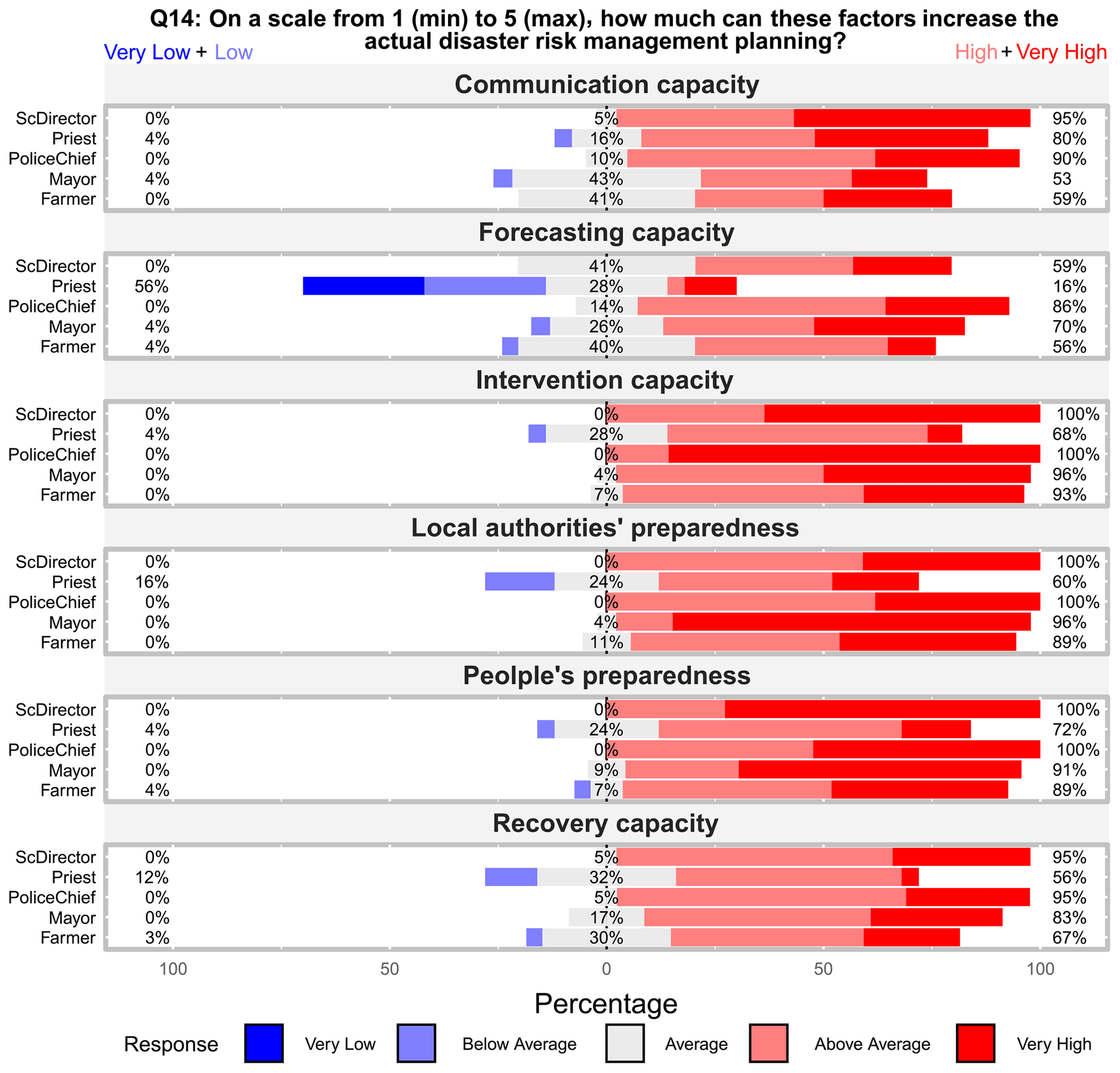
Figure 10The Likert plot of the stakeholders' responses regarding the factors which can increase the actual disaster risk management planning.
Question 16 (“In your judgement, how much are the opinions of the following actors taken into account when deciding about measures to adopt for preventing or reducing damage from natural hazard phenomena?”) presents a grouping of “high” and “very high” responses around 70 % for the following sub-sections: local communities, technicians/engineers, and elected representatives at local and national levels. A lower percentage (34 % of “high” and “very high” responses) has been registered for the sub-section “environmental organizations.” Among stakeholder types, we should highlight the higher percentages of “low” and “very low” responses in the following cases: priests for “elected representatives at the local level” (16 %) and “technicians/engineers” (16 %), school directors (50 %) and mayors (43 %) for “environmental organizations”, farmers for “local communities” (16 %), and “state elected representatives” (26 %).
The stakeholders' roles as leaders of their institution during events generated by natural hazards is critical. They refer to direct intervention in the affected areas and management and communication with the community's entire population. These issues were addressed in the following question (Q17 from Table A1 from Appendix A: “According to your position in society, how much do you think that your institution could help in the communication/management of people during the events associated with natural hazards?”). The gathered answers are not only generally in line with the level of social responsibility of the institutions that stakeholders represent according to legislation but also with the moral leadership in the community. “High” and “very high” responses were acquired as follows: from priests (88 %), police chiefs (86 %), mayors (74 %), school directors (64 %), and farmers (52 %). There are interesting absences of “low” and “very low” responses in the case of mayors, school directors, and priests, and there is a low proportion of these responses in the case of police chiefs (5 %) and farmers (7 %).
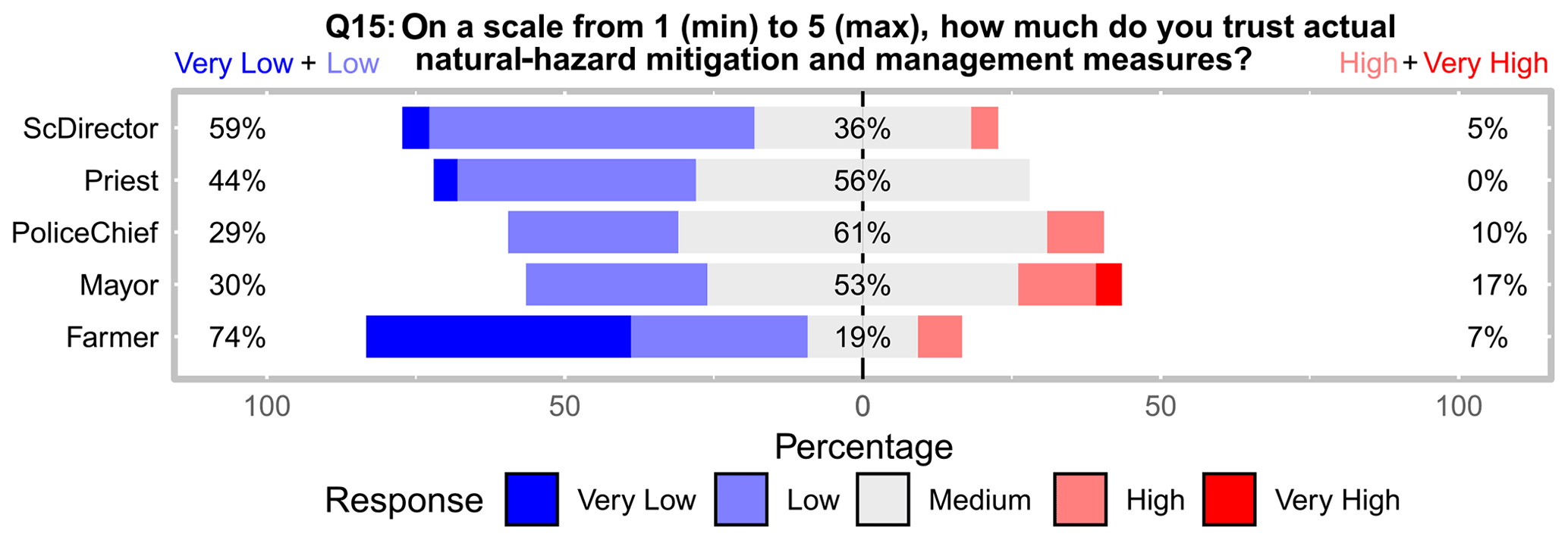
Figure 11The Likert plot of the stakeholders' responses regarding the trust in the actual measures for natural hazard mitigation and management.
The current study's importance lies in the intrinsic characteristics of the Iași area, being exposed and vulnerable to major natural hazards combined with the recent and historical contradictory socio-economic dynamics of Romania (Ignat et al., 2014). In line with a competitive European economy with an increasing educational and income level over the last 20 years, Romanian society followed positive trends with rapid urban sprawl. The fast development was characterized by a lack of planning and infrastructural investments leading to an increased vulnerability to natural hazards. At the same time, dissatisfaction and the feeling of insecurity of people were felt even at the political level that, since 1989, has led to a constant decrease in trust in national institutions and their leaders. In this fragile socio-economic and political environment, local stakeholders were involved in national programmes to help communities (primarily rural areas) to prevent, manage, and recover from emergencies, including weather extremes or natural hazards, because media, politicians, and other public actors very often attempted to discredit the potential negative impact of these phenomena. However, history shows that disaster communication was poorly managed, and local stakeholders lacked in coordinating people in all phases of risk management. The lacking knowledge and preparedness understanding of stakeholders pushed the need to investigate their actual perception of natural hazard threats to set the scene for improved management at the local level. Results revealed that farmers are more concerned, especially with climate-related hazards, which can directly affect their livelihood and income source. They might already receive incentives to protect the economic sector from the threat of natural hazards and/or invest in insurance products to safeguard household income (Saldaña-Zorrilla, 2008).
Mayors, school directors, and priests displayed a greater level of risk awareness of droughts and earthquakes, which are the major and long-lasting events for which planning, evacuation, and recovery are needed to manage the outcome of those events efficiently. Police officers were the only stakeholders recognizing the threat of floods because they were directly involved in recent flooding and rescue activities. Despite recognizing the probability of a broad set of natural hazards, the level of preparedness is perceived to be low. The poor vertical dialogue among stakeholders, the lay public, and higher authorities has disrupted communication and proactive behaviours of citizens, producing low levels of trust, and on some occasions, discarding hazard warnings. Stakeholders highlighted great interest in information and education programmes to reconstruct their network with the population and reduce adverse effects of natural hazards. The same results have been found in France, where a national concern is the need to find solutions and economic investments at the local scale for poor transparency and trust, leading to unmanaged and inefficient solutions and actions (Heitz et al., 2009). Mayors in Iași County need to be involved in the discussions and negotiations at the national level, exposing different interests of the community's representativeness. A stakeholders' network needs to be established at the local level, to share knowledge and know-how, enhance communication, and re-build a trust culture. Networked governance is also highlighted by Van Well et al. (2018) concerning the good example of the Nordic Centre of Excellence on Resilience and Societal Security network, which includes Denmark, Finland, Iceland, Norway, and Sweden and provides a synergy of communities, institutions, individuals, and infrastructure for societal resilience and community development. Similar approaches have been conducted in central Europe with representative examples for local communities (Gamper, 2008; Holub and Fuchs, 2009; Fleischhauer et al., 2012; Leitner et al., 2020). The perspective beyond the disaster response framework must “give affected communities a voice and recognize their risk perception as well as their active role in exploring strategies that ensure livelihood security on the long-term” (Heijmans, 2001). In that sense, Walker et al. (2014) characterized the “new governance” related to natural hazard threats and risk management strategies across several countries in Europe, emphasizing the “sometimes strikingly” political context in handling the threats of natural hazards. Simultaneously, the political agenda can help those networks implement monitoring systems for vulnerable buildings and facilitate the knowledge of local stakeholders, their safety, and their relationship with the population moving from a self-centred approach to a community-based approach. An objective level of preparedness of the communities seems to be achieved by the interviewed stakeholders. The need for a “culture of preparedness and prevention” (Ozmen, 2006; Adame, 2018) that is nowadays underestimated should be addressed as a long-term educational, behavioural, and knowledge-based approach. Another essential issue in disaster risk reduction and management is the involvement of scientists in local committees for emergencies, with specific roles (Gill et al., 2021), such as identification and characterization of potential multi-hazard areas; prioritizing effective, positive, long-term partnerships; sharing the experiences of others communities in best-practice risk management through improved access to hazard information; and embedding cultural understanding into the local natural hazard environment.
As a limitation of the current study, we highlight the limited analysis of socio-demographic factors influencing the interviewees' risk perception, which is due to how the participants were selected. Another limitation of this study concerns the multi-hazard risk perception assessment and the different nature, frequency, management measures, and costs of the natural hazards selected can make comparisons difficult. The need to incorporate multiple hazards is based on the need to avoid bias toward any single hazard. We approach local stakeholders with the most and least frequent ones, without cognitive or experiential biases.
The perspectives of this study should be continued in coming years to assess changes in the behaviour of stakeholders regarding awareness of the threats posed by natural hazards in a dynamic perspective. This should take into consideration future natural events and their adverse effects, as well as changes increasing (or not) the inter-community cooperation and compliance with legislation.
Despite local stakeholders' knowledge playing a key role during and after natural hazard occurrence in Romania, the occurrence and the severity of natural hazards are increasing, underlying decisional and managerial gaps among local stakeholders and authorities. For this reason, 118 local stakeholders were interviewed to determine their risk awareness and preparedness capacities over a set of natural hazards to understand where knowledge, action, and trust are most deficient. Results reveal that each type of stakeholder perceives natural hazards differently (RQ1). All sense a moderate level of threat toward the negative influence of natural hazards, with specific concerns towards climate-related hazards and earthquakes. In addition, stakeholders' level of perception and preparedness is also different considering the role and the responsibilities felt within the community (RQ2). Despite recognizing the probability of a broad set of natural hazards, the level of preparedness is perceived to be low. In addition, significant differences have been recorded among stakeholders in floodplain and hilly locations (RQ3). The topographical characteristics shape individuals' responsibility for the higher concerns of specific environmental threats (floods vs. landslides and soil erosion). This result reveals that local stakeholders have knowledge of the characteristics of their territory (understood as a natural and cultural environment) and the relative operative dynamics, but they are unable to operate with responsive actions. Stakeholders' lack of trust in the actual natural hazard management plans may work against what is expected from them; thus much engagement is needed to strengthen the link between national authorities in charge and local stakeholders, to prepare communities effectively for the future occurrence of natural threats.
The number of local stakeholders interviewed is relatively low compared to most studies that investigates risk perceptions of the lay public. This might be seen as a limitation, also for socio-demographic analyses. In addition, the selection of a multi-hazard risk perception assessment has limited the number of questions and their quality in terms of gathering in-depth details. We also recognize that, due to the different nature, frequency, management measures, and costs of the natural hazards selected, it is difficult to make comparisons and propose specific types of actions. The need to incorporate multiple hazards is to avoid bias toward a single hazard and to approach local stakeholders with the most and least frequent ones, without cognitive or experiential biases from the researchers. Having addressed and justified these limitations, there is a need to get further perspectives from a wider number of stakeholders in Romania and elsewhere, in order to enlarge the scale of knowledge regarding those local people who can really make a change and work as a bridge from institutional power. In addition, specific natural hazards need to be considered in order to be able to explore a wider set of interactive factors related to the cognitive and experiential knowledge of stakeholders as community guides for disaster risk reduction.
Table A1Questionnaire sample and variables' units of measurement.
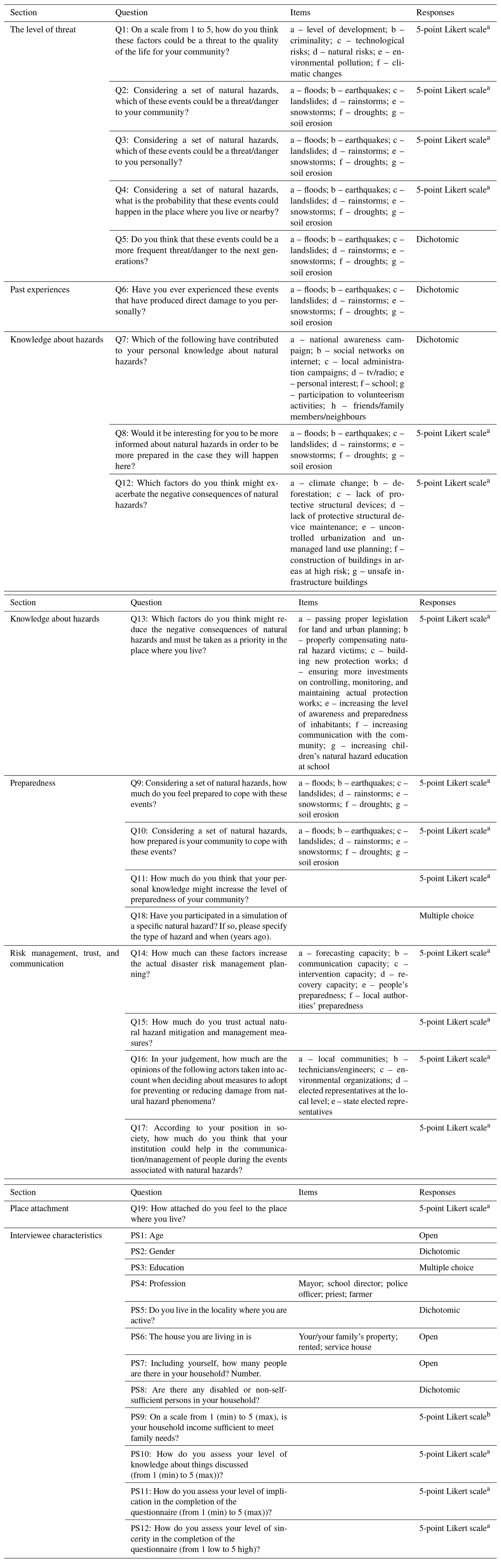
a The 5-point Likert scale is 1 – very low, 2 – low, 3 – medium, 4 – high, and 5 – very high. b The 5-point Likert scale is 1 – insufficient, 2 – below moderate, 3 – moderate, 4 – sufficient, and 5 – more than sufficient.
Table A2The non-parametric-test results for stakeholder types (STs), administrative unit (AUs), and floodplains vs. hilly areas (FAUs vs. HAUs).
1 p sig. is the level of significance for the p value: * < = 0.05, < = 0.01, < = 0.001, < = 0.0001. df: degrees of freedom.
Table A3The non-parametric-test results (the epsilon followed by the level of significance code) for question items by stakeholder types (STs), administrative unit (village and commune), floodplains vs. hilly areas (FAUs vs. HAUs), and demographic characteristics of stakeholders.
df: degrees of freedom. Level of significance: * < = 0.05, < = 0.01, < = 0.001, < = 0.0001.
The code is not publicly accessible because it is generic, but it can be provided through a request to the corresponding author.
Due to privacy issues the questionnaire data are not publicly accessible, but they can be provided through a request to the corresponding author.
MCM, MN, GR, and PT conceptualized the project and its methodology. MCM and MN performed the investigation. MCM, MN, and GR completed the formal analysis. MCM prepared the original draft of the paper. MCM, MN, GR, and PT reviewed and edited the paper. MCM administered the project. All authors have read and agreed to the published version of the paper.
The authors declare that they have no conflict of interest.
Publisher’s note: Copernicus Publications remains neutral with regard to jurisdictional claims in published maps and institutional affiliations.
MN was supported by a grant from the Ministry of Research and Innovation (CNCS–UEFISCDI, project no. PN-III-P1-1.1-PD-2016-0154, within PNCDI III). The funders had no role in study design, data collection and analysis, the decision to publish, or manuscript preparation. We thank three anonymous reviewers for helpful comments on earlier drafts of the paper. Sincere thanks go to Ian S. Evans for his diligent English proofreading of the article.
This research has been supported by the Unitatea Executiva pentru Finantarea Invatamantului Superior, a Cercetarii, Dezvoltarii si Inovarii (grant no. PN-III-P1-1.1-PD-2016-0154).
This paper was edited by Animesh Gain and reviewed by three anonymous referees.
Adame, B. J.: The persuasive efficacy of real versus salient hazard scenarios in motivating citizen-level hazard preparedness, International Journal of Disaster Risk Reduction, 31, 292–301, https://doi.org/10.1016/j.ijdrr.2018.05.019, 2018.
Agresti, A.: Categorical Data Analysis, Second Edition, Hoboken, John Wiley& Sons, New Jersey, 2002.
Albulescu, A.-C., Larion, D., and Grozavu, A.: Multi-Criteria Assessment of the Seismic Vulnerability of School Units in Vaslui City, Romania, in: Risk Analysis XII, WIT Transactions on Engineering Sciences, edited by: Syngellakis, S. and Fabbri, A., WIT Press, Southampton, UK, 17–28, https://doi.org/10.2495/RISK200021,2020.
Alcántara-Ayala, I. and Moreno, A. R.: Landslide risk perception and communication for disaster risk management in mountain areas of developing countries: a Mexican foretaste, J. Mt. Sci., 13, 2079–2093, https://doi.org/10.1007/s11629-015-3823-0, 2016.
Alfieri, L., Burek, P., Feyen, L., and Forzieri, G.: Global warming increases the frequency of river floods in Europe, Hydrol. Earth Syst. Sci., 19, 2247–2260, https://doi.org/10.5194/hess-19-2247-2015, 2015.
Alon, I.: COVID-19 and International Business: A Viewpoint, FIIB Business Review, 9, 1–3, https://doi.org/10.1177/2319714520923579, 2020.
Anders, I., Stagl, J., Auer, I., and Pavlik, D.: Climate change in Central and Eastern Europe, in: Managing Protected Areas in Central and Eastern Europe Under Climate Change, Advances in Global Change Research, edited by: Rannow, S. and Neubert, M., 58, Springer Science-Business Media Dordrecht, 4, 17–30, https://doi.org/10.1007/978-94-007-7960-0_2, 2014.
Armaș, I.: Earthquake Risk Perception in Bucharest, Romania, Risk Anal., 26, 1223–1234, https://doi.org/10.1111/j.1539-6924.2006.00810.x, 2006.
Armaș, I.: Multi-criteria vulnerability analysis to earthquake hazard of Bucharest, 608 Romania, Nat. Hazards, 63, 1129–1156, https://doi.org/10.1007/s11069-012-0209-2, 2012.
Armaș, I. and Avram, E.: Perception of flood risk in the Danube Delta, Romania, Nat. Hazards, 50, 269–287, https://doi.org/10.1007/s11069-008-9337-0, 2009.
Armaș, I., Ionescu, R., and Posner, C. N.: Flood risk perception along the Lower Danube river, Romania, Nat. Hazards, 79, 1913–1931, https://doi.org/10.1007/s11069-015-1939-8, 2015.
Armaș, I., Crețu, R. Z., and Ionescu, R.: Self-efficacy, stress, and locus of control: The psychology of earthquake risk perception in Bucharest, Romania, Int. J. Disast. Risk Re., 22, 71–76, https://doi.org/10.1016/j.ijdrr.2017.02.018, 2017.
Armstrong, G. D.: Parametric statistics and ordinal data: a pervasive misconception, Nurs. Res., 30, 60–62, https://doi.org/10.1097/00006199-198101000-00019, 1981.
Baker, B. O., Hardyck, C. D., and Petrinovich, L. F.: Weak measurements vs. strong statistics: an empirical critique of S.S. Steven's proscriptions on statistics, Educ. Psychol. Meas., 26, 291–309, https://doi.org/10.1177/001316446602600204, 1966.
Baker, V. R.: The Story of Vaiont: Told by the Geologist Who Discovered the Landslide, Earth Sci. Hist., 30, p. 295, 2011.
Bamberg, S., Masson, T., Brewitt, K., and Nemetschek, N.: Threat, coping and flood prevention – A meta-analysis, J. Environ. Psychol., 54, 116–126, 2017.
Banica, A., Rosu, L., Muntele, I., and Grozavu, A.: Towards urban resilience: A multi-criteria analysis of seismic vulnerability in Iasi City (Romania), Sustainability, 9, 270, https://doi.org/10.3390/su9020270, 2017.
Bălteanu, D., Micu, D., Baroiu, D., Dima, V., Dragotă, C., Mărculeţ, C., and Serban, P.: Snowstorm Spells of January-February 2012: Genesis, Manifestation and Effects in Buzău County Lowland, Apași Aerul: Componente ale Mediului, 2013.
Bălteanu, D., Micu, M., Jurchescu, M., Malet, J.-P., Sima, M., Kucsicsa, G., Dumitrică, C., Petrea, D., Mărgărint, M. C., Bilașco, S., Dobrescu, C.-F., Călărașu, E.-A., Olinic, E., Boți, I., and Senzaconi, F.: National-scale susceptibility map of Romania in a European methodological framework, Geomorphology, 371, 107432, https://doi.org/10.1016/j.geomorph.2020.107432, 2020.
Benedek, J. and Cristea, M.: Growth pole development and “metropolization” in post-socialist Romania, Studia UBB Geographia, 59, 125–138, 2014.
Bernardo, F.: Impact of place attachment on risk perception: Exploring the multidimensionality of risk and its magnitude, Studies in Psychology, 34, 323–329, https://doi.org/10.1174/021093913808349253, 2013.
Beshi, T. D. and Kaur, R.: Public Trust in Local Government: Explaining the Role of Good Governance Practices, Public Organization Review, 20, 337–350, https://doi.org/10.1007/s11115-019-00444-6, 2019.
Bickerstaff, K. and Walker, G.: Public understanding of air pollution: the “localisation” of environmental risk, Global Environ. Chang., 11, 135–145, https://doi.org/10.1016/S0959-3780(00)00063-7, 2001.
Bradford, R. A., O'Sullivan, J. J., van der Craats, I. M., Krywkow, J., Rotko, P., Aaltonen, J., Bonaiuto, M., De Dominicis, S., Waylen, K., and Schelfaut, K.: Risk perception – issues for flood management in Europe, Nat. Hazards Earth Syst. Sci., 12, 2299–2309, https://doi.org/10.5194/nhess-12-2299-2012, 2012.
Buchecker, M., Ogasa, D. M., and Maidl, E.: How well do the wider public accept integrated flood risk management? An empirical study in two Swiss Alpine valleys, Environ. Sci. Policy, 55, 309–317, 2016.
Bunea, G. and Atanasiu, G. M.: Overview of Romania's seismicity focusing on the North-Eastern region, Bul. Inst. Politeh. din Iași Sect. Constr. Arhit., 60, 43–52, 2014.
Burja, V.: Some aspects of employment in Romania's agriculture in the European context, Annales Universitatis Apulensis Series Oeconomica, 16, 41–51, 2014.
Burningham, K., Fielding, J., and Thrush, D.: “It'll never happen to me”: understanding public awareness of local flood risk, Disasters, 32, 216–238, https://doi.org/10.1111/j.1467-7717.2007.01036.x, 2008.
Carifio, J. and Perla, R. J.: Ten Common Misunderstandings, Misconceptions, Persistent Myths and Urban Legends, Journal of Social Sciences, 3, 106–116, 2007.
Carifio, J. and Perla, R. J.: Resolving the 50-year debate around using and misusing Likert scales, Med. Educ., 42, 1150–1152, https://doi.org/10.1111/j.1365-2923.2008.03172.x, 2008.
Ceobanu, C. and Grozavu, A.: Psychosocial effects of the floods perception and attitudes, Carpath, J. Earth Env., 4, 25–38, 2009.
Chiriac, D., Geicu, A., Humă, C., and Bleahu, A.: Efectele socioeconomice ale secetei asupra calităţii vieţii comunităților umane din România [Socioeconomic effects of droughts on life quality of human communities in Romania], Calitatea Vieții, 16, 313–331, 2005 (in Romanian).
Cioacă, A. and Dinu, M.: Landslide Reactivation in Moldavian Plateau 1996/1997. A case study: Pârcovaci, Annals of Valahia University of Târgoviște, Geographical Series, 2, 136–142, 2002.
Cismaru, C., Bartha, I., Gabor, V., and Scripcariu, D.: Studii asupra deficitului de producție determinat de secete in condițiile Moldovei [Studies on the production deficit caused by droughts in Moldova conditions], Ovidius University Annals of Constructions, 1, 53–57, 2000 (in Romanian).
Cîmpianu, C. and Corodescu, E.: Landscape dynamics analysis in Iași Metropolitan Area (Romania) using remote sensing data, Cinq Continents, 3, 18–32, https://nbn-resolving.org/urn:nbn:de:0168-ssoar-359736, 2013.
Cliff, N.: Ordinal methods for behavioral data analysis, Psychology Press, New York, 1996.
Comănescu, L. and Nedelea, A.: Public perception of the hazards affecting geomorphological heritage–case study: the central area of Bucegi Mts. (Southern Carpathians, Romania), Environ. Earth Sci., 73, 8487–8497, https://doi.org/10.1007/s12665-014-4007-x, 2015.
Comănescu, L. and Nedelea, A.: Floods and public perception on their effect. Case Study: Tecuci Plain (Romania), year 2013, Procedia Environ. Sci., 32, 190–199, https://doi.org/10.1016/j.proenv.2016.03.024, 2016.
Croitoru, A.-E. and Minea, I.: The impact of climate changes on rivers discharge in Eastern Romania, Theor. Appl. Climatol., 120, 563–573, https://doi.org/10.1007/s00704-014-1194-z, 2015.
Crețu, R. Z., Armaș, I., and Stănciugelu, I.: Psychological Vulnerability and Earthquake Risk Perception in Bucharest/Romania, EGU General Assembly, 2–7 May, Vienna, Austria, p. 8835, 2010.
De Winter, J. F. C. and Dodou, D.: Five-Point Likert Items: t test versus Mann-Whitney-Wilcoxon, Practical Assessment, Research, and Evaluation, 15, 1–16, 2010.
Dicu, I. and Stângă, I. C.: Exposure and Triggering Factors of Road (Un-) Safety and Risks in Iași Municipality (Romania), Scientific Annals of “Alexandru Ioan Cuza”, University of Iași, 59, s. II c, Geography series, 171–190, 2013.
Donat, M. G., Lowry, A. L., Alexander, L. V., O'Gorman, P. A., and Maher, N.: More extreme precipitation in the world's dry and wet regions, Nat. Clim. Change, 6, 508–513, https://doi.org/10.1038/nclimate2941, 2016.
Donat, M. G., Lowry, A. L., Alexander, L. V., O'Gorman, P. A., and Maher, N.: Addendum: More extreme precipitation in the world's dry and wet regions, Nat. Clim. Change, 6, 508–513, https://doi.org/10.1038/nclimate3160, 2017.
Dottori, F., Szewczyk, W., Ciscar, J., Zhao, F., Alfieri, L., Hirabayashi, Y., Bianchi, A., Mongelli, I., Frieler, K., Betts, A., and Feyen, L.: Increased human and economic losses from river flooding with anthropogenic warming, Nat. Clim. Change., 8, 781–786, https://doi.org/10.1038/s41558-018-0257-z, 2018.
Douglas, M. and Wildavsky, A. B.: Risk and Culture: An Essay on the Selection of Technical and Environmental Dangers, University of California Press, Berkeley, 1983.
Dunford, R., Harrison, P. A., Jäger, J., Rounsevell, M. D. A., and Tinch, R.: Exploring climate change vulnerability across sectors and scenarios using indicators of impacts and coping capacity, Climatic Change, 128, 339–354, https://doi.org/10.1007/s10584-014-1162-8, 2015.
Dutu, A, Niste, M., Spatarelu, I., Dima, D. I., and Kishiki, S.: Seismic evaluation of Romanian traditional buildings with timber frame and mud masonry infills by in-plane static cycling tests, Eng. Struct., 167, 655–670, https://doi.org/10.1016/j.engstruct.2018.02.062, 2018.
Dykes, A. P. and Bromhead, E. N. The Vajont landslide: re-assessemnt of the evidence leads to rejection of the consensus, Landslides, 15, 1815–1832, https://doi.org/10.1007/s10346-018-0996-y, 2018.
Emergency Response Coordination Centre (ERCC): Romania – Overview of the National Disaster Management System, available at: https://ec.europa.eu/echo/what/civil-protection/disaster-management/romania_en (last access: 19 October 2021), 2020.
Fischhoff, B., Slovic, P., Lichtenstein, S., Read, S., and Combs, B.: How safe is safe enough? A psychometric study of attitudes towards technological risks and benefits, Policy Sci., 9, 127–152, 1978.
Fleischhauer, M., Greiving, S., Flex, F., Scheibel, M., Stickler, T., Sereinig, N., Koboltschnig, G., Malvati, P., Vitale, V., Grifoni, P., and Firus, K.: Improving the active involvement of stakeholders and the public in flood risk management – tools of an involvement strategy and case study results from Austria, Germany and Italy, Nat. Hazards Earth Syst. Sci., 12, 2785–2798, https://doi.org/10.5194/nhess-12-2785-2012, 2012.
Forzieri, G., Bianchi, A., Silva, F. B. E., Marin Herrera, M. A., Leblois, A., Lavalle, C., Aerts, J. C. J. H., and Feyen, L.: Escalating impacts of climate extremes on critical infrastructures in Europe, Global Environ. Chang., 48, 97–107, https://doi.org/10.1016/j.gloenvcha.2017.11.007, 2018.
Fuchs, S., Karagiorgos, K., Kitikidou, K., Maris, F., Paparrizos, S., and Thaler, T.: Flood risk perception and adaptation capacity: a contribution to the socio-hydrology debate, Hydrol. Earth Syst. Sci., 21, 3183–3198, https://doi.org/10.5194/hess-21-3183-2017, 2017.
Gaito, J.: Measurement scales and statistics: resurgence of an old misconception, Psychol. Bull., 87, 564–567, https://doi.org/10.1037/0033-2909.87.3.564, 1980.
Gamper, C. D.: The political economy of public participation in natural hazard decisions – a theoretical review and an exemplary case of the decision framework of Austrian hazard zone mapping, Nat. Hazards Earth Syst. Sci., 8, 233–241, https://doi.org/10.5194/nhess-8-233-2008, 2008.
Gao, X., Roder, G., Jiao, Y., Ding, Y., Liu, Z., and Tarolli, P.: Farmers' landslide risk perceptions and willingness for restoration and conservation of world heritage site of Honghe Hani Rice Terraces, China, Landslides, 17, 1915–1924, https://doi.org/10.1007/s10346-020-01389-4, 2020.
Gardner, H. J. and Martin, M. A.: Analyzing Ordinal Scales in Studies of Virtual Environments: Likert or Lump It! Presence–Teleop. Virt., 16, 439–446, https://doi.org/10.1162/pres.16.4.439, 2007.
Georgescu, E.-S. and Pomonis, A: The Romanian Earthquake of March 4, 1977 Revisited: New Insights into its Territorial, Economic and Social Impacts and their Bearing on the Preparedness for the Future, the 14th World Conference on Earthquake Engineering, 12–17 October 2008, Beijing, China, 2008.
Georgescu, F., Tascu, S., Caian, M., and Banciu, D.: A severe blizzard event in Romania – a case study, Nat. Hazards Earth Syst. Sci., 9, 623–634, https://doi.org/10.5194/nhess-9-623-2009, 2009.
Gill, J. C., Taylor, F. E., Duncan, M. J., Mohadjer, S., Budimir, M., Mdala, H., and Bukachi, V.: Invited perspectives: Building sustainable and resilient communities – recommended actions for natural hazard scientists, Nat. Hazards Earth Syst. Sci., 21, 187–202, https://doi.org/10.5194/nhess-21-187-2021, 2021.
Greenacre, M.: Correspondence Analysis in Practice, Second Edition, Chapman& Hall/CRC, London, 2007.
Greenacre, M.: Contribution Biplots, J. Comput. Graph. Stat., 22, 107–122, https://doi.org/10.1080/10618600.2012.702494, 2013.
Grothmann, T. and Reusswig, F.: People at risk of flooding: Why some residents take precautionary action while others do not, Nat. Hazards, 38, 101–120, https://doi.org/10.1007/s11069-005-8604-6, 2006.
Grozavu, A. and Pleșcan, S.: The Natural Risk Perception in Lepșa-Greșu Depression, Present Environment and Sustainable Development, 4, 199–210, 2010.
Guo, X. and Kapucu, N.: Examining Stakeholder Participation in Social Stability Risk Assessment for Mega Projects using Network Analysis, International Journal of Disaster Risk Management, 1, 1–31, 2019.
Hazarika, N., Tayeng, T., and Das, A. K.: Living in troubled waters: stakeholders' perception, susceptibility and adaptations to flooding in the Upper Brahmaputra plain, Nat. Hazards, 83, 1157–1176, https://doi.org/10.1007/s11069-016-2366-1, 2016.
Heijmans, A.: Vulnerability: A matter of perception. Benfield Grelg Hazard Research Centre, London, Disaster Management Working Paper, 4, 1–17, 2001.
Heitz, C., Spaeter, S., Auzet, A. V., and Glatron, S.: Local stakeholders' perception of muddy flood risk and implications for management approaches: A case study in Alsace (France), Land Use Policy, 26, 443–451, https://doi.org/10.1016/j.landusepol.2008.05.008, 2009.
Holub, M. and Fuchs, S.: Mitigating mountain hazards in Austria – legislation, risk transfer, and awareness building, Nat. Hazards Earth Syst. Sci., 9, 523–537, https://doi.org/10.5194/nhess-9-523-2009, 2009.
Hommels, A. and Cleophas, E.: In Case of Breakdown: Dreams and Dilemmas of a Common European Standard for Emergency Communication, in: The Making of Europe's Critical Infrastructure. Common Connections and Shared Vulnerabilities, edited by: Högselius, P., Hommels, A., Kaijser, A., and van der Vleuten, E., Palgrave MacMillan, London, 239–260, https://doi.org/10.1057/9781137358738_9, 2013.
Horton, R. M., Gornitz, V., Bader, D. A., Ruane, A. C., Goldberg, R., and Rosenzweig, C.: Climate Hazard Assessment for Stakeholder Adaptation Planning in New York City, J. App. Meteorol. Clim., 50, 2247–2266, https://doi.org/10.1175/2011JAMC2521.1, 2011.
Hothorn, T., Hornik, K., van de Wiel, M. A., and Zeileis, A.: Implementing a Class of Permutation Tests: The coin Package, J. Stat. Softw., 28, 1–23, https://doi.org/10.18637/jss.v028.i08, 2008.
Iațu, C. and Eva, M.: Spatial profile of the evolution of urban sprawl pressure on the surroundings of Romanian cities (2000–2013), Carpath, J. Earth Env., 11, 79–88, 2016.
Iftimoaei, C. and Baciu, I. C.: Populația din Zona Metropolitană Iași: volum, structure și procesedemografice [Population of the Iași Metropolitan Area. Volume, Structures and Demographic Processes], in: Dezvoltarea Economico-Socială a Euroregiunilor și a Zonelor Transfrontaliere, edited by: Pădurariu, T., Jijie, D. T., Tacu, G., and Doncean, M., 33, Edit. Performantica, Iași, 313–328, 2019.
Ignat, R., Stoian, M., and Roșca, V.: Socio-economic Aspects of Rural Romania, Proc. Econ. Financ., 15, 1331–1338, https://doi.org/10.1016/S2212-5671(14)00596-6, 2014.
Ingram, W.: Increases all round, Nat. Clim. Change, 6, 443–444, https://doi.org/10.1038/nclimate2966, 2016.
Intergovernmental Panel on Climate Change (IPCC): Climate Change 2013: The Physical Science Basis. Contribution of Working Group I to the Fifth Assessment Report of the Intergovernmental Panel on Climate Change, in: Climate Change 2013, The Physical Science Basis, edited by: Stocker, T. F., Qin, D., Plattner, G.-K., Tignor, M. M. B., Allen, S. K., Boschung, J., Nauels, A., Xia, Y., Bex, V., and Midgley, P. M., Cambridge University Press, Cambridge, United Kingdom and New York, NY, USA, https://doi.org/10.1017/CBO9781107415324.004, 2013.
Intergovernmental Panel on Climate Change (IPCC): Global Warming of 1.5 ∘C. An IPCC Special Report on the impacts of global warming of 1.5 ∘C above pre-industrial levels and related global greenhouse gas emission pathways, in the context of strengthening the global response to the threat of climate change, sustainable development, and efforts to eradicate poverty, edited by: Masson-Delmotte, V., Zhai, P., Portner, H.-O., Roberts, D., Skea, J., Shukla, P.R., Pirani, A..Moufouma-Okia, W., Pean, C., Pidcock, R., Connors, S., Matthews, J.B.R., Chen, Y., Zhou, X., Gomis, M.I., Lonnoy, E., Maycock, T., Tignor, M., and Waterfield, T., IPCC, Geneva, Switzerland, 562 pp., 2018.
International Strategy for Disaster Reduction: South Eastern Europe disaster risk mitigation and adaptation initiative, United Nations, Geneva, Switzerland, available at: https://www.unisdr.org/files/1741_SouthEasternEuropeDRMitigation.pdf (last access: 19 October 2021), 2008.
Jacob, D., Petersen, J., Eggert, B., Alias, A., Christensen, O.B., Bouwer, L.M., Braun, A., Colette, A., Déqué, M., Georgievski, G., Georgopoulou, E., Gobiet, A., Menut, L., Nikulin, G., Haensler, A., Hempelmann, N., Jones, C., Keuler, K., Kovats, S., Kröner, N., Kotlarski,S., Kriegsmann, A., Martin, E., van Meijgaard, E., Moseley, C., Pfeifer, S., Preuschmann, S., Radermacher, C., Radtke, K., Rechid, D., Rounsevell, M., Samuelsson, P., Somot, S., Soussana,J.-F., Teichmann, C., Valentini, R., Vautard, R., Weber, B., and Yiou, P.: EURO-CORDEX: new high resolution climate change projections for European impact research, Reg. Environ. Change, 14, 563–578, https://doi.org/10.1007/s10113-013-0499-2, 2014.
Jamieson, S.: Likert scales: how to (ab)use them, Med. Educ., 38, 1217–1218, https://doi.org/10.1111/j.1365-2929.2004.02012.x, 2004.
Jobson J. D.: Applied Multivariate data analysis. Volume II: categorical and multivariate methods, Springer, New York, 1992.
Kaplan, H., Bilgin, H., Yilmaz, S., Binici, H., and Öztas, A.: Structural damages of L'Aquila (Italy) earthquake, Nat. Hazards Earth Syst. Sci., 10, 499–507, https://doi.org/10.5194/nhess-10-499-2010, 2010.
Kero, P. and Lee, D.: Likert is Pronounced “LICK-urt” not “LIE-kurt” and the Data are Ordinal not Interval, J. Appl. Meas., 17, 502–509, 2016.
Knapp, T. R.: Treating ordinal scales as interval scales: An attempt to resolve the controversy, Nurs. Res., 39, 121–123, 1990.
Knuth, D., Kehl, D., Hulse, L., Spangenberg, L., Brähler, E., and Schmidt, S.: Risk perception and emergency experience: comparing a representative German sample with German emergency survivors, J. Risk Res., 18, 581–601, https://doi.org/10.1080/13669877.2014.910685, 2015.
Kottek, M., Grieser, J., Beck, C., Rudolf, B., and Rubel, F.: World Map of the Köppen-Geiger climate classification updated, Meteorol. Z., 15, 259–263, https://doi.org/10.1127/0941-2948/2006/0130, 2006.
Kraaij-Dirkzwager, M., van der Ree, J., and Lebret, E.: Rapid Assessment of Stakeholder Concerns about Public Health. An Introduction to a Fast and Inexpensive Approach Applied on Health Concerns about Intensive Animal Production Systems, Int. J. Environ. Res. Pu., 14, 1534, https://doi.org/10.3390/ijerph14121534, 2017.
Kron, W.: Natural Disasters: Lessons from the Past – Concerns for the Future, Geneva Pap. Risk Insur. Issues Pract., 25, 570–581, https://doi.org/10.1111/1468-0440.00083, 2000.
Kurnik, B., Füssel, H. M., van der Linden, P., Simmons, A., Hildén, M., and Fronzek, S.: Changes in the climate system. in: Climate change, impacts and vulnerability in Europe 2016. An indicator-based report, European Environment Agency Report, 1, 61–104, https://doi.org/10.2800/534806, 2017.
Lechowska, E.: What determines flood risk perception? A review of factors of flood risk perception and relations between its basic elements, Nat. Hazards, 94, 1341–1366, https://doi.org/10.1007/s11069-018-3480-z, 2018.
Leitner, M., Babcicky, P., Schinko, T., and Glas, N.: The status of climate risk management in Austria. Assessing the governance landscape and proposing ways forward for comprehensively managing flood and drought risk, Clim. Risk Manage., 30, 100246, https://doi.org/10.1016/j.crm.2020.100246, 2020.
Lungu, D., Ariton C., Aldea, A., and Vacareanu, R.: Seismic Hazard, Vulnerability and Risk for Vrancea Events, International Symposium on strong Vrancea Earthquakes and Risk Mitigation, 4–6 October 2007, Bucharest, Romania, 291–306, 2007.
Mainardes, E. W., Alves, H., and Raposo, M.: A model for stakeholder classification and stakeholder relationships, Manage. Decis., 50, 1861–1879, https://doi.org/10.1108/00251741211279648, 2012.
Mărgărint, M. C. and Niculiță, M.: Local stakeholders' perception of natural risks. Case study of Iași County, NE Romania, in: Proceedings of International conference Analysis and Management of Changing Risks for Natural Hazards, 18–19 November 2014, Padova, Italy, 10 pp., 2014.
Mărgărint, M. C. and Niculiță, M.: Landslide type and pattern in Moldavian Plateau, NE Romania, in: Landform Dynamics and Evolution in Romania, edited by: Rădoane, M. and Vespremeanu–Stroe, A. Springer Geography, Springer, Cham, 271–304, https://doi.org/10.1007/978-3-319-32589-7_12, 2017.
Mărgărint, M. C., Niculiță, M., Németh, A, Cristea, I. A., and Doru, S. C.: The reconstruction of an abandoned historical reservoir network in a continental temperate climate region using a multi-method approach, Appl. Geogr., 130, 102447, https://doi.org/10.1016/j.apgeog.2021.102447, 2021.
Mărmureanu, G., Cioflan, C. O., and Mărmureanu, A.: Intensity Seismic Hazard Map of Romania by Probabilistic and (Neo)Deterministic Approaches, Linear and Nonlinear Analyses, Rom. Rep. Phys., 63, 336–239, 2011.
Mangiafico, S. S.: Summary and Analysis of Extension Program Evaluation in R, version 1.15.0., Rutgers Cooperative Extension, New Brunswick, NJ, available at: http://rcompanion.org/documents/RHandbookProgramEvaluation.pdf (last access: 28 October 2020), 2016.
Mangiafico, S. S.: rcompanion: Functions to Support Extension Education Program Evaluation, R stat [code], available at: https://CRAN.R-project.org/package=rcompanion (last access: 18 October 2021), 2021.
Mano, R., Kirschenbaum, A., and Rapaport, C.: Earthquake preparedness: A Social Media Fit perspective to accessing and disseminating earthquake information, International Journal of Disaster Risk Management, 1, 19–31, https://doi.org/10.18485/ijdrm.2019.1.2.2, 2019.
Meltzer, M., Stefănescu, L., and Ozunu, A.: Keep Them Engaged: Romanian County Inspectorates for Emergency Situations' Facebook Usage for Disaster Risk Communication and Beyond, Sustainability, 10, 1411, https://doi.org/10.3390/su10051411, 2018.
Merz, B., Hall, J., Disse, M., and Schumann, A.: Fluvial flood risk management in a changing world, Nat. Hazards Earth Syst. Sci., 10, 509–527, https://doi.org/10.5194/nhess-10-509-2010, 2010.
Micu, M., Jurchescu, M., Sandric, I., Mărgărint, M. C., Chițu, Z., Micu, D., Ciurean, R., Ilinca, V., Vasile, M., Mass Movements, in: Landform Dynamics and Evolution in Romania, edited by: Rădoane, M. and Vespremeanu–Stroe, A. Springer Geography, Springer, Cham, 765–820, https://doi.org/10.1007/978-3-319-32589-7_32, 2017.
Mihăilă, D.: Câmpia Moldovei: studiu climatic [Moldavian Plain: climatic study], Suceava University Press, 465 pp., 2006 (in Romanian).
Minea, I.: Bazinul hidrografic Bahlui. Studiu hidrologic [Bahlui catchment. Hydrological study], Alexandru Ioan Cuza University of Iași Press, Iași, 334 pp., 2013 (in Romanian).
Minea, I. and Croitoru, A.-D.: Climate changes and their impact on the variation of the groundwater level in the Moldavian Plateau (Eastern Romania), 15th International Multidisciplinary Scientific GeoConference (SGEM2015), 137–144, https://doi.org/10.5593/SGEM2015/B31/S12.018, 2015.
Minea, I. and Croitoru, A.-D.: Groundwater response to changes in precipitations in North-Eastern Romania, Environ. Eng. Manag. J., 16, 643–651, 2017.
Minea, I., Hapciuc, O.-E., Bănuc, G., and Jora, I.: Trends and variations of the groundwater level in the North-eastern part of Romania, 16th International Multidisciplinary Scientific GeoConference (SGEM2016), 1053–1060, https://doi.org/10.5593/SGEM2016/B11/S02.133, 2016.
Ministerul Educației Naționale și Cercetării Stiințifice: Regulamentul-cadru de organizare și funcționare a unităților de învățământ preuniversitar, Managementul unităților de învățământ – Cap. 3 Directorul, Monitorul Oficial, 720, 1, available at: https://lege5.ro/Gratuit/gezdqmzygyya/directorul-regulament?dp=geydimjzha3tcny, 19 September 2016 (in Romanian).
Mircioiu, C. and Atkinson, J. A.: Comparison of Parametric and Non-Parametric Methods Applied to a Likert Scale, Pharmacy (Basel), 5, 26, https://doi.org/10.3390/pharmacy5020026, 2017.
Mitchell, R. K., Agle, B. R., and Wood, D. J.: Toward a Theory of Stakeholder Identification and Salience: defining the Principle of who and What Really Counts, Acad. Manage. Rev., 22, 853–886, https://doi.org/10.2307/259247, 1997.
Mondino, E., Di Baldassarre, G., Mård, J., Ridolfi, E., and Rusca, M.: Public perceptions of multiple risks during the COVID-19 pandemic in Italy and Sweden, Sci. Data 7, 434, https://doi.org/10.1038/s41597-020-00778-7, 2020.
Mosoarca, M. and Gioncu, V.: Failure mechanisms for historical religious buildings in Romania seismic areas, J. Cult. Herit., 14, e65–e72, https://doi.org/10.1016/j.culher.2012.11.018, 2013.
National Organization System: Emergency Ordinance 20/2004 on National Management System of Emergency Situation, available at: https://www.igsu.ro/Resources/biblioteca/Organizare/OUG-21-2004.pdf (last access: 4 October 2020), 2004.
Nenadic, O. and Greenacre, M.: Correspondence Analysis in R, with Two- and Three-dimensional Graphics: The ca Package, J. Stat. Softw., 20, 1–13, https://doi.org/10.18637/jss.v020.i03, 2007.
Niacșu, L., Sfîcă, L., Ursu, A., Ichim, P., Bobric, D. E., and Breabăn, I. G.: Wind erosion on arable lands, associated with extreme blizzard conditions within the hilly area of Eastern Romania, Environ. Res., 169, 86–101, https://doi.org/10.1016/j.envres.2018.11.008, 2019.
Niculiță, M.: Landslide Hazard Induced by Climate Changes in North-Eastern Romania, in: Climate Change, Hazards and Adaptation Options. Climate Change Management, edited by: Leal Filho, W., Nagy, G., Borga, M., Chávez Muñoz, P., and Magnuszewski, A., Springer, Cham, 245–265, https://doi.org/10.1007/978-3-030-37425-9_13, 2020.
Niculiță, M., Andrei, A., and Lupu, C.: The landslide database of the North–Eastern Romania, in: Proceedings of Romanian Geomorphology Symposium, edited by: Niculiță, M. and Mărgărint, M. C., 1, Iași, 11–14 May 2017, Alexandru Ioan Cuza University of Iași Press, Iași, 81–84, https://doi.org/10.15551/prgs.2017.81, 2017.
Niculiță, M., Stoilov-Linu, V., and Necula, N.: Recent landslides from Iași Metropolitan Area, Revista de Geomorfologie, 20, 90–101, https://doi.org/10.21094/rg.2018.030, 2018.
Niculiță, M., Mărgărint, M. C., and Cristea, A. I.: Using archaeological and geomorphological evidence for the establishment of a relative chronology and evolution pattern for Holocene landslides, PLoS ONE, 14, e0227335, https://doi.org/10.1371/journal.pone.0227335, 2019.
Norman, G.: Likert scales, levels of measurement and the “laws”, Adv. Health Sci. Educ., 15, 625–632, https://doi.org/10.1007/s10459-010-9222-y, 2010.
Öcal, A.: Natural Disasters in Turkey: Social and Economic Perspective, International Journal of Disaster Risk Management, 1, 51–61, https://doi.org/10.18485/ijdrm.2019.1.1.3, 2019.
Oliver, C. E.: Catastrophic Disaster Planning and Response, 1st Edition, CRC Press, 401 pp., 2010.
Openheim, A. N.: Questionnaire Design, Interviewing and Attitude Measurement, Bloomsbury Academic, New York, 312 pp., 2000.
Öhman, S.: Previous Experiences and Risk Perception: The Role of Transference, Journal of Education, Society and Behavioural Science, 23, 1–10, https://doi.org/10.9734/JESBS/2017/35101, 2017.
Ozmen, F.: The level of preparedness of the schools for disasters from the aspect of the schools principals, Disaster Prev. Manag., 15, 383–395, https://doi.org/10.1108/09653560610669873, 2006.
Pelin, L. I.: Fenomenul de secetă din Câmpia Moldovei [Drought in Moldavian Plain], PhD thesis, Alexandru Ioan Cuza University of Iași, 154 pp., 2015 (in Romanian).
Pell, G.: Use and misuse of Likert scales, Med. Educ., 39, 970, https://doi.org/10.1111/j.1365-2929.2005.02237.x, 2005.
Pereira, P., Mierauskas, P., and Novara, A.: Stakeholders perception about fire impact in Lithuanian protected areas, Land Degrad. Dev., 27, 871–883, https://doi.org/10.1002/ldr.2290, 2016.
Perić, J. and Cvetković, V.: Demographic, socio-economic and phycological perspective of risk perception from disasters caused by floods: case study Belgrade, International Journal of Disaster Risk Management, 1, 31–43, https://doi.org/10.18485/ijdrm.2019.1.2.3, 2019.
Plattner, Th., Plapp, T., and Hebel, B.: Integrating public risk perception into formal natural hazard risk assessment, Nat. Hazards Earth Syst. Sci., 6, 471–483, https://doi.org/10.5194/nhess-6-471-2006, 2006.
Prăvălie, R., Patriche, C., Săvulescu, I., Sîrodoev, I., Bandoc, G., and Sfîcă, L.: Spatial assessment of land sensitivity to degradation across Romania. A quantitative approach based on the modified MEDALUS methodology, Catena, 187, 104407, https://doi.org/10.1016/j.catena.2019.104407, 2020.
Pujină, D.: Alunecările de teren din Podișul Moldovei [Landslides from the Moldavian Plateau], Edit. Performantica, Iași, 2008 (in Romanian).
R Core Team: R: A language and environment for statistical computing. R Foundation for Statistical Computing, Vienna, Austria, available at: https://www.R-project.org/ (last access: 28 October 2021), 2020.
Reed, M. S.: Stakeholder participation for environmental management: A literature review, Biol. Conserv., 141, 2417–2461, https://doi.org/10.1016/j.biocon.2008.07.014, 2008.
Reker, J., Christiansen, T., Füssel, H.-M., Vaughan, D., Meakins, B., Meiner, A., Palmer, M., Skovgaard Madsen, K., Vanneuville, W., Kristensen, P., Kurnik, B., Feyen, L., Marx, A., Bastrup-Birk, A., Louwagie, G., Wugt-Larsen, F., Biala, K., Schweiger, O., Settele, J., Civic, K., Delbaere, B., Borrelli, P., Jones, A., Lugato, E., Panagos, P., Barredo, J., and Erhard, M.: Climate change impacts on environmental systems, in: Climate change, impacts and vulnerability in Europe 2016. An indicator-based report, European Environment Agency Report 1, 105–188, https://doi.org/10.2800/534806, 2017.
Rippl, S.: Cultural theory and risk perception: a proposal for a better measurement, J. Risk Res., 5, 147–165, https://doi.org/10.1080/13669870110042598, 2002.
Roder, G., Ruljigaljig, T., Lin, C. W., and Tarolli, P.: Natural hazards knowledge and risk perception of Wujie indigenous community in Taiwan, Nat. Hazards, 81, 641–662, https://doi.org/10.1007/s11069-015-2100-4, 2016.
Roder, G., Sofia, G., Wu, Z., and Tarolli, P.: Assessment of social vulnerability to floods in the floodplain of Northern Italy, Weather Clim. Soc., 9, 717–737, 2017.
Roder, G., Hudson, P., Tarolli, P.: Flood risk perceptions and the willingness to pay for flood insurance in the Veneto region of Italy, Int. J. Dis. Risk Re., 37, 101172, https://doi.org/10.1016/j.ijdrr.2019.101172, 2019.
Romanescu, G., Jora, I., and Stoleriu, C.: The most important high floods in Vaslui river basin – causes and consequences, Carpath, J. Earth Env. Sci., 6, 119–132, 2011a.
Romanescu, G., Stoleriu, C., and Romanescu, A. M.: Water reservoirs and the risk of accidental flood occurrence. Case study: Stânca–Costești reservoir and the historical floods of the Prut river in the period July–August 2008, Romania, Hydrol. Process., 25, 2056–2070, https://doi.org/10.1002/hyp.7957, 2011b.
Romanescu, G.: Floods characteristics to the Prut river (Romania), Riscuri și catastrofe, 16, 73–86, 2015.
Romanescu, G., Cimpianu, C. I., Mihu-Pintilie, A., and Stoleriu, C. C.: Historic floods events in NE Romania (post-1990), J. Maps, 13, 787–798, https://doi.org/10.1080/17445647.2017.1383944, 2017.
Romanian Government: Codul administrativ – Atribuțiile primarului, Monitorul Oficial, 555, 1, available at: https://lege5.ro/Gratuit/gm2dcnrygm3q/atributiile-primarului-codul-administrativ?dp=gi4tcojwha4teoi, last access: 5 July 2019 (in Romanian).
Romanian Government: Statutul pentru organizarea și funcționarea Bisericii Ortodoxe Române, Monitorul Oficial, 97, 1, available at: https://lege5.ro/Gratuit/gezdamrrge/statutul-pentru-organizarea-si-functionarea-bisericii-ortodoxe-romane-din-16012008, last access: 10 February 2020 (in Romanian).
Romanian Government: Emergency Ordinance 68/2020 for modification and completion of legislation regarding emergency situation management and civil protection, available at: http://legislatie.just.ro/Public/DetaliiDocumentAfis/225585, last access: 9 January 2021.
Romanian Parliament: Legea nr. 218 din 23 aprilie 2002 (*republicată*), privind organizarea și funcționarea Poliției Române, Monitorul Oficial, 170, available at: http://legislatie.just.ro/Public/DetaliiDocument/35841, last access: 2 March 2020 (in Romanian).
Rotaru, A. and Răileanu, P.: Alunecarea de teren de la Pârcovaci, Județul Iași [Pârcovaci landslide, Iași County], International PIARC Seminar on ”Managing Operational Risk on Roads” Iași, Romania 5–7 November 2009, 1–6, 2009 (in Romanian).
Rufat, S., Fekete, A., Armaș, I., Hartmann, T., Kuhlicke, C., Prior, T., Thaler, T., and Wisner, B.: Swimming alone? Why linking flood risk perception and behavior requires more, WIREs Water, 7, e1462, https://doi.org/10.1002/wat2.1462, 2020.
Saldaña-Zorrilla, S. O.: Stakeholders' views in reducing rural vulnerability to natural disasters in Southern Mexico: Hazard exposure and coping and adaptive capacity, Global Environ. Chang., 18, 583–597, https://doi.org/10.1016/j.gloenvcha.2008.09.004, 2008.
Salvati, P., Bianchi, C., Fiorucci, F., Giostrella, P., Marchesini, I., and Guzzetti, F.: Perception of flood and landslide risk in Italy: a preliminary analysis, Nat. Hazards Earth Syst. Sci., 14, 2589–2603, https://doi.org/10.5194/nhess-14-2589-2014, 2014.
Scheuer, S. and Haase, D.: Operationalizing expert knowledge and stakeholder preferences in integrated natural hazard risk assessment, Int. Congress on Environmental Modelling and Software, 6, available at: https://scholarsarchive.byu.edu/iemssconference/2012/Stream-B/6 (last access: 12 October 2020), 2012.
Schmidt, M.: Investigating risk perception: a short introduction, in: Loss of Agro-Biodiversity in Vavilov Centers, With a Special Focus of Genetically Modified Organisms (GMOs), PhD thesis, University of Vienna, Vienna, 2004.
Schneiderbauer, S., Fontanella Pisa, P., Delves, J. L., Pedoth, L., Rufat, S., Erschbamer, M., Thaler, T., Carnelli, F., and Granados-Chahing, S.: Risk perception of climate change and natural hazards in global mountain regions: A critical review, Sci. Total Environ., 784, 146957, https://doi.org/10.1016/j.scitotenv.2021.146957, 2021.
Scolobig, A.: Stakeholder perspectives on barriers to landslide risk governance, Nat. Hazards, 81, 27–43, https://doi.org/10.1007/s11069-015-1787-6, 2016.
Siegrist, M. and Gutscher, H.: Natural hazards and motivation for mitigation behaviour: People cannot predict the affect evoked by a severe flood, Risk Anal., 28, 771–778, https://doi.org/10.1111/j.1539-6924.2008.01049.x, 2008.
Sjöberg, L.: Factors in risk perception, Risk Anal., 20, 1–11, https://doi.org/10.1111/0272-4332.00001, 2000.
Slovic, P.: Perception of Risk, Science, 236, 280–285, https://doi.org/10.1126/science.3563507, 1987.
Slovic, P.: Perceived risk, trust, and democracy, Risk Anal., 13, 675–682, https://doi.org/10.1111/j.1539-6924.1993.tb01329.x,1993.
Sparrevik, M., Ellen, G. J., and Duijn, M.: Evaluation of Factors Affecting Stakeholder Risk Perception of Contaminated Sediment Disposal in Oslo Harbor, Environ Sci. Technol., 45, 118–124, https://doi.org/10.1021/es100444t, 2011.
Spinoni, J., Naumann, G., Voght, J. V., and Barbosa, P.: The biggest drought events in Europe from 1950 to 2012, J. Hydrol., 3, 509–524, https://doi.org/10.1016/j.ejrh.2015.01.001, 2015.
Stagge, J. H., Rizzi, J., Tallaksen, L. M., and Stahl, K.: Future meteorological drought: Projections of regional climate models for Europe, Drought R&SPI Technical Report No. 25, Oslo, 19 pp., 2015.
Stevens, S. S.: Measurement, statistics and the schemapiric view, Science, 161, 849–856, https://doi.org/10.1126/science.161.3844.849, 849–856, 1968.
Stoleriu, O.-M.: Evoluția uman-geografică și urbanistică a orașului Iași în perioada postbelică [Human-geographic and urbanistic evolution of Iași city in the postbelic period], Edit. Terra Nostra, Iași, 2008 (in Romanian).
Straja, S. R., Love, B. R., and Moghissi, A. A.: Assessment of stakeholders' trust in governmental decisions-making regarding environmental problems, Int. J. Environ. Heal., 2, 239–357, https://doi.org/10.1504/IJENVH.2008.020667, 2008.
Strand, L. B., Tong, S., Aird, R., and McRae, D.: Vulnerability of eco-environmental health to climate change: the views of government stakeholders and other specialists in Queensland, Australia, BMC Public Health, 10, 441, https://doi.org/10.1186/1471-2458-10-441, 2010.
Šūmane, S., Kunda, I., Knickel, K., Strauss, A., Tisenkopfs, T., des los Rios, I., Rivera, M., Chebach, T., and Ashkenazy, A.: Local and farmers' knowledge matters! How integrating informal and formal knowledge enhances sustainable and resilient agriculture, J. Rural Stud., 59, 232–241, https://doi.org/10.1016/j.jrurstud.2017.01.020, 2018.
Tufescu, V.: Inundațiile Bahluiului [Bahlui floodings], Revista Stiințifică Vasile Adamachi, 21, 99–103, 1935 (in Romanian).
UNDRR: Human cost of disasters. An overview of the last 20 years (2000–2019), available at: http://www.indiaenvironmentportal.org.in/files/file/Human Cost of Disasters 2000-2019.pdf, last access: 19 January 2021.
Văculișteanu, G., Niculiță, M., and Mărgărint, M. C.: Natural hazards and their impact on rural settlements in NE Romania – A cartographical approach, Open Geosci., 11, 765–782, https://doi.org/10.1515/geo-2019-0060, 2019.
van der Linden, S.: On the relationship between personal experience, affect and risk perception: The case of climate change, European Journal of Social Psychology, Eur. J. Soc. Psychol., 44, 430–440, https://doi.org/10.1002/ejsp.2008, 2014.
van Valkengoed, A. M. and Steg, L.: Meta-analyses of factors motivating climate change adaptation behaviour, Nat. Clim. Change, 9, 158–163, 2019.
Van Well, L., van der Keur, P., Harjanne, A., Pagneux, E., Perrels, A., and Henriksen, H. J.: Resilience to natural hazards: An analysis of territorial governance in the Nordic countries, Int. J. Disast. Risk Re., 31, 1283–1294, https://doi.org/10.1016/j.ijdrr.2018.01.005, 2018.
van Westen, C. J., Hazarika, M., and Nashrrullah, S.: ICT for Disaster Risk Management: The Academy of ICT Essentials for Government Leaders. Asian and Pacific Training Centre for Information and Communication Technology for Development (APCICT/ESCAP), 138 pp., available at: https://research.utwente.nl/en/publications/ict-for-disaster-risk-management-the-academy-of-ict-essentials-fo (last access: 24 January 2021), 2020.
Vanneuville, W., Mzsiak, J., Füssel, H.-M., Kurnik, B., Kendrovski, V., Semenya, J. C., Suk, J. E., Olesen, J. E., Niemeyer, S., Ceglar, A., Roggero, P. P., Lehtonene, H., Schönhart, M., Kipling, R., Vogt, J., Spinoni, J., Perrels, A., Crawford-Brown, D., Kiviluoma, J., Aparicio, A., Georgi, B., Leitner, M., Bigano, A., Perrels, A., and Prettenthaler, F.: Climate change impacts on society, in: Climate change, impacts and vulnerability in Europe 2016. An indicator-based report, European Environment Agency Report 1, 189–266, https://doi.org/10.2800/534806, 2017.
Vousdoukas, M. I., Mentaschi, L., Voukouvalas, E., Bianchi, A., Dottori, F., and Feyen, L.: Climatic and socioeconomic controls of future coastal flood risk in Europe, Nat. Clim. Change, 8, 776–780, https://doi.org/10.1038/s41558-018-0260-4, 2018.
Walker, G., Tweed, F., and Whittle, R.: A framework for profiling the characteristics of risk governance in natural hazard contexts, Nat. Hazards Earth Syst. Sci., 14, 155–164, https://doi.org/10.5194/nhess-14-155-2014, 2014.
Weber, E. U.: Experience-Based and Description-Based Perceptions of Long-Term Risk: Why Global Warming does not Scare us (Yet), Climatic Change, 77, 103–120, https://doi.org/10.1007/s10584-006-9060-3, 2006.
Wilson, G. A.: Assessing the environmental impact of the environmentally sensitive areas scheme: a case for using farmers' environmental knowledge?, Landscape Res., 22, 303–326, https://doi.org/10.1080/01426399708706517, 1997.
World Health Organization (WHO): COVID-19 Strategy Update, available at: https://www.who.int/publications/i/item/covid-19-strategy-update---14-april-2020 (last access: 24 January 2021), 2020.
Zhao, D., McCoy, A. P., Kleiner, B. M., Mills, T. H., and Lingard, H.: Stakeholder perceptions of risk in construction, Safety Sci., 82, 111–119, https://doi.org/10.1016/j.ssci.2015.09.002, 2016.
Zhou, L., Wu, X., Xu, Z., and Fujita, H.: Emergency decision making for natural disasters: An overview, Int. J. Disast. Risk Re. 27, 567–576, https://doi.org/10.1016/j.ijdrr.2017.09.037, 2018.
Ziarul de Iași: Starea de alerta se mentine in zona Prutului, https://www.ziaruldeiasi.ro/local/starea-de-alerta-se-mentine-in-zona-prutului~ni4srt (last access: 24 January 2021), 2008.
- Abstract
- Introduction
- Setting the scene: natural hazards in the Iași metropolitan area (Romania)
- Questionnaire design and data collection
- Results
- Discussions
- Conclusions and the way forward
- Appendix A: Extended tables of statistical results
- Code availability
- Data availability
- Author contributions
- Competing interests
- Disclaimer
- Acknowledgements
- Financial support
- Review statement
- References