Articles | Volume 21, issue 5
https://doi.org/10.5194/nhess-21-1467-2021
Invited perspectives
 | Highlight paper
 | 
11 May 2021
Invited perspectives | Highlight paper |  | 11 May 2021

Invited perspectives: Landslide populations – can they be predicted?

Fausto Guzzetti
Dates

Landslides are different from other natural hazards. Unlike volcanoes, they do not threaten human civilization (Papale and Marzocchi, 2019). Unlike tsunamis, they do not affect simultaneously several thousands of kilometres of coastline – although a submarine landslide in Norway caused a tsunami to hit Scotland (Dawson et al., 1988). Unlike floods and earthquakes, they do not cause hundreds of thousands of casualties in a single event – although a landslide killed thousands in Peru (Evans et al., 2009) and debris flows tens of thousands in Colombia (Wieczorek et al., 2001). But the human toll of landslides is high (Froude and Petley, 2018), and their economic and societal consequences are largely undetermined. Compared to other hazards, landslides are subtle, often go unnoticed, and their consequences are underestimated.

As with other hazards, the design and implementation of effective risk reduction strategies depend on the ability to predict (forecast, project, anticipate) landslides. I have argued that “our ability to predict landslides and their consequences measures our ability to understand the underlying […] processes that control or condition landslides, as well as their spatial and temporal occurrence” (Guzzetti, 2021). This assumes that landslide prediction is possible, something that has not been demonstrated (or disproved), theoretically. Yet, there is nothing in the literature that prevents landslide prediction, provided that one clarifies the meaning of “prediction” (Guzzetti, 2021), that the prediction is scientifically based (Guzzetti, 2015), and that we understand the limits of the prediction (Wolpert, 2001). Efforts are needed to determine the limits of landslide predictions, for all landslide types (Hungr et al., 2014) and at all geographic and temporal scales (Fig. 1).

https://nhess.copernicus.org/articles/21/1467/2021/nhess-21-1467-2021-f01

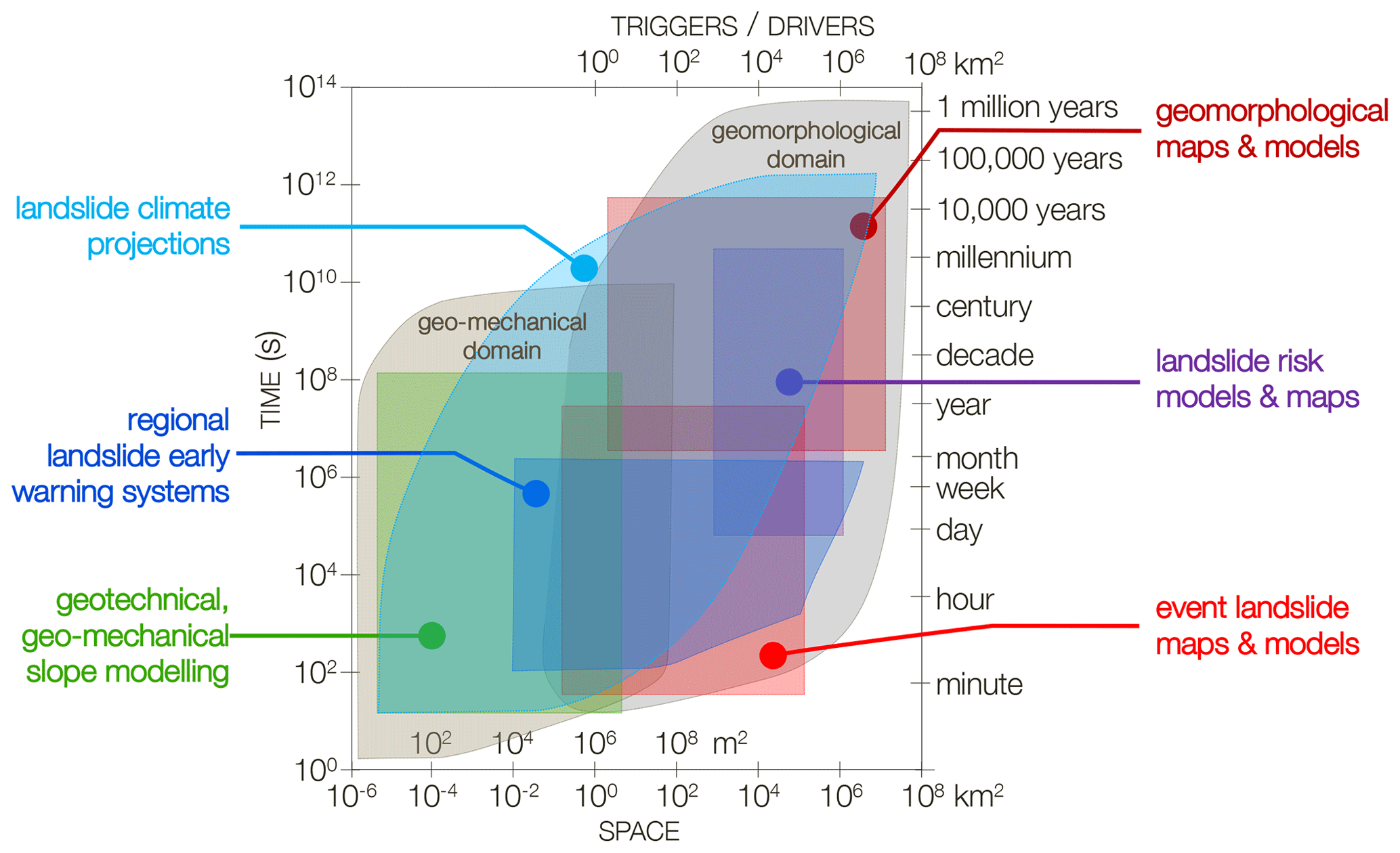
Figure 1Space (lower x axis)–time (y axes) chart showing main geomorphological and geo-mechanical landslide domains, and typical length scale of main meteorological and geophysical triggers and drivers of populations of landslides. Coloured polygons show approximate sub-domains for typical landslide hazards and risk mapping and modelling efforts. Modified after Guzzetti (2021).

Here, I outline what I consider to be the main problems that need to be addressed in order to advance our ability to predict landslide hazards and risk. The field is vast, and I limit my perspective to populations of landslides – that is, the hazards and risk posed by many landslides caused by one triggering event or by multiple events in a short period. In this context, predicting landslide hazard means anticipating where, when, how frequently, how many, and how large populations of landslides are expected (Guzzetti et al., 2005; Lombardo et al., 2020; Guzzetti, 2021). Predicting landslide risk is about anticipating the consequences of landslide populations to different vulnerable elements (Alexander, 2005; Glade et al., 2005; Galli and Guzzetti, 2007; Salvati et al., 2018).

Landslides tend to occur where they have previously occurred (Temme et al., 2020). Therefore, one way to assess where they are expected is to map past and new landslides. The technology is mature for regional and even global landslide detection and mapping services based on the automatic or semi-automatic processing of aerial and satellite imagery: optical, SAR and lidar data (Guzzetti et al., 2012; Mondini et al., 2021). An alternative – and complementary – way is through susceptibility modelling, an approach for which there is no shortage of data-driven methods but rather of suitable environmental and landslide data (Reichenbach et al., 2018). The increasing availability of satellite imagery, some of which repeated over time and free of charge (Aschbacher, 2017), opens up unprecedented opportunities to prepare event and multi-temporal inventory maps covering very large areas, which are essential to build space–time prediction models (Lombardo et al., 2020), to investigate the legacy of old landslides on new ones (Samia et al., 2017; Temme et al., 2020), to obtain accurate thematic data for susceptibility modelling (Reichenbach et al., 2018), and to validate geographical landslide early warning systems (Piciullo et al., 2018; Guzzetti et al., 2020). However, the literature reveals a systematic lack of standards for constructing, validating, and ranking the quality of landslide maps and prediction models (Guzzetti et al., 2012; Mondini et al., 2021; Reichenbach et al., 2018). This reduces the credibility of the maps and models – a gap that urgently needs to be bridged (Guzzetti, 2021).

Predicting when or how frequently landslides will occur can be done for short and for long periods. For short periods – from hours to weeks – the prediction is obtained through process-based models, rainfall thresholds, or their combination. Process-based models rely upon the understanding of the physical laws controlling the slope instability conditions of a landscape forced by a transient trigger, e.g. a rainfall, snow melt, seismic, or volcanic event (Bogaard and Greco, 2016, 2018). The major limitation of physically based models is the scarcity of relevant data, which are hard to obtain for very large areas. New approaches to obtain relevant, spatially distributed data are needed, as well as novel models able to extrapolate what is learned in sample areas to vast territories (Bellugi et al., 2011; Alvioli and Baum, 2016; Alvioli et al., 2018; Mirus et al., 2020).

Thresholds are empirical or statistical models that link physical quantities (e.g. cumulative rainfall, rainfall duration) to the occurrence – or lack of occurrence – of known landslides. Reviews of the literature (Guzzetti et al., 2008; Segoni et al., 2018) have highlighted conceptual problems with the definition and use of rainfall thresholds for operational landslide forecasting and early warning systems (Piciullo et al., 2018; Guzzetti et al., 2020), including the lack of standards for defining the thresholds and their associated uncertainty (Melillo et al., 2018), and for the validation of the threshold models (Piciullo et al., 2017, 2018; Guzzetti et al., 2020). The community needs shared criteria and algorithms coded into open-source software for the objective definition of rainfall events, of the rainfall conditions that can result in landslides, of rainfall thresholds (Melillo et al., 2015, 2018), and for the validation of the threshold models (Piciullo et al., 2017). This will not only provide reliable and comparable thresholds, allowing for regional and global studies (Guzzetti et al., 2008; Segoni et al., 2018), but also increase the credibility of early warning systems based on rainfall threshold models (Guzzetti et al., 2020).

The projection of landslide frequency for long periods – decades to millennia – is much more difficult and uncertain, as it depends on climatic and environmental characteristics that are poorly known and difficult to measure and model (Crozier, 2010; Gariano and Guzzetti, 2016), as well as on the inherent incompleteness of the historical landslide records (Rossi et al., 2010). The literature on the analysis of historical landslide records remains scarce, but the number of studies projecting the future occurrence of landslides is increasing (Gariano et al., 2017; Peres and Cancelliere, 2018; Schlögl and Matulla, 2018; Patton et al., 2019; Schlögel et al., 2020; Gariano and Guzzetti, 2021). In this field, studies will be relevant if they compare analyses and validation methods in different areas. This requires the exchange of data and information.

Predicting how many and how large landslides are expected means anticipating the size (e.g. area, volume, length, width, depth) and number of landslides in an area – with size and number correlated in a population of landslides. This information is obtained by constructing and modelling probability distributions of landslide sizes obtained typically from landslide event inventory maps (Stark and Hovius, 2011; Malamud et al., 2004). The literature on the topic is limited, with differences in the way the distributions are modelled. This hampers comparisons from different areas. Although models have been proposed to explain the probability size distributions (Katz and Aharanov, 2006; Stark and Guzzetti, 2009; Klar et al., 2011; Bellugi et al., 2021), further efforts are needed to explain the observed distributions of landslide sizes and to evaluate their variability and uncertainty.

By combining probabilistic information on where, when or how frequently, and how many or how large landslides are, one can evaluate landslide hazards for different landslide types. However, the existing models are crude, they work under assumptions that are difficult to prove (Guzzetti et al., 2005), and the possibility to export them in different areas is limited or untested. Novel efforts are needed to prepare reliable landslide hazard models (Lombardo et al., 2020; Guzzetti, 2021).

Assessing landslide hazard is important, but for social applications what is needed is the estimation of the landslide consequences, which means assessing the vulnerability to landslides of various elements at risk (Alexander, 2005; Galli and Guzzetti, 2007) and evaluating landslide risk (Cruden and Fell, 1997; Glade et al., 2005; Porter and Morgenstern, 2013), including risk to the population (Petley, 2012; Froude and Petley, 2018; Salvati et al., 2018; Rossi et al., 2019). Here, the main limitation is the difficulty in obtaining data on landslide vulnerability and reliable records of landslide events and their consequences (Petley, 2012; Froude and Petley, 2018; Salvati et al., 2018). Where the information is available, comprehensive landslide risk models can be constructed and validated (Rossi et al., 2019). It is important that efforts are made to collect reliable records of landslides and their consequences and that the records are shared to test different risk models.

Of the various factors governing landslide hazard, the most uncertain and the one requiring more urgent efforts is the time prediction (when, how frequently), followed by the prediction of the size and number of expected failures. For both, multi-temporal inventories and landslide catalogues are essential to build innovative predictive models. To construct the records, systematic efforts are needed for landslide detection and mapping (Mondini et al., 2021). For susceptibility (where), the challenge is to prepare reliable regional, continental, or global assessments (Stanley and Kirschbaum, 2017; Broeckx et al., 2018; Wilde et al., 2018; Mirus et al., 2020). Critical are also novel modelling frameworks combining the hazard factors (Lombardo et al., 2020). But the goal is to reduce risk (Glade et al., 2005). For that, vulnerability studies (Galli and Guzzetti, 2007), improved early warning capabilities (Piciullo et al., 2018; Guzzetti et al., 2020), quantification of the benefits of prevention, and better risk communication strategies are crucial (Guzzetti, 2018). Much work is needed on these largely unexplored subjects.

Ultimately, I note that in medicine – a field of science conceptually close to the field of landslide hazard assessment and risk mitigation (Guzzetti, 2015) – the paradigm of “convergence research” is emerging (Sharp and Hockfield, 2017), where “convergence comes as a result of the sharing of methods and ideas … It is the integration of insights and approaches from historically distinct scientific and technological disciplines” (Sharp et al., 2016). The community of landslide scientists should embrace the paradigm of “converge research”, exploiting the vast number of data, measurements, and observations that are available and will be collected, expanding the making and use of predictions, assessing the economic and social costs of landslides, designing sustainable mitigation and adaptation strategies, and addressing the ethical issues posed by natural hazards, including landslides (Bohle, 2019). I am convinced that this will contribute to advancing knowledge and building a safer society (Guzzetti, 2018).

Data availability

No data sets were used in this article.

Competing interests

The author declares that there is no conflict of interest.

Special issue statement

This article is part of the special issue “Perspectives on challenges and step changes for addressing natural hazards”. It is not associated with a conference.

Acknowledgements

This article, and the many years of work behind it, would not have been possible without the active contribution and ingenuity of many colleagues with whom I have had the fortune to work with, and in particular my colleagues in the geomorphology group at the CNR's Institute for Research on Geo-Hydrological Protection in Perugia.

Review statement

This paper was edited by Heidi Kreibich and reviewed by two anonymous referees.

References

Alexander, E. D.: Vulnerability to landslides, in: Landslide risk assessment, edited by: Glade, T., Anderson, M. G., and Crozier, M. J., John Wiley, Chichester, UK, 175–198, https://doi.org/10.1002/9780470012659.ch5, 2005. 

Alvioli, M. and Baum, R. L.: Parallelization of the TRIGRS model for rainfall-induced landslides using the message passing interface, Environ. Model. Softw,. 81, 122–135, https://doi.org/10.1016/j.envsoft.2016.04.002, 2016.  

Alvioli, M., Melillo, M., Guzzetti, F., Rossi, M., Palazzi, E., von Hardenberg, J., Brunetti, M. T., and Peruccacci, S.: Implications of climate change on landslide hazard in Central Italy, Sci. Total Environ., 630, 1528–1543, https://doi.org/10.1016/j.scitotenv.2018.02.315, 2018. 

Aschbacher, J.: ESA's Earth Observation Strategy and Copernicus, in: Satellite Earth Observations and Their Impact on Society and Policy, chap. 5, edited by: Onoda, M. and Young, O. R., Springer, Singapore, Singapore, 81–86, https://doi.org/10.1007/978-981-10-3713-9_5, 2017. 

Bellugi, D., Dietrich, W. E., Stock, J. D., McKean, J. A., Kazian, B., and Hargrove, P.: Spatially Explicit Shallow Landslide Susceptibility Mapping Over Large Areas, Ital. J. Eng. Geol. Environ., 399–407, https://doi.org/10.4408/IJEGE.2011-03.B-045, 2011. 

Bellugi, D. G., Milledge, D. G., Cuffey, K. M., Dietrich, W. E., and Larsen, L. G.: Controls on the size distributions of shallow landslides, P. Natl. Acad. Sci. USA, 118, e2021855118, https://doi.org/10.1073/pnas.2021855118, 2021. 

Bogaard, T. A. and Greco, R.: Landslide hydrology: from hydrology to pore pressure, Wiley Interdisciplin. Rev.: Water, 3, 439–459, https://doi.org/10.1002/wat2.1126, 2016. 

Bogaard, T. and Greco, R.: Invited perspectives: Hydrological perspectives on precipitation intensity-duration thresholds for landslide initiation: proposing hydro-meteorological thresholds, Nat. Hazards Earth Syst. Sci., 18, 31–39, https://doi.org/10.5194/nhess-18-31-2018, 2018. 

Bohle, M. (Ed.): Exploring Geoethics: Ethical Implications, Societal Contexts, and Professional Obligations of the Geosciences, Springer Int. Pub., Cham, https://doi.org/10.1007/978-3-030-12010-8, 2019. 

Broeckx, J., Vanmaercke, M., Duchateau, R., and Poesen, J.: A data-based landslide susceptibility map of Africa, Earth-Sci. Rev., 185, 102–121, https://doi.org/10.1016/j.earscirev.2018.05.002, 2018. 

Crozier, M. J.: Deciphering the effect of climate change on landslide activity: A review, Geomorphology, 124, 260–267, https://doi.org/10.1016/j.geomorph.2010.04.009, 2010. 

Cruden, D. M. and Fell, R.: Landslide Risk Assessment, CRC Press, Rotterdam, 1997. 

Dawson, A. G., Long, D., and Smith, D. E.: The Storegga slides: evidence from eastern Scotland for a possible tsunami, Mar. Geol., 82, 271–276, https://doi.org/10.1016/0025-3227(88)90146-6, 1988. 

Evans, S. G., Bishop, N. F., Fidel Smoll, L., Valderrama Murillo, P., Delaney, K. B., and Oliver-Smith, A.: A re-examination of the mechanism and human impact of catastrophic mass flows originating on Nevado Huascarán, Cordillera Blanca, Peru in 1962 and 1970, Eng. Geol., 108, 96–118, https://doi.org/10.1016/j.enggeo.2009.06.020, 2009. 

Froude, M. J. and Petley, D. N.: Global fatal landslide occurrence from 2004 to 2016, Nat. Hazards Earth Syst. Sci., 18, 2161–2181, https://doi.org/10.5194/nhess-18-2161-2018, 2018. 

Galli, M. and Guzzetti, F.: Landslide vulnerability criteria: a case study from Umbria, Central Italy, Environ. Manage., 40, 649–665, https://doi.org/10.1007/s00267-006-0325-4, 2007. 

Gariano, S. L. and Guzzetti, F.: Landslides in a changing climate, Earth-Sci. Rev., 162, 227–252, https://doi.org/10.1016/j.earscirev.2016.08.011, 2016. 

Gariano, S. L. and Guzzetti, F.: Mass-Movements and Climate Change, in: Reference Module in Earth Sys. Env. Sci., Elsevier, https://doi.org/10.1016/B978-0-12-818234-5.00043-2, 2021. 

Gariano, S. L., Rianna, G., Petrucci, O., and Guzzetti, F.: Assessing future changes in the occurrence of rainfall-induced landslides at a regional scale, Sci. Total Environ., 596–597, 417–426, https://doi.org/10.1016/j.scitotenv.2017.03.103, 2017. 

Glade, T., Anderson, M. G., and Crozier, M. J. (Eds.): Landslide hazard and risk, John Wiley Sons, Chichester, UK, ISBN 13:978-0471486633, 2005. 

Guzzetti, F.: Forecasting natural hazards, performance of scientists, ethics, and the need for transparency, Toxicol. Environ. Chem., 98, 1043–1059, https://doi.org/10.1080/02772248.2015.1030664, 2015. 

Guzzetti, F.: Rischi naturali: l'urgenza di una scienza nuova, in: Europa: Le sfide della scienza, Europa, edited by: Caporale, C., Maffei, L., Marchis, V., and de Martin, J. C., Istituto della Enciclopedia Italiana, Roma, 127–133, 2018. 

Guzzetti, F.: On the Prediction of Landslides and Their Consequences, in: Understanding and Reducing Landslide Disaster Risk: Volume 1 Sendai Landslide Partnerships and Kyoto Landslide Commitment, edited by: Sassa, K., Mikoš, M., Sassa, S., Bobrowsky, P. T., Takara, K., and Dang, K., Springer International Publishing, Cham, 3–32, https://doi.org/10.1007/978-3-030-60196-6_1, 2021. 

Guzzetti, F., Reichenbach, P., Cardinali, M., Galli, M., and Ardizzone, F.: Probabilistic landslide hazard assessment at the basin scale, Geomorphology, 72, 272–299, https://doi.org/10.1016/j.geomorph.2005.06.002, 2005. 

Guzzetti, F., Peruccacci, S., Rossi, M., and Stark, C. P.: The rainfall intensity–duration control of shallow landslides and debris flows: an update, Landslides, 5, 3–17, https://doi.org/10.1007/s10346-007-0112-1, 2008. 

Guzzetti, F., Mondini, A. C., Cardinali, M., Fiorucci, F., Santangelo, M., and Chang, K.-T.: Landslide inventory maps: New tools for an old problem, Earth-Sci. Rev., 112, 42–66, https://doi.org/10.1016/j.earscirev.2012.02.001, 2012. 

Guzzetti, F., Gariano, S. L., Peruccacci, S., Brunetti, M. T., Marchesini, I., Rossi, M., and Melillo, M.: Geographical landslide early warning systems, Earth-Sci. Rev., 200, 102973, https://doi.org/10.1016/j.earscirev.2019.102973, 2020. 

Hungr, O., Leroueil, S., and Picarelli, L.: The Varnes classification of landslide types, an update, Landslides, 11, 167–194, https://doi.org/10.1007/s10346-013-0436-y, 2014. 

Katz, O. and Aharonov, E.: Landslides in vibrating sand box: What controls types of slope failure and frequency magnitude relations?, Earth Planet. Sci. Lett., 247, 280–294, https://doi.org/10.1007/978-1-4020-4370-3, 2006. 

Klar, A., Aharonov, E., Kalderon-Asael, B., and Katz, O.: Analytical and observational relations between landslide volume and surface area, J. Geophys. Res., 116, F02001, https://doi.org/10.1029/2009JF001604, 2011. 

Lombardo, L., Opitz, T., Ardizzone, F., Guzzetti, F., and Huser, R.: Space-time landslide predictive modelling, Earth-Sci. Rev., 209, 103318, https://doi.org/10.1016/j.earscirev.2020.103318, 2020. 

Malamud, B. D., Turcotte, D. L., Guzzetti, F., and Reichenbach, P.: Landslide inventories and their statistical properties, Earth Surf. Proc. Land., 29, 687–711, https://doi.org/10.1002/esp.1064, 2004. 

Melillo, M., Brunetti, M. T., Peruccacci, S., Gariano, S. L., and Guzzetti, F.: An algorithm for the objective reconstruction of rainfall events responsible for landslides, Landslides, 12, 311–320, https://doi.org/10.1007/s10346-014-0471-3, 2015. 

Melillo, M., Brunetti, M. T., Peruccacci, S., Gariano, S. L., Roccati, A., and Guzzetti, F.: A tool for the automatic calculation of rainfall thresholds for landslide occurrence, Environ. Model. Softw., 105, 230–243, https://doi.org/10.1016/j.envsoft.2018.03.024, 2018. 

Mirus, B. B., Jones, E. S., Baum, R. L., Godt, J. W., Slaughter, S., Crawford, M. M., Lancaster, J., Stanley, T., Kirschbaum, D. B., Burns, W. J., Schmitt, R. G., Lindsey, K. O., and McCoy, K. M.: Landslides across the USA: occurrence, susceptibility, and data limitations, Landslides, 17, 2271–2285, https://doi.org/10.1007/s10346-020-01424-4, 2020. 

Mondini, A. C., Guzzetti, F., Chang, K.-T., Monserrat, O., Martha, T. R., and Manconi, A.: Landslide failures detection and mapping using Synthetic Aperture Radar: Past, present and future, Earth-Sci. Rev., 216, 103574, https://doi.org/10.1016/j.earscirev.2021.103574, 2021. 

Papale, P. and Marzocchi, W.: Volcanic threats to global society, Science, 363, 1275–1276, https://doi.org/10.1126/science.aaw7201, 2019. 

Patton, A. I., Rathburn, S. L., and Capps, D. M.: Landslide response to climate change in permafrost regions, Geomorphology, 340, 116–128, https://doi.org/10.1016/j.geomorph.2019.04.029, 2019. 

Peres, D. J. and Cancelliere, A.: Modeling impacts of climate change on return period of landslide triggering, J. Hydrol., 567, 420–434, https://doi.org/10.1016/j.jhydrol.2018.10.036, 2018. 

Petley, D.: Global patterns of loss of life from landslides, Geology, 40, 927–930, https://doi.org/10.1130/g33217.1, 2012. 

Piciullo, L., Gariano, S. L., Melillo, M., Brunetti, M. T., Peruccacci, S., Guzzetti, F., and Calvello, M.: Definition and performance of a threshold-based regional early warning model for rainfall-induced landslides, Landslides, 14, 995–1008, https://doi.org/10.1007/s10346-016-0750-2, 2017. 

Piciullo, L., Calvello, M., and Cepeda, J. M.: Territorial early warning systems for rainfall-induced landslides, Earth-Sci. Rev., 179, 228–247, https://doi.org/10.1016/j.earscirev.2018.02.013, 2018. 

Porter, M. and Morgenstern, N.: Landslide risk evaluation – Canadian technical guidelines and best practices related to landslides: a national initiative for loss reduction, Open File 7312, Geological Survey of Canada, p. 21, https://doi.org/10.4095/292234, 2013. 

Reichenbach, P., Rossi, M., Malamud, B. D., Mihir, M., and Guzzetti, F.: A review of statistically-based landslide susceptibility models, Earth-Sci. Rev., 180, 60–91, https://doi.org/10.1016/j.earscirev.2018.03.001, 2018. 

Rossi, M., Witt, A., Guzzetti, F., Malamud, B. D., and Peruccacci, S.: Analysis of historical landslide time series in the Emilia-Romagna region, northern Italy, Earth Surf. Proc. Land., 35, 1123–1137, https://doi.org/10.1002/esp.1858, 2010. 

Rossi, M., Guzzetti, F., Salvati, P., Donnini, M., Napolitano, E., and Bianchi, C.: A predictive model of societal landslide risk in Italy, Earth-Sci. Rev., 196, 102849, https://doi.org/10.1016/j.earscirev.2019.04.021, 2019.  

Salvati, P., Petrucci, O., Rossi, M., Bianchi, C., Pasqua, A. A., and Guzzetti, F.: Gender, age and circumstances analysis of flood and landslide fatalities in Italy, Sci. Total Environ., 610–611, 867–879, https://doi.org/10.1016/j.scitotenv.2017.08.064, 2018. 

Samia, J., Temme, A. J. A. M., Bregt, A., Wallinga, J., Guzzetti, F., Ardizzone, F., and Rossi, M.: Do landslides follow landslides? Insights in path dependency from a multi-temporal landslide inventory, Landslides, 14, 547–558, https://doi.org/10.1007/s10346-016-0739-x, 2017. 

Schlögl, M. and Matulla, C.: Potential future exposure of European land transport infrastructure to rainfall-induced landslides throughout the 21st century, Nat. Hazards Earth Syst. Sci., 18, 1121–1132, https://doi.org/10.5194/nhess-18-1121-2018, 2018. 

Schlögel, R., Kofler, C., Gariano, S. L., Campenhout, J. V., and Plummer, S.: Changes in climate patterns and their association to natural hazard distribution in South Tyrol (Eastern Italian Alps), Scient. Rep., 10, 5022, https://doi.org/10.1038/s41598-020-61615-w, 2020. 

Segoni, S., Piciullo, L., and Gariano, S. L.: A review of the recent literature on rainfall thresholds for landslide occurrence, Landslides, 15, 1483–1501, https://doi.org/10.1007/s10346-018-0966-4, 2018. 

Sharp, P. and Hockfield, S.: Convergence: The future of health, Science, 355, 589, https://doi.org/10.1126/science.aam8563, 2017. 

Sharp, P., Jacks, T., and Hockfield, S.: Convergence: the future of health, ConvergenceRevolution.net, Cambridge, Massachusetts, 2016. 

Stanley, T. and Kirschbaum, D.: A heuristic approach to global landslide susceptibility mapping, Nat. Hazards, 87, 145–164, https://doi.org/10.1007/s11069-017-2757-y, 2017. 

Stark, C. P. and Guzzetti, F.: Landslide rupture and the probability distribution of mobilized debris volumes, J. Geophy. Res., 114, F00A02, https://doi.org/10.1029/2008JF001008, 2009. 

Stark, C. P. and Hovius, N.: The characterization of landslide size distributions, Geophy. Res. Lett., 28, 1091–1094, https://doi.org/10.1029/2000gl008527, 2001. 

Temme, A., Guzzetti, F., Samia, J., and Mirus, B. B.: The future of landslides' past – a framework for assessing consecutive landsliding systems, Landslides, 17, 1519–1528, https://doi.org/10.1007/s10346-020-01405-7, 2020. 

Wieczorek, G. F., Larsen, M. C., Eaton, L. S., Morgan, B. A., and Blair, J. L.: Debris-flow and flooding hazards associated with the December 1999 storm in coastal Venezuela and strategies for mitigation, US Geological Survey Open File Report 01-0144, US Geological Survey, available at: https://pubs.usgs.gov/of/2001/ofr-01-0144/ (last access: 7 May 2021), 2001. 

Wilde, M., Günther, A., Reichenbach, P., Malet, J.-P., and Hervás, J.: Pan-European landslide susceptibility mapping: ELSUS Version 2, J. Maps, 14, 97–104, https://doi.org/10.1080/17445647.2018.1432511, 2018. 

Wolpert, D. H.: Computational capabilities of physical systems, Phys. Rev. E, 65, 016128,https://doi.org/10.1103/PhysRevE.65.016128, 2001. 

Short summary
This is a perspective based on personal experience on whether a large number of landslides caused by a single trigger (e.g. an earthquake, an intense rainfall, a rapid snowmelt event) or by multiple triggers in a period can be predicted, in space and time, considering the consequences of slope failures.
Altmetrics
Final-revised paper
Preprint