the Creative Commons Attribution 4.0 License.
the Creative Commons Attribution 4.0 License.
 | 10 Feb 2025
Causes of the exceptionally high number of fatalities in the Ahr valley, Germany, during the 2021 flood
Belinda Rhein
Over the last 40 years (1980–2020), 159 people died in inland floods in Germany. The flood of 2021 caused 190 flood fatalities in Germany, 134 of them in the Ahr valley. We investigate what made this event so deadly in order to help improve flood risk management and prevent future fatalities. A comprehensive analysis of the factors influencing the occurrence of fatalities is carried out on the basis of the death investigation files of the public prosecutor's office. This unprecedented flash flood was characterised by high water levels and high flow velocities. The extent of inundation in 2021 far exceeded the official hazard map for the extreme flood scenario. Additionally, early warning and evacuation were inadequate, so many people were surprised by the flash flood. Of the total fatalities, 75 % occurred outside of the mapped hazard zones. Particularly dangerous places were campsites, cellars and basement flats, but many people died on the ground floor (37 %) or outside on the street (18 %). The elderly above 60 years of age (78 %) and those with mobility or cognitive impairments (16 %) were particularly vulnerable. No gender-specific differences in vulnerability were observed. Thus, the main causes for the exceptionally high number of fatalities were the extreme severity of the flood and its underestimation by the population and authorities, as well as inadequate early warning and evacuation. Consequently, public understanding of the particular danger posed by flash floods must be improved, as must the development and presentation of worst-case scenarios in hazard maps. Additionally, impact forecasting can significantly improve emergency management of such unprecedented floods. Specific recommendations for disaster management are (1) that in the event of such extreme flash floods, the warning messages must focus on saving human lives – i.e. those at risk must be advised to move to safe places, e.g. to the upper floors, instead of trying to save belongings – and (2) evacuations must be initiated in good time, especially where flooding of the ground floor with high water levels is to be expected, paying particular attention to the safety of the elderly and people with limited mobility.
- Article
(2440 KB) - Full-text XML
- BibTeX
- EndNote


-
With 190 fatalities, 134 of them in the Ahr valley, the 2021 event was the deadliest flood in recent German history.
-
Many people died on the ground floor (37 %) or outside on the street (18 %); the elderly over the age of 60 were particularly vulnerable (78 %).
-
Before extreme flash floods, warnings must make it clear that saving lives takes priority and evacuations must be carried out in good time, paying particular attention to the elderly.
The flood of July 2021 can be described as an unprecedented flash flood (Kreibich et al., 2022) with a particularly high number of deaths, including 134 fatalities in the Ahr valley in Germany (Koks et al., 2022). The term “unprecedented” is used here in a subjective sense; i.e. local residents and authorities had never experienced a flood with a similar severity and number of fatalities (Kreibich et al., 2022). The number of fatalities is exceptionally high for Germany, with the most recent deadliest floods causing 11 deaths in 2016, 14 in 2013, and 21 in 2002 (Papagiannaki et al., 2022). In the context of inland floods in Germany, fewer people died in the last 40 years between 1980 and 2020, with 159 victims (Petrucci et al., 2022), than in this single flood event in July 2021, with 190 victims (Fig. 1).
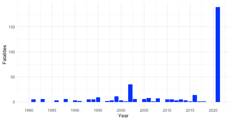
Figure 1Fatalities in inland floods in Germany (1980–2021) according to Petrucci et al. (2022) and 2021 event added.
Detailed knowledge about the causes of flood fatalities is scarce, due to a lack of data. Most often only the number of fatalities is available, sometimes including information on gender and age (Kellar and Schmidlin, 2012; Paul and Mahmood, 2016; Pereira et al., 2017; Sharif et al., 2012). Exceptions include Thieken et al. (2023a) analysing the flood fatalities in North Rhine-Westphalia for the same flood in great detail. They found that the elderly were particularly vulnerable, with lack of warning and lack of flood awareness being the main causes of flood fatalities. By accessing police statements and forensic reports, Ahmed et al. (2020) were able to analyse vehicle-related flood fatalities in Australia between 2001 and 2017. They identified middle-aged and elderly males as the most common fatalities as drivers, while young women and children were most vulnerable as passengers (Ahmed et al., 2020). Diakakis and Deligiannakis (2017) developed a detailed database of more than 150 flood fatalities that occurred in Greece between 1970 and 2010 and found that accidents mostly occurred at night outdoors in rural areas, with men and the elderly as most vulnerable and vehicle-related fatalities as the most common.
Hydrologically, the 2021 flood was extreme in terms of the rapid onset of flooding, high flow velocities, high water levels and large inundation extent. Between 12 and 19 July 2021, the low-pressure system “Bernd” resulted in extreme rainfall of more than 150 mm in 72 h (Mohr et al., 2023). The high rainfall on already saturated soils led to surface runoff, especially along the narrow valley of the river Ahr (Kron et al., 2022). Water levels started rising between 08:00 and 10:00 LT on 14 July and peaked at around 20:00 to 22:00 LT on the same day at the Müsch gauge upstream on the Ahr (Fig. 2). Further downstream, gauges showed peak water levels during the night and in the early morning of 15 July, namely at the Altenahr gauge between 00:00 and 01:00 LT (Mohr et al., 2023).
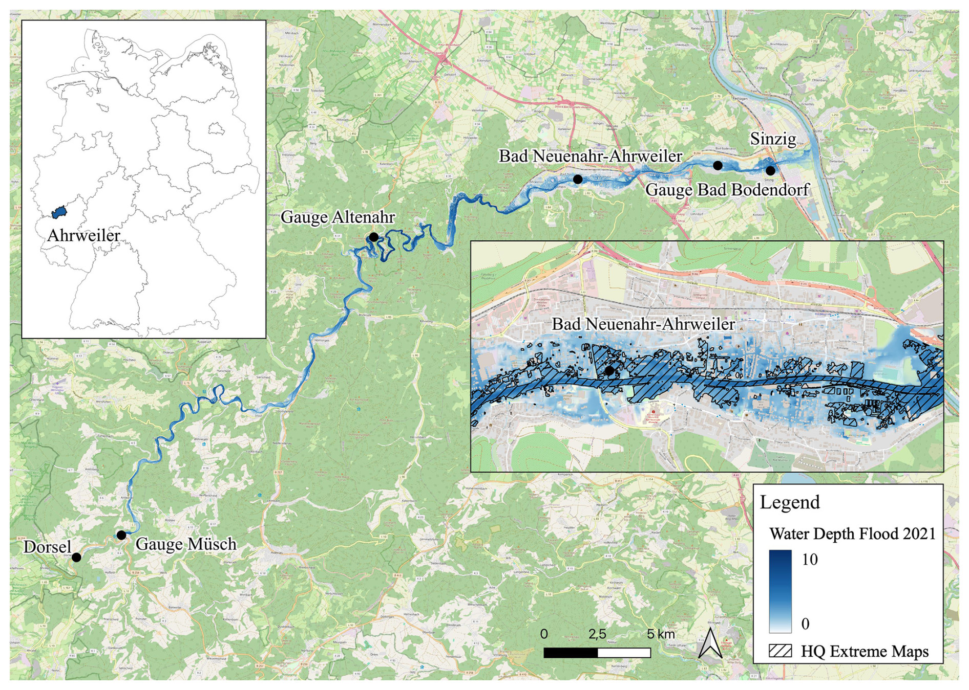
Figure 2Study site along the Ahr with gauges (Landesamt für Umwelt Rheinland-Pfalz, 2016), water depths of the 2021 flood (Apel et al., 2022) and the HQ Extreme Maps data of 2018 for Bad Neuenahr-Ahrweiler (Ministerium für Klimaschutz, Umwelt, Energie und Mobilität Rheinland-Pfalz, 2018). © OpenStreetMap contributors 2024. Distributed under the Open Data Commons Open Database License (ODbL) v1.0.
The official hazard map available in July 2021 for the extreme flood scenario for the Ahr valley significantly underestimated the inundation area of the 2021 flood (Fig. 2). The hazard map was calculated on the basis of the flow records from 1947, when the continuous recording of water levels had begun but which did not include such extreme events (Kron et al., 2022). There had been warnings issued by the German meteorological service starting on 11 July 2021 about the potentially flood-triggering low-pressure system. The forecast that was published 24 h before the event suggested a maximum water depth of 5.74 m at the gauge in Altenahr, while reconstructions of the event show that the peak water levels were at about 10.2 m (Apel et al., 2022). The district of Ahrweiler released a flood warning on 14 July 2021 in the early afternoon (Thieken et al., 2023b). At 23:09 LT on 14 July, a state of emergency was declared in the municipality of Altenahr and residents within 50 m on either side of the Ahr were asked to evacuate, although the floodwater was already dangerously high at this time (Thieken et al., 2023b). The local authorities apparently underestimated the flood, and the official warnings did not convey the extreme severity of the impending flood. Thieken et al. (2023b) showed that 29 % of those affected by the 2021 flood in Rhineland-Palatinate had not received any warning.
The 2021 flood was also extreme in terms of its consequences, with 190 fatalities and economic losses of around EUR 33 billion (Kron et al., 2022; Munich Re, 2022); EUR 20 billion of these losses were in Rhineland-Palatinate (DKKV, 2022). Around 42 000 inhabitants were affected by the flood along the Ahr, and around 8800 buildings were damaged (DKKV, 2022). More than 475 buildings were completely destroyed or had to be demolished due to the severity of the damage, including 200 residential buildings (Kron et al., 2022).
The last significant flood event on the Ahr before 2021 was in June 2016, but with a water level of 3.71 m at the Altenahr gauge and no fatalities, the flood was significantly less extreme than that of 2021 (Landesamt für Umwelt Rheinland-Pfalz, 2016). A flood of a magnitude similar to the one in 2021 occurred at the Ahr in 1804 (Roggenkamp and Hergert, 2022). However, this event was too long ago for the local population and authorities to actively remember it. The reconstructed discharge at the Altenahr gauge for 1804 was 1090 m3 s−1, which is assumed to be similar to the peak discharge for the July 2021 flood; peak water level in 1804 was estimated to have been 7.29 m (Vorogushyn et al., 2022). Reconstructions for the Altenahr gauge suggest a maximum water depth of 10.2 m in July 2021 (Apel et al., 2022).
The objective of this study is a particularly detailed analysis of the flood fatalities in the Ahr valley in 2021 based on the death investigation files of the public prosecutor's office. The analysis is structured according to the risk concept into hazard, exposure and vulnerability factors (United Nations Office for Disaster Risk Reduction, 2015). The analysis intends to improve our knowledge on the causes of flood fatalities in order to support flood risk management and prevent future fatalities.
The data for this analysis are the death investigation files from the public prosecutor's office in Koblenz, Rhineland-Palatinate, Germany. One file per flood fatality in the Ahr valley in July 2021 was analysed, i.e. 134 files. The files include a description of the victims including age, gender, and sometimes health aspects. In many cases, they contain conversation transcripts with witnesses who describe the course of the accident, and they provide details about the circumstances of the death. No autopsies were performed for the flood fatalities, and death by drowning was presumed, making it impossible to analyse the medical cause of death. The accident location and location of discovery are included in the police reports, as well as the time and day of the discovery of the body.
The data were anonymised and classified according to the coding system of Thieken et al. (2023a). The coding system covers the following aspects: gender, age, nationality, mobility and cognitive impairment, location of accident, location of discovery, time of day, temporal relationship to event, personal relationship to location, activity, accident dynamics, and medical cause of death. For quality control, the coding was carried out independently by two people. The coding results were compared, and, in the event of discrepancies, the information in the files was checked again in detail, its interpretation discussed, and the most likely class assigned.
Accident locations provided in the files were geocoded. In 19 % of the cases, only the place of discovery is known; these cases were excluded from the analysis.
Accident locations were overlaid with the official hazard map for an extreme event available in July 2021 (Ministerium für Klimaschutz, Umwelt, Energie und Mobilität Rheinland-Pfalz, 2021) as well as with the reconstructed flood maps by Apel et al. (2022) that provide flow velocity and water depth, using QGIS. For the indoor accident locations, the maximum water depth and flow velocity directly outside the building were recorded.
3.1 Hazard factors
The probability of fatal accidents during floods increases with more severe hazard. The simulated maximum water depth and flow velocities at the accident locations were high, with 73 % of the 109 analysed cases experiencing more than 2 m of water depth and 32 % of cases more than 1 m s−1 flow velocity (Fig. 3). Both water depth and flow velocity were extreme, with more than 10 m of water depth estimated at the Altenahr gauge (Apel et al., 2022). The hazard pattern differs between the indoor and outdoor locations, as flow velocity outside the building may not have played a role in accidents that happened inside the building. Even relatively shallow water depths on the outside can lead to fatal accidents in cellars if the water enters the building. However, many indoor accident locations had particularly high water levels of more than 4 m (32 % of all indoor cases), so fatalities occurred on the ground floor and upper floors (Fig. 3). Of all indoor accidents, 11 % happened in cellars, 37 % on the ground floor and 5 % on higher floors (Fig. 5).
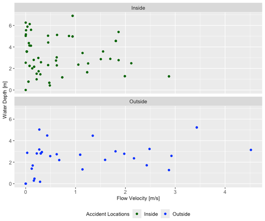
Figure 3Scatterplots of reconstructed water depth and flow velocity (Apel et al., 2022) at inside and outside locations. The analysis excludes one accident location (6 fatalities) upstream in Dorsel, which is not covered by the reconstructed water depth and flow velocity maps (Apel et al., 2022) and cases where the accident location is unknown (19 fatalities).
Accident locations outdoors were more often associated with high flow velocity, with the maximum at 4.5 m s−1 (Fig. 3). The hazard pattern for outdoor cases shows that people died at shallower water depths where the flow velocity was high. The combined hazard severity of water level multiplied by flow velocity is decisive for destabilising people standing in the floodwater. The critical value for human instability is estimated at 1 m2 s−1 (Jonkman and Penning-Rowsell, 2008; Apel et al., 2022).
In addition to the severity of the hazard, other factors such as exposure and vulnerability characteristics can also influence fatal accidents; corresponding results based on analyses of the fatality records are presented in the following sections. To gain further information from a different perspective, it would also be interesting to analyse control groups, i.e. to compare why deaths occurred in one situation and not in a comparable situation. For example, one could analyse hazard hotspots with and without fatalities to determine how people survive in extremely dangerous conditions. However, this approach is out of the scope of our study.
3.2 Exposure factors
The accident locations analysed in relation to the official hazard map for the extreme scenario (Ministerium für Klimaschutz, Umwelt, Energie und Mobilität Rheinland-Pfalz, 2018) reveal that 75 % of the fatalities occurred outside of the mapped hazard zones (Fig. 4). The inundation extent and water depth of the unprecedented flash flood in 2021 far exceeded the extreme scenario of the official hazard maps (Fig. 2). Considering that official hazard maps are used to decide on evacuations and emergency responses, the inaccuracy of the maps may have led to sub-optimal decisions (Kron et al., 2022). They probably gave a false sense of security for areas outside the mapped extreme flood scenario. We therefore recommend improving the development and presentation of worst-case scenarios for official hazard maps (Merz et al., 2024). Additionally, expanding the use of impact forecasting, i.e. warnings of inundation (water depth, flow velocity), blocked roads or damage hotspots, can significantly improve emergency management of unprecedented floods (Rözer et al., 2021; Apel et al., 2022).
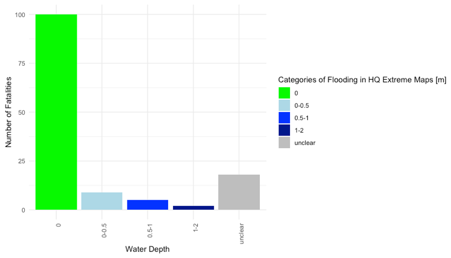
Figure 4Accident locations in relation to the HQ Extreme Maps (Ministerium für Umwelt, Energie und Mobilität Rheinland-Pfalz, 2018) categorised in classes of metres of flooding.
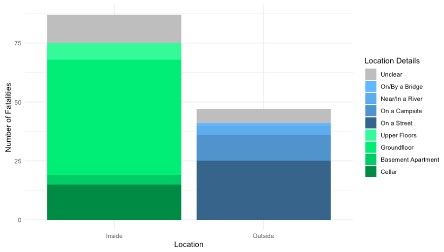
Most of the fatal accidents, 65 %, occurred indoors, which is probably related to the fact that the flood peak was reached between 01:00 and 02:00 LT in Bad Neuenahr-Ahrweiler and Sinzig, where most of the fatalities occurred (Mohr et al., 2023). The lack of warning and timely evacuation played a role as well (Thieken et al., 2023b). Of all indoor accidents, 11 % happened in cellars and 3 % in basement apartments (Fig. 4), particularly dangerous locations during flooding. Cellars can become traps, as even the pressure of small amounts of water can make it impossible to open the cellar door again. Flash flood emergency communication should clearly recommend not going into the cellar to check the heating or safe belongings, which is suggested before slowly rising river floods with sufficient time for emergency action (Kreibich et al., 2021). Basement apartments can make it difficult for the residents to take refuge on higher floors. However, at 37 %, most indoor accidents occurred on the ground floor, and some even occurred on higher floors (5 %), locations which are commonly not perceived as being particularly dangerous (Fig. 4).
The campsite location in Dorsel was the first accident location along the Ahr where fatalities occurred, even when the flood had not reached its peak yet. According to newspaper reports, the campsite flooded at around 16:00 LT on 14 July without the residents having received warning or evacuation messages (FOCUS online, 2022). They were highly exposed as their mobile homes offered no protection from the floods. Campsites are generally considered dangerous places during floods, as people are not only highly exposed, but also often non-residents, less aware of local conditions and news and more difficult to reach with warnings (Terti et al., 2017; Aceto et al., 2017). However, at 18 %, most outside accidents simply occurred on a street (Fig. 5), a place that is not expected to be particularly dangerous, unlike places near a river or a bridge.
3.3 Vulnerability factors
During the flood in the Ahr valley, the elderly were particularly vulnerable. Of the total victims, 80 % were aged 60 or over (Fig. 6). In contrast, most flood victims in Europe between 1980 and 2018 were between 30 and 64 years old (Petrucci, 2022). Compared to the total population of the federal state of Rhineland-Palatinate, Germany, the proportion of elderly people who died during the floods is significantly higher than the proportion of the total population. This high vulnerability of the elderly might be due to their physical limitations and difficulties in moving to higher storeys. Petrucci et al. (2019) showed that fatal accidents with older people commonly occur indoors at home. Men over the age of 70 appear to be particularly vulnerable due to their high susceptibility to trauma (Kellar and Schmidlin, 2012). However, no gender-specific differences in vulnerability were observed. Of the total victims, 49 % were male and 51 % were female (Fig. 6), which matches the gender distribution of the total population of Rhineland-Palatinate in December 2020 (Statistisches Landesamt Rheinland-Pfalz, 2020). This is consistent with previous findings of balanced gender distributions of fatalities in flash floods, where most victims were surprised by the floods (Petrucci, 2022). In other flood situations, previous findings show that a higher proportion of men die, as vehicle-related accidents and risky behaviour, including rescue operations, are more likely to play a role (Sharif et al., 2012).
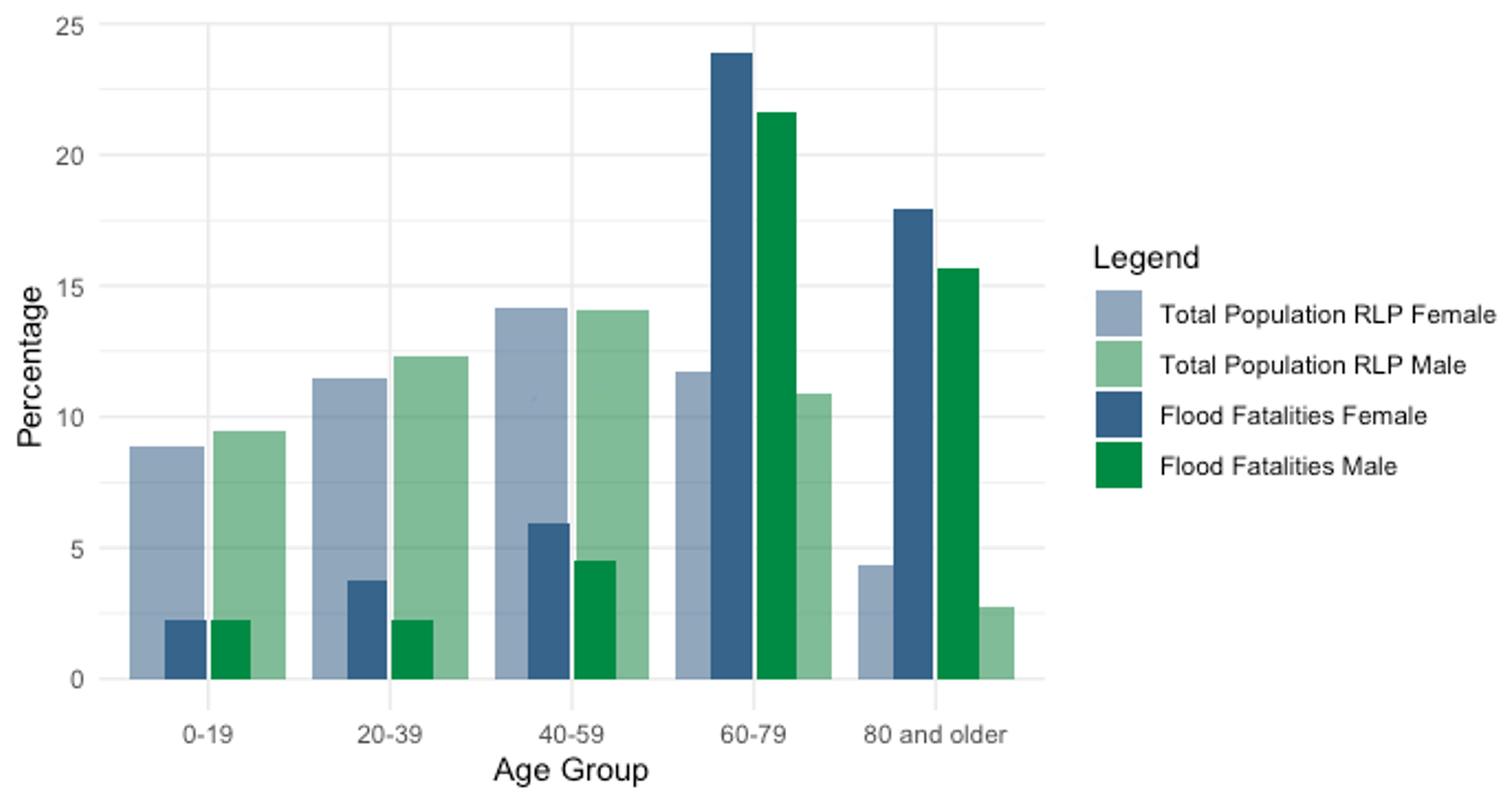
Figure 6Age distribution by gender for the July 2021 flood fatalities and the total population of Rhineland-Palatinate (Statistisches Landesamt Rheinland-Pfalz, 2020).
Of the total flood victims, 16 % had a disability. There were records of mobility impairments for 7 victims, while 14 were recorded as having cognitive impairments. This high number is due to fatalities that occurred in a residential home for adults with mental disabilities. There are relatively few studies that investigate disabilities of flood victims; however, there is one report from Italy in 2000, where 13 people with mobility impairments died at a campsite during the flood (Aceto et al., 2017). Thus, it is important to pay particular attention to these groups during evacuations, e.g. by giving special attention to hospitals, retirement homes and homes for the disabled.
To minimise the number of fatalities from flooding, our recommendation is to improve risk management of unprecedented flash floods (Kreibich et al., 2022), as 75 % of the fatalities occurred outside of the officially mapped hazard zones. The development of worst-case scenarios needs to be improved, including better presentation of extreme events in hazard maps (Merz et al., 2024), so that decision-makers and the public can better prepare for such extreme events. Additionally, impact forecasting can significantly improve emergency management of unprecedented floods (Apel et al., 2022). Public understanding of the particular risk of extreme flash floods must be improved through risk communication, in particular by raising awareness of dangerous locations, behaviours and vulnerable groups. Campsites, cellars and basement flats are identified as particularly dangerous places during floods (Terti et al., 2017; Aceto et al., 2017; Papagiannaki et al., 2022). However, during the 2021 flood, many also died on the ground floor and in the street, places that are not normally considered particularly dangerous. Thus, in the specific case of an extreme flash flood, the focus of emergency communication needs to on saving human lives. Warning messages must clearly communicate that those at risk should move to a safe place or, when it may be too late to leave the building, to go to an upper floor. Elderly people and people with cognitive or mobility impairments are particularly vulnerable. It is therefore important to pay particular attention to these groups during evacuations, e.g. by giving special attention to hospitals, retirement homes and homes for the disabled.
Parts of the anonymised flood fatality data may be obtained upon request.
BR: conceptualisation, data curation, formal analysis, visualisation, writing (original draft, review and editing). HK: conceptualisation, writing (review and editing), supervision.
At least one of the (co-)authors is a member of the editorial board of Natural Hazards and Earth System Sciences. The peer-review process was guided by an independent editor, and the authors also have no other competing interests to declare.
Publisher's note: Copernicus Publications remains neutral with regard to jurisdictional claims made in the text, published maps, institutional affiliations, or any other geographical representation in this paper. While Copernicus Publications makes every effort to include appropriate place names, the final responsibility lies with the authors.
This article is part of the special issue “Strengthening climate-resilient development through adaptation, disaster risk reduction, and reconstruction after extreme events”. It is not associated with a conference.
We would like to thank the public prosecutor's office for allowing us to analyse the death investigation files related to the 2021 flood in anonymised form. We thank Rumyana Zimmer and Astrid Krahn for their work on data coding and quality control.
This research has been supported by the Bundesministerium für Bildung und Forschung within the framework of the KAHR and AVOSS projects (grant nos. FKZ 01LR2102F and FKZ 02WEE1629C).
The article processing charges for this open-access publication were covered by the GFZ Helmholtz Centre for Geosciences.
This paper was edited by Animesh Gain and reviewed by Katerina Papagiannaki and Karin M. de Bruijn.
Aceto, L., Pasqua, A. A., and Petrucci, O.: Effects of damaging hydrogeological events on people throughout 15 years in a Mediterranean region, Adv. Geosci., 44, 67–77, https://doi.org/10.5194/adgeo-44-67-2017, 2017.
Ahmed, M. A., Haynes, K., and Taylor, M.: Vehicle-related flood fatalities in Australia, 2001–2017, J. Flood Risk Manage., 13, e12616, https://doi.org/10.1111/jfr3.12616, 2020.
Apel, H., Vorogushyn, S., and Merz, B.: Brief communication: Impact forecasting could substantially improve the emergency management of deadly floods: case study July 2021 floods in Germany, Nat. Hazards Earth Syst. Sci., 22, 3005–3014, https://doi.org/10.5194/nhess-22-3005-2022, 2022.
Diakakis, M. and Deligiannakis, G.: Flood fatalities in Greece: 1970–2010, J. Flood Risk Manage., 10, 115–123, https://doi.org/10.1111/jfr3.12166, 2017.
DKKV: Opfer- und Schadensdaten der Flut 2021 in Rheinland-Pfalz, German Committee for Disaster Reduction, 1–4, https://dkkv.org/wp-content/uploads/2023/02/Anfrage_Opfer-_und_Schadensdaten_der_Flut_2021.pdf (last access: 4 February 2025), 2022.
FOCUS online: Sieben Camper sterben bei Flut: Jetzt erheben Gäste schwere Vorwürfe gegen Besitzer, FOCUS online, 19 March 2022, https://www.focus.de/politik/gerichte-in-deutschland/campingplatz-stahlhuette_id_70026250.html (last access: 4 February 2025), 2022.
Jonkman, S. N. and Penning-Rowsell, E.: Human Instability in Flood Flows, J. Am. Water Resour. Assoc., 44, 1208–1218, https://doi.org/10.1111/j.1752-1688.2008.00217.x, 2008.
Kellar, D. M. M. and Schmidlin, T. W.: Vehicle-related flood deaths in the United States, 1995–2005, J. Flood Risk Manage., 5, 153–163, https://doi.org/10.1111/j.1753-318X.2012.01136.x, 2012.
Koks, E. E., van Ginkel, K. C. H., van Marle, M. J. E., and Lemnitzer, A.: Brief communication: Critical infrastructure impacts of the 2021 mid-July western European flood event, Nat. Hazards Earth Syst. Sci., 22, 3831–3838, https://doi.org/10.5194/nhess-22-3831-2022, 2022.
Kreibich, H., Hudson, P., and Merz, B.: Knowing What to Do Substantially Improves the Effectiveness of Flood Early Warning, B. Am. Meteorol. Soc., 102, E1450–E1463, https://doi.org/10.1175/BAMS-D-20-0262.1, 2021.
Kreibich, H., Van Loon, A. F., Schröter, K., Ward, P. J., Mazzoleni, M., Sairam, N., Abeshu, G. W., Agafonova, S., AghaKouchak, A., Aksoy, H., Alvarez-Garreton, C., Aznar, B., Balkhi, L., Barendrecht, M. H., Biancamaria, S., Bos-Burgering, L., Bradley, C., Budiyono, Y., Buytaert, W., Capewell, L., Carlson, H., Cavus, Y., Couasnon, A., Coxon, G., Daliakopoulos, I., de Ruiter, M. C., Delus, C., Erfurt, M., Esposito, G., François, D., Frappart, F., Freer, J., Frolova, N., Gain, A. K., Grillakis, M., Grima, J. O., Guzmán, D. A., Huning, L. S., Ionita, M., Kharlamov, M., Khoi, D. N., Kieboom, N., Kireeva, M., Koutroulis, A., Lavado-Casimiro, W., Li, H.-Y., Llasat, M. C., Macdonald, D., Mård, J., Mathew-Richards, H., McKenzie, A., Mejia, A., Mendiondo, E. M., Mens, M., Mobini, S., Mohor, G. S., Nagavciuc, V., Ngo-Duc, T., Thao Nguyen Huynh, T., Nhi, P. T. T., Petrucci, O., Nguyen, H. Q., Quintana-Seguí, P., Razavi, S., Ridolfi, E., Riegel, J., Sadik, M. S., Savelli, E., Sazonov, A., Sharma, S., Sörensen, J., Arguello Souza, F. A., Stahl, K., Steinhausen, M., Stoelzle, M., Szalińska, W., Tang, Q., Tian, F., Tokarczyk, T., Tovar, C., Tran, T. V. T., Van Huijgevoort, M. H. J., van Vliet, M. T. H., Vorogushyn, S., Wagener, T., Wang, Y., Wendt, D. E., Wickham, E., Yang, L., Zambrano-Bigiarini, M., Blöschl, G., and Di Baldassarre, G.: The challenge of unprecedented floods and droughts in risk management, Nature, 608, 80–86, https://doi.org/10.1038/s41586-022-04917-5, 2022.
Kron, W., Bell, R., Thiebes, B., and Thieken, A.: The July 2021 flood disaster in Germany, in: HELP Global Report on Water and Disasters, HELP – High-level Experts and Leaders Panel on Water and Disasters, 12–44, https://www.researchgate.net/publication/365375445_The_July_2021_flood_disaster_in_Germany (last access: 4 February 2025), 2022.
Landesamt für Umwelt Rheinland-Pfalz: Hochwasservorhersagezentrale Rheinland-Pfalz, https://www.hochwasser.rlp.de/static/shared/documents/bericht_starkregen_hochwasser_juni2016.pdf (last access: 4 February 2025), 2016.
Merz, B., Nguyen, V. D., Guse, B., Han, L., Guan, X., Rakovec, O., Samaniego, L., Ahrens, B., and Vorogushyn, S.: Spatial counterfactuals to explore disastrous flooding, Environ. Res. Lett., 19, 044022, https://doi.org/10.1088/1748-9326/ad22b9, 2024.
Ministerium für Klimaschutz, Umwelt, Energie und Mobilität Rheinland-Pfalz: Kartendienste – Wasserportal Hochwassergefahrenkarte Rheinland-Pfalz (2018), https://wasserportal.rlp-umwelt.de/servlet/is/2026/ (last access: 1 June 2021), 2018.
Ministerium für Klimaschutz, Umwelt, Energie und Mobilität Rheinland-Pfalz: Gefahrenkarte HQ10, HQ100, HQextrem, https://gda-wasser.rlp-umwelt.de/GDAWasser/client/geoportal-wasser/build/index.html?applicationId=46083 (last access: 4 February 2025), 2021.
Mohr, S., Ehret, U., Kunz, M., Ludwig, P., Caldas-Alvarez, A., Daniell, J. E., Ehmele, F., Feldmann, H., Franca, M. J., Gattke, C., Hundhausen, M., Knippertz, P., Küpfer, K., Mühr, B., Pinto, J. G., Quinting, J., Schäfer, A. M., Scheibel, M., Seidel, F., and Wisotzky, C.: A multi-disciplinary analysis of the exceptional flood event of July 2021 in central Europe – Part 1: Event description and analysis, Nat. Hazards Earth Syst. Sci., 23, 525–551, https://doi.org/10.5194/nhess-23-525-2023, 2023.
Munich Re: Hurricanes, cold waves, tornadoes: Weather disasters in USA dominate natural disaster losses in 2021, Munich Re, https://www.munichre.com/en/company/media-relations/media-information-and-corporate-news/media-information/2022/natural-disaster-losses-2021.html (last access: 4 February 2025), 2022.
Papagiannaki, K., Petrucci, O., Diakakis, M., Kotroni, V., Aceto, L., Bianchi, C., Brázdil, R., Gelabert, M. G., Inbar, M., Kahraman, A., Kılıç, Ö., Krahn, A., Kreibich, H., Llasat, M. C., Llasat-Botija, M., Macdonald, N., de Brito, M. M., Mercuri, M., Pereira, S., Řehoř, J., Geli, J. R., Salvati, P., Vinet, F., and Zêzere, J. L.: Developing a large-scale dataset of flood fatalities for territories in the Euro-Mediterranean region, FFEM-DB, Sci. Data, 9, 166, https://doi.org/10.1038/s41597-022-01273-x, 2022.
Paul, B. K. and Mahmood, S.: Selected physical parameters as determinants of flood fatalities in Bangladesh, 1972–2013, Nat. Hazards, 83, 1703–1715, https://doi.org/10.1007/s11069-016-2384-z, 2016.
Pereira, S., Diakakis, M., Deligiannakis, G., and Zêzere, J. L.: Comparing flood mortality in Portugal and Greece (Western and Eastern Mediterranean), Int. J. Disast. Risk Reduct., 22, 147–157, https://doi.org/10.1016/j.ijdrr.2017.03.007, 2017.
Petrucci, O.: Review article: Factors leading to the occurrence of flood fatalities: a systematic review of research papers published between 2010 and 2020, Nat. Hazards Earth Syst. Sci., 22, 71–83, https://doi.org/10.5194/nhess-22-71-2022, 2022.
Petrucci, O., Aceto, L., Bianchi, C., Bigot, V., Brázdil, R., Pereira, S., Kahraman, A., Kılıç, Ö., Kotroni, V., Llasat, M. C., Llasat-Botija, M., Papagiannaki, K., Pasqua, A. A., Řehoř, J., Rossello Geli, J., Salvati, P., Vinet, F., and Zêzere, J. L.: Flood Fatalities in Europe, 1980–2018: Variability, Features, and Lessons to Learn, Water, 11, 1682, https://doi.org/10.3390/w11081682, 2019.
Petrucci, O., Aceto, L., Bianchi, C., Brázdil, R., Diakakis, M., Inbar, M., Kahraman, A., Kılıç, Ö., Krahn, A., Kreibich, H., Kotroni, V., Brito, M. M. de, Llasat, M. C., Llasat-Botija, M., Mercuri, M., Papagiannaki, K., Pereira, S., Řehoř, J., Rossello-Geli, J., Salvati, P., Vinet, F., and Zêzere, J. L.: FFEM-DB “Database of Flood Fatalities from the Euro-Mediterranean region”, 4TU.ResearchData [data set], https://doi.org/10.4121/14754999.V2, 2022.
Roggenkamp, T. and Hergert, J.: Hochwasser der Ahr im Juli 2021 – Abflusseinschätzung und Einordnung, Hydrol. Wasserbewirt., 66, 40–49, 2022.
Rözer, V., Peche, A., Berkhahn, S., Feng, Y., Fuchs, L., Graf, T., Haberlandt, U., Kreibich, H., Sämann, R., Sester, M., Shehu, B., Wahl, J., and Neuweiler, I.: Impact-based forecasting for pluvial floods, Earth's Future, 9, 2020EF001851,https://doi.org/10.1029/2020EF001851, 2021.
Sharif, H. O., Hossain, M. M., Jackson, T., and Bin-Shafique, S.: Person-place-time analysis of vehicle fatalities caused by flash floods in Texas, Geomat. Nat. Hazards Risk, 3, 311–323, https://doi.org/10.1080/19475705.2011.615343, 2012.
Statistisches Landesamt Rheinland-Pfalz: Bevölkerung: Basisdaten Land – Bevölkerung am 31.12.2020 nach Altersgruppen, Familienstand und Geschlecht, https://www.statistik.rlp.de/de/gesellschaft-staat/bevoelkerung-und-gebiet/basisdaten-land/tabelle-4/ (last access: 30 October 2023), 2020.
Terti, G., Ruin, I., Anquetin, S., and Gourley, J. J.: A Situation-Based Analysis of Flash Flood Fatalities in the United States, B. Am. Meteorol. Soc., 98, 333–345, https://doi.org/10.1175/BAMS-D-15-00276.1, 2017.
Thieken, A., Bubeck, P., and Zenker, M.-L.: Fatal incidents during the flood of July 2021 in North Rhine-Westphalia, Germany: what can be learnt for future flood risk management?, J. Coast. River. Flood Risk, 2, 5, https://doi.org/10.59490/jcrfr.2023.0005 2023a.
Thieken, A. H., Bubeck, P., Heidenreich, A., von Keyserlingk, J., Dillenardt, L., and Otto, A.: Performance of the flood warning system in Germany in July 2021 – insights from affected residents, Nat. Hazards Earth Syst. Sci., 23, 973–990, https://doi.org/10.5194/nhess-23-973-2023, 2023b.
United Nations Office for Disaster Risk Reduction: Proposed Updated Terminology on Disaster Risk Reduction: A Technical Review, UNISDR – United Nations International Strategy for Disaster Reduction, 1–31, https://www.preventionweb.net/files/45462_backgoundpaperonterminologyaugust20.pdf (last access: 4 February 2025), 2015.
Vorogushyn, S., Apel, H., Kemter, M., and Thieken, A.: Analyse der Hochwassergefährdung im Ahrtal unter Berücksichtigung historischer Hochwasser, Hydrol. Wasserbewirt., 66, 244–254, 2022.