the Creative Commons Attribution 4.0 License.
the Creative Commons Attribution 4.0 License.
 | 04 Nov 2025
Reevaluating flood protection: disaster risk reduction for urbanized alluvial fans
Tamir Grodek
Gerardo Benito
The deterioration of check dams and other flood prevention measures, combined with storms breaking historical records, has created an immediate risk of floods and debris flows breaching urbanized alluvial fans. In this study, we reevaluate these floods and sediment prevention measures and propose a different flood prevention paradigm.
Flood defense measures like check dams, terraces, and afforestation in steep mountain basins aim to retain sediments and prevent them from reaching the alluvial fan, ensuring the functionality of bypass canals and levees. However, this approach provides a false sense of security; natural and humanmade weathering and erosion processes continue, causing sediments to accumulate in the control measures, gradually reducing their effectiveness and strength. Over decades, high-intensity rainstorms can trigger slope instability and flooding, leading to the collapse of these measures, which carries the accumulated sediments into urban areas in the form of destructive debris flows. As the risk gradually increases over time, the long-term effectiveness of these measures is questionable.
Findings from disastrous events worldwide, together with 60 years of flood monitoring in the city of Eilat, highlight the potential for incorporating flood management within urbanized alluvial fans. It has been shown that, for long-term safety, the steep mountain basin should remain natural to allow the continuous evacuation of sediments. On the alluvial fan, the strategic placement of recreation areas, radial roads, and parks can effectively create space for incoming water and sediment. Our approach to disaster risk reduction proposes a shift in urban planning priorities to incorporate flood management by allocating 20 %–35 % of the alluvial fan – including the fan head and several wide radial road corridors down to the fan toe – for stream migration and sediment deposition. This concept was effectively tested using a physical analogue model in the laboratory.
- Article
(15436 KB) - Full-text XML
- BibTeX
- EndNote


The increased human occupation of alluvial fans has led to a heightened risk of severe flooding, with many communities lacking the necessary preparedness measures. This topic has been extensively discussed in the scientific literature. This introduction reviews the nature of alluvial fan flooding, the impact of human occupation, the limitations of current flood protection strategies, and proposed solutions.
Alluvial fans form at the intersection of steep mountainous areas and open valleys. These features are the result of the deposition of eroded material from the mountainous feeding basins. During rainstorms, floods originating from these steep, narrow bedrock canyons discharge into the valley at the fan apex, carrying significant amounts of sediment. As the floodwaters spread out at the fan head, their energy is dissipated, resulting in the deposition of sediments and the formation of multiple shallow, radial flow paths across the mid-fan. The configuration of these paths is subject to change as a result of ongoing sedimentation, with the entire fan eventually becoming covered over the course of one or multiple flood events. These processes were first documented by Surell (1841), Gilbert (1877), and Dutton (1880). They have since been further detailed in modern studies on natural processes, geomorphology, sedimentology, historical flood reconstruction, dynamics, modeling, and flood hazards (see Bull, 1977; French, 1987, 1992; Rachocki and Church, 1990; Stock, 2013; Harvey et al., 2005, Harvey, 2018; Ventra and Clarke, 2018; and Jakob et al., 2024).
The unpredictable nature of floodwaters and sedimentation on alluvial fans has not prevented the development of diverse land uses. In fact, the replacement of natural, permeable surfaces with urban infrastructure has been encouraged by the shallow flow, which is often difficult to discern, and the relatively long intervals between significant floods. The construction of canals and levees has been effective in preventing urban flooding. However, the sediment previously deposited on the alluvial fan is now deposited in the canals and behind the levees, reducing their functionality and increasing the risk of a flood breaching the urban areas (Geissner and Price, 1971; FEMA, 1989, 2016; Kellerhals and Church, 1990; Grodek et al., 1998; Schick et al., 1999; Larsen et al., 2001; Larsen and Wieczorek, 2006; Wieczorek et al., 2001; Flez and Lahousse, 2004; Tropeano and Turconi, 2004; Santangelo et al., 2011; Tang et al., 2012; Xu et al., 2012; Fuller and Meyer, 2018; Horiguchi and Richefeu, 2020; Ding et al., 2023; Ghahraman and Nagy, 2023).
The occurrence of unforeseen flood breaches has prompted the implementation of enhanced flood protection measures. However, this has led to creating a false sense of security, prompting further urban expansion. This phenomenon is known as the “levee effect” or “escalator effect” (Flez and Lahousse, 2004; Di Baldassarre et al., 2018; Ding et al., 2023), whereby an increase in flood protection assets results in a corresponding rise in the number of assets exposed to destructive floods. Furthermore, the expansion of urban areas constrains the availability of space for future flood prevention improvements (Di Baldassarre et al., 2018; Ward et al., 2020; Ding et al., 2023; Ghahraman and Nagy, 2023; Farhan and Anaba, 2016; Grodek, 2024; Itsukushima et al., 2024).
It is widely acknowledged that sediment is a significant issue for urban bypass canals and levees. In order to reduce sediment transport from steep mountain feeding basins, a variety of control measures have been implemented. These include the stabilization of slopes with terraces, tree plantations, and hillside drainage canals; the construction of check dams along canyon streambeds; and the installation of sediment retention basins at fan apexes (Mizuyama, 2008; Fabregas et al., 2012; Piton and Recking, 2016). While these structures successfully mitigate the hazards of sediment transport to the alluvial fan, they themselves become vulnerable to damage from the retained sediments (Benito et al., 1998; Dell'Agnese et al., 2013; Sodnik et al., 2015). A list of the types of check dam failure is provided by Hüble et al. (2024). In fact, in the absence of any intervention, the natural processes of weathering and erosion, in addition to the construction of control measures (such as service roads and plantations; Amaranthus et al., 1985), contribute sediment to the control structures. As a result, these structures gradually lose their capacity and structural strength, resulting in degradation (Sodnik el al., 2015; Hüble et al., 2024). For example, a survey of 362 check dams in northern Italy revealed that degraded structures, which are severely affected and damaged by flooding, can only accommodate half of their original sediment capacity. Furthermore, check dams that have been in use for over 30–40 years have been observed to suffer substantial damage (Dell'Agnese et al., 2013). This rapid deterioration renders the structures susceptible to intense rainstorms, resulting in collapse at an earlier time than anticipated. Such collapses often trigger the occurrence of debris flows that are more severe than those anticipated from natural phenomena. Notable examples include the events at Biescas in northern Spain (Benito et al., 1998); Wenchuan in Sichuan, China (Chen et al., 2015); and Rio Rotian in northern Italy (Baggio and D'Agostino, 2022).
The practice of afforestation is a common method of mitigating the risk of slope-related hazards, including landslides, snow avalanches, and debris flows. In addition to this, afforestation also serves to reduce the volume of surface runoff and the incidence of soil erosion by facilitating the absorption of precipitation within the canopy and through stemflow to the root system. However, increased soil moisture has been found to enhance biomechanical and biochemical weathering processes, which may potentially destabilize slopes during heavy rainfall (Marden and Rowan, 2015; Pawlik et al., 2016). Longer periods of drought increase the vulnerability of forests to fire (Resco de Dios et al., 2021), and burned slopes become more susceptible to landslides and erosion during subsequent storms (Blackwelder, 1927; Inbar et al., 1998; DeGraff et al., 2011; Rengers et al., 2024).
These challenges underscore the need for continuous inspection and maintenance of flood prevention measures (Marchi et al., 2010; Fabregas et al., 2012; Rodríguez et al., 2022). However, the feasibility of rebuilding existing structures and removing accumulated sediments remains a significant concern (Dell'Agnese et al., 2013; Ballesteros-Cánovas et al., 2016). At some point, the financial burden of rebuilding and maintaining flood prevention structures may exceed the value of the assets they are designed to protect (Mechler et al., 2014; Flez and Lahousse, 2004).
The forecasting of the life cycle of flood prevention structures, which are affected by multiple deterioration mechanisms, is a challenging endeavor. Despite the existence of several studies that have addressed this issue (Sánchez-Silva et al., 2011; Dell'Agnese et al., 2013; Ballesteros-Cánovas et al., 2016), the reliability of predictions is contingent upon the consideration of a range of factors. These include the return periods of rainfall intensities and durations, flood magnitudes, sediment transport capacity and characteristics, weathering rates, sediment availability, and slope instability, as well as the occurrence of debris flows, avalanches, forest fires, and earthquakes (Blackwelder, 1927; Chawner, 1935; Inbar et al., 1998; DeGraff et al., 2011; Tang et al., 2012; Xu et al., 2012; Kaitna et al., 2024). These factors collectively influence the stability and failure risk of flood prevention measures (Davies and McSaveney, 2011).
The conventional approach to frequency analysis typically assumes stationary distribution and that events are independent of one another. However, recent extreme-weather events, which have broken historical records, have called this assumption into question and have underscored the necessity for updated risk assessment models that can account for these complexities (USACE, 1988; Süveges and Davison, 2012; Davies and McSaveney, 2008; Volpi et al., 2015; Stoffel et al., 2024; Prakash et al., 2024). The intricacies of these phenomena have also been acknowledged by organizations such as the NRC Committee on Alluvial Fan Flooding (1996) and FEMA (1989, 2016). Recently, the initiative under the UN Disaster Risk Reduction (DRR) has prompted extensive research into this issue addressed in the context of new climate challenges (UNDRR, 2024; Mechler et al., 2014; Shaw et al., 2017; Cools et al., 2023; Serrano-Notivoli et al., 2023; Resco de Dios et al., 2021; Stoffel et al., 2024). Our study stands within this initiative.
Given the limitations of flood prevention, only a few studies point to the possibility of reducing the impact of floods breaching urbanized alluvial fans. In the most devastating event in Caraballeda, Wieczorek et al. (2001) found that narrow upslope buildings and wide radial downslope roads served to reduce the impact of debris flow damage (Holub et al., 2012). Similarly, Grodek et al. (2000) observed that wide radial downslope roads in Eilat, Israel, effectively managed floods and sediments with minimal impact. Interestingly, these roads mimic natural flow patterns on alluvial fans. In our study, these urban development strategies for sustainable flood prevention were tested using a laboratory analogue physical model, which is commonly used to replicate alluvial fan processes (Hooke, 1968; Hooke and Rohrer, 1979; Schumm et al., 1987; Peakall et al., 1996). These models simulate natural processes and flood protection structures (Davies et al., 2003; Clarke et al., 2010) and have been shown to be effective in investigating different flood scenarios and accurately reproducing natural features (Clarke et al., 2010; Green, 2014).
In this study, we investigate the distinctive features of flood processes and disasters on urbanized alluvial fans (Sect. 3.1–3.4) and summarize these processes, including the lessons learned (Sect. 4). We then provide a conceptual model based on disaster risk reduction for more sustainable and safer urban design using the example of the city of Eilat (Sect. 5.1) and a natural alluvial fan (Turkey Flat, Sect. 5.2), and, finally, we test the observations and propose a better long-term protection strategy applying a laboratory physical analogue model (Sect. 5.3).
The methodology consists of four main steps (Fig. 1): (1) a literature review and selection of case studies of natural and urbanized alluvial fans from different climatic regions based on landform characteristics (Table 1); (2) analysis of key factors contributing to both failure and non-failure (success) of the flood prevention measures; (3) investigation of the hydro-sedimentary dynamics of natural (non-urbanized) active alluvial fans to derive nature-based solutions for safer urbanization; and (4) development of a physical laboratory model to test these concepts, incorporating a nature-based design for sustainable urban development on alluvial fans.
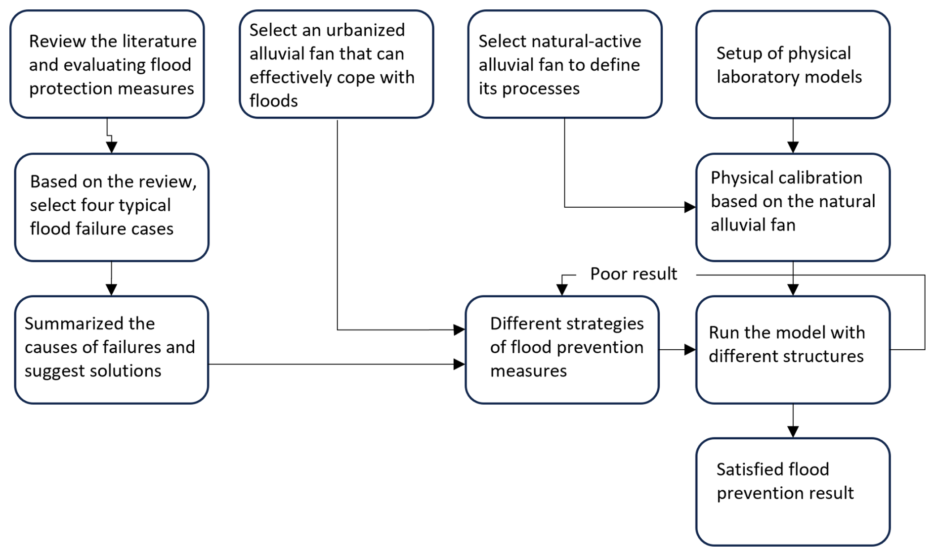
Table 1The examined alluvial fans – basic parameters. Locations of the investigated large floods are shown in italics.
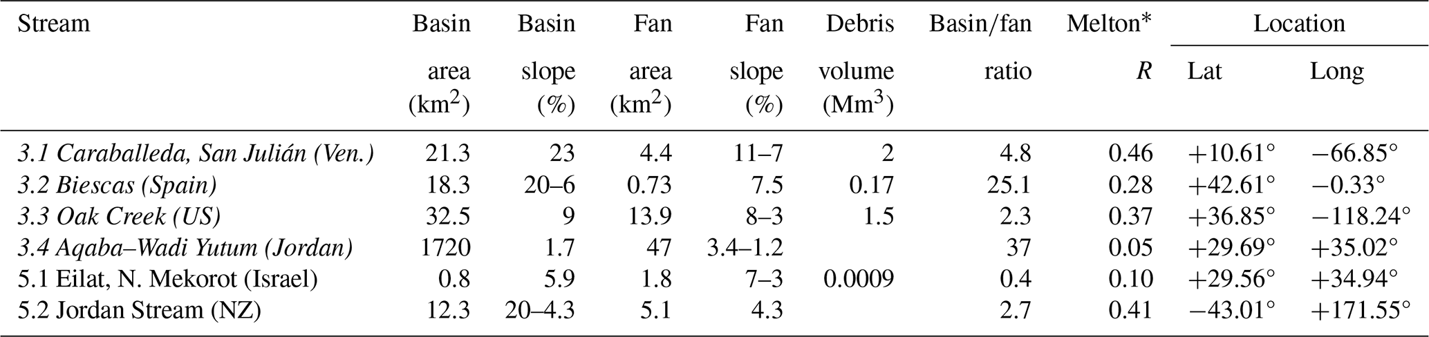
∗ Melton R likelihood of debris flows, 0.35–2.0 (typically > 0.7), and 0.07 < R < 0.7 is the range for fluvial flow processes (Melton, 1965).
The literature review (Step 1) was conducted to select case studies of large flooding in urbanized and natural alluvial fans. Case studies (Table 1) were selected based on four key criteria: (i) severity of the event; (ii) thorough documentation; (iii) availability of sufficient data for re-evaluation; and (iv) diversity of the cases in terms of causes, geographic locations, and contexts. A preliminary analysis has identified similarities in processes across geographic domains, particularly at the fan head and mid-fan, in relation to flood hazards.
For urbanized alluvial fans (Step 2), the reliability of flood control measures – comparing failure and non-failure cases – was analyzed to identify their limitations and the key factors contributing to degradation and collapse. This analysis focused on four case studies, including (i) the Caraballeda flood (Wieczorek et al., 2001; Larsen and Wieczorek, 2006; Salcedo, 2000; Lopez and Courtel, 2008), (ii) the Biescas flood (García-Ruiz et al., 1996; Benito et al., 1998; Alcoverro et al., 1999), (iii) the Oak Creek alluvial fan (Wagner et al., 2012; Google Earth images, July 2007–June 2009), and (iv) Wadi Yutum (Schick, 1971; Farhan and Anbar, 2014; Bany-Mustafa, 2016; Eom et al., 2011; Grodek, 2024; Google Earth images, December 2004). The cases analyzed helped to clarify the benefits of urban design in reducing the impact of flooding. In particular, the Eilat City Alluvial Fan Field Laboratory, established in 1966 (Table 1, Sect. 5.1), provided a continuously monitoring urban design, geomorphology, climate, and hydrology (e.g., Sharon, 1972; Schick and Lekach, 1993; Lekach and Enzel, 2021). The flood hazard of the city of Eilat is summarized by Grodek et al. (2000) and Grodek (2024).
To illustrate the degradation of sediment control measures over time (e.g., check dams), we present Fig. 10, comparing the design factor of safety (FS) with the actual FS as presented in the case study of Biescas, Pyrenees (discussed in Sect. 3.2): , where the stability force refers to the structure's strength (e.g., building materials and structural integrity), while the driving forces include factors such as structural degradation, aging, sedimentation pressure, water content, bank erosion, seepage, piping, and the severity of the expected events. An FS < 1 marks the point at which the structure is at risk of failure. Given the large number of parameters involved, physical calculations are complex and unreliable. Therefore, we demonstrate FS using the modified Gompertz–Makeham law of lifespan to model its progression over time: , where A represents the FS engineering design (1.5), B is a scaling constant for the age-dependent term (design: 0.0005 and actual: 0.03), and γ is the exponential structural degradation over time (design: 0.069 and actual: 0.05). For the sedimentation rate of a check dam, Vs(t), we assume a linear accumulation of sediments over time until the check dam reaches full capacity.
The spatial distribution of landforms and surface processes (Step 3), including debris flows, in-channel flows, and unconfined flows, were analyzed on an archetypal natural alluvial fan: Turkey Flat (Sect. 5.2; Table 1). This case study represents a pristine alluvial fan environment where surface processes and hydro-morphological parameters can be accurately quantified. Two distinct regimes exist within this natural fan, each characterized by different processes: the fan head and the main fan area. Within these morphological domains, the spatial distribution of landforms and surface processes – including sediment transport and deposition, fluvial processes, debris flows, in-channel flows, and unconfined flows – have been thoroughly examined (Sect. 5.2). This analysis provides important insights into the hydro-sedimentary dynamics that shape different sections of the fan and offers valuable guidance for developing nature-based solutions to support safer urbanization.
Finally, a laboratory analogue physical model was applied to test various types of flood prevention measures (Hooke, 1968; Schumm et al., 1987; Peakall et al., 1996; Davies et al., 2003; Clarke et al., 2010; Green, 2014). The setup consists of a feeding channel, a fan table, water supply, sand/gravel, and measuring devices (see Table 2 for their dimensions). Multiple tests were conducted to optimize the feeding canal for continuous sediment flow. The water flow rate was set at 0.4 L min−1 to cover 25 % of the fan area, increasing to 2.0 L min−1 for full coverage, corresponding to sediment concentrations of 25 %–30 % by weight (100–600 g min−1). The apparatus was first calibrated to replicate the fluvial processes of the Turkey Flat alluvial fan (Fig. 8; Sect. 5.2), including forms, dynamics, behavior, and geometries (similarity of processes). Subsequently, different control measures were tested for their functionality.

The operational setup of the device included placing a sediment storage of 320 g on the upper part of the feeding canal, with the water injected through the sediment storage pile and continuously maintained until a semi-circular “natural” alluvial fan with a radius of 0.5 m was symmetrically built up. The run shows continuous flow wandering and sedimentation across the fan area. Tests with mixed sand and gravel (Table 2) form levees composed of the gravel on the sides of the current active flow, which maintains the flow in the same path for a longer time before the abrupt change to a new flow path.
Active alluvial fans, both natural and urbanized, in different climatic regions show similarities in processes, allowing the study and comparison of different sites. Examples include (i) semi-arid regions, such as La Crescenta-Montrose and the Glendale flood in California (January 1934; Chawner, 1935) and the northern Wasatch Front from Salt Lake City to the north of Ogden, Utah (1983, Wieczorek et al., 1989; Lindskov, 1984); (ii) humid regions, such as the Alberta flood (Canada) (June 2013; Holm et al., 2016), the Biescas flood (Spain) (August 1996; Benito et al., 1998), the Caraballeda flood (Venezuela) (1999, Wieczorek et al., 2001), and the Longmen Mountains flood (China) (2008–2011, Chen et al., 2015); and (iii) arid regions, such as the Aqaba flood, Jordan (3 February 2006; Farhan and Anaba, 2016), and the southwestern United States (refer to FEMA, 1989, 2016). Below, we select examples of sites and discuss the conditions that trigger large floods, their impacts on natural and urban alluvial fans, and the valuable lessons learned from these events.
3.1 Caraballeda flood
In December 1999, the most devastating flood on alluvial fans occurred in Cordillera de la Costa (Vargas State, Venezuela; Table 1), leading to 15 000 deaths and estimated damage of USD 2 billion (Wieczorek et al., 2001; Larsen and Wieczorek, 2006). The steep San Julian River basin disgorged onto the city of Caraballeda, located on an alluvial fan. A single radial canal crossed the city. The 200 mm rainfall on 2–3 December, followed by 911 mm in 52 h on 14–16 December (Süveges and Davison, 2012), induced thousands of landslides and stream erosion along the Cordillera de la Costa basins, delivering abundant sediment to the basin floor. The following flood triggered an exceptional debris flow surge, blocked the cross-city canal, and affected 1.3 km2 of the town (Fig. 2b), with sediment volume estimated to be 2 Mm3 (total of ∼ 20 Mm3 along ∼ 40 km of the coast between La Guaira and Naiguatá). The basin ruggedness, R = 0.46, indicates the likelihood of both debris flows and fluvial processes. Historical records indicate one to two comparable events per century (Fig. 2a; 1798, 1912, 1914, 1938, 1944, 1948, and 1951; Salcedo, 2000; Lopez and Courtel, 2008); however, until the 1950s the area was mainly rural and less populated. The probability of the rainfall was calculated as T > 1000 years (pre-event) and T = 270 years thereafter, while the highest daily rainfall of 410 mm corresponded to T = 150 years (15 December 1999). Despite the exceptional magnitude of these events, between 2001 and 2008, 24 mountainous streams were channelized, and 63 dams were built in the canyons (37 are closed-type and 26 are open-type dams). Up to date, the dams have been subject to rapid sedimentation, and significant bed erosion has been observed downstream due to the clear water, which has entrained more sediment. In summary, ∼ 50 % of the 63 dams have lost their capacity, 7 have been destroyed, and 13 are suffering damage.
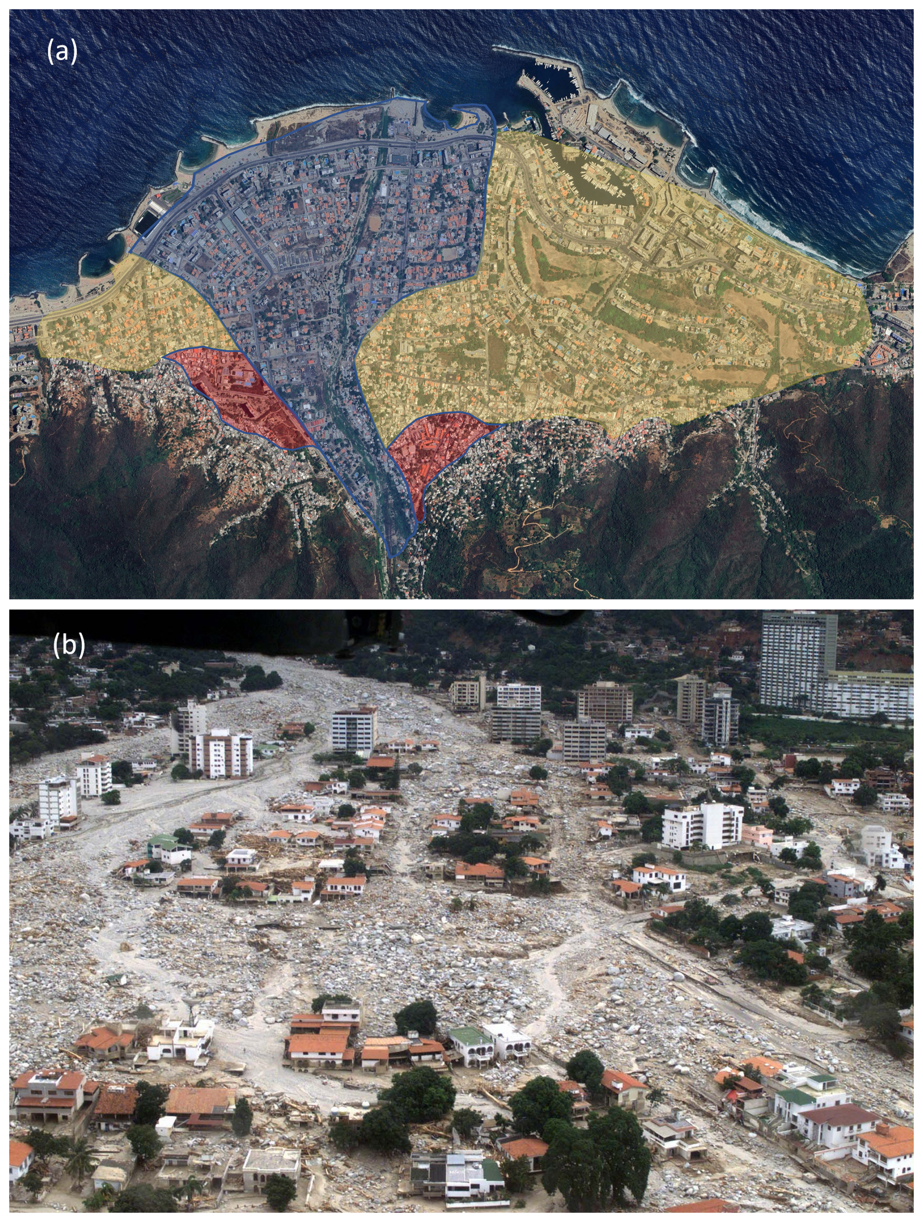
Figure 2The 1999 Caraballeda flood. The debris flow impacted 1.3 km2 of the city. (a) Flood deposits: blue, the 1999 flood; yellow, historic debris flow; and red, prehistoric deposits (source: Wieczorek et al., 2001). (b) Aftermath (source: Larsen and Wieczorek, 2006).
3.2 Biescas flood
The Biescas flood occurred in the Central Pyrenees (Aragón, Spain; Table 1) in August 1996 (causing 87 deaths). The alluvial fan of the Rio Barranco de Aras was prone to flooding. Between 1926 and 1943, 36 check dams were built in the steep basin (Fig. 3) to protect the road to France (N260–A136). In August 1996, > 200 mm of rain fell in 2 h, producing a flood peak of > 400 m3 s−1, breaching a sequence of 32 out of the 36 check dams and entraining 0.17 Mm3 of 0.20 Mm3 of suspended sediment (Fig. 4). The debris flow surge deposited at the fan head blocked the constructed mid-fan canal. The flow spread laterally, covering part of the fan, sweeping through a campsite and caravan park and dragging people and their caravans down to the Rio Gállego. The basin ruggedness, below the likelihood of debris flows (Melton R = 0.28), indicates that the collapsed check dams probably caused the debris flow surge (García-Ruiz et al., 1996; Benito et al., 1998). Historical records show two comparable events (1907, 1929).
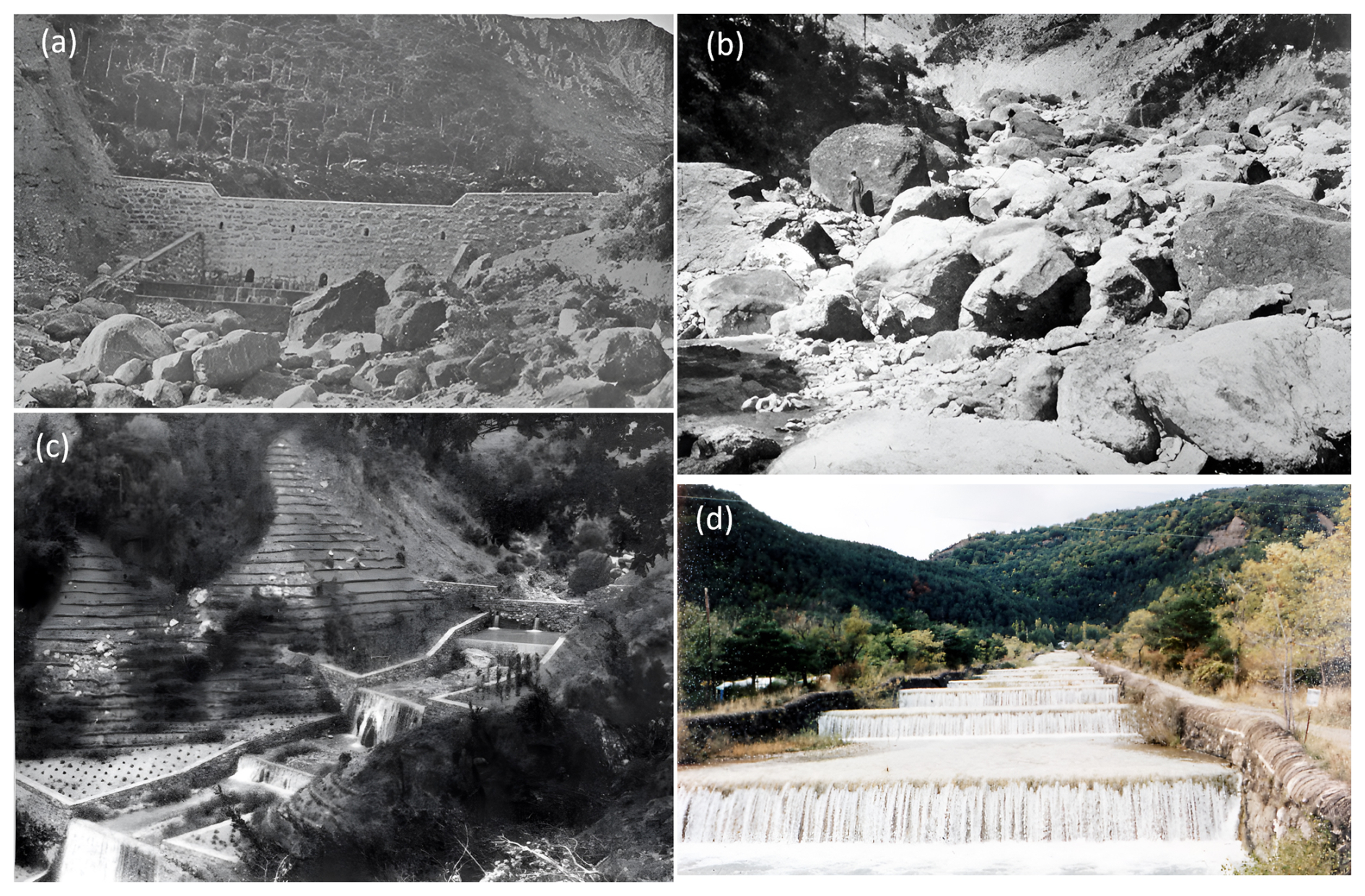
Figure 3Types of flood control measures widely used in European basins draining into urbanized alluvial fans. (a) Early check dams just after construction in 1907; (b) check dams after destruction in 1955; (c) check dams' revision and afforestation in 1963; and (d) the radial canal across the alluvial fan and the road, 3 years before the 1996 event. Source: https://www.inia.es/serviciosyrecursos/recursosdocumentales/forestales/fototecaforestal/Paginas/Imagenes.aspx?tema=*&provincia=HUESCA&municipio=BIESCAS#k=aras#l=3082 (last access: 17 September 2025).
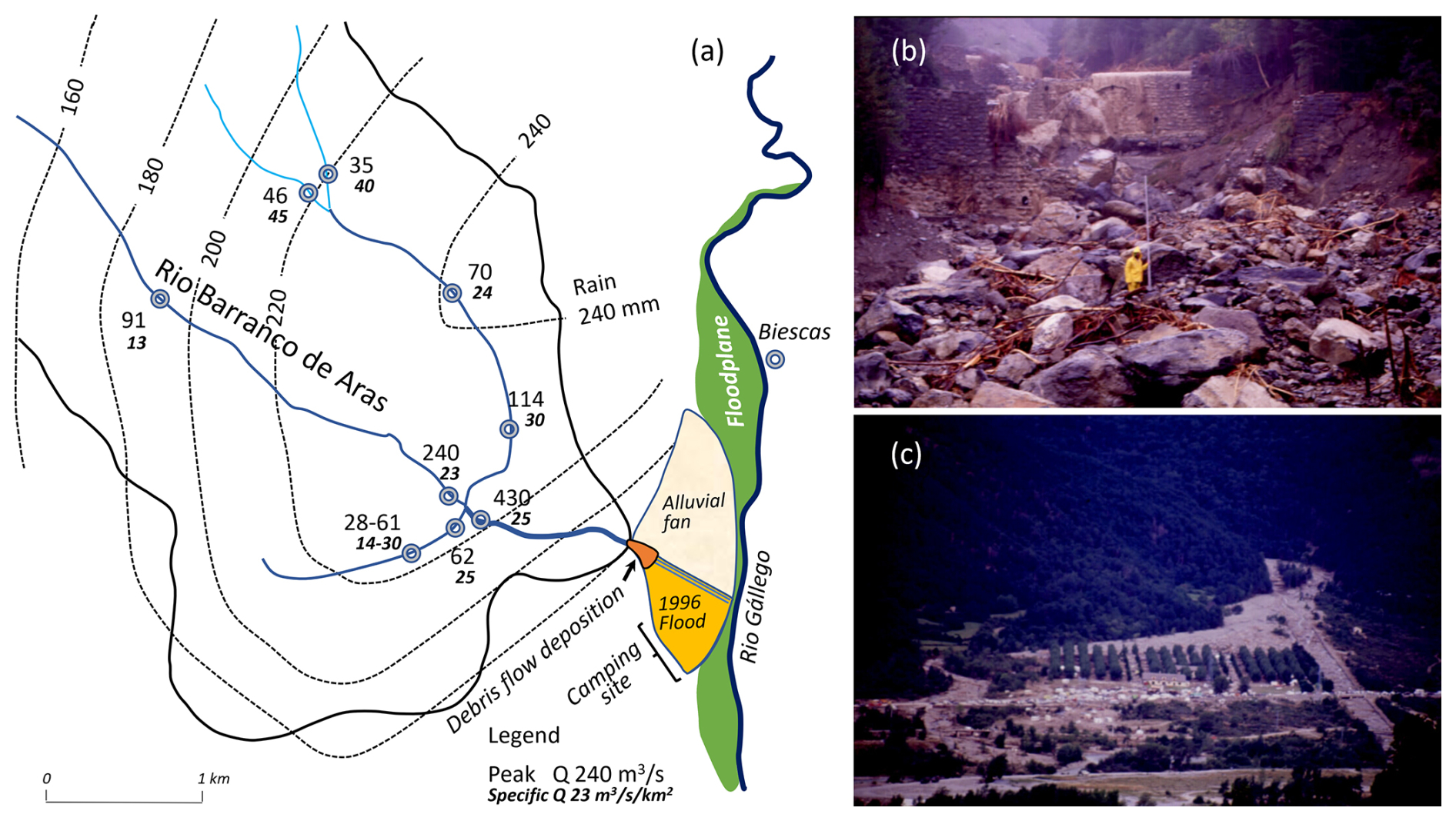
Figure 4Biescas flood, August 1996: (a) basin rainfall and flood discharges, (b) collapse of 32 check dams and remnants of the debris flow surge, and (c) the aftermath of the camping site. Source: Benito et al. (1998).
3.3 Mt. Whitney, Oak Creek alluvial fan
This flood occurred on 12 July 2008 in Nevada, USA (Table 1). Although this example is less disruptive, it is an illustration of the rule of rare events in arid regions that need to be considered. The alluvial fan of the Oak Creek River basin had not shown evidence of flooding for millennia. This is evidenced by the dark desert patina over the fan surface (Liu and Broecker, 2000) and the historic Mt. Whitney Fish Hatchery established on the riverbank in 1917, which has never been flooded (Fig. 5a). On 6 July 2007, a forest fire affected the basin, and 1 year later, on 12 July 2008, residual moisture from Hurricane Bertha caused high-intensity rainfall (97 mm h−1, 39 min). The following flood triggered 1.5 Mm3 of debris flows that spread over 7 km down the fan, damaging houses, including the fish hatchery (Fig. 5b). The debris flow surge (1–3 m in height) moved at estimated velocities of 2–5.4 m s−1 (DeGraff et al., 2011).
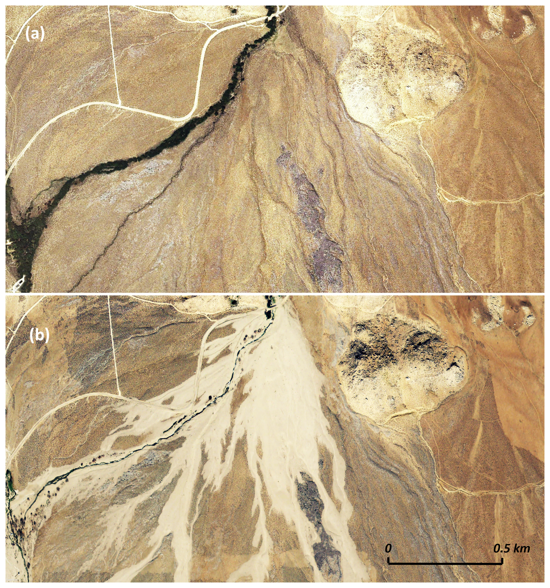
Figure 5Oak Creek alluvial fan. (a) Dark desert patina, indicating non-flooded surfaces for more than millennia (Liu and Broecker, 2000). (b) Following a forest fire, a heavy storm on the feeding basin triggered debris flows down to the alluvial fan, depositing 1.5 Mm3 of sediment. Note: white surfaces indicate the recent debris flows. Source: © Google Earth, July 2007 and June 2009.
3.4 Wadi Yutum alluvial fan
Situated on the shores of the Gulf of Eilat/Aqaba (Jordan, Table 1), the city covers a large part of the alluvial fan and is frequently inundated by desert flash floods disgorged from Wadi Yutum (Farhan and Anbar, 2014; Farhan and Anaba, 2016; Fig. 6). The basin covers ∼ 4000 km2 and drains mainly to depressions, and only 1720 km2 is hydrologically connected to the fan (e.g., Wadi Yutum El-Umran sub-basin, 770 km2). The flood of 3 February 2006 is an example of an arid flash flood. While only 1 mm of rain was measured over the cities of Eilat and Aqaba (avg. 25–40 mm yr−1), heavy rain, 5–10 km to the east (500–1200 ), covered a limited part of the basins (including W. Mubarak, s = 5.3 %; A = 65.1 km2). The flash flood (Qp = ∼ 550 m3 s−1) hit the city and further inundated the Eilat playa. The low Melton R of 0.05 indicates fluvial processes. A similar type of storm inundated the cities of Aqaba, Ma`an, and the Eilat playa on the night of 10–11 March 1966 (Schick, 1971). The flash flood of W. Mubarak destroyed the container port of Aqaba (located on a small alluvial fan, A = 0.4 km2). The discharge is unknown but is estimated to be 140–270 m3 s−1 (25–100 year flood probability, respectively).
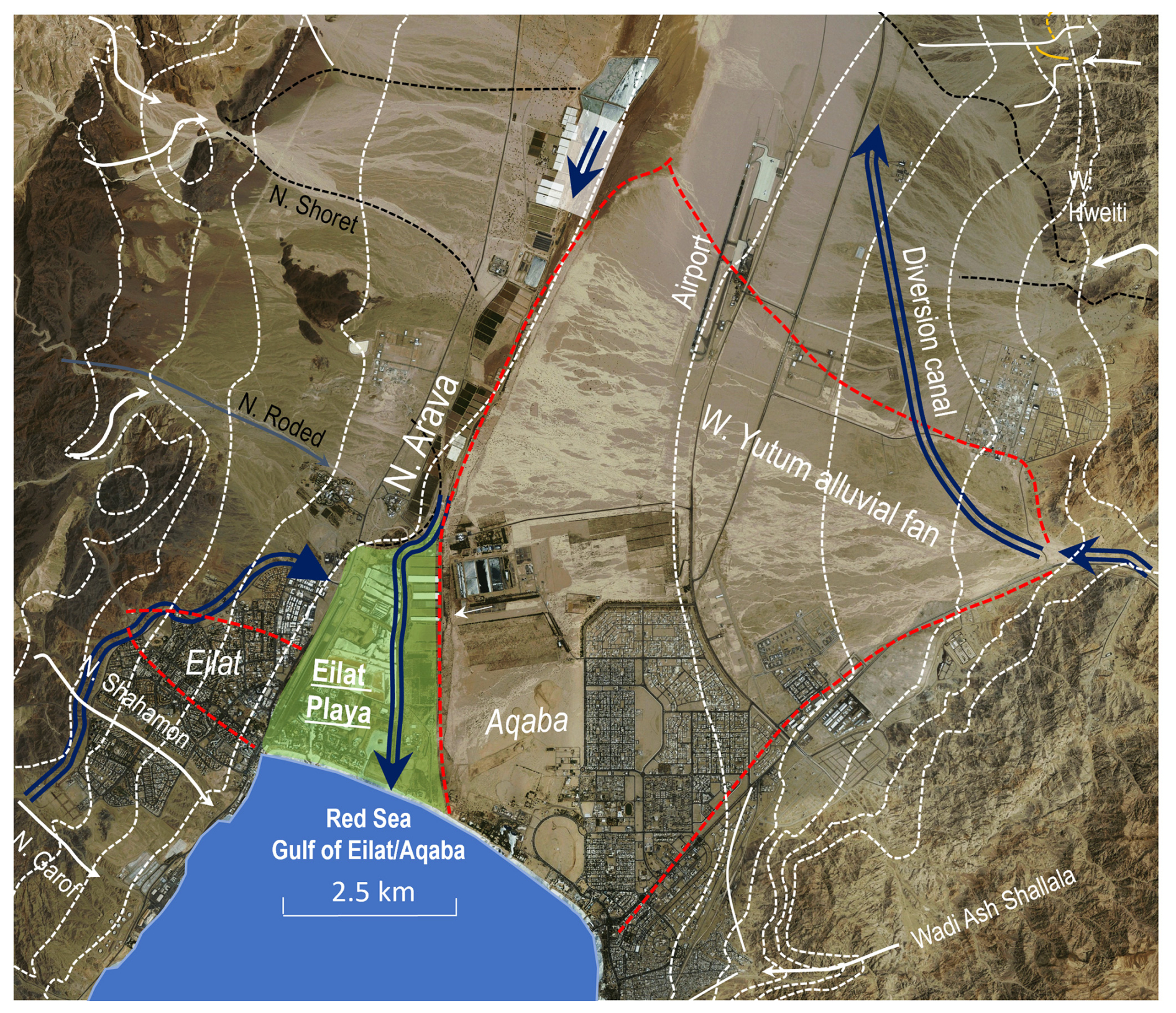
Figure 6Visible active distributary channels on the Wadi Yutum alluvial fan. Since the picture was taken (2004), the city has grown without leaving a short flow path to the sea; instead, several retention dams have been constructed to reduce sediment, and diversion canals have been built to bypass the city (Eom et al., 2011). The canal increases the flow path to the Red Sea from 8.5 to 27 km (slope drop from 2.4 % to 0.7 %, respectively), reducing the sediment-carrying capacity of floods. Source: © Google Earth 2004.
The Biescas disaster (Sect. 3.2) has similarities with many European urbanized alluvial fan prevention measures. Prior to 1925, frequent flooding and sediments breached the radial canal constructed along the alluvial fan, disrupting the transport route to France. To prevent sedimentation and breaching of the canal, 36 check dams were built along the steep Arás River (1925–1945). For 60 years these measures effectively prevented the canal from breaching, and a new campsite was built on the alluvial fan (1986). However, during this period, sediments gradually accumulated in the check dams, reducing their effectiveness and stability. A heavy rainstorm in 1996 triggered a flash flood, destroying 32 of the outdated dams in a domino effect and entraining 5 decades of retained sediments. The flow, in the form of a debris flow surge, destroyed the campsite and the road bridge. The basin's low likelihood of debris flow (Melton R = 0.28) indicated that the destructive debris surge was probably due to the collapse of the check dams (García-Ruiz et al., 1996; Benito et al., 1998). This event proves the escalation of risk over time, caused by flood control measures, as opposed to the risk along river valleys and floodplains, which generally does not escalate over time.
The forest fire on the Oak Creek Basin shows how flood prevention measures designed to stabilize steep slopes suddenly lose their functionality, becoming the dominant cause of destruction. We argue that, while for decades the forest has reduced runoff and prevented debris flows, snow avalanches, and rockfalls from reaching the alluvial fan, the sediment trapped by the forest has increased the risk of flooding. The most devastating alluvial fan flood, the Caraballeda disaster (Sect. 3.1), is an example of the limitations of engineering to protect urbanization from catastrophes and the limitations of relying on flood probabilities in the design of engineering control measures. The probability of rainfall, T > 1000 years (pre-event) and T = 270 years thereafter, indicates a decrease in reliability over time (Wieczorek et al., 2001; Larsen and Wieczorek, 2006).
Recovery efforts and disaster mapping have highlighted an interesting structural point: roads oriented radially down the fan, together with buildings oriented with their narrower faces toward the alluvial fan, proved to be the most effective in mitigating the effects of the debris flow surge. Downslope radial roads allowed overflow with minimal impact on buildings; conversely, buildings with longer faces oriented up the fan were most subject to collapse. These observations highlight the benefits of integrating flood prevention measures into urban design, a concept further explored in the study of the city of Eilat (Grodek et al., 2000; Sect. 5.1).
After the Caraballeda event, 35 prevention measures were built on the steep basins, complying with the 100-year flood standard (33 of which are gabions). However, 6 years later, 400 mm of rain triggered floods that filled 23 closed dams and half of the 13 open dams with sediment (Lopez and Courtel, 2008). Despite this, maintenance has not been carried out, and breaches of control measures are likely in the future (see the Biescas event, as noted above).
For 60 years, floods and sediments flowed freely through the city of Eilat, with only a circumferential road and gutter separating the bare, steep mountain slopes from the urbanized alluvial fan. Over the years, however, the city has experienced only minimal disruption to daily life. Monitoring of floods breaching the city and field experiments show that radial downslope four-lane roads extending from the fringe of the mountain front down to the fan toe cope best with flooding. This section examines the limitations and advantages of urban design (Sect. 5.1), compares this design with natural alluvial fan processes (Sect. 5.2), and tests the new protection strategy using physical laboratory models (Sect. 5.3). The results draw attention to the possibility of incorporating flooding into urban areas located on alluvial fans, as opposed to relying on the total prevention methods commonly used.
5.1 Flood monitoring over 60 years – physical settings
Intense tectonic processes at the margins of the Arava Rift valley have resulted in the formation of steep terrain and alluvial fans on both sides of the rift, where the cities of Eilat (Israel) and Aqaba (Jordan; see Sect. 3.4) are located. The cities extend from the mountain front (100–200 ) down to the playa and the sea. Bare terrain is evidence of extreme aridity (rainfall ranges of 25–45 mm yr−1 in the cities and 500–1200 in the mountains). The short-lived high-intensity rainstorms occasionally surprise the inhabitants with large floods. Long-term measurements reveal that 3 mm of rainfall is the threshold for slope runoff, and > 6 mm of rainfall triggers flooding from the steep and small basins that propagate down to the margin. Eilat (Israel, pop. 50 000) is partly built on an active alluvial fan, surrounded by 20 basins draining into the city without a buffer (each 0.05–0.8 km2, totaling 2.3 km2). The largest basin discharges into the urbanized alluvial fan (1.8 km2) with a sediment concentration of up to 20 % (60 %–90 % is bedload > 16 mm; 10 %–40 % is suspended sediment, depending on the type of the individual flood).
The urban framework is crisscrossed by road networks (30 % of the urban area, including car parks; Fig. 7a). The four-lane radial roads, which follow the fan slope (3 %–7 %), efficiently transport floodwaters down to the playa. The orthogonal roads, parallel to the fan contours (slopes 0 %–0.5 %), are often inundated during floods or urban runoff.
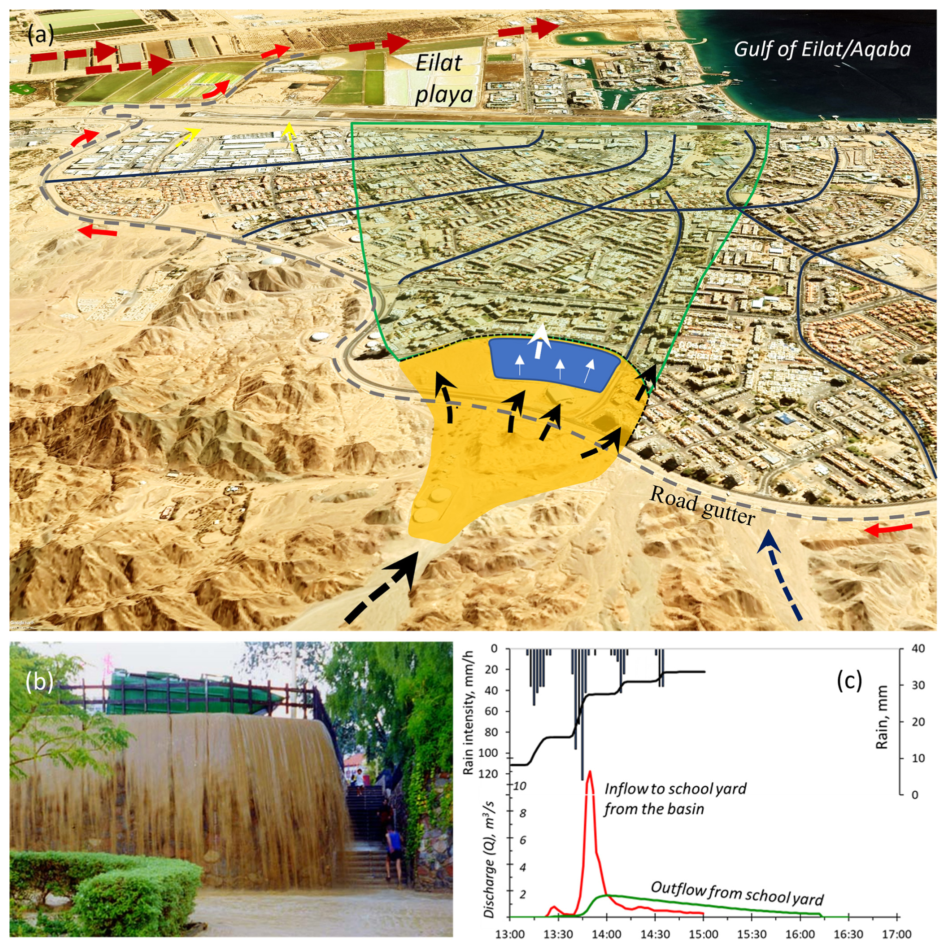
Figure 7Eilat, 1997 flood. (a) Flood disgorged from the canyon to the fan head (orange cone), depositing sediment and blocking the circumferential canal. By flooding the school compound (blue), the flow attenuated and spread between several four-lane roads (black arrows) without overtopping. Thus, the damage was minimal (b). (c) Rainfall and the attenuation of flood discharge through the city (calibrated based on Nahal Yael hydrometric stations). Source (a): © Google Earth 2024.
The largest flood (October 1997) was followed by 16 years of drought. During this period, the city had largely expanded without any attention to drainage or flood prevention measures. Two sub-storms hit the city. The first, 16 mm, mainly covered the city (5 km2), and the urban runoff was lower than expected (12.5 %, 10 000 m3), resulting in urban areas being disconnected from the malfunctioning urban drainage system and therefore locally inundated (e.g., parking lots, dwellings, playgrounds). The second sub-storm, 25–40 mm (intensities > 70 mm h−1), mainly covered the bare granite slopes surrounding the town. The flash flood from the largest basin was 11 m3 s−1, and flow volumes were estimated at 6000 m3 (21 % runoff). The discharged sediment, 850 m3, blocked the circumferential road gutter (70 m3) and inundated the school grounds located at the fan head. The gated school, including a soccer field, acted as a retention pond, and the flow was attenuated over 0.25 km from an incoming peak discharge of 11 to 1.6 m3 s−1 at the school gate, depositing most of the sediment (Fig. 7b and c). Further downstream, the flow was divided by a complex four-lane road network, and the peak discharge was further reduced to ∼ 0.4 m3 s−1 per road, with limited overflow. Following these decades of experience with urban flooding, this flood prevention method was further investigated as an alternative to the total flood protection (Grodek et al., 2000; Grodek, 2024).
5.2 Natural processes
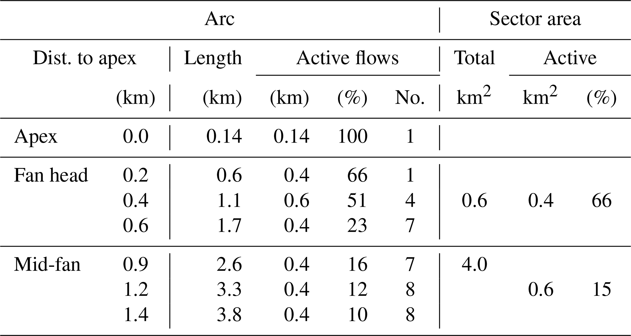
The street pattern of the city of Eilat shows similarities to the natural channel structure and processes, as demonstrated in the Jordan Stream (feeding basin) and Turkey Flat (alluvial fan). This semi-circular, almost perfect “classic” alluvial fan is still natural and, in theory, large enough for future development (Fig. 8, Table 1). The steep river basin consists of periglacial colluvial deposits overlying bedrock and fractured Triassic sandstone/siltstone. High rainfall (1450–1600 mm yr−1) and relatively frequent earthquakes cause basin instability and landslides, with floods transporting large amounts of sediment to the alluvial fan. The floods are frequent enough to cover most of the fan area in about a decade. This allows only fast-growing matagouri plants to grow between floods. The maximum measured regional flood peaks (Pearson and Henderson, 2004) suggest 250 m3 s−1 for similar basins, while the calculated 100-year flood probability is 53 m3 s−1 (Griffiths et al., 2011). The flow pattern on the alluvial fan shows two distinct zones (Table 2): (i) the transition from the narrow and steep canyon (width = 0.14 km) to the open valley (width = 1.7 km) creates a zone (fan head sector) of high activity of flooding and sediment deposition, with violent changes in flow direction (area = 0.6 km2, 66 % active). Its activity is indicated by sediment abrasion and lack of vegetation (Fig. 8a). Severe storms cover the entire fan head. (ii) Below, the mid-fan (area = 4 km2, 15 % active) is characterized by seven to nine distinct individual shallow channels distributed radially from the fan head to the fan toe. Each channel has an average width of 50 m (total width: 400 m). The density and the size of the vegetation indicate the relative time interval between out-of-channel floods (Fig. 8a).
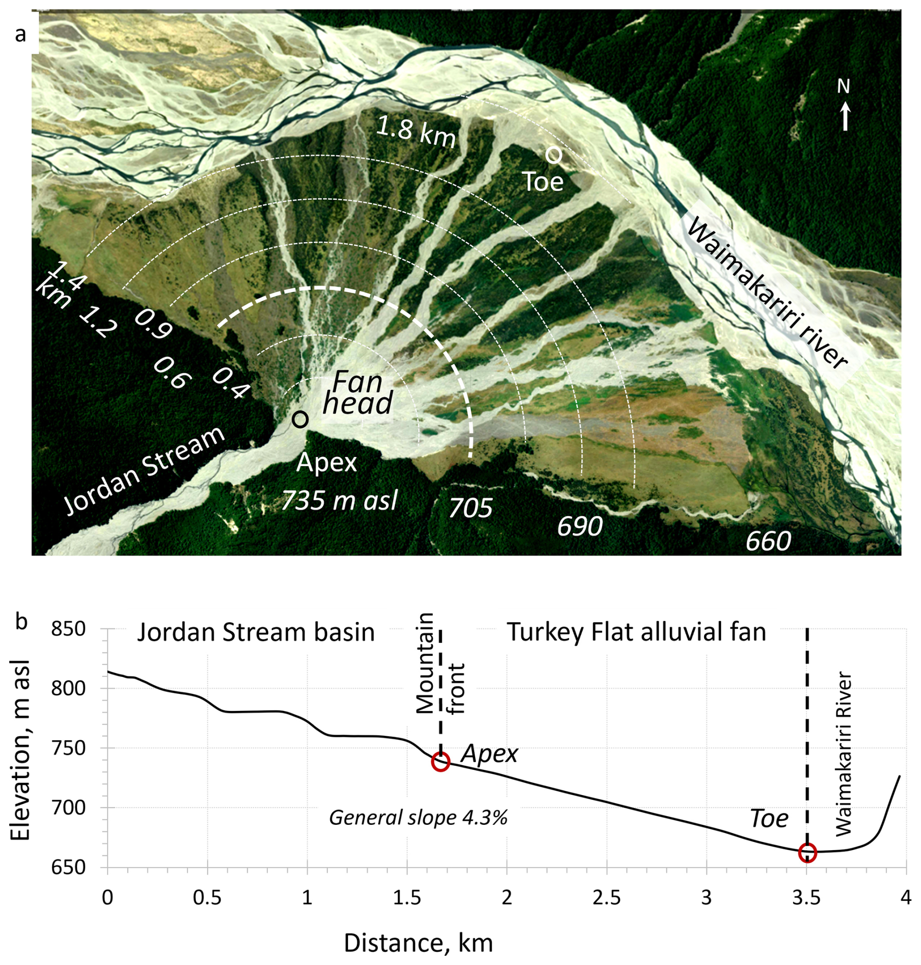
Figure 8(a) Turkey Flat alluvial fan. Color ranges indicate relative time laps between floods: white – recent activity; grey – recently abandoned, partly weathered sediments and seasonal vegetation (< 3 years); yellow – annual plants and the beginning of shrub germination (> 3 < 10 years); and green – mature bushes of the matagouri plant, long periods without flooding (> 10 years). Dashed lines: the semi-circle arcs for measuring active channels (Table 3), (b) longitudinal profile from the mountain river down to the fan toe and across the Waimakariri River. Image: https://mapviewer.canterburymaps.govt.nz/ (last access: 17 September 2025).
These important observations show that as the flow progresses down the alluvial fan, a progressively larger area remains unaffected by the flood (Table 3; Fig. 8). In general, the proportions of affected and unaffected areas are related to the flood magnitude and the ratio (Table 1); the higher the ratio, the larger the active areas. The example of the Turkey Flat alluvial fan shows that while 66 % of the area at the fan head is subject to flooding during a single event, only 15 % of the area at the mid-fan is affected, meaning that 85 % of the mid-fan can be considered for safer zone design.
Table 3Flooded areas on the fan head and the main fan areas (see arcs in Fig. 8).
5.3 The laboratory analogue physical model
The first step in applying the analogue physical model was to set up the apparatus to achieve process similarity with the Turkey Flat alluvial fan (Fig. 9a and b; see Sect. 5.2). The model was examined under fluvial conditions. The model setup is described in detail in Sect. 2.
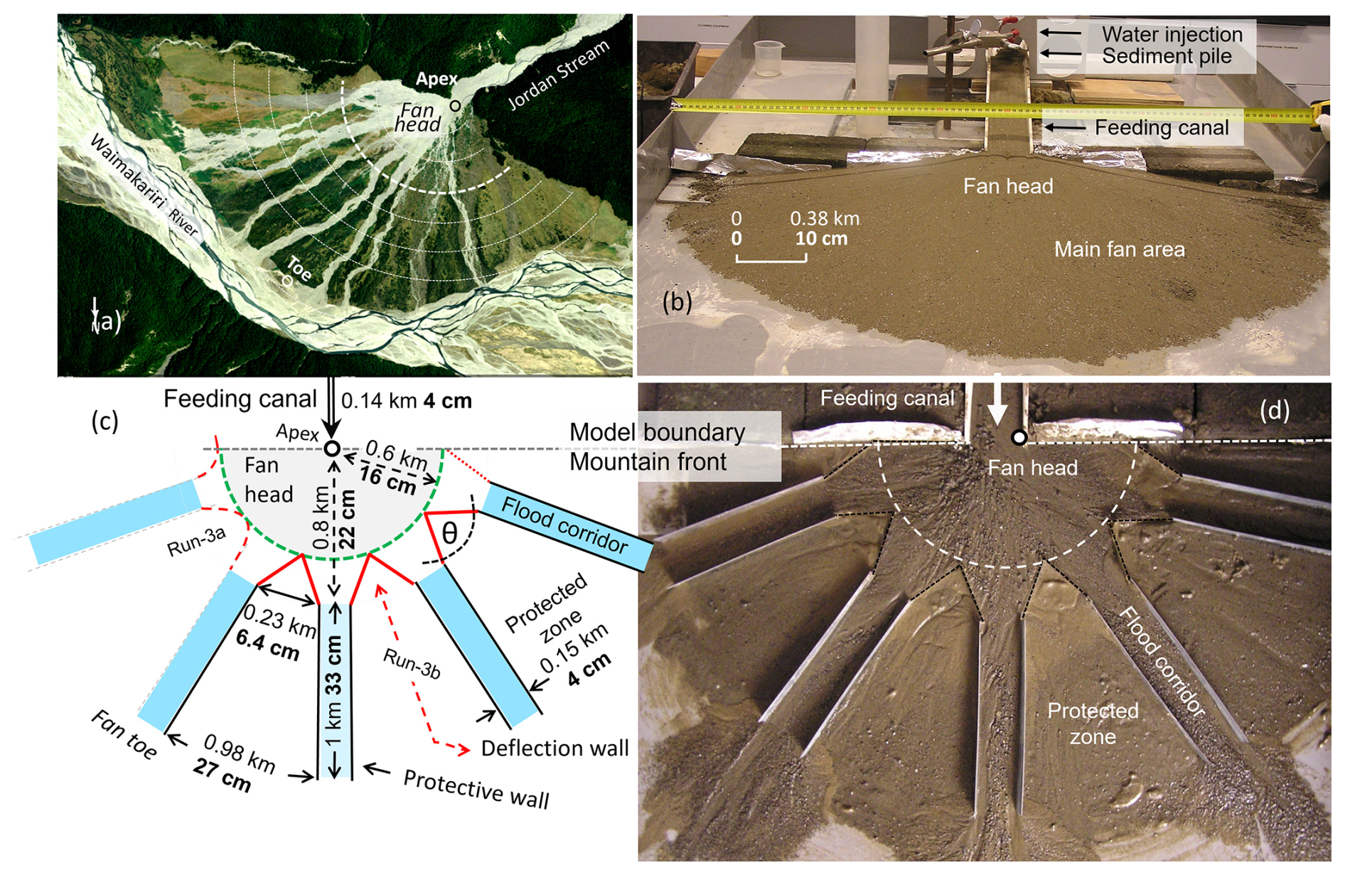
Figure 9(a) Turkey Flat alluvial fan. (b) Physical model setup (see Sect. 2). (c) Sketch of the final model simulation, Run 3b (Run 3a in dashed). Dimensions: (i) normal letters, the proposed design; (ii) letters in bold, the laboratory physical model. Angle of θ < 45°. (d) View of the final physical model simulation (mixed sediment sizes; for the model parameters, see Table 2). Figure 9a: https://mapviewer.canterburymaps.govt.nz/ (last access: 17 September 2025).
Once the calibration was established, control measures were introduced to the alluvial fan. A first attempt was made to test the feasibility of applying radial control canals from the fan apex and the fan head sector. These included (i) parallel canals down to the toe of the fan (Runs 2a–b) and (ii) semi-circular alternating walls and gates, which divert flows to pre-defined corridors along the steepest slope (Run 2b). Both attempts failed to properly distribute sediment down the alluvial fan, resulting in immediate sedimentation and breaching of the floodwaters carrying sediment into the pre-defined safe zone. This consistent failure to control the flow at the fan head sector leads to the conclusion that this area should be preserved to allow natural processes to continue. Further attempts focus on the alluvial fan only, dividing the main fan area between alternating urbanization protection zones and flood corridors, replicating the natural flow observed on the Turkey Flat alluvial fan. The first attempt with a semi-circular deflector wall structure was disappointing as sediment accumulated in front of the structure and was frequently evacuated, threatening the protected zone (Run 3a; Fig. 9c). The attempt with arrow-shaped deflector walls (θ < 45°) showed the best result of continuous evacuation of floods and sediments out of the alluvial fan (Run 3b; Hollingsworth and Kovacs, 1981). θ higher than 45° causes sedimentation above the deflector wall. This result was confirmed using both sorted sand and mixed sand and gravel (Fig. 9c and d).
Protecting urban areas on active alluvial fans from flooding is a challenge that requires a comprehensive understanding of natural processes and the limitations of control measures. The engineering strategy includes the construction of canals and embankments on the alluvial fan to divert incoming floodwaters and the construction of sediment retention structures on the steep feed basins to protect these canals and levees from sedimentation and breaching. Initially, these control measures adequately protect urbanization and encourage greater occupation on alluvial fans. However, this leaves limited areas for future flood control improvements and leaves more assets vulnerable to flooding.
Despite sediment control measures, natural and humanmade processes continue on the steep mountain feeding basins. These processes include weathering, erosion, debris flows, snow avalanches, rockfalls, forest fires, earthquakes, and human activities (such as service roads, plantations, mining, and maintenance; Amaranthus et al., 1985). Consequently, sediments gradually accumulate in the check dams and terraces, increasing pressure and eventually leading to collapse, sending decades of accumulated sediments into urban areas (Sodnik et al., 2015). The growing volume of literature on failures and damage underscores the ongoing challenges and unresolved nature of this issue.
The long-term benefits of afforestation in stabilizing steep slopes and retaining hazards are also being questioned. While forested areas reduce runoff and increase soil water content through biomechanical and biochemical weathering by roots, these processes can reduce the strength of fractured bedrock and soil. Heavy rainfall can increase the build-up of porewater pressure, leading to slope instability and landslides (Marden and Rowan, 2015). In addition, prolonged droughts resulting from climate change may trigger more frequent wildfires. These fires expose burned soil to rainfall, which increases runoff and transports dead trees and decades of weathered and trapped sediment to the alluvial fan (see Sect. 3.3; DeGraff et al., 2011; Resco de Dios et al., 2021).
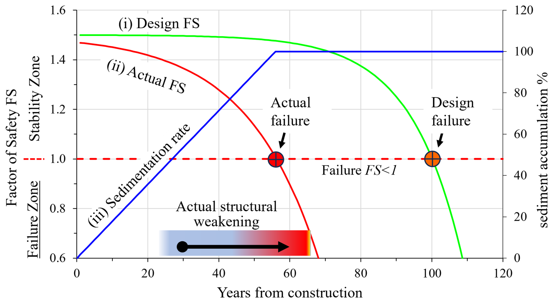
Figure 10Functionality of flood prevention measures in time as a factor of safety (FS): (i) engineering design (generally FS = 1.5); (ii) actual FS in time as a result of sedimentation, water pressure, and structural erosion and aging; and (iii) sediment accumulation in the check dam, Vs (%). It should be noted that the designed safety factor for a 100-year service life is reduced to less than 60 years as a result of structural degradation (e.g., progressive deterioration of materials due to temperature and/or water changes and occurrence of extreme impacts).
The design of sediment control measures is typically based on the 100-year rainfall probability (design FS, Fig. 10i) and assumes a homogeneous event distribution. However, recent trends in climate change, characterized by record-breaking storms, raise concerns about the reliability of current recurrence interval practices. Examples include Caraballeda, Venezuela, with 900 mm of rainfall in 52 h; Biescas, Spain, with 250 mm in 2 h (Sect. 3.1–3.2); and Val Canale, Italy, with 285 mm in 4 h (390 mm total, Tropeano and Turconi, 2004). These catastrophic events raise questions about the reliability of predicting the next disaster (Davies and McSaveney, 2011) and suggest that flood control measures have often been implemented without adequate assessment for maintenance or prediction of the potential damage from their failure (Fig. 10).
The limitations mentioned above, along with the Caraballeda flood (which resulted in 15 000 deaths, 2 Mm3 of debris flows, and ∼ USD 2 billion in losses, Wieczorek et al., 2001), force us to acknowledge our limitations in controlling natural processes with conventional engineering practices (summary edited by Jakob et al., 2024).
The Ecosystem-based Disaster Risk Reduction (Eco-DRR) initiative encourages research into how natural alluvial fan processes can be used to improve safety. The continuous evacuation of sediments from steep mountain basins results in a sudden drop in energy flow on the fan apex. This causes sedimentation and chaotic changes in flow direction. However, while this chaotic process occurs at the fan head, downslope in the main fan sector, the flow splits, forming multiple parallel radial flow paths, each carrying only a fraction of the incoming flow. These shallow, radial flow paths with limited sediment transport are far more manageable. Therefore, this flow characteristic is the focus of our proposed solution.
Observations from the city of Eilat along with post-flood surveys in the cities of Caraballeda (Sects. 5.1 and 3.1, respectively) suggest an effective urban structure for building on alluvial fans: (i) preserve natural processes in the mountain feeding basins to allow uninterrupted sediment evacuation; (ii) keep the fan head in a natural state (20 % of the fan area) to absorb the impact of the flood disgorging from the steep mountain basin, thereby reducing the destructive force of both water and sediments; (iii) divide the main body of the alluvial fan into sectors with (a) longitudinal flood corridors (15 % of the fan area) and (b) safe urban zones (65 % of the fan area, Fig. 9c and d); and (iv) design urban structures (dwellings, roads, parking lots, recreation areas, and sports fields) to withstand severe flooding in the case of urbanization breaching, with reduced damage and disruption to city life.
In the city of Eilat, a practical design uses the outdoor recreation area at the fan head to help manage flash floods. When a flood occurs, the fan head slows down the water, lets sediments settle, and splits the flow into several wide four-lane roads that follow the fan slope. Each road carries only part of the flood, reducing the overall risk (Fig. 7). These roads can also be designed as low-lying recreation areas when it is dry.
In rare, extreme rainstorms where flood corridors overflow, both Eilat and Caraballeda show how building and road orientation can help reduce damage. In Caraballeda, buildings oriented with their narrower side facing up the fan and wide radial roads downslope significantly minimized the impact and destruction caused by floodwater and debris (Wieczorek et al., 2001; Larsen and Wieczorek, 2006; Pennington, 2009).
Using a physical analogue model apparatus (Hooke, 1968; Clarke et al., 2010; Clarke, 2015) shows that natural processes can be effectively replicated. This helps with designing structural elements and provides robust results.
In summary, our investigation suggests that a minor shift in the spatial arrangement of urban design priorities can lead to long-term disaster risk reduction on an urbanized alluvial fan.
Flood control measures in steep mountain basins have historically been effective in reducing sediment transport to urban areas situated on alluvial fans, providing a high degree of safety for decades. However, ongoing natural weathering and erosion processes result in the gradual accumulation of sediment within terraces, check dams, and forested slopes. Without maintenance, the effectiveness of these control measures gradually diminishes over time. As their stability weakens, intense rainstorms can trigger slope instability, potentially causing a catastrophic collapse of the entire aging control system, resulting in destructive debris flows that surpass the force of natural floods.
To address this issue, we have studied natural processes on alluvial fans and propose a paradigm shift: leave steep mountain basins untouched while integrating flood control measures within urban areas by preserving 20 %–30 % of the alluvial fan area for natural flood and sediment transport. This approach preserves the fan head in its natural state (or recreation area), allowing sediment delivery by floods from the steep, narrow mountain front to occur naturally, thereby reducing its destructive force. Below the fan head, the main alluvial fan area is managed by diverting the flow through several equally distributed radial flood corridors down to the fan toe. By splitting the flow, each corridor carries a fraction of the incoming flood, resulting in less dangerous and more manageable floods. Continuous evacuation of sediment from the basin prevents accumulation and potential collapse.
This model of flood prevention is exemplified by the city of Eilat, where urban design, including a large football playground at the fan head and a wide radial longitudinal road to the fan toe, has successfully mitigated flood impacts with minimal disturbances to city life. A post-flood survey in Caraballeda further highlights the importance of coupling building orientation, with its narrow face upslope, with radial roads to reduce the impact of catastrophic flooding and to channelize destructive floodwaters and debris flows. The feasibility of this paradigm was tested and verified using a physical analogue model in the laboratory, confirming its potential for effective flood management.
Aerial photographs, both recent and historical, were obtained from several sources: Figs. 5–7, © Google Earth and Figs. 8a and 9a, the Environmental Canterbury Regional Council (Aotearoa / New Zealand, https://mapviewer.canterburymaps.govt.nz/, last access: 17 September 2025). Historical photographs in Fig. 3 were obtained from the National Institute of Agricultural and Food Research and Technology (INIA-Spain, https://www.inia.es/serviciosyrecursos/recursosdocumentales/forestales/fototecaforestal/Paginas/Imagenes.aspx?tema=*&provincia=HUESCA&municipio=BIESCAS#k=aras#l=3082, last access: 17 September 2025).
TG and GB conceived the ideas and jointly prepared the paper design. TG conducted the physical experiments and created graphics.
The contact author has declared that neither of the authors has any competing interests.
Publisher's note: Copernicus Publications remains neutral with regard to jurisdictional claims made in the text, published maps, institutional affiliations, or any other geographical representation in this paper. While Copernicus Publications makes every effort to include appropriate place names, the final responsibility lies with the authors.
The contribution from the Hydrology and Climate Change Laboratory (@floods_research on X and Instagram) is acknowledged. The authors thank Tim Davies (University of Canterbury) and the reviewers for their valuable input.
This paper was edited by Animesh Gain and reviewed by Mohammed Sarfaraz Gani Adnan and Mirela-Adriana Anghelache.
Alcoverro, J., Corominas J., and Gómez, M.: The Barranco de Arás flood of 7 August 1996 (Biescas, Central Pyrenees, Spain), Eng. Geol., 51, 237–255, https://doi.org/10.1016/S0013-7952(98)00076-3, 1999.
Amaranthus, M. P., Rice, R. M., Barr, N. R., and Ziemer, R. R.: Logging and Forest Roads Related to Increased Debris Slides in Southwestern Oregon, J. Forest., 83, 229–233, https://doi.org/10.1093/jof/83.4.229, 1985.
Baggio, T. and D'Agostino, V.: Simulating the effect of check dam collapse in a debris-flow channel, Sci. Total Environ., 816, 1–12, https://doi.org/10.1016/j.scitotenv.2021.151660, 2022.
Ballesteros-Cánovas, J. A., Stoffel, M., Corona, C., Schraml, K., Gobiet, A., Tani, S., Sinabell, F., Fuchs, S., and Kaitna, R.: Debris-flow risk analysis in a managed torrent based on a stochastic life-cycle performance, Sci. Total Environ., 557–558, 142–153, https://doi.org/10.1016/j.scitotenv.2016.03.036, 2016.
Bany-Mustafa, M.: Flash flood hazard and risk maps for Wadi Yutum, The Second International Symposium on Flash Floods in Wadi Systems, ISFF 25–27 October 2016, Technische Universität Berlin, Campus El Gouna, Egypt, http://hdl.handle.net/2433/228066 (last access: 17 September 2025), 2016.
Benito, G., Grodek, T., and Enzel, Y.: The geomorphic and hydrologic impacts of the catastrophic failure of flood-control-dams during the 1996-Biescas flood (Central Pyrenees, Spain), Z. Geomorphol., 42, 417–437, 1998.
Blackwelder, E.: Fire as an Agent in Rock Weathering, J. Geol., 35, 134–140, 1927.
Bull, W. B.: The alluvial-fan environment, Prog. Phys. Geog., 1, 222–270, https://doi.org/10.1177/030913337700100202, 1977.
Chawner, W. D.: Alluvial Fan Flooding: The Montrose, California, Flood of 1934, Geogr. Rev., 25, 255–263, 1935.
Chen, X., Cui, P., You, Y., Chen, J., and Li, D.: Engineering measures for debris flow hazard mitigation in the Wenchuan earthquake area, Eng. Geol., 194, 73–85, https://doi.org/10.1016/j.enggeo.2014.10.002, 2015.
Clarke, L.: Experimental alluvial fans: Advances in understanding of fan dynamics and processes, Geomorphology, 244, 135–145, https://doi.org/10.1016/j.geomorph.2015.04.013, 2015.
Clarke, L., Quine, T. A., and Nicholas, A.: An experimental investigation of autogenic behaviour during alluvial fan evolution, Geomorphology, 115, 278–285, 2010.
Cools, J., Mishara, A., and Verbist, K.: Best practices on flood and drought risk management, UNESCO, https://unesdoc.unesco.org/ark:/48223/pf0000384487 (last access: 17 September 2025), 2023.
Davies, T. R. and McSaveney, M. J.: Principles of sustainable development on fans, J. Hydrol. (NZ), 47, 43–65, 2008.
Davies, T. R. and McSaveney, M. J.: Bedload sediment flux and flood risk management in New Zealand, J. Hydrol. (NZ), 50, 181–190, 2011.
Davies, T. R. H., McSaveney, M. J., and Clarkson, P. J.: Anthropic aggradation of the Waiho River, Westland, New Zealand: microscale modelling, Earth Surf. Proc. Land., 28, 209–218, 2003.
DeGraff, J. V., Wagner, D. L., Gallegos, A. J., DeRose, M., Shannon, C., and Ellsworth, T.: The remarkable occurrence of large rainfall-induced debris flows at two different locations on July 12, 2008, Southern Sierra Nevada, CA, USA, Landslides, 8, 343–353, https://doi.org/10.1007/s10346-010-0245-5, 2011.
Dell'Agnese, A., Mazzorana, B., Comiti, F., Von Maravic, P., and D'agostino, V.: Assessing the physical vulnerability of check dams through an empirical damage index, J. Agr. Eng., 44, 9–16, 2013.
Di Baldassarre, G., Kreibich, H., Vorogushyn, S., Aerts, J., Arnbjerg-Nielsen, K., Barendrecht, M., Bates, P., Borga, M., Botzen, W., Bubeck, P., De Marchi, B., Llasat, C., Mazzoleni, M., Molinari, D., Mondino, E., Mård, J., Petrucci, O., Scolobig, A., Viglione, A., and Ward, P. J.: Hess Opinions: An interdisciplinary research agenda to explore the unintended consequences of structural flood protection, Hydrol. Earth Syst. Sci., 22, 5629–5637, https://doi.org/10.5194/hess-22-5629-2018, 2018.
Ding, M., Lin, P., Gao, S., Wang, J., Zeng, Z., Zheng, K., Zhou, X., Yamazaki, D., Gao, Y., and Liu, Y.: Reversal of the levee effect towards sustainable floodplain management, Nat. Sustain., 6, 1578–1586, https://doi.org/10.1038/s41893-023-01202-9, 2023.
Dutton, C. E.: Report on the geology of the high plateaus of Utah, USGS, Rocky Mountain region, Washington, 307 pp., 1880.
Eom, M., Murphy, B., and Stahr, L.: Sediment Transport and Scour Analysis for Wadis in Aqaba, Jordan, World Environmental and Water Resources Congress 2011, ASCE Conference, Palm Springs, California, USA, https://doi.org/10.1061/41173(414)216, 2011.
Fabregas, S., Hurtado, R., and Mintegui J.: The protection of Canfranc Internation Railway Station against natural risks. Analysis and evaluation of its effectiveness 100 years later, EGU General Assembly, Vienna, Austria, 22–27 April 2012, EGU2012-2306-1, 2012.
Farhan, Y. and Anbar, A.: Fragile Landscape: Impact and Consequences of May 2014 Flash-flood Disaster in the Aqaba Area, Southern Jordan, Research Journal of Environmental and Earth Sciences, 6, 451–465, https://doi.org/10.19026/rjees.6.5257, 2014.
Farhan, Y. and Anaba, O.: Flash Flood Risk Estimation of Wadi Yutum (Southern Jordan) Watershed Using GIS Based Morphometric Analysis and Remote Sensing Techniques, Open Journal of Modern Hydrology, 6, 79–100, https://doi.org/10.4236/ojmh.2016.62008, 2016.
FEMA – Federal Emergency Management Agency: Alluvial Fans: Hazards and Management, Report No. FEMA-165, 17 p., Federal Insurance Administration, Office of Loss Reduction, 1989.
FEMA: Guidance for Flood Risk Analysis and Mapping – Alluvial Fans, Guidance Document 75, 31 pp., FEMA (Federal Emergency Management Agency), technical guidance series, https://www.fema.gov/sites/default/files/2020-02/Alluvial_Fans_Guidance_Nov_2016.pdf (last access: 17 September 2025), 2016.
Flez, C. and Lahousse, P.: Recent Evolution of Natural Hazard Management Policy in France, the Example of Serre-Chevalier (French Alps), Environ. Manage., 34, 353–362, https://doi.org/10.1007/s00267-004-2777-8, 2004.
French, R. H.: Hydraulic Processes on Alluvial Fans, Elsevier, 244 pp., ISBN: 978-0-444-42781-6, 1987.
French, R. H.: Preferred directions of flow on alluvial fans, J. Hydraul. Eng., 118, 1002–1322, 1992.
Fuller J. E. and Meyer, D. P.: Case Studies of Flood Impacts to Development on Active Alluvial Fans in Central Arizona, Arizona Geological Survey Contributed Report CR-18-J, 107 p., http://hdl.handle.net/10150/630261 (last access: 17 September 2025), 2018.
García-Ruiz, J. M., White, S. M., Martí-Bono, C., Valero, B., Errea, M. P., and Gómez-Villar, A.: La Catástrofe del Barranco de Arás (Biescas, Pirineo Aragonés) y su Contexto Espacio-temporal, Instituto Pirenaico de Ecología, Zaragoza, https://digital.csic.es/handle/10261/85894 (last access: 17 September 2025), 1996.
Geissner F. W. and Price M.: Flood of January 1969 near Azusa and Glendora, California, USGS Hydrologic Atlas, HA 424, https://doi.org/10.3133/ha424, 1971.
Ghahraman, K. and Nagy, B.: Flood risk on arid alluvial fans: a case study in the Joghatay Mountains, Northeast Iran, J. Mt. Sci., 20, 1183–1200, https://doi.org/10.1007/s11629-022-7635-8, 2023.
Gilbert, G. K.: Report on the geology of the Henry Mountains, USGS, Rocky Mountain Region, 160 pp., 1877.
Green, D.: Modelling Geomorphic Systems: Scaled Physical models, in: Geomorhological Techniques, British Society for Geomorphology, ISSN: 2047-0371, https://pure.hw.ac.uk/ws/portalfiles/portal/93017992/23E738A7_9155_4578_B788_B72B0E20D4D8.pdf (last access: 17 September 2025), 2014.
Griffiths, G., McKerchar, A., and Pearson, C.: Review of flood frequency in the Canterbury region, Report No. R11/50, Environmental Canterbury Regional Council, 2011.
Grodek, T.: Urban Landscape and Flash-Flood Hazard on Alluvial Fans in a Hyper-Arid Zone—The Gulf of Eilat/Aqaba, in: Landscapes and Landforms of Israel. World Geomorphological Landscapes, edited by: Frumkin, A. and Shtober-Zisu, N., Springer, Cham, https://doi.org/10.1007/978-3-031-44764-8_23, 2024.
Grodek, T., Lekach, J., and Schick, A.: Urbanizing alluvial fans as flood-conveying and flood-reducing system: Lessons from the October 1997 Eilat Flood, in: The Hydrology-Geomorphology Interface: Rainfall, Floods, Sedimentation, Land Use, edited by: Hassan, M. A., Slaymaker, O., and Berkowicz, S. M., IAHS, 261, 229–250, ISBN: 978-1-901502-16-9, 2000.
Harvey, A. M.: Alluvial Fans. Reference Module in Earth Systems and Environmental Sciences, Elsevier, https://doi.org/10.1016/B978-0-12-409548-9.11066-8, ISBN: 9780124095489, 2018.
Harvey, A. M., Mather, A. E, and Stokes, M.: Alluvial Fans: Geomorphology, Sedimentology, Dynamics, Geol. Soc. Spec. Publ., 251, https://doi.org/10.1144/GSL.SP.2005.251, 2005.
Hollingsworth, R. and Kovacs, G. S.: Soil slumps and debris flows: prediction and protection, Bulletin of the Association of Engineering Geologists, 18, 17–28, https://doi.org/10.2113/gseegeosci.xviii.1.17, 1981.
Holm, K., Jakob, M., and Scordo, E.: An inventory and risk-based prioritization of steep Creek fans in Alberta, Canada, in: Proceedings, FLOODrisk 2016 – 3rd European Conference on Flood Risk Management, https://doi.org/10.1051/e3sconf/2016 0701009, 2016.
Holub, M., Suda, J., and Fuchs, S.: Mountain hazards: reducing vulnerability by adapted building design, Environ. Earth Sci., 66, 1853–1870, https://doi.org/10.1007/s12665-011-1410-4, 2012.
Hooke, R. L.: Steady-state relationship on arid-region alluvial fans in closed basins, Am. J. Sci., 266, 609–629, https://doi.org/10.2475/ajs.266.8.609, 1968.
Hooke, R. L. and Rohrer, W. L.: Geometry of alluvial fans: effect of discharge and sediment size, Earth Surf. Processes, 4, 147–166, https://doi.org/10.1002/esp.3290040205, 1979.
Horiguchi, T. and Richefeu, V.: Post-analysis simulation of the collapse of an open sabo dam of steel pipes subjected to boulder laden debris flow, Int. J. Sediment Res., 35, 621–635, https://doi.org/10.1016/j.ijsrc.2020.05.002, 2020.
Hüble., J Suda, J., Uchida T., and Nagl, G.: Check Dam Failures, in: Advances in Debris-flow Science and Practice, Geoenvironmental Disaster Reduction Series, edited by: Jakob, M., McDougall, S., and Santi, P., Springer Nature, 565–588, ISSN 2197-8670, ISBN 978-3-031-48690-6, ISBN 978-3-031-48691-3 (eBook), 2024.
Itsukushima, R., Ohtsuki, K., and Sato, T.: Significance of land use as a flood control measure: Unveiling the historical and contemporary strategies in the unique case of Kofu basin alluvial fan, Japan. Int. J. Disast. Risk Re., 109, 104578, https://doi.org/10.1016/j.ijdrr.2024.104578, 2024.
Inbar, M., Tamir, M., and Wittenberg, L.: Runoff and erosion processes after a forest fire in Mount Carmel, a Mediterranean area, Geomorphology 24, 17–33, https://doi.org/10.1016/S0169-555X(97)00098-6, 1998.
Jakob M., McDougall, S., and Santi, P. (Eds.): Advances in Debris-flow Science and Practice, Geoenvironmental Disaster Reduction Series, Springer Nature, 636 pp., ISSN 2197-8670, ISBN 978-3-031-48690-6, ISBN 978-3-031-48691-3 (eBook), 2024.
Kaitna, R., Palucis, M. C., Marra, M., and Huggel, C.: Causes and Triggers, in: Advances in Debris-flow Science and Practice, Geoenvironmental Disaster Reduction Series, edited by: Jakob, M., McDougall, S., and Santi, P., Springer Nature, 191–218, ISSN 2197-8670, ISBN 978-3-031-48690-6, ISBN 978-3-031-48691-3 (eBook), 2024.
Kellerhals, R. and Church, M.: Hazard management on fan, examples from British Columbia, in: Alluvial fans: A field approach, edited by: Rachocki, A. H. and Church, M., New York, John Wiley & Sons, 335–354, ISBN: 9780471916949, 1990.
Larsen, M. C. and Wieczorek, G. F.: Geomorphic effects of large debris flows and flash floods, northern Venezuela, 1999, Z. Geomorphol., 145, 147–175, 2006.
Larsen, M. C., Wieczorek, G. F., Eaton, L. S., Morgan, B. A., and Torres-Sierra, H.: Venezuelan Debris Flow and Flash Flood Disaster of 1999 Studied, Eos T. Am. Geophys. Un., 82, 572–573, 2001.
Lekach, L. and Enzel, Y.: Flood-duration-integrated stream power and frequency magnitude of > 50-year-long sediment discharge out of a hyperarid watershed, Earth Surf. Proc. Land., https://doi.org/10.1002/esp.5104, 2021.
Lindskov, K. L.: Flood of May to June 1983 along the northern Wasatch Front, Salt Lake City to north Ogden, Utah, Water Resour. Bull., 24, https://doi.org/10.3133/ofr84456, 1984.
Liu, T. and Broecker, W. S.: How fast does rock varnish grow?, Geology, 28, 183–186, https://doi.org/10.1130/0091-7613(2000)28<183:HFDRVG>2.0.CO;2, 2000.
Lopez, J. L. and Courtel, F.: An integrated approach for debris-flow risk mitigation in the north coastal range of Venezuela. IWRA World Water Congress 2008, Development of Water Resources and Infrastructure, https://www.iwra.org/congress/2008/resource/authors/abs912_article.pdf (last access: 17 September 2025), 2008.
Marchi, L., Cavalli, M., and D'Agostino, V.: Hydrogeomorphic processes and torrent control works on a large alluvial fan in the eastern Italian Alps, Nat. Hazards Earth Syst. Sci., 10, 547–558, https://doi.org/10.5194/nhess-10-547-2010, 2010.
Marden, M. and Rowan, D.: The effect of land use on slope failure and sediment generation in the Coromandel region of New Zealand following a major storm in 1995, NZ J. Forstry Sci., 45, 10, https://doi.org/10.1186/s40490-015-0036-9, 2015.
Mechler, R., Czajkowski, J., Kunreuther, H., Michel-Kerjan, E., Botzen, W., Keating, A., McQuistan, C., Cooper, N., and O'Donnell, I.: Making Communities More Flood Resilient: The Role of Cost Benefit Analysis and Other Decision-Support Tools in Disaster Risk Reduction, Zurich Flood Resilience Alliance, https://pure.iiasa.ac.at/id/eprint/11193/ (last access: 17 September 2025), 2014.
Melton, M. A.: The geomorphic and paleoclimatic significance of alluvial deposits in southern Arizona, J. Geol, 73, 1–38, https://doi.org/10.1086/627044, 1965.
Mizuyama, T.: Structural Countermeasures for Debris Flow Disasters, Int. J. Eros. Control Eng., 1, 38–43, https://doi.org/10.13101/ijece.1.38, 2008.
NRC (National Research Council): Alluvial Fan Flooding, The National Academies Press, Washington, DC, 182 pp., https://doi.org/10.17226/5364, 1996.
Pawlik, Ł., Phillips, J. D., and Šamonil, P.: Roots, rock, and regolith: Biomechanical and biochemical weathering by trees and its impact on hillslopes—A critical literature review, Earth Sci. Rev., 159, 142–159, https://doi.org/10.1016/j.earscirev.2016.06.002, 2016.
Peakall, J., Ashworth, P., and Best, J.: Physical Modelling in Fluvial Geomorphology: Principles, Applications and Unresolved issues, in: The Scientific Nature Geomorphology: Proceedings 27th Binghamton Symposium Geomorphology, edited by: Rhoads, B. L. and Thorn, C. E., https://www.researchgate.net/publication/279960894_Physical_Modelling_in_Fluvial_Geomorphology_Principles_Applications_and_Unresolved_Issues/stats (last access: 17 September 2025), 1996.
Pearson, C. and Henderson, R.: Floods and low flows, in: Freshwaters of New Zealand, edited by: Harding, J., Mosley, P., Pearson, C., and Sorrell, B., NZHS, Wellington, 10.1–10.16, ISBN 0-476-00708-9, 2004.
Pennington, M.: “Not-Modelling” for Stormwater around the Kaikoura alluvial fans, WaterNZ Conference, https://paperzz.com/doc/7816330/ (last access: 17 September 2025), 2009.
Piton, G. and Recking, A.: Design of Sediment Traps with Open Check Dams. I: Hydraulic and Deposition Processes, J. Hydraul. Eng., 142, 04015045, https://doi.org/10.1061/(ASCE)HY.1943-7900.0001048, 2016.
Prakash, N., Santi, P., Strouth, A., Sepulveda, S. A., and Dowling, C.: Fatalities from Debris Flows: Worldwide Distribution and Trends, in: Advances in Debris-flow Science and Practice, Geoenvironmental Disaster Reduction Series, edited by: Jakob, M., McDougall, S., and, Santi, P., Springer Nature, ISSN 2197-8670, ISBN 978-3-031-48690-6, ISBN 978-3-031-48691-3 (eBook), 636 p., 2024.
Rachocki, A. H. and Church, M. (Eds.): Alluvial Fans: a field approach, Wiley, 391 pp., ISBN: 978-0471916949, 1990.
Rengers, F. K., Bower, S., Knapp, A., Kean, J. W., vonLembke, D. W., Thomas, M. A., Kostelnik, J., Barnhart, K. R., Bethel, M., Gartner, J. E., Hille, M., Staley, D. M., Anderson, J. K., Roberts, E. K., DeLong, S. B., Lane, B., Ridgway, P., and Murphy, B. P.: Evaluating post-wildfire debris-flow rainfall thresholds and volume models at the 2020 Grizzly Creek Fire in Glenwood Canyon, Colorado, USA, Nat. Hazards Earth Syst. Sci., 24, 2093–2114, https://doi.org/10.5194/nhess-24-2093-2024, 2024.
Resco de Dios, V., Hedo, J., Cunill Camprubí, À., Thapa, P., Martínez del Castillo, E., Martínez de Aragón, J., Bonet, J. A., Balaguer-Romano, R., Díaz-Sierra, R., Yebra, M., and Boer, M, M.: Climate change induced declines in fuel moisture may turn currently fire-free Pyrenean Mountain forests into fire-prone ecosystems, Sci. Total Environ, 797, 1–11, https://doi.org/10.1016/j.scitotenv.2021.149104, 2021.
Rodríguez, J. L. G., Muñoz, Á. E., Garcia-Robredo, F., Robredo Sánchez, J. C., Fábregas Reigosa, S., Tardío Cerrillo, G., Esteban Herrero, M., Arriaga Martitegui, F., Íñiguez-González, G., Hurtado Roa, R., and Ballesteros Cánovas, J. A.: Lessons from a Century-Tradition on Ecosystem-Based Disaster Risk Reduction (Eco-DRR) in Mountains: The Case of the Torrential System Los Arañones (Canfranc, Pyrenees), in: Civil Engineering for Disaster Risk Reduction, Springer Tracts in Civil Engineering, edited by: Kolathayar, S., Pal, I., Chian, S. C., and Mondal, A., Springer, Singapore, https://doi.org/10.1007/978-981-16-5312-4_28, 2022.
Salcedo, D.: Los flujos torrenciales catastróficos de Diciembre de 1999, en el estado Vargas y en Caracas: Caracteristicas y lecciones apprendidas, XVI Seminario Venezolano de Geotecnia, 128–175, https://www.researchgate.net/publication/303444191_Los_flujos_torrenciales_catastroficos_de_Diciembre_de_1999_en_el_estado_Vargas_y_en_Caracas_Caracteristicas_y_lecciones_apprendidas#fullTextFileContent (last access: 17 September 2025), 2000.
Sánchez-Silva, M., Klutke, G. A., and Rosowsky, D. V.: Life-cycle performance of structures subject to multiple deterioration mechanisms, Struct. Saf., 33, 206–217, 2011.
Santangelo, N., Santo, A., Di Crescenzo, G., Foscari, G., Liuzza, V., Sciarrotta, S., and Scorpio, V.: Flood susceptibility assessment in a highly urbanized alluvial fan: the case study of Sala Consilina (southern Italy), Nat. Hazards Earth Syst. Sci., 11, 2765–2780, https://doi.org/10.5194/nhess-11-2765-2011, 2011.
Sharon, D.: The spottiness of rainfall in a desert area, J. Hydrol., 17, 161–17, https://doi.org/10.1016/0022-1694(72)90002-9, 1972.
Schick, A. P.: A desert flood: physical characteristics; effects on man, geomorphic significance, human adaptation – a case study of the Southern Arava watershed, Jerusalem, Studies in Geography, 2, 91–155, 1971.
Schick, A. P. and Lekach, J.: An evaluation of two ten-years sediment budgets, Nahal Yael, Israel, Phys. Geogr., 14, 225–238, https://doi.org/10.1080/02723646.1993.10642477, 1993.
Schick, A. P., Grodek, T., and Wolman, M. G.: Hydrologic processes and geomorphic constraints on urbanization of alluvial fan slopes, Geomorphology, 31, 325–335, https://doi.org/10.1016/S0169-555X(99)00085-9, 1999.
Schumm S. A., Mosley M. P., and Weaver W. E. (Eds.): Experimental fluvial geomorphology, Wiley, NY, 413 pp., ISBN 978-0471830771, 1987.
Serrano-Notivoli, R., Tejedor, E., Sarricolea, P., Meseguer-Ruiz, O., de Luis, M., Ángel Saz, M., Longares, L. A., and Olcina, J.: Unprecedented warmth: A look at Spain's exceptional summer of 2022, Atmos. Res., 293, https://doi.org/10.1016/j.atmosres.2023.106931, 2023.
Shaw, R., Shiwaku, I. K., and Izumi, T. (Eds.): Science and Technology in Disaster Risk Reduction in Asia, Potentials and Challenges, Elsevier, https://doi.org/10.1016/C2016-0-01555-3, 2017.
Sodnik, J., Martinčič, M., Mikoš, M., and Kryžanowski, A.: Are torrent check-dams potential debris-flow Sources?, in: Engineering Geology for Society and Territory – Vol. 2, edited by: Lollino, G., Giordan, D., Crosta, G. B., Corominas, J., Azzam, R., Wasowski, J., and Sciarra, N., Springer Nature, https://doi.org/10.1007/978-3-319-09057-3_79, 2015.
Stock, J. D.: Waters Divided: A History of alluvial fan research and a view of its future, in: Treatise on Geomorphology, edited by: Shroder, J. F., Academic Press Elsevier, https://doi.org/10.1016/B978-0-12-374739-6.00249-9, 9, 413–458, 2013.
Stoffel, M., Allen, S. K., Ballesteros-Cánovas, J. A., Jakob, M., and, Oakley, N.: Climate change effects on debris flows, in: Advances in Debris-flow Science and Practice, Geoenvironmental Disaster Reduction Series, edited by: Jakob, M., McDougall, S., and Santi, P., Springer Nature, 273–308, ISSN 2197-8670, ISBN 978-3-031-48690-6, ISBN 978-3-031-48691-3 (eBook), 2024.
Surell, A.: Etude sur les torrents des Hautes-Alpes, first edition, Paris, 1841, Translation in: The history of the study of landforms or the development of geomorphology v. 1, 284–285, edited by: Chorley, R. J., Dunn, A. J., and Beckinsale, R. P., The Royal Geographical Society, Methuen, London, https://doi.org/10.4324/9780203871379, 1964.
Süveges, M. and Davison, A. C.: A case study of a “Dragon-King”: The 1999 Venezuelan catastrophe, Eur. Phys. J.-Spec. Top., 205, 131–146, https://doi.org/10.1140/epjst/e2012-01566-6, 2012.
Tang, C., van Asch, T. W. J., Chang, M., Chen, G. Q., Zhao, X. H., and Huang, X. C.: Catastrophic debris flows on 13 August 2010 in the Qingping area, southwestern China: The combined effects of a strong earthquake and subsequent rainstorms, Geomorphology, 139–140, 559–576, https://doi.org/10.1016/j.geomorph.2011.12.021, 2012.
Tropeano, D. and Turconi, L.: Debris flows triggered by the 29 August 2003 cloudburst in Val Canale, eastern Italian Alps, International Symposium INTERPRAEVENT 2004 – RIVA/TRIENT, https://www.researchgate.net/publication/288968341_Debris_flows_triggered_by_the_29_August_2003_cloudburst_in_Val_Canale_eastern_Italian_Alps (last access: 17 September 2025), 2004.
UNDRR: Disaster Risk Reduction (DRR) initiative, https://www.researchgate.net/publication/288968341_Debris_flows_triggered_by_the_29_August_2003_cloudburst_in_Val_Canale_eastern_Italian_Alps (last access: 17 September 2025), 2024.
USACE (U.S. Army Corps of Engineers): Review of the U.S. Army Corps of Engineers involvement with Alluvial Fan Flooding Problem, Tech. Paper No. 124, https://www.hec.usace.army.mil/publications/TechnicalPapers/TP-124.pdf (last access: 17 September 2025), 1988.
Ventra, D. and Clarke, L. E. (eds): Geology and Geomorphology of Alluvial and Fluvial Fans: Terrestrialand Planetary Perspectives, Geol. Soc. Spec. Publ., 440, 1–21, https://doi.org/10.1144/SP440.16#, 2018.
Volpi, E., Fiori, A., Grimaldi, S., Lombardo, F., and Koutsoyiannis, D.: One hundred years of return period: Strengths and limitations, Water Resour. Res., 51, 8570–8585, https://doi.org/10.1002/2015WR017820, 2015.
Ward, P. J., de Ruiter, M. C., Mård, J., Schröter, K., Van Loon, A., Veldkamp, T., von Uexkull, N., Wanders, N., AghaKouchak, A., Arnbjerg-Nielsen, K., Capewell, L., Carmen Llasat, M., Day, R., Dewals, B., Di Baldassarre, G., Huning, L. S., Kreibich, H., Mazzoleni, M., Savelli, E., Teutschbein, C., van den Berg, H., van der Heijden, A., Vincken, J., Waterloo, M. J., and Wens, M,: The need to integrate flood and drought disaster risk reduction strategies, Water Security, 11, 100070, https://doi.org/10.1016/j.wasec.2020.100070, 2020.
Wieczorek, G. F., Lips, E. W., and Ellen, S. D.: Debris flows and hyperconcentrated floods along the Wasatch Front, Utah, 1983 and 1984, Association of Engineering Geologists Bulletin, 26, 191–208, https://doi.org/10.2113/gseegeosci.xxvi.2.191, 1989.
Wieczorek, G. F., Larsen, M. C., Eaton, L. S., Morgan, B. A., and Blair, J. L.: Debris-flow and flooding hazards associated with the December 1999 storm in coastal Venezuela and strategies for mitigation, U. S. Geological Survey Open File Report 01-0144, https://pubs.usgs.gov/of/2001/ofr-01-0144/ (last access: 18 September 2025), 2001.
Xu, Q., Zhang, S., Li, W. L., and van Asch, Th. W. J.: The 13 August 2010 catastrophic debris flows after the 2008 Wenchuan earthquake, China, Nat. Hazards Earth Syst. Sci., 12, 201–216, https://doi.org/10.5194/nhess-12-201-2012, 2012.
- Abstract
- Introduction
- Materials and methods
- Large floods on urbanized alluvial fan
- Summarized flood hazard reviews on urbanized alluvial fan
- Significance of urban design for alluvial fans as alternative flood prevention measures
- Discussion
- Conclusion
- Data availability
- Author contributions
- Competing interests
- Disclaimer
- Acknowledgements
- Review statement
- References