the Creative Commons Attribution 4.0 License.
the Creative Commons Attribution 4.0 License.
 | 04 Sep 2025
Brief communication: Composite urban resilience to typhoon disasters – an assessment of 27 cities in seven major river basins, China
Jiahui Yang
Cong Wu
Accompanying climate change, typhoon disasters have been occurring globally with high frequency and intensity, causing huge property damages and losses of life. To strengthen disaster resilience is a vital policy target in contemporary China, but few studies compare urban resilience to typhoon in different watersheds. To fill this gap, we construct a composite model by an indicator-based system, and adopt the fussy-entropy TOPSIS method to assess urban resilience in China's seven major river basins. The results show that the Hai River and the provincial capitals had a higher resilience score than others, while cities of the Pearl River Basin are relatively weaker. Albeit with weak economic level, however, the scoring value of urban resilience in some regions was partially higher partly attributing to the support of government investment, local infrastructure, water conservancy projects, and the city planning. This research may benefit river basin of different conditions to enhance urban disaster resilience, and provides a realistic reference in response to typhoon threats.
- Article
(1536 KB) - Full-text XML
- BibTeX
- EndNote


Typhoon is one of the frequent natural hazards, which caused widespread damage particularly in coastal areas and become a growing threat as global climate change evolves. The World Meteorological Organization (WMO) considers a typhoon a tropical cyclone with central sustained winds of force rating 12 to 13. China has long suffered from heavy floods and rainstorm caused by typhoon, resulting in significant losses and casualties. According to National Climate Bulletin in 2023, China incurred CNY 345.45 billion of direct economic losses from various types of disasters, of which typhoons caused a total of CNY 47.49 billion. Thus, the China administration had promoted a series of actions to enhance typhoon disaster mitigation at different scales. The strategy of resilience has also been written into China's long-term 14th Five-year Development Plan and the 2035 Vision Goal Outline. Generally, there are seven major river basins in China's coastal regions frequently affected by typhoon including the Yangtze, Yellow, Pearl, Huaihe, Haihe, Liaohe, and Songhua Rivers. Compared with other regions, these basins faced a higher risk and demanded robust disaster resilience.
Resilience, a multi-disciplinary composite concept, has sparked heated discussion in the realm of disaster and urban planning, and scholars designed assessment framework from diverse perspectives (Song et al., 2018; Wang et al., 2020; Yang and Li, 2022) by introducing multiple methods (He, 2018; Kim et al., 2019; Peng et al., 2023). Overall, multi-scale experimental techniques are highly favored. However, there remain gaps in constructing composite indicators and regional analyses to reflect urban resilience in responding typhoon. Compared with other types of disasters, typhoon brought severe floods and derivative destruction, which could severely harm city's short-term economic growth, local ecological environment and critical infrastructure such as the hydraulic facilities.
In light of this, this brief communication report tends to conduct an urban resilience assessment for typhoon by highlighting the composite indicator-based framework of economic, social, environmental and institutional elements. Using the fuzzy-entropy TOPSIS method, we assessed disaster resilience of 27 key cities in seven major river basins in China, which addresses the heterogeneity of typhoon-prone regions and the accessibility of data. It should be noted that a greater consciousness on the relevance of urban resilience measurement is essential to foster future investigation and probing in the academia.
2.1 Indicators
Fostering resilience in handling environmental, socioeconomic risks has captured the attention of academics across disciplines, sectors, and scales. As contemporary cities continue to grapple with more challenging internal or external shocks, urban resilience has become an increasingly favored concept. Despite of disputed viewpoints (Meerow et al., 2016), urban resilience is deemed as a vital capability in responding abrupt shocks including disasters, and scholars have built the resilience index by constructing the indicator-based framework in different scenarios (Marzi et al., 2019; Song et al., 2020; Chen et al., 2020), which also inspires the measurement of resilience for typhoon disaster. For instance, Siebeneck et al. (2015) assessed the typhoon-induced flood resilience in Thailand by 25 variables. Moghadas et al. (2019) assessed the resilience in cities of Tehran by scoring indicators. For composite sides, scholars around the globe investigated urban resilience to disasters under multiple dimensions covering the economical, social, institutional, and environmental aspects (Labarda et al., 2017; Dasgupta et al., 2020; Nie et al., 2021).
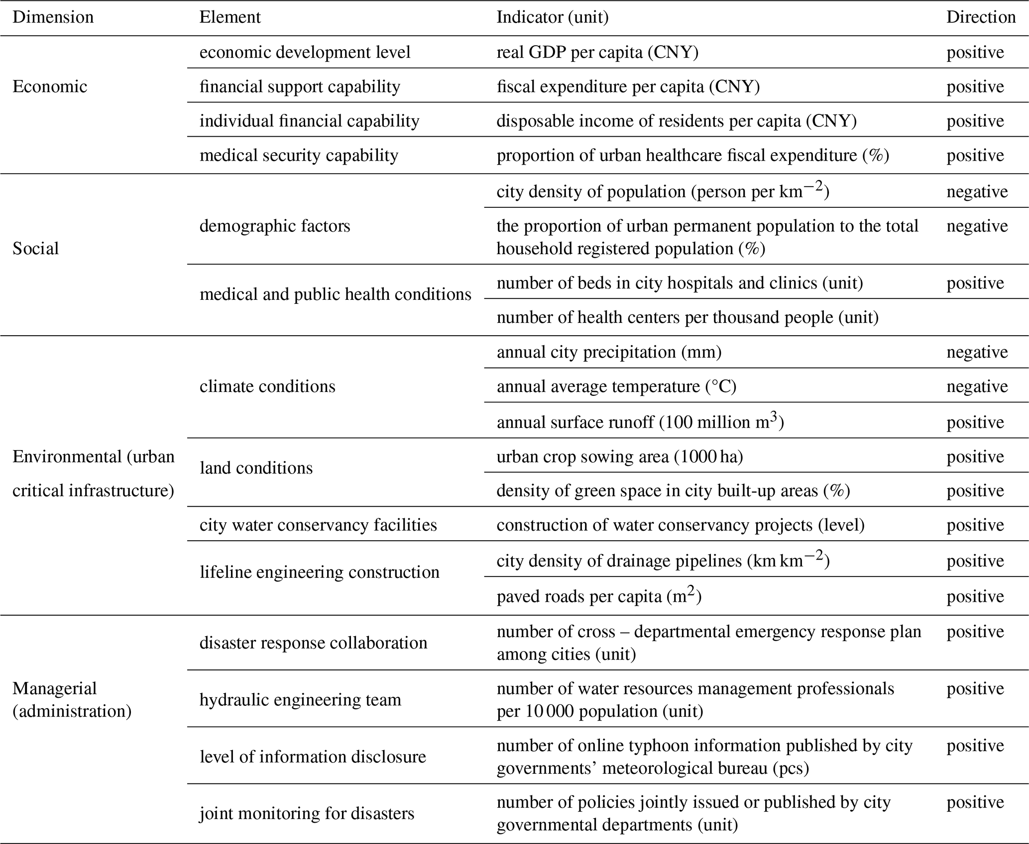
Based on studies in disaster resilience index (Song et al., 2018; Scherzer et al., 2019; Rezvani et al., 2024), we construct the assessment framework from four dimensions, and select 19 indicators to measure urban resilience to typhoon (see Table 1). Considering the potential cascading effects of typhoons, often theorized as interconnected systems, the composite indicators are integrated by adopting a multi-dimensional approach. For instance, we incorporate the critical infrastructure impact with such indicator as annual surface runoff, capacity of large reservoirs and power grids to reflect the linked influence of floods caused by typhoon. Specifically, the economic dimension measures the overall economic capacity in a city (Cutter, 2016; Hechanova et al., 2018), which encompasses the financial support capacity, individual economic support capacity, and health care capacity after suffering a typhoon. The social dimension describes the demographic and medical level and post-disaster reconstruction. Generally, densely populated cities are vulnerable to typhoon due to intensive human activities, while on the contrary, areas with lower population density are less victimized in the face of typhoon. Also, the number of hospital and health center beds per 1000 people is an indicator that can reflect urban infrastructure capacity in medical rescues. The environmental dimension includes natural and man-made condition, in which the former includes the impact of precipitation caused by typhoon, and the latter incorporates human construction, such as green space coverage rate in built-up areas, the quality of water conservancy projects, and storage of reservoirs. The managerial dimension herein is to measure the capacity of configuration in facilities and cross-departmental collaboration, for instance, the level of lifeline infrastructure, the joint collaboration of typhoon response, and the level of city's hydraulic sector information service.
Table 1Composite indicators of urban resilience for typhoon disaster.
2.2 Method
As stipulated above, the indicator-based framework has mirrored the dynamics of urban resilience and bore significant relevance to the characteristics of typhoon response. Based on this, the fussy-entropy TOPSIS method was adopted herein to assess urban resilience of sample cities. This method exhibits flexibility in accommodating various data distribution states and sample sizes, boasting a relatively accurate calculation in disaster resilience assessment (Hajek and Froelich, 2019; Zhang et al., 2021; Ekmekcioglu et al., 2021). Its core application lies the objective of identifying optimal solution and the counterpoint of negative optimal solution for each evaluated object across the weighted standardized judgment matrix. The process of the fussy-entropy TOPSIS can be obtained as referenced by Ekmekcioglu et al. (2021), which is omitted hereinafter due to layout constraints.
2.3 Data collection
All the data were acquired from the statistical yearbooks published by city governments, China's population census, the regional hydraulic bulletins, the annual reports posted on the website of meteorological department, and urban archive documents. A sample of total 27 cities in seven major river basins in China was finally selected for this study. Although typhoon is categorized in magnitudes for meteorology, such as the tropical depression, storm, severe typhoon and super typhoon, there were no data for each category across the sample cities. For this reason, we did not classify typhoon into subcategories by magnitude, and select officially disclosed information by the principle of data accessibility.
3.1 City spatial variation for typhoon resilience
By the calculation score of urban resilience (Fig. 1), cities within the seven river basin could be categorized into four levels in its capability. The smaller the level is, the stronger is the urban resilience to typhoon. In specific, cities at Level 1 to Level 3 are respectively Shanghai (average score 0.5907), Yantai (average score 0.4087), Haikou and Beijing. Level 4, rating from 0.2 to 0.3, include city of Xuzhou, Zhanjiang, Tianjin, Shenyang, Guangzhou, Harbin, Taizhou, Changchun, Hangzhou, Changsha, and Bengbu. Level 5, rating from 0.1 to 0.2, include city of Nanjing, Wuhan, Jinan, Fuzhou, Zhengzhou, Wenzhou, Yulin, Wuhu, Hefei, Nanning, and Dandong. Level 6 is labeled to Kaifeng with a composite score less than 0.1.
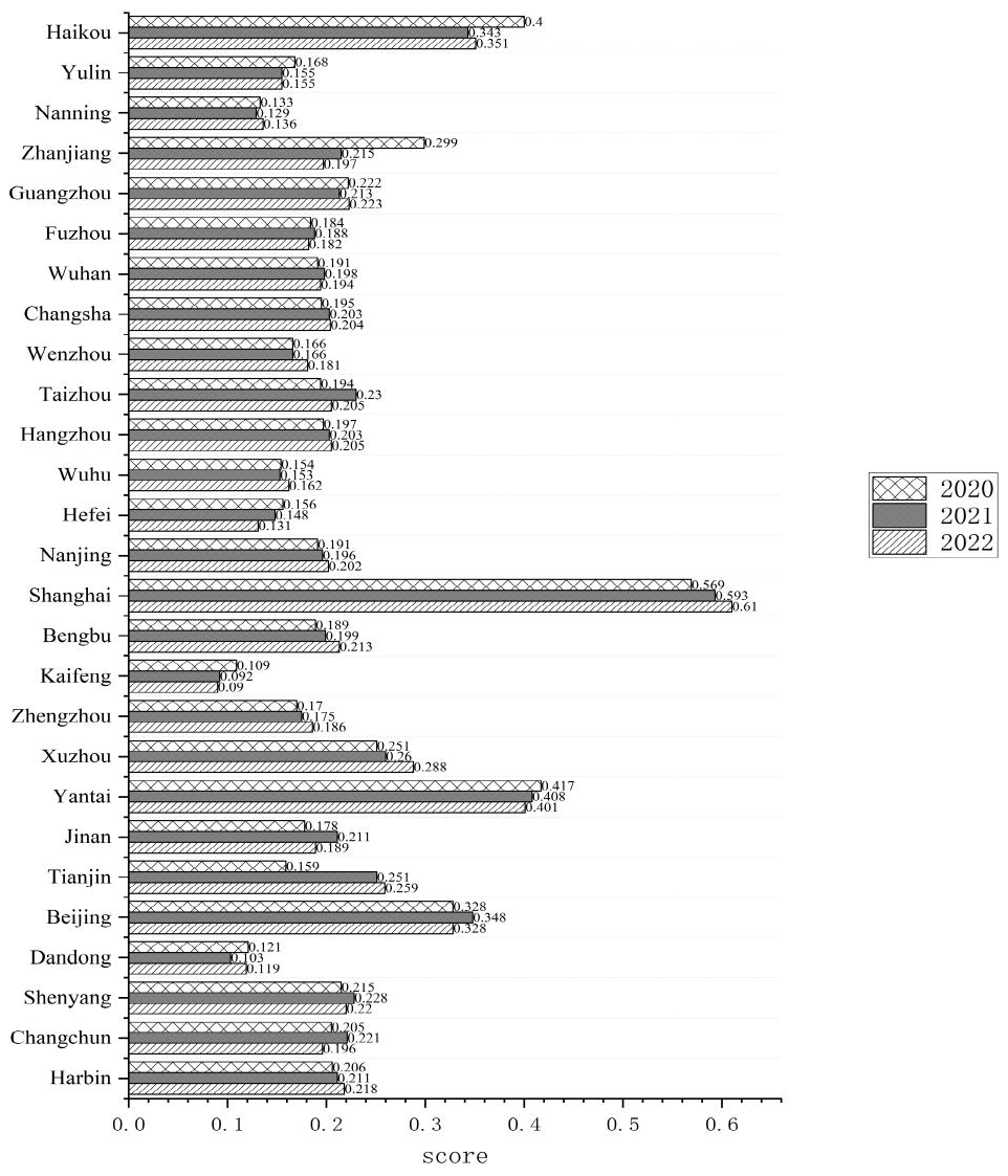
Figure 1Composite calculation score of typhoon disaster resilience for 27 sample cities. Notes: the score denotes the resilience index by rating (0–1) in the specific year. The higher the score is, the stronger urban resilient is in responding typhoon disaster
Generally, the occurrence and disastrous impacts of typhoons are affected by geographical and meterological factors. Therefore, it needs to examine the practical discrepancies in similar geographical environment. Due to the different watersheds of each city, we divided the 27 cities into seven river basin regions, and listed scores for each city under the assessing dimension.
Comparatively, the resilience scores to typhoon in northeast region (Songhua and Liao River Basin) was slightly stronger than southeast region (Pearl River Basin). Although cities in southeast region showed a rapid economic growth compared with that of the northeast region, the southeast region had a lower investment in the reservoir construction, which was one of the major economic indicators in our resilience assessment system (weight > 10 %), and the storage capacity of large and medium-sized reservoirs in the Northeast Songhua and Liao River Basins is significantly higher than that of other basins. Overall, the Pearl River Basin has a tropical and subtropical climate with an average temperature annually exceeding 22 °C and the precipitation exceeding 1500 mm (Chen et al., 2015), making them highly vulnerable to typhoons. As for the social dimension of resilience assessment, the river basin of southeast region with a higher population density acquired stronger medical and rescue capability in typhoon response, while the Northeast river basin does not possess adequate water facilities. In terms of environmental dimension, the northeast river basin had less precipitation annually and a lower risk exposure to typhoon than the southeast coastal areas. Moreover, the resilience score of the Yellow-Huai River Basin and Yangtze River Basin (including major cities in China's provinces of Shandong, Henan, Jiangsu, Zhejiang and Anhui) is stronger than that of the Northeast region. Both river basins perform better by its resilience score in terms of social and managerial dimension, which can be attributed to the high influx of R&D investment and the enhancement of technical innovation. The Yellow-Huai River Basin, located in the eastern regions of China with better climate conditions and a high level of urbanization, attracts a large inflow of economic resources and creates a better pool of specialized human resources in water conservancy and economic protection.
3.2 Intra-watershed comparison
China's administrative system endows a superior status either in economic and political aspects for provincial capitals, and these cities usually exhibit higher levels of capability to disasters than other prefecture-level ones. By the research result likewise, the provincial capital cities (e.g. Harbin, Nanjing, and Guangzhou) have higher resilience scores than other types of cities in the provincial region. In other words, these cities demonstrate more capability of resilience compared to prefecture-level cities in confronting typhoon disasters. However, there are also exceptions in some watersheds. For instance, Jinan, the capital city of Shandong Province, is slightly lower in resilience score than Yantai, a prefecture-level city in Jiaodong Peninsula, which can be attributed to two reasons. First, Yantai, a coastal industrial city, is economically prosperous because of industrial power and infrastructures, which provide substantial disaster response resources and practical experiences. For its strong economic strength and the coast-border geographical location adjacent to the Yellow Sea and Bohai Sea, the local administration was more attentive to investments in tackling typhoon. Statistics show that the proportion of expenditure spent on typhoon response in Yantai throughout the year was 3–4 times than the capital city of Jinan. Second, the population density of Yantai was relatively low compared with Jinan, which benefits the city when calculating per capita indicators in urban resilience assessment. It is particularly worth mentioning that, Xuzhou City, as the second tiers city in Jiangsu Province, exceeds many provincial capitals in resilience scores, and its composite scores show an increasing tendency annually. The wide spread of drainage network around the city and rapid construction of lifeline project since 2020 has enhanced its performance in precipitation led by typhoon, which promotes its overall environmental resilience for typhoon.
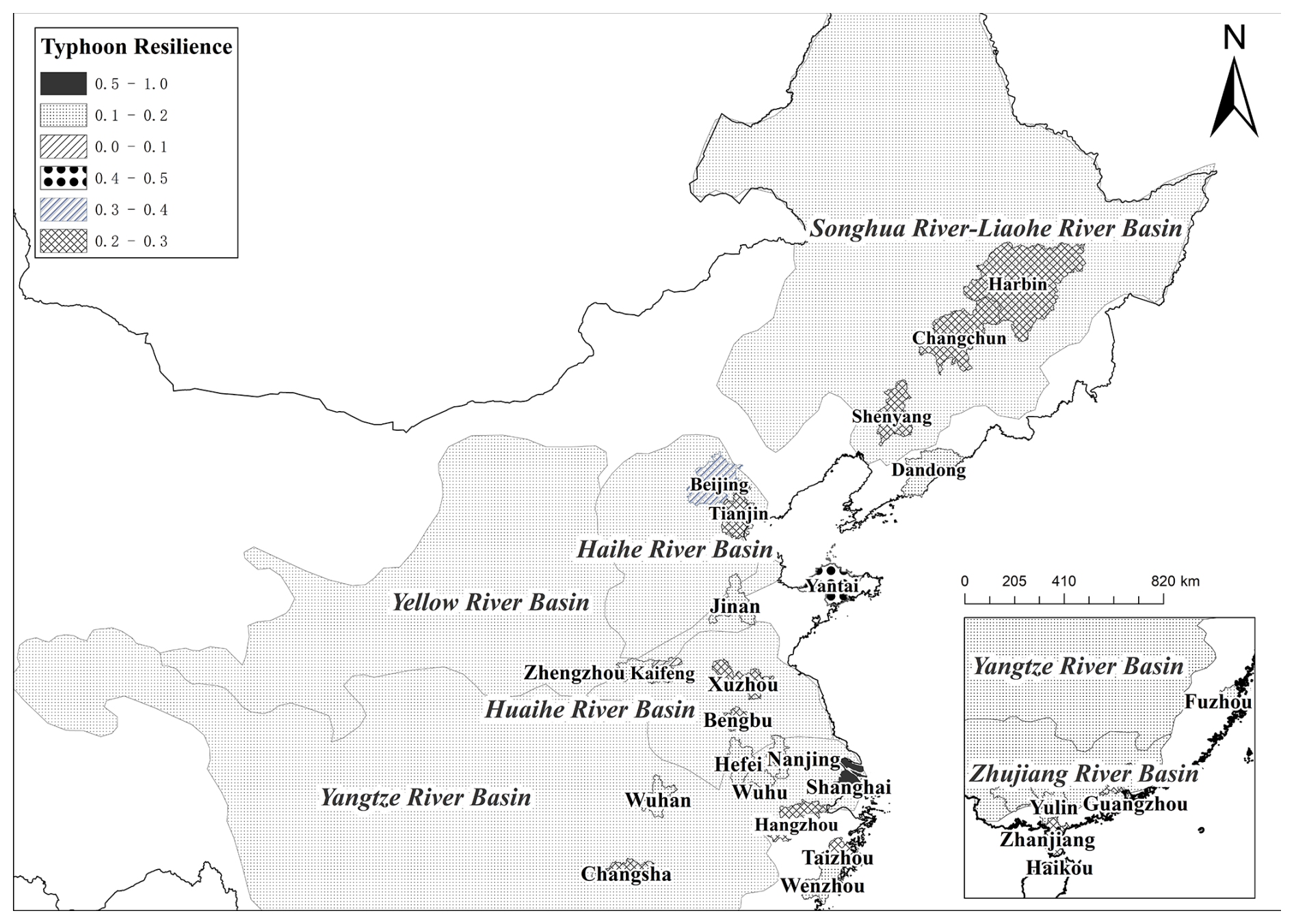
Figure 2Resilience rating for China's major river basins in typhoon disaster.
In the Songhua River Basin and Liaohe River Basin, cities perform poorly for the resilience value in economic and managerial dimension but relatively better in the social and environmental aspect. Compared to Shenyang, the capital city of Liaoning Province, Dandong has a weaker industrial base and a long coastline in Northeast China, but hold a spark advantage in water conservancy condition. In the Songhua River basin, Harbin ranks 10th out of 27 cities in the overall resilience score, while Changchun ranks 12th. This difference may be closely related to the high population density in Changchun, and weaker reservoir storage capacity compared to capital city of Harbin. For the whole northeast region in China, Harbin has the largest reservoir capacity (12 966 million m3). In the reality, reservoirs play a vital role in dissipating heavy precipitation caused by typhoon in a short period of time and staggering the peaks of rain. Moreover, the Hai River River Basin differs considerably in the resilience score, particularly among Beijing and other cities. During 2020–2022, Tianjin is significantly lower (0.2230) than Beijing (0.3347). Obviously, Beijing overwhelms others in the urban resilience of economic, social and administrative dimension, with its water conservancy sector ranking first in terms of information disclosure – risk early warning and the disaster response.
In the Yellow-Huai River Basin, the observed city with the highest level of resilience score is Jinan, which may be related to its administrative location as the capital city of Shandong province and the command center of the Liberation Army in China's Northern Theater of Operations. By the assessment result, Jinan city scores high on the resilience dimension of social and administrative aspect. Besides, Jinan has an advantage of professional talents and personnel in typhoon disaster rescues, including 27 water and disaster response practitioners per 10 000 population in 2022, far more than any other city in the river basin. By comparison, as a capital city in Henan province, Zhengzhou scored lower on the resilience calculation. The scale of inter-provincial population outflow in Henan Province is among the highest in China, resulting in a lower level of technical expertise for disaster reduction, which is one of the barriers to enhancing resilience to typhoon.
In the developed regions of Yangtze River Basin, Hangzhou has the highest level of overall resilience score, mainly due to its top ranking in the reservoir capacity and environmental management practitioners. The leading development position in the Yangtze River Delta gives the cities of Shanghai, Hangzhou, and Nanjing a very high economic advantage, attracting high-level talents from all over the country, and provide abundant talents including disaster relief and emergency aids. Among the Yangtze River Basin, Taizhou has the lowest level in resilience score, which may be related to the city's low reservoir capacity and lack of critical facilities to mitigate heavy rainfall caused by typhoon.
Cities in the Pearl River Basin are categorized into two levels, Guangzhou and ZhanJiang in Guangdong province rating the fourth and Nanning in Guangxi province rating the fifth position. The Pearl River Basin has abundant annual rainfall, accounting for about 13disclosure% of the national runoff. The Xijiang and Beijiang rivers meet as the main source of typhoon-induced flooding in the delta. Nanning and Yulin, although less pressurized in terms of population density and large reservoirs of capacity, the level of water conservancy construction and disaster relief facilities is low, leading a weaker ability to confront typhoon. From an economic perspective, Nanning and Yulin lag behind other provincial capital cities in terms of governmental fund support. Particularly, although Nanning encountered a frequent typhoon landfall, it had a small number of reservoirs for precipitation due to lack of long-term financial input, which may result in weak response capacity to sudden typhoon rain.
This communication reports a multi-dimensional framework focusing on urban resilience to typhoon disaster and applies 27 cities in China's seven major river basins during 2020–2022. Several composite indicators under the economic, social, environmental, and managerial dimension were selected and the fussy-entropy TOPSIS method was applied. We found that the urban resilience in these watersheds could be ranked from high to low: the Haihe River River Basin, the Liaohe River Basin, the Yangtze River Basin, the Songhua River Basin, the Yellow-Huaihe River Basin, the Nandu River Basin and the Zhujiang River Basin (Fig. 2). In specific, we obtain the following findings based on the resilience assessment of these basins to typhoon disaster.
The economic development level is not synchronized with resilience to typhoon in some basins. Our findings show that the resilience score in northeast China was higher than that in the southeast, which did not match the economic status of two regions. Overall, the investment direction of regional economic resources, especially government fiscal investment, and the condition of disaster prevention infrastructure are more crucial to cities' capability of tackling typhoon, rather than simply the economic growth. We found that some cities in the watershed with a higher percentage of financial expenditure on underground tunnel facilities demonstrated a stronger capacity for divert floodwaters and disaster response when typhoon occurs.
In the assessment of environmental dimension, climatic condition, land resource, and infrastructure are critical factors in affecting urban resilience to typhoon. Our research showed that cities in the coastal region with more risks of typhoon-induced rainwaterlogging scored higher, mainly thanks to its infrastructure of extensive water conservancy projects, such as large and medium-sized reservoirs, hydropower station, waterway and harbor projects. A typical case was the Fuzhou City in Fujian. Although it received more annual precipitation caused by typhoon, the large-capacity reservoirs and widely distributed air-raid shelter infrastructures reduced destructive shocks in the past decade.
The managerial dimension with respect to urban resilience herein refers to the response capacity by local administration, particularly tackling potential cascading effects of typhoon. In this study, the status of cross-departmental collaboration was an important indicator. Through fostering dynamic linkage of departments, it is conductive to form an efficient resource scheduling platform, promote a holistic response, and further enhance the systemic resilience in responding to compound risks of typhoon disaster. Moreover, the government ought to enhance the level of early warning as well as information disclosure of typhoon through the technical approaches, for instance, strengthening the integration chain of “monitoring-forecasting-dissemination” by the support of such technology as satellites navigation, supercomputer, artificial intelligence.
To sum up, we tried to provide a holistic view of typhoon resilience by constructing a composite framework, but there are still gaps that need to be filled. Urban resilience to typhoon is inherently dynamic, evolving with changes in economic, environmental, social, and infrastructure conditions, thus more heterogeneous cognitive factors need to be added. Future research could probe the conceptualization of potential cascading impacts of typhoon by novel methodologies with a dynamic perspective upon resilience assessment.
The data is available on reasonable request.
ZL: conceptualization, analysis, writing – original draft, editing and funding acquisition. JY: data curation, writing – original draft. CW: visualization, writing – review.
The contact author has declared that none of the authors has any competing interests.
Publisher's note: Copernicus Publications remains neutral with regard to jurisdictional claims made in the text, published maps, institutional affiliations, or any other geographical representation in this paper. While Copernicus Publications makes every effort to include appropriate place names, the final responsibility lies with the authors. Also, please note that this paper has not received English language copy-editing.
This research has been supported by the National Social Science Fund of China (grant no. 23BZZ049), the special program for Sustainable Development Innovation Demonstration Areas by the Xuzhou municipal administration (grant no. 23KC101), and the Education Science Planning Project in Jiangsu province (grant no. B/2023/01/140).
This paper was edited by Robert Sakic Trogrlic and reviewed by two anonymous referees.
Chen, C. K., Xu, L., Zhao, D., Xu, T., and Lei, P.: A new model for describing the urban resilience considering adaptability, resistance and recovery, Safety Sci., 128, 104756, https://doi.org/10.1016/j.ssci.2020.104756, 2020.
Chen, S., Li, W. B., Du, Y. D., Mao, C. Y., and Zhang, L.: Urbanization effect on precipitation over the Pearl River Delta based on CMORPH data, Advances in Climate Change Research, 6, 16–22, https://doi.org/10.1016/j.accre.2015.08.002, 2015.
Cutter, S. L.: The landscape of disaster resilience indicators in the USA, Nat. Hazards, 80, 741–758, https://doi.org/10.1007/s11069-015-1993-2, 2016.
Dasgupta, R., Basu, M., Kumar, P., Johnson, B. A., Mitra, B. K., Avtar, R., and Shaw, R.: A rapid indicator-based assessment of foreign resident preparedness in Japan during typhoon Hagibis, Int. J. Disast. Risk Re., 51, 101849, https://doi.org/10.1016/j.ijdrr.2020.101849, 2020.
Ekmekcioglu, Ö., Koc, K., and Özger, M.:Stakeholder perceptions in flood risk assessment: A hybrid fuzzy AHP-TOPSIS approach for Istanbul, Turkey. Int. J. Disast. Risk Re., 60, 102327, https://doi.org/10.1016/j.ijdrr.2021.102327, 2021.
Hajek, P. and Froelich, W.: Integrating TOPSIS with interval-valued intuitionistic fuzzy cognitive maps for effective group decision making, Inform. Sciences, 485, 394–412, https://doi.org/10.1016/j.ins.2019.02.035, 2019.
He, X. R.: Typhoon disaster assessment based on Dombi hesitant fuzzy information aggregation operators, Nat. Hazards, 90, 1153–1175, https://doi.org/10.1007/s11069-017-3091-0, 2018.
Hechanova, M. R., Docena, P. S., Alampay, L. P., Acosta, A., Porio, E. E., Melgar, I. E., and Berger, R.: Evaluation of a resilience intervention for Filipino displaced survivors of Super Typhoon Haiyan, Disaster Prev. Manag., 27, 346–359, https://doi.org/10.1108/dpm-01-2018-0001, 2018.
Kim, J. M., Son, K., and Kim, Y. J.: Assessing regional typhoon risk of disaster management by clustering typhoon paths, Environ. Dev. Sustain., 21, 2083–2096, https://doi.org/10.1007/s10668-018-0086-2, 2019.
Labarda, C., Labarda, M. D., and Lamberte, E. E.: Hospital resilience in the aftermath of typhoon Haiyan in the Philippines, Disaster Prev. Manag., 26, 424–436, https://doi.org/10.1108/dpm-02-2017-0025, 2017.
Marzi, S., Mysiak, J., Essenfelder, A. H., Amadio, M., Giove, S., and Fekete, A.: Constructing a comprehensive disaster resilience index: the case of Italy, PLoS ONE, 14, e0221585, https://doi.org/10.1371/journal.pone.0221585, 2019.
Meerow, S., Newell, J. P., and Stults, M.: Defining urban resilience: A review, Landscape Urban Plan., 147, 38–49, https://doi.org/10.1016/j.landurbplan.2015.11.011, 2016.
Moghadas, M., Asadzadeh, A., Vafeidis, A., Fekete, A., and Koetter, T.: A multi-criteria approach for assessing urban flood resilience in Tehran, Iran, Int. J. Disast. Risk Re., 35, 101069, https://doi.org/10.1016/j.ijdrr.2019.101069, 2019.
Nie, J., Zhang, X., Xu, C., Chen, C., Liu, L., Ma, X., and Xu, N.: The impact of super typhoon Lekima on the house collapse rate and quantification of the interactive impacts of natural and socioeconomic factors, Geomat. Nat. Haz. Risk, 12, 1385–1400, https://doi.org/10.1080/19475705.2021.1927860, 2021.
Peng, Y., Zheng, R., Yuan, T., Cheng, L., and You, J.: Evaluating perception of community resilience to typhoon disasters in China based on grey relational TOPSIS model, Int. J. Disast. Risk Re., 84, 103468, https://doi.org/10.1016/j.ijdrr.2022.103468, 2023.
Rezvani, S. M. H. S., Silva, M. J. F., and de Almeida, N. M.: Urban Resilience Index for Critical Infrastructure: A Scenario-Based Approach to Disaster Risk Reduction in Road Networks, Sustainability, 16, 4143, https://doi.org/10.3390/su16104143, 2024.
Scherzer, S., Lujala, P., and Rød, J.: A community resilience index for Norway: an adaptation of the baseline resilience indicators for communities, Int. J. Disast. Risk Re., 36, https://doi.org/10.1016/j.ijdrr.2019.101107, 2019.
Siebeneck, L., Arlikatti, S., and Andrew, S.: Using provincial baseline indicators to model geographic variations of disaster resilience in Thailand, Nat. Hazards, 79, 955–975, https://doi.org/10.1007/s11069-015-1886-4, 2015.
Song, J., Huang, B., and Li, R.: Assessing local resilience to typhoon disasters: a case study in Nansha, Guangzhou, PLoS ONE, 13, e0190701, https://doi.org/10.1371/journal.pone.0190701, 2018.
Song, J. L., Huang, B., Li, R. R., and Pandey, R.: Construction of the scale-specific resilience index to facilitate multiscale decision making in disaster management: a case study of the 2015 Nepal earthquake, Soc. Indic. Res., 148, 189–223, https://doi.org/10.1007/s11205-019-02188-8, 2020.
Wang, T., Yang, L., Wu, S. H., Gao, J. B., and Wei, B. G.: Quantitative assessment of natural disaster coping capacity: an application for typhoons, Sustainability, 12, 5949, https://doi.org/10.3390/su12155949, 2020.
Yang, R. and Li, Y.: Resilience assessment and improvement for electric power transmission systems against typhoon disasters: A data-model hybrid driven approach, Energy Reports, 8, 10923–10936, https://doi.org/10.1016/j.egyr.2022.08.226, 2022.
Zhang, H., Yang, J., Li, L., Shen, D., and Dong, S.: Measuring the resilience to floods: a comparative analysis of key flood control cities in China, Int. J. Disast. Risk Re., 59, 102248, https://doi.org/10.1016/j.ijdrr.2021.102248, 2021.