the Creative Commons Attribution 4.0 License.
the Creative Commons Attribution 4.0 License.
 | 07 Aug 2025
Invited perspectives: Thunderstorm intensification from mountains to plains
Pieter Groenemeijer
Alois Holzer
Monika Feldmann
Katharina Schröer
Francesco Battaglioli
Lisa Schielicke
Tomáš Púčik
Bogdan Antonescu
Christoph Gatzen
Severe thunderstorms are among the most damaging and impactful weather phenomena. In Europe, notable clusters occur in the vicinity of complex terrain. These areas not only experience frequent thunderstorms but also show a strong climate change signal with an increasing storm frequency. Despite the relevance of the subject, our understanding of severe convection in complex terrain, particularly in a changing climate, remains incomplete. This White Paper presents the current state of the research on thunderstorms in complex orography, covering storm severity, modification of pre-storm environments, convection initiation, storm-scale interactions with complex terrain, impactful hazards, numerical modeling and forecasting, climatologies and climate change signals, and innovative storm observations. Highlighting the gaps in our understanding, this review underscores the need for a coordinated European field campaign on thunderstorm intensification from mountains to plains (TIM). Initial plans for the TIM campaign, developed by the participating authors and institutions of this article, are briefly outlined. Obtaining coordinated and dense data on orographically driven storms is a key step toward improving warnings, forecasts, future climate projections, and adaptation measures.
- Article
(9857 KB) - Full-text XML
- BibTeX
- EndNote


Severe convective storms (SCSs) with hail, flash floods, wind gusts, lightning, and tornadoes cause a significant and increasing amount of damage across Europe and other mid-latitude regions. In 2023 alone, a new record hail size of 19 cm was set for Europe (ESSL, 2023c), while in North America, the insured loss from severe convective storms reached around USD 60 billion, thereby also setting a new record and dominating the total loss from natural catastrophes (e.g., SwissRe, 2024). These impacts highlight the importance of research on all aspects of severe convective storms to better understand where and why these hazards occur.
Reports of severe weather in the European Severe Weather Database (Dotzek et al., 2009) suggest that severe thunderstorms are most frequent over the flanking slopes of mountain ranges and the plains that straddle them. As an example, Fig. 1 shows the clustering of severe hail reports north and south of the Alps and predominantly on the eastern or northeastern flanks of lower mountain ranges (the reader may skip ahead to Fig. 7 for more topographic detail and regions of interest). This clustering of reports is supported by indirect but spatially less population-biased measures of storm severity than reports, such as overshooting storm tops (Punge et al., 2017; Giordani et al., 2024), lightning frequency (e.g., Manzato et al., 2022b), and radar-based climatologies (e.g., Kaltenboeck and Steinheimer, 2015; Punge and Kunz, 2016; Wapler, 2021; Fluck et al., 2021; Feldmann et al., 2023). The same geographic regions show a strong past and projected increase in SCS-prone atmospheric conditions as a result of global warming (Púčik et al., 2017; Rädler et al., 2019; Battaglioli et al., 2023). In addition, many of these parts of Europe are highly vulnerable because of dense population or specialized agriculture (e.g., Púčik et al., 2019). Thus, there is both a need and an opportunity to study SCSs in these regions.
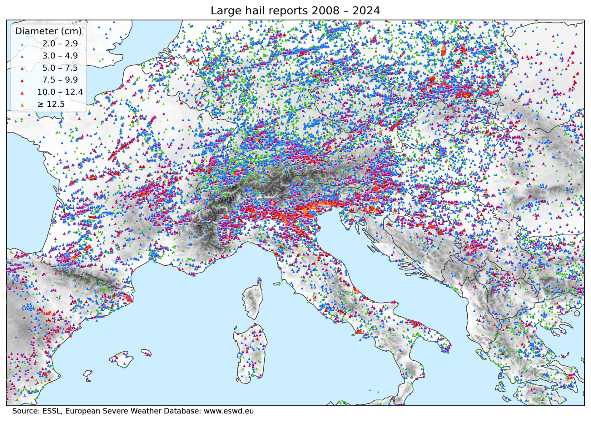
Figure 1Severe hail reports between 2008 and 2024 in the European Severe Weather Database (ESWD; https://eswd.eu/, last access: 10 March 2025). The topography is qualitatively underlaid in gray, with darker shading indicating higher terrain. For more topographic detail and the locations of Thunderstorm Intensification from Mountains to Plains (TIM) partner institutions, see Fig. 7. Publisher's remark: please note that the above figure contains disputed territories.
One key question in this regard is why storms in the vicinity of European mountain ranges are more severe. As reviewed in Sect. 2.1, there are several possible explanations in the literature. However, our understanding of thunderstorm dynamics and mesoscale atmospheric processes is still incomplete. One reason is that observational datasets to validate existing theories are scarce and, where available, are distributed across many institutions and data archives. This lack of understanding and shared data is echoed throughout the research field of severe convective storms. As a basis for this article, the European Severe Storms Laboratory (ESSL) conducted a survey with institutions in the European atmospheric science community, asking for their perspectives on the most crucial research topics on severe convective storms near mountains (Fig. 2). The contributors to this survey also took part in the writing of this article and are listed in the extended co-author section. The survey outcome was a pool of over 40 research questions, which are sorted by topic and discussed in detail in Sect. 2. A recurring theme in the responses is that a better understanding of the physical processes controlling severe convective storms and their impacts is needed. Public authorities, research institutions, the aviation industry, and the reinsurance sector share the need to better estimate the frequency, magnitude, and predictability of severe weather.
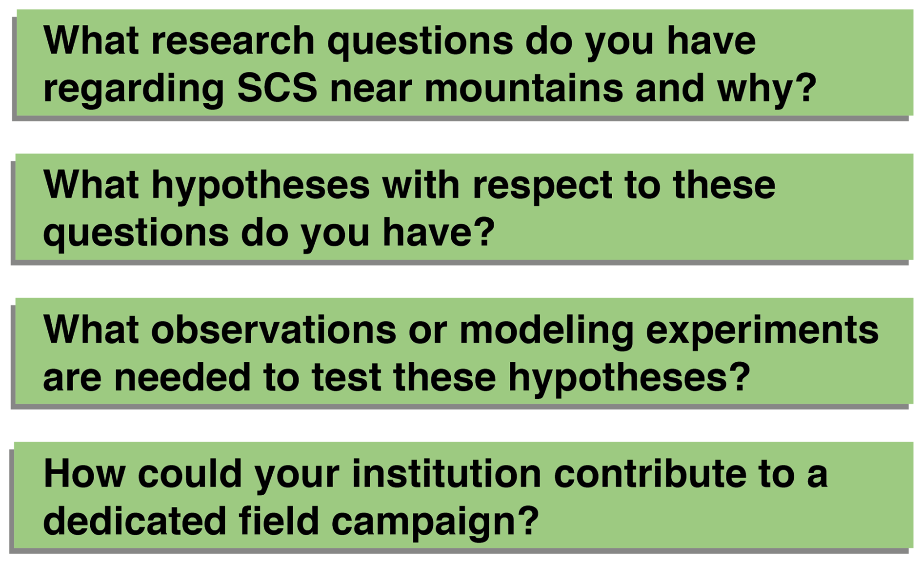
Figure 2Questions from the White Paper survey conducted for this article with the European partner institutions listed in the text.
Presently, a wealth of new sensors and data types is emerging to cater to these needs, such as the Meteosat Third Generation satellite program (Holmlund et al., 2021), numerical modeling within the DestinE project (Wedi et al., 2022), and the proliferation of polarimetric Doppler radars across Europe (Saltikoff et al., 2019). Validation of these datasets is key and requires that they are shared among scientists with the least possible restrictions. This validation is especially important near mountain ranges, not only because of the high severe-weather frequency (Fig. 1), but also because the lack of observations of basic meteorological parameters in the boundary layer and in complex terrain1 is a critical limitation to advancing forecasting and nowcasting skill (Bojinski et al., 2023).
This prominent need for shared data and research, especially near mountains, can partly be explained by the prevailing focus of past field campaigns either on thunderstorm dynamics away from mountain ranges or on terrain influences on the atmosphere but not on the scale of individual storms. For instance, several large field campaigns in the United States, such as VORTEX1/2/SE (Rasmussen et al., 1994; Wurman et al., 2012), PECAN (Geerts et al., 2017), TORUS (Houston et al., 2020), PERILS (Kosiba et al., 2024), and TRACER (Jensen et al., 2022), have led to advancements in our understanding of thunderstorm dynamics, microphysics, and processes leading to severe weather. Meanwhile, SCS-focused campaigns in Europe, such as Swabian MOSES (Kunz et al., 2022) and LIFT (Kunz et al., 2024), were relatively small, and major convective-season field campaigns in mountainous regions, such as MAP (Bougeault et al., 2001), COPS (Wulfmeyer et al., 2011), HyMeX (Ducrocq et al., 2016), and, currently, TEAMx (Rotach et al., 2022), have improved numerical models and process understanding of large-scale orographic flow, boundary layer exchange processes, autumn convective floods, and processes occurring prior to convection initiation (CI) but much less so regarding the dynamics of individual thunderstorms (e.g., Rotunno and Houze, 2007). Exceptions are RELAMPAGO and its sister campaign CACTI, which took place in western Argentina, where some of the most intense storms worldwide are heavily influenced by the Andes and Sierras de Cordoba (Nesbitt et al., 2021; Varble et al., 2021). However, the setting of RELAMPAGO in the lee of a long meridional mountain range and with the Amazon Basin as a moisture source differs greatly from Europe and other severe-storm regions of the world concerning larger-scale environments, geography, climatology, and meteorological instrument networks (e.g., Zhou et al., 2021).
Therefore, a field campaign investigating individual thunderstorm dynamics near complex terrain in the densely observable regions over Europe seems overdue, particularly given the potentially escalating storm activity attributed to climate change in densely populated regions (Battaglioli et al., 2023). To this end, ESSL is coordinating an effort for an international field campaign in Europe under the name TIM (Thunderstorm Intensification from Mountains to Plains). In this article, we summarize the most pressing research questions based on the White Paper survey and the existing literature (Sect. 2). Section 3 then provides a summary and briefly outlines how this wide range of topics can be addressed in TIM.
Our survey within the community has revealed a large pool of research topics regarding severe storms near mountain ranges. These topics are condensed in the following subsections. Section 2.1 starts with an overview of the physical processes important for thunderstorm intensification near mountains. The following sections describe the related research topics that present the main foci in TIM.
2.1 Increased storm severity near high terrain
As established above, severe convective storms tend to be frequent near European mountain ranges, which is underscored by the documented cases of impactful supercells that have tracked through such regions (Kaňák et al., 2007; Kunz et al., 2018; Trefalt et al., 2018; Šinger and Púčik, 2020; Wilhelm et al., 2021; Kopp et al., 2023). That said, it is difficult to disentangle whether it is the high storm frequency and/or stronger average intensity that drive these near-mountain severe-weather maxima.
Thunderstorm frequency is largely related to convection initiation (CI) or the lack thereof. Mesoscale orographic processes dominate CI mechanisms in mountainous regions, in contrast to synoptic-scale processes, such as fronts, which are more important over flat terrain (e.g., Pacey et al., 2023). As illustrated in Fig. 3 and discussed in more detail in Sect. 2.3, orographic CI can occur where terrain-induced flows converge and cause continuous deep lift in the atmospheric boundary layer (e.g., Kirshbaum et al., 2018), especially if these flows transport and vertically mix boundary layer moisture and thus decrease convective inhibition (CIN) and dry-air entrainment near the convergence zones (e.g., Scheffknecht et al., 2017; Serafin et al., 2020; Marquis et al., 2021; Nelson et al., 2022; Göbell et al., 2023). Hence, mountain ranges strongly influence where thunderstorms form (e.g., Nisi et al., 2018; Manzato et al., 2022b). Although severe storms can travel hundreds of kilometers (e.g., Scheffknecht et al., 2017; Kunz et al., 2018), CI-prone regions tend to have a much higher frequency and coverage of severe storms (e.g., Feldmann et al., 2023; Kvak et al., 2023). For Switzerland, Feldmann et al. (2023) demonstrated that, while the regions of the highest storm frequency and highest storm intensity strongly overlap, they are not identical (see also Nisi et al., 2018; Manzato et al., 2022a). Thus, CI is likely an important factor but not the only one.
Severe storm intensity is largely determined by the vertical distribution of temperature, moisture, and horizontal winds. Most reports of severe weather occur when certain atmospheric “ingredients” (e.g., Doswell et al., 1996) are met, which can be boiled down to (1) high convective available potential energy (CAPE), which drives deep convective updrafts and which is found where tropospheric temperature lapse rates and low-level moisture are large, and (2) strong vertical change in wind speed and/or wind direction, i.e., vertical wind shear (e.g., Thompson et al., 2003; Taszarek et al., 2020a). Given CI in regions where these ingredients are met, storms tend to become more intense, more organized, and longer-lived, often forming mesoscale convective systems (MCSs) or supercells (e.g., Markowski and Richardson, 2010). Thus, one likely reason for the accumulation of severe reports near orography is that these ingredients are enhanced. Several mechanisms exist in that regard, which are summarized in the rest of this section. Figure 3 illustrates the respective key processes.
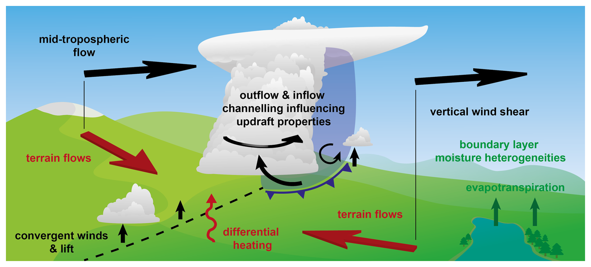
Figure 3Conceptual illustration of processes influencing severe convective storms near and over complex terrain, as explained in the text. The term “terrain flows” encompasses all possible terrain-induced near-ground flow perturbations, such as thermally forced circulation caused by differential heating, mechanically forced ascent or channeling, upstream blocking, and lee-side convergence (e.g., Kirshbaum et al., 2018).
Local terrain-induced flow systems, such as thermal slope winds and Alpine pumping (Ćurić and Janc, 2012; Soderholm et al., 2014; Trefalt et al., 2018; Mulholland et al., 2020; Trapp et al., 2020; Katona and Markowski, 2021), wind channeling (Whiteman and Doran, 1993; Hannesen et al., 1998; Ćurić et al., 2007; Geerts et al., 2009; Tang et al., 2016; Feldmann et al., 2024), or lee cyclogenesis (e.g., McGinley, 1982), can cause perturbations in atmospheric lower-tropospheric winds. This can increase the vertical wind shear and thereby severe-storm potential. Furthermore, the wind profile influences storm structure and propagation (e.g., Houze et al., 1993). Terrain flows depend on the thermodynamic stability of the atmosphere, as well as on the terrain shape and dimensions (e.g., Houze, 2012). As a result, typical flow systems seem to exist for individual mountain ranges (e.g., Dotzek, 2001; Kunz and Pusskeiler, 2010), but more universal conceptual models identifying which processes dominate under which scenarios have not been developed thus far.
Another factor is the spatial distribution of low-level moisture across complex terrain. Moisture is often relatively low directly over mountain ridges, leading to less CAPE than over the surrounding slopes and valleys (e.g., Katona and Markowski, 2021). However, water vapor content and CAPE can be increased by near-ground upslope moisture flux (e.g., from the Mediterranean; De Martin et al., 2024, 2025), evapotranspiration from lakes or vegetation (e.g., Laiti et al., 2014; Feldmann et al., 2024), or along air mass boundaries and convergence lines (e.g., Maddox et al., 1980). Due to these effects, the distribution of water vapor in complex terrain is often spatially heterogeneous, which can play a role in the formation of thunderstorms (Adler et al., 2016; Marquis et al., 2021; Nelson et al., 2021; Calbet et al., 2022). More research is needed to understand the storm-scale impacts of such heterogeneities and to reliably detect them with remote sensing.
The interpretation of the thermodynamic profile near mountains is complicated by heterogeneous heat and moisture fluxes. Nevertheless, the studies below have suggested that, with increasing elevation, near-surface air parcels that enter a thunderstorm cloud originate higher relative to the background thermodynamic profile that is advected over the terrain; i.e., inflow air does not originate near the surface. At intermediate elevation, this can lead to an increase in convective energy because the most unstable parcels are being lifted (Markowski and Dotzek, 2011; Scheffknecht et al., 2017; Katona and Markowski, 2021; Feldmann et al., 2024). At increasingly higher elevation or on the leeward side of a mountain ridge (with respect to the deep-layer winds), CAPE is typically diminished because lifted parcels from higher in the atmosphere are drier, and the depth of the CAPE layer decreases (Markowski and Dotzek, 2011; Mulholland et al., 2019; Katona and Markowski, 2021; Feldmann et al., 2024). However, these studies have only considered specific mountain ranges or idealized scenarios, and hence it remains unclear how significant these effects are in different geographic regions.
The above-mentioned convergence regions from terrain-induced flows may also overlap with moisture gradients and take characteristics of dryline-like boundaries (e.g., Pistotnik et al., 2011; LeBel et al., 2021). Such boundaries are known to have an impact on storm severity, mainly through locally enhanced low-level vertical wind shear, moisture, and lift (e.g., Maddox et al., 1980). However, mesoscale boundaries have not been well documented in Europe, although case studies indicate at least some importance for supercells that produce large hail and tornadoes (e.g., Komjáti et al., 2023; De Martin et al., 2024, 2025).
Lastly, complex terrain also influences the internal structure and processes within existing thunderstorms. This can include channeling of the outflow and inflow of a thunderstorm (Fig. 3), which in turn can feed back to storm intensification via increased storm-relative winds or baroclinic generation of horizontal vorticity (e.g., Feldmann et al., 2024). As discussed in Sect. 2.4, these storm-scale influences are complex and not well researched. Hence, much research at the storm scale is needed to better understand them, in addition to the larger-scale environmental influences in the previous paragraphs.
As suggested by Feldmann et al. (2024), it is the interplay of the factors described in this section that may cause SCS potential to be enhanced over the slopes of mountain ranges compared to flat terrain or areas directly over the mountains. Even slight enhancements are especially relevant in regions like Europe, where SCS potential is often marginal (e.g., Taszarek et al., 2020b). However, which processes are typically at play in which weather situations and sub-regions remains largely unclear and is considered one research focus of TIM.
2.2 Orographic modification of the mesoscale environment
The influence of orography on the atmosphere and parameters like CAPE and wind shear prompts several follow-up questions. What influence does the prevailing mid-tropospheric flow direction and speed have on the modification of convective parameters? Why are there regions along the Alps and other mountain chains that are much more prone to severe storms than others? What are the preferential paths for severe storms? At which elevations are environments most or least favorably modified? How significant is the impact of vegetation, water bodies, snow cover, or urban areas in mountainous regions?
Related to these topics is also how storms evolve when either crossing or moving away from mountains and hence encountering either abrupt or continuous changes in the mesoscale environment. Situations have been documented for both decay and intensification in these scenarios (e.g., Scheffknecht et al., 2017; Trapp et al., 2020; Klaus et al., 2023; McKeown et al., 2024). By documenting example cases within a field campaign such as TIM, detailed observations could help our understanding of these opposing changes.
Furthermore, it is well established that the atmospheric environments of hazards are statistically different, e.g., between tornadoes and hail (Púčik et al., 2015; Nixon and Allen, 2022). Similarly, Zhou et al. (2021) showed that there are statistically different hailstorm environments, with one of the main differentiating factors being terrain elevation. Hence, the impact of orographic modifications is likely hazard-dependent. Several studies have shown that channel winds in relatively narrow valleys improve the conditions for supercell tornadoes even if the background environment is otherwise unfavorable (Fujita, 1989; Dotzek, 2001; Bosart et al., 2006; Tang et al., 2016). Whether there are similar mechanisms specifically for hail or other hazards is relatively less researched. Targeted observations and measurements, as well as simulation studies (e.g., Katona et al., 2016), over different Alpine sub-regions as part of the TIM campaign could provide deeper insights into the processes of orographic modification.
2.3 Convection initiation
Due to its importance for thunderstorm evolution, CI has been a focus of past research. The reader is referred to Houze (2012) and Kirshbaum et al. (2018) for reviews on the topic. Large low- to mid-level relative humidity, dry-air entrainment, and strong and deep ascent are among the most crucial factors for CI (e.g., Nelson et al., 2022; Marquis et al., 2023). Whether near-ground convergence and ascent occur upstream of, over, or downstream of a mountain ridge (Fig. 3) depends on the speed of the flow impinging on the terrain obstacle, the stability of the atmosphere, and the shape and dimensions of the ridge (e.g., Kirshbaum et al., 2018; Imamovic et al., 2019). However, in reality, individual flow and moisture perturbations are extremely complex and subject to strong diurnal cycles (e.g., Zardi and Whiteman, 2013; Adler et al., 2016). On this local scale, terrain-induced flows (e.g., Schmidli, 2013; Panosetti et al., 2016), land use and urban heat islands (e.g., Niyogi et al., 2006; Zhao and Wu, 2018; Liu and Niyogi, 2019), and outflow from existing storms (e.g., Soderholm et al., 2014) strongly influence the convergence regions in addition to the larger-scale flow. Furthermore, mountain slope has a strong influence on the advection of moisture and thereby on CI likelihood (Göbell et al., 2023).
These processes make CI more “reliable” over mountains compared to over flat terrain and thereby increase the predictability of convective precipitation in forecast models (e.g., Bachmann et al., 2020; Khodayar et al., 2021). However, this is not the case for other SCS hazards. Since small details in the timing and location of the CI can have a profound impact on the evolution and organization of severe convective storms, failure to resolve all relevant processes in numerical models remains a main cause of forecast error. For that reason, CI is an important topic to the weather services that contributed to this article and a focus of current and recent research (e.g., the past COPS and RELAMPAGO campaigns and the current TEAMx campaign; Wulfmeyer et al., 2011; Nesbitt et al., 2021; Serafin et al., 2020; Rotach et al., 2022).
By focusing explicitly on SCS conditions, TIM can make an important contribution to the research on CI. This includes a better understanding of CI location relative to mountains (e.g., Nisi et al., 2018; Manzato et al., 2022b) by documenting the boundary layer evolution, thermal circulations, and convergence lines before and during CI. The interplay of dry lines and triple points (De Martin et al., 2024), cold fronts (e.g., Pacey et al., 2023), sea-breeze circulations (e.g., Jensen et al., 2022), frontal waves, and gravity waves (e.g., Mulholland et al., 2020) with complex terrain requires further research as well. For instance, the maximum in large-hail reports over northern Italy and the occurrence of tornadoes in the same region appear to be linked to the combined effects of mesoscale boundaries and sea breezes separating the dry mountain boundary layer from the marine boundary layer over the warm Adriatic and Ligurian seas (Bagaglini et al., 2021; De Martin et al., 2024, 2025).
Another important scientific question concerns scenarios in which CI is suppressed. Several White Paper survey participants noted that on days with high severe-weather potential and predicted SCS activity in forecast models, storms frequently fail to occur or form with a delay. Some participants pointed out that this often happens on days with high concentrations of Saharan dust, which is typically advected over Europe together with conditionally unstable air masses (e.g., Seifert et al., 2023; Brennan and Wilhelm, 2024). This dust can decrease radiative warming at the surface, thereby suppressing boundary layer mixing and CI and increasing warming aloft, which may reduce CAPE (Stanelle et al., 2010). These processes are not implemented in most operational forecast models (e.g., Seifert et al., 2023). Assimilating in situ aerosol measurements (e.g., Eirund et al., 2022) or remote-sensing data from lidars or the recently launched EarthCARE satellite (see Sect. 2.8) could therefore reduce forecast errors in severe convection.
More generally on the topic of aerosols, their role in cloud microphysics and dynamics is a focus of current atmospheric science research and is still somewhat uncertain (e.g., Morrison et al., 2020). Regarding severe convection, aerosol concentrations can, for example, have a direct influence by acting as cloud-condensation or ice nuclei (CCNs or INPs), thereby influencing hydrometeor concentrations and thus storm dynamics (e.g., Loftus and Cotton, 2014; Allen et al., 2020; Varble et al., 2023; Barthlott et al., 2024; Brennan and Wilhelm, 2024). Based on this mechanism, cloud seeding for hail suppression is still widely used in Europe, despite the majority of scientific evidence pointing against its effectiveness as it is used now (e.g., Browning and Foote, 1976; Knight et al., 1979; Auf der Maur and Germann, 2021). Much more dubious is the use of hail cannons (Wieringa and Holleman, 2006). More effective ways of damage prevention should be pursued. A better understanding of aerosol effects, as well as outreach and education as part of TIM (Sect. 2.5), could help in that regard.
2.4 Storm-scale interaction with complex terrain
How the internal structure of thunderstorms changes in response to terrain shape is not well understood due to the lack of high-resolution observations within or around thunderstorms. Some insights exist from idealized modeling studies. Based on qualitative experience with storms in the southern pre-Alps, Feldmann et al. (2024) analyzed the interaction of a supercell storm with a simplified ridge and sloped terrain in highly idealized simulations. They showed that channeling of storm-generated outflow and inflow can affect baroclinic horizontal vorticity generation, low-level wind shear, and storm-relative inflow, all of which have an influence on supercell structure and intensity (e.g., Rotunno and Klemp, 1985; Peters et al., 2020). These findings are largely consistent with previous idealized simulations (e.g., Markowski and Dotzek, 2011; Scheffknecht et al., 2017) and the general observation that supercells can traverse and intensify over mountain ranges (e.g., Kvak et al., 2023; McKeown et al., 2024). What seems most needed now is to validate the simulated dynamical processes in real supercells over a large spectrum of cases and types of terrain, an endeavor that requires considerable effort and coordination. Similarly interesting are some non-supercell storms, such as pulse storms (Miller and Mote, 2017), which can produce large amounts of hail for a short time for unknown reasons and which are difficult to anticipate.
On larger spatial scales than individual storm cells, several studies have investigated the interaction of mesoscale convective systems (MCSs) with orography. These systems are typically driven by lift along the gust front of the cold pool (Markowski and Richardson, 2010, Chap. 9), which can be decelerated, accelerated, or blocked by mountains, thereby leading to phases of updraft and precipitation intensification and weakening, respectively (Frame and Markowski, 2006; Reeves and Lin, 2007; Letkewicz and Parker, 2011; Smith et al., 2014; Pucillo et al., 2019; Wu and Lombardo, 2021; Lombardo and Kumjian, 2022). Hence, mountains play important roles in upscale growth from single cells to MCS formation, the system's movement, and – in some cases – also its decay. The precipitation enhancement of MCSs over orography is one of the reasons for flooding events in mountainous regions (e.g., Saharia et al., 2017). Another reason is that the lift mechanisms near terrain can lead to repeated re-formation, i.e., “backbuilding” of convective cells, which means that precipitation accumulates over the same location over a long time (e.g., Soderholm et al., 2014; Panziera et al., 2015; Kirshbaum et al., 2018). The additional lift along gust fronts of storm outflow, which is influenced by the terrain slope and the environmental temperature and wind profile, plays an important role in these scenarios (e.g., Miglietta and Rotunno, 2014).
Even though past research has helped to increase forecast accuracy, high-precipitation events remain difficult to predict and are the focus of many weather services in the Alpine and Mediterranean regions, according to our partner institution survey. Unfortunately, they are also difficult to observe accurately. For example, radars are used for quantitative precipitation estimation (QPE; Ryzhkov et al., 2022) but have weaknesses over complex terrain. Radar beam blocking (e.g., Kaltenboeck and Steinheimer, 2015) and large vertical gradients of precipitation below the melting layer (e.g., Chen et al., 2023) often lead to underestimates of the QPE. As discussed further below, high-resolution precipitation surface and vertical profile measurements, as well as gap-filling radars, aimed to be collected in TIM, could be used to improve correction algorithms of QPE and aid in flooding nowcasting and response.
Similar accelerations in thunderstorm outflow to those in MCSs can be expected for downbursts impinging on and channeled through complex terrain. Downbursts cause damaging winds when colliding with the surface and spread out horizontally from the high-pressure region of the cold pool, giving rise to toroidal vortex structures (e.g., Fujita, 1990; Canepa et al., 2023). Due to their small spatial and temporal scales, the dynamics of downbursts over complex terrain are not well understood and require further research with high-density observations and simulations (e.g., Canepa et al., 2020; Burlando et al., 2024).
2.5 Storm impacts on infrastructure and society
Damages from severe convective storms with tornadoes, wind gusts, hail, extreme rainfall, or lightning, including secondary impacts such as landslides, are one of the dominating drivers of global insured loss from natural catastrophes (SwissRe, 2024). Developing a better understanding of these impacts is a prerequisite to developing adequate measures to mitigate losses. A subtopic that has received renewed attention in recent years is the mechanical or engineering perspective of severe convective hazards. Regarding tornadoes, which are still underestimated in many European countries (Antonescu et al., 2017), ESSL has recently proposed an international Fujita (IF) scale for tornado ratings based on wind damage indicators that can be used internationally, not just in the US where the enhanced Fujita scale is used based on US infrastructure (ESSL, 2023a). More data from tornado damage surveys will continue to improve the IF scale. In contrast, flash flood damage in complex terrain is strongly linked to rainfall–runoff processes and is thus, from an impact perspective, a hydrological problem (e.g., Ravazzani et al., 2016; Marvi, 2020; Merz et al., 2020). However, accurately representing SCSs in numerical models is crucial for providing background data to hydrologic models (next section).
The collection of large hailstones, 3D scanning and analysis of their internal layers, and the study of kinetic energy impacts on structures such as roof shingles are increasingly pursued by different groups, such as the Insurance Institute for Business and Home Safety (IBHS) in the US (Brown and Giammanco, 2013), the Northern Hail project in Canada (Brimelow et al., 2023), and the Bureau of Meteorology in Australia (Soderholm and Kumjian, 2023). Impact studies can, for example, help establish building codes to prevent hail damage. Schmid et al. (2024) recently showed that the lack of accurate information on hail occurrence, size, and distribution also hampers damage assessments and risk modeling efforts, which are important for insurance and reinsurance companies. Economic growth (e.g., more cars, solar panels, greenhouses) is a major driver of the increasing trend in SCS losses (SwissRe, 2024). Thus, it is important to quantify the damage and loss that can be expected from hail, wind, or their particularly damaging combination: wind-driven hail (Morgan and Towery, 1976), which is currently difficult to predict. The comparison of 3D scanned and dissected hailstones and hail size distributions between different continents, elevations, and climatic regions could also provide valuable insights into hail growth (Soderholm and Kumjian, 2023).
The impact of severe weather on society is strongly dependent on human behavior and risk perception (e.g., Ripberger et al., 2019). Unfortunately, public education on severe convection storms is limited throughout Europe, perhaps because of the relative rarity of such events and limited cross-border exchange. This may affect people's trust in severe-weather forecasts and how they perceive a severe-weather threat. For instance, appropriate safety measures and behavior when encountering tornadoes, large hail, strong winds, or lightning are typically not common knowledge. ESSL and the TIM partners share the goal of improving this through internal exchange on better impact-based warning practices, exchange with national civil protection agencies, and education and outreach at TIM measurement sites and in the media during the field campaign. Furthermore, the topic of severe convective storms is also somewhat underrepresented in university courses, especially compared to in the US, where most severe-weather research groups are situated. TIM aims to engage students from European universities in the field campaign and thereby to help build the next generation of severe-weather forecasters and researchers.
2.6 Improvements in NWP
Numerical weather prediction (NWP) models are an important basis for severe-weather forecasts. The following NWP strategies are particularly useful for capturing the chaotic nature of SCSs. Short-term NWP forecasts for the next few hours can be blended with information from nowcasting systems that extrapolate observations collected in real time (e.g., Bojinski et al., 2023). Additionally, the models can be initialized very frequently, every hour or even less, in rapid update cycles (Benjamin et al., 2004), assimilating a range of observations available at that time (Miyoshi et al., 2016). Often, an ensemble of multiple simulations is performed, whereby the initial state or the evolution of the predictions is subtly perturbed. The uncertainty resulting from small differences in initial conditions, CI, or storm interactions can thus be reflected (Durran and Weyn, 2016; Bachmann et al., 2020; Bojinski et al., 2023).
Despite these advances in severe-weather forecasting techniques, notable forecast errors can occur when NWP models fail to predict CI or the type of convective system. Over complex terrain, such errors are frequent because crucial processes like moisture advection or terrain-induced flow systems are not captured by the model (e.g., Panosetti et al., 2016). For example, on 19 July 2023, a series of record-breaking hailstorms occurred across northern Italy as intense supercells initiated over the southern Alps and moved across the plains. Operational NWP models either failed to produce the storms or underestimated their intensity (Fig. 4). In this and other challenging cases (e.g., Mandement and Caumont, 2021), a big unknown was how storms would behave once they moved out of the mountains and onto the plains: they may intensify or decay. This transition from mountains to plains seems neither well understood from a storm-dynamics perspective nor generally well predicted by NWP models.
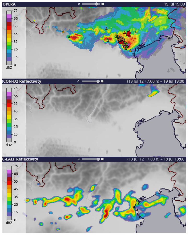
Figure 4Composite radar reflectivity (OPERA) and ESWD hail reports over northern Italy on 19 July 2023 (green: hail diameter 2–5 cm; orange: hail diameter 5–9 cm; red: hail diameter > 10 cm) and +7 h forecast reflectivity by two operational NWP models: ICON-D2 and C-LAEF. The supercell producing the extremely large hail between 18:00 and 19:00 UTC was missed by ICON-D2. C-LAEF forecasted convection but with weaker maximum intensity.
It is known that NWP models have shortcomings near mountainous terrain as their horizontal resolution is only sufficient to resolve the topography to a certain extent. The smoothing at the smallest resolved scales affects how well the interaction between the surface and the lowest layers can be represented (e.g., Rotach et al., 2022). Furthermore, the parameterizations for unresolved surface–atmosphere exchange processes were mostly developed for flat terrain and much coarser grids, which introduces considerable errors across steep topography (Ceppi et al., 2013). Neglecting or simplifying subscale effects and using climatological fields in parameterizations are perhaps unfitting assumptions in NWP models. This includes challenges of numerical model “grey zones”, where resolved processes and parameterizations overlap (e.g., Chow et al., 2019; Kramer et al., 2020; Kirshbaum, 2020; Wei and Bai, 2024). Methods used for convective-scale data assimilation are not as advanced as for global models (Gustafsson et al., 2018). Improving these terrain-related processes in models is the subject of research within the TEAMx project (Rotach et al., 2022). Modeling experiments within TEAMx regarding CI (Serafin et al., 2024) can be built upon within TIM.
Furthermore, the exceptionally high spatial and temporal resolution of TIM data is of particular interest, given that the latest generation of (pre)operational regional NWP models achieve grid spacings of 1 km and below (e.g., MeteoSwiss' ICON-D1 and ICON-D05), which is also planned for global models such as the Extremes Digital Twin by the EU Destination Earth program (ECMWF, 2023). Field campaign data from drones, surface observations, Doppler wind lidars, and other sources are useful for model comparison and data assimilation studies (e.g., Adam et al., 2016; Fourrié et al., 2021; Sgoff et al., 2022; Nomokonova et al., 2023; Demortier et al., 2024). Since the presence of orography is still often neglected in current NWP postprocessing algorithms (e.g., Schwartz and Sobash, 2017), such observations would also allow for the identification of physically based predictors and targeted observations that could locally improve the calibration of ensemble prediction, nowcasting systems, and machine learning techniques for severe-weather warnings in regions influenced by mountains (e.g., Dabernig et al., 2017).
Another potential area of NWP improvement is better handling of microphysical processes within storms (Morrison et al., 2020). Many uncertainties remain regarding the actual concentration, properties, and number of particles in the various hydrometeor classes (cloud water, rain, graupel, snow, hail) because of a lack of data as research aircraft tend to avoid the most intense parts of those storms (e.g., Heymsfield et al., 2023). However, relatively recent innovations, including drones, neutrally buoyant sondes, and vertically pointing radars (Trömel et al., 2017; Sokol et al., 2018), in addition to polarimetric radars, disdrometers, and aircraft in situ observations, offer new possibilities that are crucial for the improvement of parameterizations (e.g., Taufour et al., 2018).
Overall, addressing the following areas within TIM is likely to lead to progress in NWP performance: (1) characterizing the pre-convective environment across complex terrain by developing better data assimilation procedures (e.g., Gustafsson et al., 2018; Bachmann et al., 2020), (2) improving parameterizations for surface–air interactions (Ceppi et al., 2013; Goger et al., 2019; Rotach et al., 2022) and microphysics (e.g., Labriola et al., 2019; Malečić et al., 2022), (3) improving data assimilation of ongoing convection in satellite and radar, and (4) assimilating data from novel sources. As discussed further in Sect. 2.8, the new generation of geostationary meteorological satellites (Meteosat Third Generation, MTG) enables more accurate atmospheric moisture determination and a lightning imager, which can be assimilated into NWP models and used in nowcasting (Leinonen et al., 2023).
2.7 Climatology and climate change
Pan-European severe convective storm climatologies have been produced based on different data, such as severe-weather reports, lightning, satellite products, and reanalyses (Punge et al., 2017; Taszarek et al., 2019, 2020a; Manzato et al., 2022b; Lombardo and Bitting, 2024). These studies agree relatively well on a main convective season in summer over most of Europe, except over Mediterranean regions, where activity peaks in autumn but with relatively low severity (except flood events). As discussed in the Introduction, summertime hotspots for severe convective storms are found near mountain ranges, for example around the Alps, the Pyrenees, the Massif Central, the Black Forest, the Dinaric Alps, and the Carpathian Mountains. Continued improvement in report networks like ESWD; public user reports via apps; and SCS detections from satellite, radar, and lightning networks will provide further details on where severe storms typically initiate, become severe, and decay (e.g., Nisi et al., 2018; Manzato et al., 2022b). New data gathered in TIM is limited in time and cannot directly assess these climatological features, long-term variability, and the effects of climate change. Yet, results from a constrained field campaign can be of immense value for these research areas by improving process understanding or by probing “analog” storms that occur in conditions presumably representative of future climate conditions (e.g., Lasher-Trapp et al., 2023).
As one effect of global warming, the increase in average temperature throughout the troposphere and associated scaling in moisture content are generally expected to increase CAPE and hence thunderstorm severity (e.g., Romps, 2016; Agard and Emanuel, 2017; Martín et al., 2024). This upward trend is robust for Europe both for past and projected trends in CAPE or related thermodynamics parameters (Mohr and Kunz, 2013; Mohr et al., 2015; Púčik et al., 2017; Rädler et al., 2019; Battaglioli et al., 2023). Stronger updrafts in high-CAPE environments are one factor that increase the likelihood of flash floods, in addition to higher moisture content and slower storm motion (e.g., Kahraman et al., 2021). In its Sixth Assessment Report, the Intergovernmental Panel on Climate Change (IPCC) states that climate models consistently project environmental changes that would likely lead to an increase in the frequency and intensity of severe thunderstorms (Calvin et al., 2023, Chap. 11). However, there is low confidence in the specifics of these projected increases.
One reason for the high uncertainty is that many climate models have a bias in low-level moisture and CAPE (e.g., Gopalakrishnan et al., 2025). Another problem is that factors other than thermodynamics exist, which could counterbalance the positive trend in CAPE and which are not as well understood (e.g., Raupach et al., 2021). For one, convective inhibition and entrainment are likely to increase in a warmer climate, which could lead to decreases in frequency and coverage of SCSs (e.g., Trapp and Hoogewind, 2016; Chen et al., 2020; Peters et al., 2024). The area affected by hail is also likely to decrease because of an increase in the melting layer depth, although large hail is less affected and is expected to become more frequent due to the positive trend in CAPE (e.g., Gensini et al., 2024). Complicating this, Lin and Kumjian (2022) have indicated that increases in CAPE do not necessarily cause storms to produce larger hail, although the extreme values of CAPE they considered are relatively rare in Europe (e.g., Taszarek et al., 2020b). Furthermore, the frequency and the typical thunderstorm organization could change in response to modifications in the larger-scale circulation and resulting weather patterns (e.g., Mohr et al., 2020; Ghasemifard et al., 2024). This is important because severe convective wind gusts and extreme precipitation are often associated with MCSs (Saharia et al., 2017; Gatzen et al., 2020; Pacey et al., 2021), while most large hail and strong tornadoes are produced by supercells, at least in the US (Blair et al., 2011; Smith et al., 2012; Blair et al., 2017). For Europe, this is likely similar but only researched in certain regions (Tuovinen et al., 2015; Wapler, 2017; Feldmann et al., 2023; Wells et al., 2024).
It is unclear how accurately climate models capture these circulation changes. The accuracy of climate models across mountainous areas may also be impaired by systematic errors in modeling surface–atmosphere exchange processes across complex terrain (e.g., Rotach et al., 2022). Another more general limitation of climate models for convective storm research is that most of them still depend on convection parameterization, though research with convection-permitting climate simulation is currently ongoing (e.g., Kahraman et al., 2021, 2024; Lenderink et al., 2025; Feldmann et al., 2025). First results suggest regionally varying trends in Europe but a general decrease in the frequency of weak hailstorms and an increase in intense hailstorms (Thurnherr et al., 2025; Brennan et al., 2025). However, on the impact side, economic growth and the resulting increase in vulnerability and exposure are likely more important (e.g., SwissRe, 2024). Unfortunately, observations that are not biased by economic factors, unlike reports or insured losses, and that exist over periods long enough for climate trend analysis, are scarce. Augenstein et al. (2024) showed predominantly negative trends in lightning over central Europe, although it is somewhat unclear how representative lightning is of SCSs. Hail pad networks indicate less small and more large hail, but these trends are for small regions and mostly not significant (Manzato et al., 2022b, a).
In short, more research beyond the trends of convective parameters such as CAPE seems required to gain more robust knowledge on trends in severe weather. This is where even a relatively short-term field campaign can help because a better fundamental understanding of the storm dynamics, microphysics, CI, and production mechanisms of severe convective hazards is needed to know what signals to look for in climate projections and to anticipate how these processes may change in a warmer climate.
2.8 Innovative observations and their use
Advances in severe-storm research and forecasting have often been linked to the development and improvement of new observational techniques such as radar or satellite (e.g., Brooks et al., 2019). Many new methods and instruments are currently being developed or implemented, which could likewise improve our understanding of severe convective storms. As discussed further in this section, this includes new polarimetric radar algorithms, drone-based observations, swarmsondes, microwave links, and new instruments on geostationary and polar-orbiting satellites. A field campaign on convective storms in the following years would be ideal to test these new platforms and to validate their performance against other observations.
For one, the evolution of storm-top features, as seen from satellite imagery, is linked to storm severity. These features include above-anvil cirrus plumes, warm wake areas, large overshooting tops, and storm-top divergence (e.g., Homeyer et al., 2017; Bedka et al., 2018; Murillo and Homeyer, 2019; O'Neill et al., 2021; Murillo and Homeyer, 2022; Scarino et al., 2023). Questions remain about how these characteristics translate to the Meteosat Third Generation (MTG) satellite imagery and how indicative these features are in rapidly changing conditions near complex terrain. Novel and more precise information on cloud top properties, cloud-ice content, precipitation, and aerosol properties will be provided by METimage, the Ice Cloud Imager (ICI), and the Multi-Viewing Multi-Channel Multi-Polarisation Imaging (3MI) instruments on the polar-orbiting Metop-SG satellites as of 2026.
Lightning is another type of dataset that can be detected with a variety of methods and provides valuable information about the microphysics and severity of a thunderstorm. The new satellite-based MTG Lightning Imager (LI) is similar to the Geostationary Operational Environmental Satellite (GOES) Geostationary Lightning Mapper (GLM) over the Americas (Rudlosky et al., 2020) but requires validation with ground-based lightning sensors before it can be used in research or assimilated in forecast models. In addition to the LI and 2D lightning detections, lightning mapping arrays (LMAs) can be deployed to study the 3D electrification and polarity in thunderstorms, as was done during RELAMPAGO (Medina et al., 2021). Many mechanisms for cloud electrification have been proposed (e.g., Pruppacher and Klett, 2010), and it has been shown that even slight differences in the environment can have profound effects, which is an active field of research (Carey et al., 2003; Carey and Buffalo, 2007; Fuchs et al., 2015; Schultz et al., 2015; Chmielewski et al., 2018; Ringhausen et al., 2024). Examples to be investigated in TIM are changes in the lightning activity, polarity, and flash size (e.g., Figueras i Ventura et al., 2019; Erdmann and Poelman, 2025) of the storms that traverse complex terrain and undergo rapid changes in response to environmental characteristics such as CAPE, vertical wind shear, cloud base height, or warm cloud depth. These could be linked to the microphysics of the storm assessed through polarimetric radar (e.g., Kumjian and Ryzhkov, 2008), hail collection, and in situ observations within clouds. A better understanding of these processes would allow for the development of parameterizations and better lightning prediction in NWP models (e.g., Cummings et al., 2024).
Furthermore, vertical profiles of the atmosphere are invaluable for severe-storm forecasting and research because they allow for quantification of the ingredients of severe storms (e.g., Doswell, 1987; Doswell et al., 1996). As touched on in Sect. 2.1 and 2.3, the distribution of moisture both vertically and horizontally plays an important role in convective storms. The new 0.9 µm channel of the MTG Flexible Combined Imager (FCI) instrument allows, for the first time, quasi-continuous monitoring of total column moisture content, including in the lowest few hundred meters of the troposphere, with sampling rates over Europe of 10 min (available now) and down to 2.5 min (by around 2027). Such data could help forecast CI through detecting local boundaries or identify potential for backbuilding convection. The FCI and the new geostationary infrared sounder (IRS) on board MTG-S1, which can also provide vertical profiles of temperature and moisture, require comparison with in situ soundings and ground-based radiometer soundings near orography and in proximity to SCSs. The potential value of IRS as a complement to standard soundings has been demonstrated at the ESSL testbed in a quasi-operational setting (Groenemeijer, 2019). Although there are limitations in detecting low-level moisture near the ground with these data, the availability of infrared soundings from geostationary orbit at 30 min resolution over Europe will add significant value and overcome the current limitations in temporal resolution of such data from polar-orbiting instruments, such as IASI on Metop. Despite this disadvantage of polar-orbiting satellites, EarthCARE (Wehr et al., 2023) shows promise for profiling cloud microphysical properties and aerosols, with an overpass time of around 13:30 UTC over Europe, a typical mature convective storm period.
Recent alternative profiling methods are commercial microwave links (CMLs) and uncrewed aircraft systems (UASs or meteodrones). As an opportunistic remote-sensing tool, CMLs, typically used in cell towers, are rapidly evolving, and E-band CMLs are increasingly being installed in several countries to enable 5G. E-band CMLs can provide information on water vapor variability (e.g., Fencl et al., 2021). Research is needed to fully exploit the fast-developing K-, E-, and W-band CML networks for use in precipitation and water vapor monitoring in terms of retrievals and direct data assimilation at different frequencies. Regarding UASs, in situ aerial measurements with meteodrones of the lower troposphere were tested as high up as 6 km above ground (Guay et al., 2023), compared against radiosonde and remote-sensing instruments (Hervo et al., 2023), and were found to meet the WMO requirements (WMO, 2024). Despite the limitations of drones due to strict airspace regulations and maximum operable wind speeds, they could offer a low-cost way to collect high-resolution 3D data that are difficult to attain with conventional point measurements.
Other drone applications are for photographic documentation purposes. Cloud, dust, and rain- and hail-shaft development can be observed in time-lapse mode without the limitations imposed by buildings or vegetation being obstacles to the ground-based observers. Photographic post-event analysis of rain damage, hail damage, and wind damage (ESSL, 2023b) and analysis of hail size distribution are feasible based on images taken from drones (Soderholm et al., 2020; Lainer et al., 2024). High-resolution satellite imagery can be used in a similar way for some applications (Shikhov and Chernokulsky, 2018; Gallo et al., 2019; Kunkel et al., 2023).
The global advent of dual-polarization radar data has enabled the identification of polarimetric signatures linked to the dynamic and microphysical processes in storms (e.g., Kumjian and Ryzhkov, 2008; Kumjian, 2013; Dawson et al., 2014). Because the severity is intrinsically related to the presence of updrafts and size-sorting signatures, many applications of polarimetric variables are known. For example, differential reflectivity (ZDR) and co-polar cross-correlation coefficients can be used to assess hail and lightning (Snyder et al., 2015; Schmidt, 2020; Trömel et al., 2023; Klaus and Krause, 2024; Rombeek et al., 2024; Aregger et al., 2024), the discrimination between tornadic and nontornadic supercells (Loeffler et al., 2020), and the early prediction of tornadoes (French and Kingfield, 2021). Another application is the spectral analysis of polarimetric variables, which can explain microphysical processes of hydrometeors detected at different radar beam heights (Lakshmi et al., 2024). However, operational radar data quality is often limited near complex terrain (Feldmann et al., 2021; Germann et al., 2022). For many radar diagnostics related to storm severity, like the probability of hail (POH; Delobbe and Holleman, 2006), vertical integrated liquid (VIL; Greene and Clark, 1972), the maximum estimated size of hail (MESH; Witt et al., 1998), and ZDR columns, a high vertical resolution is needed, and beam shielding by mountains is problematic. Another challenge is the lack of low-level data, which limits the use of dual-Doppler wind retrievals (Brook et al., 2021) and radar storm signatures, such as hook echoes or the ZDR inflow arc (Fujita, 1958; Kumjian and Ryzkhov, 2009). Furthermore, QPE in mountains can lead to errors in flood assessments due to strong reflectivity gradients below the melting level (e.g., Chen et al., 2023). The usage of mobile research X-band radars in TIM can complement and address limitations and gaps of operational radars. For instance, 3D wind fields can be retrieved from dual-Doppler analysis in areas that are scanned by more than one radar. Such retrieval is beneficial for updraft detection and validation (Evaristo et al., 2021), as well as for hail and tornado research (Sessa and Trapp, 2020; Pounds et al., 2024). Mobile radars can also allow for an improved classification of hydrometeor classes (Besic et al., 2016) and tracking of convective cells (Kollias et al., 2024).
Lastly, swarmsondes (Markowski et al., 2018) are balloon-borne probes that act as a pseudo-Lagrangian drifter and that are drawn through the storm. Swarmsondes can be released by the dozen per thunderstorm and have been found to fill the gap in reliable, aboveground thermodynamic observations near and in convective storms. Swarmsondes in Europe were first used in the Swabian MOSES campaign in 2021 (Kunz et al., 2022). A slightly adapted version called Hailsonde can mimic and analyze the trajectory and growth of falling hailstones within thunderstorm updrafts (Soderholm et al., 2025). The lack of such data from within thunderstorms is perhaps one of the biggest limitations in the field of convective storms. Much of our knowledge and model parameterizations of microphysical properties, such as hydrometeor concentrations within storm clouds, are based on storm-penetrating flights of the T-28 aircraft, which was retired around 20 years ago (e.g., Allen et al., 2020; Heymsfield et al., 2023). Hence, gathering such data with aircraft or sondes in a field campaign could allow for big leaps in our understanding and forecast capability.
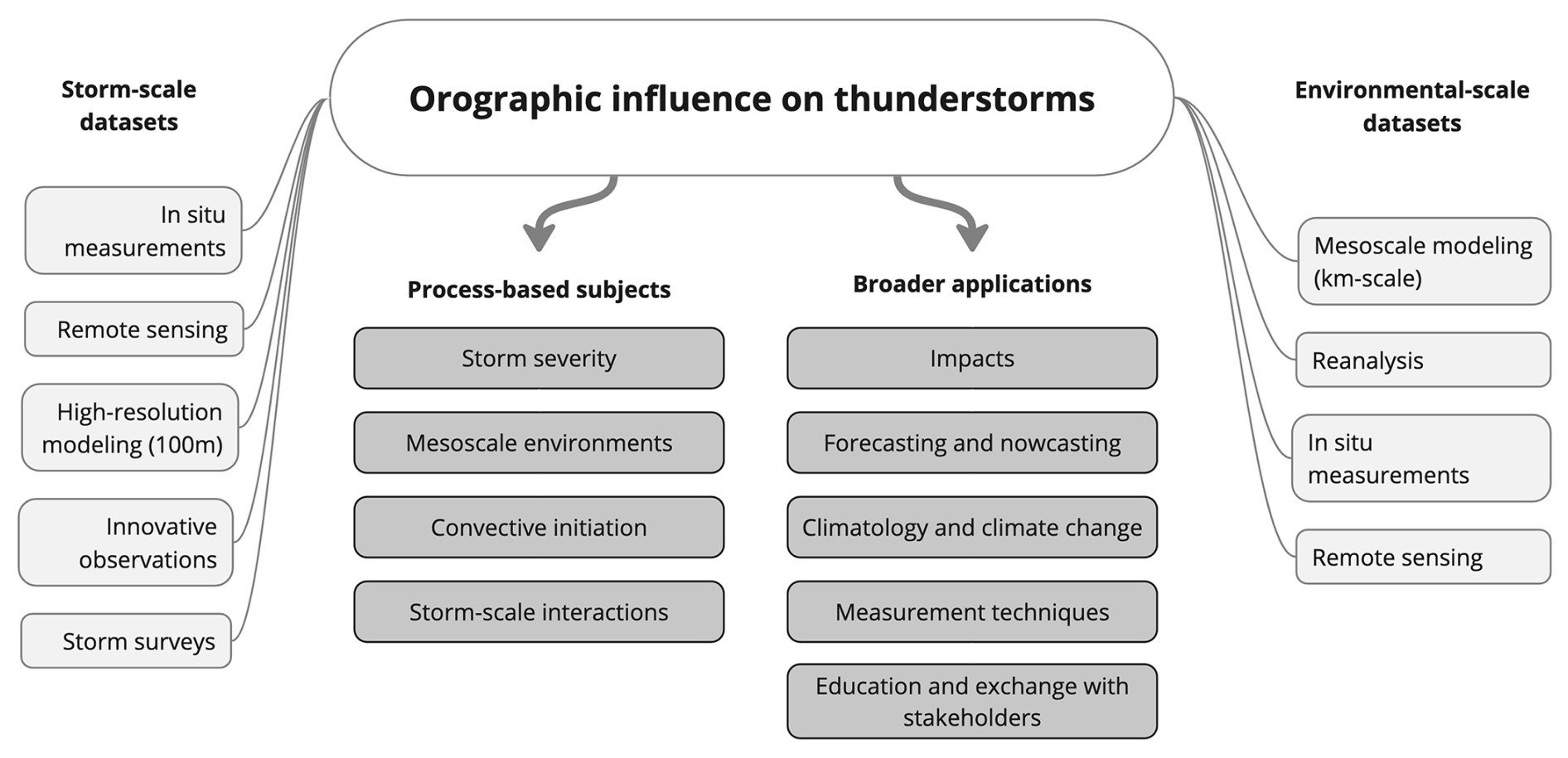
Figure 5Overview of the scopes of TIM research subjects (dark gray boxes) and the corresponding scales, methodologies, and datasets (light gray boxes).
3.1 Summary
As reviewed in Sect. 2 and based on our White Paper survey, a wide variety of research topics (RTs) exists regarding severe convective storms near mountains. Figure 5 provides an overview of these topics and highlights the methodologies and data sources involved. The key research questions can be summarized as follows.
- 1.
Why do severe-weather reports cluster near mountain ranges? To answer this, the terrain-induced perturbations of environmental parameters, like CAPE and wind shear, will need to be weighed against storm-scale processes and CI in different regions and scenarios (RTs 2.1, 2.2, 2.3, 2.4).
- 2.
What are the gaps in our understanding of the storm-internal processes leading to large hail, strong winds, lightning, tornadoes, and extreme precipitation, and how are these processes modulated by orography? Such a basic understanding is also essential to better anticipate the impact of global warming on severe storms (RTs 2.1, 2.4, 2.5, 2.7, 2.8).
- 3.
What are the strengths and limits of new observation techniques from satellites, radars, and drones? TIM will provide the unique opportunity to compare these datasets to high-resolution sampling of individual storms and heterogeneous environments near complex terrain (RTs 2.2, 2.4, 2.6, 2.8).
- 4.
What observations are most important to improve numerical weather prediction models and nowcasting? Higher-resolution datasets (than those currently operational) of the pre-storm environment and thunderstorm properties in TIM can be used in model studies to help answer this question and also to improve data assimilation and parameterizations of orographic or microphysical processes (RTs 2.1, 2.4, 2.6).
The importance of these research topics is emphasized by the observed increase in related losses in recent years and the projected increase in severe-storm activity because of climate change. ESSL is therefore coordinating plans for the TIM field campaign as a first-of-its-kind pan-European campaign on severe convective storms. These plans are currently being worked out in regular meetings with all partners. This White Paper may serve as a scientific basis for further planning of the campaign and the writing of funding proposals. Since the ultimate scope of TIM will depend on the success of these proposals and further planning, a detailed campaign plan cannot be presented here. However, to give readers an impression of how we envision TIM, the rest of this section briefly discusses the planned concept.
3.2 Preliminary TIM campaign rationale
Figure 6 provides an example overview of the data collection. The TIM campaign can profit from the wealth of already-operational observations across Europe (red text in Fig. 6). This includes meteorological stations with ground data, regular vertical soundings, radars, satellites, lightning sensors, and public reports. Some of these datasets are currently not openly available to researchers. One example is the European radar network, which is globally unique in its density and coverage and provides excellent opportunities for analysis over a large region but is often only analyzed for each country separately. Data sharing in TIM could therefore accelerate the development of new radar-based algorithms for severe-weather prediction based on machine learning (Leinonen et al., 2023; Forcadell et al., 2024). To this end, part of the funding will be allocated to create a central data hub for systematic data collection, exchange, and long-term archiving. Ideally, TIM will be a first step towards permanent sharing of operational datasets for SCS research in the future.
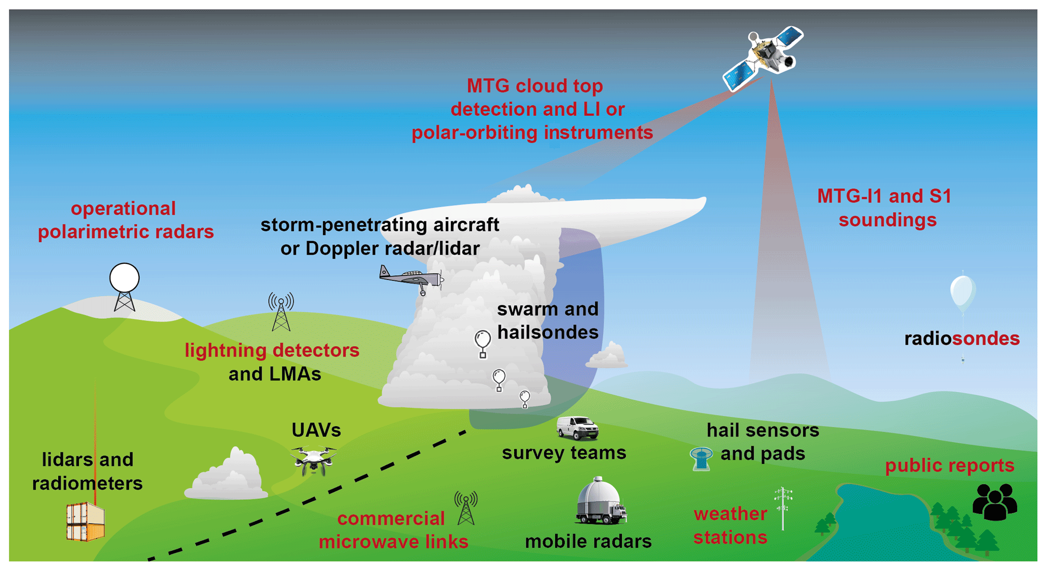
Figure 6Overview of the observations planned in TIM. Since the campaign is still in an early phase, this can be seen as an ideal or example setup. The red-colored text denotes at least partially operational data, while the black text denotes parts of the TIM operations.
However, additional data from the TIM campaign are needed, especially in and around thunderstorms and at higher spatial and temporal resolution than is currently provided by operational networks (black text in Fig. 6). This includes mobile radars, swarmsondes, drones, high-resolution soundings, and survey teams. Such observations are often difficult to obtain due to the fast-evolving and small-scale nature of convective storms. Thus, to sample a high number of cases, it is necessary to be mobile. On the other hand, some of the research objectives described herein require specific measurements which can only be supplied by fixed instruments, such as lidars, hail disdrometers, LMAs, or high-density station networks, which cannot be re-located on a daily basis (e.g., Emeis et al., 2018).
A field campaign with both mobile and fixed-site measurement strategies offers the unique opportunity to address this dilemma. To sample individual storms and their hazards, TIM will deploy several mobile teams to a region where high-impact storms are expected on a given day. Most severe-weather events cluster in time and space, so mobile teams can collect data in the same region over multiple days or by traveling from west to east with a conditionally unstable air mass. At the same time, multiple permanent TIM focus sites will be set up over the convective season to continuously monitor the same region, supplemented by the mobile teams when severe-storm activity is expected in the same location. A similar strategy has been successfully used in several campaigns focused on convective storms in target regions (e.g., PERILS, RELAMPAGO). A unique aspect of the current plans for TIM is that focus sites will be maintained by participating institutions based on their individual funding and research focus. In parallel, core funding of TIM will support mobile teams to collect additional high-resolution data. This flexible approach allows for the effective use of funds and overlap of different research topics (Fig. 5).
Figure 7 highlights potential regions of interest (ROIs), where ROIs are identified through clustering analyses of ESWD severe hail reports. This is one way to objectively define ROIs and is used as an example here to highlight the most important ROIs: the Po Valley and the border region between Austria and Slovenia south of the Alps; the valleys near the Swiss Jura, Black Forest, Swabian Jura, and southern Bavaria north of the Alps; and regions around the Pyrenees, Massif Central, Dinaric Alps, Bohemian Massif, and Carpathian Mountains. Many secondary ROIs are also visible in Fig. 7. It is important to note that ESWD reports can be subject to reporting biases, so some of these secondary ROIs in less populated regions, such as around the Carpathian Mountains, are likely more impacted by SCSs than depicted here (Šinger and Púčik, 2020). Nevertheless, the reports show good agreement with existing radar-based climatologies in Europe (e.g., Punge and Kunz, 2016; Fluck et al., 2021) and allow the identification of regions of high impact. Which focus sites can ultimately be investigated in depth with TIM will depend on the priorities and funding of individual partner institutions.
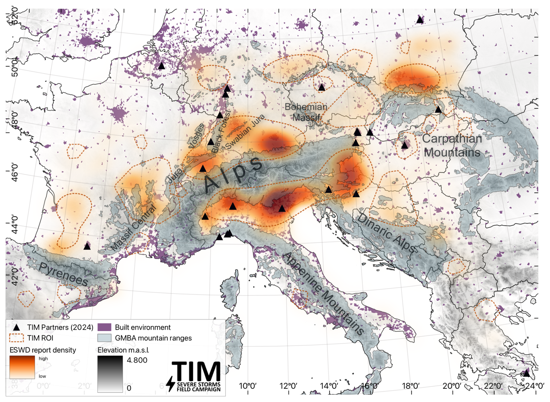
Figure 7Map of the TIM domain with regions of interest (ROIs). ROIs were identified based on in-domain ESWD severe hail reports (cf. Fig. 1). The red shading indicates primary hotspots with high report densities from kernel-density estimation (KDE). To represent secondary clusters, reports grouped by density-based spatial clustering of applications (DBSCANs) are indicated with the dashed red contours. Also shown are mountain ranges of the GMBA mountain inventory and built-up surfaces (Snethlage et al., 2022b, a). The black triangles show official TIM partner institutions' headquarter locations as of May 2025 (see list in the text). Publisher's remark: please note that the above figure contains disputed territories.
Besides the geographical and climatological differences among the regions, the densities, lengths, and types of operational observations also vary substantially. The collaboration between many institutes brings together the necessary expertise to handle these diverse data needs, which no single institution can cover on its own. TIM already has a long list of partner institutions officially engaged, who also contributed to this article (see “Team list” section and Fig. 7). A core investigative team, led by ESSL, will be established to lead these efforts and to ensure that possible conflicting interests over many institutions can be coordinated. Working groups on individual subtopics, such as climatology, radar, airborne data, and idealized cloud modeling, are currently being established and will be expanded to specify the plans for TIM. Because of the spectrum of topics and because of the high spatio-temporal variability of convective storms (e.g., Taszarek et al., 2020a), the campaign is planned for three consecutive convective storm seasons, currently from 2027 to 2029. This is followed by 2 years of data analysis to ensure the effective and coordinated use of the observations. These observational data will be supplemented by numerical modeling experiments tailored to the respective research questions and focus regions.
Furthermore, ESSL testbeds during and after the campaign provide ample opportunities to foster exchange with European severe-weather forecasters. High-quality forecasts focused on severe convective storms are also essential for the coordination of the campaign. Like in previous severe-storm campaigns, a forecast team will be responsible for briefing the research groups on an active campaign day. The forecasts can benefit from the bundled resources of partner institutions and experience of projects like the European Storm Forecast Experiment (ESTOFEX), Previsione Temporali (PRETEMP), and local forecast offices that know the characteristic meteorology of a certain mountain range.
Thanks to the globally connected severe-storm community, TIM can also profit from the experience of international researchers. For example, TIM researchers could coordinate with and learn from the ICECHIP and TEAMx campaigns (Adams-Selin et al., 2022; Rotach et al., 2022). Their research foci (hailstorms in the US Great Plains and terrain effects on the atmosphere) can be complemented and linked by TIM's focus on severe convection near mountains. Exchanges with the Northern Hail Project and Northern Tornadoes Project (e.g., Brimelow et al., 2023), the LIFT campaign (Kunz et al., 2024), and observational efforts by the Australian Bureau of Meteorology (e.g., Soderholm et al., 2025) are already ongoing. TIM has the ambition to foster collaboration with international researchers, stakeholders, and policymakers; educate through public and media outreach; and introduce students to the field of convective storms, which will ultimately help to meet the challenges that the increasing risk of SCSs poses to European society.
| CAPE | Convective available potential energy |
| CCN | Cloud condensation nuclei |
| CI | Convection initiation |
| CIN | Convective inhibition |
| CML | Commercial microwave link |
| ESSL | European Severe Storms Laboratory |
| IF | International Fujita (scale) |
| INP | Ice-nucleating particle |
| LMA | Lightning mapping array |
| MCS | Mesoscale convective system |
| MESH | Maximum estimated size of hail |
| POH | Probability of hail |
| QPE | Quantitative precipitation estimation |
| ROI | Region of interest |
| RT | Research topic |
| SCS | Severe convective storm |
| VIL | Vertical integrated liquid |
Severe weather reports are available from the European Severe Weather Database (2025) at https://eswd.eu/.
The TIM Partners, presented in alphabetical order, comprise the extended co-authors of this article:
Martin Adamovsky (Czech Hydrometeorological Institute (ČHMÚ), Prague, Czech Republic), Clotilde Augros (CNRM, Université de Toulouse, Météo-France, CNRS, Toulouse, France), Ulrich Blahak (Deutscher Wetterdienst (DWD), Offenbach, Germany), Vojtěch Bližňák (Czech Academy of Sciences – Institute of Atmospheric Physics (CAS UFA), Prague, Czech Republic), Stephan Bojinski (European Organisation for the Exploitation of Meteorological Satellites (EUMETSAT), Darmstadt, Germany), Tobias Bölle (Institut für Physik der Atmosphäre, Deutsches Zentrum für Luft- und Raumfahrt (DLR), Oberpfaffenhofen, Germany), François Bouttier (CNRM, Université de Toulouse, Météo-France, CNRS, Toulouse, France), Massimiliano Burlando (University of Genoa, Genoa, Italy), Xavier Calbet (Agencia Estatal de Meteorología (AEMET), Madrid, Spain), Federico Canepa (University of Genoa), Orietta Cazzuli (Regional Agency for Environmental Protection of Lombardia (ARPA Lombardia), Milano, Italy), Alessandro Ceppi (Department of Civil and Environmental Engineering (D.I.C.A.), Politecnico di Milano, Milan, Italy), Fleur Couvreux (CNRM, Université de Toulouse, Météo-France, CNRS, Toulouse, France), Kálmán Csirmaz (HungaroMet Hungarian Meteorological Service (HungaroMet), Budapest, Hungary), Tamás Csonka (HungaroMet Hungarian Meteorological Service (HungaroMet), Budapest, Hungary), Stavros Dafis (National Observatory of Athens – Institute for Environmental Research and Sustainable Development (NOA), Athens, Greece), Mária Derková (Slovak Hydrometeorological Institute (SHMÚ), Bratislava, Slovakia), Francesco Domenichini (Regional Agency for Environmental Protection and Prevention of the Veneto (ARPA Veneto), Padova, Italy, Grzegorz Duniec (Institute of Meteorology and Water Management – National Research Institute Poland (IMGW), Warsaw, Poland), Raquel Evaristo (University of Bonn, Bonn, Germany), Tomáš Fedor (Pavol Jozef Šafárik University (UPJS), Košice, Slovakia), Massimo Enrico Ferrario (Regional Agency for Environmental Protection and Prevention of the Veneto (ARPA Veneto), Padova, Italy), Michael Frech (CNRM, Université de Toulouse, Météo-France, CNRS, Toulouse, France), Enrico Gambini (Department of Civil and Environmental Engineering (D.I.C.A.), Politecnico di Milano, Milan, Italy), Jaroslav Hofierka (Pavol Jozef Šafárik University (UPJS), Košice, Slovakia), Ákos Horváth (HungaroMet Hungarian Meteorological Service (HungaroMet), Budapest, Hungary), Adam Jaczewski (Institute of Meteorology and Water Management – National Research Institute Poland (IMGW), Warsaw, Poland), Vinzent Klaus (Universität für Bodenkultur (BOKU), Vienna, Austria), Zsófia Kocsis (HungaroMet Hungarian Meteorological Service (HungaroMet), Budapest, Hungary), Kornél Komjáti (HungaroMet Hungarian Meteorological Service (HungaroMet), Budapest, Hungary), Michael Kunz (Karlsruhe Institute of Technology (KIT)), Máté Kurcsics (HungaroMet Hungarian Meteorological Service (HungaroMet), Budapest, Hungary), Robert Kvak (Czech Academy of Sciences – Institute of Atmospheric Physics (CAS UFA), Prague, Czech Republic), Konstantinos Lagouvardos (National Observatory of Athens – Institute for Environmental Research and Sustainable Development (NOA), Athens, Greece), Katharina Lengfeld (CNRM, Université de Toulouse, Météo-France, CNRS, Toulouse, France), Marco Mancini (Department of Civil and Environmental Engineering (D.I.C.A.), Politecnico di Milano, Milan, Italy), Marc Mandement (CNRM, Université de Toulouse, Météo-France, CNRS, Toulouse, France), Olivia Martius (University of Bern – Institute of Geography, Bern, Switzerland), Massimo Milelli (CIMA Research Foundation (CIMA), Savona, Italy), Gian Paolo Minardi (Regional Agency for Environmental Protection of Lombardia (ARPA Lombardia), Milano, Italy), Samuel Monhart (Federal Office of Meteorology and Climatology MeteoSwiss, Locarno-Monti, Switzerland), Antonio Parodi (CIMA Research Foundation (CIMA), Savona, Italy), Giovanni Ravazzani (Department of Civil and Environmental Engineering (D.I.C.A.), Politecnico di Milano, Milan, Italy), Ricardo Reinoso-Rondinel (KU Leuven, Department of Civil Engineering, Leuven, Belgium), Didier Ricard (CNRM, Université de Toulouse, Météo-France, CNRS, Toulouse, France), David Rýva (Czech Hydrometeorological Institute (ČHMÚ), Prague, Czech Republic), Tobias Scharbach (University of Bonn, Bonn, Germany), Stefano Serafin (University of Vienna, Department of Meteorology and Geophysics, Vienna, Austria), André Simon (Slovak Hydrometeorological Institute (SHMÚ), Bratislava, Slovakia), Miroslav Šinger (Slovak Hydrometeorological Institute (SHMÚ), Bratislava, Slovakia and Faculty of Mathematics Physics and Informatics, Comenius University, Bratislava, Slovakia), Zbyněk Sokol (Czech Academy of Sciences – Institute of Atmospheric Physics (CAS UFA), Prague, Czech Republic), Gabriella Szépszó (HungaroMet Hungarian Meteorological Service (HungaroMet), Budapest, Hungary), Silke Trömel (University of Bonn, Bonn, Germany), Barbara Turato (Regional Agency for Environmental Protection of Liguria (ARPA Liguria), Genova, Italy), Benoît Vié (CNRM, Université de Toulouse, Météo-France, CNRS, Toulouse, France), Clemens Wastl (Austrian Federal Institute for Geology, Geophysics, Climatology, and Meteorology (GeoSphereAustria, former ZAMG), Vienna, Austria), Christoph Wittmann (Austrian Federal Institute for Geology, Geophysics, Climatology, and Meteorology (GeoSphereAustria, former ZAMG), Vienna, Austria), Petr Zacharov (Czech Academy of Sciences – Institute of Atmospheric Physics (CAS UFA), Prague, Czech Republic), Matteo Zanetti (Regional Agency for Environmental Protection of Lombardia (ARPA Lombardia), Milano, Italy), Dino Zardi (University of Trento, Department of Civil Environmental and Mechanical Engineering (DICAM), Trento, Italy).
The first author (JF) oversaw and organized the writing and provided Figs. 2, 3, and 6. PG, AH, MF, KS, FB, LS, TP, CG, and BA contributed through writing tasks or figures. The extended co-authors (see list above) provided initial writing topics, including short paragraphs, which were incorporated into the article by the first author. All contributors proofread the manuscript draft and provided references and suggestions on specific topics.
The contact author has declared that none of the authors has any competing interests.
Publisher’s note: Copernicus Publications remains neutral with regard to jurisdictional claims made in the text, published maps, institutional affiliations, or any other geographical representation in this paper. While Copernicus Publications makes every effort to include appropriate place names, the final responsibility lies with the authors.
The two anonymous reviewers provided exceptionally detailed and helpful suggestions. Feedback on an early version of the manuscript by Rebecca Adams-Selin, Karen Kosiba, Matthew Kumjian, Kelly Lombardo, Paul Markowski, James Marquis, Stephen Nesbitt, Bruno Ribeiro, Joshua Soderholm, Jeff Trapp, and Joshua Wurman is greatly appreciated.
The following official partner institutions of the TIM campaign have signed letters of intent (as of May 2025):
Albert-Ludwigs-Universität Freiburg (University of Freiburg, Freiburg, Germany), Austro Control (AustroControl, Vienna, Austria), Državni hidrometeorološki zavod (DHMZ, Zagreb, Croatia), the Institute of Atmospheric Sciences and Climate (ISAC, Bologna, Italy), Consiglio Nazionale delle Ricerche (CNR, Rome, Italy), the Department of Civil Engineering of KU Leuven (Leuven, Belgium), and the Slovenian Environment Agency (ARSO, Ljubljana, Slovenia).
ESSL preparatory work for TIM is supported by the Provincial Government of Lower Austria Science Fund (grant no. K3-F-190/013-2023).
The article processing charges for this open-access publication were covered by the Karlsruhe Institute of Technology (KIT).
This paper was edited by Gregor C. Leckebusch and reviewed by two anonymous referees.
Adam, S., Behrendt, A., Schwitalla, T., Hammann, E., and Wulfmeyer, V.: First assimilation of temperature lidar data into an NWP model: impact on the simulation of the temperature field, inversion strength and PBL depth, Q. J. Roy. Meteor. Soc., 142, 2882–2896, https://doi.org/10.1002/qj.2875, 2016. a
Adams-Selin, R. D., Allen, J., Gensini, V., and Heymsfield, A.: ICECHIP: Closing Critical Observational Gaps in Hail Research, North American Hail Workshop, Boulder, Colorado, https://cpaess.ucar.edu/sites/default/files/2022-09/Hail-workshop-agendaV2.pdf (last access: 5 August 2025), 2022. a
Adler, B., Kalthoff, N., Kohler, M., Handwerker, J., Wieser, A., Corsmeier, U., Kottmeier, C., Lambert, D., and Bock, O.: The variability of water vapour and pre-convective conditions over the mountainous island of Corsica, Q. J. Roy. Meteor. Soc., 142, 335–346, https://doi.org/10.1002/qj.2545, 2016. a, b
Agard, V. and Emanuel, K.: Clausius–Clapeyron scaling of peak CAPE in continental convective storm environments, J. Atmos. Sci., 74, 3043–3054, https://doi.org/10.1175/JAS-D-16-0352.1, 2017. a
Allen, J. T., Giammanco, I. M., Kumjian, M. R., Jurgen Punge, H., Zhang, Q., Groenemeijer, P., Kunz, M., and Ortega, K.: Understanding Hail in the Earth System, Rev. Geophys., 58, e2019RG000665, https://doi.org/10.1029/2019RG000665, 2020. a, b
Antonescu, B., Schultz, D. M., Holzer, A., and Groenemeijer, P.: Tornadoes in Europe: An underestimated threat, B. Am. Meteorol. Soc., 98, 713–728, https://doi.org/10.1175/BAMS-D-16-0171.1, 2017. a
Aregger, M., Martius, O., Germann, U., and Hering, A.: Differential reflectivity columns and hail – linking C-band radar-based estimated column characteristics to crowdsourced hail observations in Switzerland, arXiv [preprint], 1–21, https://doi.org/10.48550/arXiv.2410.10499, 14 October 2024. a
Auf der Maur, A. and Germann, U.: A Re-Evaluation of the Swiss Hail Suppression Experiment Using Permutation Techniques Shows Enhancement of Hail Energies When Seeding, Atmosphere, 12, 1623, https://doi.org/10.3390/atmos12121623, 2021. a
Augenstein, M., Mohr, S., and Kunz, M.: Influence of the North Atlantic Oscillation on annual spatio-temporal lightning clusters in western and central Europe, EGUsphere [preprint], https://doi.org/10.5194/egusphere-2024-2804, 2024. a
Bachmann, K., Keil, C., Craig, G. C., Weissmann, M., and Welzbacher, C. A.: Predictability of deep convection in idealized and operational forecasts: Effects of radar data assimilation, orography, and synoptic weather regime, Mon. Weather Rev., 148, 63–81, https://doi.org/10.1175/MWR-D-19-0045.1, 2020. a, b, c
Bagaglini, L., Ingrosso, R., and Miglietta, M. M.: Synoptic patterns and mesoscale precursors of Italian tornadoes, Atmos. Res., 253, 105503, https://doi.org/10.1016/j.atmosres.2021.105503, 2021. a
Barthlott, C., Czajka, B., Kunz, M., Saathoff, H., Zhang, H., Böhmländer, A., Gasch, P., Handwerker, J., Kohler, M., Wilhelm, J., Wieser, A., and Hoose, C.: The impact of aerosols and model grid spacing on a supercell storm from Swabian MOSES 2021, Q. J. Roy. Meteor. Soc., 150, 2005–2027, https://doi.org/10.1002/qj.4687, 2024. a
Battaglioli, F., Groenemeijer, P., Púčik, T., Taszarek, M., Ulbrich, U., and Rust, H.: Modeled Multidecadal Trends of Lightning and (Very) Large Hail in Europe and North America (1950–2021), J. Appl. Meteorol. Clim., 62, 1627–1653, https://doi.org/10.1175/JAMC-D-22-0195.1, 2023. a, b, c
Bedka, K. M., Allen, J. T., Punge, H. J., Kunz, M., and Simanovic, D.: A long-term overshooting convective cloud-top detection database over Australia derived from MTSAT Japanese Advanced Meteorological Imager Observations, J. Appl. Meteorol. Clim., 57, 937–951, https://doi.org/10.1175/JAMC-D-17-0056.1, 2018. a
Benjamin, S. G., Dévényi, D., Weygandt, S. S., Brundage, K. J., Brown, J. M., Grell, G. A., Kim, D., Schwartz, B. E., Smirnova, T. G., Smith, T. L., and Manikin, G. S.: An hourly assimilation-forecast cycle: The RUC, Mon. Weather Rev., 132, 495–518, https://doi.org/10.1175/1520-0493(2004)132<0495:AHACTR>2.0.CO;2, 2004. a
Besic, N., Figueras i Ventura, J., Grazioli, J., Gabella, M., Germann, U., and Berne, A.: Hydrometeor classification through statistical clustering of polarimetric radar measurements: a semi-supervised approach, Atmos. Meas. Tech., 9, 4425–4445, https://doi.org/10.5194/amt-9-4425-2016, 2016. a
Blair, S. F., Deroche, D. R., Boustead, J. M., Leighton, J. W., Barjenbruch, B. L., and Gargan, W. P.: Radar-Based Assessment of the Detectability of Giant Hail, E-Journal of Severe Storms Meteorology, 6, 1–30, https://doi.org/10.55599/ejssm.v6i7.34, 2011. a
Blair, S. F., Laflin, J. M., Cavanaugh, D. E., Sanders, K. J., Currens, S. R., Pullin, J. I., Cooper, D. T., Deroche, D. R., Leighton, J. W., Fritchie, R. V., Mezeul, M. J., Goudeau, B. T., Kreller, S. J., Bosco, J. J., Kelly, C. M., and Mallinson, H. M.: High-resolution hail observations: Implications for NWS warning operations, Weather Forecast., 32, 1101–1119, https://doi.org/10.1175/WAF-D-16-0203.1, 2017. a
Bojinski, S., Blaauboer, D., Calbet, X., de Coning, E., Debie, F., Montmerle, T., Nietosvaara, V., Norman, K., Bañón Peregrín, L., Schmid, F., Strelec Mahović, N., and Wapler, K.: Towards nowcasting in Europe in 2030, Meteorol. Appl., 30, e2124, https://doi.org/10.1002/met.2124, 2023. a, b, c
Bosart, L. F., Seimon, A., LaPenta, K. D., and Dickinson, M. J.: Supercell tornadogenesis over complex terrain: The Great Barrington, Massachusetts, tornado on 29 May 1995, Weather Forecast., 21, 897–922, https://doi.org/10.1175/WAF957.1, 2006. a
Bougeault, P., Binder, P., Buzzi, A., Dirks, R., Houze, R., Kuettner, J., Smith, R. B., Steinacker, R., and Volkert, H.: The MAP Special Observing Period, B. Am. Meteorol. Soc., 82, 433–462, https://doi.org/10.1175/1520-0477(2001)082<0433:TMSOP>2.3.CO;2, 2001. a
Brennan, K. P. and Wilhelm, L.: Saharan dust linked to European hail events, EGUsphere [preprint], https://doi.org/10.5194/egusphere-2024-3924, 2024. a, b
Brennan, K. P., Thurnherr, I., Sprenger, M., and Wernli, H.: Insights from hailstorm track analysis in European climate change simulations, EGUsphere [preprint], https://doi.org/10.5194/egusphere-2025-918, 2025. a
Brimelow, J. C., Kopp, G. A., and Sills, D. M. L.: The Northern Hail Project: A renaissance in hail research in Canada, 11th European Conference on Severe Storms, Bucharest, Romania, 8–12 May 2023, ECSS2023-170, https://doi.org/10.5194/ecss2023-170, 2023. a, b
Brook, J. P., Protat, A., Soderholm, J., Carlin, J. T., McGowan, H., and Warren, R. A.: Hailtrack–improving radar-based hailfall estimates by modeling hail trajectories, J. Appl. Meteorol. Clim., 60, 237–254, https://doi.org/10.1175/JAMC-D-20-0087.1, 2021. a
Brooks, H. E., Doswell, C. A., Zhang, X., Chernokulsky, A. M. A., Tochimoto, E., Hanstrum, B., de Lima Nascimento, E., Sills, D. M. L., Antonescu, B., and Barrett, B.: A Century of Progress in Severe Convective Storm Research and Forecasting, Meteor. Mon., 59, 18.1–18.41, https://doi.org/10.1175/amsmonographs-d-18-0026.1, 2019. a
Brown, T. and Giammanco, I.: IBHS multi-faceted hail research program, RCI, 31, 5–8, 2013. a
Browning, K. A. and Foote, G. B.: Airflow and hail growth in supercell storms and some implications for hail suppression, Q. J. Roy. Meteor. Soc., 102, 499–533, https://doi.org/10.1002/qj.49710243303, 1976. a
Burlando, M., Miglietta, M. M., Avolio, E., Bechini, R., Cassola, F., De Martin, F., Lagasio, M., Milelli, M., Parodi, A., and Romanic, D.: The – WIND RISK project: nowcast and simulation of thunderstorm outflows, Bulletin of Atmospheric Science and Technology, 5, 1–10, https://doi.org/10.1007/s42865-024-00079-6, 2024. a
Calbet, X., Carbajal Henken, C., DeSouza-Machado, S., Sun, B., and Reale, T.: Horizontal small-scale variability of water vapor in the atmosphere: implications for intercomparison of data from different measuring systems, Atmos. Meas. Tech., 15, 7105–7118, https://doi.org/10.5194/amt-15-7105-2022, 2022. a
Calvin, K., Dasgupta, D., Krinner, G., Mukherji, A., Thorne, P. W., Trisos, C., Romero, J., Aldunce, P., Barrett, K., Blanco, G., Cheung, W. W. L., Connors, S., Denton, F., Diongue-Niang, A., Dodman, D., Garschagen, M., Geden, O., Hayward, B., Jones, C., Jotzo, F., Krug, T., Lasco, R., Lee, Y.-Y., Masson-Delmotte, V., Meinshausen, M., Mintenbeck, K., Mokssit, A., Otto, F. E. L., Pathak, M., Pirani, A., Poloczanska, E., Pörtner, H.-O., Revi, A., Roberts, D. C., Roy, J., Ruane, A. C., Skea, J., Shukla, P. R., Slade, R., Slangen, A., Sokona, Y., Sörensson, A. A., Tignor, M., van Vuuren, D., Wei, Y.-M., Winkler, H., Zhai, P., Zommers, Z., Hourcade, J.-C., Johnson, F. X., Pachauri, S., Simpson, N. P., Singh, C., Thomas, A., Totin, E., Alegría, A., Armour, K., Bednar-Friedl, B., Blok, K., Cissé, G., Dentener, F., Eriksen, S., Fischer, E., Garner, G., Guivarch, C., Haasnoot, M., Hansen, G., Hauser, M., Hawkins, E., Hermans, T., Kopp, R., Leprince-Ringuet, N., Lewis, J., Ley, D., Ludden, C., Niamir, L., Nicholls, Z., Some, S., Szopa, S., Trewin, B., van der Wijst, K.-I., Winter, G., Witting, M., Birt, A., and Ha, M.: IPCC, 2023: Climate Change 2023: Synthesis Report. Contribution of Working Groups I, II and III to the Sixth Assessment Report of the Intergovernmental Panel on Climate Change, edited by: Core Writing Team, Lee, H., and Romero, J., IPCC, Geneva, Switzerland, https://doi.org/10.59327/ipcc/ar6-9789291691647, 2023. a
Canepa, F., Burlando, M., and Solari, G.: Vertical profile characteristics of thunderstorm outflows, J. Wind Eng. Ind. Aerod., 206, 104332, https://doi.org/10.1016/j.jweia.2020.104332, 2020. a
Canepa, F., Romanic, D., Hangan, H., and Burlando, M.: Experimental translating downbursts immersed in the atmospheric boundary layer, J. Wind Eng. Ind. Aerod., 243, 105570, https://doi.org/10.1016/j.jweia.2023.105570, 2023. a
Carey, L. D. and Buffalo, K. M.: Environmental control of cloud-to-ground lightning polarity in severe storms, Mon. Weather Rev., 135, 1327–1353, https://doi.org/10.1175/MWR3361.1, 2007. a
Carey, L. D., Rutledge, S. A., and Petersen, W. A.: The relationship between severe storm reports and cloud-to-ground lightning polarity in the contiguous United States from 1989 to 1998, Mon. Weather Rev., 131, 1211–1228, https://doi.org/10.1175/1520-0493(2003)131<1211:TRBSSR>2.0.CO;2, 2003. a
Ceppi, A., Ravazzani, G., Salandin, A., Rabuffetti, D., Montani, A., Borgonovo, E., and Mancini, M.: Effects of temperature on flood forecasting: analysis of an operative case study in Alpine basins, Nat. Hazards Earth Syst. Sci., 13, 1051–1062, https://doi.org/10.5194/nhess-13-1051-2013, 2013. a, b
Chen, J., Dai, A., Zhang, Y., and Rasmussen, K. L.: Changes in convective available potential energy and convective inhibition under global warming, J. Climate, 33, 2025–2050, https://doi.org/10.1175/JCLI-D-19-0461.1, 2020. a
Chen, J. Y., Reinoso-Rondinel, R., Trömel, S., Simmer, C., and Ryzhkov, A.: A Radar-Based Quantitative Precipitation Estimation Algorithm to Overcome the Impact of Vertical Gradients of Warm-Rain Precipitation: The Flood in Western Germany on 14 July 2021, J. Hydrometeorol., 24, 521–536, https://doi.org/10.1175/JHM-D-22-0111.1, 2023. a, b
Chmielewski, V. C., Bruning, E. C., and Ancell, B. C.: Variations of Thunderstorm Charge Structures in West Texas on 4 June 2012, J. Geophys. Res.-Atmos., 123, 9502–9523, https://doi.org/10.1029/2018JD029006, 2018. a
Chow, F. K., Schär, C., Ban, N., Lundquist, K. A., Schlemmer, L., and Shi, X.: Crossing multiple gray zones in the transition from mesoscale to microscale simulation over complex terrain, Atmosphere, 10, 274, https://doi.org/10.3390/atmos10050274, 2019. a
Cummings, K. A., Pickering, K. E., Barth, M. C., Bela, M. M., Li, Y., Allen, D., Bruning, E., MacGorman, D. R., Ziegler, C. L., Biggerstaff, M. I., Fuchs, B., Davis, T., Carey, L., Mecikalski, R. M., and Finney, D. L.: Evaluation of Lightning Flash Rate Parameterizations in a Cloud-Resolved WRF-Chem Simulation of the 29–30 May 2012 Oklahoma Severe Supercell System Observed During DC3, J. Geophys. Res.-Atmos., 129, e2023JD039492, https://doi.org/10.1029/2023JD039492, 2024. a
Ćurić, M. and Janc, D.: Differential heating influence on hailstorm vortex pair evolution, Q. J. Roy. Meteor. Soc., 138, 72–80, https://doi.org/10.1002/qj.918, 2012. a
Ćurić, M., Janc, D., and Vučković, V.: Numerical simulation of Cb cloud vorticity, Atmos. Res., 83, 427–434, https://doi.org/10.1016/j.atmosres.2005.10.024, 2007. a
Dabernig, M., Mayr, G. J., Messner, J. W., and Zeileis, A.: Spatial ensemble post-processing with standardized anomalies, Q. J. Roy. Meteor. Soc., 143, 909–916, https://doi.org/10.1002/qj.2975, 2017. a
Dawson, D. T., Mansell, E. R., Jung, Y., Wicker, L. J., Kumjian, M. R., and Xue, M.: Low-level ZDR signatures in supercell forward flanks: The role of size sorting and melting of hail, J. Atmos. Sci., 71, 276–299, https://doi.org/10.1175/JAS-D-13-0118.1, 2014. a
De Martin, F., Davolio, S., Miglietta, M. M., and Levizzani, V.: A Conceptual Model for the Development of Tornadoes in the Complex Orography of the Po Valley, Mon. Weather Rev., 152, 1357–1377, https://doi.org/10.1175/MWR-D-23-0222.1, 2024. a, b, c, d
De Martin, F., Manzato, A., Carlon, N., Setvák, M., and Miglietta, M. M.: A dynamic and statistical analysis of giant hail environments in North-East Italy, Q. J. Roy. Meteor. Soc., e4945, https://doi.org/10.1002/qj.4945, 2025. a, b, c
Delobbe, L. and Holleman, I.: Uncertainties in radar echo top heights used for hail detection, Meteorol. Appl., 13, 361–374, https://doi.org/10.1017/S1350482706002374, 2006. a
Demortier, A., Mandement, M., Pourret, V., and Caumont, O.: Assimilation of surface pressure observations from personal weather stations in AROME-France, Nat. Hazards Earth Syst. Sci., 24, 907–927, https://doi.org/10.5194/nhess-24-907-2024, 2024. a
Doswell, C. A.: The Distinction between Large-Scale and Mesoscale Contribution to Severe Convection: A Case Study Example, Weather Forecast., 2, 3–16, https://doi.org/10.1175/1520-0434(1987)002<0003:TDBLSA>2.0.CO;2, 1987. a
Doswell, C. A., Brooks, H. E., and Maddox, R. A.: Flash Flood Forecasting: An Ingredients-Based Methodology, Weather Forecast., 11, 560–581, 1996. a, b
Dotzek, N.: Tornadoes in Germany, Atmos. Res., 56, 233–251, https://doi.org/10.1016/S0169-8095(00)00075-2, 2001. a, b
Dotzek, N., Groenemeijer, P., Feuerstein, B., and Holzer, A. M.: Overview of ESSL's severe convective storms research using the European Severe Weather Database ESWD, Atmos. Res., 93, 575–586, https://doi.org/10.1016/j.atmosres.2008.10.020, 2009. a
Ducrocq, V., Davolio, S., Ferretti, R., Flamant, C., Santaner, V. H., Kalthoff, N., Richard, E., and Wernli, H.: Introduction to the HyMeX Special Issue on 'Advances in understanding and forecasting of heavy precipitation in the Mediterranean through the HyMeX SOP1 field campaign', Q. J. Roy. Meteor. Soc., 142, 1–6, https://doi.org/10.1002/qj.2856, 2016. a
Durran, D. R. and Weyn, J. A.: Thunderstorms do not get butterflies, B. Am. Meteorol. Soc., 97, 237–243, https://doi.org/10.1175/BAMS-D-15-00070.1, 2016. a
ECMWF: Destination Earth (DestinE), https://digital-strategy.ec.europa.eu/en/policies/destination-earth (last access: 10/ March 2025), 2023. a
Eirund, G. K., Drossaart van Dusseldorp, S., Brem, B. T., Dedekind, Z., Karrer, Y., Stoll, M., and Lohmann, U.: Aerosol–cloud–precipitation interactions during a Saharan dust event – A summertime case-study from the Alps, Q. J. Roy. Meteor. Soc., 148, 943–961, https://doi.org/10.1002/qj.4240, 2022. a
Emeis, S., Kalthoff, N., Adler, B., Pardyjak, E., Paci, A., and Junkermann, W.: High-resolution observations of transport and exchange processes in mountainous terrain, Atmosphere, 9, 457, https://doi.org/10.3390/atmos9120457, 2018. a
Erdmann, F. and Poelman, D. R.: Insights into thunderstorm characteristics from geostationary lightning jump and dive observations, Nat. Hazards Earth Syst. Sci., 25, 1751–1768, https://doi.org/10.5194/nhess-25-1751-2025, 2025. a
ESSL: International Fujita (IF) Scale, https://www.essl.org/cms/research-projects/international-fujita-scale/ (last access: 10 March 2025), 2023a. a
ESSL: Severe Weather Surveys and Survey Guide, http://essl.org/cms/publications/detailed-survey-reports/ (last access: 10 March 2025), 2023b. a
ESSL: ESSL news: Hail record broken again – 19cm hailstone confirmed in Italy, https://www.essl.org/cms/hail-record-broken-again-19cm-hailstone-confirmed-in-italy/ (last access: 10 March 2025), 2023c. a
European Severe Weather Database (ESWD): https://eswd.eu/, last access: 10 March 2025. a
Evaristo, R., Reinoso-Rondinel, R., Tromel, S., and Simmer, C.: Validation of Wind Fields Retrieved by Dual-Doppler Techniques Using a Vertically Pointing Radar, in: 2021 21st International Radar Symposium (IRS), Berlin, Germany, 21–22 June 2021, IEEE, 1–7, https://doi.org/10.23919/IRS51887.2021.9466173, 2021. a
Feldmann, M., Germann, U., Gabella, M., and Berne, A.: A characterisation of Alpine mesocyclone occurrence, Weather Clim. Dynam., 2, 1225–1244, https://doi.org/10.5194/wcd-2-1225-2021, 2021. a
Feldmann, M., Hering, A., Gabella, M., and Berne, A.: Hailstorms and rainstorms versus supercells – a regional analysis of convective storm types in the Alpine region, npj Climate and Atmospheric Science, 6, 1–11, https://doi.org/10.1038/s41612-023-00352-z, 2023. a, b, c, d
Feldmann, M., Rotunno, R., Germann, U., and Berne, A.: Supercell Thunderstorms in Complex Topography – How Mountain Valleys with Lakes Can Increase Occurrence Frequency, Mon. Weather Rev., 152, 471–489, https://doi.org/10.1175/MWR-D-22-0350.1, 2024. a, b, c, d, e, f, g
Feldmann, M., Blanc, M., Brennan, K. P., Thurnherr, I., Velasquez, P., Martius, O., and Schär, C.: European supercell thunderstorms – an underestimated current threat and an increasing future hazard, arXiv [preprint], https://doi.org/10.48550/arXiv.2503.07466, 10 March 2025. a
Fencl, M., Dohnal, M., and Bareš, V.: Retrieving Water Vapor From an E-Band Microwave Link With an Empirical Model Not Requiring In Situ Calibration, Earth and Space Science, 8, e2021EA001911, https://doi.org/10.1029/2021EA001911, 2021. a
Figueras i Ventura, J., Pineda, N., Besic, N., Grazioli, J., Hering, A., van der Velde, O. A., Romero, D., Sunjerga, A., Mostajabi, A., Azadifar, M., Rubinstein, M., Montanyà, J., Germann, U., and Rachidi, F.: Analysis of the lightning production of convective cells, Atmos. Meas. Tech., 12, 5573–5591, https://doi.org/10.5194/amt-12-5573-2019, 2019. a
Fluck, E., Kunz, M., Geissbuehler, P., and Ritz, S. P.: Radar-based assessment of hail frequency in Europe, Nat. Hazards Earth Syst. Sci., 21, 683–701, https://doi.org/10.5194/nhess-21-683-2021, 2021. a, b
Forcadell, V., Augros, C., Caumont, O., Dedieu, K., Ouradou, M., David, C., Figueras i Ventura, J., Laurantin, O., and Al-Sakka, H.: Severe-hail detection with C-band dual-polarisation radars using convolutional neural networks, Atmos. Meas. Tech., 17, 6707–6734, https://doi.org/10.5194/amt-17-6707-2024, 2024. a
Fourrié, N., Nuret, M., Brousseau, P., and Caumont, O.: Data assimilation impact studies with the AROME-WMED reanalysis of the first special observation period of the Hydrological cycle in the Mediterranean Experiment, Nat. Hazards Earth Syst. Sci., 21, 463–480, https://doi.org/10.5194/nhess-21-463-2021, 2021. a
Frame, J. W. and Markowski, P.: The interaction of simulated squall lines with idealized mountain ridges, Mon. Weather Rev., 134, 1919–1941, https://doi.org/10.1175/MWR3157.1, 2006. a
French, M. M. and Kingfield, D. M.: Tornado Formation and Intensity Prediction Using Polarimetric Radar Estimates of Updraft Area, Weather Forecast., 36, 2211–2231, https://doi.org/10.1175/WAF-D-21-0087.1, 2021. a
Fuchs, B. R., Rutledge, S. A., Bruning, E. C., Pierce, J. R., Kodros, J. K., Lang, T. J., MacGorman, D. R., Krehbiel, P. R., and Rison, W.: Environmental controls on storm intensity and charge structure in multiple regions of the continental United States, J. Geophys. Res., 120, 6575–6596, https://doi.org/10.1002/2015JD023271, 2015. a
Fujita, T.: Mesoanalysis of the Illinois Tornadoes of April 1953, J. Atmos. Sci., 15, 288–296, https://doi.org/10.1175/1520-0469(1958)015<0288:MOTITO>2.0.CO;2, 1958. a
Fujita, T.: Downbursts: meteorological features and wind field characteristics, J. Wind Eng. Ind. Aerod., 36, 75–86, https://doi.org/10.1016/0167-6105(90)90294-M, 1990. a
Fujita, T. T.: The Teton-Yellowstone Tornado of 21 July 1987, Mon. Weather Rev., 117, 1913–1940, https://doi.org/10.1175/1520-0493(1989)117<1913:TTYTOJ>2.0.CO;2, 1989. a
Gallo, K., Schumacher, P., Boustead, J., and Ferguson, A.: Validation of satellite observations of storm damage to cropland with digital photographs, Weather Forecast., 34, 435–446, https://doi.org/10.1175/WAF-D-18-0059.1, 2019. a
Gatzen, C. P., Fink, A. H., Schultz, D. M., and Pinto, J. G.: An 18-year climatology of derechos in Germany, Nat. Hazards Earth Syst. Sci., 20, 1335–1351, https://doi.org/10.5194/nhess-20-1335-2020, 2020. a
Geerts, B., Andretta, T., Luberda, S. J., Vogt, J., Wang, Y., Oolman, L. D., Bikos, D., and Finch, J.: Case Study of a Long-lived Tornadic Mesocyclone in a Low-CAPE Complex-terrain Environment, E-Journal of Severe Storms Meteorology, 4, 1–29, https://doi.org/10.55599/ejssm.v4i3.20, 2009. a
Geerts, B., Parsons, D., Zieglgler, C. L., Weckwerth, T. M., Biggggerstaff, M. I., Clark, R. D., Coniglglio, M. C., Demoz, B. B., Ferrare, R. A., Gallus, W. A., Haghi, K., Hanesiak, J. M., Klein, P. M., Knupp, K. R., Kosiba, K., McFarquhar, G. M., Moore, J. A., Nehrir, A. R., Parker, M. D., Pinto, J. O., Rauber, R. M., Schumacher, R. S., Turner, D. D., Wang, Q., Wang, X., Wang, Z., and Wurman, J.: The 2015 plains elevated convection at night field project, B. Am. Meteorol. Soc., 98, 767–786, https://doi.org/10.1175/BAMS-D-15-00257.1, 2017. a
Gensini, V. A., Ashley, W. S., Michaelis, A. C., Haberlie, A. M., Goodin, J., and Wallace, B. C.: Hailstone size dichotomy in a warming climate, npj Climate and Atmospheric Science, 7, 1–10, https://doi.org/10.1038/s41612-024-00728-9, 2024. a
Germann, U., Boscacci, M., Clementi, L., Gabella, M., Hering, A., Sartori, M., Sideris, I. V., and Calpini, B.: Weather Radar in Complex Orography, Remote Sensing, 14, 503, https://doi.org/10.3390/rs14030503, 2022. a
Ghasemifard, H., Groenemeijer, P., Battaglioli, F., and Púčik, T.: Do changing circulation types raise the frequency of summertime thunderstorms and large hail in Europe?, Environmental Research: Climate, 3, 015008, https://doi.org/10.1088/2752-5295/ad22ec, 2024. a
Giordani, A., Kunz, M., Bedka, K. M., Punge, H. J., Paccagnella, T., Pavan, V., Cerenzia, I. M. L., and Di Sabatino, S.: Characterizing hail-prone environments using convection-permitting reanalysis and overshooting top detections over south-central Europe, Nat. Hazards Earth Syst. Sci., 24, 2331–2357, https://doi.org/10.5194/nhess-24-2331-2024, 2024. a
Göbel, M., Serafin, S., and Rotach, M. W.: Adverse impact of terrain steepness on thermally driven initiation of orographic convection, Weather Clim. Dynam., 4, 725–745, https://doi.org/10.5194/wcd-4-725-2023, 2023. a, b
Goger, B., Rotach, M. W., Gohm, A., Stiperski, I., Fuhrer, O., and De Morsier, G.: A new horizontal length scale for a three-dimensional turbulence parameterization in mesoscale atmospheric modeling over highly complex terrain, J. Appl. Meteorol. Clim., 58, 2087–2102, https://doi.org/10.1175/JAMC-D-18-0328.1, 2019. a
Gopalakrishnan, D., Cuervo-Lopez, C., Allen, J. T., Trapp, R. J., and Robinson, E.: A Comprehensive Evaluation of Biases in Convective Storm Parameters in CMIP6 Models over North America, J. Climate, 38, 947–971, https://doi.org/10.1175/JCLI-D-24-0165.1, 2025. a
Greene, D. R. and Clark, R. A.: Vertically Integrated Liquid Water—A New Analysis Tool, Mon. Weather Rev., 100, 548–552, https://doi.org/10.1175/1520-0493(1972)100<0548:VILWNA>2.3.CO;2, 1972. a
Groenemeijer, P.: Evaluating IASI Profiles at the ESSL Test-bed and for Selected Cases, https://www.eumetrain.org/index.php/resources/evaluating-iasi-profiles-essl-test-bed-and-selected-cases (last access: 10 March 2025), 2019. a
Guay, B., Fengler, M., and Hammerschmidt, L.: Improving Nowcasts and Forecasts via Operational Use of Meteomatics Meteodrones, EGU General Assembly 2023, Vienna, Austria, 24–28 Apr 2023, EGU23-8632, https://doi.org/10.5194/egusphere-egu23-8632, 2023. a
Gustafsson, N., Janjić, T., Schraff, C., Leuenberger, D., Weissmann, M., Reich, H., Brousseau, P., Montmerle, T., Wattrelot, E., Bučánek, A., Mile, M., Hamdi, R., Lindskog, M., Barkmeijer, J., Dahlbom, M., Macpherson, B., Ballard, S., Inverarity, G., Carley, J., Alexander, C., Dowell, D., Liu, S., Ikuta, Y., and Fujita, T.: Survey of data assimilation methods for convective-scale numerical weather prediction at operational centres, Q. J. Roy. Meteor. Soc., 144, 1218–1256, https://doi.org/10.1002/qj.3179, 2018. a, b
Hannesen, R., Dotzek, N., Gysi, H., and Beheng, K. D.: Case study of a tornado in the Upper Rhine valley, Meteorol. Z., 7, 163–170, https://doi.org/10.1127/metz/7/1998/163, 1998. a
Hervo, M., Romanens, G., Martucci, G., Weusthoff, T., and Haefele, A.: Evaluation of an Automatic Meteorological Drone Based on a 6-Month Measurement Campaign, Atmosphere, 14, 1382, https://doi.org/10.3390/atmos14091382, 2023. a
Heymsfield, A. J., Cecchini, M. A., Detwiler, A., Honeyager, R., and Field, P.: Exploring the Composited T-28 Hailstorm Penetration Dataset to Characterize Hail Properties within the Updraft and Downdraft Regions, J. Appl. Meteorol. Clim., 62, 1803–1826, https://doi.org/10.1175/JAMC-D-23-0030.1, 2023. a, b
Holmlund, K., Grandell, J., Schmetz, J., Stuhlmann, R., Bojkov, B., Munro, R., Lekouara, M., Coppens, D., Viticchie, B., August, T., Theodore, B., Watts, P., Dobber, M., Fowler, G., Bojinski, S., Schmid, A., Salonen, K., Tjemkes, S., Aminou, D., and Blythe, P.: Meteosat Third Generation (MTG): Continuation and Innovation of Observations from Geostationary Orbit, B. Am. Meteorol. Soc., 102, E990–E1015, https://doi.org/10.1175/BAMS-D-19-0304.1, 2021. a
Homeyer, C. R., McAuliffe, J. D., and Bedka, K. M.: On the development of above-anvil cirrus plumes in extratropical convection, J. Atmos. Sci., 74, 1617–1633, https://doi.org/10.1175/JAS-D-16-0269.1, 2017. a
Houston, A. L., Argrow, B., Coniglio, M., Frew, E. W., Rasmussen, E. N., Weiss, C. C., and Ziegler, C. L.: Targeted Observation by Radars and UAS of Supercells (TORUS): Summary of the 2019 Field Campaign, in: 110th AMS Annual Meeting, 12–16 January 2020, Boston, MA, USA, 2020. a
Houze Jr., R. A.: Orographic effects on precipitating clouds, Rev. Geophys., 50, 1–47, https://doi.org/10.1029/2011RG000365, 2012. a, b
Houze Jr., R. A., Schmid, W., Fovell, R. G., and Schiesser, H.-H.: Hailstorms in Switzerland: Left Movers, Right Movers, and False Hooks, Mon. Weather Rev., 121, 3345–3370, https://doi.org/10.1175/1520-0493(1993)121<3345:HISLMR>2.0.CO;2, 1993. a
Imamovic, A., Schlemmer, L., and Schär, C.: Mountain volume control on deep-convective rain amount during episodes of weak synoptic forcing, J. Atmos. Sci., 76, 605–626, https://doi.org/10.1175/JAS-D-18-0217.1, 2019. a
Jensen, M. P., Flynn, J. H., Judd, L. M., Kollias, P., Kuang, C., McFarquhar, G., Nadkarni, R., Powers, H., and Sullivan, J.: A Succession of Cloud, Precipitation, Aerosol, and Air Quality Field Experiments in the Coastal Urban Environment, B. Am. Meteorol. Soc., 102, 103–105, https://doi.org/10.1175/BAMS-D-21-0104.1, 2022. a, b
Kahraman, A., Kendon, E. J., Chan, S. C., and Fowler, H. J.: Quasi-Stationary Intense Rainstorms Spread Across Europe Under Climate Change, Geophys. Res. Lett., 48, e2020GL092361, https://doi.org/10.1029/2020GL092361, 2021. a, b
Kahraman, A., Kendon, E. J., and Fowler, H. J.: Climatology of severe hail potential in Europe based on a convection-permitting simulation, Clim. Dynam., 62, 6625–6642, https://doi.org/10.1007/s00382-024-07227-w, 2024. a
Kaltenboeck, R. and Steinheimer, M.: Radar-based severe storm climatology for Austrian complex orography related to vertical wind shear and atmospheric instability, Atmos. Res., 158–159, 216–230, https://doi.org/10.1016/j.atmosres.2014.08.006, 2015. a, b
Katona, B. and Markowski, P.: Assessing the influence of complex terrain on severe convective environments in Northeastern Alabama, Weather Forecast., 36, 1003–1029, https://doi.org/10.1175/WAF-D-20-0136.1, 2021. a, b, c, d
Katona, B., Markowski, P., Alexander, C., and Benjamin, S.: The influence of topography on convective storm environments in the eastern United States as deduced from the HRRR, Weather Forecast., 31, 1481–1490, https://doi.org/10.1175/WAF-D-16-0038.1, 2016. a
Kaňák, J., Benko, M., Simon, A., and Sokol, A.: Case study of the 9 May 2003 windstorm in southwestern Slovakia, Atmos. Res., 83, 162–175, https://doi.org/10.1016/j.atmosres.2005.09.012, 2007. a
Khodayar, S., Davolio, S., Di Girolamo, P., Lebeaupin Brossier, C., Khodayar, S., Davolio, S., Di Girolamo, P., Lebeaupin Brossier, C., Flaounas, E., Fourrie, N., Lee, K.-O., Ricard, D., Vie, B., Bouttier, F., Caldas-Alvarez, A., and Ducrocq, V.: Overview towards improved understanding of the mechanisms leading to heavy precipitation in the western Mediterranean: lessons learned from HyMeX, Atmos. Chem. Phys., 21, 17051–17078, https://doi.org/10.5194/acp-21-17051-2021, 2021. a
Kirshbaum, D. J.: Numerical simulations of orographic convection across multiple gray zones, J. Atmos. Sci., 77, 3301–3320, https://doi.org/10.1175/JAS-D-20-0035.1, 2020. a
Kirshbaum, D. J., Adler, B., Kalthoff, N., Barthlott, C., and Serafin, S.: Moist orographic convection: Physical mechanisms and links to surface-exchange processes, Atmosphere, 9, 1–26, https://doi.org/10.3390/atmos9030080, 2018. a, b, c, d, e
Klaus, V. and Krause, J.: Investigating Hailstorm Updrafts and Nowcasting Hail Size Using a Novel Radar-Based Updraft Detection, Weather Forecast., 39, 1795–1815, https://doi.org/10.1175/WAF-D-23-0227.1, 2024. a
Klaus, V., Rieder, H., and Kaltenböck, R.: Insights in Hailstorm Dynamics through Polarimetric High-Resolution X-Band and Operational C-Band Radar: A Case Study for Vienna, Austria, Mon. Weather Rev., 151, 913–929, https://doi.org/10.1175/MWR-D-22-0185.1, 2023. a
Knight, C. A., Foote, G. B., and Summers, P. W.: Results of a Randomized Hail Suppression Experiment in Northeast Colorado. Part IX: Overall Discussion and Summary in the Context of Physical Research, J. Appl. Meteorol. Clim., 18, 1629–1639, https://doi.org/10.1175/1520-0450(1979)018<1629:ROARHS>2.0.CO;2, 1979. a
Kollias, P., McFarquhar, G. M., Bruning, E., DeMott, P. J., Kumjian, M. R., Lawson, P., Lebo, Z., Logan, T., Lombardo, K., Oue, M., Roberts, G., Shaw, R. A., van den Heever, S. C., Wolde, M., Barry, K. R., Bodine, D., Bruintjes, R., Chandrasekar, V., Dzambo, A., Hill, T. C. J., Jensen, M., Junyent, F., Kreidenweis, S. M., Lamer, K., Luke, E., Bansemer, A., McCluskey, C., Nichman, L., Nguyen, C., Patnaude, R. J., Perkins, R. J., Powers, H., Ranjbar, K., Roux, E., Snyder, J., Treserras, B. P., Tsai, P., Wales, N. A., Wolff, C., Allwayin, N., Ascher, B., Barr, J., Hu, Y., Huang, Y., Litzmann, M., Mages, Z., McKeown, K., Patil, S., Rosky, E., Tuftedal, K., Tzeng, M.-D., and Zhu, Z.: Experiment of Sea Breeze Convection, Aerosols, Precipitation and Environment (ESCAPE), B. Am. Meteorol. Soc., 106, 310–332, https://doi.org/10.1175/bams-d-23-0014.1, 2024. a
Komjáti, K., Csirmaz, K., Breuer, H., Kurcsics, M., and Horváth, Á.: Supercell interactions with surface baroclinic zones in the Carpathian Basin, 11th European Conference on Severe Storms, Bucharest, Romania, 8–12 May 2023, ECSS2023-39, https://doi.org/10.5194/ecss2023-39, 2023. a
Kopp, J., Schröer, K., Schwierz, C., Hering, A., Germann, U., and Martius, O.: The summer 2021 Switzerland hailstorms: weather situation, major impacts and unique observational data, Weather, 78, 184–191, https://doi.org/10.1002/wea.4306, 2023. a
Kosiba, K. A., Lyza, A. W., Trapp, R. J., Rasmussen, E. N., Parker, M., Biggerstaff, M. I., Nesbitt, S. W., Weiss, C. C., Wurman, J., Knupp, K. R., Coffer, B., Chmielewski, V. C., Dawson, D. T., Bruning, E., Bell, T. M., Coniglio, M. C., Murphy, T. A., French, M., Blind-Doskocil, L., Reinhart, A. E., dward Wolff, Schneider, M. E., Silcott, M., Smith, E., Aikins, J., Wagner, M., Robinson, P., Wilczak, J. M., White, T., Bodine, D., Kumjian, M. R., Waugh, S. M., Alford, A. A., Elmore, K., Kollias, P., and Turner, D. D.: The Propagation, Evolution, and Rotation in Linear Storms (PERiLS) Project, B. Am. Meteorol. Soc., 105, E1768–E1799, https://doi.org/10.1175/BAMS-D-22-0064.1, 2024. a
Kramer, M., Heinzeller, D., Hartmann, H., van den Berg, W., and Steeneveld, G. J.: Assessment of MPAS variable resolution simulations in the grey-zone of convection against WRF model results and observations: An MPAS feasibility study of three extreme weather events in Europe, Clim. Dynam., 55, 253–276, https://doi.org/10.1007/s00382-018-4562-z, 2020. a
Kumjian, M.: Principles and applications of dual-polarization weather radar. Part III: Artifacts, Journal of Operational Meteorology, 1, 265–274, https://doi.org/10.15191/nwajom.2013.0121, 2013. a
Kumjian, M. R. and Ryzhkov, A. V.: Polarimetric signatures in supercell thunderstorms, J. Appl. Meteorol. Clim., 47, 1940–1961, https://doi.org/10.1175/2007JAMC1874.1, 2008. a, b
Kumjian, M. R. and Ryzkhov, A. V.: Storm-relative helicity revealed from polarimetric radar measurements, J. Atmos. Sci., 66, 667–685, https://doi.org/10.1175/2008JAS2815.1, 2009. a
Kunkel, J., Hanesiak, J., and Sills, D.: The Hunt for Missing Tornadoes: Using Satellite Imagery to Detect and Document Historical Tornado Damage in Canadian Forests, J. Appl. Meteorol. Clim., 62, 139–154, https://doi.org/10.1175/JAMC-D-22-0070.1, 2023. a
Kunz, M. and Pusskeiler, M.: High-resolution assessment of the hail hazard over complex terrain from radar and insurance data, Open Access Article, 19, 427–439, https://doi.org/10.1127/0941-2948/2010/0452, 2010. a
Kunz, M., Blahak, U., Handwerker, J., Schmidberger, M., Punge, H. J., Mohr, S., Fluck, E., and Bedka, K. M.: The severe hailstorm in southwest Germany on 28 July 2013: characteristics, impacts and meteorological conditions, Q. J. Roy. Meteor. Soc., 144, 231–250, https://doi.org/10.1002/qj.3197, 2018. a, b
Kunz, M., Abbas, S. S., Bauckholt, M., Böhmländer, A., Feuerle, T., Gasch, P., Glaser, C., Groß, J., Hajnsek, I., Handwerker, J., Hase, F., Khordakova, D., Knippertz, P., Kohler, M., Lange, D., Latt, M., Laube, J., Martin, L., Mauder, M., Möhler, O., Mohr, S., Reitter, R. W., Rettenmeier, A., Rolf, C., Saathoff, H., Schrön, M., Schütze, C., Spahr, S., Späth, F., Vogel, F., Völksch, I., Weber, U., Wieser, A., Wilhelm, J., Zhang, H., and Dietrich, P.: Swabian MOSES 2021: An interdisciplinary field campaign for investigating convective storms and their event chains, Frontiers in Earth Science, 10, 1–26, https://doi.org/10.3389/feart.2022.999593, 2022. a, b
Kunz, M., Hühn, E., Fischer, J., Mohr, S., Latt, M., Trömel, S., and Soderholm, J.: Enhancing insights into large hail formation and trajectories through targeted field campaigns, in: 4th European Hail Workshop, Karlsruhe Institute of Technology, 5–7 March 2024, Karlsruhe, Germany, 2024. a, b
Kvak, R., Okon, L., Bližňák, V., Méri, L., and Kašpar, M.: Spatial distribution and precipitation intensity of supercells: Response to terrain asymmetry in the Western Carpathians, Central Europe, Atmos. Res., 292, 106885, https://doi.org/10.1016/j.atmosres.2023.106885, 2023. a, b
Labriola, J., Snook, N., Jung, Y., and Xue, M.: Explicit ensemble prediction of hail in 19 May 2013 Oklahoma city thunderstorms and analysis of hail growth processes with several multimoment microphysics schemes, Mon. Weather Rev., 147, 1193–1213, https://doi.org/10.1175/MWR-D-18-0266.1, 2019. a
Lainer, M., Brennan, K. P., Hering, A., Kopp, J., Monhart, S., Wolfensberger, D., and Germann, U.: Drone-based photogrammetry combined with deep learning to estimate hail size distributions and melting of hail on the ground, Atmos. Meas. Tech., 17, 2539–2557, https://doi.org/10.5194/amt-17-2539-2024, 2024. a
Laiti, L., Zardi, D., de Franceschi, M., Rampanelli, G., and Giovannini, L.: Analysis of the diurnal development of a lake-valley circulation in the Alps based on airborne and surface measurements, Atmos. Chem. Phys., 14, 9771–9786, https://doi.org/10.5194/acp-14-9771-2014, 2014. a
Lakshmi, K. K. A., Sahoo, S., Biswas, S. K., and Chandrasekar, V.: Study of Microphysical Signatures Based on Spectral Polarimetry during the RELAMPAGO Field Experiment in Argentina, J. Atmos. Ocean. Tech., 41, 235–260, https://doi.org/10.1175/JTECH-D-22-0113.1, 2024. a
Lasher-Trapp, S., Orendorf, S. A., and Trapp, R. J.: Investigating a Derecho in a Future Warmer Climate, B. Am. Meteorol. Soc., 104, E1831–E1852, https://doi.org/10.1175/BAMS-D-22-0173.1, 2023. a
LeBel, L. J., Tang, B. H., and Lazear, R. A.: Examining Terrain Effects on an Upstate New York Tornado Event Utilizing a High-Resolution Model Simulation, Weather Forecast., 36, 2001–2020, https://doi.org/10.1175/WAF-D-21-0018.1, 2021. a
Leinonen, J., Hamann, U., Sideris, I. V., and Germann, U.: Thunderstorm Nowcasting With Deep Learning: A Multi-Hazard Data Fusion Model, Geophys. Res. Lett., 50, e2022GL101626, https://doi.org/10.1029/2022GL101626, 2023. a, b
Lenderink, G., Ban, N., Brisson, E., Berthou, S., Cortés-Hernández, V. E., Kendon, E., Fowler, H. J., and de Vries, H.: Are dependencies of extreme rainfall on humidity more reliable in convection-permitting climate models?, Hydrol. Earth Syst. Sci., 29, 1201–1220, https://doi.org/10.5194/hess-29-1201-2025, 2025. a
Letkewicz, C. E. and Parker, M. D.: Impact of environmental variations on simulated squall lines interacting with terrain, Mon. Weather Rev., 139, 3163–3183, https://doi.org/10.1175/2011MWR3635.1, 2011. a
Lin, Y. and Kumjian, M. R.: Influences of CAPE on Hail Production in Simulated Supercell Storms, J. Atmos. Sci., 79, 179–204, https://doi.org/10.1175/JAS-D-21-0054.1, 2022. a
Liu, J. and Niyogi, D.: Meta-analysis of urbanization impact on rainfall modification, Scientific Reports, 9, 1–14, https://doi.org/10.1038/s41598-019-42494-2, 2019. a
Loeffler, S. D., Kumjian, M. R., Jurewicz, M., and French, M. M.: Differentiating Between Tornadic and Nontornadic Supercells Using Polarimetric Radar Signatures of Hydrometeor Size Sorting, Geophys. Res. Lett., 47, e2020GL088242, https://doi.org/10.1029/2020GL088242, 2020. a
Loftus, A. M. and Cotton, W. R.: Examination of CCN impacts on hail in a simulated supercell storm with triple-moment hail bulk microphysics, Atmos. Res., 147–148, 183–204, https://doi.org/10.1016/j.atmosres.2014.04.017, 2014. a
Lombardo, K. and Bitting, M.: A Climatology of Convective Precipitation over Europe, Mon. Weather Rev., 152, 1555–1585,https://doi.org/10.1175/MWR-D-23-0156.1, 2024. a
Lombardo, K. and Kumjian, M. R.: Observations of the Discrete Propagation of a Mesoscale Convective System during RELAMPAGO–CACTI, Mon. Weather Rev., 150, 2111–2138, https://doi.org/10.1175/MWR-D-21-0265.1, 2022. a
Maddox, R. A., Hoxit, L. R., and Chappell, C. F. : A Study of Tornadic Thunderstorm Interactions with Thermal Boundaries, Mon. Weather Rev., 108, 322–336, https://doi.org/10.1175/1520-0493(1980)108<0322:ASOTTI>2.0.CO;2, 1980. a, b
Malečić, B., Telišman Prtenjak, M., Horvath, K., Jelić, D., Mikuš Jurković, P., Ćorko, K., and Mahović, N. S.: Performance of HAILCAST and the Lightning Potential Index in simulating hailstorms in Croatia in a mesoscale model – Sensitivity to the PBL and microphysics parameterization schemes, Atmos. Res., 272, 106143, https://doi.org/10.1016/j.atmosres.2022.106143, 2022. a
Mandement, M. and Caumont, O.: A numerical study to investigate the roles of former Hurricane Leslie, orography and evaporative cooling in the 2018 Aude heavy-precipitation event, Weather Clim. Dynam., 2, 795–818, https://doi.org/10.5194/wcd-2-795-2021, 2021. a
Manzato, A., Cicogna, A., Centore, M., Battistutta, P., and Trevisan, M.: Hailstone Characteristics in Northeast Italy from 29 Years of Hailpad Data, J. Appl. Meteorol. Clim., 61, 1773–1789, https://doi.org/10.1175/JAMC-D-21-0251.1, 2022a. a, b
Manzato, A., Serafin, S., Miglietta, M. M., Kirshbaum, D., and Schulz, W.: A Pan-Alpine Climatology of Lightning and Convective Initiation, Mon. Weather Rev., 150, 2213–2230, https://doi.org/10.1175/MWR-D-21-0149.1, 2022b. a, b, c, d, e, f
Markowski, P. and Richardson, Y.: Mesoscale meteorology in midlatitudes, Vol. 2, John Wiley and Sons, https://doi.org/10.1002/9780470682104, 2010. a, b
Markowski, P. M. and Dotzek, N.: A numerical study of the effects of orography on supercells, Atmos. Res., 100, 457–478, https://doi.org/10.1016/j.atmosres.2010.12.027, 2011. a, b, c
Markowski, P. M., Richardson, Y. P., Richardson, S. J., and Petersson, A.: Aboveground thermodynamic observations in convective storms from balloonborne probes acting as pseudo-lagrangian drifters, B. Am. Meteorol. Soc., 99, 711–724, https://doi.org/10.1175/BAMS-D-17-0204.1, 2018. a
Marquis, J. N., Varble, A. C., Robinson, P., Nelson, T. C., and Friedrich, K.: Low-Level Mesoscale and Cloud-Scale Interactions Promoting Deep Convection Initiation, Mon. Weather Rev., 149, 2473–2495, https://doi.org/10.1175/MWR-D-20-0391.1, 2021. a, b
Marquis, J. N., Feng, Z., Varble, A., Nelson, T. C., Houston, A., Peters, J. M., Mulholland, J. P., and Hardin, J.: Near-Cloud Atmospheric Ingredients for Deep Convection Initiation, Mon. Weather Rev., 151, 1247–1267, https://doi.org/10.1175/MWR-D-22-0243.1, 2023. a
Martín, M. L., Calvo-Sancho, C., Taszarek, M., González-Alemán, J. J., Montoro-Mendoza, A., Díaz-Fernández, J., Bolgiani, P., Sastre, M., and Martín, Y.: Major Role of Marine Heatwave and Anthropogenic Climate Change on a Giant Hail Event in Spain, Geophys. Res. Lett., 51, e2023GL107632, https://doi.org/10.1029/2023GL107632, 2024. a
Marvi, M. T.: A review of flood damage analysis for a building structure and contents, Nat. Hazards, 102, 967–995, https://doi.org/10.1007/s11069-020-03941-w, 2020. a
McGinley, J.: A Diagnosis of Alpine Lee Cyclogenesis, Mon. Weather Rev., 110, 1271–1287, https://doi.org/10.1175/1520-0493(1982)110<1271:ADOALC>2.0.CO;2, 1982. a
McKeown, K. E., Davenport, C. E., Eastin, M. D., Purpura, S. M., and Riggin, R. R.: Radar Characteristics of Supercell Thunderstorms Traversing the Appalachian Mountains, Weather Forecast., 39, 639–654, https://doi.org/10.1175/waf-d-23-0110.1, 2024. a, b
Medina, B. L., Carey, L. D., Lang, T. J., Bitzer, P. M., Deierling, W., and Zhu, Y.: Characterizing Charge Structure in Central Argentina Thunderstorms During RELAMPAGO Utilizing a New Charge Layer Polarity Identification Method, Earth and Space Science, 8, e2021EA001803, https://doi.org/10.1029/2021EA001803, 2021. a
Merz, R., Tarasova, L., and Basso, S.: The flood cooking book: Ingredients and regional flavors of floods across Germany, Environ. Res. Lett., 15, 114024, https://doi.org/10.1088/1748-9326/abb9dd, 2020. a
Miglietta, M. M. and Rotunno, R.: Numerical simulations of sheared conditionally unstable flows over a mountain ridge, J. Atmos. Sci., 71, 1747–1762, https://doi.org/10.1175/JAS-D-13-0297.1, 2014. a
Miller, P. W. and Mote, T. L.: Standardizing the definition of a “pulse” thunderstorm, B. Am. Meteorol. Soc., 98, 905–913, https://doi.org/10.1175/BAMS-D-16-0064.1, 2017. a
Miyoshi, T., Kunii, M., Ruiz, J., Lien, G. Y., Satoh, S., Ushio, T., Bessho, K., Seko, H., Tomita, H., and Ishikawa, Y.: Big data assimilation revolutionizing severe weather prediction, B. Am. Meteorol. Soc., 97, 1347–1354, https://doi.org/10.1175/BAMS-D-15-00144.1, 2016. a
Mohr, S. and Kunz, M.: Recent trends and variabilities of convective parameters relevant for hail events in Germany and Europe, Atmos. Res., 123, 211–228, https://doi.org/10.1016/j.atmosres.2012.05.016, 2013. a
Mohr, S., Kunz, M., and Keuler, K.: Development and application of a logistic model to estimate the past and future hail potential in Germany, J. Geophys. Res.-Atmos., 120, 3939–3956, https://doi.org/10.1002/2014JD022959, 2015. a
Mohr, S., Wilhelm, J., Wandel, J., Kunz, M., Portmann, R., Punge, H. J., Schmidberger, M., Quinting, J. F., and Grams, C. M.: The role of large-scale dynamics in an exceptional sequence of severe thunderstorms in Europe May–June 2018, Weather Clim. Dynam., 1, 325–348, https://doi.org/10.5194/wcd-1-325-2020, 2020. a
Morgan Jr., G. M. and Towery, N. G.: On the Role of Strong Winds in Damage to Crops by Hail and Its Estimation with a Simple Instrument, Journal of Applied Meteorology (1962–1982), 15, 891–898, http://www.jstor.org/stable/26177518 (last access: 12 March 2025), 1976. a
Morrison, H., Lier‐Walqui, M., Fridlind, A. M., Grabowski, W. W., Harrington, J. Y., Hoose, C., Korolev, A., Kumjian, M. R., Milbrandt, J. A., Pawlowska, H., Posselt, D. J., Prat, O. P., Reimel, K. J., Shima, S., Diedenhoven, B., and Xue, L.: Confronting the challenge of modeling cloud and precipitation microphysics, J. Adv. Model. Earth Sy., 12, e2019MS001689, https://doi.org/10.1029/2019MS001689, 2020. a, b
Mulholland, J. P., Nesbitt, S. W., and Trapp, R. J.: A case study of terrain influences on upscale convective growth of a supercell, Mon. Weather Rev., 147, 4305–4324, https://doi.org/10.1175/MWR-D-19-0099.1, 2019. a
Mulholland, J. P., Nesbitt, S. W., Trapp, R. J., and Peters, J. M.: The influence of terrain on the convective environment and associated convective morphology from an idealized modeling perspective, J. Atmos. Sci., 77, 3929–3949, https://doi.org/10.1175/JAS-D-19-0190.1, 2020. a, b
Murillo, E. M. and Homeyer, C. R.: Severe hail fall and hailstorm detection using remote sensing observations, J. Appl. Meteorol. Clim., 58, 947–970, https://doi.org/10.1175/JAMC-D-18-0247.1, 2019. a
Murillo, E. M. and Homeyer, C. R.: What Determines Above-Anvil Cirrus Plume Infrared Temperature?, J. Atmos. Sci., 79, 3181–3194, https://doi.org/10.1175/JAS-D-22-0080.1, 2022. a
Nelson, T. C., Marquis, J., Varble, A., and Friedrich, K.: Radiosonde observations of environments supporting deep moist convection initiation during RELAMPAGO-CACTI, Mon. Weather Rev., 149, 289–309, https://doi.org/10.1175/MWR-D-20-0148.1, 2021. a
Nelson, T. C., Marquis, J., Peters, J. M., and Friedrich, K.: Environmental controls on simulated deep moist convection initiation occurring during RELAMPAGO-CACTI, J. Atmos. Sci., 79, 1941–1964, https://doi.org/10.1175/JAS-D-21-0226.1, 2022. a, b
Nesbitt, S. W., Salio, P. V., Ávila, E., Bitzer, P., Carey, L., Chandrasekar, V., Deierling, W., Dominguez, F., Dillon, M. E., Garcia, C. M., Gochis, D., Goodman, S., Hence, D. A., Kosiba, K. A., Kumjian, M. R., Lang, T., Luna, L. M., Marquis, J., Marshall, R., McMurdie, L. A., de Lima Nascimento, E., Rasmussen, K. L., Roberts, R., Rowe, A. K., Ruiz, J. J., São Sabbas, E. F., Saulo, A. C., Schumacher, R. S., Skabar, Y. G., Machado, L. A. T., Trapp, R. J., Varble, A. C., Wilson, J., Wurman, J., Zipser, E. J., Arias, I., Bechis, H., and Grover, M. A.: A storm safari in subtropical South America: Proyecto RELAMPAGO, B. Am. Meteorol. Soc., 102, E1621–E1644, https://doi.org/10.1175/BAMS-D-20-0029.1, 2021. a, b
Nisi, L., Hering, A., Germann, U., and Martius, O.: A 15-year hail streak climatology for the Alpine region, Q. J. Roy. Meteor. Soc., 144, 1429–1449, https://doi.org/10.1002/qj.3286, 2018. a, b, c, d
Nixon, C. J. and Allen, J. T.: Distinguishing between Hodographs of Severe Hail and Tornadoes, Weather Forecast, 37, 1761–1782, https://doi.org/10.1175/WAF-D-21-0136.1, 2022. a
Niyogi, D., Holt, T., Zhong, S., Pyle, P. C., and Basara, J.: Urban and land surface effects on the 30 July 2003 mesoscale convective system event observed in the southern Great Plains, J. Geophys. Res.-Atmos., 111, D19107, https://doi.org/10.1029/2005JD006746, 2006. a
Nomokonova, T., Griewank, P. J., Löhnert, U., Miyoshi, T., Necker, T., and Weissmann, M.: Estimating the benefit of Doppler wind lidars for short-term low-level wind ensemble forecasts, Q. J. Roy. Meteor. Soc., 149, 192–210, https://doi.org/10.1002/qj.4402, 2023. a
O'Neill, M. E., Orf, L., Heymsfield, G. M., and Halbert, K.: Hydraulic jump dynamics above supercell thunderstorms, Science, 373, 1248–1251, https://doi.org/10.1126/science.abh3857, 2021. a
Pacey, G., Pfahl, S., Schielicke, L., and Wapler, K.: The climatology and nature of warm-season convective cells in cold-frontal environments over Germany, Nat. Hazards Earth Syst. Sci., 23, 3703–3721, https://doi.org/10.5194/nhess-23-3703-2023, 2023. a, b
Pacey, G. P., Schultz, D. M., and Garcia-Carreras, L.: Severe Convective Windstorms in Europe: Climatology, Preconvective Environments, and Convective Mode, Weather Forecast., 36, 237–252, https://doi.org/10.1175/WAF-D-20-0075.1, 2021. a
Panosetti, D., Böing, S., Schlemmer, L., and Schmidli, J.: Idealized large-eddy and convection-resolving simulations of moist convection over mountainous terrain, J. Atmos. Sci., 73, 4021–4041, https://doi.org/10.1175/JAS-D-15-0341.1, 2016. a, b
Panziera, L., James, C. N., and Germann, U.: Mesoscale organization and structure of orographic precipitation producing flash floods in the lago maggiore region, Q. J. Roy. Meteor. Soc., 141, 224–248, https://doi.org/10.1002/qj.2351, 2015. a
Peters, J. M., Nowotarski, C. J., Mulholland, J. P., and Thompson, R. L.: The influences of effective inflow layer streamwise vorticity and storm-relative flow on supercell updraft properties, J. Atmos. Sci., 77, 3033–3057, https://doi.org/10.1175/JAS-D-19-0355.1, 2020. a
Peters, J. M., Chavas, D. R., Lebo, Z. J., and Su, C.-Y.: Cumulonimbus clouds convert a smaller fraction of CAPE into kinetic energy in a warmer atmosphere, J. Atmos. Sci., 81, 1943–1961, https://doi.org/10.1175/jas-d-24-0006.1, 2024. a
Pistotnik, G., Holzer, A. M., Kaltenböck, R., and Tschannett, S.: An F3 downburst in Austria-A case study with special focus on the importance of real-time site surveys, Atmos. Res., 100, 565–579, https://doi.org/10.1016/j.atmosres.2010.10.011, 2011. a
Pounds, L. E., Ziegler, C. L., Adams-Selin, R. D., and Biggerstaff, M. I.: Analysis of Hail Production via Simulated Hailstone Trajectories in the 29 May 2012 Kingfisher, Oklahoma, Supercell, Mon. Weather Rev., 152, 245–276, https://doi.org/10.1175/MWR-D-23-0073.1, 2024. a
Pruppacher, H. R. and Klett, J. D.: Microphysics of Clouds and Precipitation, Atmospheric and Oceanographic Sciences Library, Springer Netherlands, ISBN 9780306481000, https://books.google.de/books?id=0MURkyjuoGMC (last access: 12 March 2025), 2010. a
Púčik, T., Groenemeijer, P., Rýva, D., and Kolář, M.: Proximity soundings of severe and nonsevere thunderstorms in central Europe, Mon. Weather Rev., 143, 4805–4821, https://doi.org/10.1175/MWR-D-15-0104.1, 2015. a
Púčik, T., Groenemeijer, P., Rädler, A. T., Tijssen, L., Nikulin, G., Prein, A. F., van Meijgaard, E., Fealy, R., Jacob, D., and Teichmann, C.: Future changes in European severe convection environments in a regional climate model ensemble, J. Climate, 30, 6771–6794, https://doi.org/10.1175/JCLI-D-16-0777.1, 2017. a, b
Púčik, T., Castellano, C., Groenemeijer, P., Kühne, T., Rädler, A. T., Antonescu, B., and Faust, E.: Large hail incidence and its economic and societal impacts across Europe, Mon. Weather Rev., 147, 3901–3916, https://doi.org/10.1175/MWR-D-19-0204.1, 2019. a
Pucillo, A., Miglietta, M. M., Lombardo, K., and Manzato, A.: Application of a simple analytical model to severe winds produced by a bow echo like storm in northeast Italy, Meteorol. Appl., 27, 1–18, https://doi.org/10.1002/met.1868, 2019. a
Punge, H. J. and Kunz, M.: Hail observations and hailstorm characteristics in Europe: A review, Atmos. Res., 176–177, 159–184, https://doi.org/10.1016/j.atmosres.2016.02.012, 2016. a, b
Punge, H. J., Bedka, K. M., Kunz, M., and Reinbold, A.: Hail frequency estimation across Europe based on a combination of overshooting top detections and the ERA-INTERIM reanalysis, Atmos. Res., 198, 34–43, https://doi.org/10.1016/j.atmosres.2017.07.025, 2017. a, b
Rädler, A. T., Groenemeijer, P. H., Faust, E., Sausen, R., and Púčik, T.: Frequency of severe thunderstorms across Europe expected to increase in the 21st century due to rising instability, npj Climate and Atmospheric Science, 2, 3–7, https://doi.org/10.1038/s41612-019-0083-7, 2019. a, b
Rasmussen, E. N., Straka, J. M., Davies-Jones, R., Doswell, C. A., Carr, F. H., Eilts, M. D., and MacGorman, D. R.: Verification of the Origins of Rotation in Tornadoes Experiment: VORTEX, B. Am. Meteorol. Soc., 75, 995–1006, https://doi.org/10.1175/1520-0477(1994)075<0995:VOTOOR>2.0.CO;2, 1994. a
Raupach, T. H., Martius, O., Allen, J. T., Kunz, M., Trapp, S. L., Mohr, S., Rasmussen, K. L., and Trapp, R. J.: The effects of climate change on hailstorms, Nature Reviews Earth & Environment, 2, 213–226, https://doi.org/10.1038/s43017-020-00133-9, 2021. a
Ravazzani, G., Amengual, A., Ceppi, A., Homar, V., Romero, R., Lombardi, G., and Mancini, M.: Potentialities of ensemble strategies for flood forecasting over the Milano urban area, J. Hydrol., 539, 237–253, https://doi.org/10.1016/j.jhydrol.2016.05.023, 2016. a
Reeves, H. D. and Lin, Y. L.: The effects of a mountain on the propagation of a preexisting convective system for blocked and unblocked flow regimes, J. Atmos. Sci., 64, 2401–2421, https://doi.org/10.1175/JAS3959.1, 2007. a
Ringhausen, J., Chmielewski, V., and Calhoun, K.: Inter-Comparison of Lightning Measurements in Quasi-Linear Convective Systems, Atmosphere, 15, 309, https://doi.org/10.3390/atmos15030309, 2024. a
Ripberger, J. T., Krocak, M. J., Wehde, W. W., Allan, J. N., Silva, C., and Jenkins-Smith, H.: Measuring tornado warning reception, comprehension, and response in the United States, Weather Clim. Soc., 11, 863–880, https://doi.org/10.1175/WCAS-D-19-0015.1, 2019. a
Rombeek, N., Leinonen, J., and Hamann, U.: Exploiting radar polarimetry for nowcasting thunderstorm hazards using deep learning, Nat. Hazards Earth Syst. Sci., 24, 133–144, https://doi.org/10.5194/nhess-24-133-2024, 2024. a
Romps, D. M.: Clausius-clapeyron scaling of CAPE from analytical solutions to RCE, J. Atmos. Sci., 73, 3719–3737, https://doi.org/10.1175/JAS-D-15-0327.1, 2016. a
Rotach, M. W., Serafin, S., Ward, H. C., Arpagaus, M., Colfescu, I., Cuxart, J., De Wekker, S. F., Grubišic, V., Kalthoff, N., Karl, T., Kirshbaum, D. J., Lehner, M., Mobbs, S., Paci, A., Palazzi, E., Bailey, A., Schmidli, J., Wittmann, C., Wohlfahrt, G., and Zardi, D.: A Collaborative Effort to Better Understand, Measure, and Model Atmospheric Exchange Processes over Mountains, B. Am. Meteorol. Soc., 103, E1282–E1295, https://doi.org/10.1175/BAMS-D-21-0232.1, 2022. a, b, c, d, e, f, g
Rotunno, R. and Houze, R. A.: Lessons on orographic precipitation from the Mesoscale Alpine Programme, Q. J. Roy. Meteor. Soc., 133, 811–830, https://doi.org/10.1002/qj.67, 2007. a
Rotunno, R. and Klemp, J. B.: On the rotation and propagation of simulated supercell thunderstorms, J. Atmos. Sci., 42, 271–292, https://doi.org/10.1175/1520-0469(1985)042<0271:OTRAPO>2.0.CO;2, 1985. a
Rudlosky, S. D., Goodman, S. J., and Virts, K. S.: Chapter 16 – Lightning Detection: GOES-R Series Geostationary Lightning Mapper, in: The GOES-R Series, edited by: Goodman, S. J., Schmit, T. J., Daniels, J., and Redmon, R. J., Elsevier, 193–202, https://doi.org/10.1016/B978-0-12-814327-8.00016-0, ISBN 978-0-12-814327-8, 2020. a
Ryzhkov, A., Zhang, P., Bukovčić, P., Zhang, J., and Cocks, S.: Polarimetric Radar Quantitative Precipitation Estimation, Remote Sensing, 14, 1695, https://doi.org/10.3390/rs14071695, 2022. a
Saharia, M., Kirstetter, P. E., Vergara, H., Gourley, J. J., and Hong, Y.: Characterization of floods in the United States, J. Hydrol., 548, 524–535, https://doi.org/10.1016/j.jhydrol.2017.03.010, 2017. a, b
Saltikoff, E., Haase, G., Delobbe, L., Gaussiat, N., Martet, M., Idziorek, D., Leijnse, H., Novák, P., Lukach, M., and Stephan, K.: OPERA the radar project, Atmosphere, 10, 1–13, https://doi.org/10.3390/atmos10060320, 2019. a
Scarino, B., Itterly, K., Bedka, K., Homeyer, C. R., Allen, J., Bang, S., and Cecil, D.: Deriving Severe Hail Likelihood from Satellite Observations and Model Reanalysis Parameters Using a Deep Neural Network, Artificial Intelligence for the Earth Systems, 2, 1–30, https://doi.org/10.1175/aies-d-22-0042.1, 2023. a
Scheffknecht, P., Serafin, S., and Grubišić, V.: A long-lived supercell over mountainous terrain, Q. J. Roy. Meteor. Soc., 143, 2973–2986, https://doi.org/10.1002/qj.3127, 2017. a, b, c, d, e
Schmid, T., Portmann, R., Villiger, L., Schröer, K., and Bresch, D. N.: An open-source radar-based hail damage model for buildings and cars, Nat. Hazards Earth Syst. Sci., 24, 847–872, https://doi.org/10.5194/nhess-24-847-2024, 2024. a
Schmidli, J.: Daytime heat transfer processes over mountainous terrain, J. Atmos. Sci., 70, 4041–4066, https://doi.org/10.1175/JAS-D-13-083.1, 2013. a
Schmidt, M. L.: Improvement of hail detection and nowcasting by synergistic combination of information from polarimetric radar, model predictions, and in situ observations, PhD thesis, Rheinische Friedrich-Wilhelms-Universität Bonn, https://hdl.handle.net/20.500.11811/8701 (last access: 12 March 2025), 2020. a
Schultz, C. J., Carey, L. D., Schultz, E. V., and Blakeslee, R. J.: Insight into the kinematic and microphysical processes that control lightning jumps, Weather Forecast., 30, 1591–1621, https://doi.org/10.1175/WAF-D-14-00147.1, 2015. a
Schwartz, C. S. and Sobash, R. A.: Generating probabilistic forecasts from convection-allowing ensembles using neighborhood approaches: A review and recommendations, Mon. Weather Rev., 145, 3397–3418, https://doi.org/10.1175/MWR-D-16-0400.1, 2017. a
Seifert, A., Bachmann, V., Filipitsch, F., Förstner, J., Grams, C. M., Hoshyaripour, G. A., Quinting, J., Rohde, A., Vogel, H., Wagner, A., and Vogel, B.: Aerosol–cloud–radiation interaction during Saharan dust episodes: the dusty cirrus puzzle, Atmos. Chem. Phys., 23, 6409–6430, https://doi.org/10.5194/acp-23-6409-2023, 2023. a, b
Serafin, S., Rotach, M. W., Arpagaus, M., Colfescu, I., Cuxart, J., De Wekker, S. F. J., Evans, M., Grubišić, V., Kalthoff, N., Karl, T., Kirshbaum, D. J., Lehner, M., Mobbs, S., Paci, A., Palazzi, E., Raudzens Bailey, A., Schmidli, J., Wohlfahrt, G., and Zardi, D.: Multi-scale transport and exchange processes in the atmosphere over mountains, Innsbruck University Press, 42 pp., ISBN 978-3-99106-003-1, https://doi.org/10.15203/99106-003-1, 2020. a, b
Serafin, S., Schmidli, J., Goger, B., Ban, N., Westerhuis, S., Kotlarski, S., and Arpagaus, M.: TEAMx Numerical Modeling Plan, https://www.teamx-programme.org/modelling-activities/ (last access: 12 March 2025), 2024. a
Sessa, M. F. and Trapp, R. J.: Observed relationship between tornado intensity and pretornadic mesocyclone characteristics, Weather Forecast., 35, 1243–1261, https://doi.org/10.1175/WAF-D-19-0099.1, 2020. a
Sgoff, C., Acevedo, W., Paschalidi, Z., Ulbrich, S., Bauernschubert, E., Kratzsch, T., and Potthast, R.: Assimilation of crowd-sourced surface observations over Germany in a regional weather prediction system, Q. J. Roy. Meteor. Soc., 148, 1752–1767, https://doi.org/10.1002/qj.4276, 2022. a
Shikhov, A. and Chernokulsky, A.: A satellite-derived climatology of unreported tornadoes in forested regions of northeast Europe, Remote Sens. Environ., 204, 553–567, https://doi.org/10.1016/j.rse.2017.10.002, 2018. a
Šinger, M. and Púčik, T.: A challenging tornado forecast in Slovakia, Atmosphere, 11, 821, https://doi.org/10.3390/ATMOS11080821, 2020. a, b
Smith, B. T., Thompson, R. L., Grams, J. S., Broyles, C., and Brooks, H. E.: Convective modes for significant severe thunderstorms in the contiguous United States. Part I: Storm classification and climatology, Weather Forecast., 27, 1114–1135, https://doi.org/10.1175/WAF-D-11-00115.1, 2012. a
Smith, V. H., Mobbs, S. D., Burton, R. R., Hobby, M., Aoshima, F., Wulfmeyer, V., and Di Girolamo, P.: The role of orography in the regeneration of convection: A case study from the convective and orographically-induced precipitation study, Meteorol. Z., 24, 83–97, https://doi.org/10.1127/metz/2014/0418, 2014. a
Snethlage, M. A., Geschke, J., Ranipeta, A., Jetz, W., Yoccoz, N. G., Körner, C., Spehn, E. M., Fischer, M., and Urbach, D.: A hierarchical inventory of the world's mountains for global comparative mountain science, Scientific Data, 9, 149, https://doi.org/10.1038/s41597-022-01256-y, 2022a. a
Snethlage, M. A., Geschke, J., Spehn, E. M., Ranipeta, A., Yoccoz, N. G., Körner, C., Jetz, W., Fischer, M., and Urbach, D.: GMBA Mountain Inventory v2, GMBA-EarthEnv, https://doi.org/10.48601/earthenv-t9k2-1407, 2022b. a
Snyder, J. C., Ryzhkov, A. V., Kumjian, M. R., Khain, A. P., and Picca, J.: A ZDR column detection algorithm to examine convective storm updrafts, Weather Forecast., 30, 1819–1844, https://doi.org/10.1175/WAF-D-15-0068.1, 2015. a
Soderholm, B., Ronalds, B., and Kirshbaum, D. J.: The evolution of convective storms initiated by an isolated mountain ridge, Mon. Weather Rev., 142, 1430–1451, https://doi.org/10.1175/MWR-D-13-00280.1, 2014. a, b, c
Soderholm, J., Kumjian, M. R., Brook, J. P., Peterson, A., Protat, A., Brimelow, J. C., Trömel, S., and Kunz, M.: Measuring Hail-like Trajectories and Growth with the Hailsonde, B. Am. Meteorol. Soc., accepted, 2025. a, b
Soderholm, J. S. and Kumjian, M. R.: Automating the analysis of hailstone layers, Atmos. Meas. Tech., 16, 695–706, https://doi.org/10.5194/amt-16-695-2023, 2023. a, b
Soderholm, J. S., Kumjian, M. R., McCarthy, N., Maldonado, P., and Wang, M.: Quantifying hail size distributions from the sky – application of drone aerial photogrammetry, Atmos. Meas. Tech., 13, 747–754, https://doi.org/10.5194/amt-13-747-2020, 2020. a
Sokol, Z., Minářová, J., and Novák, P.: Classification of hydrometeors using measurements of the ka-band cloud radar installed at the Milešovka Mountain (Central Europe), Remote Sensing, 10, 1674, https://doi.org/10.3390/rs10111674, 2018. a
Stanelle, T., Vogel, B., Vogel, H., Bäumer, D., and Kottmeier, C.: Feedback between dust particles and atmospheric processes over West Africa during dust episodes in March 2006 and June 2007, Atmos. Chem. Phys., 10, 10771–10788, https://doi.org/10.5194/acp-10-10771-2010, 2010. a
SwissRe: Natural catastrophes in 2023: gearing up for today's and tomorrow's weather risks, Tech. rep., Swiss Re Institute, Zurich, Switzerland, https://www.swissre.com/institute/research/sigma-research/sigma-2024-01.html (last access: 12 March 2025), 2024. a, b, c, d
Tang, B., Vaughan, M., Lazear, R., Corbosiero, K., Bosart, L., Wasula, T., Lee, I., and Lipton, K.: Topographic and boundary influences on the 22 May 2014 Duanesburg, New York, tornadic supercell, Weather Forecast., 31, 107–127, https://doi.org/10.1175/WAF-D-15-0101.1, 2016. a, b
Taszarek, M., Allen, J., Púčik, T., Groenemeijer, P., Czernecki, B., Kolendowicz, L., Lagouvardos, K., Kotroni, V., and Schulz, W.: A climatology of thunderstorms across Europe from a synthesis of multiple data sources, J. Climate, 32, 1813–1837, https://doi.org/10.1175/JCLI-D-18-0372.1, 2019. a
Taszarek, M., Allen, J. T., Groenemeijer, P., Edwards, R., Brooks, H. E., Chmielewski, V., and Enno, S. E.: Severe convective storms across Europe and the United States. Part I: Climatology of lightning, large hail, severe wind, and tornadoes, J. Climate, 33, 10239–10261, https://doi.org/10.1175/JCLI-D-20-0345.1, 2020a. a, b, c
Taszarek, M., Allen, J. T., Púčik, T., Hoogewind, K. A., and Brooks, H. E.: Severe Convective Storms across Europe and the United States. Part II: ERA5 Environments Associated with Lightning, Large Hail, Severe Wind, and Tornadoes, J. Climate, 33, 10263–10286, https://doi.org/10.1175/JCLI-D-20-0346.1, 2020b. a, b
Taufour, M., Vié, B., Augros, C., Boudevillain, B., Delanoë, J., Delautier, G., Ducrocq, V., Lac, C., Pinty, J.-P., and Schwarzenböck, A.: Evaluation of the two-moment scheme LIMA based on microphysical observations from the HyMeX campaign, Q. J. Roy. Meteor. Soc., 144, 1398–1414, https://doi.org/10.1002/qj.3283, 2018. a
Thompson, R. L., Edwards, R., Hart, J. A., Elmore, K. L., and Markowski, P.: Close Proximity Soundings within Supercell Environments Obtained from the Rapid Update Cycle, Weather Forecast., 18, 1243–1261, https://doi.org/10.1175/1520-0434(2003)018<1243:cpswse>2.0.co;2, 2003. a
Thurnherr, I., Cui, R., Velasquez, P., Wernli, H., and Schär, C.: The effect of 3 °C global warming on hail over Europe, Authorea [preprint], https://doi.org/10.22541/au.173809555.59545480/v1, 2025. a
Trapp, R. J. and Hoogewind, K. A.: The realization of extreme tornadic storm events under future anthropogenic climate change, J. Climate, 29, 5251–5265, https://doi.org/10.1175/JCLI-D-15-0623.1, 2016. a
Trapp, R. J., Kosiba, K. A., Marquis, J. N., Kumjian, M. R., Nesbitt, S. W., Wurman, J. M., Salio, P. V., Grover, M. A., Robinson, P. T., and Hence, D. A.: Multiple-platform and multiple-doppler radar observations of a supercell thunderstorm in south america during relampago, Mon. Weather Rev., 148, 3225–3241, https://doi.org/10.1175/MWR-D-20-0125.1, 2020. a, b
Trefalt, S., Martynov, A., Barras, H., Besic, N., Hering, A. M., Lenggenhager, S., Noti, P., Röthlisberger, M., Schemm, S., Germann, U., and Martius, O.: A severe hail storm in complex topography in Switzerland - Observations and processes, Atmos. Res., 209, 76–94, https://doi.org/10.1016/j.atmosres.2018.03.007, 2018. a, b
Trömel, S., Ryzhkov, A. V., Diederich, M., Mühlbauer, K., Kneifel, S., Snyder, J., and Simmer, C.: Multisensor characterization of mammatus, Mon. Weather Rev., 145, 235–251, https://doi.org/10.1175/MWR-D-16-0187.1, 2017. a
Trömel, S., Blahak, U., Evaristo, R., Mendrok, J., Neef, L., Pejcic, V., Scharbach, T., Shrestha, P., and Simmer, C.: Fusion of radar polarimetry and atmospheric modeling, IET The Institution of Engineering and Technology, 293–344, https://doi.org/10.1049/SBRA557G, ISBN-13: 978-1-83953-624-3, 2023. a
Tuovinen, J. P., Rauhala, J., and Schultz, D. M.: Significant-hail-producing storms in Finland: Convective-storm environment and mode, Weather Forecast., 30, 1064–1076, https://doi.org/10.1175/WAF-D-14-00159.1, 2015. a
Varble, A. C., Nesbitt, S. W., Salio, P., Hardin, J. C., Bharadwaj, N., Borque, P., DeMott, P. J., Feng, Z., Hill, T. C., Marquis, J. N., Matthews, A., Mei, F., Öktem, R., Castro, V., Goldberger, L., Hunzinger, A., Barry, K. R., Kreidenweis, S. M., McFarquhar, G. M., McMurdie, L. A., Pekour, M., Powers, H., Romps, D. M., Saulo, C., Schmid, B., Tomlinson, J. M., van den Heever, S. C., Zelenyuk, A., Zhang, Z., and Zipser, E. J.: Utilizing a storm-generating hotspot to study convective cloud transitions: The CACTI experiment, B. Am. Meteorol. Soc., 102, E1597–E1620, https://doi.org/10.1175/BAMS-D-20-0030.1, 2021. a
Varble, A. C., Igel, A. L., Morrison, H., Grabowski, W. W., and Lebo, Z. J.: Opinion: A critical evaluation of the evidence for aerosol invigoration of deep convection, Atmos. Chem. Phys., 23, 13791–13808, https://doi.org/10.5194/acp-23-13791-2023, 2023. a
Wapler, K.: The life-cycle of hailstorms: Lightning, radar reflectivity and rotation characteristics, Atmos. Res., 193, 60–72, https://doi.org/10.1016/j.atmosres.2017.04.009, 2017. a
Wapler, K.: Mesocyclonic and non-mesocyclonic convective storms in Germany: Storm characteristics and life-cycle, Atmos. Res., 248, 105186, https://doi.org/10.1016/j.atmosres.2020.105186, 2021. a
Wedi, N., Bauer, P., Sandu, I., Hoffmann, J., Sheridan, S., Cereceda, R., Quintino, T., Thiemert, D., and Geenen, T.: Destination Earth: High-Performance Computing for Weather and Climate, Comput. Sci. Eng., 24, 29–37, https://doi.org/10.1109/MCSE.2023.3260519, 2022. a
Wehr, T., Kubota, T., Tzeremes, G., Wallace, K., Nakatsuka, H., Ohno, Y., Koopman, R., Rusli, S., Kikuchi, M., Eisinger, M., Tanaka, T., Taga, M., Deghaye, P., Tomita, E., and Bernaerts, D.: The EarthCARE mission – science and system overview, Atmos. Meas. Tech., 16, 3581–3608, https://doi.org/10.5194/amt-16-3581-2023, 2023. a
Wei, W. and Bai, J.: Research Progress on the Numerical Simulation at Gray-zone Scales of the Convective Boundary Layer, Advances in Earth Science, 39, 221–231, https://doi.org/10.11867/j.issn.1001-8166.2024.018, 2024. a
Wells, H. M., Hillier, J., Garry, F. K., Dunstone, N., Clark, M. R., Kahraman, A., and Chen, H.: Climatology and convective mode of severe hail in the United Kingdom, Atmos. Res., 309, 107569, https://doi.org/10.1016/j.atmosres.2024.107569, 2024. a
Whiteman, D. C. and Doran, C. J.: The relationship between overlying synoptic-scale flow and winds within a valley, J. Appl. Meteorol. Clim., 32, 1669–1682, https://doi.org/10.1175/1520-0450(1993)032<1669:TRBOSS>2.0.CO;2, 1993. a
Wieringa, J. and Holleman, I.: If cannons cannot fight hail, what else?, Meteorol. Z., 15, 659–669, https://doi.org/10.1127/0941-2948/2006/0147, 2006. a
Wilhelm, J., Mohr, S., Punge, H. J., Mühr, B., Schmidberger, M., Daniell, J. E., Bedka, K. M., and Kunz, M.: Severe thunderstorms with large hail across Germany in June 2019, Weather, 76, 228–237, https://doi.org/10.1002/wea.3886, 2021. a
Witt, A., Eilts, M. D., Stumpf, G. J., Johnson, J. T., Mitchell, E. D., and Thomas, K. W.: An enhanced hail detection algorithm for the WSR-88D, Weather Forecast., 13, 286–303, https://doi.org/10.1175/1520-0434(1998)013<0286:AEHDAF>2.0.CO;2, 1998. a
Wu, F. and Lombardo, K.: Precipitation enhancement in squall lines moving over mountainous coastal regions, J. Atmos. Sci., 78, 3089–3113, https://doi.org/10.1175/JAS-D-20-0222.1, 2021. a
Wulfmeyer, V., Behrendt, A., Kottmeier, C., Corsmeier, U., Barthlott, C., Craig, G. C., Hagen, M., Althausen, D., Aoshima, F., Arpagaus, M., Bauer, H. S., Bennett, L., Blyth, A., Brandau, C., Champollion, C., Crewell, S., Dick, G., Di Girolamo, P., Dorninger, M., Dufournet, Y., Eigenmann, R., Engelmann, R., Flamant, C., Foken, T., Gorgas, T., Grzeschik, M., Handwerker, J., Hauck, C., Höller, H., Junkermann, W., Kalthoff, N., Kiemle, C., Klink, S., König, M., Krauss, L., Long, C. N., Madonna, F., Mobbs, S., Neininger, B., Pal, S., Peters, G., Pigeon, G., Richard, E., Rotach, M. W., Russchenberg, H., Schwitalla, T., Smith, V., Steinacker, R., Trentmann, J., Turner, D. D., Van Baelen, J., Vogt, S., Volkert, H., Weckwerth, T., Wernli, H., Wieser, A., and Wirth, M.: The Convective and Orographically-induced Precipitation Study (COPS): The scientific strategy, the field phase, and research highlights, Q. J. Roy. Meteor. Soc., 137, 3–30, https://doi.org/10.1002/qj.752, 2011. a, b
Wurman, J., Dowell, D., Richardson, Y., Markowski, P., Rasmussen, E., Burgess, D., Wicker, L., and Bluestein, H. B.: The second verification of the origins of rotation in tornadoes experiment: VORTEX2, B. Am. Meteorol. Soc., 93, 1147–1170, https://doi.org/10.1175/BAMS-D-11-00010.1, 2012. a
Zardi, D. and Whiteman, C. D.: Diurnal Mountain Wind Systems, Springer Netherlands, Dordrecht, 35–119, https://doi.org/10.1007/978-94-007-4098-3_2, ISBN 978-94-007-4098-3, 2013. a
Zhao, D. and Wu, J.: Changes in urban-related precipitation in the summer over three city clusters in China, Theor. Appl. Climatol., 134, 83–93, https://doi.org/10.1007/s00704-017-2256-9, 2018. a
Zhou, Z., Zhang, Q., Allen, J. T., Ni, X., and Ng, C. P.: How Many Types of Severe Hailstorm Environments Are There Globally?, Geophys. Res. Lett., 48, e2021GL095485, https://doi.org/10.1029/2021GL095485, 2021. a, b
The terms “complex terrain” and “orographic” are used in this article when referring to the vicinity of mountains.