the Creative Commons Attribution 4.0 License.
the Creative Commons Attribution 4.0 License.
 | 01 Jul 2025
Qualitative risk assessment of sensitive infrastructures at the local level: flooding and heavy rainfall
Alessa Truedinger
Joern Birkmann
Mark Fleischhauer
Celso Ferreira
The flood disaster of July 2021 claimed the lives of more than 220 people in western and central Europe – particularly severely affected was the Ahr Valley in Germany, where the floods caused at least 135 fatalities, damaged and destroyed more than 9000 buildings, and caused billions of euros in damage. To prevent such a disaster from happening again, it is crucial not only to simply rebuild, but also to build up in a way that strengthens resilience to future events. Since time and money are often critical issues in the reconstruction process, it is important to focus on the most vulnerable groups as well as critical and sensitive infrastructures, as these need particular attention and support for risk reduction and resilience building within the recovery process. This paper systematizes how critical and sensitive infrastructures are defined and explores how the flood risk that a sensitive infrastructure is facing can be determined by an easy-to-use framework for qualitative risk assessment. This assessment can be used as a basis for deciding between on-site (re)construction and resettlement, as well as the protective measures to be taken. A detailed application of the framework assessment is carried out with regard to a school for children with disabilities that is located directly at the river Ahr.
- Article
(5036 KB) - Full-text XML
- BibTeX
- EndNote


Building back better and enhancing the resilience of communities and cities after disasters within the reconstruction process are globally important issues (United Nations Office for Disaster Risk Reduction, 2015). While much attention has been paid to the reconstruction process in general (United Nations Office for Disaster Risk Reduction, 2015) and housing reconstruction in particular (UN-Habitat and AXA, 2019), the issue of sensitive infrastructures and the specific protection needs of people with disabilities have often been overlooked and not sufficiently explored or considered (Kelman and Stough, 2015a; Ronoh et al., 2015; Ton et al., 2019; Global Facility for Disaster Reduction and Recovery and The World Bank Social Development Global Practice, 2020); in Germany, as elsewhere, people with disabilities are mostly not sufficiently considered in existing disaster management concepts (Office of the Representative for the Interests of Persons with Disabilities and DRK Landesverband Baden-Württemberg, 2023). Yet, recent disasters underscore that these groups and facilities need more attention (Kelman and Stough, 2015b; Global Facility for Disaster Reduction and Recovery and The World Bank Social Development Global Practice, 2020).
The consideration of sensitive infrastructures with particularly vulnerable groups is less advanced than the discussion about critical infrastructures, such as electricity networks, in post-disaster reconstruction, which has already been researched in various studies (Mulowayi et al., 2015; Sarker and Lester, 2019; Rouhanizadeh and Kermanshachi, 2020), even with regard to the 2021 flood event (Koks et al., 2022), whereby this study at least addresses the areas of health and education. But no in-depth discussion has been given for other sensitive infrastructures or facilities for people with disabilities. In addition, the topic of schools, for example, has so far mostly been considered in the context of earthquakes and earthquake-proof reconstruction or new construction (United Nations Centre for Regional Development, 2009; Asian Development Bank, 2015) and less so in the context of climate-change-enhanced extreme events such as flooding. In light of changing risks due to those changing climatic hazards such as floods, heavy rainfall, and heat, the vulnerability and the protection of sensitive infrastructure, as well as its users, must receive higher attention. In Germany, the new Federal Spatial Development Plan for Flood Protection (Verordnung über die Raumordnung im Bund für einen länderübergreifenden Hochwasserschutz – BRPHV) from 2021 underscores in its objectives that there is even a need to address the special requirements for protecting sensitive infrastructures and vulnerable groups and land uses. While the formulation of the BRPHV supports the understanding that sensitive infrastructures and vulnerable groups need particular attention, the national document is not and cannot be very precise; therefore, no information is provided on how this vulnerability can be calculated or taken into account. Furthermore, this plan is primarily addressing risk assessment before extreme events, while the concrete question on how to consider these aspects in reconstruction efforts is also new and an emerging issue. In addition, issues such as the different sensitivities of land uses and the varying vulnerability of user groups have not yet been central points in specific guidelines on reconstruction, and some guidelines in the field of water management and risk prevention often emphasize the risk cycle and the importance of property protection measures – but they do not adequately cover the role of sensitive and critical infrastructures. In contrast to critical infrastructure, there are hardly any specific legal requirements or binding protection targets in Germany for sensitive infrastructures – regardless of which level is being looked at. According to the German building code (Baugesetzbuch – BauGB), elderly homes as well as care and nursing homes are considered unregulated special buildings (“ungeregelte Sonderbauten”), meaning that there are no specific structural, systems engineering, or organizational requirements for this type of building use. So, there are no legal requirements in the context of risk management, no methods for identification, and no guidelines for resilient sensitive infrastructures.
Since the disaster and post-disaster reconstruction literature, as well as official planning documents and regulations, shows a deficit with regard to the consideration and risk assessment of sensitive infrastructures, this paper develops and outlines a more systematic approach on how to account for the risks that sensitive infrastructures are facing with regard to flooding and heavy rainfall. In this regard, our paper addresses the following research questions:
-
How do we define sensitive infrastructures as opposed to critical infrastructures?
-
How do we identify the specific risks of sensitive infrastructures to flooding using qualitative assessment methods?
-
How do we better account for the special needs of vulnerable people in sensitive infrastructures – especially during reconstruction?
In recent decades, various academic communities have developed different approaches to disaster risk, its components, and its assessment. Among the well-known paradigms in the context of disaster risk is the pressure-and-release (PAR) model. The PAR model conceptualizes risk as the product between hazards and vulnerability conditions, whereby vulnerability is characterized by root causes that lead to dynamic pressures, which in turn lead to unsafe conditions (Wisner et al., 2003; Birkmann et al., 2013). Within the MOVE framework (Birkmann et al., 2013), which deals with systematic assessments and various dimensions of vulnerability, risk is also understood as the probability of harmful consequences or losses resulting from interactions between hazardous and vulnerable conditions. The MOVE framework conceptualizes vulnerability as being caused by exposure, fragility and susceptibility, and a lack of resilience (Birkmann et al., 2013).
Defining risks has also become an important topic in climate change research. Starting from a vulnerability-centered framework, the Intergovernmental Panel on Climate Change (IPCC) shifted its focus to a risk-centered approach in its special report on “Managing the Risks of Extreme Events and Disasters to Advance Climate Change Adaptation” (SREX) and its Fifth Assessment Report (AR5) (Field et al., 2012; IPCC, 2014; Estoque et al., 2023). According to SREX and AR5, disaster risk is understood as a function of the interaction between climate hazards, vulnerability, and exposure, and it represents the potential for a serious interruption of the normal functioning of the affected society (Field et al., 2012; IPCC, 2014).
In the sixth and most recent assessment report of the IPCC (AR6), risk is also defined as the potential for adverse consequences for human or ecological systems, whereby risks arise from dynamic interactions between climate-related hazards with the exposure and vulnerability of the affected human or ecological system to the hazards (Reisinger et al., 2020). A new aspect in AR6 is the additional focus on responses; i.e., in the context of climate change, risks can arise from potential impacts of climate change as well as human responses to climate change, meaning that risks can also result, for example, from the potential for such responses to not achieve the intended objectives (Reisinger et al., 2020). However, since our work does not focus on possible actions, responses, or the risks that may arise from them, the established conceptual risk framework of SREX and AR5 is used; i.e., risk is seen as a function of the interaction between hazard, exposure, and vulnerability, where exposure is a separate component and not part of vulnerability, as is the case, for example, in the MOVE framework.
Within this risk concept, “hazard” is defined as the potential occurrence of a natural or human-made physical event that can result in severe consequences such as death; injury; or damage to property, infrastructure, or livelihoods (Field et al., 2012). The term “exposure” refers to the presence (location) of people (livelihoods); environmental services and resources; infrastructure; or economic, social, or cultural assets in places that could be affected by physical events and are therefore potentially subject to future damage, loss, or adverse effects (Field et al., 2012). Vulnerability is more difficult to capture. In SREX, vulnerability is defined generically as the propensity or predisposition to be adversely affected, where such a predisposition represents an internal characteristic of the affected element (Field et al., 2012). In the context of disaster risk, this includes the characteristics of a person or group as well as their situation, which influence their ability to anticipate, cope with, withstand, and recover from the adverse impacts of physical events (Wisner et al., 2003). In the terminology of the Sendai framework, vulnerability is not limited to individuals or groups. It is understood as “conditions, made up of physical, social, economic, and environmental factors or processes, that increase the susceptibility of individuals, communities, assets, or systems to the impact of hazards” (United Nations Office for Disaster Risk Reduction, 2024b). With regard to heavy rain and flooding, people with limited mobility (those under 6 years of age or over 65 years of age), pregnant women, those in need of care, and intensive-care patients can be classified as particularly vulnerable (Der Paritätische Gesamtverband, 2017). In addition, people with mental disabilities and diseases often take longer and struggle more to recover, and depending on their condition, they may already be in a worse position to cope. Furthermore, homeless people, refugees (e.g., due to language barriers), and prisoners are also particularly vulnerable due to their social circumstances.
This approach, which considers risk as the product of hazard, exposure, and vulnerability, has already been frequently applied (Bündnis Entwicklung Hilft/IFHV, 2024; Almeida et al., 2016) – albeit in an adapted manner depending on the context. For the globally known WorldRiskIndex, risk is calculated per country as the geometric mean of exposure and vulnerability, where vulnerability is composed of susceptibility, coping, and adaptation (Bündnis Entwicklung Hilft/IFHV, 2024). Coping includes various abilities and measures of societies to counter and reduce the negative effects of natural hazards and climate change through direct measures and available resources, also immediately after an event (Bündnis Entwicklung Hilft/IFHV, 2024). Adaptation, on the other hand, refers to long-term processes and strategies to achieve forward-looking changes in social structures and systems in order to counteract, mitigate, or avoid future negative effects (Bündnis Entwicklung Hilft/IFHV, 2024). However, since our focus was on individual infrastructures and their user groups in reconstruction and new construction (not on long-term social processes), we limit our risk assessment to vulnerability, which is composed of susceptibility and coping capacity. For risk assessment, in addition to vulnerability, we also consider exposure to the hazard of flooding and heavy rainfall as our research took place in the context of the Ahr Valley flood.
Many assessment methods use quantitative methods, with hierarchical or deductive indices most commonly used to create composite indicators of risk, vulnerability, and resilience (Beccari, 2016). Those quantitative assessment methods can be used to identify high-risk countries or regions (Bündnis Entwicklung Hilft/IFHV, 2024) or so-called hotspots. However, these approaches are not suitable at the local level or for individual objects, as, on the one hand, there is often no corresponding usable data available and, on the other hand, the risk at this level becomes very individual. In addition, users on site need easy-to-implement concepts to be able to carry out risk assessments without detailed technical knowledge. Therefore, building on the IPCC's risk understanding, we have explored how such an easy-to-use risk framework can be designed to assess the risks of so-called sensitive infrastructures used by particularly vulnerable population groups. Since our research took place in the context of the Ahr Valley flood disaster and the subsequent reconstruction, the link to reconstruction processes was also drawn. Our framework can be used in reconstruction as a basis for deciding between on-site (re)construction and resettlement, as well as the protective measures to be taken. Furthermore, it also supports risk prevention by identifying particularly risk-prone sensitive infrastructures so that, for example, disaster control can place a greater focus on these infrastructures when planning evacuations or can better protect them through structural retrofitting.
While the protection of critical infrastructures has received increasing attention in Germany (e.g., within the federal spatial planning act; German: Raumordnungsgesetz – ROG), the consideration of specific protection needs of sensitive infrastructures, such as schools, elderly homes, or kindergartens, is still limited and less advanced. The flood disaster of July 2021 significantly revealed the lack of preparedness of sensitive infrastructures in Germany – as is also the case in other countries, e.g., the United States of America. The event of Hurricane Ian that impacted the Florida coast in 2022 showed that critical public healthcare inadequacies disproportionately affected the older adult population and resulted in fatalities after Hurricane Ian (Bushong and Welch, 2023). Another study investigating if disabled individuals were disproportionately impacted by Hurricane Harvey in Texas found that the overall extent of Harvey-induced flooding was significantly greater in areas where a higher proportion of disabled residents lived (Chakraborty et al., 2019).
Without the functioning and rapid (re)construction of critical and sensitive infrastructures, communities cannot recover and find a way to build resilience. So far, reconstruction and recovery often focus mainly on the physical rebuilding of these infrastructures rather than on the loss of functions – such as schooling. In this respect, it is not just about rebuilding the physical structure – resilience also means that people and children have trust and feel safe in the place where they are accommodated and can reliably use its functions.
Before going into the assessment of how sensitive infrastructures are at risk and how they are treated within the recovery and reconstruction process, we present core definitions based on a literature review and on the analysis of selected laws, directives, and official documents in Germany and the EU as well as the USA to better differentiate the two terms of critical and sensitive infrastructures and outline the current legislation with regard to these infrastructures.
3.1 Definitions
Critical infrastructures. As already stated, much attention has been paid to the concept of critical infrastructures in the last years. As a result, slightly different definitions can be found, which nevertheless essentially contain the same meaning. Critical infrastructures are objects, installations, networks, systems, facilities, or organizations providing services that are vital for the functioning of the community or society and whose failure or impairment would lead to serious consequences, e.g., disruptions to public safety or shortages of essential goods (Federal Office for Information Security, 2024; United Nations Office for Disaster Risk Reduction, 2024a; Stewart et al., 2009). Depending on the source of information, this includes various sectors (Filiol and Gallais, 2014). The following sectors are often mentioned: energy, water supply and disposal, transportation and traffic, finance, healthcare, government and public administration, information and communication technology, media and culture, food, and waste disposal (Federal Office for Information Security, 2024; Stewart et al., 2009). In the European Critical Entities Resilience Directive (CER), for example, space is also listed as a sector (European Parliament and Council, 2022). Outstanding in critical infrastructures are the inter-connectivities and (inter-)dependencies which can lead to so-called domino and cascade effects in the event of an impairment or failure of one or several critical infrastructures or critical infrastructure components (Hellström, 2007).
Sensitive infrastructures. Sensitive infrastructures with a particularly vulnerable population or user group have not yet been the focus of attention. In fact, there is not even a standardized definition in Germany, as is the case with critical infrastructures (Hartz et al., 2020). However, in the USA, for example, the concept of critical infrastructures is defined more broadly by the Federal Emergency Management Agency (FEMA) than is the case in Europe and Germany. In the USA, the concept of critical infrastructures includes not only facilities that are vital for the population, but also, for example, facilities that are essential for the protection of specific population groups (Federal Emergency and Management Agency, 2007). Greiving et al. (2023) provide a proposal for the term of sensitive infrastructures – they define it as infrastructures that are used by groups of people who require assistance from third parties in the event of an incident. This is partly in line with a description of the term in a publication by the German Federal Institute for Research on Building, Urban Affairs and Spatial Development, whereby the term in that publication is not limited exclusively to facilities whose users are dependent on assistance in the event of an incident but also includes other infrastructures that can be of great importance to the community and whose users or uses are very vulnerable but whose failure does not necessarily lead to significant supply shortages or threats to public safety (Hartz et al., 2020). In addition to kindergartens, school facilities for children with disabilities, or retirement and care homes, these can also include large stables in agricultural production, for instance. Nevertheless, it is important to emphasize that for people whose mobility or perception is limited – be it due to physical or mental disabilities, due to advanced pregnancy, or due to illness – flooding is definitely a matter of life and death. Consequently, we consider infrastructures that are utilized by users who require assistance from third parties or special technology in the event of an incident, i.e., primarily people with limited mobility or perception or limited ability to express themselves, to be sensitive.
The difference in a nutshell is the following: while the focus when considering critical infrastructures is usually on the service they provide to the community, the focus when considering sensitive infrastructures is on the user group, i.e., the living beings that use the infrastructure or regularly spend time in it. It should be noted that there is an overlap; for example, hospitals can be assigned to both concepts. Hence, another concept is introduced – that of protection worthiness (Greiving et al., 2023).
Protection worthiness. Protection worthiness is a political-normative concept; therefore, a broad discourse and a politically legitimized system of objectives is necessary to determine which infrastructures belong to this concept (Hartz et al., 2020) – whereby, depending on the political norm, critical as well as sensitive, endangering, and particularly meaningful infrastructures can be included (see Table 1 and Greiving et al., 2023). If the concept is applied in spatial planning, this means that certain land uses and spatial functions are given greater weight in the question of protection – with corresponding consequences in the context of a balancing process (Hartz et al., 2020; Greiving, 2023).
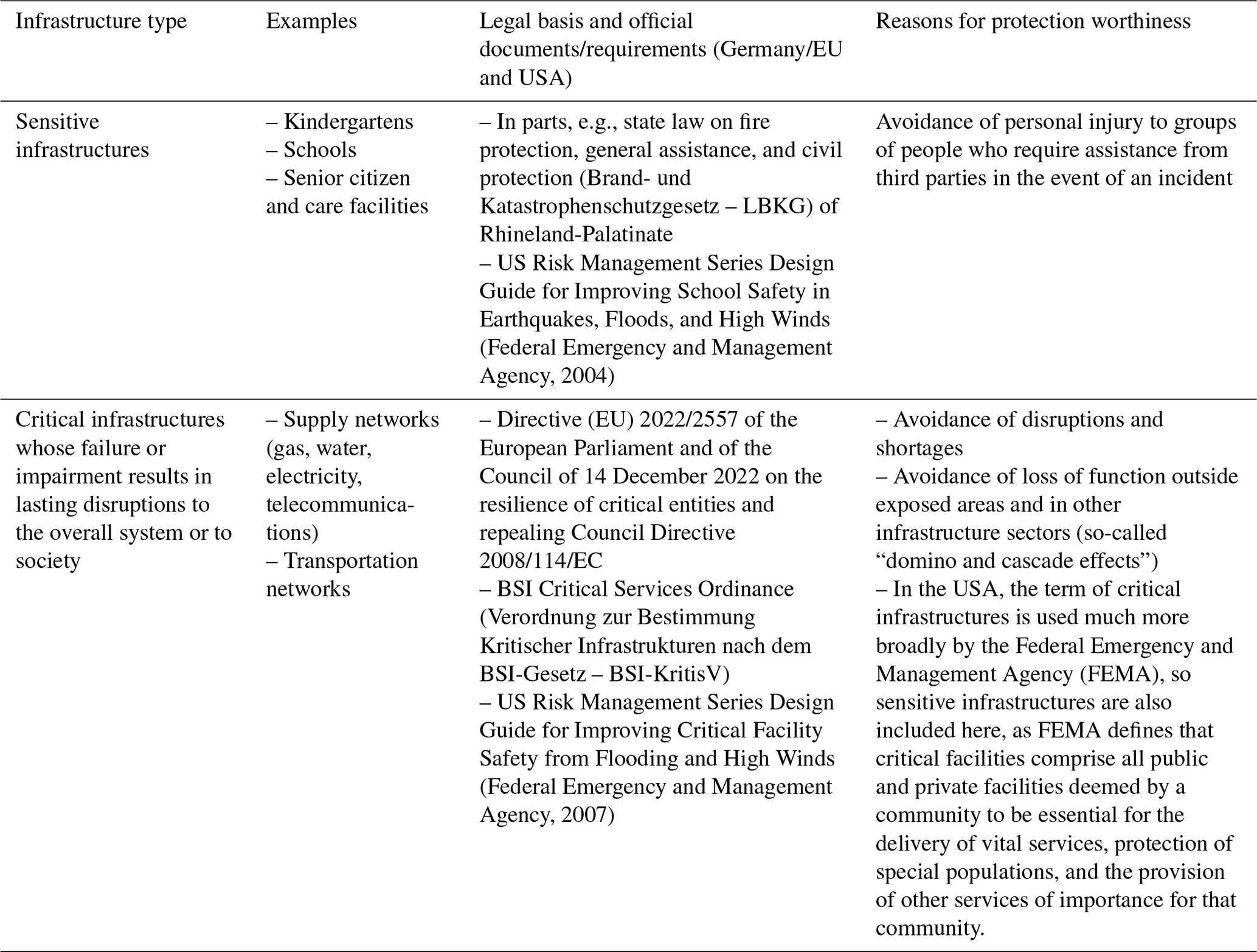
Table 1Excerpt of possible reasons for special protection needs of different types of infrastructures, adapted from Greiving et al. (2023).
Despite the different laws and publications that underscore the importance of critical and sensitive infrastructures in the context of extreme events and disasters, there are no standard procedures in Germany for identifying, assessing, or evaluating critical and sensitive infrastructures in local and regional planning in the context of extreme events. Also, the formulation of protection goals for these types of infrastructures and their users is still absent.
3.2 The impacts of the Ahr flood 2021 on critical and sensitive infrastructures
The Ahr Valley – a low mountain region with steep slopes and a narrow valley offering little space for settlement areas – encompasses a high exposure of infrastructures to floods and heavy precipitation as the event in 2021 dramatically revealed (Truedinger et al., 2023). Various schools, elderly homes, hospitals, and care homes in the region (e.g., in the city of Bad Neuenahr-Ahrweiler) are located close to the river and thus have been adversely affected by the heavy-rainfall-induced floods in 2021, which were caused by an upper-level trough that shifted eastward from the Atlantic Ocean to the southeast and encountered resistance from a quasi-stationary anticyclone positioned over northeastern Europe (Mohr et al., 2023). Heavy rainfall, on average about 75 mm across the Ahr catchment within a 24 h period, resulted in severe flooding within the Ahr Valley, notably on 14 and 15 July 2021 (Mohr et al., 2023). A total of 17 schools were hit particularly hard by the flood (Die Landesregierung Rheinland-Pfalz, 2022), so no classes could be held there after the flood for several weeks and months. In addition to schools, 42 kindergartens and daycare centers were affected in the county of Ahrweiler (Bundesministerium des Innern und für Heimat and Bundesministerium der Finanzen, 2022). In Bad Neuenahr-Ahrweiler, the largest town in the Ahr Valley, eight kindergartens and daycare centers were damaged. Since most of the children attending these facilities are 6 years old or younger, they are seldom able to get to safety on their own in the event of flooding, simply because of their physical and mental condition. Also, an integrative daycare center that accommodates children with disabilities as well as infants and toddlers in the direct vicinity of the Ahr was affected. Many other sensitive infrastructures were also affected – such as care facilities, 15 of which had to be evacuated in the county of Ahrweiler (Bundesministerium des Innern und für Heimat and Bundesministerium der Finanzen, 2022).
Reconstruction approaches in the Ahr Valley and other affected regions in Germany mainly focus on the compensation of experienced losses and damages (VV Wiederaufbau RLP, 2021; Birkmann et al., 2023) – thus hampering resilience building and not sufficiently capturing the specific nature and needs of critical and sensitive infrastructures, including the vulnerability of the people using it (Birkmann et al., 2023). A drastic example of these so-called sensitive infrastructures is the “Lebenshilfehaus”, a care home for people with disabilities, in the city of Sinzig. On the night of the 2021 flood event, 12 people with disabilities lost their lives because the water rose extremely quickly, and the management of the house and the local disaster protection units were unable to save these people (SWR, 2021). In this context, it is important to mention that the city of Sinzig is located downstream, which means that the flood had already destroyed places upstream in the afternoon and evening of the same day.
The challenges on how to better account for sensitive infrastructures with highly vulnerable population groups are not limited to this single case but are an important emerging issue in the reconstruction process that is unsolved up to now. Levana School (German: Levana-Schule) in Bad Neuenahr-Ahrweiler, which is discussed in depth in this paper, is another example. The school is a facility for children with special needs. Since the 2021 flood occurred during the evening and night, fortunately no students were in the school. At another time of the day, however, there could have been fatalities as well, and the inventory and the school building itself suffered severe damage in 2021 (Himmelrath, 2022). Besides direct damages, the losses of school and teaching time also need to be considered as important secondary damages.
In this regard, the 2021 flood disaster in the Ahr Valley in Germany and the subsequent reconstruction process is a good example and a powerful case study to explore our research questions and the importance of vulnerability and sensitivity in building resilience and finding concrete options for building back better sensitive infrastructures.
To explore the different aspects and challenges of strengthening protection and resilience – especially within the reconstruction process – and to obtain a risk framework for sensitive infrastructures, we have undertaken a qualitative approach. Our approach includes expert interviews, workshops, and discussions, on the basis of which the assessment method was developed. Afterward, a detailed case study was used to test the applicability of the assessment method, including other methods such as GIS analyses as well as observations and assessments of the flood impacts, the location, and the construction of the building. All methods used are listed in Table 2, along with the objectives and justification for the use of each method and the data obtained, where this can be reasonably specified.
Table 2Presentation of the methods, objectives, and justification for the use of the methods as well as the data obtained (to be stated where appropriate).
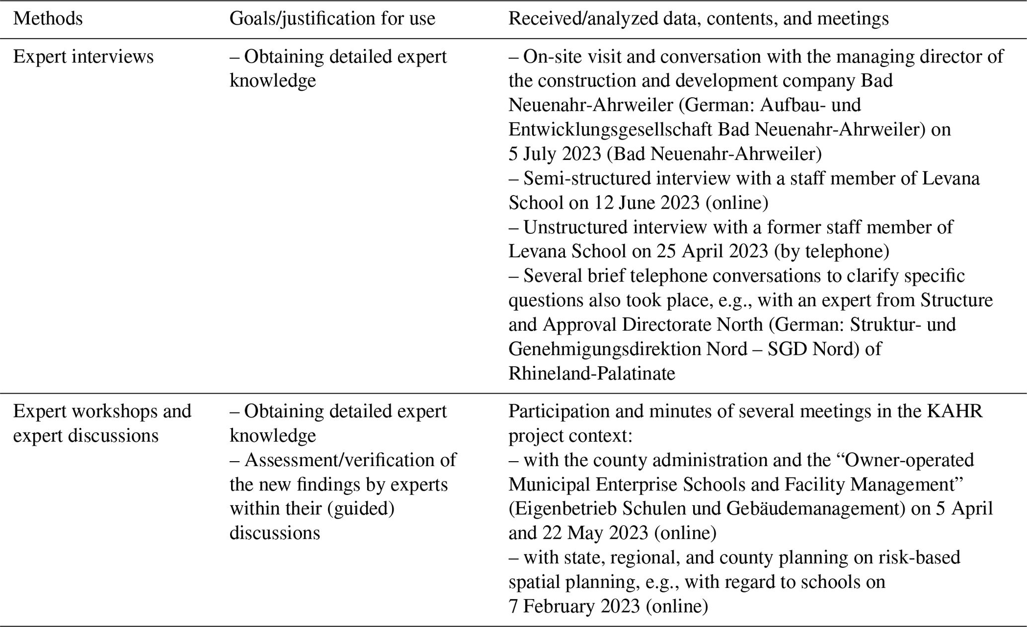
Expert interviews, workshops, and discussions were conducted in various settings to expand knowledge by obtaining expert knowledge and to assess and verify the scientific findings. For example, a semi-structured interview was conducted with a responsible staff member of Levana School, and a telephone interview was also held with a former principal of the school to assess the location and the challenges posed by the evacuation issue and the susceptibility of the children. A site visit and discussion were conducted with the managing director of the construction and development company Bad Neuenahr-Ahrweiler, whereby the city of Bad Neuenahr-Ahrweiler is, for example, the responsible authority for the inclusive kindergarten St Hildegard, which is located in close proximity to the original location of Levana School. In addition, several expert discussions took place with the county administration and the “Owner-operated Municipal Enterprise Schools and Facility Management” (German: Eigenbetrieb Schulen und Gebäudemanagement), where the limits and possibilities of funding and relocation were also discussed with the experts. A more general meeting was held with state, regional, and district planning on risk-based spatial planning, e.g., with regard to schools, to get a broader overview of the topic.
A case study was then used to test the assessment method developed using the aforementioned methods. In this test of real-life applicability, maps, flood impacts, and various documents and personal interviews were also analyzed and included.
Based on the current literature as well as the expert interviews, workshops, and discussions, a more systematic approach to assess the risk of sensitive infrastructures, with a particular emphasis on the vulnerability level of the user group and their capacity to cope with extreme events (which is in our case flooding), is shown below. In addition, the results of the applicability test and the demonstration of the evaluation method are presented using a detailed case study.
Thus, results presented and discussed in the following not only show relevance for the individual case study, but also provide a basis for a systematic assessment approach to better account for risk reduction and resilience building of sensitive infrastructures in reconstruction processes, as well as in completely new planning processes, as reconstruction after disasters can also be seen as new construction.
5.1 Systematic approach to determining the risk a sensitive infrastructure is facing
The following systematic approach to determining the risk that a sensitive infrastructure is facing with regard to flooding is based on our own considerations, analyses, and discussions in the KAHR research project (https://hochwasser-kahr.de/, last access: 12 June 2025) and builds on the current literature. Findings from intensive discussions and interviews with different stakeholders (see Table 2) have also been included. After application of the systematic risk determination approach, measures for reconstruction and new construction can be derived.
The matrix depicted in Fig. 1 illustrates the systematic framework; Table 3 contains the underlying questions.
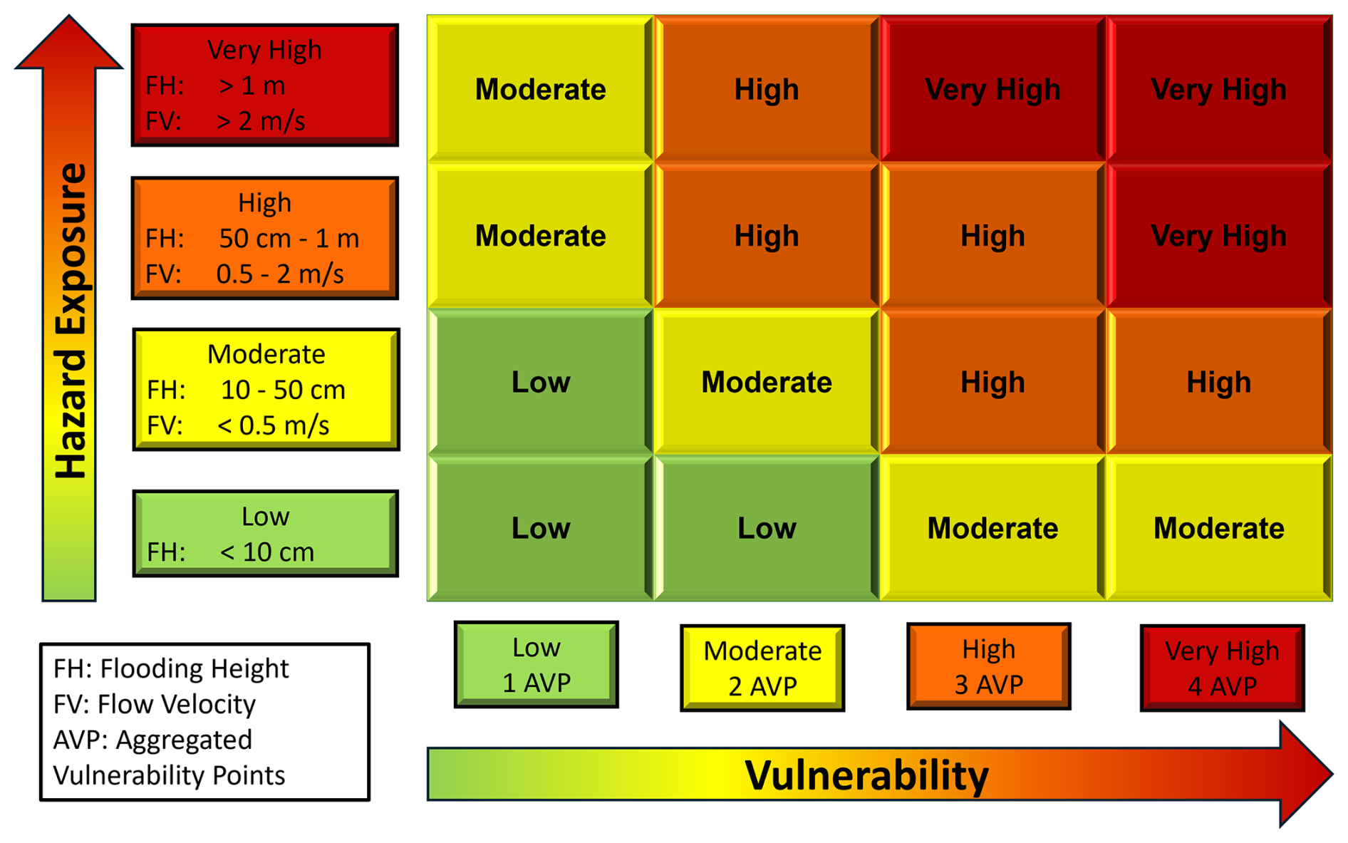
Figure 1Systematic framework matrix for determining the flood risk that a sensitive infrastructure is facing.
The matrix (Fig. 1) illustrates the logic and simplicity of the systematic approach. The questions and factors behind vulnerability (x axis) can be found in the following Table 3. These questions can help to assess vulnerability. In addition, information is provided on resources that can be used to assess these factors.
Hazard exposure (y axis) can be determined most easily with the help of flood and heavy-rain hazard maps as well as the flooding heights (FHs) and flow velocities (FVs) shown in them. Moreover, studies and modeling by research (e.g., engineering offices, universities) could be used. It is important to note that flood hazard maps could vary from federal state to federal state in Germany as, for example, the definition of HQ-extreme varies. The abbreviation HQ refers to the discharge volume during flooding. It is composed of H for flood (Hochwasser in German) and the discharge index Q. An HQ-extreme is an extreme event with rare probability of recurrence. In some federal states, HQ-extreme is, e.g., an event that occurs less frequently than once every 200 years on average, while in others it might be an event that occurs once every 1,000 years on average. The HQ-100 occurs once every 100 years on statistical average.
Nevertheless, up to now, only the HQ-100 has been used as a basis for assessment in Germany. We highly recommend (also due to climate change) to use at least the HQ-extreme as a basis for assessment. In the USA, FEMA is already transitioning from the 100-year flood event to a risk-based approach. While flood hazard maps are available for at least the larger rivers in Germany, this is not necessarily the case when it comes to heavy rain. And even if there are such maps, they are sometimes not publicly available and often vary greatly in quality, method, and level of detail. Sometimes cities have also produced individual maps.
Within our framework, vulnerability is a function of susceptibility and coping capacities (see also Sect. 2). For the susceptibility factor, there are two questions provided in Table 3. One vulnerability point can be noted for each affirmative answer, i.e., if the users have limited mobility or limited perception/communication skills. The coping capacity factor is subdivided into evacuation capability and self-protection. If one of the listed questions is answered with “No”, i.e., if there is, for example, no higher floor to which evacuation is possible without difficulty, one vulnerability point is added for this aspect of coping. A maximum of four aggregated vulnerability points (AVPs) can be reached in the end – two through existing susceptibility and two through non-existing coping capacities. The range of both hazard exposure and vulnerability goes from low to very high. The risk then results from the overlap of hazard exposure and vulnerability (see Fig. 1).
Table 3Important questions and notes on the risk assessment with regard to vulnerability components.

5.2 Application of the assessment framework to the Levana School case study
In the following, the assessment framework is now applied to the case study of Levana School to test the assessment method developed previously using a real-life and transferable example. By applying it, it will become clear how it is applied and what needs to be considered. In addition, various aspects of our assessment framework are also explained in more detail. Depending on the expected risk, appropriate options for action can then be taken.
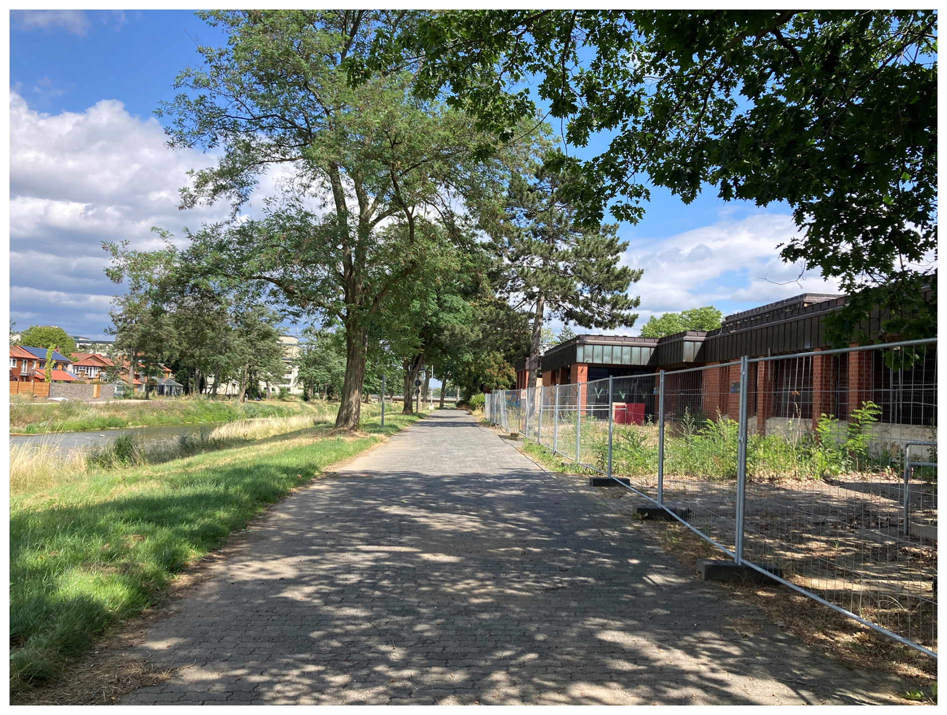
Figure 2The school complex “Levana School and Don Bosco School” (right) is located in the immediate vicinity of the Ahr (left) and was flooded to a height of approx. 2 m in 2021, with Levana School in particular accommodating highly vulnerable pupils (photo: Alessa Truedinger, 2023).
Levana School (see Fig. 2), which is run by the county of Ahrweiler and situated in the city of Bad Neuenahr-Ahrweiler, is a school with a focus on holistic and physical development and was attended by a total of 92 students in the school year 2022/2023, whereby all pupils of the school have a mental disability. Of these, 30 students had a special focus on physical development in 2022/2023, so they have both mental and physical disabilities. In the future, however, due to the division of students between the Burgweg school in Burgbrohl and Levana School, it is to be expected that more students who also have physical disabilities will be enrolled at Levana School, since this focus cannot be served by the Burgweg school.
Therefore, Levana School is a particularly sensitive and protection-worthy infrastructure, which, incidentally, is also very exposed to flooding and heavy rain and thus lends itself as a case study for theory testing. The transferability to many other special needs schools – especially those with the special needs areas “mental development” and “physical and motor development” – is given, as the design of schools for children with physical disabilities is usually very similar due to accessibility and as the composition of pupils always varies from year to year – even in Levana School itself.
5.2.1 Exposure
Within our assessment framework, exposure is a decisive factor in determining the risk and the subsequent choice of measures. Exposure can be determined, for instance, through flood and heavy-rain hazard maps, as well as past experiences.
Currently, due to the 2021 flood, Levana School is housed at a container complex on Schützenstraße in Bad Neuenahr-Ahrweiler, although the original location is next to the Don Bosco School (special needs school with a focus on learning and language) on St-Pius-Straße in the immediate vicinity of the river Ahr (see Fig. 3; Levana School is marked with a yellow circle), with the main exit – marked with a black arrow – pointing directly toward the Ahr. The original building, which could in principle be restored with the help of state subsidies, is exposed in various aspects. On the one hand, it is situated within the current HQ-100 zone, where, in certain areas, water levels would reach 1–2 m during a 100-year flood event (see Fig. 3). According to the SGD Nord authority, the water at the main entrance to the building is around 60 cm high at the new HQ-100, which has been recalculated and reclassified by the State Office for the Environment Rhineland-Palatinate (Landesamt für Umwelt Rheinland-Pfalz – LfU RP) after the 2021 flood. Additionally, parts of the only access road to the building (see Fig. 3, marked with a gray arrow) are flooded even higher. At the lowest terrain point of the road, the water is, according to the SGD Nord, 0.99 m high during an HQ-100 event. The flood hazard map even shows a water height of at least 1 m (see Fig. 3). Even at a gauge level of 410 cm in Altenahr, parts of the access road and the collection point of Levana School are already flooded (SGD Nord, 2024), whereby such a level – according to the old calculations – occurs on a statistical average slightly less frequently than every 20 years (Landesamt für Umwelt Rheinland-Pfalz, 2024b). As a result of climate change, such events will occur more frequently from a statistical point of view.
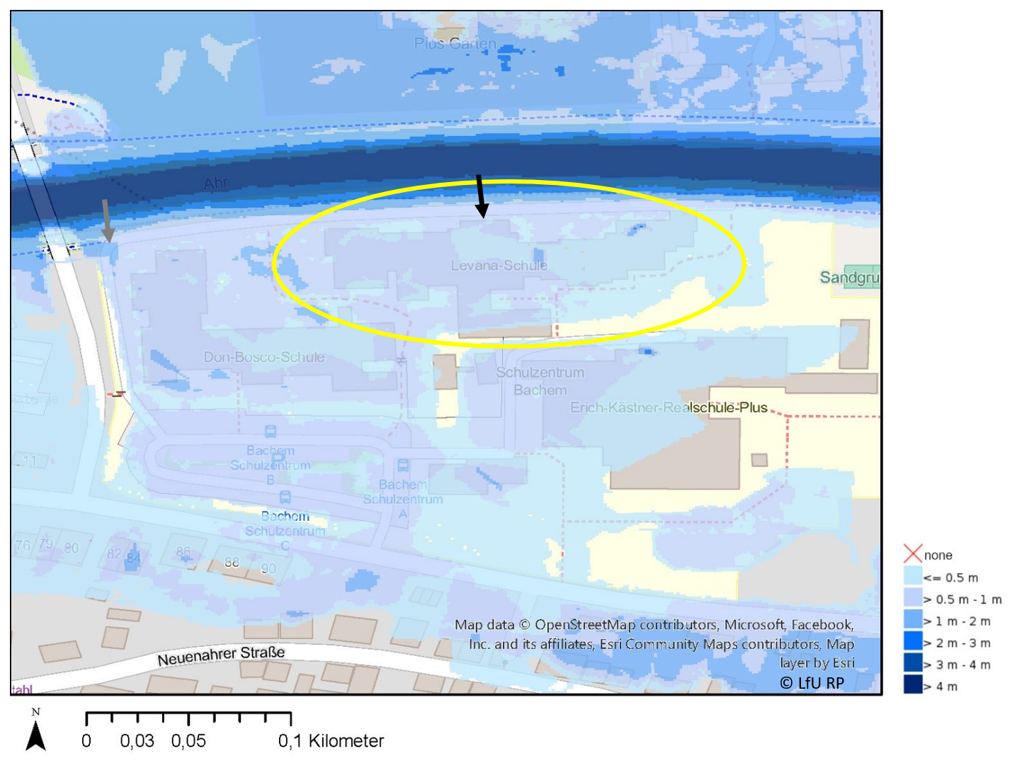
Figure 3Depiction of the HQ-100 floodplains, revised by the State Office for the Environment Rhineland-Palatinate (Landesamt für Umwelt Rheinland-Pfalz – LfU RP, 2024c) after the 2021 flood, in the vicinity of Levana School (Hochwassergefahrenkarte Rheinland-Pfalz, © LfU RP, https://wasserportal.rlp-umwelt.de/kartendienste, last access: 10 May 2024). The map was created using ArcGIS® software from Esri. ArcGIS® and ArcMap™ are intellectual property of Esri and are used with permission. Copyright © Esri. All rights reserved. For more information about Esri, visit http://www.esri.com (last access: 25 June 2025).
Levana School is also exposed to heavy-rain events and flash floods. According to the latest calculations from the State Office for the Environment Rhineland-Palatinate (Landesamt für Umwelt Rheinland-Pfalz, 2024a), the flow velocity of the water along the access road is up to 1 m s−1 with a water depth of up to 30 cm, already in the event of exceptionally heavy rainfall (SRI7, which is roughly equivalent to a 100-year event). For the part of the building facing away from the Ahr, the calculated water levels in this scenario are even up to 1 m with flow velocities of mostly 0 to 0.5 m s−1, in a few places even up to 1 m s−1. This means that even a merely exceptional heavy-rainfall event results in partly high exposure, and evacuation via the access road or via the garden to the rear becomes difficult or even impossible for users. During an extreme rainfall event, the flow velocities can partially reach more than 2 m s−1, and the flooding height can be up to 2 m.
For sensitive infrastructures, we recommend going beyond the 100-year event in any case, both in terms of riverine and pluvial flooding. In this case, however, the infrastructure is not only exposed in the event of an extreme event but already in the event of a 100-year event or even less – so the exposure is very high.
5.2.2 Susceptibility of the users
The students of Levana School are clearly very susceptible to flooding and heavy rainfall. On the one hand, this is because of the limited mobility of an average of about 30 students (possibly even more in the future), which prevents them from getting to safety independently and quickly; on the other hand, this is because of the mental disabilities of all the students, which also makes it difficult or even impossible for them to get to safety independently and quickly (see also Sect. 5.2.3) – in the worst case, the students even put themselves in danger as the floods of 2016 have already shown (former staff member of Levana School, personal communication, 25 April 2023). As the pupils are very susceptible, due to their limited mobility and/or perception, and need the help of third parties to evacuate, Levana School can be identified as a sensitive infrastructure. Within our framework, one can note one point for limited mobility and one point for limited perception and communication skills with regard to the aggregated vulnerability points.
Furthermore, in this case and with regard to the specific issue of actually rebuilding such a school after an extreme flood event, it is also important to consider that, according to the assessment of a medical expert, children with an intelligence impairment can show inexplicable behavioral abnormalities, partly with auto-aggressive and xeno-aggressive behavioral disorders, when triggered, for example, by flowing noises (Ahr during floods or also during heavy rain), which can lead to a danger for fellow students, teachers, and the students themselves (medical expert, personal communication, 2023). In addition, within this group of persons, it can be assumed that the psychological recovery after a flood event is much more difficult and protracted compared to other groups of persons. For example, children with intelligence impairment (including learning disabilities) find it difficult to undergo therapy after trauma due to IQ and language impairment, and as yet, there are hardly any specialized diagnostic or therapeutic methods for this group of people (Mayer, 2020). Moreover, children with profound developmental disabilities require continuity of the learning environment (staff member of Levana School, personal interview, 12 June 2023). Therefore, changing the learning site again after another extreme event, that cannot be ruled out, and changing group assignments should be avoided if possible. If, as a result of another flooding event, schooling has to be carried out in a different location again, this will be very detrimental for these children, as they may be thrown back into unfavorable behavior patterns.
In addition to the extremely high susceptibility of the students, the school inventory of Levana School is also very special and expensive, so a renewed procurement of, for example, lifting platforms, swimming pool technology, teaching material, rollators, and seating devices after a loss due to another flood will be complicated, lengthy, and expensive. During the flood of July 2021, helpers tried to secure the inventory until late at night; however, they put themselves in danger by doing so and were only able to move a small amount of inventory to safety (former staff member of Levana School, personal communication, 25 April 2023), as vertical relocation of the inventory was not possible due to the single-story construction of the building, leaving only the option of moving the inventory away with vehicles.
5.2.3 Coping: evacuation capability
Vertical evacuation. In the case of Levana School, vertical evacuation is not possible as it is a single-story school building due to its accessibility. Also, an evacuation to the roof has not yet been structurally provided for and is also not recommended due to the mental and physical limitations of the pupils. In addition, in extreme cases, as the 2021 event showed, the water can be several meters high, meaning that the roof of a single-story school building could also be flooded in future extreme events.
Warning time. An exact warning time for the evacuation of Levana School cannot be given for either a flood or a heavy-rainfall scenario. Floods caused by heavy rainfall in particular often involve shorter warning times and higher uncertainty (Bronstert et al., 2017). However, forecasts are always associated with uncertainties – in the summer of 2021, for example, the water level forecasts often only corresponded to the current water levels, which therefore did not include a longer warning time. The 2021 floods also showed that there are considerable problems with forecasting. For example, the water level forecasts were far too low for a long time and later in the course of the event were congruent with the actual water level at the gauge in Altenahr (county of Ahrweiler, personal communication, 11 July 2023). The forecast therefore had no predictive effect for preliminary planning, e.g., for an evacuation. Also, higher water levels were measured in the upper reaches of the Ahr at midday, but effective early warning and evacuation did not take place (Weidinger, 2023). The later order, which was issued shortly before midnight, to evacuate entire settlement areas within 50 m of the Ahr (Weidinger, 2023), also shows a lack of systematic evacuation and early warning as 50 m was far too little. Even if it generally takes several hours for a flood from the upper Ahr Valley to reach Bad Neuenahr-Ahrweiler, it should be noted that larger tributaries of the Ahr, such as the Sahrbach, can also lead to higher water levels in the Ahr and cause flooding, so the advance warning time should not just be discussed based on the flood development in the upper Ahr Valley, as floods can also arise from inflows into the Ahr, and the possible advance warning time can therefore be significantly shorter (SGD Nord, personal communication, 6 July 2023).
Although the exact warning times cannot be precisely defined from previous studies, it can be assumed that even with a warning time of several hours there are considerable challenges in evacuating people and securing and relocating the specific inventory of Levana School (former staff member of Levana School, personal communication, 25 April 2023; staff member of Levana School, personal interview, 12 June 2023) – as shown in the following.
Evacuation time and condition of the pupils. Levana School has an evacuation plan, whereby the current evacuation plan, which we have been given access to, is for the container complex at the replacement location. The current evacuation time is given as 8 to 10 min (fire department response time), whereby the evacuation only refers to leaving the building and not to further evacuation from the flood risk area. This means that the existing evacuation plan is designed for the event of a fire; there is currently no evacuation plan or comprehensive emergency exercises for the event of flooding.
In the case of flooding, it must be taken into account that the collection point and access routes will already be flooded very quickly (before water enters the building). The time that is set at 8 to 10 min for the simple evacuation of the building in the event of a fire will also be significantly longer in the event of heavy rainfall or flooding, as collection areas and access roads will also be affected and as the entire site will have to be evacuated. Also, supervision by unknown teachers in the event of a flood disaster can lead to significant problems, up to complete refusal on the part of the child (staff member of Levana School, personal interview, 12 June 2023). This can also occur if the child feels the panic and fear of the teachers. Even 2 years after the flood, some teachers as well as students are still afraid when it rains, and this feeling could be intensified in the old building (staff member of Levana School, personal interview, 12 June 2023). In addition, it should also be noted that the particularly vulnerable groups accommodated at Levana School are in an exceptional situation due to their mental and physical limitations in the event of an evacuation; i.e., it is likely that some students will become unpredictable and will not stay in one location for a long time but will often require individual support (staff member of Levana School, personal interview, 12 June 2023). Furthermore, according to the expert opinion, many of the students perceive emotional states very accurately and thus sense the teachers' hectic panic and anxiety, even if they try to suppress such feelings and states. The students, in turn, often mirror these emotional states, which makes evacuation (e.g., buckling up in the vehicle, waiting, or being carried out) more difficult (staff member of Levana School, personal interview, 12 June 2023). In addition to being affected at school, teachers are often also affected at home as well as in their families and are therefore worried about them (around 30 % of the teaching staff were affected in 2021).
Challenges in transportation and evacuation of the entire site. Due to the single-story design, a vertical evacuation is not possible – therefore pupils and teachers will be forced to leave the school building and grounds in the event of flooding. As there are numerous children with physical and/or mental disabilities (currently at least 30 children with significant motor disabilities and a total of 92 children with disabilities, whereby the proportion of children with motor disabilities is likely to increase), such an evacuation to a flood-proof accommodation option outside the flooded area would require a considerable amount of time, personnel, and technology. Many of the students are unable to leave the premises independently. Some of the older children, for example, would have to be carried by four people (staff member of Levana School, personal interview, 12 June 2023), and in rare cases pupils would even need a complete transport vehicle for themselves in order to be transported lying down out of the potential flooding area. As shown in Sect. 5.2.1, the building is already flooded by approx. 60 cm at an HQ-100, and parts of the access routes to the school are flooded even higher (see Fig. 3), so safe accessibility is no longer guaranteed even well below the new HQ-100. Emergency ambulances that could be used for an evacuation – according to the Federal Office of Civil Protection and Disaster Assistance (Bundesamt für Bevölkerungsschutz und Katastrophenhilfe – BBK) standards – can drive through a maximum water depth of 30 cm (Bundesamt für Bevölkerungsschutz und Katastrophenhilfe, 2010); similar values apply to other transporters, so accessibility to the school can no longer be guaranteed in the event of an HQ-100, as parts of the access road are flooded by more than 1 m in this scenario (see Fig. 3). Even at shallower water depths than 30 cm, damage to the vehicle cannot be ruled out, as a bow wave is created, for example, if the vehicle is driven through too quickly, which can damage the engine even at low water levels. A vehicle drifting in the water without a functioning engine is extremely dangerous, because in this case the water directs where the vehicle drifts to. Another problem is the availability of such vehicles in the event of an incident. In principle, the vehicles of the school transport service are necessary for the evacuation of pupils away from the entire site, but this is a private service provider, which therefore does not have to be available immediately and in sufficient numbers in the event of an incident. Corresponding emergency vehicles such as emergency ambulances could also be used during the evacuation, but these, in turn, are heavily involved during a widespread flood. On the one hand, they are involved in the acute rescue of lives; on the other hand, they are also involved (in addition to Levana School) in rescue operations at three kindergartens/day nurseries, four schools, and two clinics, which are to be evacuated as further sensitive infrastructures within a radius of around 1 km.
Alternatively, it would also be possible to evacuate the pupils via the garden in the rear, but this would again increase the distance significantly; it can be assumed that these paths are difficult to walk on in (heavy) rain and that self-evacuation is out of the question, especially for children with limited motor skills who need a wheelchair. Moreover, this type of evacuation would require a lot of staff, as some pupils can only be carried with four helpers; according to the staff member, it is practically impossible to get to elevated and therefore flood-safe areas in this way, i.e., without buses (staff member of Levana School, personal interview, 12 June 2023).
Since the evacuation capability is very low, a vulnerability point can be noted here as well.
5.2.4 Coping: self-protection
In principle, it is in the first instance possible to keep the students of Levana School in the school during an incipient event, since even short outages of electricity, heating, or water do not directly lead to life-threatening situations, since the students – unlike, for example, intensive-care patients in hospitals – are never permanently resident in the school and thus have, for example, mobile assistive devices. However, the school is not prepared for longer outages, which is why a vulnerability point can be added here as well.
Moreover, it is also wrong to assume that the pupils can simply remain at Levana School in the event of a flood. Although the flooding map only shows a slight flooding of the ground floor of the school in the event of an HQ-100, which could be averted by structural measures, significantly higher flooding can also occur, as 2021 has shown. In addition, flooding can also raise the floor slab, so not only the flooding of the ground floor, but also the possible raising or partial destruction of the floor slab could pose a significant problem for Levana School.
5.2.5 Conclusion on the Levana School case study
All in all, based on our assessment framework, the risk that Levana School and its users are facing with regard to riverine and pluvial flooding is considered to be very high. The aggregated vulnerability points result in four, i.e., a very high vulnerability, and the hazard exposure is already very high at an HQ-100 with flooding depths of over 1 m in some places. With an HQ-extreme, which should be better used as a basis for assessing sensitive infrastructure, the flood depths are even significantly higher. During an extreme heavy-rainfall event, flow velocities of over 2 m s−1 and water depths of up to 2 m are also to be expected. This means that the hazard exposure is also very high. According to the risk matrix, this results in a very high risk. Due to this very high risk, we strongly recommend the complete relocation of the school within the reconstruction process.
Apart from the risk assessment, other factors also play a role in such a decision, e.g., financing or proximity to users and other facilities.
Financing/funding. In terms of risk-based and resilient reconstruction and due to the extensive damage that has already occurred, it is possible to finance the relocation of the school from the reconstruction fund (Ministry of Interior and for Sports Rhineland-Palatinate, personal communication, 7 May 2024). Particularly with regard to sensitive infrastructures with high to very high risks, our assessment framework can also be used to qualify and support the decision to relocate as has been the case with Levana School (Au, 2024).
Proximity to users and other facilities. Proximity to users can also be an important factor, as the users often originate from a limited catchment area, and the infrastructure therefore cannot be relocated anywhere. Sometimes proximity to other infrastructure is also required. For example, the neighboring Don Bosco School, a special needs school for children with learning difficulties, needs everyday facilities in the immediate vicinity in order to practice everyday situations with its pupils.
In the case of Levana School, the point of proximity to users can be disregarded in principle as long as relocation takes place within the county, as the school's catchment area covers the entire county. Nevertheless, the availability of alternative locations is essential for relocation – and these locations must also meet certain criteria and requirements. For example, the pupils at Levana School also need certain everyday infrastructures such as supermarkets or road crossings nearby in order to be able to practice everyday life (staff member, personal interview, 12 June 2023). Therefore, the location factor should not be disregarded. Nevertheless, as already mentioned, Levana School has a large catchment area and suitable alternative locations should therefore be found – so we strongly recommend relocating the school and building a climate-resilient new school in a different, safer location, as the risk could be classified as very high using our assessment method.
As demonstrated by the case study of Levana School, which is a special needs school with a focus on mental as well as motor and physical development with a highly vulnerable user group, our assessment framework can be effectively applied to determine the risk that a sensitive infrastructure is facing with regard to heavy rain and flooding. Building upon this, appropriate measures can then be derived, potentially qualifying and even expediting reconstruction planning as the assessment framework also enables prioritization of measures for various infrastructures in the reconstruction process. We mean qualifying in the sense that, in the context of climate-resilient and sustainable planning and reconstruction, relocation should be financially and technically supported, particularly in cases of high to very high risks, by government entities. Accordingly, funding regulations should also be adjusted to enable financing beyond the mere extent of the damages if, for example, this is warranted due to the high risk and the protection worthiness of the infrastructure, which can be determined by such new assessment frameworks. In the case of Levana School, this risk assessment was actually used to justify a significantly more expensive relocation instead of on-site reconstruction (Au, 2024). Reconstruction should be pursued with the aim of climate adaptation and resilience, as well as the economical use of tax resources, so that modification and moderate settlement withdrawal are indicated, especially for particularly sensitive infrastructures that are worthy of protection and at risk, and so that the window of opportunity for reconstruction is used optimally (Birkmann et al., 2022, 2023).
The applicability of the assessment framework extends to other infrastructures such as nursing homes or kindergartens, with Levana School serving as a transferable example. However, there are limitations to its application, such as data availability. Without sufficient data on flood and heavy-rain hazards, user groups, or evacuation capability, a comprehensive risk assessment cannot be conducted. Additionally, it should be noted that during a real disaster processes may not necessarily unfold as planned and practiced beforehand. Therefore, we recommend higher standards of protection for sensitive infrastructures and, where possible, relocation to less exposed areas, especially if the risk is high to very high. However, a low risk does not mean that nothing needs to be done. A residual risk will always remain. In addition, structural measures such as evacuation options to higher levels or off the roof can also be implemented. Even for non-sensitive infrastructures that are very exposed and offer no evacuation options, it is crucial to consider resilience measures, as human lives can be at risk here too.
Since our focus was on the assessment framework, which we also verified using a real-life example, future research could focus more on the resulting resilience measures. Moreover, the assessment framework could also be extended or generalized with regard to other hazards in the future. Additionally, an adaptation of the framework for critical infrastructure could also be investigated.
Our paper has highlighted the current legal requirements and definitions regarding critical and sensitive infrastructures – especially in Germany – and what the difference between critical and sensitive infrastructures is. We understand sensitive infrastructures as those that are not necessarily essential for the functioning of society but can still be of significant importance and host particularly vulnerable user groups who may require assistance from third parties in the case of an incident. Due to the lack of procedures and approaches for identifying such sensitive infrastructures, assessing their risk, and developing resilience-enhancing measures, we have developed a new assessment framework that allows for the identification of sensitive infrastructures and the assessment of risk. Especially in the case of high to very high risks, it is recommended to consider and, if possible, to implement the relocation of sensitive infrastructures as well as, if needed, to revise existing funding guidelines. Ultimately, it is always a matter of weighing up the various factors, such as the flood risk, the location and proximity to certain other infrastructures, the financing, the structural and organizational precautionary options, or the demands placed on the infrastructures by the users. However, greater emphasis should be placed on risk, especially in reconstruction, when it comes to sensitive infrastructures, which is enabled by our assessment framework. Due to the high protection worthiness, climate change, and the fact that sensitive infrastructures are often intended to provide a safe location for decades, we also recommend (when considering exposure and relocation) not using events with a statistical return period of 100 years as the design events but rather extreme events. Especially for reconstruction, the assessment framework can also be used to prioritize options, thereby accelerating processes and qualifying decisions, such as those regarding site selection and the respective funding. Furthermore, it can ensure that the needs of particularly vulnerable population groups can be taken into account more strongly and systematically in reconstruction and new construction.
Some of the confidential minutes and personal communication cannot be made public due to data protection. However, mainly publicly accessible sources were used. If specific data are required, please contact the corresponding author.
JB was engaged in funding acquisition. AT and JB conceptualized the paper and developed the methodology. AT conducted the investigation with partial support from JB and MF. AT prepared the original draft including visualization, and JB, MF, and CF reviewed and edited the manuscript.
The contact author has declared that none of the authors has any competing interests.
Publisher’s note: Copernicus Publications remains neutral with regard to jurisdictional claims made in the text, published maps, institutional affiliations, or any other geographical representation in this paper. While Copernicus Publications makes every effort to include appropriate place names, the final responsibility lies with the authors.
This article is part of the special issue “Strengthening climate-resilient development through adaptation, disaster risk reduction, and reconstruction after extreme events”. It is a result of the EGU General Assembly 2023, session NH9.3 “Resilience building and risk reduction: Assessments, frameworks, tools and experiences”, Vienna, Austria, 24 April 2023.
We are very grateful for the valuable and productive cooperation with the county of Ahrweiler and the different experts.
This research has been supported by the Bundesministerium für Bildung und Forschung (grant no. 01LR2102A).
This open-access publication was funded by the University of Stuttgart.
This paper was edited by Viktor Rözer and reviewed by two anonymous referees.
Almeida, L. Q. de, Welle, T., and Birkmann, J.: Disaster risk indicators in Brazil: A proposal based on the world risk index, Int. J. Disast. Risk Re., 17, 251–272, https://doi.org/10.1016/j.ijdrr.2016.04.007, 2016.
Asian Development Bank: Schools with Earthquake-proof Technology Survive Nepali Disaster, https://www.adb.org/news/features/schools-earthquake-proof-technology-survive-nepali-disaster (last access: 10 April 2024), 2015.
Au, B.: Weg ist frei: Levana-Schule bekommt neuen Standort im Kreis Ahrweiler, https://www.rhein-zeitung.de/lokales/kreis-ahrweiler/weg-ist-frei-levana-schule-bekommt-neuen-standort-im-kreis-ahweiler_arid-2693591.html (last access: 9 January 2025), 2024.
Beccari, B.: A Comparative Analysis of Disaster Risk, Vulnerability and Resilience Composite Indicators, PLoS currents, 8, https://doi.org/10.1371/currents.dis.453df025e34b682e9737f950 70f9b970, 2016.
Birkmann, J., Cardona, O. D., Carreño, M. L., Barbat, A. H., Pelling, M., Schneiderbauer, S., Kienberger, S., Keiler, M., Alexander, D., Zeil, P., and Welle, T.: Framing vulnerability, risk and societal responses: the MOVE framework, Nat. Hazards, 67, 193–211, https://doi.org/10.1007/s11069-013-0558-5, 2013.
Birkmann, J., Schüttrumpf H., Trüdinger, A., Schüller, A., Huck, A., Kleber, A., Thiebes, B., Droste-Franke, B., Guse, B., Merz, B., Brüll, C., Kuhlicke, C., Stein, C., Mudersbach, C., Michalski, D., Molinari, D., Rodriguez Castro, D., Kirsten, D., Thieken, A., Klopries, E.-M., Bachofer, F., Steudtner, F., Johann, G., Lauer, H., Luhmann, H.-J., Arenz, H.-T., Zachert, H., Kreibich, H., Apel, H., Meyer, H., Frančik, H., Hoppe, H., Sauter, H., Hasse, J., Moßgraber, J., Stamm, J., Emde, K., Laranjeira, K., Burghardt, L., Kirschbauer, L., Madruga de Brito, M., Evers, M., Disse, M., Ravan, M., Schaefer, M., Garschagen, M., Boronowsky, M., Paul, M., Thiessen, N., Koch, O., Mahrenholz, P., Meier, P., Bellanova, P., Jüpner, R., Reinstädtler, S., Vorogushyn, S., Schöttmer, S., Greiving, S., Wolf, S., Nietgen, T., Hellmund, T., Korrmann, V., Kron, W., and Reckhaus, Z.: 10 Empfehlungen aus Sicht der Wissenschaft zum Thema Wiederaufbau und Zukunftsfähigkeit der flutbetroffenen Regionen, https://hochwasser-kahr.de/index.php/de/alle-produkte/10-empfehlungen (last access: 18 April 2024), 2022.
Birkmann, J., Schüttrumpf, H., Handmer, J., Thieken, A., Kuhlicke, C., Truedinger, A., Sauter, H., Klopries, E.-M., Greiving, S., Jamshed, A., Merz, B., Solecki, W., and Kirschbauer, L.: Strengthening resilience in reconstruction after extreme events – Insights from flood affected communities in Germany, Int. J. Disast. Risk Re., 96, 103965, https://doi.org/10.1016/j.ijdrr.2023.103965, 2023.
Bronstert, A., Agarwal, A., Boessenkool, B., Fischer, M., Heistermann, M., Köhn-Reich, L., Moran, T., and Wendi, D.: Die Sturzflut von Braunsbach am 29. Mai 2016 – Entstehung, Ablauf und Schäden eines “Jahrhundertereignisses”, Teil 1: Meteorologische und hydrologische Analyse, https://doi.org/10.5675/HyWa_2017,3_1, 2017.
Bundesamt für Bevölkerungsschutz und Katastrophenhilfe: Ausstattungssatz, Beladeplan und Typenblatt für Notfallkrankenwagen Typ B – Fahrzeug: Mercedes-Benz Sprinter 316 CDI, BBK III.6, https://www.lv-saarland.drk.de/fileadmin/user_upload/III6_Begleitheft_KTWTypB_7042_09.pdf (last access: 25 June 2025), 2010.
Bundesministerium des Innern und für Heimat and Bundesministerium der Finanzen: Bericht zur Hochwasserkatastrophe 2021: Katastrophenhilfe, Wiederaufbau und Evaluierungsprozesse, https://www.bmi.bund.de/SharedDocs/downloads/DE/veroeffentlichungen/2022/abschlussbericht-hochwasserkatastrophe.pdf?__blob=publicationFile&v=4 (last access: 25 June 2025), 2022.
Bündnis Entwicklung Hilft/IFHV: WorldRiskReport, Berlin, https://entwicklung-hilft.de/wp-content/uploads/2025/02/WRB_2024_Bericht_online.pdf (last access: 25 June 2025), 2024.
Bushong, L. C. and Welch, P.: Critical healthcare for older adults post Hurricane Ian in Florida, United States, J. Public Health Pol., 44, 674–684, https://doi.org/10.1057/s41271-023-00444-3, 2023.
Chakraborty, J., Grineski, S. E., and Collins, T. W.: Hurricane Harvey and people with disabilities: Disproportionate exposure to flooding in Houston, Texas, Soc. Sci. Med., 226, 176–181, https://doi.org/10.1016/j.socscimed.2019.02.039, 2019.
Der Paritätische Gesamtverband: Positionspapier: Bedarfe vulnerabler Bevölkerungsgruppen im Katastrophenfall, Berlin, https://www.der-paritaetische.de/fileadmin/user_upload/171215_Positionspapier_Katastrophenfall_Bedarfe_vulnerable_Personengruppen_final.pdf (last access: 25 June 2025), 2017.
Die Landesregierung Rheinland-Pfalz: Ein Jahr Wiederaufbau in Rheinland-Pfalz nach der Naturkatastrophe vom 14./15. Juli 2021, Mainz, Germany, https://wiederaufbau.rlp.de/fileadmin/wiederaufbau/2022/07-Juli/Ein-Jahr-Wiederaufbau-in-RLP.pdf (last access: 25 June 2025), 2022.
Estoque, R. C., Ishtiaque, A., Parajuli, J., Athukorala, D., Rabby, Y. W., and Ooba, M.: Has the IPCC's revised vulnerability concept been well adopted?, Ambio, 52, 376–389, https://doi.org/10.1007/s13280-022-01806-z, 2023.
European Parliament and Council: Directive (EU) 2022/2557 of the European Parliament and of the Council of 14 December 2022 on the resilience of critical entities and repealing Council Directive 2008/114/EC: CER, https://eur-lex.europa.eu/eli/dir/2022/2557/oj (last access: 25 June 2025), 2022.
Federal Emergency and Management Agency: Risk Management Series Design Guide for Improving School Safety in Earthquakes, Floods, and High Winds, Washington, DC, FEMA, 424, https://www.fema.gov/pdf/plan/prevent/rms/424/fema424.pdf (last access: 25 June 2025), 2004.
Federal Emergency and Management Agency: Risk Management Series Design Guide for Improving Critical Facility Safety from Flooding and High Winds, Washington, DC, FEMA, 543, https://www.fema.gov/sites/default/files/2020-08/fema543_design_guide_complete.pdf (last access: 25 June 2025), 2007.
Federal Office for Information Security: What are Critical Infrastructures?, https://www.bsi.bund.de/EN/Themen/Regulierte-Wirtschaft/Kritische-Infrastrukturen/Allgemeine-Infos-zu-KRITIS/allgemeine-infos-zu-kritis.html, last access: 17 January 2024.
Field, C. B., Barros, V., Stocker, T., Qin, D., Dokken, D. J., Ebi, K. L., Mastrandrea, M., Mach, K. J., Plattner, G.-K., Allen, S. K., Tignor, M., and Midgley, P. M. (Eds.): Managing the risks of extreme events and disasters to advance climate change adaptation: Special report of the Intergovernmental Panel on Climate Change, Cambridge Univ. Press, Cambridge, 582 pp., ISBN 978-1-107-02506-6, 2012.
Filiol, E. and Gallais, C.: Critical Infrastructure: Where we Stand Today?, in: Proceedings of the 9th International Conference on Cyber Warfare and Security: ICCWS-2014 Purdue University West Lafayette, Indiana, USA, 24–25 March 2014, Academic Conferences and Publishing International Limited, Reading, UK, 47–57, ISBN 978-1-909507-05-0, 2014.
Global Facility for Disaster Reduction and Recovery and The World Bank Social Development Global Practice: Disability-Inclusive Disaster Recovery, NW, Washington, DC, 20433, USA, Disaster Recovery Guidance Series, https://documents1.worldbank.org/curated/en/265011593616893420/pdf/Disability-Inclusive-Disaster-Recovery.pdf (last access: 25 June 2025), 2020.
Greiving, S.: Stellungnahme vom 11. Januar 2023 von Herrn Professor Dr. Stefan Greiving, TU Dortmund University, in: Anhörverfahren der Enquete-Kommission 18/1 “Zukunftsstrategien zur Katastrophenvorsorge” zum Thema “Klimawandelangepasste Flächen- und Raumplanung, rechtliche und verwaltungsfachliche Grundlagen, Bundesraumordnungsplan” am 7. Februar 2023, Landtag Rheinland-Pfalz, https://dokumente.landtag.rlp.de/landtag/vorlagen/1-95-18.pdf (last access: 25 June 2025), 2023.
Greiving, S., Kruse, P., Othmer, F., Fleischhauer, M., and Fuchs, M.: Implementation of Risk-Based Approaches in Urban Land Use Planning – The Example of the City of Erftstadt, Germany, Sustainability, 15, 15340, https://doi.org/10.3390/su152115340, 2023.
Hartz, A., Saad, S., Bächle, S., Fleischhauer, M., Greiving, S., Gollmann, C., Kirstein, M., and Nguyen, B.-H.: Vorsorgendes Risikomanagement in der Regionalplanung. Handlungshilfe für die Regionalplanung, Bundesinstitut für Bau-, Stadt- und Raumforschung (BBSR) im Bundesamt für Bauwesen und Raumordnung (BBR), Bonn, https://www.bbsr.bund.de/BBSR/DE/veroeffentlichungen/sonderveroeffentlichungen/2020/risikomanagement (last access: 25 June 2025), 2020.
Hellström, T.: Critical infrastructure and systemic vulnerability: Towards a planning framework, Safety Sci., 45, 415–430, https://doi.org/10.1016/j.ssci.2006.07.007, 2007.
Himmelrath, A.: Was wurde aus... der zerstörten Förderschule in Ahrweiler?, Ein Jahr nach der Flut, SPIEGEL Panorama, 14.07.2022, https://www.spiegel.de/panorama/bildung/flutkatastrophe-was-wurde-aus-der-zerstoerten-foerderschule-in-ahrweiler-a-1b48ac44-cf93-46c1-95db-3fa3c7693ecf (last access: 25 June 2025), 2022.
IPCC: Summary for policymakers, in: Climate Change 2014: Impacts, Adaptation, and Vulnerability. Part A: Global and Sectoral Aspects, Contribution of Working Group II to the Fifth Assessment Report of the Intergovernmental Panel on Climate Change, edited by: Field, C. B., Barros, V. R., Dokken, D. J., Mach, K. J., Mastrandrea, M. D., Bilir, T. E., Chatterjee, M., Ebi, K. L., Estrada, Y. O., Genova, R. C., Girma, B., Kissel, E. S., Levy, A. N., MacCracken, S., Mastrandrea, P. R., and White, L.L., Cambridge, United Kingdom and New York, NY, USA, https://www.ipcc.ch/site/assets/uploads/2018/02/ar5_wgII_spm_en.pdf (last access: 25 June 2025), 2014.
Kelman, I. and Stough, L. M.: (Dis)Ability and (Dis)Aster, in: Disability and Disaster, edited by: Kelman, I. and Stough, L. M., Palgrave Macmillan UK, London, 3–14, https://doi.org/10.1057/9781137486004_1, 2015a.
Kelman, I. and Stough, L. M. (Eds.): Disability and Disaster, Palgrave Macmillan UK, London, ISBN 978-1-137-48599-1, 2015b.
Koks, E. E., van Ginkel, K. C. H., van Marle, M. J. E., and Lemnitzer, A.: Brief communication: Critical infrastructure impacts of the 2021 mid-July western European flood event, Nat. Hazards Earth Syst. Sci., 22, 3831–3838, https://doi.org/10.5194/nhess-22-3831-2022, 2022.
Landesamt für Umwelt Rheinland-Pfalz: Sturzflutkarte, https://wasserportal.rlp-umwelt.de/auskunftssysteme/sturzflutgefahrenkarten/sturzflutkarte (last access: 11 January 2025), 2024a.
Landesamt für Umwelt Rheinland-Pfalz: Pegel Altenahr/Ahr – Pegelkennwerte, https://www.hochwasser.rlp.de/flussgebiet/ahr/altenahr#pegelkennwerte, last access: 18 April 2024b.
Landesamt für Umwelt Rheinland-Pfalz: Hochwassergefahrenkarte Rheinland-Pfalz, https://wasserportal.rlp-umwelt.de/kartendienste last access: 10 May 2024c.
Mayer, B.: Trauma und geistige Beeinträchtigung: eine Studie zur Anwendung der NET (Narrativen Expositionstherapie) bei Menschen mit geistiger oder psychischer Beeinträchtigung, Dissertation, University of Konstanz, Konstanz, http://nbn-resolving.de/urn:nbn:de:bsz:352-2-qbapx3ibbtjx8 (last access: 25 June 2025), 2020.
Mohr, S., Ehret, U., Kunz, M., Ludwig, P., Caldas-Alvarez, A., Daniell, J. E., Ehmele, F., Feldmann, H., Franca, M. J., Gattke, C., Hundhausen, M., Knippertz, P., Küpfer, K., Mühr, B., Pinto, J. G., Quinting, J., Schäfer, A. M., Scheibel, M., Seidel, F., and Wisotzky, C.: A multi-disciplinary analysis of the exceptional flood event of July 2021 in central Europe – Part 1: Event description and analysis, Nat. Hazards Earth Syst. Sci., 23, 525–551, https://doi.org/10.5194/nhess-23-525-2023, 2023.
Mulowayi, E., Coffey, V., Bunker, J., and Trigunarsiah, B.: The influence of critical infrastructure interdependencies on post-disaster reconstruction: Elements of infrastructure interdependency that impede the post-disaster recovery effort, in: Proceedings of the 31st Annual Association of Researchers in Construction Management Conference, ARCOM, Lincoln, UK, 7–9 September, 135–144, https://www.arcom.ac.uk/-docs/proceedings/5c0fdbc531a915738ce7dcc9bfa2ade9.pdf (last access: 25 June 2025), 2015.
Office of the Representative for the Interests of Persons with Disabilities and DRK Landesverband Baden-Württemberg: Schutz für alle Menschen bei Katastrophen und in Krisen, https://www.baden-wuerttemberg.de/de/service/presse/pressemitteilung/pid/schutz-fuer-alle-menschen-bei-katastrophen-und-in-krisen (last access: 10 April 2024), 2023.
Reisinger, A., Howden, M., Vera, C., Garschagen, M., Hurlbert, M., Kreibiehl, S., Mach, K. J., Mintenbeck, K., O’Neill, B., Pathak, M., Pedace, R., Pörtner, H.-O., Poloczanska, E., Rojas Corradi, M., Sillmann, J., van Aalst, M., Viner, D., Jones, R., Ruane, A. C., and Ranasinghe, R.: The Concept of Risk in the IPCC Sixth Assessment Report: A Summary of Cross-Working Group Discussions, Geneva, Switzerland, 2020.
Ronoh, S., Gaillard, J. C., and Marlowe, J.: Children with disabilities and disaster preparedness: a case study of Christchurch, Kōtuitui, New Zealand Journal of Social Sciences Online, 10, 91–102, https://doi.org/10.1080/1177083X.2015.1068185, 2015.
Rouhanizadeh, B. and Kermanshachi, S.: Post-disaster reconstruction of transportation infrastructures: Lessons learned, Sustain. Cities Soc., 63, 102505, https://doi.org/10.1016/j.scs.2020.102505, 2020.
Sarker, P. and Lester, H. D.: Post-Disaster Recovery Associations of Power Systems Dependent Critical Infrastructures, Infrastructures, 4, 30, https://doi.org/10.3390/infrastructures4020030, 2019.
SGD Nord: Ausdehnung von Hochwasser bei verschiedenen Pegelständen, https://sgdnord.rlp.de/themen/wiederaufbau-ahr/hochwasseranschlaglinien, last access: 18 April 2024.
Stewart, G. T., Kolluru, R., and Smith, M.: Leveraging public-private partnerships to improve community resilience in times of disaster, Int. J. Phys. Distr. Log., 39, 343–364, https://doi.org/10.1108/09600030910973724, 2009.
SWR: Hochwasser in Sinzig: Zwölf Tote im Lebenshilfehaus, https://www.swr.de/swraktuell/rheinland-pfalz/koblenz/viele-tote-im-sinziger-lebenshilfe-haus-100.html (last access: 11 December 2023), 2021.
Ton, K. T., Gaillard, J. C., Adamson, C. E., Akgungor, C., and Ho, H. T.: Expanding the capabilities of people with disabilities in disaster risk reduction, Int. J. Disast. Risk Re., 34, 11–17, https://doi.org/10.1016/j.ijdrr.2018.11.002, 2019.
Truedinger, A. J., Jamshed, A., Sauter, H., and Birkmann, J.: Adaptation after Extreme Flooding Events: Moving or Staying? The Case of the Ahr Valley in Germany, Sustainability, 15, 1407, https://doi.org/10.3390/su15021407, 2023.
UN-Habitat and AXA: Supporting Safer Housing Reconstruction After Disasters – Planning and Implementing Technical Assistance at Scale, https://reliefweb.int/report/world/supporting-safer-housing-reconstruction-after-disasters-planning-and-implementing (last access: 25 June 2025), 2019.
United Nations Centre for Regional Development: Earthquake safety construction: From guidelines to practice: Experiences from School Earthquake Safety Initiative Project, https://uncrd.un.org/content/pub-school-retrofit-earthquake-safety (last access: 10 April 2024), 2009.
United Nations Office for Disaster Risk Reduction: Sendai framework for disaster risk reduction 2015–2030, https://www.undrr.org/publication/sendai-framework-disaster-risk-reduction-2015-2030 (last access: 25 June 2025), 2015.
United Nations Office for Disaster Risk Reduction: Sendai Framework Terminology on Disaster Risk Reduction: Critical infrastructure, https://www.undrr.org/terminology/critical-infrastructure, last access: 17 January 2024a.
United Nations Office for Disaster Risk Reduction: Vulnerability: Sendai Framework Terminology on Disaster Risk Reduction, https://www.undrr.org/terminology/vulnerability, last access: 10 April 2024b.
VV Wiederaufbau RLP: Verwaltungsvorschrift zur Gewährung staatlicher Finanzhilfen zur Beseitigung der Schäden aufgrund des Starkregens und des Hochwassers am 14. und 15. Juli 2021 in den Landkreisen Ahrweiler, Bernkastel-Wittlich, Cochem-Zell, Eifelkreis Bitburg-Prüm, Mayen-Koblenz, Trier-Saarburg und Vulkaneifel sowie der kreisfreien Stadt Trier (VV Wiederaufbau RLP 2021), Ministerialblatt der Landesregierung von Rheinland-Pfalz, Nr. 36, 1. Oktober 2021, 126–140, https://wiederaufbau.rlp.de/fileadmin/wiederaufbau/2023/05-Mai/VV_Wiederaufbau_RLP_2021_MinBlatt__1_.pdf (last access: 25 June 2025), 2021.
Weidinger, A.-L.: Was ist in der Flutnacht passiert? – Ein Protokoll: Rekonstruktion einer Katastrophe, https://www.swr.de/swraktuell/rheinland-pfalz/flut-rekonstruktion-ahrtal-protokoll-100.html (last access: 18 April 2024), 2023.
Wisner, B., Blaikie, P., Cannon, T., and Davis, I.: At Risk: Natural hazards, people's vulnerability and disasters, Second edition, Routledge, ISBN 978-0-415-25216-4, 2003.
- Abstract
- Introduction
- Theoretical framework
- Critical versus sensitive infrastructures in risk management and reconstruction
- Methods
- New risk assessment framework for sensitive infrastructures
- Discussion
- Conclusions
- Data availability
- Author contributions
- Competing interests
- Disclaimer
- Special issue statement
- Acknowledgements
- Financial support
- Review statement
- References