the Creative Commons Attribution 4.0 License.
the Creative Commons Attribution 4.0 License.
 | 01 Mar 2024
Tsunami hazard perception and knowledge of alert: early findings in five municipalities along the French Mediterranean coastlines
Johnny Douvinet
Noé Carles
Pierre Foulquier
Matthieu Peroche
Along the French Mediterranean coastlines, most of the studies dealing with tsunamis have focused on hazards, evacuations, or effects of awareness actions, as opposed to hazard perception and knowledge of alert declared locally by the population. To bridge this gap, in this study, data collection yielded 750 responses coming from 150 people living and/or working in the tsunami evacuation zones of five municipalities (e.g., Bandol, Bastia, Cannes, Six-Fours-les-Plages, Sanary-sur-Mer). Early findings confirmed the tendency to underestimate tsunami hazard and a misunderstanding of the alert process. Interestingly, age or location of respondents explained differences between the five surveyed municipalities – more so than gender and residency status. Discrepancies are also observed when we compare the rate of correct answers for similar questions addressed in other areas in the NEAMTWS (North-eastern Atlantic, Mediterranean and connected seas Tsunami Warning System) region, thus confirming local effects. More surprisingly, the respondents who well perceive the tsunami hazard are not those who have a good knowledge of alerts, and the awareness actions do not really impact the tsunami knowledge we evaluated. Also, the results of this study could help local authorities to develop future tsunami awareness actions and to determine more suitable strategies to be applied in the short term at local scales.
- Article
(12063 KB) - Full-text XML
- Companion paper
- BibTeX
- EndNote


A tsunami is a series of long-period and powerful waves generated primarily by earthquakes, volcanic eruptions, landslides, or meteorite impacts (Geist and Parsons, 2006; Papadopoulos et al., 2014; Masina et al., 2017) that cause vertical changes in the seafloor, which in turn displace a large volume of water from its equilibrium position to a new position of rise or subsidence. The 2004 tsunami that occurred all around the Indian Ocean, which caused 230 000 casualties, including 90 000 in the Banda Aceh region of Indonesia, raised the global awareness of this risk (Leone et al., 2011; Mas et al., 2015; Péroche, 2016; Sun and Sun, 2019; Chen et al., 2022). Subsequently, many studies have focused on evacuation modeling (e.g., Chen and Zhan, 2008; Cheff et al., 2019; Fathianpour et al., 2023), hazard mapping (e.g., Tonini et al., 2021; Turchi et al., 2022; Basquin et al., 2023), or awareness-raising actions (e.g., Choi et al., 2016; Arimura et al., 2020; Ong et al., 2023). Good practice guides have also encouraged researchers to increase tsunami knowledge, to improve prevention for affected populations, and to contribute to evacuation planning and hazard mapping (Scheer et al., 2012; Sutton and Woods, 2016; UNESCO-IOC, 2017; Rafliana et al., 2022). Combined with effective alerts and education, the evacuation process can significantly minimize the number of fatalities. As a very relevant example, during the Tōhoku tsunami of 11 March 2011 in Japan, 582 000 people (i.e., 96 % of those at risk) evacuated in time, thanks to alerts disseminated in less than 5 min (Péroche, 2016).
1.1 Possible tsunami-generating events along the French Mediterranean coastlines
Compared to other basins, the areas adjacent to the French Mediterranean coastlines seem to be slightly exposed to tsunamis generated by earthquakes, mainly due to their low frequency (Terrier et al., 2013), low run-up heights (Filippini et al., 2020), and the low number of fatalities registered during past events (Courteau, 2019). Out of 225 events recorded in the global Mediterranean basin between −1630 and 2019 (Tinti et al., 2005; Maramai et al., 2014), only 13 tsunamis actually endangered the French territories. Since the historical sources and the catalogue of tsunamis are not always reliable (Sorensen et al., 2012; Terrier et al., 2013) and can be incomplete (Sahal, 2011; Goff and Cain, 2016), the analysis of the seismic context and results of simulations (Filippini et al., 2020) therefore confirmed two scenarios along the French Mediterranean coasts, focused on two key areas in the western part of the Mediterranean basin.
On the one hand, the seismically active region of northern Algeria has the potential to trigger large undersea earthquakes that could generate tsunamis. Such a regional tsunami could travel from the Algerian coast to French territory in 67 to 72 min (Filippini et al., 2020). The Boumerdès earthquake in Algeria on 21 May 2003, with a magnitude (Mw) of 6.9, illustrates this possibility. During this event, tsunami waves were registered along the Spanish and French coasts and were recorded by many tide gauges (Tinti et al., 2005). A field study confirmed that eight marinas along the Côte d'Azur department, in the eastern part of the French Mediterranean, experienced a significant drop in sea level (50 cm to 1.5 m), basin drainage, strong eddies and currents, damaged boats, and displacement of bodies, all compatible with harbor resonance phenomena (Terrier et al., 2013). And the effects on the French Riviera were observed 76 min after the earthquake (Filippini et al., 2020).
On the other hand, the Ligurian Sea, located to the east of France, is another seismically active region. Although less frequent, the undersea earthquakes can produce local and sudden tsunamis. These tsunamis can be amplified by the complex undersea topography of the Ligurian Sea, increasing their potential impact on the French coast (Liotard et al., 2017; Boschetti et al., 2020). More specifically, a local tsunami could impact the French Riviera in a simulated time of between 2 min (Nice) and 7 min (Cannes) (Filippini et al., 2020), reducing the time needed to alert and protect the population. Although of small amplitude, with simulated waves of less than 1 m, such a local tsunami could cause human injury and material damage, particularly on crowded beaches, due to water velocity, current phenomena, and floating debris. Crowd movements could also happen (Filippini et al., 2020). The Ligurian Sea earthquake of 23 February 1887, with a magnitude (Mw) of 6.5, which caused 685 casualties in Italy and 8 in France (Boschetti et al., 2020), illustrates this second seismic scenario. Different types of damage were recorded, with images showing the tide gauges of Nice and Genoa (Eva and Rabinovich, 1997; Tinti et al., 2005; Lorito et al., 2008). After the first quake, the sea level suddenly dropped by about 1 m, leaving fishing boats and fish on the sand, and a 2 m wave covered some beaches. The sudden rupture of the submarine telegraph cable between Antibes and Corsica, at two different locations, led to the assumption that the amplitude of this tsunami was amplified by landslides mobilizing sedimentary deposits (Tinti et al., 2005).
1.2 Tsunami alert process in France
To detect and forecast tsunamis in the north-eastern Atlantic Ocean and Mediterranean Sea, a dense monitoring network of seismometers and maregraphs and six tsunami service providers (TSPs) cover the region. Development of this network was supervised by the Intergovernmental Oceanographic Commission of UNESCO (IOC/UNESCO) since 2005, called the Intergovernmental Coordination Group for the Tsunami Early Warning and Mitigation System in the North-eastern Atlantic, the Mediterranean and connected seas (ICG/NEAMTWS). Since 2012, France has created and commissioned one of the six TSPs, called CENALT (Centre National d'Alerte aux Tsunamis in French). In addition to its international monitoring missions, CENALT represents the National Tsunami Warning Centre (TWC) for France.
Respecting jurisdiction and police powers of authorities, the alert process is organized in two phases in France: an upward alert (from CENALT to COGIC, Centre Opérationnel de Gestion Interministérielle de Crise, in French) and a downward alert (to the French Ministry of Interior and their local representatives, prefectures, and mayors to the population). The upward alert must last a maximum of 15 min. During this first phase, the location of the epicenter, the tsunami travel time (TTT) concerning the French coasts, and the alert level are defined by the CENALT. Three levels are used in France: watch (red level), advisory (orange), or information (yellow) statement (Schindelé et al., 2015). In the case of watching, populations are intended to evacuate inland or seek higher ground, and the population located in the tsunami evacuation zones must quickly move from beaches and waterways (Lindell et al., 2015). CENALT then writes the alert message and sends it to the COGIC, operating at the national scale. After that, the downward alert begins as follows: the COGIC informs the departmental and local authorities, as soon as possible, and the latter should broadcast alerts to the population, using the tools they have at their disposal, such as sirens, SMS system, going door to door, loudspeakers, radio, and variable messages signs (Bopp and Douvinet, 2022). Since 2019, every first Tuesday of the month, trials have been organized to check the alert chain, to improve the understanding of the messages sent by the CENALT, and to shorten time required for transmitting information between authorities (Courteau, 2017). However, the alerting tools do not exist everywhere, do not cover all territories, and could not be used in the appropriate time.
1.3 Research gaps and objectives
Although possible tsunamis generated by earthquakes are identified and a TSP has been created, many challenges remain. First, little is known about how many people identify the alerting tools that really exist at local scales and if they may apply safety instructions. Second, very few studies dealt with the hazard perception. The only previous sample in this area was carried out during the EU ASTARTE project (2013–2016), with 50 questions and face-to-face interviews carried out on beaches, boats, harbors, and/or city centers, which allowed the collection of 1159 questionnaires, but in six areas located in France, Greece, Norway, Portugal, Spain, and Turkey (Goeldner-Gianella et al., 2017). However, the assessment of tsunami hazard perception is crucial for the protection of life and the definition of awareness actions (Hall et al., 2022; Rafliana et al., 2022). Knowing how people think and react when receiving a tsunami alert is also important due to the direct consequences of not taking immediate protective actions, where a few seconds can mean the difference between life and death (Wood et al., 2017). Furthermore, low hazard perception and lack of knowledge of alerts can lengthen the time for the decision-making process and timing for the evacuation (Dash and Gladwin, 2007; Lindell et al., 2015) and might be considered in designing risk mitigation programs and tools, such as drills and emergency plans (Cugliari et al., 2022).
In line with the ASTARTE project and literature considering same objectives, on tsunami hazard perception (Bird and Dominey-Howes, 2008; Liotard et al., 2017; Dohi et al., 2015; Lindell et al., 2015; Papageorgiou et al., 2015) and knowledge of alert (Bean et al., 2015; Bopp and Douvinet, 2022), we deployed a face-to-face questionnaire in tsunami-prone zones of five municipalities along the French Mediterranean coastlines. The data collection yielded 750 responses, with 150 responses collected in each municipality. Section 2 presents a summary of the literature review. Section 3 present the study sites, data procedure, and methods we used. Section 4 identifies the main results, and Sect. 5 enlarged the discussions, for research and practice.
2.1 Tsunami hazard perception
Research on hazard perception has taken a multidimensional approach, aiming to understand how individual and social factors shape the intuitive hazard judgments on which the majority of citizens rely (Loewenstein et al., 2001; Slovic et al., 2004). Two approaches are often distinguished: (1) a psychological approach, producing general models to explain the manifest behavior, attitudes, emotions, and beliefs of individuals facing a tsunami; and (2) a sociocultural approach, which emphasizes the link between the social structure in which individuals are embedded and their values, attitudes, and beliefs (Cugliari et al., 2002). Without reviewing all the papers in this field, we can maintain, as Wachinger et al. (2013) argued, that perception is influenced by four groups of factors: (1) the type and severity of hazard; (2) the source and amount of information previously received; (3) personal (e.g., age, knowledge of the hazard) and cultural characteristics; and (4) context, such as proximity to the hazard and community size. Kellens et al. (2013) added that situational factors (e.g., personal experience with previous hazards, location of housing) can induce significant differences. Lechowska (2018) also pointed to the difficulty of explaining the different levels of clarity and knowledge by only studying sociocultural backgrounds.
A significant body of literature has specifically examined tsunami hazard perception (e.g., Kurita et al., 2007; Bird and Dominey-Howes, 2008; Arias et al., 2017; Sutton et al., 2018; Akbar et al., 2020; Hall et al., 2019; Rafliana et al., 2022). Most of these studies were carried out in the Indian Ocean (ITWS) or in the Pacific Ocean (PTWS) Tsunami Warning Systems. For example, the survey of communities affected by the Indian Ocean tsunami, conducted in different months in 2005 and involving around 1000 interviews in three countries, showed that differences in hazard perception were mainly due to a lack of prior knowledge, a lack of adequate information during emergencies, and a lack of tsunami drills, as well as sociocultural backgrounds, leading to higher casualty rates in some areas (Kurita et al., 2007). Hall et al. (2019) showed that most respondents in Bali reported that they had not learned about tsunamis while traveling to and within Indonesia, and almost all participants said they would run to higher ground if a tsunami was approaching. In some countries (e.g., Iran, Bangladesh, Pakistan, or Australia), most respondents said that the area where they were interviewed could be affected by a tsunami, but few remembered the exact date and area affected by the last tsunami (Cugliari et al., 2022).
Fewer studies were conducted in the NEAMTWS, North-eastern Atlantic, Mediterranean and connected seas Tsunami Warning System (Courteau, 2019). Recently, a meta-review based on 23 papers (Cugliari et al., 2022) therefore outlined important considerations in this region. The tsunami hazard is generally not considered to be major by respondents, for example, along the Black Sea (Romania) or in Sinès (Portugal), compared to earthquakes, storms, pollution, or explosions (Cugliari et al., 2022). In Southern Italy, respondents showed a widespread awareness that a tsunami may occur, but they also said that in the event of tsunamis they would not know how to behave due to lack of preparedness (Gravina et al., 2019). Moreover, in this same study area, tsunamis were generally perceived as low risk, despite their high severity (Cerase et al., 2019), and the areas affected by tsunamis in the (relatively) recent past (such as the Tyrrhenian and Ionian coasts) still preserve a historical memory, handed down orally and revitalized by both the local and social media (Cugliari et al., 2022). Rafliana et al. (2022) recently added that media exposure, collective memories, knowledge, experiences from past events, scientific lectures, related social processes, and images cumulatively influence tsunami risk perception. Cugliari et al. (2022) finally showed that all the surveys previously carried worldwide consisted of diverse questions; were performed with different techniques; and pointed out (1) the widespread lack of appropriate policies for dealing with the tsunami risk; (2) the low level of trust in official institutions; (3) the presence of a fatalistic attitude, probably due to religious beliefs; and (4) the low interest of authorities in dealing with tsunami risk, considered unlikely, unimportant, or too difficult/expensive to deal with.
Although researchers have gained significant insights into the tsunami perception and identified differences at local scales, there is limited understanding regarding the hazard perception declared by the population along the French Mediterranean coastlines. Specifically, little is known about how many people would declare running to higher ground if a tsunami was approaching and how many think a tsunami would arrive suddenly or with a delay of more than 30 min and 1 h. Also, it still remains unclear how images relayed by the media disrupt or lead to errors in tsunami perception. In our view, an in-depth examination of this perception is therefore essential to measure the effectiveness of information campaigns and reactions to real alerts. Given these critical gaps, the first objectives of this study were (RQ1) to evaluate and compare the hazard perception in tsunami prone areas, especially in five municipalities along the French Mediterranean basin, and (RQ2) to determine whether the age, gender, residence status, information source, or awareness-raising actions impact levels of perception. Questions related to experience, preparedness, proximity to the hazard, or cognitive aspects (e.g., self-efficacy or community ownership) were excluded because they required time and important resources to be understood (Akbar et al., 2020; Buylova et al., 2020; Hall et al., 2022). We hypothesized that each of the parameters we examined (e.g., age, gender, and residency status, among others) may produce slight differences at local scales (H1) but also that cumulating these differences may generate high discrepancies between the five municipalities (H2).
2.2 Knowledge of alert
Studies carried out to measure the knowledge of alerts have become more and more numerous, especially thanks to the developments in technology which has enabled the release of information through mobile phones (e.g., Bean et al., 2015; Yoo et al., 2021; Smith et al., 2022; Chen et al., 2023; Sutton et al., 2023). Five aspects are often analyzed: (1) the content of alerts (what, where, when, why, what to do, etc.), (2) the format of alerts (i.e., text, sound, graphics, maps, etc.), (3) the channels (i.e., siren, radio, website, SMS, cell broadcast), (4) the actors delivering the alerts (i.e., the prefects, mayors, or French Ministry of Interior in France), and (5) the time between the alerts and the impacts of the hazards. Study of the spatial (in)accuracy (Bopp et al., 2024), interactions between recipients and content of messages (Chen et al., 2023), or trust in the alert sender (Smith et al., 2022) can also be studied.
A crucial aspect is the way in which alerts are disseminated to the population and the time it takes to reach them. If alerts can be broadcasted through different disseminators, they strongly differ between countries and authorities (Bopp et al., 2021). In the US context, the Federal Emergency Management Agency (FEMA) and the Department of Homeland Security have been able to use the WEAs (wireless emergency alerts) since 2012 to push messages to mobile devices in the potentially affected geographical areas (Chen et al., 2023). In Japan, immediately after an earthquake occurs, the JMA (Japan Meteorological Agency) estimates the possibility of a tsunami-generation event from seismic observation data and, if needed, informs on the disastrous waves expected in the coastal regions (Yoo et al., 2021). In Samoa Islands, a specific signal has been defined and may be broadcasted through bells (Atwater et al., 1999). In Indonesia, each region may use sirens, use loudspeakers, or relay the alert to community leaders (e.g., through the Komunitas Siaga Tsunami), if time is sufficient for this (Bopp and Douvinet, 2022).
Another crucial aspect is then the interaction between signals and recipients. Two models are currently used to understand factors that influence people's perceptions and actions after receiving alerts (Chen et al., 2023): the Warning Response Model (Mileti and Sorensen, 1990) and the Protective Action Decision Model (Lindell and Perry, 2012). Both these models emphasize the need to consider the current relationships between the message design and environmental, social, psychological, or physiological characteristics of the public audience, as they impact perceptions (Sutton et al., 2023).
However, if alerts have the common intention of motivating protective actions, populations do not automatically apply them. Various studies have proven this. A total of 39 % of the population declared they decided to evacuate hearing upon sirens during the 2011 Japan event, while 18 % evacuated without waiting for alarms (Murakami et al., 2012). During the 1960 event in Hawaii, sirens rang 3 h before the tsunami arrived, but the meaning of the signal was unclear for most of the inhabitants (Atwater et al., 1999), and if 95 % of the population heard sirens, only 32 % evacuated (Lachman et al., 1961). During the 2009 tsunami on Samoa Islands, bells were also used, so the population was aware that a danger was arriving, but the specific tsunami signal was not used, so many people were waiting before evacuating (Lindell et al., 2015). Some people also waste valuable minutes in gathering information; calling family or neighbors; or listening to radio, television, or other channels, before applying instructions (e.g., Grothman and Reusswig, 2006; Lindell et al., 2015; Sun and Sun, 2019; Fakhruddin et al., 2020; Sutton et al., 2023).
Thus, the assessment of the knowledge of alerts is a crucial gap, as it can influence the ability of the population to evacuate in the event of a tsunami (Chen et al., 2023). However, to the best of our knowledge, no studies have been carried out in this field along the French Mediterranean coastlines. Also, it is difficult to confirm whether residents or workers are actually aware of the alerting signals that can be broadcasted at a local level, how they should react in the event of a tsunami alert, and whether they trust the signals. It also remains unclear how alerting tools can be efficient and how hazard perception can interfere with signal interpretation, although this has already been suggested in several studies (Courteau, 2017). In this context, related to the previous questions, we also aimed to determine (RQ3) whether local residents are aware of alerting tools, the time of their activation, and the actors responsible for tsunami alerts and (RQ4) whether age, gender, residence status, information source, or impact of awareness-raising activities influence this knowledge. We hypothesized that the potential of alerting tools is underestimated (H3) and that actors remain unknown, especially among the youngest age group and workers, despite efforts in communication and information carried out by several municipalities (H4).
3.1 Study area
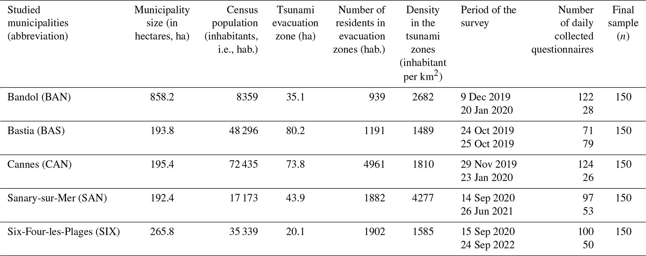
In a previous study, we mapped the tsunami evacuation zones at a fine scale for the 187 municipalities likely to be hit by a tsunami along the French Mediterranean coastlines (Carles et al., 2023). These zones correspond to all areas with an altitude of less than 5 m and a distance from the sea of less than 200 m along the river mouths. This distance is extended to 500 m from the mouth of the coastal rivers (Carles et al., 2023). Such deterministic mapping was chosen over a probabilistic model because of the different resolutions used in the previous models, the uncertainties of the sources, and the limitations of the catalogues. This choice, which is different in Italy or Spain, for example, has several advantages: (1) to have a common regional coverage with a precise resolution, (2) to take into account low-frequency scenarios (Mw>8 earthquake in Algeria, for example), and (3) to integrate the maximum sea level rise feared with global warming (Alhamid et al., 2022). The maximum height (5 m) remained consistent with the results of the probabilistic model (PTHA) tested and applied in Italy within the European project TSUMAPS NEAM (2018). Two main results were obtained along the French Mediterranean coastlines: (1) the evacuation zones cover 20 700 ha (hectares), and (2) according to national data, a tsunami may accommodate 163 000 inhabitants and 830 000 beach users during the peak summer period (Carles et al., 2013).
These zones were aggregated at the municipal level. Thus, we used these data to identify a set of municipalities presenting high densities of evacuation zones and to conduct appropriate face-to-face questionnaires. Our final selection (Table 1) allows us to select five municipalities with different demographic features. Cannes, with an area of approximately 1962 ha and a population of 72 435 inhabitants, is the most densely populated. Sanary-sur-Mer and Bastia are similar in size but less densely populated (i.e., 48 296 and 17 173 inhabitants per square kilometer). Six-Fours-les-Plages has the largest area (2658 ha) but a lower density than Bastia (Fig. 1). The choice of these communes was also motivated by the scientific knowledge accumulated over many years. Every year since 2016, Cannes has organized awareness-raising actions in which we participated, in particular during the World Tsunami Awareness Day (WTAD). Since 2021, Cannes has also been working with UNESCO to obtain the Tsunami Ready community recognition, which is expected at the end of 2023. In Bastia, a tsunami communication strategy has been in place since 2019, particularly following the real-life tsunami evacuation on 25 April 2015, when 20 terraces in seaside restaurants were evacuated by the authorities, who banned traffic on the seafront for almost an hour, even though it turned out to be a false alarm. Evacuations were planned and mapped out in Sanary-sur-Mer and Cannes but not in Bastia and Bandol. Choosing these five different municipalities, we aimed at observing differences in the tsunami hazard perception. This survey may also provide interesting results on the knowledge of alerts. In Cannes, seven sirens have been in place since 2019, covering about 78 % of the population in the 2 km audible range (Douvinet et al., 2021), and two sirens are located not far from the tsunami evacuation zone (Fig. 1). In addition, an SMS alert system can potentially inform more than 33 000 people (data from 2018). In contrast, there is only one siren in other municipalities. An SMS alert system also exists in Bandol. However, we do not have precise data on the number of registrations. Finally, the face-to-face areas were selected by combining the tsunami evacuation zones and the most densely populated areas to obtain a maximum number of questionnaires during the days of investigation.
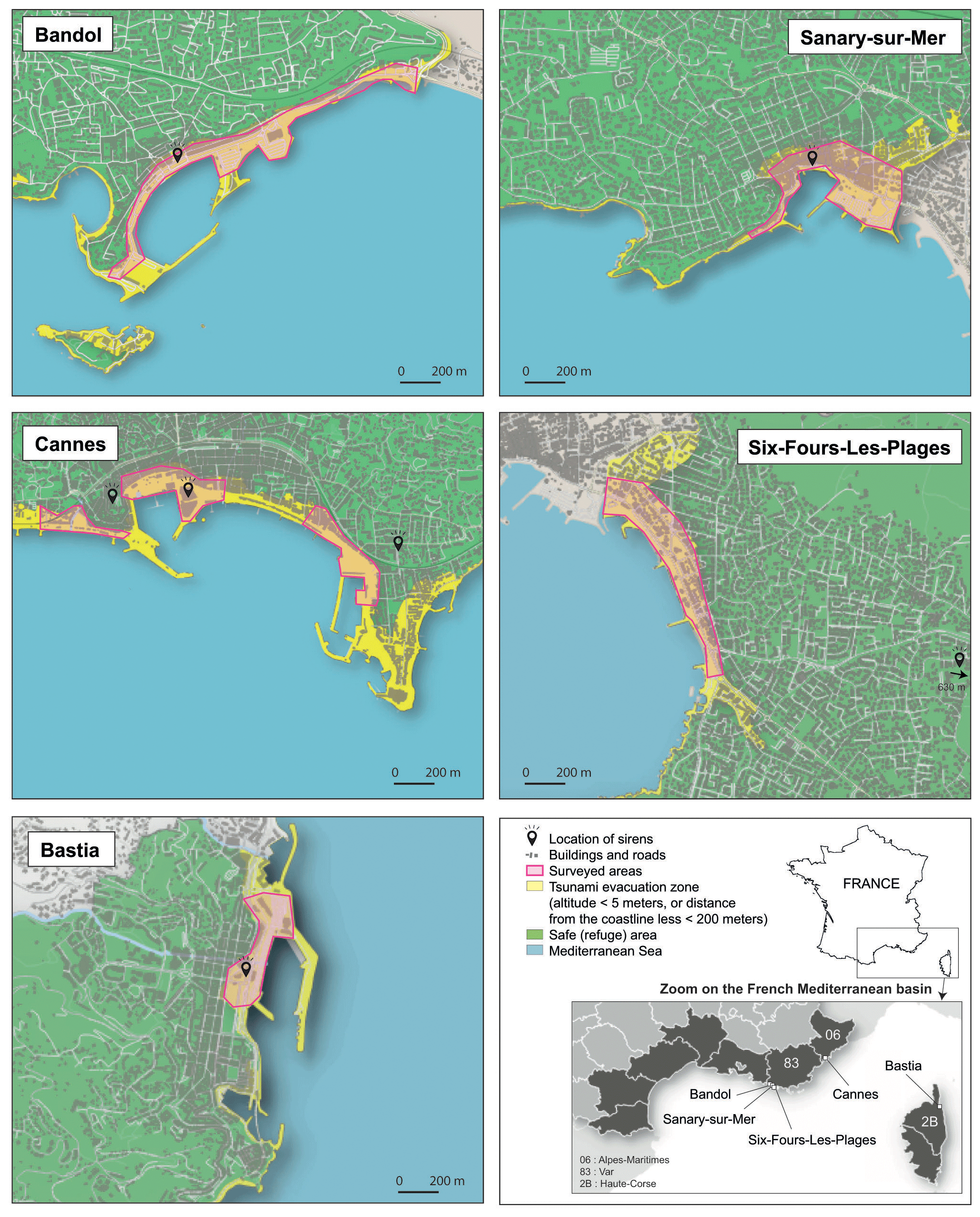
Figure 1Location of the surveyed areas, with sirens and the evacuation zones mapped at the fine scale.
Table 1Geographic and demographic characteristics of the five surveyed municipalities located along the French Mediterranean coastlines.
3.2 Data collection
3.2.1 Questionnaire
The questionnaire used in this study, administered in French (Appendix A), was adapted from related literature with similar objectives, in particular from the ASTARTE project (Liotard et al., 2017). The sample consisted of 5 sections and 17 questions, including 6 closed questions with yes/no options, 5 multiple-choice questions, and 6 open questions (Fig. 2). In Sect. 1, the questions were designed to get to know the respondents. In Sect. 2, we addressed the perception of hazards existing in the municipality and how they think they could be alerted for each one, using the classification of tools listed by Bopp and Douvinet (2022), who distinguished between the traditional tools (siren, TV, radio, door-to-door, loudspeaker) and modern tools (SMS, social media, internet). In Sect. 3, we defined five questions on tsunami hazard, in particular on the maximum levels that could withstand inundations during a tsunami (Q7). In Sect. 4, questions focused on the knowledge of tsunami alert and more especially on the intentions declared by the respondents if they receive an SMS alert message, with the protective measures recommended by UNESCO, like the following: “Tsunami alert! Leave the coast and seek higher ground!” (Q14, Fig. 2). This can also be explained by the fact that several municipalities have deployed SMS calling centers for a few years. Finally, Sect. 5 aimed to assess some socio-demographic variables. The questionnaire was designed with the help of two psychologists, who were invited to participate in March 2019. In addition, five students were asked to comment on any aspect of the questionnaire before the field administration. Based on their feedback, mobile phones were added to question Q15 and Q4, and Q6 and Q7 were slightly reformulated.
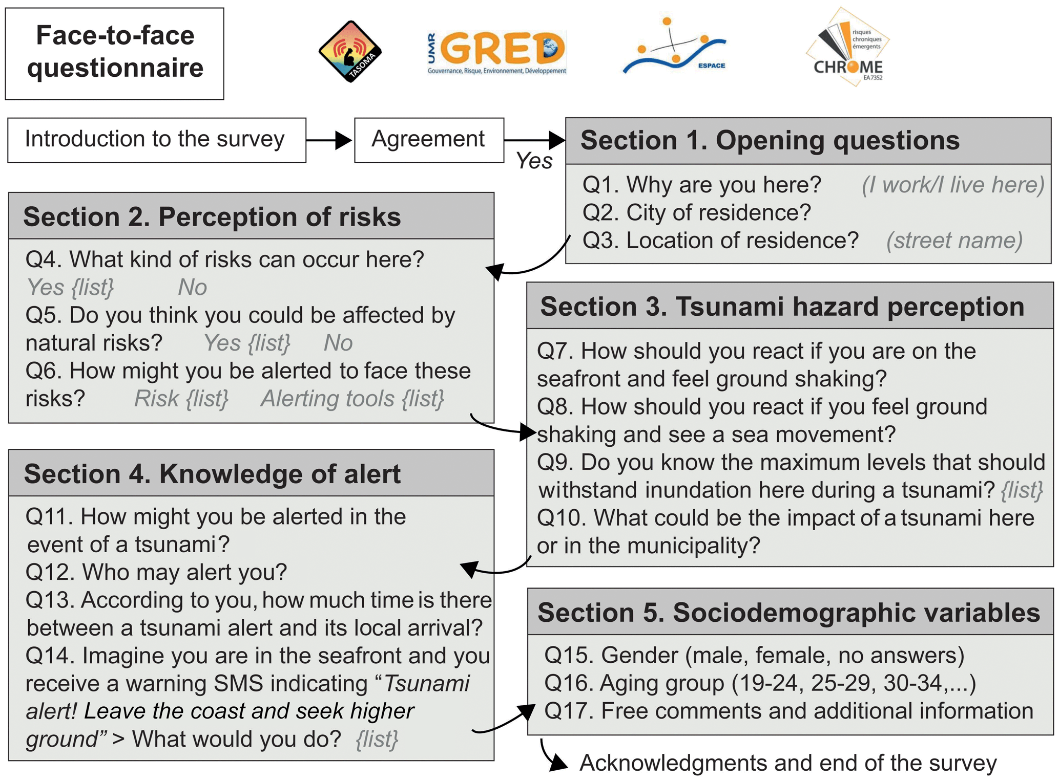
Figure 2The list of questions and handsets addressed to collect tsunami perception and knowledge of alerts.
3.2.2 Survey procedure
We invited residents or workers we met in the tsunami evacuation zones to participate in the survey. Once half of the expected number of responses had been collected (75 out of 150), a preliminary assessment was made between the interviewers to see if the expected age groups needed to be rebalanced. Due to the containment measures imposed by the COVID-19 pandemic in France, and in particular during three periods (17 March–11 May 2020; 20 October–15 December 2020; 3 April–3 May 2021), when movements were strictly prohibited, the survey was conducted on different days (Table 1) and took longer. We therefore decided to keep the face-to-face process to avoid disruptions in the survey, to ensure the presence of the same interviewers to administer the questions, and to guarantee that we had all the answers to the questions at the end of the questionnaire. A total of 86 people started to complete the questionnaire but stopped when we were dealing with the tsunamis. So, their answers were not kept. All respondents were also asked to give their consent to participate in this research, respecting the GDPR (General Data Protection Regulation) protocol that has been in place in France since 2015 (Fig. 2).
3.2.3 Profile's respondents
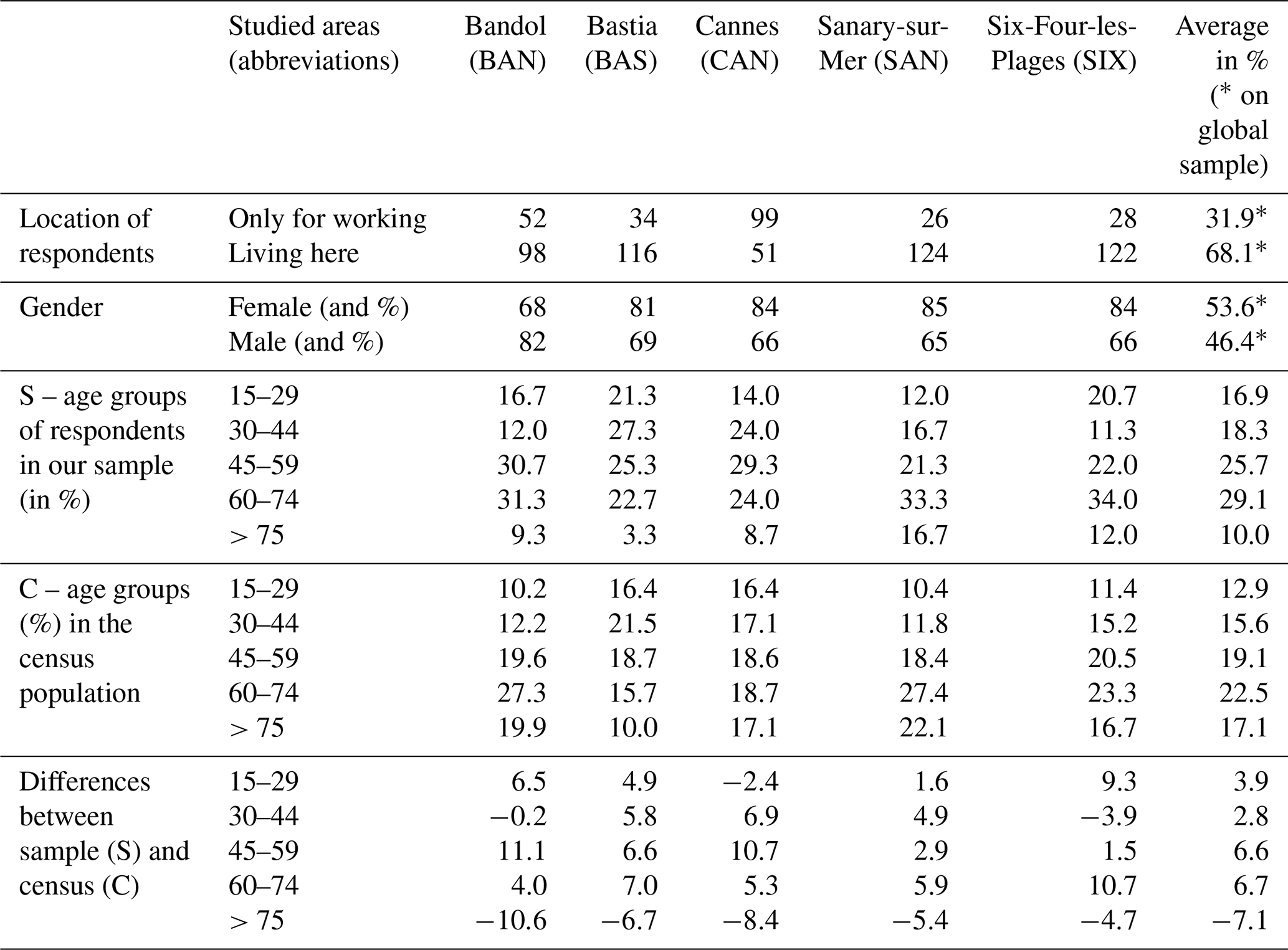
Table 2 shows the descriptive statistics for the profile sample. The 750 respondents were 53.6 % female and 46.4 % male, aged between 60 and 74 years (29.1 %), 45–59 years (25.7 %), 30–34 years (18.3 %), and 15–29 years (16.9 %), and the rest (10.0 %) were 75 years and over. A total of 68.1 % of respondents lived and 31.9 % worked in the areas surveyed. The global age group shows that the 15–74 group was over-represented, while the 75 group was under-represented. Specifically, the 45–59 age group was over-represented in Bandol and Cannes, and the 60–74 age group was over-represented in Six-Fours-les-Plages. These disparities are due to the fact that the 0–15 age group was not surveyed in accordance with French regulations, as well as the challenge of finding older people and persuading them to participate in a face-to-face questionnaire (Sun and Sun, 2019). A total of 34 of the 86 respondents who terminated the survey prematurely were over 75 years of age. These questionnaires were then deleted. While these biases are consistent with other questionnaires (Cerase et al., 2019; Cugliari et al., 2022; Ong et al., 2023), their impact is limited unless they are so severe as to attenuate the variances of the variables (Lindell and Perry, 2000).
Table 2Census demographics of the respondents who answered to the face-to-face questionnaire.
3.3 Data analysis
The 750 questionnaires were analyzed using SphinxOnline and RStudio to allow filtering and statistical analysis. Three approaches were carried out. First, a qualitative analysis was carried out to compare the average values obtained in each site. Figures summarize results by contrasting accepted (with a variation of green color ranges) and negative (with variation in the red color ranges) answers. Second, for each question, the chi-square method χ2 was used to statistically confirm trends in the collected data we detected. The age, gender, and residency status (residents or workers) were used as explanatory variables. When the null hypothesis (H0) was rejected (with p<0.001), the Cramer index (Ci) was calculated for measuring the strength of the independence relationship. Third, two multiple correspondence analyses (MCAs), one referring to the tsunami hazard perception (Sect. 3) and another to the knowledge of alerts (Sect. 4), were carried out. In addition, two HACs (i.e., hierarchical ascendant classifications) were conducted on the coordinates of the two previous MCAs to group the respondents based on the occurrence of declared answers. Once classifications were analyzed, we looked at the distribution of the respondents in each of the HACs and studied whether the municipalities joined the same profiles or not. If yes, a strong relationship between tsunami hazard perception and knowledge of alerts is proven. If not, then we analyze why there is any difference and provide a discussion in the last section.
Data collected for tsunami hazard perception (Sect. 3) and knowledge of alert (Sect. 4) were analyzed for the global sample and by comparing each municipality. We also statistically evaluated the relationship with socio-demographic variables (e.g., age, gender, residence status) in order to answer the four research hypotheses.
4.1 Tsunami hazard perception
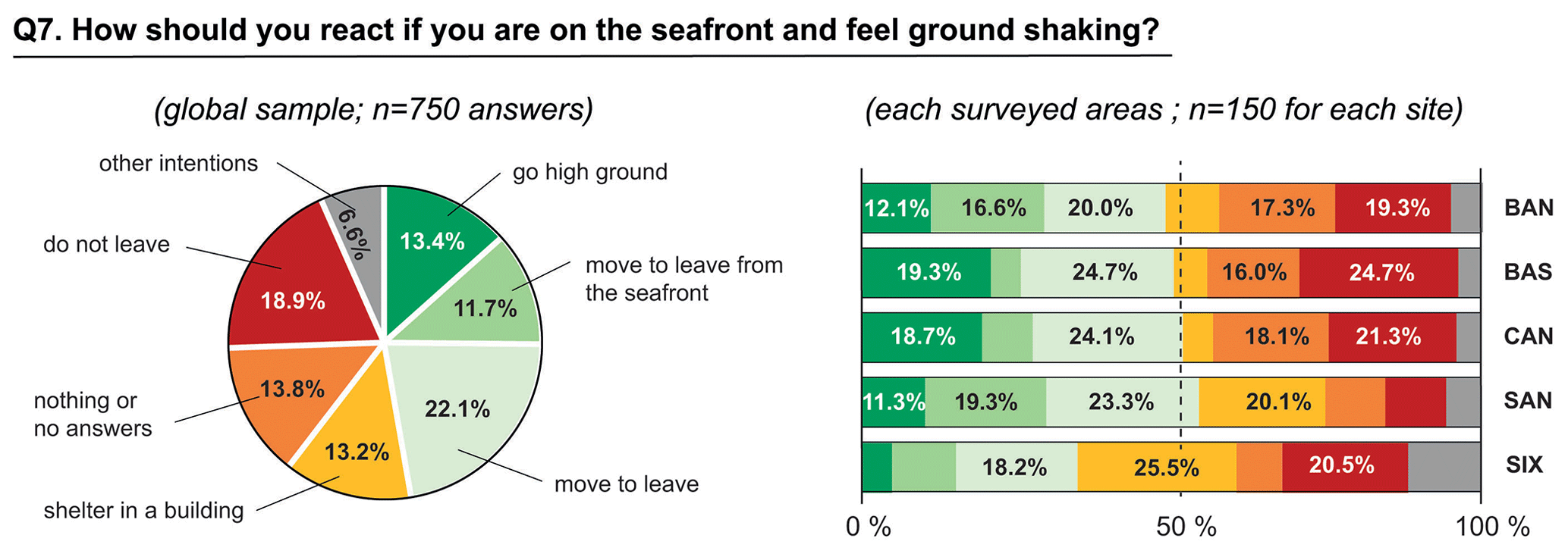
First, when the 750 respondents imagined being on the seafront and feeling the ground shake (Q7), 13.4 % said they would seek higher ground, 11.7 % would move away from the seafront, and 22.1 % would leave. Added together, these responses give a global rate of 47.2 % (Fig. 3). Then, only 47.2 % of respondents claim to be able to take appropriate protective actions. A total of 19.3 % of respondents in Sanary-sur-Mer said they would move, compared with only 4.2 % in Bastia. On the other hand, 13.2 % said they would take shelter in buildings, with high figures in Six-Fours-les-Plages (25.5 %) and Sanary-sur-Mer (20.1 %). A total of 18.9 % said they would not leave, 13.8 % did not know what they would do, and the remaining 6.6 % combined other answers (i.e., call for help, call friends, call the school, go to the beach, or go on a boat). The number of respondents who say they could take protective measures is not correlated with the number of respondents who do not know what to do and do not go. The χ2 test with age (χ2=53.22; p<0.001; Ci=0.13) shows that people aged 30–44 are more likely to take shelter, while those aged 45–59 are less likely to do so. People aged 75 and over are more likely to express the intention to stay in place, although they also show a tendency to be more likely to move away from the sea.
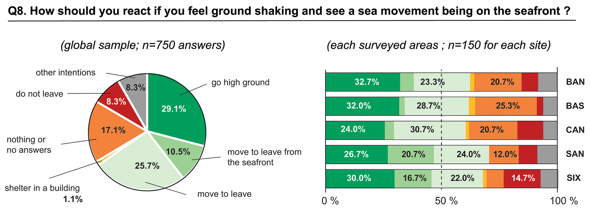
Related to the previous question, when respondents imagined that they felt the ground shaking and saw the sea moving along the seafront (Q8), 29.1 % said they would seek higher ground, 10.5 % would move away, and 25.7 % would leave. Also, these intentions give a global rate of correct answers of 65.3 % (compared to 47.2 % for Q9). The main difference is explained by the number of respondents who reported seeking higher ground (Fig. 4). In contrast, only 1.1 % reported taking shelter in buildings. A total of 17.1 % said they did not know what to do, and this rate was 25.3 % in Bastia, 20.1 % in Sanary-sur-Mer, and 20.7 % in Cannes, compared to only 12 % in Sanary-sur-Mer. It is interesting to note that 46.5 % associate a tsunami with ground tremors and sea movements, while 14.5 % refer to a meteorological event or an earthquake, and others (38.9 %) do not know what is happening. The χ2 test on location (χ2=79.91; p<0.001; Ci=0.16) confirms the high number of respondents who do not leave in Bastia and the higher values for respondents who move away from the seafront in Sanary-sur-Mer. The χ2 test with age (χ2=49.5; p<0.001; Ci=0.12) confirms that those aged 60–74 are the most likely to say that they would move away from the seafront, while those aged 75 and over are the most likely to not move away but are also the more likely to say that they take shelter. However, no relationship exists with gender or residence status.
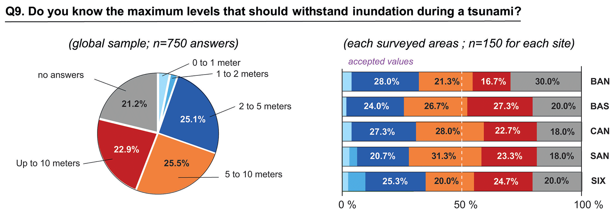
On the other hand, we analyzed the inundation heights declared by the respondents (Q9). The analysis reveals a strong misperception of possible run-up heights (Fig. 5). A total of 25.1 % of the respondents stated that a tsunami could generate heights between 2 and 5 m, with the highest rates of positive responses in Bandol (28 %) or Cannes (27.3 %) and the lowest in Sanary-sur-Mer (20.7 %). The number of correct responses, indicating values between 0 and 5 m, is 30.4 %, with variations between Bastia (26 %) and Six-Fours-les-Plages (35.3 %). On the other hand, the number of respondents who indicated heights of between 5 and 10 m (25.5 %) or more than 10 m (22.9 %) is significant. These two responses add up to an overall percentage of 48.4 %. When completing the questionnaire, many respondents recall the 2004 event and the media or photos they saw on TV and the internet. The number of respondents who did not mention altitude was high (21.2 %), particularly in Bandol (30 %). The χ2 test with location (χ2=49.5; p<0.001; Ci=0.13) shows that the number of respondents who indicated a maximum height of 1–2 m in Six-Fours-les-Plages is high, as is the number of “no answers” in Bandol. Relationships with gender, age group, or residence status were therefore not statistically proven.
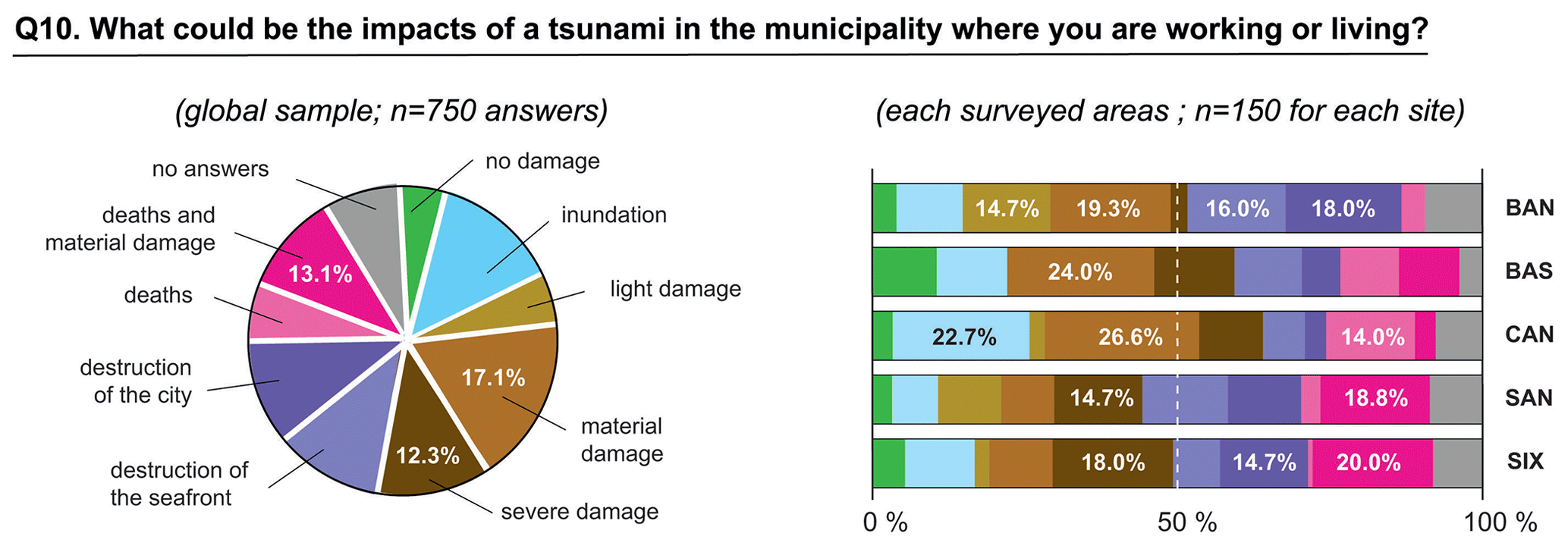
Respondents were also asked to imagine impacts of a tsunami in the area where they work or live (Q10). Four groups emerge when we classify terms reported for this open question. In one group, some respondents indicated that tsunamis might cause no damage or only minor flooding or damage. These responses totaled 24.1 %, with slight variations between the five surveyed municipalities (Fig. 6). Material and serious damage are declared by the second group, with cumulative percentages ranging from 22 % in Bandol to 38 % in Bastia. Destruction of the seafront or the town formed the third group. The percentage varies greatly, ranging from 10 % in Cannes to 34 % in Bandol. The last group declared that tsunamis may cause deaths and not systematically material damage. The number of respondents reporting this impact is higher in Sanary (18.8 %), Six-Four-les-Plages (20.0 %), and Cannes (17.1 %), where 14 % said that tsunamis can cause deaths without serious material damage. The χ2 test with age (χ2=56.58; p<0.001; Ci=0.17) confirms that the youngest age group (15–44 years) expected at least material damage, compared to the oldest, who expected little or no impact on coastlines. The post hoc analysis of the standardized results also shows that the observed frequencies for those aged 75 and over who expected no impact were significantly lower than expected.
4.2 Knowledge of alert
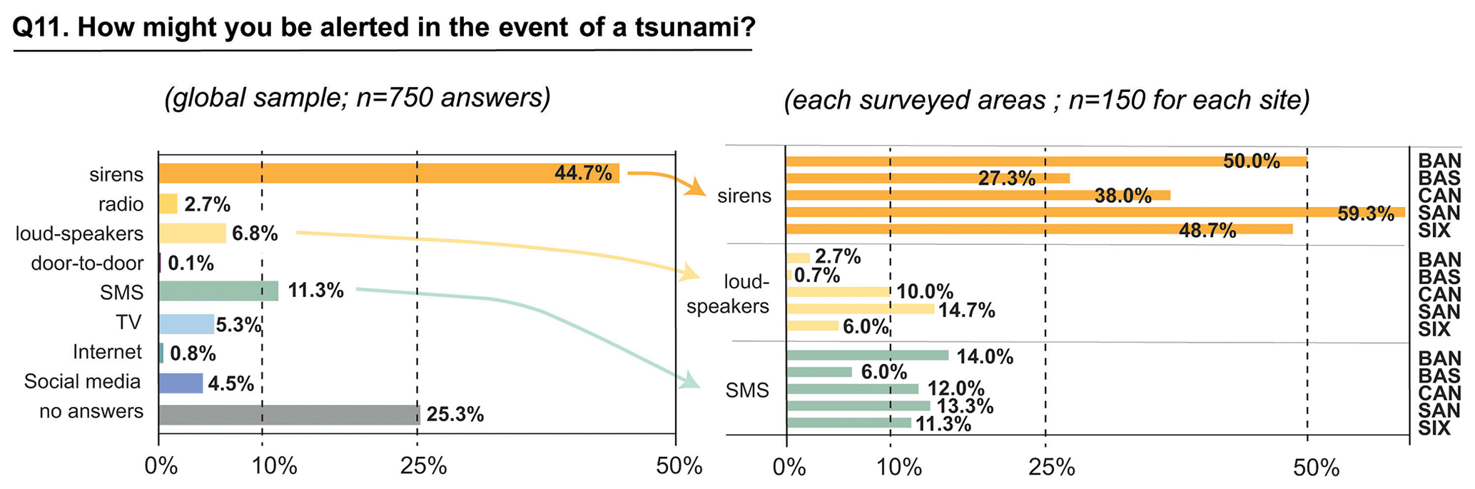
When we asked respondents how they would be alerted in the event of a tsunami (Q11), sirens emerged as the most alerting disseminators (Fig. 7). On average, 42.3 % of the respondents we interviewed in Cannes, Bastia, Sanary-sur-Mer, and Bandol answered correctly. Local differences appeared, as only 38 % of respondents identified the sirens in Cannes (while there are seven sirens). In Six-Fours-les-Plages, 48.7 % thought they could be alerted by sirens, although the siren is far from the tsunami evacuation zones. The second tool mentioned was SMS alert systems. The number of respondents in Cannes (10 %) and Sanary-sur-Mer (14.7 %) is higher than in Bandol, where it is only 2.7 %. In the other areas, people wrongly believe that they can be alerted by SMS. Loudspeakers received the highest number of responses in Sanary-sur-Mer (14.7 %) and Cannes (9.1 %), where these tools really exist, while the low rates in the other areas can be explained by their absence. TV (5.3 %), social media (4.5 %), and radio (2.7 %) all recorded low response rates. On the other hand, 25.3 % said they did not know how to be alerted. Interestingly, the χ2 test with location (χ2=130.5; p<0.001; Ci=0.28) statistically shows a high number of no answers and social media in Bastia but no relation with gender or residency status.
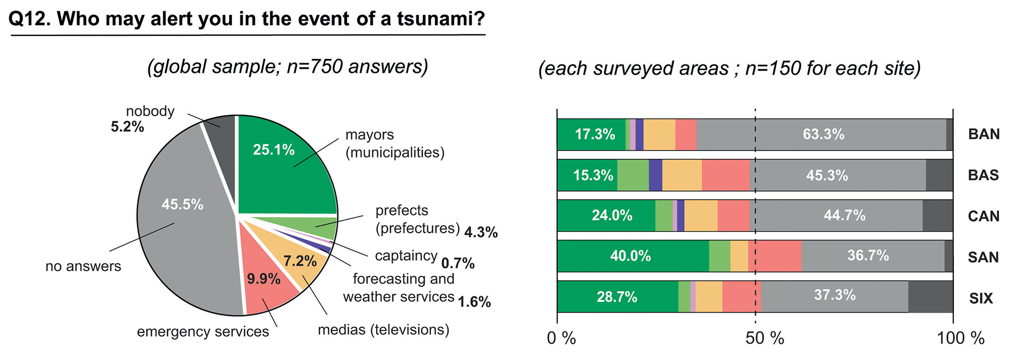
In relation to the previous question (Fig. 8), when respondents were asked who should alert them in the event of a tsunami (Q12), 45.5 % did not know who should alert them, and only 29.4 % correctly named mayors (25.1 %) and prefectures (4.3 %). The number of positive answers in Sanary-sur-Mer (40 %) is higher than in other areas. In contrast, 63.3 % of respondents did not know who could alert them in Bandol. On the other hand, 9.9 % wrongly believe that they will be alerted by the emergency services, 7.2 % by TV, 1.6 % directly by the Tsunami Alert Centre, and 5.9 % think that the alert may never be sent. These differences are statistically confirmed by the χ2 test with the location (χ2=98.1; p<0.001; Ci=0.25). However, there are no additional relationships with age (χ2=4.54; p>0.27), gender (χ2=1.45; p>0.36), or residence status (χ2=3.52; p>0.31).
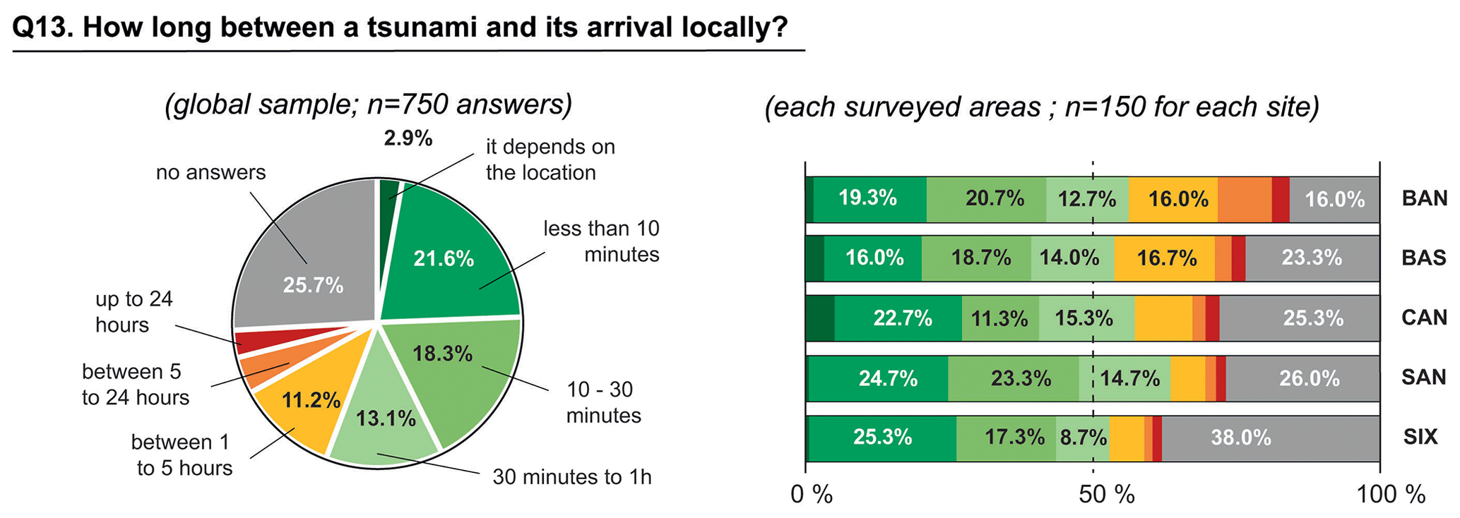
On the other hand, 55.9 % of respondents estimated the time between a tsunami alert and its arrival locally (Q13) to be less than 1 h (Fig. 9). A total of 21.6 % also estimated it to be less than 10 min and 18.3 % estimated it to be between 10 and 30 min. Interestingly, 2.9 % said they could not give an exact time, stating that this depended on the location of the earthquake or the speed of the tsunami waves. This can be considered satisfactory in view of the current state of the art. In Sanary-sur-Mer, the final rate of exact answers equals 63.4 %. On the other hand, 25.7 % of respondents were unable to answer this question, 7.4 % gave a time of more than 5 h in Bandol, and 9.3 % of respondents gave a time of between 5 and 24 h. The χ2 test on location (χ2=70.9; p<0.001; Ci=0.15) confirms the large differences described above. The χ2 test with age (χ2=74.81; p<0.001; Ci=0.16) shows that those aged 15–29 are more likely to say 1 to 5 h and 45–59 less than 10 min. Those aged 15–44 are also the least likely to say they do not know, in contrast to those aged 75 and over.
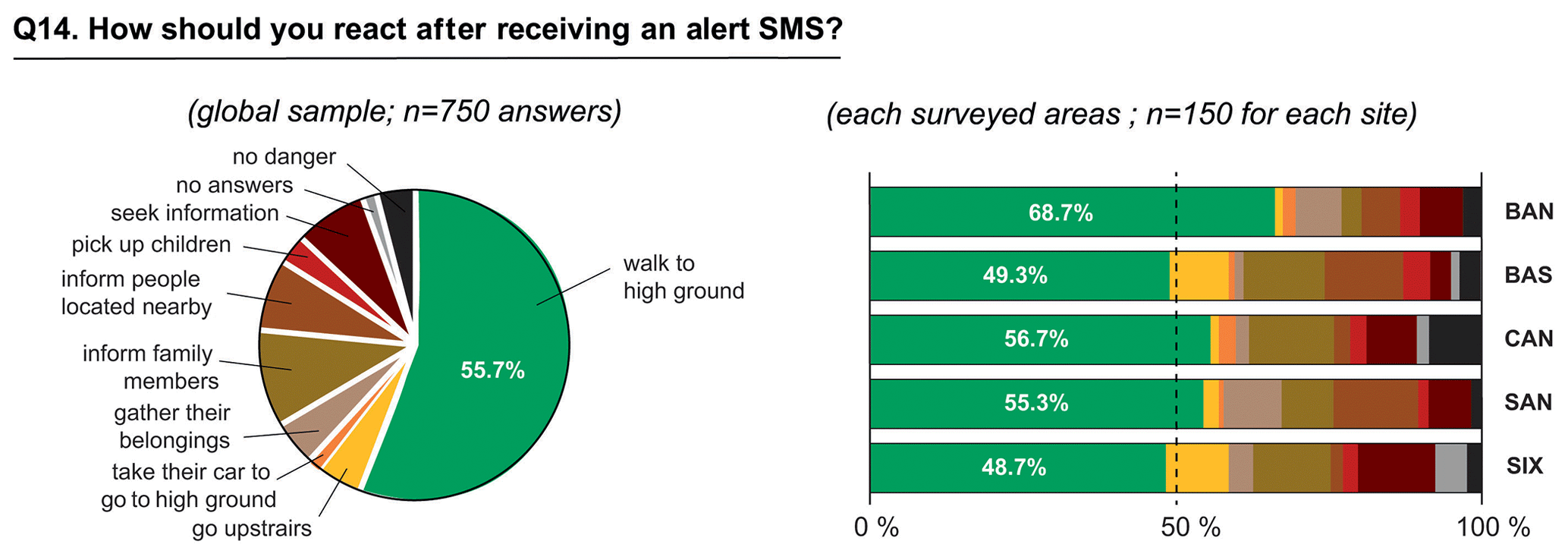
We finally asked respondents (Q14) how they thought they would react if they received an SMS warning message saying “Tsunami alert! Leave the coast and seek higher ground!”. A total of 55.7 % said they would immediately think of seeking higher ground, with values ranging from 49.3 % in Bastia to 68.7 % in Bandol (Fig. 10). However, before leaving, 10.1 % said they would take time to inform their family members, 7.5 % to inform people nearby, 7.5 % to get information to check the credibility of the SMS, 4.7 % to collect their belongings, 4.7 % to look for their car, and 3.1 % to collect their children. These responses represent a cumulative rate of 37.5 %. In addition, 4 % of the 750 respondents said they would stay where they were (8.7 % in Bastia), 1.7 % did not know what to do (4.7 % in Six-Fours-les-Plages), and 1.7 % would take shelter in a building (3.3 % in Cannes). This SMS message is therefore not sufficient to generate protective intentions in the event of a tsunami and is in line with previous studies (Cain et al., 2021; Smith et al., 2022). Surprisingly, the recommendation seek higher ground was not fully understood by some respondents, and the latter reported going upstairs (4.7 %) or using their car (1.3 %). The χ2 test with residence status (χ2=13.89; p<0.001; Ci=0.17) shows that respondents who work in the surveyed municipalities are less likely to evacuate immediately, compared to those who live there. However, the χ2 test cannot be used for variables such as gender, age group, and residential status.
4.3 Relation between tsunami hazard perception and knowledge of alert
This study continued by examining the possible relationships between tsunami hazard perception and knowledge of alert. To achieve this, a first MCA was realized using the rates of correct answers obtained for each question in Sect. 3. Of the total inertia of 1, 29.3 % is accounted for by F1 (i.e., the first axis), 20.4 % by F2, 19.1 % by F3, 16.9 % by F4, and 14.3 % by F5. Cumulatively, the first two axes account for 49.7 % of the total inertia. The rates of negative answers of respondents (Q8) when they felt the ground shaking and saw the abnormal sea movement (contr. = 0.19) and when (Q9) they estimated the water heights of a possible tsunami (contr. = 0.11) contribute most to F1. The rate of negative answers (Q9) contributes most to F2, with a clear association with the lack of identification of the tsunami (contr. = 0.08) in Q4. Respondents who gave a positive answer to Q8 (contr. = 0.18) but a negative answer to Q9 (contr. = 0.17) are grouped in F3. F4 includes the respondents who mentioned tsunamis as a risk in Q4 (contr. = 0.25) and gave positive answers to Q7, Q8, and Q9.
The hierarchical ascendant classification (HAC) carried out on the basis of the MCA coordinates and the analysis of the dendrogram allows us to identify four classes (Fig. 11). Group 1 includes most of the respondents who gave incorrect answers to Q8 (140 people out of a global sample of 255) and Q9 (141 out of 517) and who did not mention the term “tsunami” (143 out of 630). Group 2 consists of respondents who gave a good answer to Q9 (with 86 % of the total number of respondents who answered this question correctly) but who also did not mention the tsunami as a risk (196 people out of 630). A total of 44 % of this group also gave no correct answer to Q8. Group 3 consists of a large proportion of respondents who gave a correct answer to Q8 (291 out of 489) but who gave an incorrect answer to Q9 (291 out of 522). Finally, Group 4 consists exclusively of respondents who correctly perceived tsunami hazard (119 out of 119). A total of 75 % of the respondents showed proficiency in answering Q8, while 56 % showed proficiency in answering Q7. As a result, in Group 4, the respondents had a greater tendency to recognize the arrival of a tsunami and to take the appropriate protective actions.
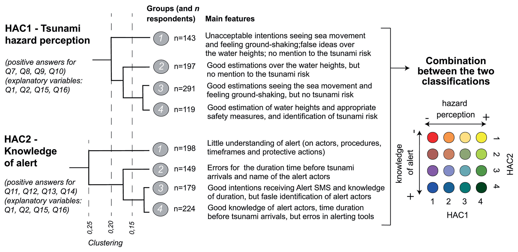
The total inertia of the second MCA (Fig. 11) gives the following results: F1 accounts for 30.9 %, F2 for 25.5 %, F3 for 22.5 %, and F4 for 21 %. The cumulative contribution of the first two axes is 56.4 % of the total inertia. The incorrect answers for alerting tools (Q11) as well as the time between alert and the arrival of the tsunami (Q13) contribute most to F1 (contr. = 0.2 and 0.17 respectively). The respondents who did not follow the instructions after receiving the SMS (Q14, contr. = 0.36) and who did not identify actors involved in the tsunami alert process (Q11, contr. = 0.29) contribute most to F2. F3 is derived from the contribution of Q13 (positive answers: contr. = 0.23; negative answers: contr. = 0.27), while Q14 mainly contributes to F4 (positive answers: contr. = 0.29; negative answers: contr. = 0.31).
The classification carried out with this second HAC also allows the identification of four classes (Fig. 11). Group 1 consists of respondents who answered Q14 incorrectly (198 people out of the total sample size of 287) and Q12 incorrectly (198 out of 526). In addition, a significant proportion of 59 % did not answer Q11 correctly (116 out of 366), while 56 % answered Q13 incorrectly (109 out of 353). This group includes respondents who have a slight understanding of the warnings. Group 2 includes only respondents who gave incorrect answers to Q13 (167 out of 397) and Q12 (149 out of 526), while they should apply the instructions when receiving the SMS (149 out of 463). Group 3 includes most of the respondents who successfully answered Q13 (179 out of 397) and Q14 (179 out of 463) but also those who did not answer Q12 correctly (179 out of 526). Finally, Group 4 includes 100 % of those who answered Q12 correctly (224 out of 224) and 59 % of those who answered Q11 correctly (133 out of 383). However, while most of the respondents in Group 4 showed accurate knowledge by answering both Q11 and Q12 correctly, it is worth noting that a significant proportion, 40.6 %, also gave an incorrect answer to Q13 (91 out of 367). While the first MCA allows the identification of a group in which all respondents have positive intentions (Group 4), this second MCA highlights a class (Group 1) that has, in contrast, a very poor understanding of alerts, in terms of actors, procedures, timeframes, and tools.
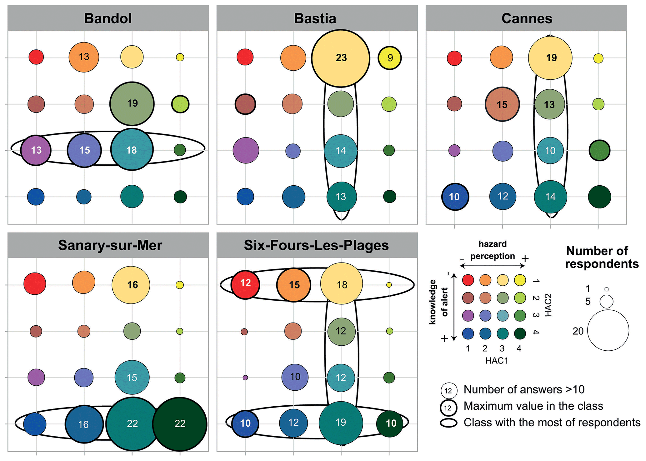
Combining the distribution of the 150 respondents in each classification finally allows us to have a synthetic overview for each of the municipalities, which we can then compare (Fig. 12). In Bandol, a great majority of respondents present an average level for tsunami hazard perception and knowledge of alerts. In Cannes, there is a difference in the number of respondents possessing a more accurate knowledge of alerts, which is approximately twice as much than in Bandol. In Bastia, the number of respondents with low hazard perception is the lowest among the surveyed areas. Six-Fours-les-Plages counts an equal number with a low- and high-tsunami-hazard-perception profile, while in Sanary-sur-Mer, the balance shifts markedly in favor of the respondents endowed with a further knowledge of alert (50 % of the respondents are in Group 4). Last but not least, those aged 75 and above are often joined in groups characterized by low perception and knowledge. It could be a problem due to their low capacity (Arimura et al., 2020; Hall et al., 2022), because most of them lived alone, and because they are less likely to be associated with disaster preparedness (Sun and Sun, 2019).
5.1 Limitations
Methodologically, the face-to-face questionnaire is likely to introduce biases. This non-probabilistic approach is based on the availability, geographical proximity, and willingness of participants to take part in a survey, rather than on well-defined statistical criteria (Cerase et al., 2019). Unfortunately, it does not guarantee the significance of the results (Etikan et al., 2016). The wording and order of questions can also play a role in the way respondents answer (Venkatesh and Davis, 1996). There is often a gap between declaration of intentions (i.e., what individuals say they know how to do and what to do) and how they should actually behave during real tsunamis or real alerts, as demonstrated in previous studies (e.g., Weiss et al., 2011; Cugliairi et al., 2022; Ong et al., 2023). The period over which we collected the 750 questionnaires is also debatable. In Cannes, a storm caused significant flooding on 23 September 2019 (i.e., 6 d before the first survey in this area), and sirens were activated, which may have affected the results. In Bastia where data were collected in October 2019, a false alarm for a tsunami occurred a few years ago in 2015, which probably changed the local people's awareness about this risk. However, data collected in this study allow us to answer the four initial hypotheses and open up discussions, especially when we compare the rate of correct answers with those calculated in other areas of the NEAMTWS region (Goeldner-Gianella et al., 2017; Lavigne et al., 2017; Cerase et al., 2019; Cugliari et al., 2022).
5.2 Implications for research
This study first confirms that, as other Mediterranean areas and in similar proportion, the perception of the tsunami hazard is low. As a relevant example, 23 % of respondents in our sample incorrectly stated that possible run-up heights could be more than 10 m, and this belief was closest to that reported in Heraklion, Greece (21 %), or Tangier, Morocco (19 %). Videos, images, or newspaper articles of catastrophic events such as the 2004 and 2011 events may explain this overestimation rather than a realistic understanding of the tsunami processes (Rafliana et al., 2022; Cugliari et al., 2022). On the other hand, 22 % of the respondents in our survey incorrectly stated that the time between a tsunami alert and its arrival could be less than 10 min, with a high proportion of the youngest age group, as proven in Heraklion (20 %).
However, this study also shown significant differences, particularly when we look at the rate of correct answers estimated for certain questions. The proportion of respondents who indicated that possible run-up heights may exceed 10 m is lower than in Italy (ranging from 31 % to 41 % in Cugliari et al., 2022); in Syracuse (34.5 %); or in Sinès, Portugal (46 % in Liotard et al., 2017). This result could be explained by the highest probability of violent earthquakes in Italy or Portugal (Cugliari et al., 2022) but also by the fact that no major and mediatized tsunami has happened before our data collection. On the other hand, the proportion of respondents who think that alerts may arrive between 10 and 30 min is lower in our study (18 %) than in Heraklion (45 %) or in Sinès (38 %). We also postulate that the alert is considered to be short or too long, with no intermediate duration (Courteau, 2017), but this idea needs to be certified in future surveys. Moreover, if the percentage of respondents who do not know the time before tsunami arrival (21 % in our study) is nearest in Tangier or in Syracuse (23 %), this is unfortunately higher than in Nice, Saint-Laurent-du-Var, or Villefranche-sur-Mer (14 %). No significant difference exists with the residency status and age, and we think here that the lack of a recurrent campaign of information could explain this higher rate of wrong answers. The proportion of respondents who react to seeing an abnormal sea movement and feeling the ground shaking in the seafront is also lower in our survey (48 % if we sum up the different protection actions) than in Sinès (91 %, Liotard et al., 2017). This may be explained by the fact that the interviewers never mentioned the term “tsunami” at the start of the questionnaire.
Knowledge of alert is also not satisfying. In this study, authorities responsible of the upward alert are identified by only 29.2 % of the respondents. The content of the SMS watch alert does not guarantee the appropriate reactions, as only 55.4 % of the respondents declare they would seek higher ground, even though it was clearly mentioned in the SMS message. Such an SMS can even push people into a more dangerous situation, as 9 % of the respondents declared they would stay in place. Results obtained in the ASTARTE project were quite different, as 11 % know who may alert the population, and 52 % declare they may evacuate or seek higher ground if they receive an SMS watch alert. Lack of alert campaigns, both on national and local level, and the limited local initiatives about sensitization on tsunami may explain this weak knowledge. In contrast, thanks to numerous campaigns on tsunamis carried out since 2016 in Norway, half of the respondents correctly mentioned the text message warning on their phones as a way to receive an alert without questioning it or searching other sources of information (Goeldner-Gianella et al., 2017). One way of increasing awareness of alerts would be to take advantage of the recent implementation of more modern alert solutions in France. Thus, since we carried out our study, a new alerting tool named FR-Alert was deployed in June 2022 in France using cell-broadcast technology (Bopp and Douvinet, 2021).
Another relevant finding in our survey is that most of the differences between respondents are explained by age, as opposed to the residency status or gender (RQ2). As people get older, they seem more likely to react passively to the risk of a tsunami (Arimura et al, 2020). In addition, higher age groups often tend to recognize subjective norms more than younger groups (Terumoto, 2022). In this study, we confirmed that those in the 75 years and above age group underestimate risk and alerts, confirming their vulnerability. Those in the youngest age group seem to have better perceptions, and it is encouraging as they represent the future generations (Hall et al., 2022). However, this differs with a recent study in Cascadia that found that age was not significantly associated with earthquake and tsunami perception (Chen et al., 2021). On the other hand, gender or residency status do not play a key role in this study, while females seem to be more likely to believe that they are susceptible to a tsunami in other studies (Hall et al., 2022).
5.3 Implications for practice
According to our results and the previous studies, there is a consistent effort to raise public awareness on tsunami hazard in the NEAMTWS region. By evaluating the tsunami hazard perception and knowledge of alert, we suggest the municipalities may further communicate and inform on tsunamis. Developments could also be designed to question new scientific fields, with regard to both hazard perception (e.g., the role and effects of social media, the influence of social groups) and knowledge of alert (e.g., people's receptivity to sirens or new cell-broadcast solutions). Such local knowledge can be shared with local authorities which can also find international support with UNESCO to organize events about tsunamis. The International Oceanographic Commission (ICG)/NEAMTWS has organized four regional tsunami exercises since 2012, and the NEAMWave23 is still planned. These exercises are opportunities to maintain a high operational readiness, practice response protocols, and guarantee that crucial communication lines function smoothly (Sorensen et al., 2012). Communities can also apply to the Tsunami Ready program to prepare to face a tsunami. Several communities are on their way to obtain this recognition soon in the NEAMTWS region (i.e., Cyprus, Egypt, Greece, Italy, Malta, Morocco, Portugal, Turkey, Israel, and France). In Cannes, evacuation itineraries are physically marked along several places (beach exits, promenades, harbor area, roads) and equipped by many loudspeakers. Trials or current exercises may improve the perception, but actions should be combined and repeated to increase both the tsunami and alert perceptions. In Cannes, the tsunami risk perception is slightly higher than in other areas, but reciprocity with knowledge of alert is missing.
This sample also questions the evacuation from the tsunami zone (Wei et al., 2017; Hall et al., 2022), defined as the single effective response that can lead to safety (Goto et al., 2012). In this survey, 7.8 % and 18.9 % of the respondents respectively declare they shelter in a building or they do not leave if they feel ground shaking on the seafront, and 9.8 % do not leave even if they see an abnormal sea movement. In this case, if people go upstairs and follow signposts into the buildings, these actions seem coherent, and the vertical evacuation could then be included in plans (Rafiana et al., 2022). However, respecting the current legislation in France, we have not considered these answers as positive because such vertical safe zones in buildings need to be accessible 24 h a day and 7 days a week, and they need to obey specific construction rules (i.e., earthquake resistance or the venue capacity). As planning a vertical evacuation is essential for low-lying areas subject to the risk of local tsunamis, we need to involve designating buildings and to clearly communicate which buildings can be used for this (Hall et al., 2022). And a systematic evacuation might not needed in these areas, as water heights are evaluated from 2 to 3 m and with a maximum of 5 m.
This study offered the opportunity to question both tsunami hazard perception and knowledge of alert along the French Mediterranean coastlines. Results confirmed the tendency to underestimate tsunami hazard perception, as only 30.4 % of the respondents correctly identified possible run-up heights, and 46.5 % claimed to be able to take appropriate protective actions if they feel ground shaking on the seafront. Knowledge of the alert process is also unsatisfying, as only 38.1 % of respondents correctly identified sirens as existing disseminators, and 29.4 % correctly named mayors or prefectures as the alert senders. However, 65 % declared they think of seeking higher ground or evacuating if they also see an abnormal sea movement, and 55.7 % said they would immediately think of going to higher ground when receiving a warning SMS. Age or location of respondents explain differences between the five municipalities – more so than gender or residency status. This differs from previous surveys carried out in other areas located in the North East Atlantic and the Mediterranean Tsunami Warning System (NEAMTWS) region, and this confirms the existence of local effects. More surprisingly, the respondents who well perceive the tsunami hazard are not those who have a good knowledge of alerts, and the awareness actions do not really impact the tsunami knowledge we evaluated. Also, the results of this study could help local authorities to develop future tsunami awareness actions and to determine more suitable strategies to be applied in the short term at local scales.
Interpreting reasons for explaining the local and site differences therefore remains challenging. Recent awareness initiatives and preparedness exercises in which authorities and, to some extent, the citizens of Sanary-sur-Mer participated could explain the high rate of correct responses for alerts. Nevertheless, it is peculiar that they stand out so much from the neighboring municipalities of Bandol and Six-Fours-les-Plages. Conversely, it is surprising that Cannes does not significantly distinguish itself from the others, due to the involvement of the municipality in raising awareness of tsunami risk since 2019. One could argue that conducting the surveys in 2019 was not sufficient to have an observable effect on the population's perceptions. On the other hand, the recent deployment of cell-broadcast (CB) alerts, since June 2022, offers a good opportunity to shorten the time for alert diffusion and increase the time for evacuation in the event of a regional tsunami in the French Mediterranean coastlines.
A1 Get to know the interviewee
-
Q1: Why are you here (name of the municipality)? (a) I work here; (b) I live there.
-
Q2: City of residence? Free comments.
-
Q3: Location of residence (street name)? Free comments.
A2 Perception of risk existing in your municipality
-
Q4: What kind of risks can occur here? (a) Yes {list}; (b) No.
-
Q5: Do you think you could be affected here by natural risks? (a) Yes (risk?) {list}; (b) No.
-
Q6: How might you be alerted to face these risks? (a) Risk {list}; (b) Way to receive alert: {list}.
A3 Tsunami hazard perception
-
Q7: How should you react if you are on the seafront and feel ground shaking? Free comments.
-
Q8: How should you react if you feel ground shaking and see a sea movement? Free comments.
-
Q9: Do you know the maximum levels that should withstand inundation here during a tsunami? {list} (a) 0–1 m; (b) 1–2 m; (c) 2–5 m; (d) 5–10 m; (e) 10 m; (f) I don't know.
-
Q10: What could be the impact of a tsunami here or the municipality? Free comments.
A4 Knowledge of alert
-
Q11: How might you be alerted in the event of a tsunami? Free comments.
-
Q12: Who may alert you? Free comments.
-
Q13: According to you, how much time is there between a tsunami alert and its local arrival? {list} (a) < 10 min; (b) 10–20 min; (c) 30 min–1 h; (d) 1–5 h; (e) 5–24 h; (f) > 24 h; (g) I don't know.
-
Q14: Imagine you are in the seafront and receive the following SMS: “Tsunami alert! Leave the coast and seek higher ground!”. What would you think to do first? {list} (a) I don't feel in danger, I am continuing my activities; (b) I immediately seek higher ground; (c) I verify the information; (d) I inform people around me; (e) I inform my family and my friends; (f) I gather my important belongings and evacuate my home/work/seaside; (g) I collect my kids at school first; (h) I try to go upstairs in the first building around me to shelter.
A5 Socio-demographic variables
-
Q15: What is your gender? {list} (a) Male; (b) Female; (c) Other; (d) I don't want to answer.
-
Q16: How old are you? {list} (a) 0–14 years; (b) 15–29 years; (c) 30–44 years; (d) 45–59 years; (e) 60–74 years; (f) > 75 years.
-
Q17: Do you have any questions or remarks, or do you need information on tsunamis? Free comments.
The dataset generated for the present study is not publicly available because the questionnaire has not yet been administered in all French coastal areas, and the data are being further analyzed by the research team. However, data are available from the corresponding author on reasonable request.
All authors contributed to the early stages of the manuscript with individual contributions from their respective research fields. Major contributions are listed as follows: early compilation of text – JD, NC, PF, and MP; introduction – JD, PF, NC, and MP; literature review – JD, PF, NC, and MP; methods and data – JD, NC, PF, and MP; results – JD, PF, NC, and MP; discussions – JD, MP, PF, and NC; internal review – all authors.
The contact author has declared that none of the authors has any competing interests.
Publisher's note: Copernicus Publications remains neutral with regard to jurisdictional claims made in the text, published maps, institutional affiliations, or any other geographical representation in this paper. While Copernicus Publications makes every effort to include appropriate place names, the final responsibility lies with the authors.
We sincerely acknowledge all the respondents, the 10 students who helped us to build the face-to-face questionnaire, and the two English native speakers who re-read the text. We also thank the anonymous reviewers for helpful suggestions that improved the manuscript.
This article was based upon works carried out within the TASOMA project, supported by the INSHS (i.e., Institut National des Sciences Humaines et Sociales) and the IRD (i.e., Institut de Recherche pour le Développement) over 2 years (2019–2021). Results obtained in this project are available at https://storymaps.arcgis.com/stories/caabb106dd684f67ab758e3ec14f2ad5 (last access: 24 February 2024).
This paper was edited by Rachid Omira and reviewed by two anonymous referees.
Akbar, Z., Suryaratri, R. D., Tri, Y., Gumelar, G., and Ariyani, M.: Disaster risk perception and household disaster preparedness: Lesson learned from tsunami in banten, IOP Conf. Ser. Earth Environ. Sci., 448, 012099, https://doi.org/10.1088/1755-1315/448/1/012099, 2020.
Alhamid, A. K., Akiyama, M., Ishibashi, H., Aoki, K., Koshimura, S., and Frangopol, D. M.: Framework for probabilistic tsunami hazard assessment considering the effects of sea-level rise due to climate change, Struct. Safe., 94, 102152, https://doi.org/10.1016/j.strusafe.2021.102152, 2022.
Arias, J. P., Bronfman, N. C., Cisternas, P. C., Repetto, P. B.: Hazard proximity and risk perception of tsunamis in coastal cities: Are people able to identify their risk?, PLOS ONE, 12, e0186455, https://doi.org/10.1371/journal.pone.0186455, 2017.
Arimura, M., Vinh Ha, T., Kimura, N., and Asada, T.: Evacuation awareness and behavior in the event of a tsunami in an aging society: An experience from the 2018 Hokkaido Eastern Iburi earthquake, Safe. Sci., 131, 104906, https://doi.org/10.1016/j.ssci.2020.104906, 2020.
Atwater, B. F., Cisternas, M. V., Bourgeois, J., Dudley, W. C., Hendley, J. W., and Stauffer, P. H.: Surviving tsunami – Lessons from Chile, Hawaii and Japan, US Geological Survey Circular 1187, US Geological Survey, 1–19, https://pubs.usgs.gov/circ/c1187/c1187.pdf (last access: 18 September 2023), 1999.
Basquin, E., El Baz, A., Sainte-Marie, J., Rabaute, A., Thomas, M., Lafuerza, S., El M'rini, A., Mercier, D., d'Acremont, E., Bristeau, M.-O., and Creach, A.: Evaluation of tsunami inundation in the plain of Martil (north Morocco): Comparison of four inundation estimation methods, Nat. Hazards Res., 3, 494–507, https://doi.org/10.1016/j.nhres.2023.06.002, 2023.
Bean, H., Sutton, J., Liu, B. F., Madden, S., Wood, M. M., and Mileti, D. S.: The study of mobile public warning messages: A research review & agenda, Rev. Commun., 15, 60–80, https://doi.org/10.1080/15358593.2015.1014402, 2015.
Bird, D. and Dominey-Howes, D.: Testing the use of a `questionnaire survey instrument' to investigate public perceptions of tsunami hazard and risk in Sydney, Australia, Nat. Hazards, 45, 99–122, https://doi.org/10.1007/s11069-007-9172-8, 2008.
Bopp, E. and Douvinet, J.: Alerting people prioritizing territories over technologies. A design framework for local decision makers in France, Appl. Geogr., 146, 102769, https://doi.org/10.1016/j.apgeog.2022.102769, 2022.
Bopp, E., Gisclard, B., Weiss, K., Martin, G., and Douvinet, J.: How to improve alert systems: The technical, human, environmental and structural aspects, Aust. J. Emerg. Manage., 36, 67–75, 2021.
Bopp, E., Douvinet, J., Carles, N., Foulquier, P., and Péroche, M.: Spatial (in)accuracy of cell broadcast alerts in urban context: feedback from the April 2023 Cannes tsunami trial, Comput. Environ. Urban Syst., 107, 102055, https://doi.org/10.1016/j.compenvurbsys.2023.102055, 2024.
Boschetti, L., Ioualalen, M., Nemati, F., Grilli S., Dressa J.-X., and Larroque C.: Tsunami intensity scale based on wave amplitude and current applied to the French Riviera: the case study of local seismicity, Nat. Hazards, 102, 219–248, https://doi.org/10.1007/s11069-020-03921-0, 2020.
Buylova, A., Chen, C., Cramer, L. A.,Wang, H., and Cox, D. T.: Household risk perceptions and evacuation intentions in earthquake and tsunami in a Cascadia Subduction Zone, Int. J. Disast. Risk Reduct., 44, 101442, https://doi.org/10.1016/j.ijdrr.2019.101442, 2020.
Cain, L., Herovic, E., and Wombacher, K.: “You are here”: Assessing the inclusion of maps in a campus emergency alert system, J. Conting. Crisis Manage., 29, 332–340, https://doi.org/10.1111/1468-5973.12358, 2021.
Carles, N., Péroche, M., Douvinet, J., and Foulquier, P.: Estimation du nombre d'individus à évacuer en cas de tsunami à l'échelle du littoral méditerranéen français, Méditerranée, Revue géographique des pays méditerranéens/Journal of Mediterranean geography, https://doi.org/10.4000/mediterranee.14431, in press, 2023.
Cerase, A., Crescimbene, M., La Longa, F., and Amato, A.: Tsunami risk perception in southern Italy: First evidence from a sample survey, Nat. Hazards Earth Syst. Sci., 19, 2887–2904, https://doi.org/10.5194/nhess-19-2887-2019, 2019.
Cheff, I., Nistor, I., and Palermo, D.: Pedestrian evacuation modelling of a Canadian west coast community from a near-field tsunami event, Nat. Hazards, 98, 229–249, https://doi.org/10.1007/s11069-018-3487-5, 2019.
Chen, C., Lindell, M. K., and Wang, H.: Tsunami preparedness and resilience in the Cascadia Subduction Zone: A multistage model of expected evacuation decisions and mode choice, Int. J. Disast. Risk Reduct., 59, 102244, https://doi.org/10.1016/j.ijdrr.2021.102244, 2021.
Chen, C., Wang, H., Lindell, M. K., Jung, M. C., and Siam, M. R. K.: Tsunami preparedness and resilience: Evacuation logistics and time estimations, Transport. Res. Pt. D, 109, 103324, https://doi.org/10.1016/j.trd.2022.103324, 2022.
Chen, T., Gil-Garcia, J. R., Burke, G., and Werthmuller, D.: Enabling Effective Emergency Message Writing through Technology: A Participatory Design Approach, in: Proceedings EGOV-CeDeM-ePart conference, 5–7 September 2023, Budapest, Hungary, https://ceur-ws.org/Vol-3449/paper22.pdf (last access: 16 November 2022), 2023.
Chen, X. and Zhan, F. B.: Agent-based modelling and simulation of urban evacuation: relative effectiveness of simultaneous and staged evacuation strategies, J. Operat. Res. Soc., 59, 25–33, https://doi.org/10.1057/palgrave.jors.2602321, 2008.
Choi, B.-H., Cho, Y.-S., and Yoon, S. B.: Tsunami research in Korea, Nat. Hazards, 84, 437–454, https://doi.org/10.1007/s11069-016-2439-1, 2016.
Courteau, R.: L'évaluation et la prévention du risque du tsunami sur les côtes françaises en métropole et outre-mer, Office parlementaire d'évaluation des choix scientifiques et technologiques, Rapport au Sénat, 117, p. 171, https://www.senat.fr/notice-rapport/2007/r07-117-notice.html (last access: 24 February 2024), 2017.
Courteau, R.: La prévention et l'alerte du risque de tsunami sur les côtes françaises, compte rendu de l'audition publique du 7 février 2019 et de la présentation des conclusions du 21 mars 2019 – Rapport au Sénat et à l'Assemblée Nationale, p. 64, http://www.senat.fr/rap/r18-399/r18-3992.html (last access: 14 October 2023), 2019.
Cugliari, L., Cerase, A., and Amato, A.: Tsunami risk perception, a state-of-the-art review with a focus in the NEAM region, Front. Earth Sci., 10, 995536, https://doi.org/10.3389/feart.2022.995536, 2022.
Dash, N. and Gladwin, H.: Evacuation decision making and behavioral responses: individual and household, Nat. Hazards Rev., 8, 69–77, https://doi.org/10.1061/(ASCE)1527-6988(2007)8:3(69), 2007.
Dohi, Y., Okumura, Y., Koyama, M., and Kiyono, J.: Evacuee generation simulation of the 2011 Tohoku tsunami in Kadonowaki, Ishinomaki, J. Jpn. Soc. Civ. Eng. Ser. A1, 71, 823–831, https://doi.org/10.2208/jscejseee.71.i_823, 2015.
Douvinet, J., Serra-Llobet, A., Bopp, E., and Kondolf, M.: Are sirens effective tools to alert the population in France?, Nat. Hazards Earth Syst. Sci., 21, 2899–2920, https://doi.org/10.5194/nhess-21-2899-2021, 2021.
Etikan, I., Musa, S. A., and Alkassim, R. S.: Comparison of convenience sampling and purposive sampling, Am. J. Theor. Appl. Stat., 5, 1–4, https://doi.org/10.11648/j.ajtas.20160501.11, 2016.
Eva, C. and Rabinovich, A. B.: The February 23, 1887 tsunami recorded on the Ligurian Coast, western Mediterranean, Geophys. Res. Lett., 24, 2211–2214, https://doi.org/10.1029/97GL02110, 1997.
Fakhruddin, B., Clark, H., Robinson, L., and Hieber-Girardet, L.: Should I stay or should I go now? Why risk communication is the critical component in disaster risk reduction, Progr. Disast. Sci., 8, 100139, https://doi.org/10.1016/j.pdisas.2020.100139, 2020.
Fathianpour, A., Evans, B., Jelodar, M. B., and Wilkinson, S.: Tsunami evacuation modelling via micro-simulation model, Progr. Disast. Sci., 17, 100277, https://doi.org/10.1016/j.pdisas.2023.100277, 2023.
Filippini, A. G., Pedreros, R., Lemoine, A., Stepanian, A. and Barbier, C.: Caractérisation de l'impact des tsunamis d'origine sismique sur le littoral du département des Alpes-Maritimes: sources en mer Ligure et dans la marge maghrébine, Rapport Final BRGM/RP-70278-FR, p. 187, https://www.haliotis2-concertation.fr/files/etude-brgm-des-tsunamis-alpes-maritimes-rapport-final (last access: 12 February 2023), 2020.
Geist, E. L. and Parsons, T.: Probabilistic Analysis of Tsunami Hazards, Nat. Hazards, 37, 277–314, https://doi.org/10.1007/s11069-005-4646-z, 2006.
Goeldner-Gianella, L., Grancher, D., Robertsen, Ø., Anselme, B., Brunstein, D., and Lavigne, F.: Perception of the risk of tsunami in a context of high-level risk assessment and management: the case of the fjord Lyngen in Norway, Geoenvironment. Disast., 4, 1–15, https://doi.org/10.1186/s40677-017-0068-y, 2017.
Goff, J. and Cain, G.: Tsunami databases: The problems of acceptance and absence, Geoforum, 76, 114–117, https://doi.org/10.1016/j.geoforum.2016.09.005, 2016.
Goto, Y., Affan, M., Agussabti, Nurdin, Y., Yuliana, D. K., and Ardiansyah: Tsunami Evacuation Simulation for Disaster Education and City Planning, J. Disast. Res., 7, 92–101, 2012.
Gravina, T., Nicola, M., Luca, F., and Pierfrancesco, C.: Tsunami risk perception along the tyrrhenian coasts of southern Italy: The case of Marsili volcano, Nat. Hazards, 97, 437–454, https://doi.org/10.1007/s11069-019-03652-x, 2019.
Grothmann, T. and Reusswig, F.: People at Risk of Flooding: Why Some Residents Take Precautionary Action While Others Do Not, Nat. Hazards, 38, 101–120, https://doi.org/10.1007/s11069-005-8604-6, 2006.
Hall, S., Emmett, C., Cope, A., Harris, R., Setiadi, G. D., Meservy, W., and Berrett, B.: Tsunami knowledge, information sources, and evacuation intentions among tourists in Bali, Indonesia, J. Coast. Conserv., 23, 505–519, https://doi.org/10.1007/s11852-019-00679-x, 2019.
Hall S., Sloan-Aagard C., Harris R., Emmett C., Prasetyadi C., Petterson J., Cope A., and Hamson Cox M.: Perceptions of tsunami susceptibility and self-efficacy among adolescents in Indonesia: The influence of gender, religion, location, age, hazard information source, and past experience, Int. J. Disast. Risk Reduct., 79, 103151, https://doi.org/10.1016/j.ijdrr.2022.103151, 2022.
Kellens, W., Terpstra, T., and De Maeyer, P.: Perception and communication of flood risks: a systematic review of empirical research, Risk Anal., 33, 24–49, https://doi.org/10.1111/j.1539-6924.2012.01844.x, 2013.
Kurita, T., Arakida, M., and Colombage, S. R.: Regional characteristics of tsunami risk perception among the tsunami affected countries in the Indian Ocean, J. Nat. Disast. Sci., 29, 29–38, https://doi.org/10.2328/jnds.29.29, 2007.
Lachman, R., Tatsuoka, M., and Bonk, W. J.: Human Behavior during the Tsunami of May 1960: Research on the Hawaiian disaster explores the consequences of an ambiguous warning system, Science, 133, 1405–1409, https://doi.org/10.1126/science.133.3462.1405, 1961.
Lavigne, F., Quernez, R., Fressard, M., Brunstein, D., Grancher, D., Goeldner-Gianella, L., Burnel, M., Liotard, A., Plattard, O., Leone, F., Gherardi, M., Péroche, M., Aguirre Ayerbe, I., Zaniboni, F., El Mouraoua, A., Benchekroun, S., Dogulu, N., Kalaycioglu, S., Duzgun, S., Yalciner, A. C., Kanoglu, U., Papadopoulos, G. A., Baptista, M.-A., and Omira, R.: ASTARTE Report: D.9.36 – Large scale accessibility mapping and evacuation simulations using GIS tools and Multi-Agent Systems. Internal report of the FP7 Project (FP7-ENV2013 6.4-3) – Project number: 603839/2013, https://astarte-project.eu/deliverables.html (last access: 22 March 2020), 2017.
Lechowska, E.: What determines flood risk perception? A review of factors of flood risk perception and relations between its basic elements, Nat. Hazards, 94, 1341–1366, https://doi.org/10.1007/s11069-018-3480-z, 2018.
Leone, F., Lavigne, F., Paris, R., Denain, J. C., and Vinet, F.: A spatial analysis of the December 26th, 2004 tsunami-induced damages: Lessons learned for a better risk assessment integrating buildings vulnerability, Appl. Geogr., 31, 363–375, https://doi.org/10.1016/j.apgeog.2010.07.009, 2011.
Lindell, M. K. and Perry, R. W.: Household Adjustment to Earthquake Hazard: A Review of Research, Environ. Behav., 32, 461–501, https://doi.org/10.1177/00139160021972621, 2000.
Lindell, M. K. and Perry, R. W.: The Protective Action Decision Model: Theoretical Modifications and Additional Evidence: The Protective Action Decision Model, Risk Anal., 32, 616–632, https://doi.org/10.1111/j.1539-6924.2011.01647.x, 2012.
Lindell, M. K., Prater, C. S., Gregg, C. E., Apatu, E. J., Huang, S. K., and Wu, H. C.: Households' immediate responses to the 2009 American Samoa Earthquake and Tsunami, Int. J. Disast. Risk Reduct., 12, 328–340, https://doi.org/10.1016/j.ijdrr.2015.03.003, 2015.
Liotard, A., Goeldner-Gianella, L., Grancher, D., and Lavigne, F.: La perception du risque tsunami à Sines, Portugal: de l'importance du paysage dans la perception sociale du risque, Finisterra, 105, 29–47, https://doi.org/10.18055/finis8561, 2017.
Loewenstein, G. F., Weber, E. U., Hsee, C. K., and Welch, N.: Risk as Feelings, Psycholog. Bull., 127, 267–286, https://doi.org/10.1037/0033-2909.127.2.267, 2001.
Lorito, S., Tiberti, M. M., Basili, R., Piatanesi, A., and Valensise, G.: Earthquake-generated tsunamis in the Mediterranean Sea: Scenarios of potential threats to Southern Italy, J. Geophys. Res.-Solid, 113, B01301, https://doi.org/10.1029/2007JB004943, 2008.
Maramai, A., Brizuela, B., and Graziani, L.: The Euro-Mediterranean Tsunami Catalogue, INGV, https://doi.org/10.4401/ag-6437, 2014.
Mas, E., Koshimura, S., Imamura, F., Suppasri, A., Muhari, A., and Adriano, B.: Recent Advances in Agent-Based Tsunami Evacuation Simulations: Case Studies in Indonesia, Thailand, Japan and Peru, Pure Appl. Geophys., 172, 3409–3424, https://doi.org/10.1007/s00024-015-1105-y, 2015.
Masina, M., Archetti, R., Besio, G., and Lamberti, A.: Tsunami taxonomy and detection from recent Mediterranean tide gauge data, Coast. Eng., 127, 145–169, https://doi.org/10.1016/j.coastaleng.2017.06.007, 2017.
Mileti, D. S. and Sorensen, J. H.: Communication of emergency public warnings: A social science perspective and state-of-the-art assessment, ORNL – Oak Ridge National Lab., Oak Ridge, TN, USA, https://doi.org/10.2172/6137387, 1990.
Murakami, H., Takimoto, K., and Pomonis, A.: Tsunami evacuation process and human loss distribution in the 2011 Great East Japan Earthquake-A case study of Natori city, Miyagi prefecture, in: 15th World Conference on Earthquake Engineering, 5 May 2012, Lisboa, 1–10, https://www.iitk.ac.in/nicee/wcee/article/WCEE2012_1587.pdf (last access: 18 March 2023), 2012.
Ong, A. K. S., Prasetyo, Y. T., Kusonwattana, P., Yuduang, N., Persada, S. F., Nadlifatin, R., Cahigas, M. M. L., Chuenyindee, T., and Thana, K.: Factors affecting the intention to prepare for tsunami in Thailand, Ocean Coast. Manage., 233, 106464, https://doi.org/10.1016/j.ocecoaman.2022.106464, 2023.
Papadopoulos, G. A., Gràcia, E., Urgeles, R., Sallares, V., De Martini, P. M., Pantosti, D., González, M., Yalciner, A. C., Mascle, J., Sakellariou, D., Salamon, A., Tinti, S., Karastathis, V., Fokaefs, A., Camerlenghi, A., Novikova, T., and Papageorgiou, A.: Historical and pre-historical tsunamis in the Mediterranean and its connected seas: Geological signatures, generation mechanisms and coastal impacts, Mar. Geol., 354, 81–109, https://doi.org/10.1016/j.margeo.2014.04.014, 2014.
Papageordiou, A., Tsimi, C., Orfanogiannaki, K., Papadopoulos, G., Sachpazi, M., Lavigne, F., and Grancher, D.: Tsunami Questionnaire Survey in Heraklion Test Site, Crete island, Greece, Oral presentation for the FP7 session, https://www.gein.noa.gr/metsz/presentations/DAY_1/SESSION_3/Papageorgiou.pdf (last access: 18 March 2023), 2015
Péroche, M.: La gestion de crise tsunami dans la Caraïbe: contribution géographique aux dispositifs d'alerte et d'évacuation des populations, Doctoral Dissertation, Montpellier 3, https://www.theses.fr/2016MON30042 (last access : 12 January 2021), 2016.
Rafliana, I., Jalayer, F., Cerase, A., Cugliari, L., Baiguera, M., Salmanidou, D., Necmioğlu, Ö., Ayerbe, I. A., Lorito, S., Fraser, S., Løvholt, F., Babeyko, A., Salgado-Gálvez, M. A., Selva, J., De Risi, R., Sørensen, M. B., Behrens, J., Aniel-Quiroga, I., Del Zoppo, M., Belliazzi, S., Pranantyo, I. R., Amato, A., and Hancilar, U.: Tsunami risk communication and management: Contemporary gaps and challenges, Int. J. Disast. Risk Reduct., 102771, https://doi.org/10.1016/j.ijdrr.2021.102771, 2022.
Sahal, A.: Le risque tsunami en France: contributions méthodologiques pour une évaluation intégrée par scénarios de risque, PhD thesis, Université Panthéon-Sorbonne-Paris I, p. 348, https://theses.hal.science/tel-00651617v2 (last access: 7 May 2021), 2011.
Scheer, S. J., Varela, V., and Eftychidis, G.: A generic framework for tsunami evacuation planning, Phys. Chem. Earth Pt. A/B/C, 49, 79–91, https://doi.org/10.1016/j.pce.2011.12.001, 2012.
Schindelé, F., Gailler, A., Hébert, H., Loevenbruck, A., Gutierrez, E., Monnier, A., Roudil, P., Reymond, D., and Rivera, L.: Implementation and Challenges of the Tsunami Warning System in the Western Mediterranean, Pure Appl. Geophys., 172, 821–833, https://doi.org/10.1007/s00024-014-0950-4, 2015.
Slovic, P., Finucane, M. L., Peters, E., and MacGregor, D. G.: Risk as Analysis and Risk as Feelings: Some Thoughtsabout Affect, Reason, Risk, and Rationality, Risk Anal., 24, 311–322, https://doi.org/10.1111/j.0272-4332.2004.00433.x, 2004.
Smith, K. R., Grant, S., and Thomas, R. E.: Testing the public's response to receiving severe flood warnings using simulated cell broadcast, Nat. Hazards, 112, 1611–1631, https://doi.org/10.1007/s11069-022-05241-x, 2022.
Sorensen, M. B., Spada, M., Babeyko, A., Weimer, S., and Grunthal, G.: Probabilistic tsunami hazard in the Mediterranean Sea, J. Geophys. Res.-Solid, 117, B01305, https://doi.org/10.1029/2010JB008169, 2012.
Sun, Y. and Sun, J.: Perception, preparedness, and response to tsunami risks in an aging society: Evidence from Japan, Safe. Sci., 118, 466–474, https://doi.org/10.1016/j.ssci.2019.05.060, 2019.
Sutton, J. and Woods, C.: Tsunami Warning Message Interpretation and Sense Making: Focus Group Insights, Weather Clim. Soc., 8, 389–398, https://doi.org/10.1175/WCAS-D-15-0067.1, 2016.
Sutton, J., Vos, S. C., Wood, M. M., and Turner, M.: Designing effective tsunami messages: examining the role of short messages and fear in warning response, Weather Clim. Soc., 10, 75–87, https://doi.org/10.1175/WCAS-D-17-0032.1, 2018.
Sutton, J., Wood, M. M., Croucha, S., and Waugha, N.: Public perceptions of U.S. earthquake early warning post-alert messages: Findings from focus groups and interviews, Int. J. Disast. Risk Reduct., 84, 103488, https://doi.org/10.1016/j.ijdrr.2022.103488, 2023.
Terrier, M., Monfort D., Lambert, J., Le Roy, S., Pedreros, R. and Sedan, O.: Method for Evaluating Vulnerability to Tsunamis of low-to-medium intensity: Application to the French Côte d'Azur, J. Tsunami Soc. Int., 32, 77–95, 2013.
Terumoto, K.: Tourism workers' perceptions of supporting tourists' evacuation in emergency situations, Int. J. Disast. Risk Reduct., 77, 103091, https://doi.org/10.1016/j.ijdrr.2022.103091, 2022.
Tinti, S., Armigliato, A., Pagnoni, G., and Zaniboni, F.: Scenarios of giant tsunamis of tectonic origin in the Mediterranean, J. Earthq. Technol., 42, 171–188, 2005.
Tonini, R., Di Manna, P., Lorito, S., Selva, J., Volpe, M., Romano, F., Basili, R., Brizuela, B., Castro, M. J., de la Asunción, M., Di Bucci, D., Dolce, M., Garcia, A., Gibbons, S. J., Glimsdal, S., González-Vida, J. M., Løvholt, F., Macías, J., Piatanesi, A., Pizzimenti, L., Sánchez-Linares, C., and Vittori, E.: Testing Tsunami Inundation Maps for Evacuation Planning in Italy, Front. Earth Sci., 9, 628061, https://doi.org/10.3389/feart.2021.628061, 2021.
Turchi, A., Di Traglia, F., Gentile, R., Fornaciai, A., Zetti, I., and Fanti, R.: Relative seismic and tsunami risk assessment for Stromboli Island (Italy), Int. J. Disast. Risk Reduct., 76, 103002, https://doi.org/10.1016/j.ijdrr.2022.103002, 2022.
UNESCO-IOC: Ten years of the the north-eastern atlantic, the mediterranean and connected seas tsunami warning and mitigation system (NEAMTWS) – accomplishments and challenges in preparing for the next tsunami, edited by: Guymer, T. and Santoro, F., Paris, Information Document 1340, UNESCO, https://unesdoc.unesco.org/ark:/48223/pf0000247393 (last access: 12 January 2021), 2017.
Venkatesh, V. and Davis, F. D.: A Model of the Antecedents of Perceived Ease of Use: Development and Test, Decis. Sci., 27, 451–481, https://doi.org/10.1111/j.1540-5915.1996.tb00860.x, 1996.
Wachinger, G., Renn, O., Begg, C., and Kuhlicke, C.: The Risk Perception Paradox – Implications for Governance and Communication of Natural Hazards, Risk Anal., 33, 1049–1065, https://doi.org/10.1111/j.1539-6924.2012.01942.x, 2013.
Wei, H.-L., Wu, H.-C., Lindell, M. K., Prater, C. S., Shiroshita, H., Johnston, D. M., and Becker, J. S.: Assessment of households' responses to the tsunami threat: A comparative study of Japan and New Zealand, Int. J. Disast. Risk Reduct., 25, 274–282, https://doi.org/10.1016/j.ijdrr.2017.09.011, 2017.
Weiss, K., Girandola, F., and Colbeau-Justin, L.: Les comportements de protection face au risque naturel: de la résistance à l'engagement, Pratiques Psychologiques, 17, 251–262, https://doi.org/10.1016/j.prps.2010.02.002, 2011.
Wood, M. C., Mileti, D., Bean, H., Liu, F. B., Sutton, J., and Madden, S.: Milling and public Warnings, Environ. Behav., 50, 535–566, https://doi.org/10.1177/0013916517709561, 2017.
Yoo, C. W., Lee, J., Yoo, C., and Xiao, N.: Coping behaviors in short message service (SMS)-based disaster alert systems: From the lens of protection motivation theory as elaboration likelihood, Inform. Manage., 58, 103454, https://doi.org/10.1016/j.im.2021.103454, 2021.