the Creative Commons Attribution 4.0 License.
the Creative Commons Attribution 4.0 License.
 | 09 Oct 2024
A brief history of tsunamis in the Vanuatu Arc
Bernard Pelletier
The archipelagos of Vanuatu and the eastern Solomon Islands, scattered over 1500 km along the Vanuatu Arc, include dozens of inhabited volcanic islands exposed to many natural hazards that impact their populations more or less severely. Due to the location of these islands on a subduction interface known as the Vanuatu subduction zone, tsunamis triggered by earthquakes, volcanic eruptions, and landslides locally, regionally, and in the far field represent a permanent threat. If catalogues already list tsunamis that have occurred in the Vanuatu Arc, they were not exclusively focusing on this region. This study goes further in the listing of tsunamis reported and/or recorded in the Vanuatu Arc, analysing existing catalogues, historical documents, and sea-level data from the five coastal tide gauges located in Vanuatu at Port Vila (Efate), Luganville (Espiritu Santo), Litzlitz (Malekula), and Lenakel (Tanna) and in the eastern Solomon Islands province at Lata (Ndende). It allows the identification of 100 tsunamis since 1863, 15 of them showing wave amplitude and/or run-up height of more than 1 m and 8 between 0.3 and 1 m. While some tsunamis are known to have occurred in the past, information about the wave amplitude or potential run-up is sometime lost (15 events). Also, tsunamis reported in neighbouring islands like New Caledonia but not reported or recorded in the Vanuatu Arc are discussed, as well as debated events or events with no known origin(s).
- Article
(2518 KB) - Full-text XML
-
Supplement
(362 KB) - BibTeX
- EndNote


1.1 Tectonic context
Located in the south-west Pacific region, the Vanuatu subduction zone (called VSZ hereafter) and its associated Vanuatu Arc (previously known as the New Hebrides Arc) belong to the Pacific Ring of Fire and result from the convergence between the Australian and Pacific plates. The Vanuatu Arc extends over 1500 km and includes the islands of Vanuatu (65 inhabited islands over a total of ∼ 83) but also includes in its southern part the uninhabited Matthew and Hunter islands and in its northern part most of the islands of the easternmost province of the Solomon Islands (also known as Temotu province and formerly known as the Santa Cruz Islands province; Fig. 1). Due to the morphology of the VSZ and to several microplate boundaries at the rear of the VSZ in the north Fiji Basin (NFB in Fig. 1), the arc can be divided into four segments, and the rate of convergence at the trench varies along the arc from 35 mm yr−1 in the central segment, 48 mm yr−1 in the south-easternmost segment (around Matthew and Hunter islands), 90 to 120 mm yr−1 in the southern segment to a maximum of 160 mm yr−1 in the northern segment (Pelletier et al., 1998; Calmant et al., 2003; Fig. 1).
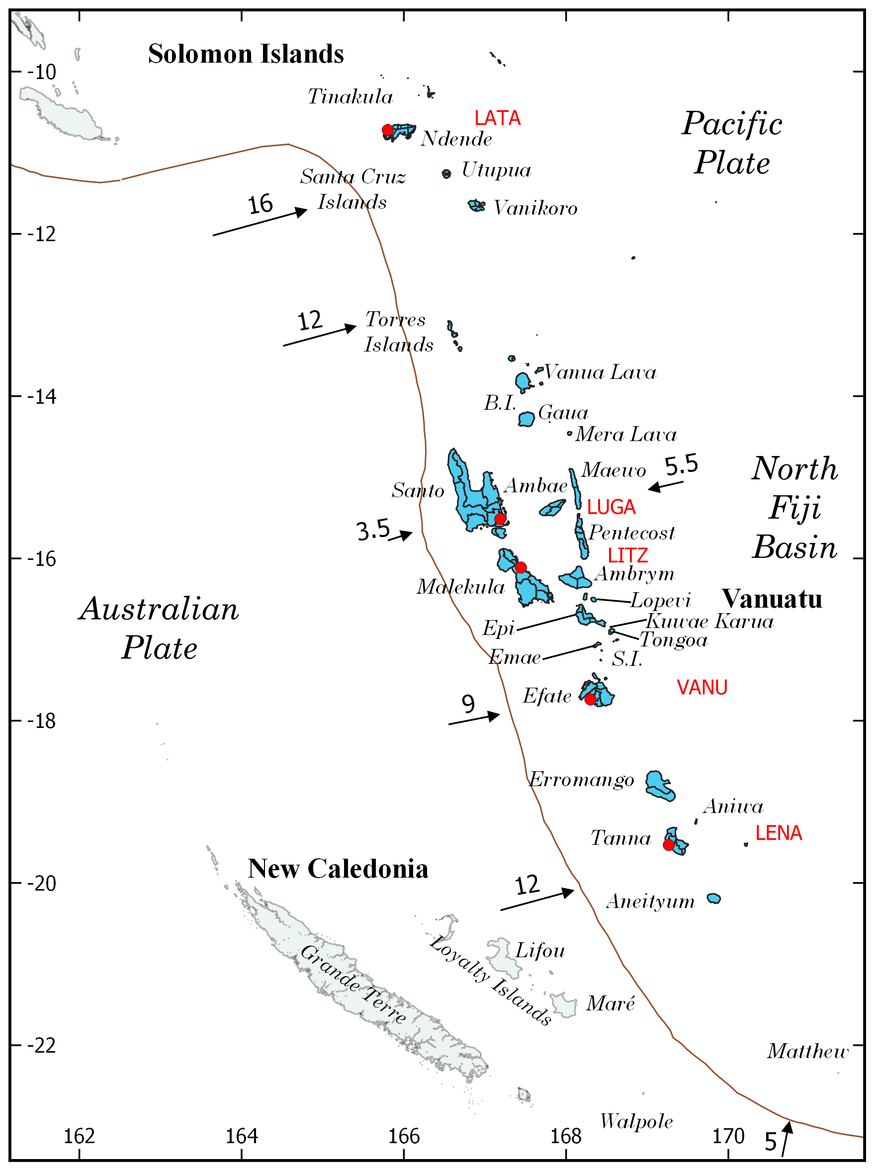
Figure 1The Vanuatu Arc at the boundary between the Australian and the Pacific tectonic plates. The convergence rates are symbolized by the black arrows (values from Calmant et al., 2003, are indicated in centimetres per year). The five coastal tide gauges are symbolized by red circles and their respective name given in red.
In the central part of the Vanuatu Arc, the islands are located along three lines or ranges parallel to the subduction trench (Carney and MacFarlane, 1982). The closest line to the trench, i.e. the western range, is the oldest volcanic line and contains Early to Middle Miocene volcanic series outcroppings in Malekula in the south, in Espiritu Santo, and in the Torres Islands in the far north. The middle line, i.e. the central range, is the most recent and extends all along the arc; it is composed of Plio–Quaternary volcanic rocks and active volcanoes from Matthew and Hunter islands in the south to Tinakula Island (Solomon Islands) in the north, through Aneityum, Tanna, Erromango, part of Efate, the Shepherd Islands, part of Epi, Lopevi, Paama, Ambrym, Ambae, Gaua, the Banks Islands, and then Vanikoro, Utupua, and the Santa Cruz Islands (Solomon Islands). The furthest line from the trench, i.e. the eastern range, is composed of Mio–Pliocene volcanic series outcroppings in Pentecost and Maewo islands in the north. These three lines of islands are the result of complex processes associated with the convergence history between the Australian and Pacific plates, including subduction polarity reversal. The islands of the western and eastern ranges and some of the islands in the central range exhibit coral reef terraces due to the uplift of the overriding plate (Taylor, 1992).
1.2 Human occupation and remnants of history
In 2003, the Teouma Lapita site was discovered in Efate Island, central Vanuatu (Bedford et al., 2004). Further investigations revealed that this is the oldest Lapita site in the whole western Pacific Ocean, with dating methods proving that people have occupied it since ca. 3000 cal BP (Bedford et al., 2006, 2007; Petchey et al., 2014). This estimated date has been more recently confirmed through DNA analyses of bones from the Teouma burial site: Vanuatu has been occupied by humans who travelled from Asia for ca. 3000 years (Skoglund et al., 2016). The first Europeans, led by the Portuguese explorer Pedro Fernandez De Quiros, discovered the archipelago in 1606 (and named it Iles St Esprit), but effective sparse settlement occurred only from 1768 when the French explorer Louis Antoine de Bougainville re-discovered these islands, soon followed by James Cook (in 1774), who mapped the archipelago and named it New Hebrides, in reference to the Scottish islands (Aldrich, 1993; Woodward, 2014). Some settlers from both France and England have lived in these islands since then, without one of the two countries claiming sovereignty. It was only in 1906 that they decided to establish a framework for joint Anglo–French management (condominium), which lasted until the independence of the Republic of Vanuatu in July 1980. The lack of written history from the native people's side and the very recent occupation by Europeans has led to the fact that the potential written history of Vanuatu, mainly by missionaries, began only ∼ 150 years ago and with it, the potential information related to tsunamis.
In the Solomon Islands, human occupation is believed to have begun much earlier in history, ca. 30 000–40 000 years ago during the Pleistocene (Friedlaender et al., 2002; Walter and Sheppard, 2009). However, the south-easternmost group of islands of the Solomon Archipelago, the so-called Santa Cruz Islands, were probably colonized by the first Lapita settlers only ca. 3000 years ago according to DNA analysis of the population (Friedlaender et al., 2002) and archaeology, including radiocarbon dating (Green, 1991; Kirch and Swift, 2017). The diversity of cultures and indigenous languages (63 different languages reported by Tryon and Hackman, 1983) in the archipelago makes the task of establishing a chronology of occupation complex. The only certainty is that the first Europeans who reached the Santa Cruz Islands were led by the Spanish explorer Álvaro de Mendaña de Neira in 1568. Navigators, especially whalers, travelled within this region only from the late 1700s to early 1800s, and the first missionaries had contact with coastal people from 1845, settling in 1898 with the foundation of a Roman Catholic mission (Hilliard, 1974). The Melanesian Mission was established in the eastern Outer Islands in 1849 (Tryon and Hackman, 1983). In this region, the settlement of Europeans is generally associated with written reports of natural phenomena, including earthquakes, volcanic eruptions, and tsunamis, which are not found before their arrival. For information, Tryon and Hackman (1983) indicate that the Solomon Islands government did not provide public education until 1945, which means that before then education was therefore limited to that provided by the church.
However, as in other islands in the Pacific region, “kastom” stories related to natural disasters exist in the traditional oral knowledge in Vanuatu and probably also in the eastern Solomon Islands. Geological evidence and oral history of tsunamis in Vanuatu have been reported by Goff et al. (2008), who related a collection of kastom stories about tsunamis and volcanic eruptions from villages in Efate, Epi, and Tongoa.
1.3 Tsunami catalogues and previous works on tsunamis in the Vanuatu Arc
Event catalogues, whether they collect information about tsunamis, volcanic eruptions, landslides, or other disasters, are a crucial step in studying natural hazards. In fact, hazard assessment needs reliable historical data to validate the models used for building evacuation maps, land use planning, etc. Several methodologies exist for building tsunami catalogues, three of them being the most common. The first one, and probably the one most commonly applied throughout the world, consists of investigating historical documents (including reports, journal articles, drawings, paintings, etc.) preserved in archives, as well as collecting testimonies from people (directly from the people themselves or reporting what someone else told the interviewed person about oral tradition, for instance, which is very common in the Pacific islands). The second one depends on the availability of oceanographic or sea-level data: the installation of tide gauges or, recently, tsunami coastal gauges and Deep-ocean Assessment and Reporting of Tsunami (DART) stations provides scientists and risk managers with direct and reliable observations and/or records of tsunamis waves, associated with critical values like wave amplitude, periodicity, polarity, frequency content, etc. The third methodology relies onto the sedimentological archives of tsunamis: when impacting the coast, tsunami waves are sometimes able to bring marine material onshore, which is eventually deposited afterwards. If the environment allows their conservation, typically in swamps or depressed areas showing a high rate of sedimentation, then these sediments can be preserved over millennia. Their analysis requires caution because, for example, small tsunami-related deposits can easily be confused with other marine submersion deposits like those brought by a storm or strong long-period swells (e.g. Shanmugam, 2012; Costa et al., 2018), or bioturbation can destroy the sedimentary structures (e.g. Spiske et al., 2020).
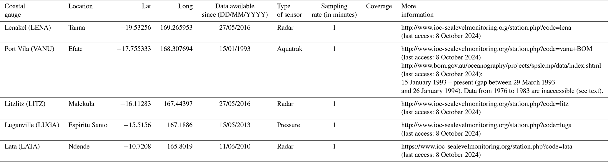
In Vanuatu and the eastern Solomon Islands, the limited written history (∼ 150 years) associated with the very recent and limited number of only five coastal gauges – four in Vanuatu, located in Port Vila (Efate) since 1977, then in Luganville (Espiritu Santo) in 1993 and more recently in Lenakel (Tanna) and Litzlitz (Malekula) in 1996, and one in Lata (Ndende, eastern Solomon Islands province) since 2010 (see details in Table 1) – leads to a very short and incomplete history of tsunamis, the largest of which could have return periods of hundreds to thousands of years. In addition, tsunamis triggered by landslides or volcanic eruptions are known to sometimes have a very limited impact zone and would not be recorded on gauges located tens to hundreds of kilometres away from their sources.
Table 1Coastal sea-level gauges in the Vanuatu Arc: location, start date of data availability, type of sensor, and link to the dataset (data from VLIZ/IOC, 2024, and the Australian Bureau of Meteorology, BOM: http://www.bom.gov.au/oceanography/projects/spslcmp/data/index.shtml, last access: 8 October 2024).
Although Vanuatu and the eastern Solomon Islands are located on a major subduction zone and thus are potentially subjected to tsunamis triggered by earthquakes, volcanic eruptions, and submarine landslides, there is almost no work on paleo-tsunamis based on tsunami deposits except the one from Goff et al. (2008) on Efate, Epi, and Tongoa, mainly focused on addressing the possible tsunami of the Kuwae eruption in the mid-15th century and the present-day study by a CNRS–IRD–Clermont Auvergne University (Clermont-Ferrand) team organized in June 2023 on Efate, Tanna, and Aneityum that was mainly focused on the predecessors of the 1875 and 1878 major events.
Previous work on historical tsunami catalogues in the Vanuatu Arc region includes that of Soloviev and Go (1974) on the western shore of the Pacific Ocean for the 1863–1967 period and Louat and Baldassari (1989) on the New Caledonia–Vanuatu region for the 1927–1989 period.
Specific studies were focused on some recent major earthquakes and associated tsunamis, such as the November 1999 east Ambrym event in the central VSZ (Pelletier et al., 2000; Ioualalen et al., 2006), the January 2002 Efate event (Tendrayen, 2006), the February 2013 Santa Cruz event in the northern VSZ (Fritz et al., 2013), and the December 2018 (Roger et al., 2021) and February 2021 (Roger et al., 2023a) Loyalty Islands events located in the southern VSZ.
The tide gauge records used in the present study cover the period from 15 January 1993 (only in Port Vila) to 30 June 2023. The sampling rate from 1993 to 2012 is 6 min and increases to 1 min starting in late May 2012. The metadata are accessible on the Bureau of Meteorology (BOM) website: http://www.bom.gov.au/ntc/IDO50000/IDO50000_57320.pdf (last access: 8 October 2024). Another record was available for Port Vila for the period from 1977 to 1982 (https://uhslc.soest.hawaii.edu/data/?rq, last access: 8 October 2024). Unfortunately, the data were digitized from paper records and that was done with hourly spot samples, which shows a resolution too poor to help identifying any tsunami waveforms a priori without the conservation of the original records (Philip Thompson, University of Hawai'i Sea Level Center, personal communication, 2023).
The other coastal gauges were installed in June 2010 on Lata Wharf, Ndende; 15 May 2013 in Luganville; and 27 May 2016 in Lenakel and Litzlitz. These four stations have a sampling rate of 1 min. The Lata Wharf gauge worked between 11 June 2010 and 27 October 2019, when it failed (Mike Davis, Bureau of Meteorology, Australia, personal communication, 2023). For this study we accessed data from 24 May 2011 to 27 October 2019 provided by the Australian Bureau of Meteorology (BOM) upon our request. These data show some gaps; however, it was possible to use them for this study.
In October 2022 a tsunami watch camera was installed with the coastal gauge located at Litzlitz (https://www.jica.go.jp/Resource/vanuatu/english/office/topics/221023.html, last access: 8 October 2024).
The actual list of tsunamis recorded in the Vanuatu Arc and reported in global tsunami databases like the National Oceanic and Atmospheric Administration – National Centers for Environmental Information (NOAA/NGDC) tsunami database (NGDC/WDS, 2023) or the TL/ICMMG Global Historical Tsunami Database (TL/ICMMG, 2023) is not clear, as these databases do not really help to distinguish between tsunamis triggered in a region and/or tsunamis recorded in that region. As an example, the request on the NOAA/NGDC tsunami database for the country of Vanuatu resulted in 36 events with an origin in Vanuatu from 1863 to 2016. A more accurate search using the geographic extent 9–25° S, 161–175° E provided 83 events between 1863 and 2023, none of which showed an origin outside of the region. The same requests to the TL/ICMMG Global Historical Tsunami Database provided 30 and 86 events with origins in Vanuatu between 1875 and 2023. In both cases, the tsunamis triggered at the Vanuatu subduction zone after 2016 have been located in New Caledonia/the Loyalty Islands, probably because that was the closest land to the source location, and tsunamis generated outside of the region but recorded in the region are not listed.
If these tsunamis have generally been triggered by earthquakes, some of them may have followed volcanic eruptions and potentially landslides.
In order to clarify and eventually update the information provided by the databases, it was decided to look for observation details in the available literature and to analyse, when possible, the recorded signals of the five coastal gauges located in Vanuatu (Table 1). This exercise could also potentially highlight additional events and especially non-seismic or volcanic events.
Firstly, the methodology proposed by Roger et al. (2019) using a decision table was applied to identify the earthquakes that may have been able to trigger a tsunami recorded in Vanuatu. From the results obtained using this decision table, automatic extraction of signal periods corresponding to 2 h before and 24 h after the earthquake and de-tiding using a polynomial function were performed. Then, a visual check of the resulting signal extractions was done to distinguish tsunami waveforms from the background noise.
The same process was run for known volcanic crises from Vanuatu Arc volcanoes.
Finally, a global check of the whole signal was done to eventually identify non-seismic or volcanic sources.
The detailed list of the different tsunamis reported or recorded in the Vanuatu Arc for a time period running from August 1863 to 30 June 2023 is presented in Table S1. Significant events are presented hereafter in Sect. 3.2.
3.1 Description
The list of tsunamis reported and/or recorded in the Vanuatu Arc is composed of 100 events detailed in Table S1. Of these, 15 show a maximum recorded amplitude on the gauge or a run-up value of 1 m and above, including 7 showing a run-up value equal to or above 3 m. An additional eight show a maximum amplitude on the gauge or a run-up value of between 0.3 and 1 m. There were 62 that showed a maximum amplitude on the gauge or a run-up value of less than 0.3 m. No reported amplitude value or reported run-up value was found for 15 events.
If most of the tsunamis listed here are associated with earthquakes (92), eight show a different generation mode: three events are due to either volcanic activity or an earthquake (no certainty about the source), and four events are related to volcanic eruptions, including the Karua (1901), the Hunga Tonga–Hunga Ha'apai (2022), and the east Epi (1958, 2023) volcanic eruptions. And one event recorded on LITZ on 16 November 2021 could be attributable to volcanic activity at Gaua Volcano.
The three largest amplitudes recorded at a tide gauge correspond to 1.4 m on Lenakel following the 2021 Mw 7.7 Matthew Island earthquake, 1.37 m on LATA following the 2011 Mw 9.1 Tōhoku (Japan) earthquake, and 1.03 m on VANU following the HTHH (2022) volcanic eruption. Maximum amplitudes of 0.8 and 0.7 m were recorded on LATA following the 2013 Mw 8.0 Ndende earthquake and on LENA following the 2023 Mw 7.7 south-east Loyalty Islands earthquake, respectively.
The two largest reported run-ups are 17 m at Port-Resolution, Tanna Island, on 10 January 1878 (Soloviev and Go, 1974) and 11 m at west Ndende, eastern Solomon Islands, on 6 February 2013 (Fritz et al., 2013).
Figure 2 shows the maximum wave amplitude or elevation run-up either reported by or recorded on coastal gauges as a function of time. It shows that small tsunamis occur relatively frequently (62 in ∼ 30 years), while larger ones posing a direct threat to people (> 30 cm) are less frequent (23 in ∼ 150 years). It is important to note that this number could be larger if the 15 events for which there is no amplitude or run-up data available showed amplitudes or run-up elevations above 1 m. Figure 2 also shows the tsunami intensity I as a function of the maximum wave amplitude (or elevation run-up in our case) Hmax based on the Iida (1963) scale, also called the Imamura–Iida scale (Gusiakov, 2009):
Note that only one event shows an intensity I= 4 or more for the Vanuatu Arc region.
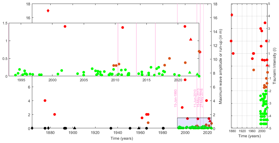
Figure 2Tsunami maximum recorded amplitude or maximum elevation run-up for each event reported in Vanuatu Arc and listed in Table S1 (left plot). Circles represent tsunamis triggered by earthquakes, triangles represent those triggered by volcanic eruptions, and diamonds represent tsunamis that could have had either earthquake or volcanic origins. The threat level code is provided by green (0–0.3 m), orange (0.3–1 m), and red (1 m and above) colours. The black colour represents the tsunamis reported in the Vanuatu Arc without any amplitude or run-up values provided. The vertical pink lines symbolize the beginning of the period of data availability for the five tide gauges located in the Vanuatu Arc. The light-blue rectangle (bottom-right of the figure) symbolizes the zoomed-in part of the panel. The right panel presents the tsunami intensity based on the Iida (1963) scale.
As most of the tsunamis recorded and/or reported in the Vanuatu Arc are triggered by earthquakes, it is interesting to show the dependency of the tsunami amplitude on the earthquake magnitude. However, this does not allow us to draw any clear trend, as shown in Fig. 3.
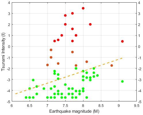
Figure 3Dependence of the tsunami intensity on the earthquake magnitude, as obtained using Iida and Imamura formulae. Linear regression is represented by the dashed orange line. The dot colour code is related to the maximum wave amplitude or vertical run-up and refers to the threat level ranges: 0–0.3 m – green symbols, 0.3–1.0 m – orange symbols, and above 1.0 m – red symbols.
Tsunamis reported or recorded in the Vanuatu Arc have multiple origins as, presented in Fig. 4: they can be triggered by earthquakes all around the Pacific Ocean Ring of Fire, especially in south-west America or Japan (Fig. 4a), or regionally by earthquakes and/or volcanoes occurring at the subduction zones in the south-west Pacific Ocean (Fig. 4b), but most of them are triggered by seismic or volcanic activity locally due to Vanuatu subduction zone processes (Fig. 4c).
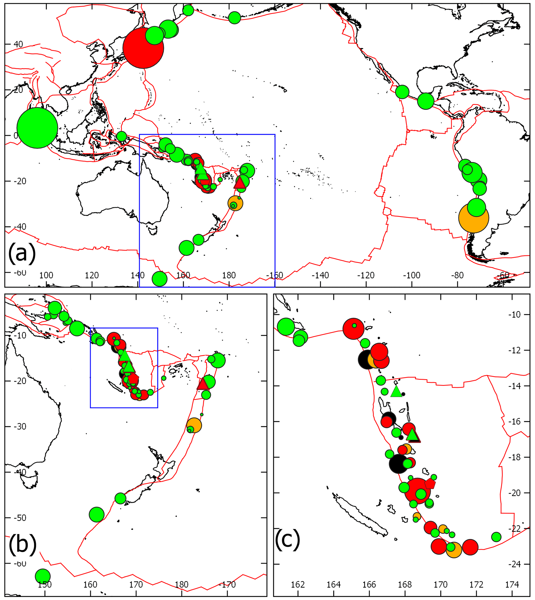
Figure 4Location of the sources of tsunami reported and/or recorded in Vanuatu Arc. (a) Oceanic scale; (b) south-west Pacific Ocean scale; (c) Vanuatu Arc scale. The red lines symbolize the plate boundaries; the blue rectangle in (a) represents the extent of (b) and in (b) the extent of (c); earthquake sources are represented with circles (size is function of the magnitude), volcanic eruptions with triangles and both earthquake and volcanic source by a pentagon; Maximum wave amplitude or vertical run-up refers to the threat level ranges: 0–0.3 m: green symbols; 0.3–1.0 m : orange symbols; above 1.0 m: red symbols; no amplitude or run-up information: black symbols.
3.2 Description of events
Note that for the oldest references, we directly rely on the information reported in (a) Soloviev and Go (1974) for the period 1863–1967 and (b) Louat and Baldassari (1989) for the period 1729–1989, the original references being Inglis (1887; in b), Robertson (1892; in b), Wawn (1893; in b), Patton (1894; in b), Davillé (1894; in a and b), Mawson (1905; in b), Bourge (1906; in a and b), O'Reilly (1956; in b), Rothé (1965; in a), and Carney and Campillo (1980; in b). In the following, the original references are also indicated. Times are indicated either local (LT) or universal (UTC) time zones.
3.2.1 Tsunamis of particular interest from local events with observation data
28–30 March 1875 (Aneityum, Aniwa, Erromango)
A huge seismic crisis felt in both the Loyalty Islands in New Caledonia and the southern Vanuatu Islands began 28 March in the southern portion of the VSZ. Major shocks occurred 28 and 30 March and were followed by a “tidal wave”, as reported by Soloviev and Go (1974) and Louat and Baldassari (1989). The first event, deadly in Lifou, Loyalty Islands, New Caledonia, was also felt severely in Aneityum, the southernmost inhabited island of Vanuatu. On Aneityum, one person drowned and others were severely hurt (Inglis, 1887, in Louat and Baldassari, 1989). The sea rose around the whole island and did serious damage to dwellings and crops (Inglis, 1887). A wave of 10–11 ft (∼ 3 m) above the spring-tide level, arriving 15 min after the earthquake, was reported (Inglis, 1887). Based on testimonies from the Loyalty Islands and numerical modelling, the magnitude of the 28 March 1875 earthquake is estimated to have been 8.1–8.2 (Ioualalen et al., 2017). The earthquake and tsunami were also felt on Erromango (Robertson, 1892) and Aniwa (Patton, 1894). On both islands a tidal wave from the second, 30 March event was higher than the 28 March one. At Erromango, Robertson (1892) indicated that he saw “a prodigious wall of sea, stretching right across the bay, and which appeared about forty feet high” (∼ 12 m). However, considering the described damage, this value is considered to be an overestimation herein.
January/February/August 1878 (Tanna volcano)
In the year 1878, several earthquakes and tsunamis associated with eruption(s) of the Mount Yasur volcano (Tanna Island) drastically changed the hydrography of Port Resolution on the south-eastern coast of Tanna Island (Patton, 1894; Mawson, 1905; Bourge, 1906; Soloviev and Go, 1974; Louat and Baldassari, 1989). On 10 January, a strong earthquake generated a 6 m uplift of the coast and a locally devastating tsunami, rising 12 m above highest tide mark (or 15–17 m high according to other sources; Soloviev and Go, 1974). On 11 February there was an even stronger shock that generated a large sea wave and caused local uplift of 12 m and the collapse of other parts of the coast into the sea. A third main shock occurred in August and again changed the morphology, raising part of the bottom of the harbour above sea level. The total uplift of the shoreline of 15 m in 1878 and the extraordinarily uplift rate (156 mm yr−1 between 1009 and 1992 CE) of the Yenkahe resurgent block, located in a partially submerged Quaternary caldera, is likely associated with the movement of magma below (Chen et al., 1995).
After 3 October 1883 (south-west Malekula)
Following an earthquake, three tidal waves swept the south-western coast of Malekula from the west. The amplitude of the tsunami was about 2 m (14 feet from trough to crest; Wawn, 1893, in Louat and Baldassari, 1989). The eyewitness, William T. Wawn, who was on board a ship anchored in the channel between Ura Islet and the south-western coast of Malekula, described the scene reported below,
At either side, on the shallow reefs, and high over the low bushes and smaller trees that lined the shore, a huge wave was breaking, sweeping steadily along the coast from westward, until it disappeared beyond a long, low point of land. It was the swell of this wave, unbroken in the deeper water, which had caught the ship aft, and had slewed her round to her anchor. On the islet we could hear the yells and cries of the natives, as they fled from an adjacent village, making for higher ground. On the main island, cloud of dust could be seen for miles away, showing where landslips has occurred on the side of the steep hills and mountains. For miles the whole surface of the earth had subsided, sinking eight feet or so, which had caused the great wave to rush into the deepened channel. Then, slowly and gradually, came an upheaval. The water poured out from the flooded forest, bearing with them portions of the huts of the savages, canoes, trees and branches, and even two or three squeaking pigs, cascading over the face of the flat shore-reefs. These now rose as high above their normal position as they had before sunk below it, forming flat terraces along the coasts, which were elevated to six feet above the surface of the sea. Masses of “Live” coral showed along the face of the raised shore-reefs, displaying brilliant hues, blue, green, yellow, purple, and red, all shining and glistening in the sun. This was the first act. A pause of a minute followed. Then, gradually and majestically, the upraised coral sank again, and the bright colour disappeared. Then came another subsidence, and a second vast billow rolled in from westward, making our chain rip and tear at the bows as if it meant to pull the windlass out of the ship. Breaking into clouds of foam, the wave ran roaring along the shores, while every here and there some huge tree came toppling over, with torn root or broken trunk. The second upheaval was not equal to the first; the reefs did not rise more than about three feet above the water. Though a third wave rolled in, it was only a “piccaninny” (small) when compared with those that had preceded it. When the earthquake was over, I could perceive no difference in the height of the shore, from the level of the sea. The only effect remaining visible were the branches and broken trees floating about, or lying strewn along the beaches, with here and there, a bare yellow brown patch on the side of the hill.
24 July 1961 (23 July UTC) Efate
During a seismic swarm located south of Efate, a Mw 7.3 earthquake was felt severely (intensity VI on the Mercalli scale) on the islands of Efate and Erromango and also (intensity IV) on Tanna, Malekula, Epi, and the Loyalty Islands. About 10 to 15 min after the shock, a tsunami with 1 to 1.5 m of vertical oscillations and a period of about 12 min, generating minor damage, was reported in Port Vila and Forari, Efate Island (Soloviev and Go, 1974; Louat and Baldassari, 1989).
12–13 August 1965 LT (11–13 August UTC) northern Malekula, southern Espiritu Santo
A seismic swarm with several strong shocks (Mw 7.2 to 7.6) occurred between Malekula and Espiritu Santo between 11 and 13 August (see Ebel, 1980). They were felt with estimated intensities of VII to VIII on the Mercalli scale at Norsup (north Malekula) and Luganville (south Espiritu Santo). Three large earthquakes on 11 and 12 August (UTC) generated significant damage, landslides, and collapses on Espiritu Santo and Malekula. The main event (Mw 7.6 at 22:31 UTC, 11 August) caused an uplift of the north-western part of Malekula of 0.5 to 0.8 m according to Benoit and Dubois (1971) and up to 1.2 m according to Taylor et al. (1980). The shock generated a tsunami that rose with a height of 7 m in some bays on Malekula (according to Rothé, 1966, in Soloviev and Go, 1974). The height of the tsunami was reported at 2.5 m on Tongoa Island and 1.2 m at Port Vila, Efate (Soloviev and Go, 1974). However, a small tsunami is indicated in other studies (Benoit, 1965, in Louat and Baldassari, 1989), and Benoit and Dubois (1971) stated that there was no tsunami associated with the main shocks. In contrast, the main aftershock on 13 August (Mw 7.4 at 12:40 UTC) was followed by a 2 m high tsunami that caused the loss of small ships on the west coast of Espiritu Santo and the destruction of coastal installations (Benoit and Dubois, 1971). The information provided by Benoit and Dubois (1971), who surveyed the islands after the event, is considered herein. A school on Malo Island was also partly flooded by a tsunami on 13 August at 14:00 UTC (Louat and Baldassari, 1989).
1 January 1967 LT (31 December 1966 UTC) Vanikoro
A large earthquake (Mw 7.8) was felt severely on Vanikoro Island in the easternmost Solomon Islands province and caused landslides and tsunamis within the lagoon, with 2 m high waves (Soloviev and Go, 1974). A tsunami was recorded at Suva (Fiji) and Pago Pago (American Samoa). A large aftershock (Mw 7.1) also generated a tsunami in the lagoon, with an amplitude of 0.8 m (Soloviev and Go, 1974).
17 May 1995 LT (16 May 1995 UTC) south Vanuatu, south-east of Walpole Island
A large normal-fault-type earthquake (Mw 7.7) located south-east of Walpole Island on the plunging plate at the southernmost part of the VSZ generated a tsunami that reached 8 m at Aneityum and 1.5 m at Erakor Island in Port Vila on Efate (Lardy, 1995). At Erakor, the water rose up to the entrance of the bungalows and stayed at a high level for 10–15 min.
21 April 1997 (Torres)
A large Mw 7.8 thrust-type earthquake occurred north of Torres Island (northern Vanuatu) and caused a local tsunami on the east of Hiu Island, with run-up elevation as high as 3 m, and generated co-seismic subsidence of at least 0.5 m on the northern part of Loh Island (Kaverina et al., 1998; Ballu et al., 2011). The tsunami heights recorded at the Port Vila, Funafuti, and Suva tide gauge stations were 20, 10, and 10 cm respectively.
26 November 1999 (east Ambrym – south Pentecost)
On 26 November 1999, a Mw 7.5 thrust-type earthquake occurred east of Ambrym Island in the back-arc compressive zone of central Vanuatu (Pelletier et al., 2000; Lagabrielle et al., 2003; Régnier et al., 2003). It is the largest known event in the Vanuatu back arc. It caused an uplift (up to 1.5 m) on the easternmost tip of Ambrym (Pelletier et al., 2000) and triggered a destructive tsunami affecting the south Pentecost and east Ambrym island shorelines, as well as on more distant islands such as Malekula and Efate, killing five people and fully destroying the village of Martelli Bay on southern Pentecost Island (Caminade et al., 2000). Run-up heights reached 6–7 m a.s.l. in Martelli Bay in the south of Pentecost (Caminade et al., 2000) and at the mouth of the Pamal River in eastern Ambrym (Pelletier et al., 2000). Tsunami modelling results are in good agreement with reported near-field run-ups (Ioualalen et al., 2006). A run-up of 1.8 m on the eastern shore of Malekuka caused the sinking of a 50 t wooden ship. Run-up heights on Efate, although far from the source, locally exceeded 1.5 m and reached 2.6 m on the northern shore (Caminade et al., 2000). The tide gauge at Port Vila recorded a maximum tsunami wave amplitude of 32 cm 30 min after the earthquake (Fig. 5).
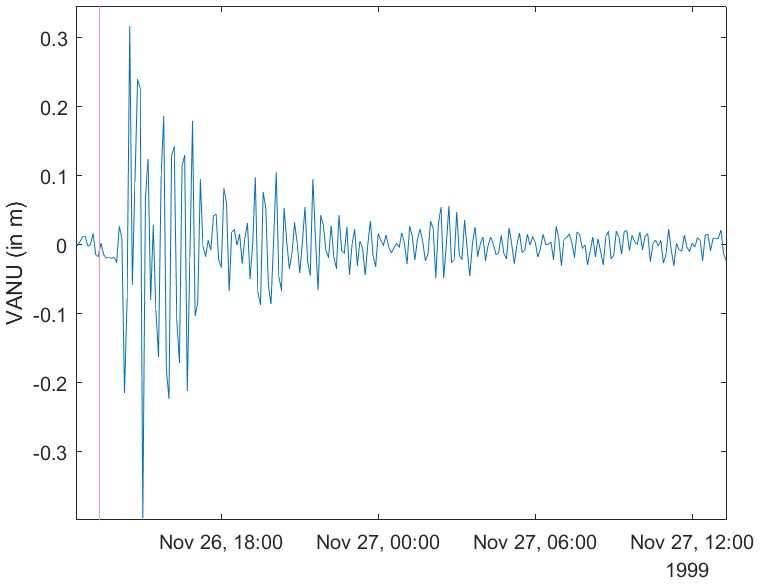
Figure 5Records from the Port Vila coastal gauge of the 26 November 1999 tsunami triggered by a Mw 7.5 earthquake east of Ambrym Island (6 min sampling rate data). The vertical red line symbolizes the earthquake time.
3 January 2002 LT (2 January 2002 UTC) Efate
A significant event of magnitude Mw 7.2, located west of Efate Island and felt on the whole island, caused some damage in the capital city of Port Vila and generated a tsunami that arrived 15 min after the shock in the bay of Port Vila. A maximum amplitude of 32 cm is recorded at the Port Vila tide gauge. However, eyewitnesses reported a much larger effect at different places around the harbour, with maximum wave heights around 3 m from trough to crest; Shorten, 2002). According to the same reference, a small tsunami following a large Mw 6.4 aftershock is also reported, although nothing can be seen on the tide gauge record.
7 October 2009 UTC (Vanikoro)
A seismic crisis with three large events showing magnitudes from Mw 7.4 to Mw 7.8 occurred south-west of Vanikoro and caused a tsunami that was recorded on the Port Vila tide gauge (30 cm). No additional information about the event was reported, and no investigation was led in the closest islands from the source (i.e. Vanikoro and the Torres Islands). Note that in Table S1 in the Supplement, only one tsunami is reported according to the gauge record analysis, but this one is associated with the two largest earthquakes (Mw 7.7 and 7.8).
6 February 2013 (Santa Cruz)
This is one of the largest (Mw 8.0) earthquakes known to have occurred along the VSZ, west of Ndende Island in the Santa Cruz Islands group, the easternmost province of the Solomon Islands (Lay et al., 2013; Romano et al., 2015). It generated a deadly tsunami that struck Ndende Island, in particular the western part of the island, with a maximum height of about 11 m and local flow depths above ground of 7 m (Fritz et al., 2013). The same authors reported that the tsunami killed 10 people, injured 15, and destroyed or damaged ∼ 1000 houses. An amplitude of ∼ 0.9 m was recorded on the tide gauge at the wharf in Lata, the main city of Ndende (Fig. 6). The tsunami was also recorded at DART stations and coastal tide gauges throughout the Pacific. The Port Vila tide gauge recorded a maximum tsunami amplitude of 33 cm (Table S1).
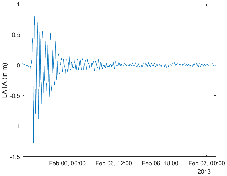
Figure 6Records from the Lata Wharf coastal gauge of the 6 February 2013 tsunami triggered by a Mw 8.0 earthquake west of Ndende Island in the Santa Cruz Islands group (1 min sampling rate data). The vertical red line symbolizes the earthquake time.
5 December 2018 (southern Vanuatu, south-east of Maré, Loyalty Islands)
On 5 December 2018, a Mw 7.5 thrust-type earthquake occurred south-east of Maré, Loyalty Islands, in the region where the Loyalty Ridge enters the trench and is subducting or colliding with the Vanuatu Arc. Widely felt in Vanuatu and New Caledonia, the shaking was quickly followed by a tsunami as detailed by Roger et al. (2019, 2021). A maximum run-up of ∼ 4 m was reported along the southern coast of Aneityum Island, the southernmost island of Vanuatu.
10 February 2021 (Matthew Island, southernmost island group of the VSZ)
On 10 February 2021, a powerful Mw 7.7 thrust-type earthquake occurred at the south-easternmost part of the VSZ, south of Matthew and Hunter islands, and generated a tsunami that was observed on most coastal gauges and DART stations in the south-west Pacific region as far as Tasmania to the south and Tuvalu to the north, at distances of 3000 and 1800 km from the epicentre, respectively (detailed in Gusman et al., 2022a; Roger et al., 2023a). The maximum amplitude of about 1.4 m was recorded on the closest tide gauge at Lenakel on Tanna Island, southern Vanuatu.
31 January 2023 (east Epi volcano eruption)
Between 25 and 31 January 2023 (UTC), an eruption occurred at one of the east Epi submarine volcanoes. The eruption evolved into a Surtseyan-style eruption on 31 January and was followed by a small tsunami showing an amplitude of ∼ 5 cm recorded on the coastal tide gauges of Port Vila to the south and Luganville to the north, located at distances of 125 and 175 km from the eruption area, respectively (Roger et al., 2023b).
19 May 2023 (south-east of Walpole Island, Loyalty Islands)
On 19 May 2023, a Mw 7.7 earthquake located south-east of Walpole Island at almost the same place but with a comparable focal mechanism solution to the 17 May 1995 event (slightly different in terms of azimuth and non-double couple component), i.e. a normal-fault-type event on the Australian plunging plate at the outer wall of the southernmost part of the VSZ, generated a small tsunami that was recorded on the tide gauges of New Caledonia, Vanuatu, and northern New Zealand. The largest wave was recorded at the Lenakel tide gauge on Tanna, showing a maximum amplitude of 70 cm. Note that this tide gauge stopped transmitting data afterwards.
3.2.2 Tsunamis from far-field and regional origins with observation data
Since the installation of the 6 min sampling rate tide gauge in Port Vila in 1993 and then at the three other locations in Vanuatu, tsunamis from far-field and regional origins have been recorded.
- a.
Far-field origin.
The 4 October 1994 Mw 8.3 Shikotan (Kuril Islands)–Hokkaido (Japan), the 10 June 1996 Mw 7.9 (Alaska), the 23 June 2001 Mw 8.4 southern Peru, the 26 December 2004 Mw 9.1 (Sumatra), the 15 November 2006 Mw 8.3 (Kuril Islands), the 27 February 2010 Mw 8.8 Maule (Chile), the 11 March 2011 Mw 9.1 Tōhoku (Japan), the 1 April 2014 Mw 8.2 Iquique (Chile), the 16 September 2015 Mw 8.3 Illapel (Chile), and the 8 September 2017 Mw 8.2 Chiapas (Mexico) tsunamis were recorded.
All these recent widespread transpacific tsunamis, recorded on most of the gauges of the Pacific Ocean, were registered on the gauges in the Vanuatu Arc. For instance, on the Port Vila tide gauge, the Maule tsunami perturbed the sea-level in the harbour where the gauge is located for more than 2 d following the first arrival of the tsunami on 27 February 2010, showing a maximum amplitude of ∼ 0.3 m (Fig. 7). The Tōhoku tsunami arrived at Port Vila ∼ 8 h after the main earthquake on 11 March 2011, showing a maximum height of ∼ 0.7 m (Fig. 7) and perturbing the harbour for more than 3 d. This was also the case for the 2004 global transoceanic “Indian Ocean” tsunami, which reached the Port Vila tide gauge after ∼ 21 h of propagation, showing a maximum height of ∼ 0.1 m (Fig. 7) and perturbing the harbour for more than 4 d.
- b.
Regional origin.
The 16 November 2000 Mw 8.0 Rabaul (Papua New Guinea), the 1 April 2007 Mw 8.1 Gizo (New Georgia Islands group, Solomon Islands), the 23 December 2004 Mw 8.1 Macquarie Island (Australia), the 29 September 2009 Mw 8.1 Samoa–north Tonga, the 5 March 2021 Mw 8.1 Kermadec, and the 15 January 2022 Hunga Tonga–Hunga Ha'apai eruption (Tonga) were also recorded.
The recent major tsunamis of regional origin have been also recorded on the Vanuatu Arc tide gauges (see the list above) except for the deadly 17 July 1998 Aitape (Papua New Guinea) tsunami, which is supposed to have been mainly caused by a submarine slump triggered by the shaking of the initial Mw 7.0 earthquake (Synolakis et al., 2002).
On 5 March 2021, three earthquakes of magnitude Mw 7.3, 7.4, and 8.1 occurred on the Hikurangi–Kermadec subduction zone and triggered three distinct tsunamis recorded on coastal gauges and DART stations of the south-west Pacific. The third one had a wider impact, being recorded in many places across the Pacific Ocean and some locations in the Atlantic and Indian oceans (Roger, 2023). It was clearly recorded in Vanuatu at the LENA, VANU, and LITZ coastal gauges, with a maximum amplitude of 38 cm at LENA.
The widespread tsunami triggered by the 15 January 2022 eruption of the Hunga Tonga–Hunga Ha'apai volcano was recorded well in the south-west Pacific region (e.g. Gusman et al., 2022b) and particularly on the Vanuatu tide gauges VANU, LITZ, and LUGA, where it reached amplitudes of 0.5 m or more, as shown in Fig. 8.

Figure 7Records from the Port Vila coastal gauge of three transoceanic tsunamis during the 6 d after each related earthquake: (a) the 11 March 2011 tsunami triggered by the Mw 9.1 Tōhoku earthquake in Japan, (b) the 27 February 2010 tsunami triggered by the Mw 8.8 Maule earthquake in Chile, and (c) the 26 December 2004 tsunami triggered by the Mw 9.1 Sumatra earthquake in Indonesia; the vertical red line symbolizes the earthquake time. The data were detided using a bandpass filter. (a, b – 1 min sampling rate data; c – 6 min sampling rate data).
3.2.3 Tsunamis reported without details (black events in Table 1 and Fig. 1)
17 August 1863 (LT) Erromango, Tanna
The oldest known tsunami reported in Vanuatu occurred on 17 August 1863 (Soloviev and Go, 1974). Following a shock felt in New Caledonia, most strongly at Kanala and Vagap (Poindimié) on the east coast of Grande Terre, the schooner Ariel, passing Port de France (former name for Nouméa before 1966) on 26 August 1863, reported that a shock on 17 August was also felt on Erromango Island and was accompanied by a large wave that must have done great damage on land. Another schooner that was close to Tanna Island reported that the shock may have been related to an eruption of Yasur volcano on Tanna Island.
August 1892, first week, about 00:20 (LT) Espiritu Santo
A very strong shock was felt at Luganville, Espiritu Santo Island. An eyewitness, Davillé, who was sleeping on the top deck of a small schooner at Shark Bay on the east coast of Espiritu Santo, woke up and saw that a gigantic foaming roller had suddenly appeared on the hitherto calm sea surface and was advancing toward the schooner from south to north (Davillé, 1894, in Soloviev and Go, 1974; and in Louat and Baldassari, 1989).
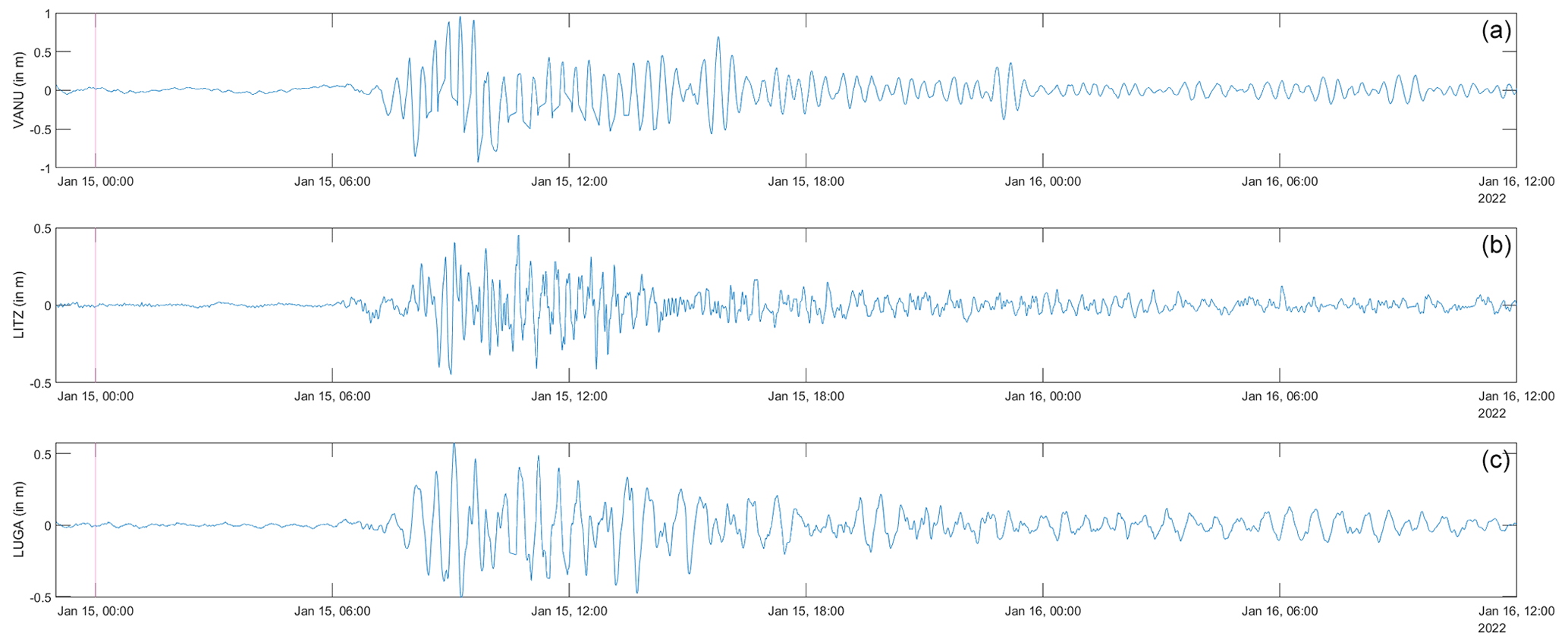
Figure 8Records of the HTHH tsunami from three of the five coastal gauges of the Vanuatu Arc. From south (a) to north (c): VANU, LITZ, and LUGA. The vertical red line indicates the time of the main volcanic eruption.
27 August 1893 (LT) Efate
A wave crossed the bay of Port Vila and reached the coffee shop of the French merchant company (Davillé, 1894, in Soloviev and Go, 1974, and in Louat and Baldassari, 1989).
8 August 1901 (LT) Karua, south-east Epi
A tsunami followed an eruption of a volcano near Epi Island on 8 August 1901, as described by testimonies reported in the Sydney Morning Herald (1901), “The eruption was followed by a tidal wave, which did infinitely greater damage to the plantations than the eruption.” The responsible volcano is likely to have been Karua, located south-east of Epi Island, which is known to have been very active in 1900–1901 (Eissen et al., 1991).
19–20 November 1933 (LT) Malekula
Earthquakes were felt on Malekula Island. One of them, on 19 November, was strong enough to damage the church and other buildings at Lamap, southern Malekula. Following these shocks, the southern coast of Makekula, at least the region from Assouk to Port Ravallec, subsided about 0.3–0.4 m. It is also reported that the subsidence was accompanied by a small tsunami (Louat and Baldassari, 1989).
3–4 December 1950 (LT) south-west Efate
Following a seismic crisis felt in Port Vila (22 shocks in 24 h) including a large Mw 7.9 earthquake on 2 December 1950 at 19:52 UTC, located south-west of Efate and west-north-west of Erromango, a tsunami was reported from Erakor Island, Port Vila (O'Reilly, 1956, in Louat and Baldassari, 1989).
7 October 1958 (LT) east Epi
Unusual waves reported by locals on the south-east of Epi Island seemed to be caused by an underwater volcanic eruption (Soloviev and Go, 1974). An aeroplane survey of the region by the French naval aviation on 7 October 1958 around 10:00 LT revealed spots and streams of discoloured water from the so-called “Epi B” underwater volcano, as well as bubbling of water above the submarine Karua volcano located on the Kuwae caldera (sketch of de Brossard, 1958, in Eissen et al., 1991). Further aircraft surveys on 18 November (Lt. Valette) and 16 December (Roland Priam) reported the same manifestations but with less intensity (Eissen et al., 1991).
13 May 1980 LT (12 May 1980 16:37 UTC) Mere Lava
A Mw 6.1 earthquake, located east of Mere Lava Island (Banks Islands group) and felt with an intensity of V–VI on the island, caused a small tsunami corroborated by the stranding of fish on the shore near Tasmat village, as reported by Father Langon in Carney and Campillo (1980) in Louat and Baldassari (1989).
9 and 18 July 1980 (LT) Torres
Following large-thrust fault-type earthquakes (Mw 7.5 on 8 July at 23:19 UTC and Mw 7.9 on 17 July at 19:42 UTC) occurring north of the Torres Islands, run-up heights of less than 2 m were reported in Lockridge and Smith (1984) without more details, including the precise locations. Small tsunami waves were reported at the tide gauge of Port Vila (Carney and Campillo 1980, in Louat and Baldassari 1989). As previously indicated, the tide gauge data from Port Vila for this period seem to no longer be available.
3.3 Potential tsunamis from debated local events
3.3.1 1452 CE Kuwae eruption (tsunami from volcanic eruption)
The Vanuatu Arc, showing several aerial and submarine explosive-type active volcanoes with steep slopes, can be seen as a strong candidate to produce volcanism-triggered tsunamis. A destructive tsunami was reported associated with the eruption of Yasur volcano on Tanna Island in 1878, and tsunamis related to the eruption of the east Epi volcano were reported in October 1958 and recorded in January 2023 (Roger et al., 2023b).
The large (12 km × 6 km) Kuwae submarine caldera located between Tongoa and Epi islands is considered to be the result of a gigantic eruption in the mid-15th century (Monzier et al., 1994; Witter and Self, 2007). This cataclysm, which broke the former Kuwae volcano and separated all the neighbouring islands into their present distribution, is widely reported in the Vanuatu oral tradition and in several kastom stories and may have caused a large destructive tsunami. However, with the exception of the preliminary work of Goff et al. (2008), the potential sedimentary deposits of this major event have not been researched so far.
3.3.2 Tsunamis from landslides?
Several reported particular waves or abnormal movements of the sea not associated with any earthquakes may have been triggered by local landslides. Indeed, such events caused by underwater or subaerial landslides may likely have occurred along the VSZ. This could be the case for the event on 13 March 1959 that destroyed the Catholic mission at Loanatom, Tanna Island (Wallez, 1998), the tsunami on 28 November 1966 at 13:00 LT in Mohawk Bay, Santa Cruz Islands (Soloviev and Go, 1974), and the event on 10 July 1993 at Whitesands, southern coast of Efate Island (testimony collected by the Office of Scientific and Technical Research Overseas (ORSTOM) (France) and reported in Wallez, 1998).
3.4 Tsunamis not reported in Vanuatu but elsewhere around – not in the catalogue
3.4.1 Local and regional tsunamis
Some tsunamis triggered by local earthquakes along the VSZ and regional events from the Solomon subduction zone (Mw 8.1 shock on 21 September 1920 LT west of Aneityum Island, Mw 7.8 on 4 October 1931 LT south-west of San Cristobal Island, Mw 7.7 on 19 July 1934 LT west-south-west of Vanikoro Island, Mw 7.3 on 21 July 1934 south-west of Ndende Island) and reported in other neighbouring locations, for example in New Caledonia (Soloviev and Go, 1974; Sahal et al., 2010), have not been reported in the Vanuatu Arc islands. This raises the question in particular for the largest event ever recorded in Vanuatu since 1900, i.e. the Mw 8.1 earthquake on 20 September 1920 UTC that went unnoticed in Vanuatu and almost unnoticed in New Caledonia (Louat and Baldassari, 1989) and for which a tsunami was reported 4 h and 30 min later on Apia, Samoa (Soloviev and Go, 1974). Estimated local run-up of 2 to 6 m is indicated in Lockridge and Smith (1984). However, no run-up has been reported anywhere. Based on the lack of testimony (except one in Ouvéa Island, New Caledonia, reported by Sahal et al., 2010) and numerical modelling, the magnitude of this event is estimated to be 7.5–7.8 instead of 8.1 (Ioualalen et al., 2017).
3.4.2 Transoceanic tsunamis
Similar to local and regional events, the widespread transpacific tsunamis generated by the 4 November 1952 Mw 9.0 Kamchatka earthquake or by the 22 May 1960 Mw 9.5 Chile earthquake have not been reported in Vanuatu, although they were documented in New Caledonia (i.e. the Chile event in Sahal et al., 2010) and in other countries in the south-west Pacific region, i.e. Fiji, New Zealand, and Australia.
4.1 About the catalogue and the knowledge of the tsunami hazard
This list of tsunamis shows that Vanuatu and the eastern Solomon Islands are exposed to this natural hazard. A total of 100 tsunamis have been identified since 1863 and 78 since 1993 when the sampling rate of the tide gauges was set up high enough to record small ones. Tsunami sources are local, regional, and distant (far-field tsunamis). Tsunamis of local origin show the largest amplitudes and/or run-ups, except the 2011 Tōhoku tsunami, which is one of the largest tsunamis recorded and/or reported in the Vanuatu Arc. Only seven of them show run-up values higher than 3 m and three have been deadly. At least 1 man drowned on Aneityum following the large 1875 earthquake, there were 5 victims on south Pentecost following the 1999 Mw 7.5 east Ambrym earthquake, and 10 fatalities occurred on west Ndende following the 2013 Mw 8.0 Ndende earthquake. The low number of casualties is likely due to the fact that tsunamis were not very large or highly powerful (maximum earthquake magnitude M ∼ 8) but also chiefly results from very good knowledge of the tsunami phenomenon, which is orally transmitted between generations through myths (e.g. Nunn et al., 2006). The good understanding of the tsunami hazard appears quite well in the writings recounting historical events (like that of 1875) and was clearly pointed to by the international tsunami survey teams following the deadly events of 1999 (Caminade et al., 2000) and 2013 (Fritz et al., 2013). However, it is important to note that it is always difficult to collect precise testimonies, especially over large regions like the Vanuatu Arc and even for recent events as indicated by Rahmi et al. (2019).
It is important to indicate that there is a lack of knowledge about underwater landslides in Vanuatu, which are known to be able to trigger very localized and potentially large-amplitude tsunamis (Roger et al., 2024).
Also, underwater volcanoes are not well-known, and there is a high potential for the existence of active volcanoes especially within a 400 km long section without aerial active volcanoes in the northern part of the arc between Vanua Lava (Banks Islands, Vanuatu) and Tinakula (eastern Solomon Islands).
This study allows us to build a tsunami exceedance frequency curve (Fig. 9), showing the cumulative rate of tsunamis (per year) exceeding the amplitude or run-up value given by the present tsunami catalogue over the period 1863–2023. A common practice is to fit a simple power law (e.g. , shown in Fig. 9), which provides a good approximation, except for the largest amplitudes (low exceedance frequency). Using the work from Burroughs and Tebbens (2001) on the fitting of an upper-truncated power law to a cumulative dataset and proposing the equation of the upper-truncated power law M as , where r is the object size (the maximum amplitude or run-up in our case), RT is the maximum size, and C and D are constant values providing the best fit of the upper-truncated power law, we found a best fit with C= 0.0993 and D= −0.4626. Visual comparison with the results obtained by Geist and Parsons (2006) for Acapulco tsunamis shows strong similarity with the trend they obtained but with a higher exceedance frequency generally, keeping also in mind that the Vanuatu catalogue probably does not show all the historical events over the period considered (especially during the non-instrumental period) and that the number and types of observations are also not representative of all the locations in Vanuatu, which may result in bias and underestimation of the tsunami hazard.
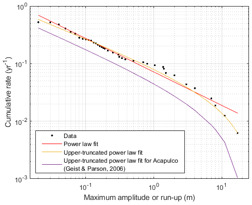
Figure 9Tsunami exceedance frequency curve showing the cumulative rate of tsunamis (yr−1) exceeding the maximum amplitude or run-up value given by the x axis for the present tsunami catalogue of the Vanuatu Arc over the period 1863–2023. The black dots represents the data, the red line represents the trend with a power law fit (a= 0.0716; b= −0.581), the yellow line represents the trend using an upper-truncated power law fit based on the work from Burroughs and Tebbens (2001) with C= 0.0993 and D= −0.4626, and the purple line is an example of the trend using an upper-truncated power law fit for tsunami exceedance frequency for Acapulco (Geist and Parsons, 2006).
4.2 Improvement of tsunami hazard knowledge
This study clearly demonstrates that there is a lack of both geographic and temporal coverage of records and observations all along the Vanuatu Arc. Only five recently installed coastal gauges are disseminated along the approximately 1500 km long Vanuatu Arc. Moreover, these gauges were installed for oceanographic purposes (i.e. tide observation and sea-level rise) and are not specifically designed for tsunami recording. In addition, they are not regularly spaced along the arc, they are located in semi-enclosed places (like harbours, or bays), potentially subject to disturbances triggered by navigation and resonance phenomenon, and sometimes they do not transmit real-time data.
In 2021, two DART stations were established by New Zealand as part of the New Zealand DART Network (Power et al., 2018) in front of the southern part of the Vanuatu Arc, in addition to the Australian one located north-north-west of New Caledonia between the northern part of the Vanuatu Arc and Australia.
Deployment of additional coastal gauges and/or sea-bottom pressure sensors (like DART stations for example) is strongly recommended to collect more tsunami records in order to improve the hazard knowledge in that region. We note that a SMART (Science Monitoring And Reliable Telecommunications) cable project is under development between Vanuatu and New Caledonia (Howe et al., 2022). This SMART cable technology provides an additional opportunity to monitor sea-level variations caused by tsunami wave propagation through the integration of pressure sensors among other environmental instruments in the system (Howe et al., 2019). Once installed, it will be able to help assess whether a tsunami was triggered by an earthquake or not, complementing the DART systems already operational in the region. It may also allow us to detect underwater landslides, which are potential tsunami sources. In fact, tsunami sources other than earthquakes, like submarine landslides and volcanic eruptions, are not well known in the Vanuatu Arc. One of the reasons is the lack of high-resolution bathymetric data around the numerous islands' slopes and the poor knowledge of the underwater volcanic activity in the region.
Finally, the very limited period of time covered by the present catalogue could be increased via the analysis and precise dating of sediments moved by tsunami waves: paleo-tsunami surveys led in environments able to preserve marine submersion footprints for centuries or more (e.g. swamps, lagoons, topographic depressions, etc.).
Most of the coastal gauge records used in the present study are publicly available online (https://doi.org/10.14284/482, VLIZ/IOC, 2024). The other datasets were provided by the Bureau of Meteorology (Australia).
Table S1 – catalogue of the tsunamis reported and/or recorded in the Vanuatu Arc since 1863. The colour of the lines depends on the maximum wave amplitude or vertical run-up value, referring to the threat level ranges: 0–0.3 m – green, 0.3–1.0 m – orange, above 1.0 m – red, and no amplitude or run-up information – black. No values are indicated by “NaN”. The supplement related to this article is available online at: https://doi.org/10.5194/nhess-24-3461-2024-supplement.
JR organized the study, collected and processed the coastal gauge data, analysed the results, prepared the figures, and wrote the paper. BP collected and summarized historical documents and wrote the paper. The two authors agreed on the submitted version of the paper.
The contact author has declared that neither of the authors has any competing interests.
Publisher’s note: Copernicus Publications remains neutral with regard to jurisdictional claims made in the text, published maps, institutional affiliations, or any other geographical representation in this paper. While Copernicus Publications makes every effort to include appropriate place names, the final responsibility lies with the authors.
The authors are grateful to Mike Davis (Bureau of Meteorology, Australia), who shared the data for the LATA and VANU gauges, as well as to Efim Pelinovsky and an anonymous referee for their constructive comments that helped improve the quality of the paper.
This work was supported by GNS Science's Hazards and Risk Management (HRM) science programme funded through the Strategic Science Investment Fund (SSIF).
This paper was edited by Ira Didenkulova and reviewed by Efim Pelinovsky and one anonymous referee.
Aldrich, R.: From the New Hebrides to Vanuatu, in: France and the South Pacific since 1940, Palgrave Macmillan, London, https://doi.org/10.1007/978-1-349-10828-2_6, 1993.
Ballu, V., Bouin, M-N., Siméoni, P., Crawford C., Calmant S., Kanas T., Boré J.-M., and Pelletier B.: Comparing the role of absolute sea-level rise and vertical tectonic motions in coastal flooding, Torres Islands (Vanuatu), P. Natl. Acad. Sci. USA, 108, 13019–13022, 2011.
Bedford, S., Hoffman, A., Kaltal, M., Regenvanu, R., and Shing, R.: Dentate-stamped Lapita reappears on Efate, Central Vanuatu: a four decade-long drought is broken, Archaeology in New Zealand, 47, 39–49, 2004.
Bedford, S., Spriggs, M., and Regenvanu, R.: The Teouma Lapita site and the early human settlement of the Pacific Islands, Antiquity, 80, 812–828, https://doi.org/10.1017/S0003598X00094448, 2006.
Bedford, S., Spriggs, M., Regenvanu, R., Macgregor, C., Kuautonga, T., and Sietz, M.: The excavation, conservation and reconstruction of Lapita burial pots from the Teouma site, Efate, Central Vanuatu, in: Oceanic Explorations: Lapita and Western Pacific Settlement, edited by: Bedford, S., Sand, C., and Connaughton, S., Canberra, Australian National University E Press, Terra Australis, 25, 223–240, 2007.
Benoit, M. and Dubois, J.: The earthquake swarm in the New Hebrides archipelago, August 1965, Recent Crustal Movements, Roy. Soc. NZ Bull., 9, 141–148, 1971.
Bourge, G.: Les Nouvelles-Hebrides de 1606 à 1906, edited by: Challamel, A., Librairie Maritime et Coloniale, Paris, 1906.
Burroughs, S. M. and Tebbens, S. F.: Upper-truncated power law distributions, Fractals, 9, 209–222, 2001.
Calmant, S., Pelletier, B., Bevis, M., Taylor, F., Lebellegard, P., and Phillips, D.: New insights on the tectonics of the New Hebrides subduction zone based on GPS results, J. Geophys. Res., 108, 2319–2340, https://doi.org/10.1029/2001JB000644, 2003.
Caminade, J. P., Charlie, D., Kanoglu, U., Koshimura, S., Matsutomi, H., Moore, A., Ruscher, C., Synolakis, C. E., and Takahashi, T.: Vanuatu earthquake and tsunami cause much damage, few casualties, EOS Trans. AGU, 81, 646–647, https://doi.org/10.1029/EO081i052p00641-02, 2000.
Carney, J. N. and Campillo, R.: An investigation into damage caused by seismic activity on Mere Lava, banks Group, During May 1980, Port-VHa Aug, Vanuatu Geological Survey Department, p. 11, 1980.
Carney, J. N. and Macfarlane, A.: Geological evidence bearing on the Miocene to Recent structural evolution of the New Hebrides arc, Tectonophysics, 87, 147–175, https://doi.org/10.1016/0040-1951(82)90225-6, 1982.
Chen, J. K., Taylor, F. W., Edwards, L., Cheng, H., and Burr, G. S.: Recent emerged reef terraces of the Yenkahe resurgent block: implications for volcanic, landslide and tsunami hazards, J. Geol., 103, 577–590, 1995.
Costa, P. J., Gelfenbaum, G., Dawson, S., La Selle, S., Milne, F., Cascalho, J., Ponte Lira, C., Andrade, C., Freitas, M. C., and Jaffe, B.: The application of microtextural and heavy mineral analysis to discriminate between storm and tsunami deposits, Geol. Soc. Spec. Publ., 456, 167–190, https://doi.org/10.1144/SP456.7, 2018.
Davillé, E.: Tremblements de terre aux Nouvelles-Hebrides, Societe de Geographie Paris, Compte rendu de la Seance du 18 Mai 1894, 245–251, 1894.
de Brossard: Lettre sur l'observation d'un phénomène sous-marin aux Hébrides, 1 page + un schéma, 1958.
Ebel, J. E.: Source processes of the 1965 New Hebrides Islands earthquakes inferred from teleseismic wave forms, Geophys. J. Roy. Astr. S., 63, 381–403, 1980.
Eissen, J. P., Blot, C., and Louat, R.: Chronologie de l'activité volcanique historique de l'arc insulaire des Nouvelles-Hébrides de 1595 à 1991, ORSTOM, Nouméa, Nouvelle-Calédonie, Sciences de la Terre, Géologie Géophysique, Rapport Scientifique et Technique, no. 2, 68 pp., 1991.
Friedlaender, J. S., Gentz, F., Green, K., and Merriwether, D. A.: A cautionary tale on ancient migration detection: mitochondrial DNA variation in Santa Cruz Islands, Solomon Islands, Hum. Biol., 74, 453–471, 2002.
Fritz, H. M., Papantoniou, A., Biukoto, L., and Albert, G.: The Solomon Islands Tsunami of 6 February 2013 field survey in Santa Cruz Islands, American Geophysical Union, Fall Meeting 2013, 9–13 December 2013, San Francisco, California, NH41A-1696, https://ui.adsabs.harvard.edu/abs/2013AGUFMNH41A1696F/abstract (last access: 8 October 2024), 2013.
Geist, E. L. and Parsons, T.: Probabilistic Analysis of Tsunami Hazards, Nat. Hazards, 37, 277–314, https://doi.org/10.1007/s11069-005-4646-z, 2006.
Goff, J., Douglas, C., Haruel, C., and Bonte-Grapentin, M.: Preliminary findings of the geology evidences and oral history of tsunamis in Vanuatu, SOPAC Report, 416, 49 pp., 2008.
Green, R. C.: A reappraisal of the dating for some Lapita sites in the Reef/Santa Cruz Group of the Southeast Solomons, J. Polynesian Soc., 100, 197–207, 1991.
Gusiakov, V. K.: Tsunami history: recorded. The sea, 15, 23–53, http://tsun.sscc.ru/hiwg/PABL/Gusiakov_2008.pdf (last access: 8 October 2024), 2009.
Gusman, A. R., Roger, J., Power, W., Fry, B., and Kaneko, Y.: The 2021 Loyalty Island earthquake (Mw 7.7): tsunami waveform inversion and implications for tsunami forecasting for New Zealand, Earth Space Sci., 9, e2022EA002346, https://doi.org/10.1029/2022EA002346, 2022a.
Gusman, A. R., Roger, J., Noble, C., Wang, X., Power, W., and Burbidge, D.: The 2022 Hunga Tonga-Hunga Ha'apai Volcano Air-Wave Generated Tsunami, Pure Appl. Geophys., 179, 3511–3525, https://doi.org/10.1007/s00024-022-03154-1, 2022b.
Hilliard, D.: Colonialism and Christianity: The Melanesian mission in the Solomon Islands, J. Pac. Hist., 9, 93–116, https://doi.org/10.1080/00223347408572247, 1974.
Howe, B. M., Angove, M., Aucan, J., Barnes, C. R., Barros, J. S., Bayliff, N., Becker, N. C., Carrilho, F., Fouch, M. J., Fry, B., and Jamelot, A.: SMART subsea cables for observing the earth and ocean, mitigating environmental hazards, and supporting the blue economy, Front. Earth Sci., 9, 775544, https://doi.org/10.3389/feart.2021.775544, 2022.
Howe, B. M., Arbic, B. K., Aucan, J., Barnes, C. R., Bayliff, N., Becker, N., Butler, R., Doyle, L., Elipot, S., Johnson, G. C., and Landerer, F.: SMART cables for observing the global ocean: science and implementation, Front. Mar. Sci., 6, 424, https://doi.org/10.3389/fmars.2019.00424, 2019.
Iida, K.: Magnitude, energy and generation mechanisms of tsunamis and a catalogue ofearthquakes associated with tsunamis, Proc. Tsunami Meeting, 10th Pacific Sci. Congress, Honolulu, Hawaii, 1961, IUGG Monograph, 24, 7–18, 1963.
Inglis, R. J.: In the New Hebrides, Reminiscences of missionary life and work, T. Nelson and Sons, London, 1887.
Ioualalen, M., Pelletier, B., Watts, P., and Regnier, M.: Numerical modeling of the 26 November 1999 Vanuatu tsunami, J. Geophys. Res.-Oceans, 111, C06030, https://doi.org/10.1029/2005JC003249, 2006.
Ioualalen, M., Pelletier, B., and Solis Gordillo, G.: Investigating the March 28th 1875 and the September 20th 1920 earthquakes/tsunamis of the Southern Vanuatu arc, offshore Loyalty Islands, New Caledonia, Tectonophysics, 709, 20–38, https://doi.org/10.1016/j.tecto.2017.05.006, 2017.
Kaverina, A., Dreger, D., and Antolik, M.: Source process of the 21 April, 1997 Santa Cruz Island earthquake (Mw 7.8), Geophys Res. Lett., 25, 4027–4030, https://doi.org/10.1029/1998GL900017, 1998.
Kirch, P. V. and Swift, J. A.: New AMS radiocarbon dates and a re-evaluation of the cultural sequence of Tikopia Island, Southeast Solomon Islands, J. Polynesian Soc., 126, 313–336, 2017.
Lagabrielle, Y., Pelletier, B., Cabioch, G., Regnier, M., and Calmant, S.: Coseismic and long-term vertical displacement due to back arc shortening, central Vanuatu: Offshore and onshore data following the Mw 7.5, 26 November 1999 Ambrym earthquake, J. Geophys. Res., 108, 2519, https://doi.org/10.1029/2002JB002083, 2003.
Lardy M.: Quelques remarques à propos du séisme et tsunami du 17 mai 1995 à Port Vila, Note ORSTOM Port-Vila du 29 mai 1995, 1995.
Lay, T., Ye, L., Kanamori, H., Yamazaki, Y., Cheung, K. F., and Ammon, C. J.: The February 6, 2013 Mw 8.0 Santa Cruz Islands earthquake and tsunami, Tectonophysics, 608, 1109–1121, https://doi.org/10.1016/j.tecto.2013.07.001, 2013.
Lockridge, P. A. and Smith, R. H.: Tsunamis in the Pacific basin, 1900–1983, Map, National Geophysical Data Center, Boulder, Colorado, https://nla.gov.au/nla.obj-234313658/view (last access: 8 October 2024), 1984.
Louat, R. and Baldassari, C.: Chronologie des séismes et des tsunamis ressentis dans la région Vanuatu Nouvelle-Calédonie (1729–1989), ORSTOM, Nouméa, Nouvelle-Calédonie, Sciences de la Terre, Géologie Géophysique, Rapport Scientifique et Technique, no. 1, 46 pp., https://horizon.documentation.ird.fr/exl-doc/pleins_textes/divers08-01/27091.pdf (last access: 8 October 2024), 1989.
Mawson, D.: The geology of the New Hebrides, in: Vol. 30, part Ill, Proceedings of the Linnean Society of New South Wales, 400–485, 1905.
Monzier, M., Robin, C., and Eissen, J.-P.: Kuwae (∼ 1425 A.D.): the forgotten caldera, J. Volcanol. Geoth. Res., 59, 207–218, 1994.
National Geophysical Data Center/World Data Service: NCEI/WDS Global Historical Tsunami Database, NOAA National Centers for Environmental Information, https://doi.org/10.7289/V5PN93H7, last access: 6 September 2023.
Nunn, P. D., Heorake, T., Tegu, E. T., Oloni, B., Simeon, K. A., Wini, L., Usuramo, S., and Geraghty, P.: Geohazards revealed by myths in the Pacific: a study of islands that have disappeared in Solomon Islands, South Pacific Studies, 27, 37–49, https://core.ac.uk/download/pdf/144568478.pdf (last access: 8 October 2024), 2006.
O'Reilly, P.: Chronologie des Nouvelles-Hebrides, Journal de la Societe des Oceanistes, 12, 6–61, 1956.
Patton, M. W.: Letters and Sketches from The New Hebrides, Rev. JAS PATON Editor, Hodder and Stroughton, London, 1894.
Pelletier, B., Calmant, S., and Pillet, R.: Current tectonics of the Tonga-New Hebrides region, Earth Planet. Sc. Lett., 164, 263–276, 1998.
Pelletier, B., Regnier, M., Calmant, S., Pillet, R., Cabioch, G., Lagabrielle, Y., Bore, J.-M., Caminade, J.-P., Cristopher, I., and Temakon, S.: Le séisme d'Ambrym-Pentecôte (Vanuatu) du 26 novembre 1999: données préliminaires sur la séismicité, le tsunami et les déplacements associés, CR Acad. Sci. A, 331, 21–28, https://doi.org/10.1016/S1251-8050(00)01382-3, 2000.
Petchey, F., Spriggs, M., Bedford, S., Valentin, F., and Buckley, H.: Radiocarbon dating of burials from the Teouma Lapita cemetery, Efate, Vanuatu, J. Archaeol. Sci., 50, 227–242, https://doi.org/10.1016/j.jas.2014.07.002, 2014.
Power, W. L., Fry, B., Gusman, A. R., Burbidge, D. R., Brewer, M., and Wang, X.: DART buoys network design. GNS Science consultancy report 2018/147, 53 pp., https://www.gns.cri.nz/research-projects/dart-deep-ocean-assessment-and-reporting-of-tsunami/ (last access: 8 October 2024), 2018.
Rahmi, R., Joho, H., and Shirai, T.: An analysis of natural disaster-related information-seeking behavior using temporal stages, J. Assoc. Inf. Sci. Tech., 70, 715–728, https://doi.org/10.1002/asi.24155, 2019.
Regnier, M., Calmant, S., Pelletier, B., Lagabrielle, Y., and Cabioch, G.: The Mw 7.5 1999 Ambrym earthquake, Vanuatu: A back arc intraplate thrust event, Tectonics, 22, 1034–1047, https://doi.org/10.1029/2002TC001422, 2003.
Robertson, M. A.: Erromanga the Martyr Isle, Hodder and Stoughton, London, 1892.
Roger, J.: Records of the 5 March 2021 Raoul Island transoceanic tsunami around the Pacific Ocean, New Zeal. J. Geol. Geop., https://doi.org/10.1080/00288306.2023.2225859, in press, 2023.
Roger, J., Pelletier, B., and Aucan, J.: Update of the tsunami catalogue of New Caledonia using a decision table based on seismic data and marigraphic records, Nat. Hazards Earth Syst. Sci., 19, 1471–1483, https://doi.org/10.5194/nhess-19-1471-2019, 2019.
Roger, J., Pelletier, B., Duphil, M., Lefèvre, J., Aucan, J., Lebellegard, P., Thomas, B., Bachelier, C., and Varillon, D.: The Mw 7.5 Tadine (Maré, Loyalty Islands) earthquake and related tsunami of 5 December 2018: seismotectonic context and numerical modeling, Nat. Hazards Earth Syst. Sci., 21, 3489–3508, https://doi.org/10.5194/nhess-21-3489-2021, 2021.
Roger, J., Pelletier, B., Gusman, A., Power, W., Wang, X., Burbidge, D., and Duphil, M.: Potential tsunami hazard of the southern Vanuatu subduction zone: tectonics, case study of the Matthew Island tsunami of 10 February 2021 and implication in regional hazard assessment, Nat. Hazards Earth Syst. Sci., 23, 393–414, https://doi.org/10.5194/nhess-23-393-2023, 2023a.
Roger J., Ashraf, S., Pelletier, B., Krippner, J., Bani, P., Gusman, A.R., Thomas, B., and Kali, J.-C.: The East-Epi Volcano submarine eruption and associated tsunami of 31 January 2023: a powerful event in the shadow of the HTHH eruption, American Geophysical Union, Fall Meeting 2023, https://ui.adsabs.harvard.edu/abs/2023AGUFMNH51D0505R/abstract (last access: 8 October 2024), 2023b.
Roger, J., Bull, S., Watson, S., Mueller, C., Hillman, J., Wolter, A., Lamarche, G., Power, W., Lane, E., Woelz, S., and Davidson, S.: A review of approaches for submarine landslide tsunami hazard identification and assessment, in: Special issue on Submarine Geohazards in/along the western Pacific Ocean, edited by: Switzer, A., Mar. Petrol. Geol., 162, 106729, https://doi.org/10.1016/j.marpetgeo.2024.106729, 2024.
Romano, F., Molinari, I., Lorito, S., and Piatanesi, A.: Source of the 6 February 2013 Mw = 8.0 Santa Cruz Islands Tsunami, Nat. Hazards Earth Syst. Sci., 15, 1371–1379, https://doi.org/10.5194/nhess-15-1371-2015, 2015.
Rothé, J.-P.: Tableau de la seismicite du globe pendant l'annee – RUIS, 1966, N 5, 1965.
Sahal, A., Pelletier, B., Chatelier, J., Lavigne, F., and Schindelé, F.: A catalog of tsunamis in New Caledonia from 28 March 1875 to 30 September 2009, CR Geosci., 342, 434–447, https://doi.org/10.1016/j.crte.2010.01.013, 2010.
Shanmugam, G.: Process-sedimentological challenges in distinguishing paleo-tsunami deposits, Nat. Hazards, 63, 5–30, https://doi.org/10.1007/s11069-011-9766-z, 2012.
Shorten, G. G.: Summary of earthquake and tsunami damage assessment in Port Vila, January 2002 Supplement, ITIC Newsletter, vol. XXXIV, no. 1, 5 pp., 2002.
Soloviev, S. L. and Go, C. N.: A catalogue of tsunamis on the western shore of the Pacific Ocean (173–1968), Canadian Translation of Fisheries and Aquatic Sciences, 5077, 1984, Nauka Publishing House, Moscow, USSR, 310 pp., 1974.
Spiske, M., Tang, H., and Bahlburg, H.: Post-depositional alteration of onshore tsunami deposits–Implications for the reconstruction of past events, Earth-Sci. Rev., 202, 103068, https://doi.org/10.1016/j.earscirev.2019.103068, 2020.
Skoglund, P., Posth, C., Sirak, K., Spriggs, M., Valentin, F., Bedford, S., Clark, G. R., Reepmeyer, C., Petchey, F., Fernandes, D., and Fu, Q.: Genomic insights into the peopling of the Southwest Pacific, Nature, 538, 510–513, https://doi.org/10.1038/nature19844, 2016.
Sydney Morning Herald: Volcanic eruption at the New Hebrides. A tidal wave, https://trove.nla.gov.au/newspaper/article/14407505 (last access: 8 October 2024), 1901.
Synolakis, C. E., Bardet, J. P., Borrero, J. C., Davies, H. L., Okal, E. A., Silver, E. A., Sweet, S., and Tappin, D. R.: The slump origin of the 1998 Papua New Guinea tsunami, P. Roy. Soc. Lond. A Mat., 458, 763–789, https://doi.org/10.1098/rspa.2001.0915, 2002.
Taylor, F. W.: Quaternary vertical tectonics of the central New Hebrides island arc, Proc. Ocean Drill. Program Initial Rep., 134, 33–42, 1992.
Taylor, F. W., Isacks, B. L., Jouannic, C., Bloom, A. L., and Dubois, J.: Coseismic and Quaternary vertical tectonic movements, Santo and Malekula islands, New Hebrides island arc, J. Geophys. Res., 85, 5367–5381, 1980.
Tendrayen, M.: Modélisation numérique du tsunami du 2 janvier 2002 au Vanuatu, Rapport de stage d'ingénieur ENSIM, 63 pp., 2006.
TL/ICMMG: TL/ICMMG Global Historical Tsunami Database, Institute of Computational Mathematics and Mathematical Geophysics SB RAS, Tsunami Laboratory, Novosibirsk, Russia, http://tsun.sscc.ru/gtdb/default.aspx (last access: 6 September 2023), 2023.
Tryon, D. T. and Hackman, B. D.: Solomon Islands languages: An internal classification. Dept. of Linguistics, Research School of Pacific Studies, The Australian National University, https://openresearch-repository.anu.edu.au/bitstream/1885/145227/1/PL-C72.pdf (last access: 8 October 2024), 1983.
VLIZ/IOC: Sea level station monitoring facility, VLIZ/IOC [data set], https://doi.org/10.14284/482, 2024.
Wallez, S.: Etude des impacts socio-économiques des menaces volcaniques et autres risques naturels sur l'archipel du Vanuatu (Mélanésie), Mémoire DESS Sciences de l'environnement, Université Louis Pasteur de Strasbourg – Ecole et Observatoire des Sciences de la Terre, 177 pp., 1998.
Walter, R. and Sheppard, P.: A review of Solomon Island archaeology. Lapita, ancestors and descendants, New Zealand Archaeological Association, Auckland, New Zealand, 35–72, https://www.researchgate.net/publication/275213610_A_review_of_Solomon_Island_archaeology (last access: 8 October 2024), 2009.
Wawn, W. T.: The South Sea Islanders and the Queensland labour trade, a record of voyages and experiences in the Western Pacific from 1875 to 1891, Swan Sonnenschein & Co., London, 1893.
Witter, J. B. and Self, S.: The Kuwae (Vanuatu) eruption of AD 1452: potential magnitude and volatile release, B. Volcanol., 69, 301–318, https://doi.org/10.1007/s00445-006-0075-4, 2007.
Woodward, K.: A political memoir of the Anglo-French condominium of the New Hebrides, p. 93, ANU Press, https://library.oapen.org/handle/20.500.12657/33262 (last access: 8 October 2024), 2014.