the Creative Commons Attribution 4.0 License.
the Creative Commons Attribution 4.0 License.
 | 16 Jul 2024
Brief communication: Storm Daniel flood impact in Greece in 2023: mapping crop and livestock exposure from synthetic-aperture radar (SAR)
Kang He
Qing Yang
Xinyi Shen
Elias Dimitriou
Angeliki Mentzafou
Christina Papadaki
Maria Stoumboudi
Emmanouil N. Anagnostou
For this brief communication, we analyzed the crop area and number of livestock exposed to flooding from the historic precipitation caused by Storm Daniel in central Greece on 3–8 September 2023. We derived from the near-real-time RAdar Produced Inundation Diary (RAPID) system an inundated area totaling 1150 km2, located mainly in the Thessalian plain. By overlaying a land cover map on the RAPID inundation map, we found that ∼ 820 km2 (70 %) of the inundated area was agricultural land. A detailed distribution map of crop type and animal farms revealed that the crop most affected by the flooding was cotton; the inundated area of more than 282 km2 comprised ∼ 30 % of the total area planted with cotton in central Greece. In terms of livestock, we estimated more than 14 000 ornithoids and 21 500 sheep and goats were affected. Consequences for agriculture and animal husbandry in Greece are expected to be severe.
- Article
(3748 KB) - Full-text XML
- BibTeX
- EndNote


Between 3 and 8 September 2023, the Mediterranean region was hit by Storm Daniel, an unprecedented meteorological event. Following weeks of drought, wildfires, and intense heat (PBS, 2023; CBS, 2023a), central Greece was subjected to extreme precipitation, with 500 mm of rainfall received in a day by some cities, breaking observation records. According to the UK Meteorological Office, for example, the rainfall accumulation in Zagora was more than 55 times higher than the average rainfall in September (∼ 16 mm) across Greece (CBS, 2023b). Eventually, the torrential rain compounded into major flooding in central Greece, causing extensive regions to be inundated (FloodList, 2023; NASA, 2023). The flooding wreaked massive destruction on infrastructure, turning streets into deadly rivers, tearing down buildings and bridges, and leaving whole villages submerged (CNN, 2023; The New York Times, 2023). Considered the worst rainfall event in Greece's recorded history (Sky News, 2023), the storm was also the deadliest weather event of 2023 to date (NBC News, 2023). At least 17 people were killed in the country, and 10 were reported dead in neighboring Bulgaria and Türkiye (CNN, 2023; CBS, 2023c). Financial loss from the flooding was estimated in the billions of euros (AP News, 2023), and the European Union offered Greece EUR 2.25 billion in recovery aid (GreekReporter, 2023a).
Agriculture was also devastated by this historic flooding event. The Thessalian plain is Greece's main agricultural breadbasket, accounting for about 12.2 % of the gross value added by the agricultural industry of Greece (Hellenic Statistical Authority of Greece, 2023). It was the worst-hit area, with livestock drowned and entire crops of cotton, corn, tomatoes, and apples destroyed (Financial Times, 2023). Almost 70 % of the cotton crop in Thessaly was estimated to have been damaged by the floods (Hürriyet Daily News, 2023). Furthermore, production in the region was expected to be reduced by at least 50 %–60 %, which, in turn, is expected to reduce Greece's overall cotton production by 15 %–20 % (GreekReporter, 2023b). Aside from the immediate damage, the future of cotton cultivation in Greece will be adversely affected by the large number of the bolls that will not open normally (eKathimerini, 2023).
To obtain a better understanding and estimation of the widespread loss of crops and livestock from Storm Daniel in Greece, a real-time and accurate assessment of exposure to the flooding is needed, especially for the Thessalian plain, where agriculture plays such an important role in the national economy. For this purpose, we sought to perform a rapid assessment of flood inundation and associated flood loss and damage using the near-real-time (NRT) flood-mapping capability provided by synthetic-aperture radar (SAR) satellite observations (Shen et al., 2019a).
For this brief communication, we have depicted the flood-affected areas in central Greece, particularly the agricultural and husbandry land, by combining NRT inundation extents from the near-real-time RAdar Produced Inundation Diary (RAPID) system with Coordination of Information on the Environment (CORINE) Land Cover data and a detailed map of cropping and animal-holding data over the Thessalian plain.
More than half of the Thessalian plain is covered by agricultural land, with the main crops being winter wheat, maize, alfalfa, and cotton (European Commission, 2023; Greek Payment Authority of Common Agricultural Policy Aid Schemes, 2021). The climate is continental in the western and central parts of the plain and Mediterranean in the east. Mean annual precipitation over the Thessaly region is about 700 mm with high spatial variability, from about 400 mm in the central plain area to more than 1850 mm in the western mountains (FATIMA, 2023).
We extracted half-hourly precipitation data on the Storm Daniel event from the Integrated Multi-satellitE Retrievals for GPM (Global Precipitation Mission) (IMERG) Late Precipitation L3 V06 product with 0.1° spatial resolution (Huffman et al., 2019). The IMERG half-hourly Late Run product offers near-real-time precipitation estimates with a latency of about 14 h after data acquisition. By combining data from passive microwave sensors and infrared sensors, it provides half-hourly global precipitation estimates with a spatial resolution of 0.1°×0.1° – a balance of timeliness and accuracy that makes the product valuable for applications like flood forecasting. We used the IMERG Late Run product to calculate the daily accumulated precipitation between 3 and 8 September 2023, for each grid.
We also collected precipitation observations for the same period from 20 in situ rain gauges in the Thessalian plain, obtaining them from WunderMap, an interactive weather map developed by Weather Underground that provides real-time weather information (https://www.wunderground.com/wundermap, last access: 18 September 2023). We used the observational data to bias-adjust the IMERG precipitation data and evaluate their error. Specifically, we used all daily accumulated precipitation data from gauges and corresponding IMERG grids to determine, first, the overall bias of the IMERG data, using Eq. (1) of Table 1. We then applied the bias factor to adjust the original IMERG data, which we hereafter call bias-adjusted IMERG precipitation. Among the error metrics we used to evaluate the performance of the bias-adjusted IMERG precipitation were the correlation coefficient (CC), bias, and root mean square error (RMSE), shown in Eqs. (2), (3), and (4), respectively, in Table 1.
Table 1Equations of bias adjustment factor, CC, bias, and RMSE.
Note that n is the number of data; i represents an index for each individual piece of data; X is the gauge data; and O and Y are the original and the bias-adjusted IMERG data, respectively.
We generated NRT inundation extents over central Greece using the RAPID system. RAPID is a fully automated system that delineates NRT inundation extents from high-resolution (10 m) synthetic-aperture radar (SAR) imagery (Yang et al., 2021; Shen et al., 2019b). Detailed descriptions of the RAPID algorithm and its application to delineate the inundation area are provided by Shen et al. (2019a) and He et al. (2022).
We obtained the latest land cover map of Greece from CORINE Land Cover (CLC) inventory data (available at https://land.copernicus.eu/pan-european/corine-land-cover/clc2018, last access: 18 September 2023). The CLC data provide a pan-European inventory of biophysical land cover, using a consistent classification scheme and methodology across its member countries, and they serve as a crucial resource for environmental policy development, land use planning, and environmental research in Europe. The five main data categories we included in this study were “artificial surfaces”, “agricultural areas”, “forest and semi-natural areas”, “wetlands”, and “water bodies.” A detailed description of the CORINE program and its nomenclature is provided online at https://www.eea.europa.eu/publications/COR0-part1 (last access: 18 September 2023). To assess the impact of Storm Daniel flooding on agriculture and husbandry, we also used more detailed crop type and livestock distribution maps for the Thessalian plain (Greek Payment Authority of Common Agricultural Policy Aid Schemes, 2021). Overlaying the inundation map from RAPID with the distribution map of crop types, the area of crops affected by flooding was estimated by identifying instances where the mapped crop types coincide with areas marked as inundated on the flood map. The number of animals estimated was based on the livestock farms mapped to be inundated during the flood event, and the corresponding number of animals in each installation was declared to the regional offices of the Ministry of Rural Development and Food.
Figure 1 shows the spatial distribution of the 20 gauges we used to calibrate the IMERG data and of the accumulated precipitation from the 3–8 September heavy precipitation event. We calculated the bias adjustment factor from Eq. (1) using daily accumulated precipitation from the 20 pairs of gauge–IMERG data. We then applied the bias adjustment factor (0.41 in this study) to the original IMERG data to obtain the bias-adjusted IMERG precipitation, which would best represent the distribution of precipitation over Greece during Storm Daniel. The precipitation we observed in central and eastern Greece (> 400 mm d−1) was especially heavy on 4, 5, and 6 September. The total accumulated precipitation from the event was above 600 mm (Volos, Larissa, Trikala), as depicted by the bias-adjusted IMERG data; this total broke the record for observed precipitation in these regions.
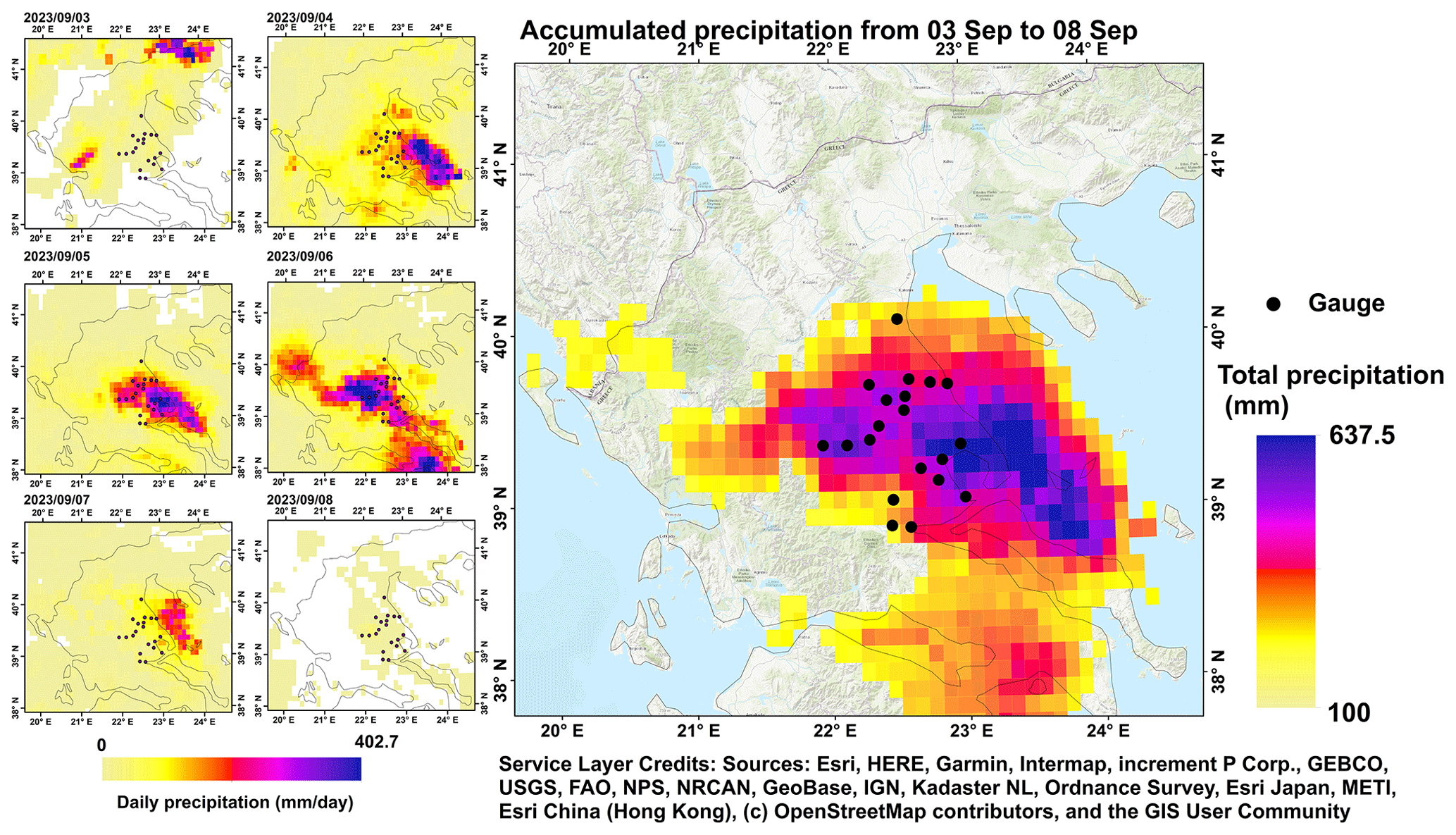
Figure 1Spatial distribution of gauge and the daily accumulated precipitation from bias-adjusted IMERG data in the period 3–8 September 2023 during Storm Daniel in Greece. © OpenStreetMap contributors 2023. Distributed under the Open Data Commons Open Database License (ODbL) v1.0.
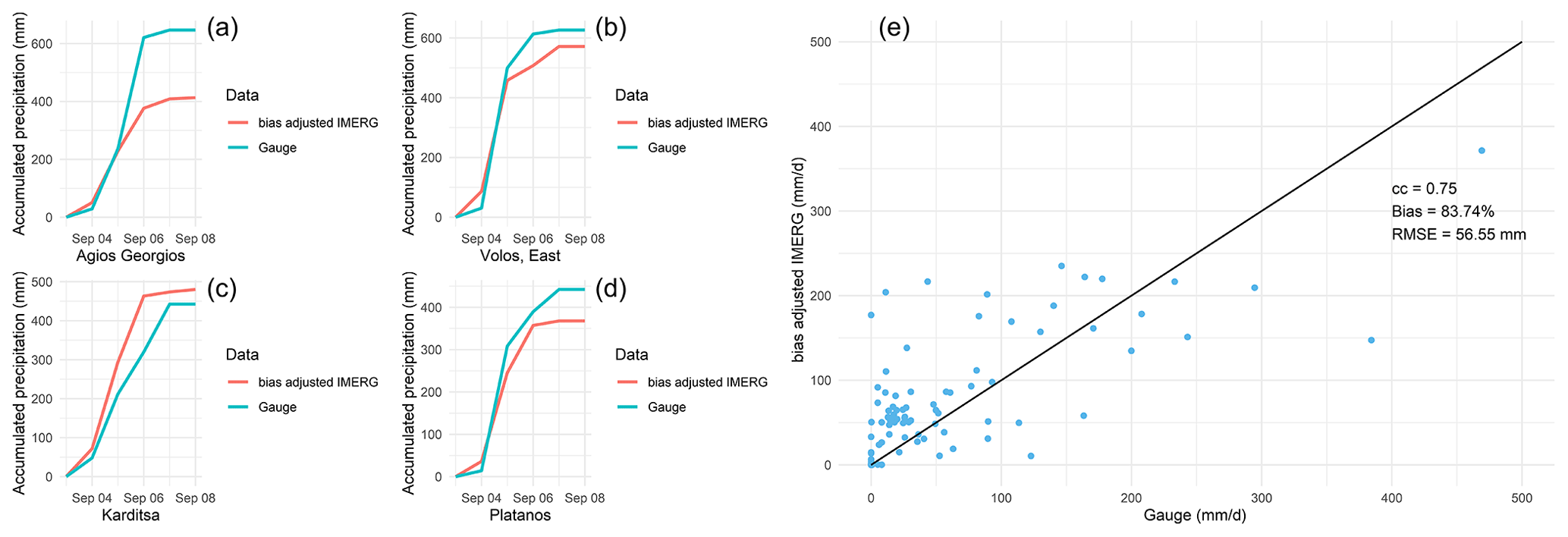
Figure 2Validation of the bias-adjusted IMERG data against gauge data with line charts showing the accumulated precipitation from 3 to 8 September 2023 for four gauges: (a) Agios Georgios, (b) Volos (east), (c) Karditsa, and (d) Platanos. (e) Scatterplot of the bias-adjusted IMERG daily precipitation against gauges.
Figure 2 shows the validation of the bias-adjusted IMERG data against the gauge data. The line charts of the accumulated precipitation, based on the bias-adjusted IMERG data and data from four gauges (where more than 450 mm of accumulated precipitation was observed), indicate that the bias-adjusted IMERG data could successfully capture the trends in precipitation increase, especially for the cities of Volos and Karditsa and the village of Platanos, for which the precipitation amounts for the bias-adjusted IMERG data and the observed IMERG data were close. The scatterplot comparing the bias-adjusted IMERG data with the gauge data shows that the former overestimated the precipitation amount by ∼ 84 %, with the overestimation occurring mainly with low precipitation (below 100 mm d−1). The CC and RMSE between the bias-adjusted IMERG data and gauge data were 0.75 and 56.55 mm, respectively.
Figure 3 presents the inundation extents from RAPID in Greece. The RAPID inundation map is highly consistent with the precipitation map. We derived an inundated area totaling 1150 km2 from RAPID, with most of the flooded areas found in the Thessalian plain along the Pineios River (∼ 820 km2) and associated with the accumulated precipitation totaling more than 400 mm that fell in these regions. We determined the inundated areas of the main land cover types by overlaying inundation extents with the CORINE Land Cover map. Among them, around 70 % were agricultural areas (∼ 574 km2), followed by forests (17 %), wetlands (10 %), and artificial surfaces (3 %). The inundated agricultural areas were primarily located in the Thessalian plain.
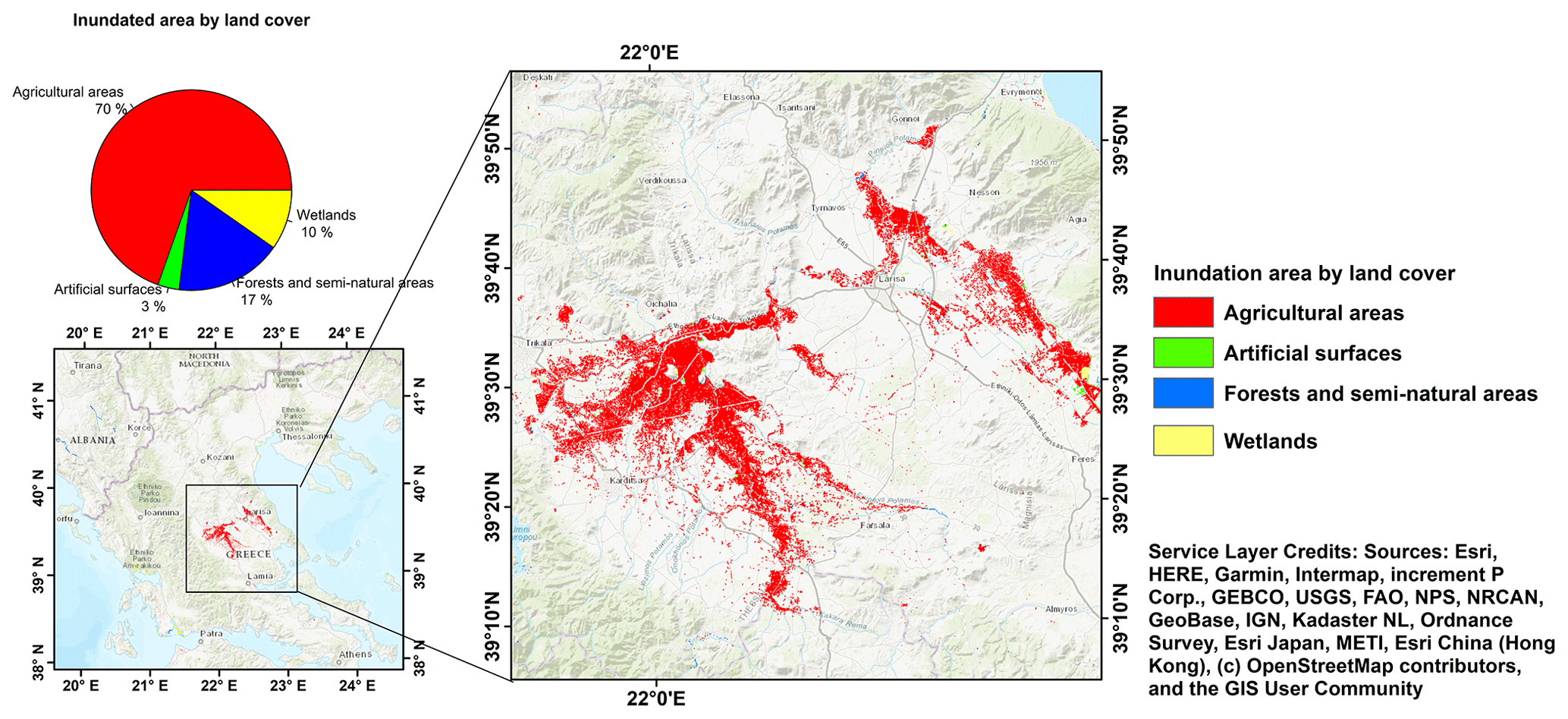
Figure 3Inundation extents from RAPID in Greece with inundated areas for the land cover type. The RAPID inundation map was retrieved using the SAR images available on 6 and 12 September. © OpenStreetMap contributors 2023. Distributed under the Open Data Commons Open Database License (ODbL) v1.0.
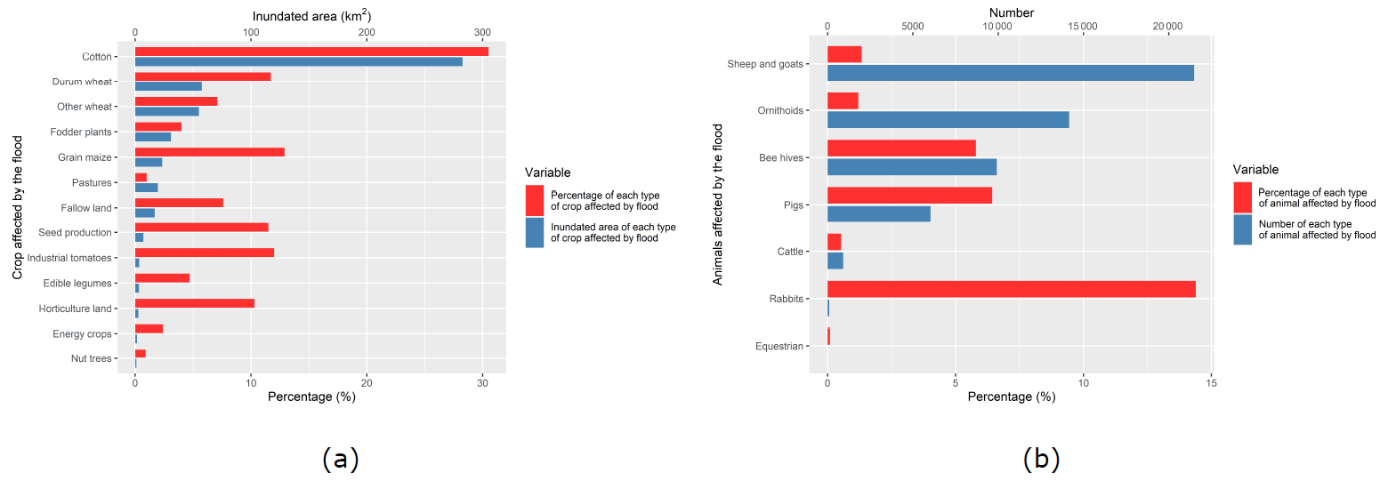
Figure 4(a) The inundated area and percentage of each type of crop affected by flooding in the Thessalian plain. (b) The number and percentage of each type of animal affected by flooding in the Thessalian plain.
Using the detailed distribution data of crop type and livestock in the Thessalian plain, we then analyzed the flood impact on each type of crop and livestock. Figure 4a displays the inundated area for each crop type as a fraction of the total land area planted with that crop in the Thessalian plain. Cotton was the crop most obviously affected by the flooding, with ∼ 282 km2 of its cultivation area flooded; this occupies 30.5 % of the total cotton area in the Thessalian plain. The inundated area was 57.5 km2 for durum wheat and 55 km2 for other wheats, accounting for 11.7 % and 7.1 %, respectively, of the area planted with these crops. Also affected by the flooding were fodder plants and grain maize, with 30.9 and 23.3 km2, or 4 % and 12.9 %, respectively, of their cultivation areas inundated. Although a relatively large portion of pasture was inundated (∼ 19.6 km2), this accounted for only 1 % of the total pasture area. On the other hand, the inundated areas of seed production and industrial tomatoes were low, at 7.1 and 3.5 km2, respectively, but they occupied 11.5 % and 12 % of the total areas planted with these crops.
Figure 4b shows the numbers of farms holding different types of livestock in the Thessalian plain, the numbers and percentages of those farms that were flooded by Storm Daniel, and the number and percentage of each type of animal affected by flooding. Among those holding ornithoids, we estimated four farms were flooded; the 14 161 animals affected comprised 1.2 % of the total number of ornithoids in the Thessalian plain. A total of 126 farms holding sheep and goats were also flooded, with 21 490 (or 1.33 %) of these animals affected. Other inundated farms included 58 with beehives, 25 with cattle, and 3 with pigs. Among these, 9915 beehives (5.79 %), 918 heads of cattle (0.52 %), and 6031 pigs (6.43 %) were affected. The least amount of loss occurred among rabbits and horses, with 100 and 4, respectively, affected.
The unprecedented precipitation event associated with Storm Daniel severely damaged agriculture and animal husbandry in central Greece. For this communication, we analyzed the flood impact in the region by overlaying the inundation extent derived from the RAPID system with CORINE Land Cover data and detailed distribution data on crop type and animal holding in the Thessalian plain, providing the estimated inundated area for each crop and the numbers of animals affected by the flooding. As a fully automated system, RAPID delineates NRT inundation extents from high-resolution (10 m) SAR imagery. SAR operates in the microwave frequency range, allowing it to penetrate through clouds and acquire data both day and night. The consistent and timely data acquisition this ensures is particularly crucial during emergency flood events (Shen et al., 2019b; Hostache et al., 2018; Manavalan, 2017). With these unique capabilities, RAPID can provide timely, accurate, and reliable flood mapping, enabling swift decision-making and effective response strategies in the event of a flooding hazard (Yang et al., 2021; Shen et al., 2019a). The main systematic errors in the RAPID system come from the IMERG data which are used to trigger the RAPID system. IMERG data have been found to overestimate light precipitation and overestimate heavy precipitation over Greece and to produce many false-alarm events (Kazamias et al., 2022, 2017). Despite the inherent correction and calibration algorithms within IMERG, there is a necessity for further refinement of IMERG data to more accurately represent precipitation distribution at diverse locations (Navarro et al., 2019; Tapiador et al., 2020; Kazamias et al., 2022; Gentilucci et al., 2022). Such enhancements could greatly benefit from leveraging dense gauge networks, providing a more granular and precise calibration of precipitation measurements. From the RAPID inundation map, we derived an inundated area totaling 820 km2 in the Thessalian plain in central Greece. Of this, 62 % (∼ 511 km2) was agricultural land, in which cotton suffered the most severe damage from flooding. The inundated area of cotton amounted to 282 km2, occupying ∼ 30 % of the total area planted with that crop in central Greece. Wheat was also affected by the flooding, with 57 km2 of durum wheat and 55 km2 of other wheat inundated. The expected result of these impacts is a severe reduction in agricultural production in Greece. As for livestock, we estimate that more than 14 100 ornithoids and 21 400 sheep and goats were affected by the flooding, a loss that is expected to influence the country's animal husbandry economy. These numbers only account for animals in the flooded area in the Thessalian plain; both immediate and subsequent impacts, such as disease and a lack of food, mean that the actual number of animals drowned or otherwise affected by the storm throughout Greece has probably increased.
The time needed for inundated crops to recover varies significantly, depending on such factors as crop type, growth stage, the duration of inundation, the degree of soil erosion caused by the flood, and the water quality of the floodwaters. Cotton cultivation is generally more resilient than other crop types, especially during its growing season. The recovery time can range from weeks to months if the inundation does not last more than a few days, soil erosion is not significant, and plant diseases are not caused by stagnant water. Since cotton seeding in Thessaly usually occurs in the spring, we can make no certain assessment at this moment of the flooding impacts on the upcoming cultivation period there. We can say, however, that in this region, where large areas remained inundated for several days or even weeks and the magnitude of the disaster limited opportunities to restore the drainage network quickly, damage to specific crops – for example, tree plantations – will probably be very high and the consequences will be worse if most of the flooded area sees unfavorable weather conditions before the next planting. Field surveys will be essential to evaluate the flood's impact on crops, considering factors such as flood depth, affected crop types (annual and perennial), erosion, and soil composition changes. Crop damage should be classified, and the economic impact should be estimated (AUA, 2023). Additional analysis of flood impacts on agriculture, including crop damage and yield loss would potentially aid in more effective flood management and mitigation strategies. Besides this, analyzing the inundation duration through hydrological models and remote sensing could provide critical insights into flood resilience and recovery processes.
With extreme weather increasing worldwide, demands are growing for quick and accurate hazard monitoring and prediction globally. Future directions of this study will include improving the frequency and coverage of the NRT RAPID inundation estimates by utilizing modern satellite constellations (for example, ICEYE, Ignatenko et al., 2020) and combining the estimates with flood models and crop data to predict the extent of flood damage to cropland (Lazin et al., 2021) and associated socioeconomic impacts (Gould et al., 2020).
The R software library is available at https://www.r-project.org/ (last access: 15 September 2023, Chambers, 2008). The ArcGIS software is available at https://www.esri.com/en-us/arcgis/products/arcgis-pro/overview (last access: 15 September 2023, Scott and Janikas, 2009).
The Integrated Multi-satellitE Retrievals for GPM (Global Precipitation Mission) (IMERG) Late Precipitation L3 V06 product is available at https://doi.org/10.5067/GPM/IMERG/3B-HH-L/06 (Huffman et al., 2019). The precipitation gauge data are accessible from WunderMap (https://www.wunderground.com/wundermap, Weather Underground, 2024). The land cover data for Greece from the CORINE Land Cover (CLC) inventory are available at https://land.copernicus.eu/pan-european/corine-land-cover/clc2018 (last access: 18 September 2023, Büttner, 2014). The inundation map of Greece from RAPID and the crop type and livestock distribution maps for the Thessalian plain are available from the corresponding author upon reasonable request.
KH: formal analysis, writing (original draft and editing). QY, ED, and AM: software, formal analysis, data curation. CP: writing, formal analysis. MS: review and editing. XS and ENA: conceptualization, project administration, writing (review and editing).
The contact author has declared that none of the authors has any competing interests.
Publisher’s note: Copernicus Publications remains neutral with regard to jurisdictional claims made in the text, published maps, institutional affiliations, or any other geographical representation in this paper. While Copernicus Publications makes every effort to include appropriate place names, the final responsibility lies with the authors.
This research was supported by a National Science Foundation Harnessing the Data Revolution (HDR) award entitled “Collaborative Research: Near term forecast of global plant distribution, community structure, and ecosystem function”. Kang He received the support of the China Scholarship Council for 4-year PhD study at the University of Connecticut (under grant agreement no. 201906320068).
This research has been supported by the National Science Foundation (grant no. 1934712).
This paper was edited by Animesh Gain and reviewed by two anonymous referees.
AP News: The cost of damage from the record floods in Greece's breadbasket is estimated to be in the billions, https://apnews.com/article/greece-breadbasket-floods-thessaly-cost-c2369f2450542a9aa0dc94556e28be5e, last access: 18 September 2023.
AUA: The Agricultural University of Athens proposes solutions for the devastating floods that struck Thessaly, https://www2.aua.gr/en/news-events/nea/agricultural-university-athens-proposes-solutions-devastating-floods-struck-thessaly, last access: 23 September 2023.
Büttner, G.: CORINE land cover and land cover change products, in: Land use and land cover mapping in Europe: practices & trends, edited by: Manakos I. and Braun, M., Dordrecht, Springer Netherlands, 55–74, https://doi.org/10.1007/978-94-007-7969-3_5, 2014 (data available at: https://land.copernicus.eu/pan-european/corine-land-cover/clc2018).
CBS: Greece wildfires are so intense they've spewed more emissions in a week than July wildfires in 2 decades, https://www.cbsnews.com/news/greece-wildfires-record-emissions/, last access: 18 September 2023a.
CBS: “Historic flooding event” in Greece dumps more than 2 feet of rain in just a few hours, https://www.cbsnews.com/news/greece-historic-flooding-more-than-2-feet-of-rain-in-just-a-few-hours/, last access: 18 September 2023b.
CBS: Flooding in Greece and neighboring nations leaves 14 dead, but 800 rescued from the torrents, https://www.cbsnews.com/news/greece-flooding-deaths-rescues-turkey-bulgaria-climate-change-severe-weather/, last access: 18 September 2023c.
Chambers, J. M.: Software for data analysis: Programming with R, Vol. 2, New York, Springer, https://doi.org/10.1007/978-0-387-75936-4, 2008 code available at: https://www.r-project.org/).
CNN: More than 800 rescued after extreme flooding in Greece turns villages into lakes, https://www.cnn.com/2023/09/07/europe/greece-floods-storm-rescue-climate-intl/index.html, last access: 18 September 2023.
eKathimerini: Almost 70 % of cotton cultivation in Thessaly damaged by storm, says expert, https://www.ekathimerini.com/economy/1220146/almost-70-of-cotton-cultivation-in-thessaly-damaged-by-storm-says-expert/, last access: 18 September 2023.
European Commission: Energy, Climate change, Environment: Knowledge Hub for Water, https://water.jrc.ec.europa.eu/pdf/pinios-fs.pdf, last access: 19 September 2023.
FATIMA: Greece – Thessaly Pilot, http://fatima-h2020.eu/pilots/greece-thessaly/, last access: 19 September 2023.
Financial Times: Extreme flooding caused by Storm Daniel devastates Greece, https://www.ft.com/content/b46d34c0-fef8-45f2-8930-a01c10b4d13a, last access: 18 September 2023.
FloodList: Greece – “Unimaginable Amounts of Water” as Floods and Rain Continue, http://floodlist.com/europe/greece-floods-september-2023, last access: 18 September 2023.
Gentilucci, M., Barbieri, M., and Pambianchi, G.: Reliability of the IMERG product through reference rain gauges in Central Italy, Atmos. Res., 278, 106340,, https://doi.org/10.1016/j.atmosres.2022.106340, 2022.
Gould, I. J., Wright, I., Collison, M., Ruto, E., Bosworth, G., and Pearson, S. The impact of coastal flooding on agriculture: A case-study of Lincolnshire, United Kingdom, Land Degrad. Dev., 31, 1545–1559, 2020.
Greek Payment Authority of Common Agricultural Policy Aid Schemes: Maps of crop type and livestock distribution in Thessaly, Hellenic Ministry of Rural Development and Food, https://www.opekepe.gr/en/ (last access: 18 September 2023), 2021.
GreekReporter: The EU Offers Greece € 2.25 Billion to Recover From Deadly Floods, https://greekreporter.com/2023/09/13/greece-2-25-billion-eu-recover-floods/, last access: 18 September 2023a.
GreekReporter: Agriculture in Greece Devastated by the Deadly Floods, https://greekreporter.com/2023/09/16/agriculture-greece-devastated-deadly-floods/, last access: 18 September 2023b.
He, K., Yang, Q., Shen, X., and Anagnostou, E. N.: Brief communication: Western Europe flood in 2021 – mapping agriculture flood exposure from synthetic aperture radar (SAR), Nat. Hazards Earth Syst. Sci., 22, 2921–2927, https://doi.org/10.5194/nhess-22-2921-2022, 2022.
Hellenic Statistical Authority of Greece: Statistics-Gross Value Added by Industry 2020, https://www.statistics.gr/en/statistics/-/publication/SEL45/2020, last access: 26 September 2023.
Hostache, R., Chini, M., Giustarini, L., Neal, J., Kavetski, D., Wood, M., and Matgen, P.: Near-real-time assimilation of SAR-derived flood maps for improving flood forecasts, Water Resour. Res., 54, 5516–5535, https://doi.org/10.1029/2017WR022205, 2018.
Huffman, G. J., Stocker, E. F., Bolvin, D. T., Nelkin, E. J., and Tan, J.: GPM IMERG Late Precipitation L3 Half Hourly 0.1 degree x 0.1 degree V06, Greenbelt, MD, Goddard Earth Sciences Data and Information Services Center (GES DISC) [data set], https://doi.org/10.5067/GPM/IMERG/3B-HH-L/06, 2019.
Hürriyet Daily News: Floods wiped out quarter of Greek farm produce, https://www.hurriyetdailynews.com/floods-wiped-out-quarter-of-greek-farm-produce-186293, last access: 18 September 2023.
Ignatenko, V., Laurila, P., Radius, A., Lamentowski, L., Antropov, O., and Muff, D.: ICEYE Microsatellite SAR Constellation Status Update: Evaluation of first commercial imaging modes, in: IGARSS 2020–2020 IEEE International Geoscience and Remote Sensing Symposium, 3581–3584, IEEE, 2020.
Kazamias, A. P., Sapountzis, M., and Lagouvardos, K.: Evaluation and intercomparison of GPM-IMERG and TRMM 3B42 daily precipitation products over Greece, Fifth International Conference on Remote Sensing and Geoinformation of the Environment (RSCy2017), Vol. 10444, SPIE, https://doi.org/10.1117/12.2279689, 2017.
Kazamias, A.-P., Sapountzis, M., and Lagouvardos, K.: Evaluation of GPM-IMERG rainfall estimates at multiple temporal and spatial scales over Greece, Atmos. Res., 269, 106014, https://doi.org/10.1016/j.atmosres.2022.106014, 2022.
Lazin, R., Shen, X., and Anagnostou, E.: Estimation of flood-damaged cropland area using a convolutional neural network, Environ. Res. Lett., 16, 054011, https://doi.org/10.1088/1748-9326/abeba0, 2021.
Manavalan, R.: SAR image analysis techniques for flood area mapping-literature survey, Earth Sci. Inform., 10, 1–14, 2017.
NASA: A Deluge in Greece, https://earthobservatory.nasa.gov/images/151807/a-deluge-in-greece, last access: 18 September 2023.
Navarro, A., García-Ortega, E., Merino, A., Sánchez, J. L., Kummerow, C., and Tapiador, F. J.: Assessment of IMERG precipitation estimates over Europe, Remote Sensing, 11, 2470, https://doi.org/10.3390/rs11212470, 2019.
NBC News: Death toll hits 11,300 in Libyan city destroyed by floods, https://www.nbcnews.com/news/world/libya-floods-death-toll-derna-rcna105001, last access: 19 September 2023.
PBS: Wildfires rage outside Athens as scorching European heat wave continues, https://www.pbs.org/newshour/world/wildfires-rage-outside-athens-as-scorching-european-heat-wave-continues, last access: 18 September 2023.
Scott, L. M. and Janikas, M. V.: Spatial statistics in ArcGIS, in: Handbook of applied spatial analysis: Software tools, methods and applications, Berlin, Heidelberg, Springer Berlin Heidelberg, 27–41, 2009 (code available at: https://www.esri.com/en-us/arcgis/products/arcgis-pro/overview).
Shen, X., Anagnostou, E. N., Allen, G. H., Brakenridge, G. R., and Kettner, A. J.: Near-real-time non-obstructed flood inundation mapping using synthetic aperture radar, Remote Sens. Environ., 221, 302–315, 2019a.
Shen, X., Dacheng, W., Kebiao, M., Anagnostou, E. N., and Hong, Y.: Inundation Extent Mapping by Synthetic Aperture Radar: A Review, Remote Sensing, 11, 879, https://doi.org/10.3390/rs11070879, 2019b.
Sky: The missed chances to save Libya's flood victims from disaster, https://news.sky.com/story/the-missed-chances-to-save-libyas-flood-victims-from-disaster-12961863, last access: 19 September 2023.
Tapiador, F. J., Navarro, A., García-Ortega, E., Merino, A., Sánchez, J. L., Marcos, C., and Kummerow, C.: The contribution of rain gauges in the calibration of the IMERG product: Results from the first validation over Spain, J. Hydrometeorol., 21, 161–182, 2020.
The New York Times: Extreme Weather in Greece Traps Residents and Submerges Villages, https://www.nytimes.com/2023/09/07/world/europe/greece-turkey-floods.html, last access: 18 September 2023.
Weather Underground: WunderMap Precipitation Gauge Data, https://www.wunderground.com/wundermap (last access: 18 September 2023), 2024.
Yang, Q., Shen, X., Anagnostou, E. N., Mo, C., Eggleston, J. R., and Kettner, A. J.: A High-Resolution Flood Inundation Archive (2016–the Present) from Sentinel-1 SAR Imagery over CONUS, B. Am. Meteorol. Soc., 102, E1064–E1079, https://doi.org/10.1175/BAMS-D-19-0319.1, 2021.