 | 19 Apr 2023
Brief communication: The northwest Himalaya towns slipping towards potential disaster
The NW Himalaya (India) has been one of the most affected terrains of the Himalaya, subject to frequent disastrous landslides owing to active tectonics and multiple precipitation sources. This article focuses on two towns (Joshimath and Bhatwari) of Uttarakhand in the NW Himalaya, which have been witnessing subsidence for decades. Up until 9 January 2023, Joshimath had witnessed widespread cracks in more than 500 houses, which has prompted social unrest in the region. The hillslopes surrounding both towns comprise highly jointed gneisses with schistose interlayer rock mass. Both towns have subsidences and holes in the road, broken retaining walls, and displaced boulders, and the houses have cracks in the walls and holes. Recently, such slope instability phenomena have increased, which is leading to social movements in the region seeking government action such as possible evacuation and rehabilitation. The present study used a continuum-modelling-based slope stability simulation to determine the response of these hillslopes under various loading conditions: gravity, rainfall, building load, domestic discharge, and seismic load. Results revealed that the displacement in these hillslopes might reach up to 20–25 m, which will further aggravate the situation. The occurrence of frequent extreme rainfall in these towns and three major earthquakes, which occurred on 1 September 1803 (Mw 7.8), 20 October 1991 (Mw 6.8), and 29 March 1999 (Mw 6.6), having a hypocentral distance less than 30 km makes such a study more viable for decision making.


The NW Himalaya has been one of most affected terrains of the Himalaya, subject to frequent disastrous landslides (Martha et al., 2015; Gupta et al., 2016; Kumar et al., 2021b). Continent–continent collisional orogeny caused active tectonics and multiple precipitation sources, i.e. the Indian summer monsoon (ISM) and western disturbances caused extreme rainfall and are the main causes of such landslides (Petley, 2010; Dimri et al., 2015). The NW Himalaya experienced ∼ 51 % of all the landslides in India during the years 1800–2011 (Parkash, 2011). This article focuses on two towns (Joshimath and Bhatwari) of Uttarakhand in the NW Himalaya, which have been witnessing subsidence for decades. Notably, Uttarakhand has been subject to four known major flood events in the last 5 decades, which occurred on 24–26 August 1894, 20 July 1970, 16–17 June 2013, and 7 February 2021 (Ziegler et al., 2014; Sundriyal et al., 2015; Rana et al., 2021). Apart from floods, three major earthquakes have also caused widespread damage to the region. They occurred on 1 September 1803 (Mw 7.8), 20 October 1991 (Mw 6.8), and 29 March 1999 (Mw 6.6) (Bilham, 2019). Joshimath (Fig. 1) had a population of 16 709 as per the last census (2011) of the government of India and must have reached at least 18 630 by now, as per an 11.5 % population growth (https://main.mohfw.gov.in/, data retrieved on 10 August 2022).
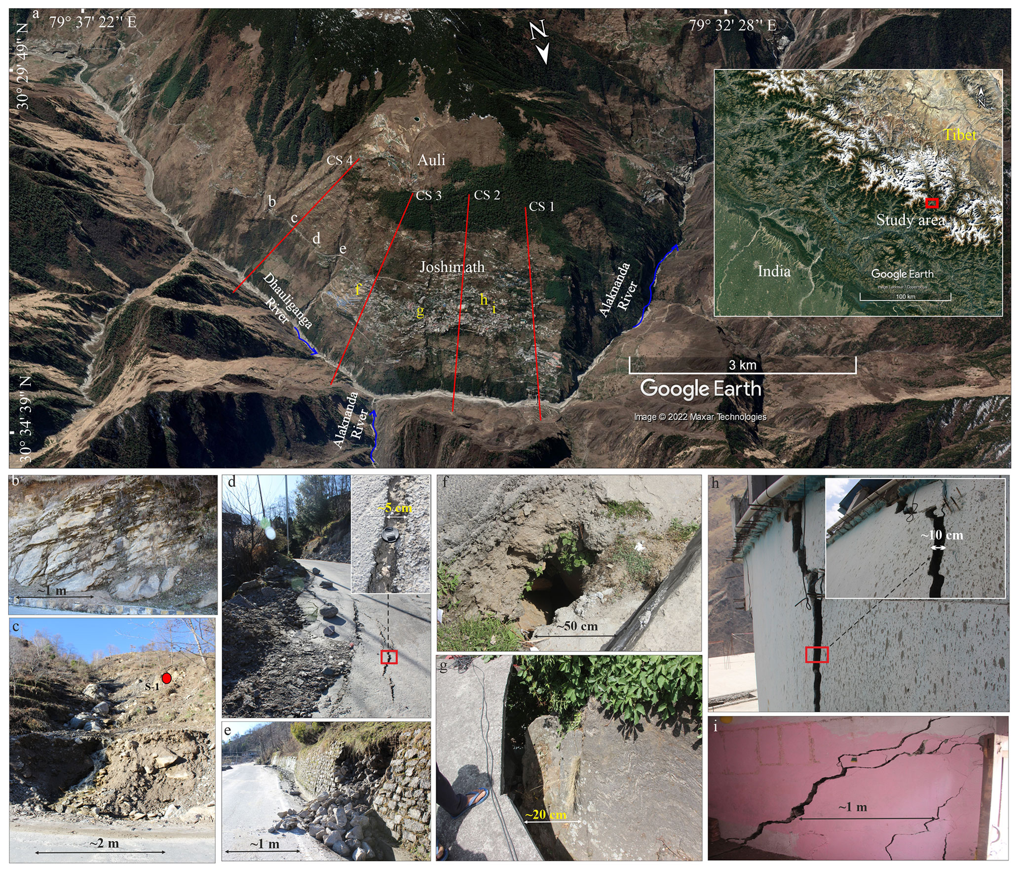
Figure 1Field observation of Joshimath. (a) Location of Joshimath with the inset highlighting its position in the NW Himalaya. © Google Earth for panel (a). CS 1 to CS 4 mark the position of 2D slope sections used for the slope stability evaluation. (b) Rock mass exposure and (c) natural drainage (Nala) through the hillslope. Position of soil sampling site (S-1), (d) cracks and displacement in the road, (e) bulging and collapse of retaining wall, (f–g) displaced hillslope material and hence displaced pavements, and (h–i) cracks in houses. Picture (f–i) courtesy: Atul Sati.
This town has witnessed widespread cracks in more than 500 houses, and even in temples, up until 9 January 2023, which is prompting social unrest. Various media reports involving interviews with experts are aimed at the potential role of infrastructural projects in promoting instability in this region (https://timesofindia.indiatimes.com/city/dehradun/ uttarakhand-joshimath-land-subsidence-cracks-sinking-news-live-updates-8-january2023/liveblog/96843072.cms, last access: 12 January 2023). The town is situated along a narrow gorge at the confluence of two major rivers: Dhauliganga and Alaknanda. The gorge owes its existence to exhumation along the Main Central Thrust (MCT) fault passing through the southern side of the town (Supplement Fig. S1). This orographic barrier results in 798±116 mm yr−1 avg annual (years 2000–2021) rainfall in the town (Supplement Fig. S2). The uncertainty in rainfall refers to the standard error of the mean. In a recent study by Agarwal et al. (2022), they found that the town belongs to a hotspot, which is experiencing changing climate and rapid anthropogenic influence. Field observation of the town revealed that the hillslope of the town comprises highly jointed gneisses with schistose interlayer rock mass, and both towns have subsidences and holes in the road, broken retaining walls, and displaced boulders, and the houses have cracks in the walls and holes (Fig. 1). Loose hillslope material comprising sandy gravel soil (Fig. 1c), exposed on the eastern part of the town, points towards the possibility of a paleo-landslide on which most of the town is located. The last big earthquake (29 March 1999: Mw 6.6) occurred within a 26 km hypocentral distance from this town.
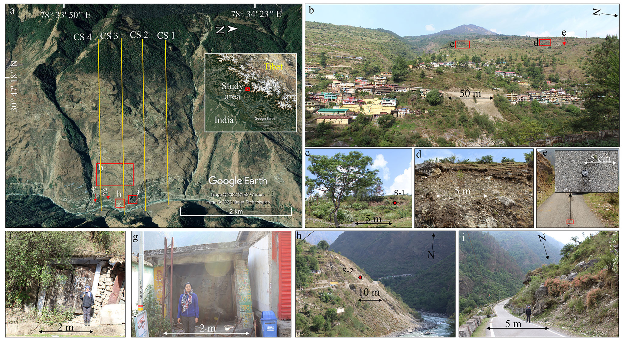
Figure 2Field observation of Bhatwari. © Google Earth for panel (a). (a) Location of Bhatwari with the inset highlighting its position in the NW Himalaya. CS 1 to CS 4 mark the position of 2D slope sections used for the slope stability evaluation. (b–d) Exposed scarp. S-1 refers to the soil sampling site, (e) cracks and displacement of the road, (f–g) tilting houses and shops, (h) active slope failure at the slope toe, and (i) big gneissic boulder implying a paleo-landslide site.
Another town that is included in this article is Bhatwari (Fig. 2). As per the census (2011) of the government of India, it had a population of 1268 that is 1.0 % lower than that of the year 1991. Though the population migration from hilly terrains to plain areas is becoming a common phenomenon in the NW Himalaya owing to socioeconomic priorities, the decreasing human population of this town might also be due to such slope instability problems. Similar to Joshimath, Bhatwari is also situated along a narrow gorge incised by the Bhagirathi River Valley. The hillslope of the town comprises gneissic rock mass, and the MCT-I (locally termed the Vaikrita Thrust: VT) and MCT-II (locally termed the Munsiyari Thrust: MT) faults pass through the northern and southern sides, respectively, of this region (Supplement Fig. S1). Two tributaries merging into the Bhagirathi River bound the hillslope from the northern and southern sides. Bhatwari is also situated on the orographic barrier setting and hence receives 1063±124 mm yr−1 avg annual (years 2000–2021) rainfall (Supplement Fig. S2). Field observation revealed exposed scarps in the upper part of the town, cracks in the road, and tilting houses (Fig. 2b–g). Big (1.2–1.5 m) boulders and active slope failure in the loose material at the slope toe indicate the possibility of a paleo-landslide on which Bhatwari is located (Fig. 2h–i). Yadav et al. (2020) have also noted the material displacement in the range of 12–22 mm yr−1 during the years 2006–2016 at this location. The last big earthquakes (1 September 1803: Mw 7.8; 20 October 1991: Mw 6.8) occurred within a 22 km hypocentral distance from this town.
These two towns were selected because both are subject to similar lithotectonic conditions and precipitation patterns (owing to the orographic barrier setting). Since both of these locations comprise surficial cracks, displaced boulders, and exposed scarp, the possibility of the existence of a paleo-landslide cannot be ignored. Though a detailed geophysical survey is being planned for future prospects to understand the subsurface regime at these locations, the present study used a continuum-based (finite element method) slope stability simulation.
This simulation was performed to determine the response of hillslopes that surround these towns under various loading conditions: gravity, rainfall, building load (B), domestic discharge (DD), and seismic load. Rainfall infiltration (RF) is based on extreme rainfall of 122 mm d−1 (18 October 2021) and 124 mm d−1 (26 July 2010) at Joshimath and Bhatwari, respectively (Supplement Fig. S2. Data source: GPM IMERG Final Precipitation (Huffman et al., 2020), spatial resolution: ∼ 1 km). Domestic discharge infiltration and building load are based on the Indian standard (IS) code 2470 (Part 1) – 1985 and the Indian standard (IS) code 875 (Part 2) – 1987, respectively. Domestic discharge refers to the liquid waste of a house, whereas building/house load refers to uniformly distributed loads of houses. Domestic discharge load was considered because these towns lack effective sewage management plans. The values of domestic discharge (sewage and sullage) is based on the Indian standard (IS) code 2470 (Part 1) – 1985, pp. 8. According to this code, for a family of a minimum of five members, probable peak domestic discharge may reach up to 9 L min−1, which equals to 0.00015 m3 s−1. This value was used in the hillslope as a point infiltration, and hence the unit of metres per second was considered. Notably, domestic discharge and building load are consistent in nature, whereas the rainfall infiltration is relatively random. Seismic loads are based on the 20 October 1991 (Mw 6.8) Uttarkashi earthquake and the 29 March 1999 (Mw 6.6) Chamoli earthquake acceleration history used for Bhatwari and Joshimath, respectively (Supplement Fig. S3. Data source: Department of Earthquake Engineering, Indian Institute of Technology, Roorkee, India, through the COSMOS web portal, http://www.cosmos-eq.org/, retrieved on 3 August 2022).
This continuum simulation method has been used for various hillslopes of the NW Himalaya owing to flexibility in the slope geometry solution and the acceptable approximation of displacement output (Kumar et al., 2021b). For estimating a large strain, particularly during the dynamic analysis, discontinuum modelling could be a better option as also noted by Havenith et al. (2003); see Kumar et al. (2021a). However, we also cannot deny the fact that the loose overburden and complex geometry can be better simulated using a continuum approach. Discontinuum modelling having a block concept also considers the finite difference method (one of the continuum approaches) mechanism for the deformation of blocks. Further, we used rainfall “vertical” infiltration and domestic discharge infiltration in our study directly on the slope surface to approximate a real scenario, which is limited in the discontinuum concept that allows for fluid transmission using joints only.
Details of slope configuration, material models, and input parameters is summarized in Supplement Annexure I. For both towns, four 2D slope sections (CS 1 to CS 4) were taken to minimize the uncertainty caused by subjectivity associated with a single slope section (Figs. 1, 2). A configuration model is shown in Supplement Fig. S4. Although the 3D slope stability could have been more informative, the subsurface regime is yet to be explored for a more comprehensive understanding.
Stability evaluation results for both locations are discussed using the total (horizontal and vertical component) displacement in the top 5–10 m material layer along the slope surface. If horizontal and vertical displacements refer to “x” and “y”, the total displacement is equivalent to . Displacement profiles for Joshimath revealed that the slope may yield a 1–4 m displacement under gravity load conditions. This gravity (or static) condition also refers to the equilibrium state. The gravity-caused displacement might increase by up to ∼ 6 m under the combined effect of rainfall (RF) infiltration, building/house load (B), and domestic discharge (DD) (Fig. 3). In Fig. 3, JM and BT refer to Joshimath and Bhatwari, respectively. The CS 1 and CS 3 sections of Joshimath yield relatively higher displacement under these loads, particularly near the slope toe. Under seismic load conditions, displacement increases rapidly in the range of 8–22 m, particularly at the knickpoints of the slope surface and near the slope toe. Relatively higher seismic displacement at the slope toe is attributed to stress accumulation at the slope toe and a narrow geomorphic setting, resulting in constructive seismic interference, as also noted in other case studies involving earthquake-induced landslides (Meunier et al., 2008). Notably, the slope crest region comprises a debris layer that must have affected topographic amplification and hence the relatively lower displacement, as also noted in a recent study in the SE Carpathians (Kumar et al., 2021a).
Similarly to the Joshimath hillslope, displacement profiles for the Bhatwari hillslope show dominance of higher displacement (up to ∼ 25 m) at the slope toe under seismic load conditions (Fig. 3). Notably, under the combined effect of rainfall, domestic discharge, and building load, the CS 1 and CS 2 sections of the Bhatwari slope comprise pockets of higher displacement (5–20 m), particularly near the slope toe. This could be attributed to a thicker debris deposit and a cluster of human settlement at the location of these slope sections (CS 1 and CS 2).
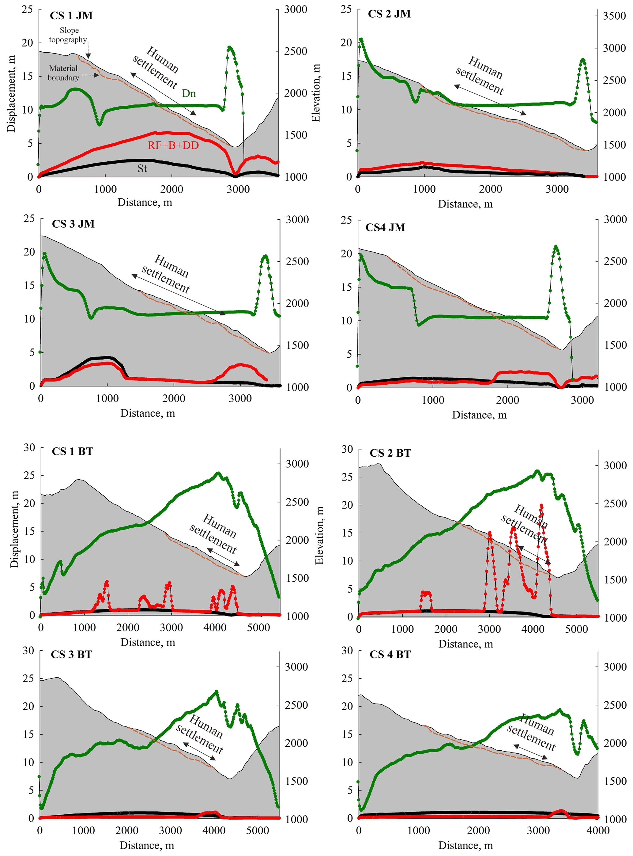
Figure 3Results of the slope stability evaluation. CS 1 JM to CS 4 JM refer to Joshimath slope sections, whereas CS 1 BT to CS 4 BT refer to slope sections of the Bhatwari hillslope. Dn, RF, B, DD, and St refer to dynamic, rainfall infiltration, building load, domestic discharge, and static load, respectively.
Field observations of surface cracks, tilting houses, and displaced hillslope material, as well as predictive findings of more displacement in the case of local (domestic discharge, building load) and external loads (rainfall, earthquake) emphasize the critical situation of these NW Himalayan towns. Notably, recent social movements in Joshimath seeking government action for possible evacuation, rehabilitation, and suspension of infrastructural projects (assumed as a major reason of hillslope instability) (https://timesofindia.indiatimes.com/city/dehradun/joshimath-sinking-thousands-of-fearful-residents-hit-road-in-protest/articleshow/96488198.cms, last access: 12 January 2023) make such a study more viable for decision making. A recent interferometric synthetic aperture radar (InSAR)-based study (https://discuss.terradue.com/t/results-of-advanced-insar-services-sentinel-1-indicate-that-the-town-of-joshimath-northern-india-is-sliding/1149, accessed on 11 February 2023) has also noted considerable displacement at the slope toe region, as predicted in this modelling-based study. In order to justify the findings of the present study, we selected one slope section i.e. CS-1 and took a traverse along it during 17–20 January 2023. Field visits revealed lateral and vertical cracks in the loose overburden near the slope toe region (Supplement Fig. S5d–e). Influx of domestic discharge into the slope that is estimated to increase displacement was also spotted at the poorly functioning sewage plant, which is shown in Supplement Fig. S5c. Widening cracks in the upper part of the slope was also noted, as shown in Supplement Fig. S5f.
As far as the cause of slope instability in Joshimath is concerned, a committee report (no. 142/28-5/44/76 dated 8 April 1976) submitted jointly by 17 experts headed by the late M. Mishra considered the paleo-landslide material as a major cause of slope instability. Google Earth imagery of June 2014 (Supplement Fig. S6) also indicates growing slope toe failure, possibly leading to retrogression. However, the contribution of anthropogenic impacts including population increase, continuing rapid construction to cater to the high tourist influx (Agarwal et al., 2022), and infrastructural projects cannot be denied. Unlike Joshimath, Bhatwari is witnessing a population decrease and a lack of tourist influx. Therefore, natural conditions i.e. loose material of the paleo-landslide coupled with excessive rainfall dominate as the causative factors.
Notably, Joshimath and Bhatwari occupy a cornerstone of the religious and political landscape of the NW Himalaya. With the emergent threats of cracks, this paper suggests a need for a robust study to develop an integrated approach involving detailed scientific study and people's grievances against/about the development projects. Further, there is an urgent need to develop an integrative framework that combines the social composition of the region, various forms of resilience/adaptation practices, and robust scientific inquiries. Often it is assumed that scientific factors that influence landscapes are well understood by and explained to the public. This invariably miscommunicates the potential threat, causing irreversible socioeconomic loss.